Retrieval of High-Resolution Aerosol Optical Depth for Urban Air Pollution Monitoring
Abstract
:1. Introduction
2. Study Area and Datasets
2.1. Study Area
2.2. Datasets
2.2.1. MODIS Data
2.2.2. GF-1 WFV Data
3. Methodology
3.1. AOD Retrieval Algorithm
3.2. Downscaling Method
- (1)
- Before downscaling, WFV and MODIS data should be reprojected and registered; consequently, RMSE should be less than 0.5 pixels.
- (2)
- The downscaled 100 m MODIS image should retain as much information as possible from the original 1 km MODIS image and the 100 m WFV image, and the maximum likelihood ratio between the two should be maximized. After downscaling, the physical meaning of each pixel and the range of pixel values should not be changed.
- (3)
- The downscaling process is reversible. That is to say, when the resolution of the downscaled 100 m MODIS Image reaches 1 km resolution, it can be restored to the same as the original image.
4. Results and Validation
4.1. Downscaled Results
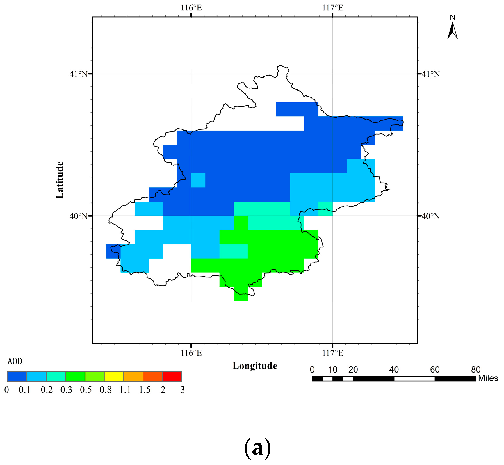
4.2. Spatial Distributions of Retrieved AOD Results over Beijing
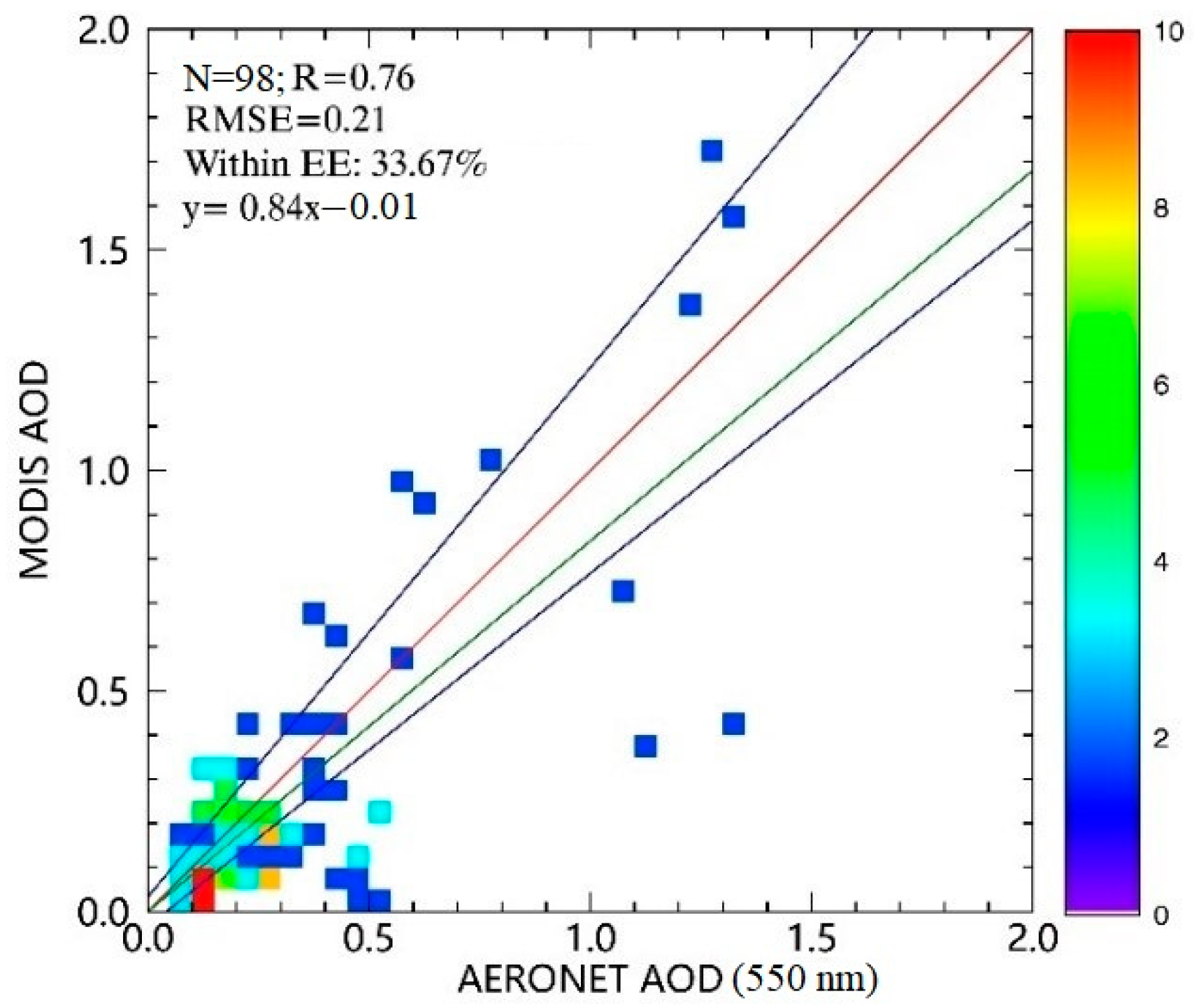
4.3. Comparison with Ground Measurements
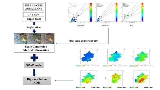
5. Research on the Pixel Scale of AOD Results with Different Resolutions
- (1)
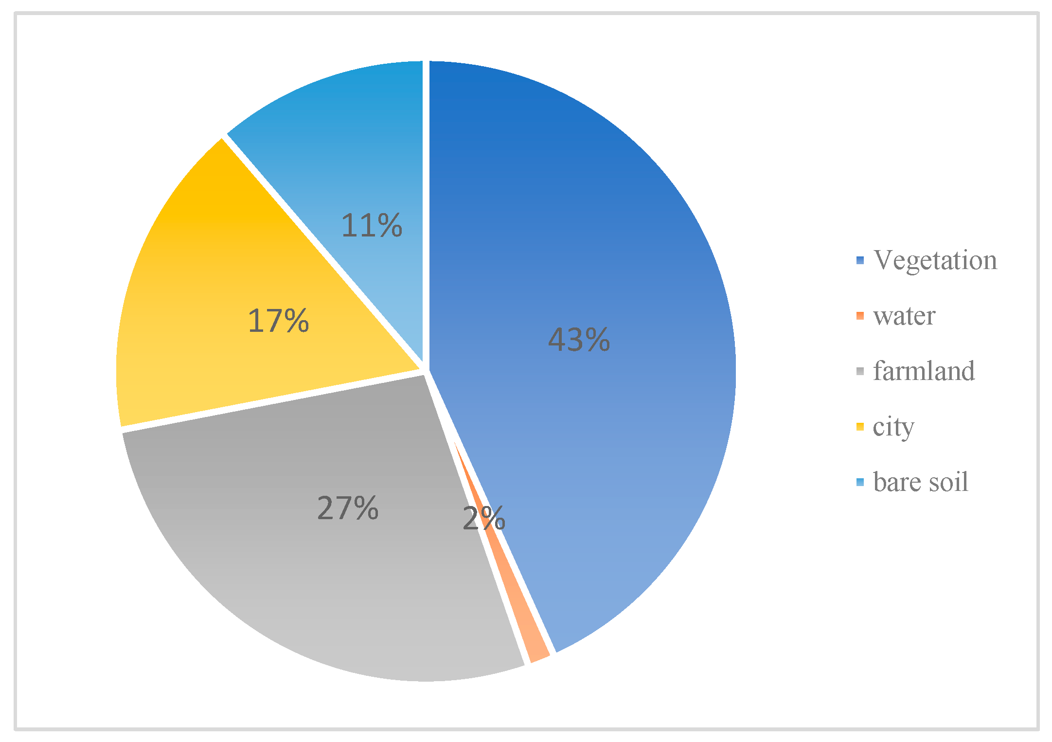
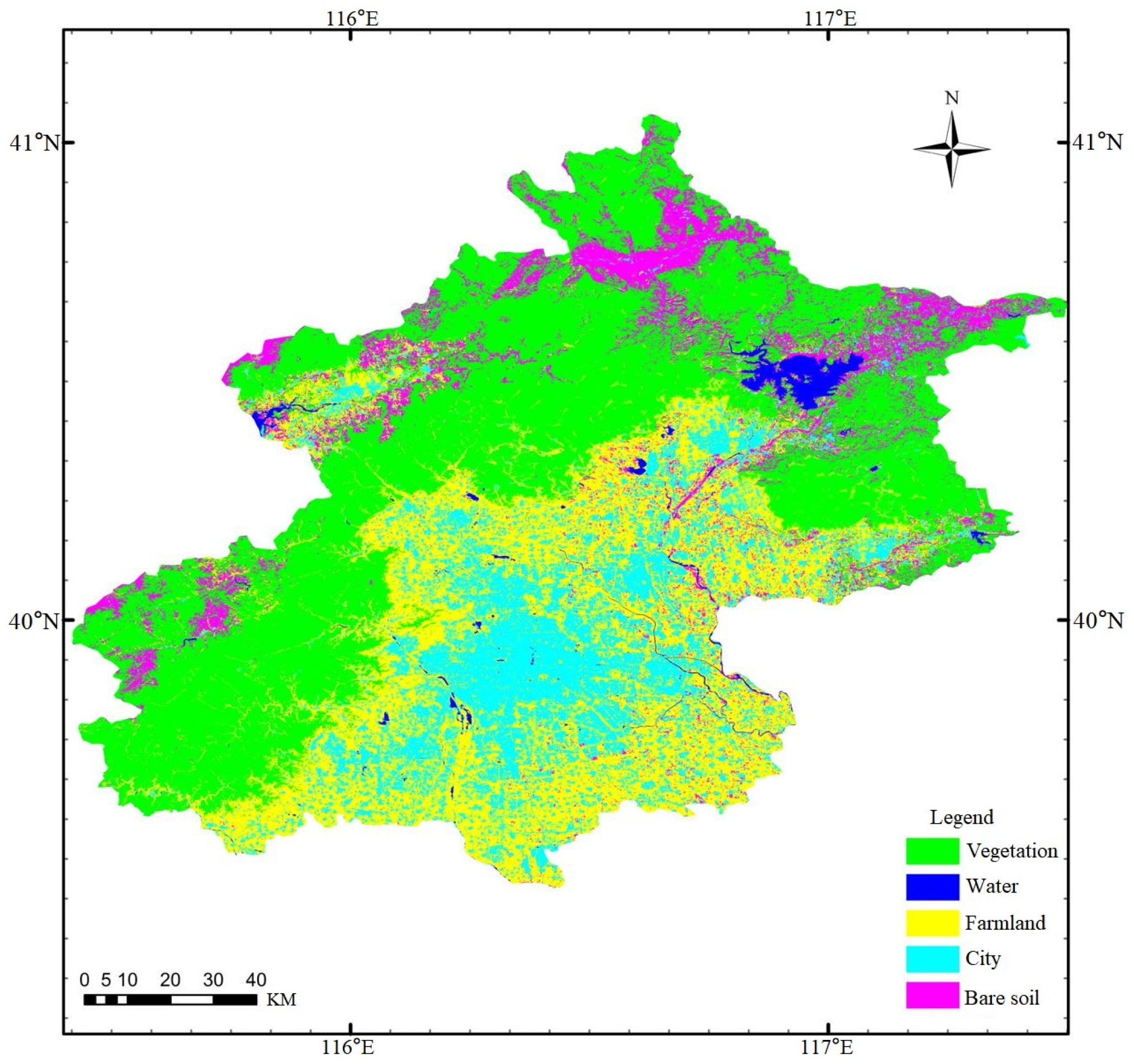
- For the vegetation areas, there is a little difference between the 50 m and 100 m AOD values. Each 100 m AOD pixel value is almost equal to the average of the sum of 4 50 m AOD pixel values, the gap between them is only two to three decimal places. From the classification results of GF-1 WFV images in Beijing, it can be clearly seen that the vegetation type has a high degree of separation, strong independence and single types. Therefore, 50 m resolution AOD can be calculated by a simple average of 100 m resolution AOD.
- (2)
- For the farmland areas, the pattern of the AOD scale conversion between 50 m and 100 m is not stable. Although most of 50 m AOD pixel values can be expressed as the average of the sum of 4 pixel values at 100 m resolution, there is a large gap between some pixels. By analyzing the land use types of Beijing, it can be seen that most of the farmland is distributed in the middle of the city or at the city boundary, which is easy to mix with the city and vegetation, resulting in mixed pixels. Moreover, due to the different crops, the farmland types will also be different, causing the unstable law between the two scales.
- (3)
- For urban areas, the regularity of the AOD between the 50 m and 100 m resolutions is not obvious. In some cases, the average of the 50 m 2 × 2 window is higher than 100 m, and sometimes, it is lower than 100 m. The two are quite different and have no regularity. This is because the urban land surface is complex. Therefore, almost every pixel is a mixed pixel with great uncertainty. As a result, the gap and law between the two cannot be determined in the end.
6. Conclusions and Future Work
Author Contributions
Funding
Institutional Review Board Statement
Informed Consent Statement
Data Availability Statement
Conflicts of Interest
References
- She, L.; Mei, L.; Xue, Y.; Che, Y.; Guang, J. SAHARA: A Simplified Atmospheric Correction Algorithm for Chinese GaoFen Data: 1. Aerosol Algorithm. Remote Sens. 2017, 9, 253. [Google Scholar] [CrossRef] [Green Version]
- Kaufman, Y.J.; Sendra, C. Algorithm for automatic atmospheric corrections to visible and near-IR satellite imagery. Int. J. Remote Sens. 1988, 9, 1357–1381. [Google Scholar] [CrossRef]
- Remer, L.A.; Mattoo, S.; Levy, R.C.; Munchak, L. MODIS 3 km aerosol product: Algorithm and global perspective. Atmos. Meas. Tech. 2013, 6, 69–112. [Google Scholar] [CrossRef] [Green Version]
- Levy, R.C.; Mattoo, S.; Munchak, L.A.; Remer, L.A.; Hsu, N.C. The collection 6 MODIS aerosol products over land and ocean. Atmos. Meas. Tech. 2013, 6, 159–259. [Google Scholar] [CrossRef] [Green Version]
- Hsu, N.C.; Jeong, M.J.; Bettenhausen, C.; Sayer, A.M.; Hansell, R.; Seftor, C.S.; Huang, J.; Tsay, S.C. Enhanced Deep Blue aerosol retrieval algorithm: The second generation. J. Geophys. Res. Atmos. 2013, 118, 9296–9315. [Google Scholar] [CrossRef]
- Xue, Y.; He, X.W.; Xu, H.; Guang, J.; Guo, J.P.; Mei, L.L. China Collection 2.0: The aerosol optical depth dataset from the synergetic retrieval of aerosol properties algorithm. Atmos. Environ. 2014, 95, 45–58. [Google Scholar] [CrossRef]
- Xue, Y.; Li, Y.; Guang, J.; Zhang, X.; Guo, J. Small satellite remote sensing and applications—History, current and future. Int. J. Remote Sens. 2008, 29, 4339–4372. [Google Scholar] [CrossRef]
- Guo, J.; Xue, Y.; Cao, C.; Zhang, H.; Guang, J.; Zhang, X.; Li, X. A synergic algorithm for retrieval of aerosol optical depth over land. Adv. Atmos. Sci. 2009, 26, 973–983. [Google Scholar] [CrossRef]
- Sun, K.; Chen, X.; Zhu, Z.; Zhang, T. High Resolution Aerosol Optical Depth Retrieval Using Gaofen-1 WFV Camera Data. Remote Sens. 2017, 9, 89. [Google Scholar] [CrossRef] [Green Version]
- Li, Y.; Xue, Y.; He, X.; Jie, G. High-resolution aerosol remote sensing retrieval over urban areas by synergetic use of HJ-1 CCD and MODIS data. Atmos. Environ. 2012, 46, 173–180. [Google Scholar] [CrossRef]
- Zhong, B.; Wu, S.; Yang, A.; Liu, Q. An improved aerosol optical depth retrieval algorithm for moderate to high spatial resolution optical remotely sensed imagery. Remote Sens. 2017, 9, 555. [Google Scholar] [CrossRef] [Green Version]
- Xue, Y.; Cracknell, A.P. Operational bi-angle approach to retrieve the Earth surface albedo from AVHRR data in the visible band. Int. J. Remote Sens. 1995, 16, 417–429. [Google Scholar] [CrossRef]
- Holben, B.N.; Eck, T.F.; Slutsker, I.; Tanre, D.; Buis, J.P.; Setzer, A.; Vermote, E.; Reagan, J.A.; Kaufman, Y.J.; Nakajima, T.; et al. AERONET—A federated instrument network and data archive for aerosol characterization. Remote Sens. Environ. 1998, 66, 1–16. [Google Scholar] [CrossRef]


| Satellite Sensor | Spectral Range | Spatial Resolution | Swath Width | Re-Visiting Period |
|---|---|---|---|---|
| GF-1 WFV | 0.45–0.52 μm | 16 m | 200 km (mosaic of four WFV ≥ 800 km) | 4 Days |
| 0.52–0.59 μm | ||||
| 0.63–0.69 μm | ||||
| 0.77–0.89 μm |
| Date (dd-mm-yy) | Terra-MODIS (hh:mm) | Aqua-MODIS (hh:mm) | Beijing (hh:mm) | Beijing_CAMS (hh:mm) | Beijing_RADI (hh:mm) | |
|---|---|---|---|---|---|---|
| 21 January 2020 | AM | 03:30 | - | - | 03:26 | 03:26 |
| PM | - | 05:10 | - | 05:11 | 05:11 | |
| 11 February 2020 | AM | 02:10 | - | - | 02:11 | 02:07 |
| PM | - | 05:25 | - | 05:21 | 05:29 | |
| 23 March 2020 | AM | e | - | - | 03:40 | 03:52 |
| PM | - | 05:20 | - | 04:52 | 05:22 | |
| 25 April 2020 | AM | 02:45 | - | - | - | 02:43 |
| PM | - | 04:25 | - | - | 04:28 | |
| 15 May 2020 | AM | 02:20 | - | - | 02:17 | 02:26 |
| PM | - | 05:40 | - | 05:38 | 05:11 | |
| 12 June 2020 | AM | 02:45 | - | 02:40 | 02:43 | - |
| PM | - | 04:25 | 04:36 | 04:34 | - | |
| 15 July 2020 | AM | 03:25 | - | 03:20 | 03:21 | 03:20 |
| PM | - | 05:10 | 05:20 | 05:06 | 4:50 | |
| 18 August 2020 | AM | 02:30 | - | 02:36 | 02:33 | 02:36 |
| PM | - | 04:15 | - | 04:21 | 04:21 | |
| 19 September 2020 | AM | 03:15 | - | 03:18 | 03:21 | - |
| PM | - | 04:55 | 04:54 | 04:54 | - | |
| 13 October 2020 | AM | 02:25 | - | 02:31 | 02:25 | - |
| PM | - | 05:45 | 05:46 | 05:46 | - | |
| 2 November 2020 | AM | 03:40 | - | 03:44 | 03:41 | - |
| PM | - | 05:20 | 05:14 | 05:20 | - | |
| 23 December 2020 | AM | 02:30 | - | 02:28 | 02:32 | 02:35 |
| PM | - | 05:50 | 05:44 | 05:50 | 05:44 | |
| True Color Image (RGB) Composited | Gray Pixel Corresponding to 50 m Resolution | Gray Pixel Corresponding to 100 m Resolution | |
|---|---|---|---|
| Vegetation |  |  |  |
| Farmland |  |  |  |
| City |  |  |  |
| 23 October 2020 | 5 October 2020 | |||
|---|---|---|---|---|
| Classification | 50 m AOD 2 × 2 Window Average Value | 100 m AOD Pixel Value | 1 km AOD 3 × 3 Window Average Value | 3 km AOD Pixel Value |
| Vegetation 1 | 0.0851 | 0.087727 | 0.05175 | 0.052173 |
| Vegetation 2 | 0.0481 | 0.047731 | 0.2273 | 0.229701 |
| Vegetation 3 | 0.02687 | 0.027539 | 0.02099 | 0.022081 |
| Vegetation 4 | 0.008965 | 0.009320 | 0.04587 | 0.045361 |
| Vegetation 5 | 0.0553 | 0.054116 | 0.03312 | 0.032199 |
| Farmland 1 | 0.0468 | 0.046594 | 0.2568 | 0.225263 |
| Farmland 2 | 0.0602 | 0.057119 | 0.4697 | 0.561698 |
| Farmland 3 | 0.08342 | 0.083875 | 0.000891 | 0.000865 |
| Farmland 4 | 0.09015 | 0.107022 | 0.02158 | 0.025414 |
| Farmland 5 | 0.0746 | 0.073015 | 0.03351 | 0.035428 |
| City 1 | 0.1397 | 0.107829 | 1.4074 | 1.127412 |
| City 2 | 0.1078 | 0.025477 | 1.972 | 2.06016 |
| City 3 | 0.1639 | 0.171034 | 0.0738 | 0.194221 |
| City 4 | 0.0977 | 0.127577 | 1.5449 | 1.732724 |
| City 5 | 0.2487 | 0.191871 | 1.112488 | 1.493611 |
Publisher’s Note: MDPI stays neutral with regard to jurisdictional claims in published maps and institutional affiliations. |
© 2022 by the authors. Licensee MDPI, Basel, Switzerland. This article is an open access article distributed under the terms and conditions of the Creative Commons Attribution (CC BY) license (https://creativecommons.org/licenses/by/4.0/).
Share and Cite
Bai, R.; Xue, Y.; Jiang, X.; Jin, C.; Sun, Y. Retrieval of High-Resolution Aerosol Optical Depth for Urban Air Pollution Monitoring. Atmosphere 2022, 13, 756. https://doi.org/10.3390/atmos13050756
Bai R, Xue Y, Jiang X, Jin C, Sun Y. Retrieval of High-Resolution Aerosol Optical Depth for Urban Air Pollution Monitoring. Atmosphere. 2022; 13(5):756. https://doi.org/10.3390/atmos13050756
Chicago/Turabian StyleBai, Rui, Yong Xue, Xingxing Jiang, Chunlin Jin, and Yuxin Sun. 2022. "Retrieval of High-Resolution Aerosol Optical Depth for Urban Air Pollution Monitoring" Atmosphere 13, no. 5: 756. https://doi.org/10.3390/atmos13050756
APA StyleBai, R., Xue, Y., Jiang, X., Jin, C., & Sun, Y. (2022). Retrieval of High-Resolution Aerosol Optical Depth for Urban Air Pollution Monitoring. Atmosphere, 13(5), 756. https://doi.org/10.3390/atmos13050756


