Article

Dust Climatology of Turkey as a Part of the Eastern Mediterranean Basin via 9-Year CALIPSO-Derived Product

by
S. Yeşer Aslanoğlu
1,2,*,
Emmanouil Proestakis
3,
Antonis Gkikas
3,
Gülen Güllü
1 and
Vassilis Amiridis
3
1
Department of Environmental Engineering, Hacettepe University, Beytepe, 06800 Ankara, Turkey
2
Graduate School of Science and Engineering, Hacettepe University, Beytepe, 06800 Ankara, Turkey
3
National Observatory of Athens, IAASARS, 15236 Athens, Greece
*
Author to whom correspondence should be addressed.
Atmosphere 2022, 13(5), 733; https://doi.org/10.3390/atmos13050733
Submission received: 1 March 2022 / Revised: 27 April 2022 / Accepted: 28 April 2022 / Published: 4 May 2022

Abstract

:
Turkey is located in the heart of complex transition geography between Eurasia and the Middle East. In the grand scheme, the so-called eastern Mediterranean Basin is located almost in the middle of the dusty belt, and is a hot spot of climate change. The downstream location of dust-carrying winds from close desert sources reveals Turkey as an open plane to particulate matter exposure throughout the year. In order to clarify this phenomenon, this paper aims to determine the desert dust climatology of Turkey via CALIPSO onboard Lidar. This prominent instrument enables us to understand clouds, aerosols and their types, and related climatic systems, with its valuable products. In this study, a 9-year CALIPSO-derived pure dust product dataset was formed to explain horizontal and vertical distributions, transport heights and case incidences. The results indicated that the pure dust extinction coefficient increased as the location shifted from west to east. Moreover, in the same direction of west to east, the dominant spring months changed to summer and autumn. Mountain range systems surrounding Anatolia were the main obstacles against lofted and buoyant dust particles travelling to northern latitudes. Even if high ridges accumulated mass load on the southern slopes, they also enabled elevated particles to reach the ground level of the inner cities.

1. Introduction

It is well known that the quantity and diversity of anthropogenic aerosol types have greatly increased in the atmosphere during the industrial era. Overall, the dominant types of aerosols, with their direct (−0.27 W/m2) and indirect (−0.55 W/m2) radiative forcing effects, have been estimated in recent IPCC reports to be sulfate, black/elemental carbon (BC/EC), and desert dust, respectively [1,2]. These moderately long-lived species may have been transported and mixed through the planetary boundary layer (PBL) and intra-hemisphere, and deposited via wet and dry mechanisms [3]. Their full effects still need to be disambiguated to improve effective radiative forcing associated with surface temperature alteration estimations, which can be determined by quantifying spatiotemporal variations of anthropogenic and natural aerosol types on regional and global scales [2]. Contrary to relatively younger anthropogenic aerosols and with inter-hemispheric differences, desert dust has been shaping the natural climate cycle via contribution to atmospheric cooling, glacier formation, algal bloom, vegetative fertilization, global iron circulation, ice nuclei (IN), and cloud condensation nuclei (CCN) formation and precipitation alterations, for hundreds of thousands of years [4,5,6,7,8,9].
The eastern Mediterranean Basin, including the Anatolian Peninsula, is amidst a so-called dusty belt and surrounded by two of the largest desert areas in the world (North Africa and the Middle East). The mid-latitude westerlies and local prevailing winds enable the long-range transport of mineral aerosols originating from Middle East and North African deserts. This dust transport mechanism forms an extra load on air quality and public health in the receiving environment [10,11,12,13,14,15,16,17,18,19]. This phenomenon also leads to increased expenditures on services provided by central and local authorities, such as environmental management, public health, and transportation. Air quality levels are major contributors to public health, with severe impacts on the quality of life. Consequently, countries and larger communities such as the European Union have obligatory regulations on air quality and public health. Furthermore, within the harmonization process of the EU acquis, Turkey has obligations with which it must comply as a candidate country. Within the scope of the Environment Chapter, it is expected that the gradually decreasing limit values in the Turkish Environmental Legislation will need to meet stated European levels as of the current year. More clearly, particulate matter with an aerodynamic diameter less than 10 µm (PM10) has been committed to, at 50 µg/m3/day and 40 µg/m3/year, by 2019. The allowed exceedance of the daily limit value is 35 calendar days per year [20]. Although satellites do not provide aerosol mass directly, data regarding particulate matter measurements based on aerodynamic diameter, guidelines on determining natural contributions to the total load suggest remote sensing, ground measurements, back trajectories, and models [21] for the quantification of the natural contribution.
In situ passive instruments (i.e., sun–sky–lunar photometers) and light imaging detection and ranging (Lidar)s are prominent tools providing aerosol optical characteristics used in calibrating/validating space-based sensor data [22]. In addition to columnar passive sensor information [23,24,25,26], Lidars provide profiling information on atmospheric particles. There are a certain number of Global Atmosphere Watch - Aerosol Lidar Observation Network (GAW–GALION) member networks such as The European Aerosol Research Lidar Network (EARLINET) [27], and NASA Micro-Pulse Lidar Network (MPLNET) [28]. Outstanding science groups operate these networks around the world. These instruments are valuable tools used to identify aerosol microphysical properties as systematic and field campaign observations [29,30,31,32]. Optical properties are useful for identifying the differences between dust sources and mineralogical alterations [33,34]. Apart from ground-based studies, satellite observations have advantageous spatiotemporal coverages. Over the last two decades, several research studies have been conducted on the greater eastern Mediterranean basin utilizing different space-based observation products by most passive instruments. Aerosol related studies in the region, in chronological order, were conducted on the following space-based passive payloads: Landsat [35], Meteosat [36,37], Coastal Zone Color Scanner (CZCS) [38], Total Ozone Mapping Spectrometer (TOMS) [24,39], Advanced Very High Resolution Radiometer (AVHRR) [40], The Meteosat Visible and Infra-Red Imager (MVIRI) [38], Sea-viewing Wide Field-of-View Sensor (SeaWİFS) [41], Multi-angle Imaging Spectroradiometer (MISR) [42,43], Cloud and Earth’s Radiant Energy System (CERES) [43], Advanced Along-Track Scanning Radiometer (AATSR) [44], Moderate Resolution Imaging Spectroradiometer (MODIS) [39,42,43,44], The Medium Resolution Imaging Spectrometer (MERIS) [38,44], Ozone Monitoring Instrument (OMI) [42,45], Spinning Enhanced Visible and Infrared Imager (SEVIRI) [38], and Polarization and Directionality of the Earth’s Reflectances (POLDER) [46]. Even though passive space-based instruments provide a high global coverage rate, they fall behind in vertical profiling. Cloud–Aerosol Lidar with Orthogonal Polarization (CALIOP) onboard the Cloud–Aerosol Lidar and Infrared Pathfinder Satellite Observation (CALIPSO) satellite, has been producing 3D data on aerosol optical properties for more than a decade [47], with a robust identification of mineral dust [48]. Several studies have utilized this 3D dataset in specific dust cases along with a synergistic approach [26,38,49,50,51,52,53,54,55], regional scale [45,55], and global scale aerosol or dust research [56,57,58].
Turkey is located amidst a highly complicated geographical zone as a considerable part of the eastern Mediterranean Basin spreads to the Middle East. The country constitutes a bridge between the European and Asian mainland, next to the African continent. As a result of the intercontinental transition location, the Anatolian Peninsula (also referred to as Turkey) has a high-risk potential for global climate change and associated global warming in the mid-latitude zone [59,60,61]. Additionally, this unique crossroad region is under the effect of medium and long-range transport of both biogenic and anthropogenic pollutants, as described by Lelieveld [3]. In this paper, we present a vision for 2D and 3D aerosol distributions, specifically desert-originated dust. There have been a limited number of studies defining dust intrusions to Turkish cities’ ambient air, over the last two and a half decades. Early Saharan dust transport studies mainly focused on determining the chemical source apportionment of aerosol and rain samples with air parcel trajectories for the Mediterranean region [62,63,64]. Kubilay et al. [36] were the first to state the Middle East and North African dust outbreaks within the same methodological perspective by using the additional ETA model and EUMETSAT–Meteosat visible channel images. Özsoy et al. [40] used the same methodology of Kubilay et al. [36] with additional EUMETSAT–AVHRR visible channel data to describe a hemispheric dust storm in 1994, with results discussed for the eastern Mediterranean. Kubilay et al. [23] were the first to obtain optical properties of aerosol flux southern Turkey, using the radiometric measurements of the Institute of Marine Sciences - Middle East Technical University (IMS METU), Erdemli [65,66], which is the only AErosol RObotic NETwork (AERONET) sunphotometer station that currently operates in Turkey; however, one sunphotometer is insufficient when considering the entire area of the country. This substantial station has been generating data since the 1990s and is located at the transport pathway of both North African and Middle East desert areas.
Considering the broader area, including the eastern Mediterranean and the Middle East, it is possible to subclassify dust-related studies into two groups: air quality measurements and remote sensing observations. In some cases, there have been a certain number of studies that use a combination of these techniques in an attempt to improve analysis results. There have been several dust-related air quality studies defining the components of PM mass, conducted for Turkey [67,68,69], Cyprus [70], Crete [71,72], Lebanon [73,74], Greece [75,76], Israel [77], Jordan [78], and the broader domain [15,79,80]. The studies mainly focused on particulate mass and number concentrations, size distributions, physicochemical properties, source apportionment, spatiotemporal variability, and trends. Air quality and epidemiology studies have also focused on exposure-associated health disorders, morbidity, and mortality. It is possible to extend the list, but the main point is that in situ PM measurements may define the mass, and if analyzed, associated physicochemical components at surface elevation, but the proportion of dust intrusion is highly related to mixing height within the PBL. Contrary to the surface and relative to PBL air mass movements, retention time is prolonged if a particle reaches the free troposphere, as the particle gains the ability to travel further distances from the source region [7,81]. For this reason, remote sensing observations are quite helpful in clarifying columnar atmospheric constituents from ground level up to troposphere, or even stratosphere.
In this study, a CALIPSO optimized [82] unique “LIdar climatology of Vertical Aerosol Structure for space-based lidar simulation studies” (LIVAS) [83] pure dust dataset is used to determine a desert dust climatology over Turkey and surrounding regions, for the first time. Part of this dataset (2007–2012) was used earlier, along with MODIS aerosol and OMI trace gas data, by Georgoulias et al. [84] to classify the aerosol types over the eastern Mediterranean (excluding eastern Anatolia). Moreover, for the greater Mediterranean Basin, Gkikas et al. [80] examined intense desert dust outbreaks via MODIS, TOMS, OMI, and CALIPSO satellites with a combination of in situ AERONET and PM10 measurements. For the implementation of LIVAS pure dust product, Marinou et al. [85] studied the climatology of Europe, and Proestakis et al. [86] studied south-eastern Asia. In this paper, the climatology study will be a follow-up to the aforementioned two studies and fill a gap in this region (25–45° N and 20–50° E). The amount, peak and low mass altitudes, and seasonality of dust in the atmosphere are important markers of climate, air quality, and public health. Clarification of our understanding of these markers is needed to sustain environmental management and early warning systems. The results of this study on spatiotemporal 3D variations of dust aerosols over Turkey as a junction point of the eastern Mediterranean Basin is expected to provide a basis for future studies.

2. Materials and Methods

Several space-borne remote sensors data were utilized to compose an aerosol, particularly a desert dust climatology of Turkey and the broader eastern Mediterranean Basin. CALIPSO-derived pure dust product forms the primary data of this study to explain dust abundance in total aerosol load. MODIS data are used as supplementary data to make pattern comparisons with CALIPSO. Spaceborne Imaging Radar-C/X-Band Synthetic Aperture Radar (SIR-C/X-SAR) derived from Shuttle Radar Topography Mission (SRTM3) [87] data are used to form an elevation map to visually clarify the region’s topographical characteristics.

2.1. Study Domain

In order to achieve the main aim, the study domain was selected as comprehensively as possible to cover the whole eastern Mediterranean Basin and the neighboring dust source regions. Turkey is an intercontinental transition area of the Alpine–Himalayan orogenic belt from Asia to Europe with the Caucasus and Zagros mountains. With summits in the Pontic (north Anatolia) and Taurus ranges (south Anatolia), this region contains about 15 independently scattered mountains and dormant volcanoes hosting glaciers at an average height of 3500 m in Anatolia. Mount Ağrı (5165 m) is the highest dormant volcano with a 10 km2 ice cap [88]. Counter to the mountainous structure of Anatolia, there are exciting depression zones located in the broader study domain. The first is the Dead Sea area (−413 m), the lowest continental region in the world. Others are Qattara (−133 m) and the Caspian Sea area (−28 m). It is known that these types of depression regions in desert areas have been identified as dust transport sources [89,90].
If an anthropogenic source matches with a dust source area or dust particles travel through a polluted zone, particles become polluted. The eastern Mediterranean basin hosts over 50 densely populated cities (e.g., Athens), 7 big cities (e.g., Alexandria), and 2 megacities, İstanbul and Cairo [91,92]. While dust is already a pollutant independently, polluted dust emerges as an atmospheric component that may lead to different, complicated problems.

2.2. CALIPSO–CALIOP

CALIPSO carries out global cloud and aerosol profile observations on a sun-synchronous near-polar orbiting track. Its mission was to be a part of NASA’s afternoon train (A-Train) constellation and take simultaneous measurements along with the other member satellites in an ascending mode with the equator crossing at around 13.30 local time. In A-Train, CALIPSO arranged its track position regarding Aqua and followed CloudSat’s orbital path with a time-lapse of a few seconds.
CALIPSO has been orbiting the world since 28 April 2006 with its three onboard payloads: the NASA and CNES joint instrument CALIOP, the Wide Field Camera (WFC), and the Imaging Infrared Radiometer (IIR). CALIOP, the nadir-pointing polarization Lidar instrument, provides high resolution attenuated backscatter profiles at 1064 nm and 532 nm. At Level 1B (L1B), the profiles are characterized by a horizontal resolution of 333 m (at along-track) and a vertical resolution of 30 m (up to 40 km) [47,93].
The CALIPSO processing algorithm provides the vertical structure of each detected atmospheric layer [94,95], discriminates clouds from aerosols [56], and accordingly classifies the detected aerosol layers into sub-types such as dust, polluted dust, marine, continental, and clean continental. The last step in L2 processing is the implementation of aerosol sub-type related backscatter-to-extinction coefficient at 532 nm conversion factors (i.e., Lidar Ratio; LR) [48,49].
In this study, the ESA_LIVAS database [82,83] is used to investigate the pure dust climatology over the broader domain (Figure 1). The ESA-LIVAS database is established on the basis of CALIPSO Level 2 (L2), Version 3 (V3), aerosol and cloud profiles of particulate depolarization ratio and backscatter coefficient at 532 nm, and implements the aerosol sub-type classification of the detected atmospheric layers and an EARLINET [50] established technique, developed with the objective of extracting the pure dust component from external aerosol mixtures. Accordingly, the methodology applies several Quality Assuring (QA) controls [51,85]. The final ESA-LIVAS database is established on a uniform grid of 1° × 1° with the original high vertical resolution of CALIPSO. The study time window extends between 1 January 2007 and 31 December 2015. Implementation of geographically-dependent LR values is an intermediate step to the development of the pure dust product from the global dataset. However, in the ESA-LIVAS database, an LR of 55 ± 7 sr is applied for the Saharan Desert domain and a respective 40 ± 5 sr for the Middle East [96,97,98]. Nevertheless, Turkey is affected by dust transport from mostly Saharan and Middle East, and rarely Asian, deserts [99]. Moreover, the study domain partially includes these source regions. These arguments determine the 40 sr LR value as the most suitable for our region [100].
Following the procedure steps, other strict cloud features, and quality screening procedures, this data set contains 30–160% uncertainties for extinction coefficient and 30–100% for aerosol optical depth (AOD) [85]. A detailed explanation of the methodology and European implementation of this data can be found at Marinou et al. [85], and Asian implementation can be found at Proestakis et al. [86].

2.3. Aqua—MODIS

The across-track scanning radiometer MODIS has higher spatiotemporal coverage than CALIOP. It has a 2300 km swath width and temporally covers the world within 1.5 days, while nadir-pointing CALIPSO needs 16 days. MODIS utilizes solar energy with 36 spectral bands (0.4–14.5 µm) as a passive sensor to carry out Earth observations. In order to have a confidential reference point for the total aerosol, MODIS data are used to compare CALIPSO aerosol and associated products. Since Lidar and spectroradiometer have different specifications, the observations differ. MODIS has a particle size-based aerosol typing method whose products are used to compare CALIPSO-derived products on a 2D columnar basis.
This study gathered aerosol information for comparing patterns with CALIPSO-derived pure dust products, at MODIS daily 1° × 1° resolution, Collection 6, and L3 MYD08-D3 global atmosphere products. The 550 nm dataset, within the convenient spectral window for dust, was previously validated over a part of the eastern Mediterranean Basin [101]. Two algorithm types are used by the MODIS science team to retrieve atmospheric profile, stability parameters, water vapor, optical and physical properties of aerosols and clouds, and ozone abundancy. The first algorithm is Dark Target (DT), specifically for dark land surfaces and maritime features. The second is the bright surface-specific Deep Blue (DB) algorithm [102]. In this study, a gridded and cloud screened DT and DB combined product covered whole columnar measurements over both continental and ocean surfaces. MODIS datasets are available at the NASA LAADS-DAAC archive website (https://ladsweb.modaps.eosdis.nasa.gov/, accessed on 5 December 2020).

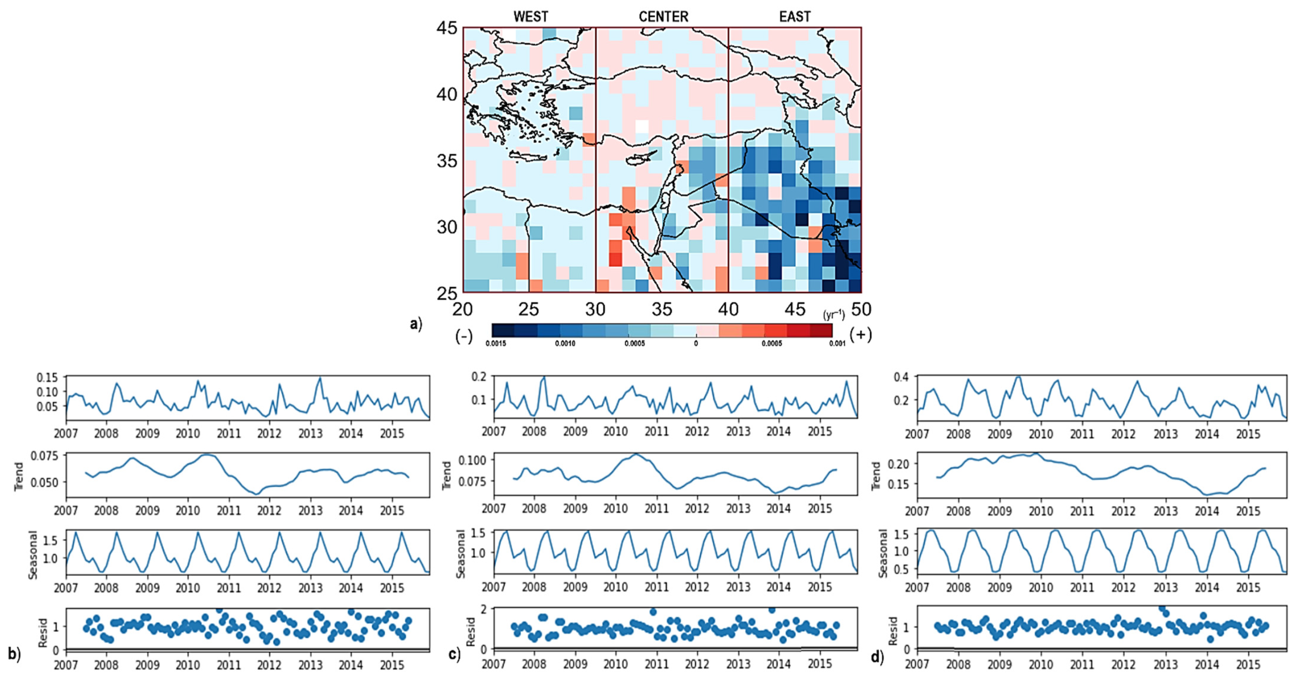
2.4. Trend Decomposition Analysis

Horizontal pure dust data of Western, Central, and Eastern domains were statistically analyzed via seasonal and trend decomposition using Loess (STL) method [103]. This method robustly decomposes a given time series data into the seasonal, trend, and residual components using embedded Loess regression curve smoothing with ordinary least squares polynomial fit. There are six main steps in this method: 1. de-trending; 2. smoothing cycle sub-series; 3. filtering of smoothed cycle sub-series; 4. de-trending of cycle sub-series; 5. de-seasonalizing; and 6. trend smoothing, respectively. At the end of these statistical steps, primary time-series data (Yt) can be decomposed into the seasonal cycle (St), trend-cycle (Tt), and residuals (Rt), as shown in Equation (1) below.
Y t = S t + T t + R t

3. Results and Discussion

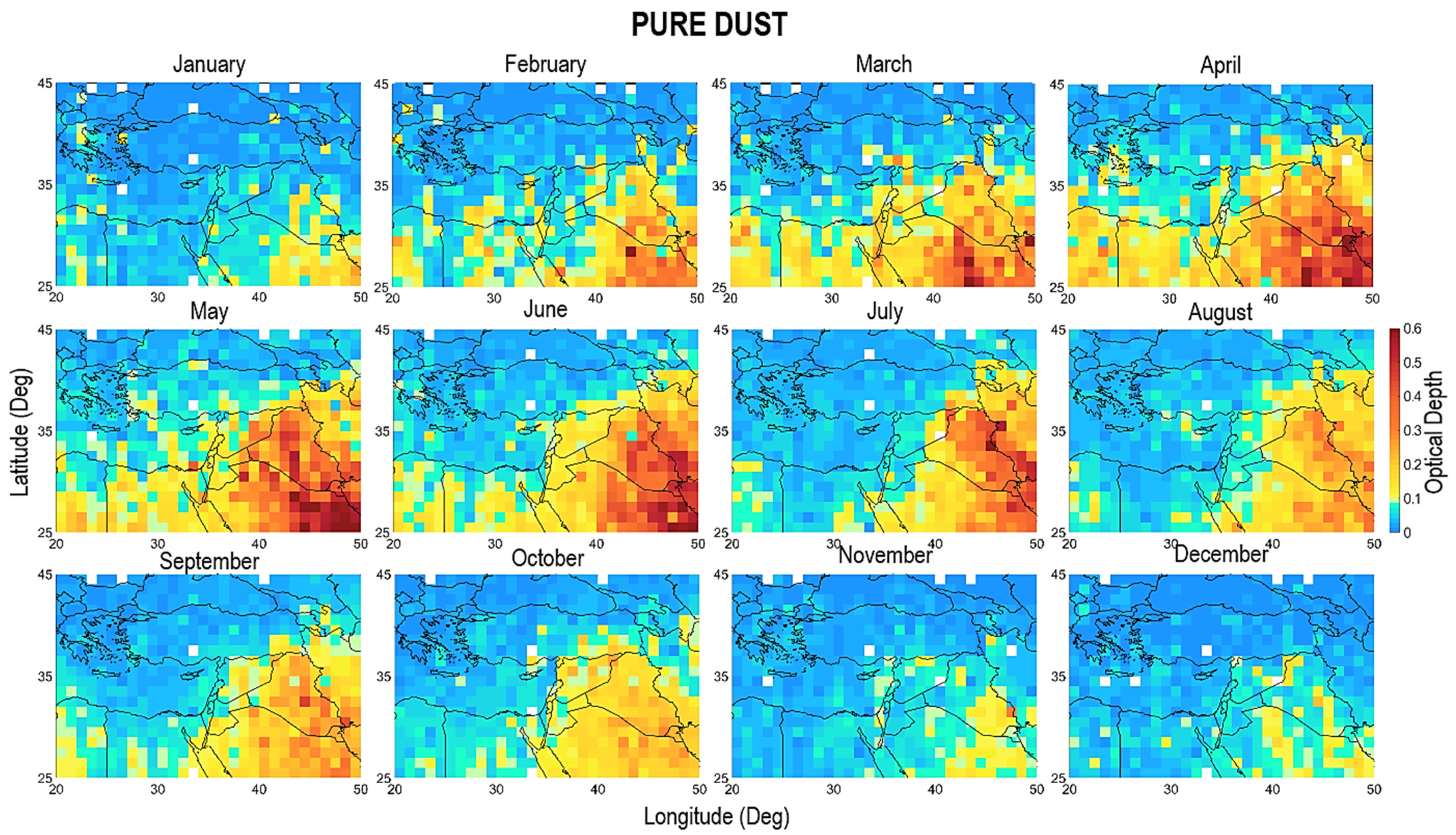
3.1. Horizontal Distributions

In this part of the results section, CALIPSO-derived total, and seasonal mean AOD and pure dust optical depth (DOD) horizontal distributions, are presented for the period between 1 January 2007 and 31 December 2015. Horizontal outputs are plotted with 1° × 1° spatial resolution CALIPSO-derived product for the wider domain (20–50° E and 25–45° N) to indicate climatological distributions. Nine-year AOD and DOD mean values and their ratio are depicted in Figure 2 for the entire time window. As for the total domain, the mean AOD value is 0.20 ± 0.04, significantly increasing in eastern longitudes where the Mediterranean Sea ends, and Middle East desert areas start to exist, extending to the Persian Gulf. A 0.02 AOD value is relatively high, and can be accepted as a sign of a possibly polluted atmosphere. This region includes some of the world’s most crowded cities with settlements, industrial facilities and connection roads (e.g., Athens, İstanbul, and Cairo). Additionally, it spreads to the southeastern shores of the Caspian Sea, together with the eastern part of the Mediterranean Sea and the Black Sea, which reveals anthropogenic and marine contributions to the total aerosol load. Cairo and most parts of the Middle East around the Persian Gulf have the highest AOD values in the region at 0.43 and 0.61, respectively. If we approach the region in terms of desert dust, megacity Cairo [92] differs from the eastern side of the Red Sea with about 60% of possibly anthropogenic and marine aerosols. The Middle East part of the main domain has 70–100% dust abundance in the total aerosol budget. Decreasing values, down to 0.05, can be observed in northern longitudes over the Black Sea, highly forested and mountainous northeastern Anatolia, and the Caucasus region (~3.5–4.5 km), which have endemic flora, fauna and exceptionally high oxygen levels, and a few specific parts of the Aegean Sea and inner Anatolia. The mountainous structure of this territory can also be tracked from the DEM depicted in Figure 1.
The average DOD value for the whole domain is 0.10 ± 0.02, increasing in desert areas with an apparent peak of 0.42 around the Persian Gulf. The mean DOD value over Anatolia is ~0.05, with a significant increase, up to 0.1, in the southeastern border close to source regions at the Middle East. In remote locations such as the Mediterranean Sea shoreline in southeastern Anatolia, the dust pattern seems to be a continued extension of the Middle East sources. The highly industrialized zone of the Marmara and Aegean regions including megacity Istanbul, the southeastern shorelines with numerous large installed capacity thermal power plants and harbors, and the capital Ankara and arid surroundings, indicate the non-dust aerosol contribution to total load. The pure dust to total aerosol ratios of Marmara, Aegean Sea, Mediterranean shoreline regions, and central arid areas are ~20%, ~25%, ~40%, and ~30%, respectively.
It is possible to emphasize anthropogenic aerosols in these areas, including continental dust impact in the central Anatolia basin. As depicted in Figure 1, ridge elevations are lowering on the Aegean and Marmara coasts, and plains are penetrating into inner Anatolia, which carries the marine climate further away from the water body. However, this study does not contain any other aerosol type, and it is possible to emphasize marine aerosol contribution to the Mediterranean and the Black Sea coastlines.
A primary synoptic, seasonal classification in simplest terms as winter (December–January–February–March), spring (April–May), summer (June–July–August–September), and autumn (October–November) was made by Alpert et al. [104]. This classification clarifies the systems carrying dusty winds to the eastern Mediterranean Basin. In the winter wet season, westerlies generated over the Italian Alps dominate the region with high sea surface temperature, causing low troughs and precipitation-blocking Red Sea troughs [105]. Additionally, southwesterly Lodos affects the Aegean Sea environment. In spring, the Khamsin (Sharav) low dominates the region with intense dry heat for about 50 days, as in the meaning of the Arabic word Khamsin. Except for the Khamsin period, the Red Sea trough is normal for this season. In the summer months, during the western branch of the Asian Monsoon, Persian troughs are in effect over Anatolia, reaching Aegean coasts and subtropical highs [106]. Conversely, in Lodos, Etesian (Meltemi) winds reach Egypt from the Aegean Sea [107]. In their classification’s autumn, the Persian trough starts to decay and leaves the region to the Red Sea troughs [104]. According to these synoptically classified seasons, it is evident that dust-carrying winds have arrived over Anatolian land throughout the year.
In this study, out of those synoptic-based seasonal classifications mentioned above, 3-month seasonal grouping for 9-year DOD distributions is organized as November–December–January, February–March–April, May–June–July, and August–September–October, based on monthly mean distributions (108 months, not shown here) and also 9-year monthly mean distributions, as depicted in Appendix A, Figure A1. Seasonal grouping starts with the first observed particular dust transport pattern in February. As solar irradiance increases at the end of the cold–wet months in the eastern Mediterranean basin, dust particles become lofted with the prevailing winds from both the Sahara and Middle East deserts, as shown in Figure A1 and Table 1. According to this seasonal grouping, the ratio of dusty overpasses, DOD, and AOD values of CALIPSO are presented in Appendix A, Figure A2. Based on these maps, it is possible to notice 0% dusty pixels in the Caucasus part in February–March–April and November–December–January seasons. Once the dust particles are suspended from the surface and gain head, they can travel long distances. Additionally, over the mountainous summits of Turkey in the Eastern subdomain, values decrease dramatically by 10%. This drop can be explained by the sudden elevation increase (Figure 1); the high ridges form a natural barrier against dust transport. However, the data are generally of good quality in all seasons, with an average 70% dust occurrence score (Figure A2). There are 100% values naturally observed over the Middle East.
Grids of 1° × 1° confined, and seasonally classified 9-year mean CALIPSO DOD and AOD horizontal distributions are depicted in Figure 3, together with concurrent MODIS AOD distributions. For the same seasonal classification, dust center height (DCH, km) and dust top height (DTH, km) views are depicted in Figure 4. CALIPSO Lidar enables the investigation of aerosol vertical profiles based on the extinction coefficient. In this study, in each dust profile, DCH refers to the height where the dust is most abundant (weighted extinction height), and DTH refers to the height where most of the dust abundance (98% of dust extinction) is located below [108].
Additionally, seasonal summary statistics on AOD, DOD, DCH, and DTH are given in Table 1. Since MODIS quality-ensured atmospheric products are broadly used and mostly validated, it is a good reference point to compare with the CALIPSO-derived products of this study. The same procedure and time window are used for MODIS AOD data as retrieved, geographically confined, and seasonally classified. Correlations between MODIS AOD and CALIPSO DOD and AOD results are very high at 95–97%, except for the Western subdomain. In general, CALIPSO observations tend to have lower values than MODIS, due to the nature of its remote sensing technique. While the passive sensor onboard Aqua has a large swath width (>700 km) over the Earth’s surface, CALIOP has only laser shot points in an orbital row. In the present case, measurement density is inherently low, as it is impossible to note the instantaneous horizontal coverage for the onboard Lidar. This lower measurement density becomes apparent in the Western subdomain. In this region, dust and aerosol abundancy are rare compared with the neighboring and Eastern subdomains. Lower abundancy causes lower AOD, and accordingly, causes a lower correlation with MODIS AOD (89% in West).
At first glance, from Figure 3 and the monthly distributions in corresponding Figure A1, it is possible to classify November–December–January as low, February–March–April as transition, and May–June–July and August–September–October as high dust-affected seasons for Anatolia. Dust patterns increase in February–March–April compared with November–December–January, and decrease in August–September–October relative to May–June–July. Particularly over the Mediterranean shores of North Africa, dust starts to become lofted (Figure 4) and transported to remote locations from the sources due to the prevailing wind characteristics. As the wet season ends, solar energy intensity increases, and the spring transition season begins. In February, dust-carrying Lodos winds begin to gust through upcountry and reach even the Black Sea. However, Lodos winds become storms with an average speed of 80 km/h over the Aegean Sea, Çanakkale (Dardanelles) Strait, Marmara Sea, and Bosporus (İstanbul). Following this, soil moisture and humidity levels decrease over source regions [107], and accordingly, dust particles reach top levels in the troposphere (~6 km), and dust abundance increases to maximum values (~2.5) in the February–March–April season throughout the basin.
Figure 3 and Figure 4, and Table 1 show that the highest season in terms of all parameters is May–June–July. Dust is the significant contributor to total aerosol load in these months, and shows an apparent ascending trend. Parallel to increased mass loading, transport elevations are rising to the summit of the mountain ranges from the Zagros to the Caucasus. From this point of view, transport heights of dust particles are quite different compared with other seasons. The center of the peak mass loading in an atmospheric measurement column, DCH in our case, is elevated parallel to DTH. Accordingly, the gained elevation reveals dust particles overcome the high obstacles of the Taurus, North Anatolian, and Caucasus mountain ranges. Thus, dust plumes reach the most remote places in the back slopes of ridges and tend to dry deposit.
In the August–September–October season, although transport elevations are slightly decreasing compared with May–June–July, lofted particles still have the ability to climb over high ridges. Counter to the February–March–April season, the solar intensity falls from the second half of August. Hot spots over the Middle East and North Africa become smoother in proportion to the previous warm months, and the dust pattern recedes to low latitudes. As the season turns to autumn, precipitation causes particulate matter to scavenge from the atmosphere. Particles faced with high mountain ranges with a decreased vertical head tend to accumulate on the front slopes more than on the back slopes of the summit.
The autumn transition is completed by November and leaves its mission to cold–wet weather conditions. Dry deposition leaves its place in scavenging systems via snow and rainfall. Numerous scientific groups have studied atmospheric dust contribution to CCN and IN formation mechanisms [4,5,6,7,8,9,109]. As November–December–January is defined as the low season, in November, the frequency of Lodos storms becomes lower, but wind speed increases dramatically. The most recent extreme event reached up to 150 km/h over İstanbul. Dust brings precipitation, scavenging drops the dust in the air, and vice versa [110].
Out of monthly synoptic variations, massive oceanic oscillation systems regulate the inter-annual changes in dust fluxes in the atmosphere. The area between the Euphrates and Tigris rivers in the Middle East is called the Fertile Crescent. It is almost wholly a desert without the presence of water. Synergistic effects of the Pacific Decadal Oscillation (PDO) and El Niño Southern Oscillation (ENSO) are mainly responsible for precipitation drops and, accordingly, droughts in the region [107]. It is well known that the North Atlantic Oscillation (NAO) has a significant impact on Saharan dust mobility [111].
Trend decomposition analysis was conducted for 9-year (108 months) pure dust data derived from the CALIPSO product. Analysis results are depicted as a regional (year−1) map and relevant trends in Figure 5. The significance of the analysis results is primarily between 90–95% confidence interval, and seasonally decomposed trends tend to decrease slightly in all three domains. Significantly, there is an increasing pattern after 2007, which is the year most affected by the oscillation dynamics in the Middle East. As the soil moisture descends, dust mobility ascends [111]. It is possible to describe that all three subdomains are matching and nonmatching at certain points. There is a noteworthy peak in the middle of 2010 in the Central and Western subdomains. Before 2010, it is smoother and lower in the Central subdomain compared with the Western and Eastern subdomains. There are two peaks prior to 2012 in the West, but the trend is more continuous and inflated in the East, with a significant peak closer to the beginning of 2011. However, the mass load increases from the west to the east; another critical point is the decrease in 2014,which can be attributed to the increase in precipitation and soil moisture experienced in the same year. The correlation between soil moisture, precipitation, surface wind and AOD in the Middle East is described by Klingmüller et al. [112]. In that study, MODIS–AOD trends were calculated based on two different time windows, 2000–2015 and 2001–2012, respectively. For those periods, it was found that there is a strong increasing trend (within 99% confidence interval) for mainly the Arabian Peninsula, in that study. It should be noted that the total aerosol load may cover all natural and anthropogenic particles for the observed region. This paper calculates the pure dust trends of this eastern Mediterranean domain for the first time, and decreasing trends are mainly located below the southern Turkish border. Parallel findings of sand and dust (SDS) observations reveal a descending lofted dust mass between the southern Turkish border and the northwestern side of the Persian Gulf [113].

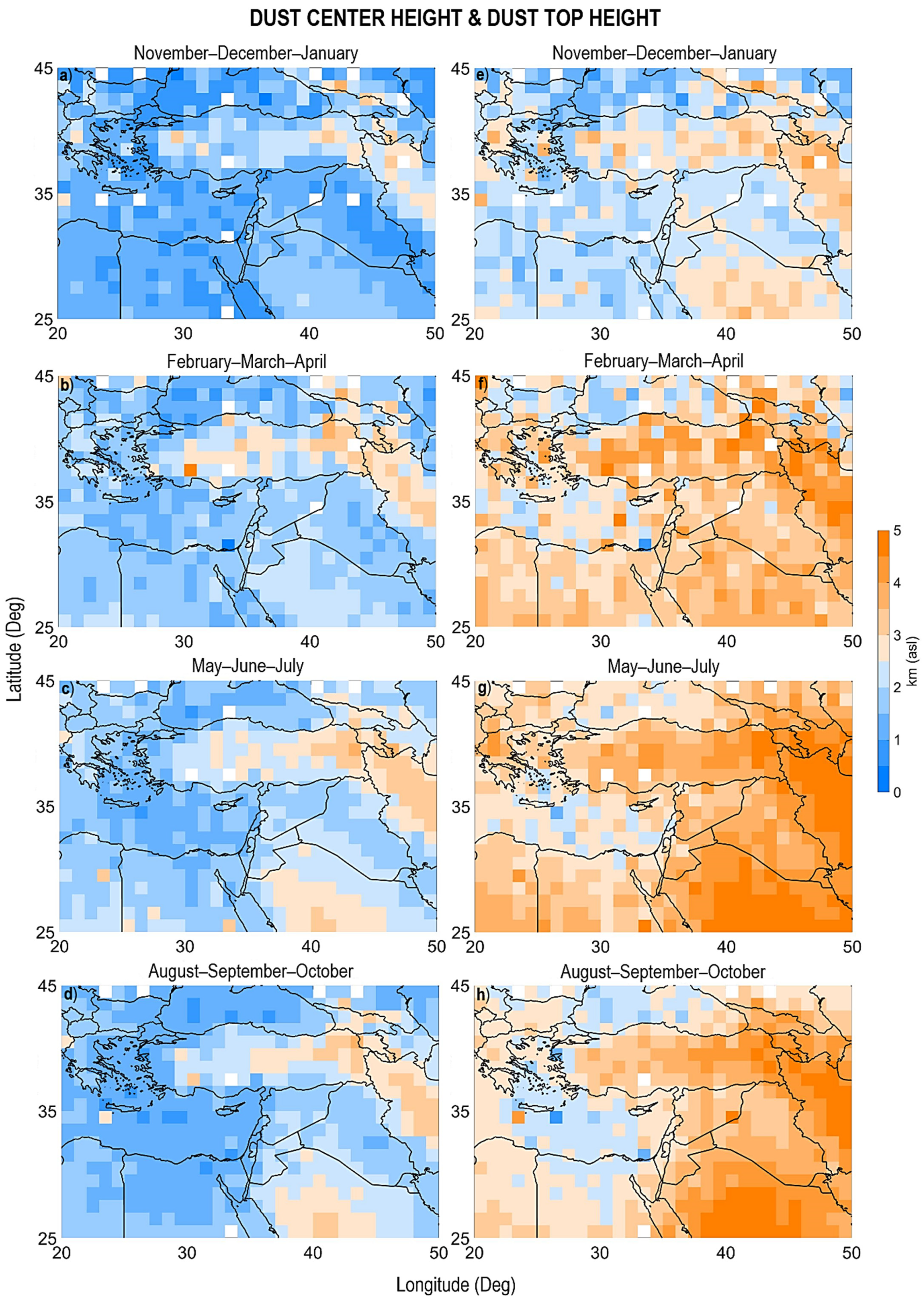
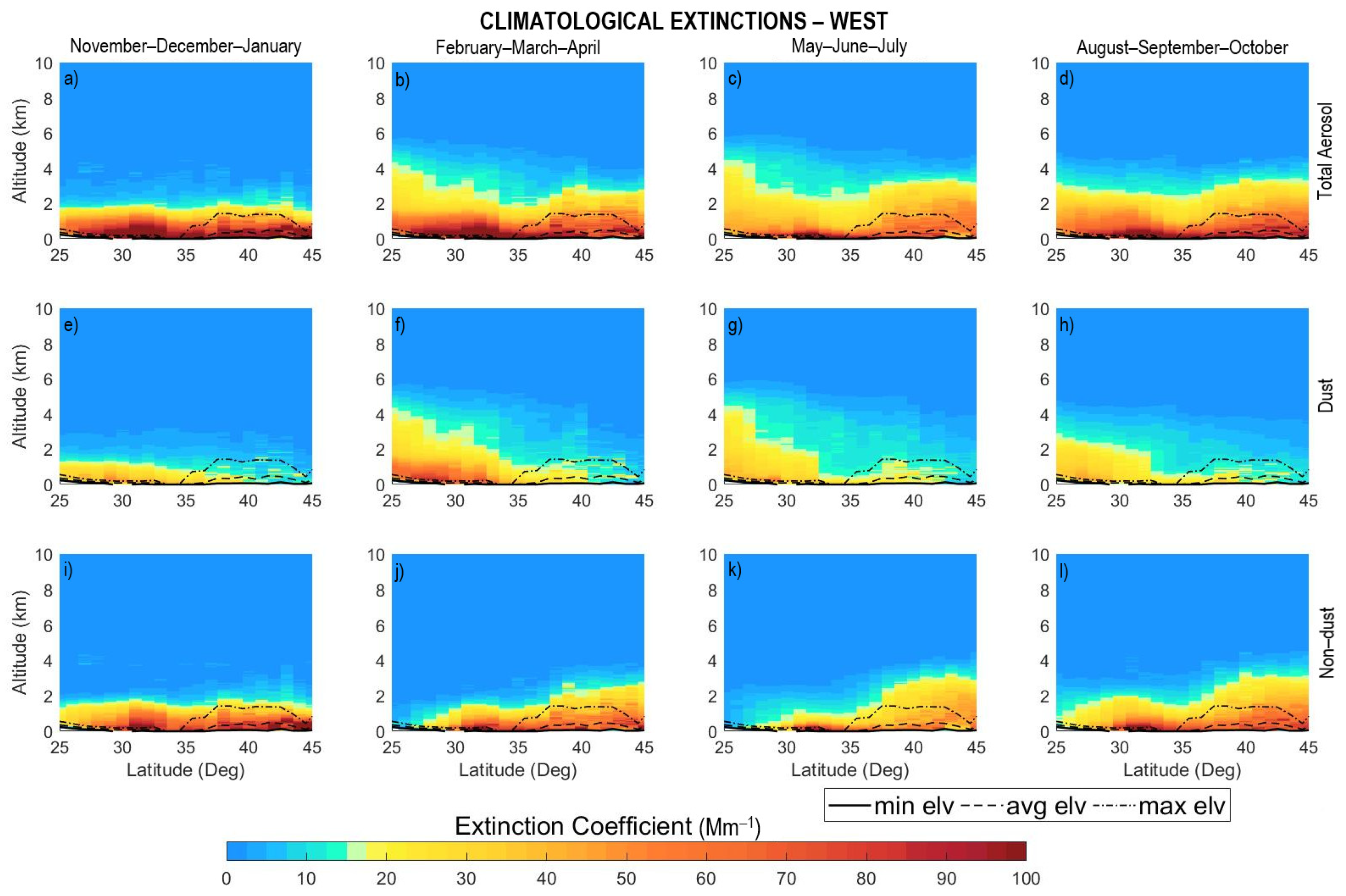
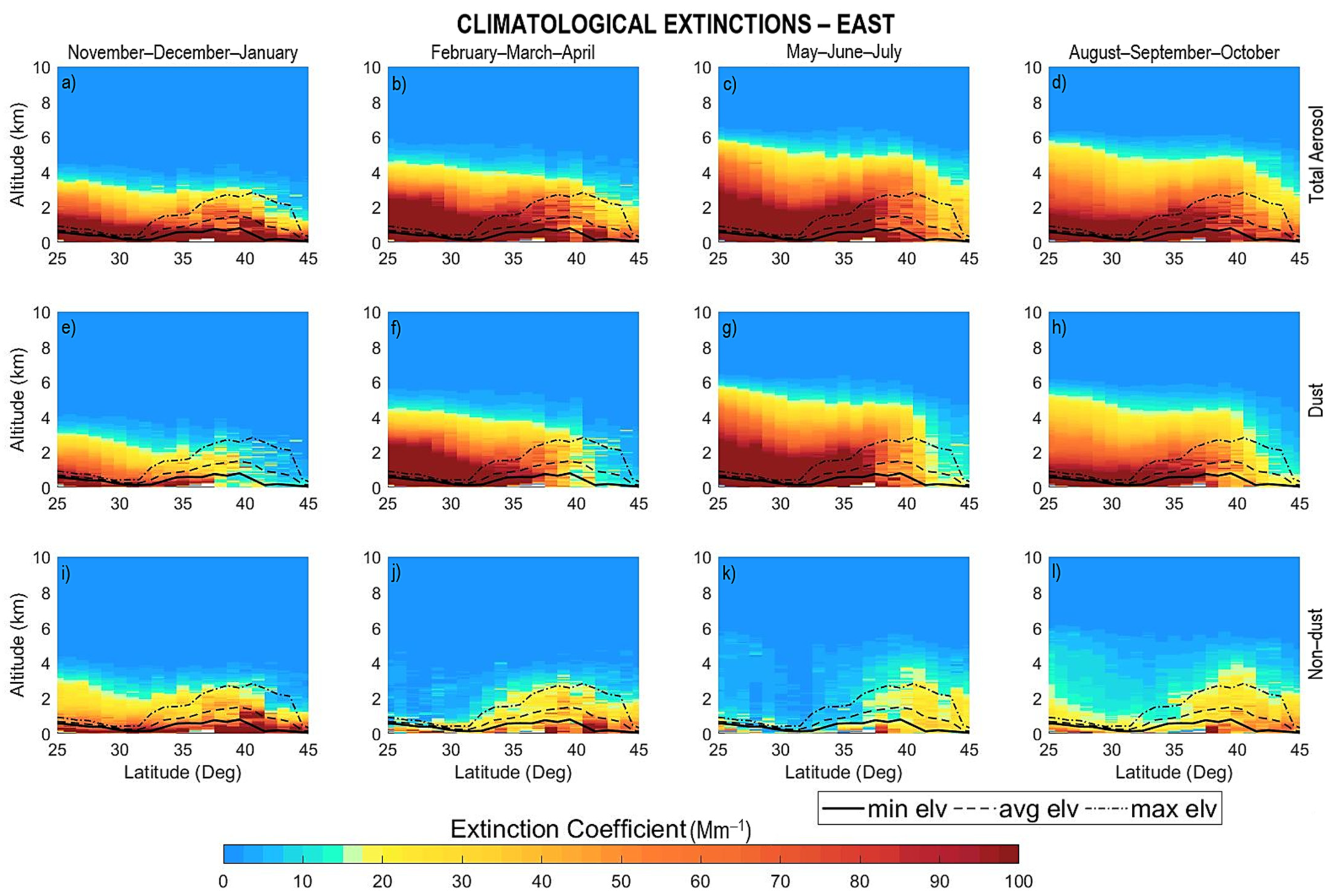
3.2. Vertical Distributions

3.2.1. Climatological Profiles

Climatological k extinction cross sections for total, dust and non-dust aerosols are presented for the three subdomains in this part. Within the broader domain, longitudinal 10° confined subdomains have previously been given in Figure 1. The same seasonal grouping gathers longitudinally averaged vertical profiles up to 10 km above mean sea level. The following cross-sectional maps also include embedded minimum, average, and maximum mean elevation information for the 10° slices.
Horizontal optical depth turns out to be columnar extinction on a vertical basis. From a different point of view, extinction cross-sections of total aerosol, dust and non-dust aerosols were decomposed for the western subdomain between 20–30° E and 25–45° N, and are given in Figure 6. This area includes highly industrialized and densely populated western Anatolia and the eastern part of Europe. Slight depression, namely, source zones in Libya and the significant Qattara region in Egypt, are located herein. The lowest transport elevations and corresponding low values for all types are observed here, considering the other two subdomains, which are also mentioned in horizontal distributions. Lodos occurs in the wet season while Khamsin winds occur in the dry season. Additionally, Khamsin winds are critically responsible for high temperatures and drying soil in the broader eastern Mediterranean Basin. Due to the Lodos and prevailing westerlies gusting through the Aegean Sea up to the northern areas, pure dust values increase in the February–March–April season. The pure dust portion in the total load dramatically increases with the lofted particles from the source regions, becoming evident between 25–35° N until the buoyant particles face the Taurus mountain range barrier. Additionally, by the Persian trough, which is the western part of the Asian Monsoon, transport heights are kept more or less identical in May–June–July, to the previous months. When summer starts to shift to autumn, both elevations and abundance show an attenuated profile converse to the inclining non-dust aerosols between 35–45° N.
Significantly, it is possible to emphasize that from mid to northern latitudes, the non-dust part with a marine portion is specifically dominated by anthropogenic aerosols in total aerosol load. The highest season February–March–April in the Western domain shifts to the summer months as we move to the east. Figure 7 depicts the climatological seasonal vertical dust cross sections for the Central subdomain between 30–40° E and 25–45° N. It covers central Anatolia, the Sinai Peninsula, the Red Sea, and the Middle East countries in the Mediterranean basin. This subdomain has higher values than the Western and is highly connected with those aforementioned dust-carrying synoptic systems. In addition to westerlies and the Khamsin low, the Persian trough and Red Sea trough are more effective. Persian trough shifts peak values effectively to May–June–July and August–September–October seasons. From 35° N latitudes of Anatolia, because of the increasing average elevations with the continuing Taurus system, the abundancy of transported dust increases at ground levels. Accumulation due to the downslope effect leads to air quality degradation on the southern slopes of the seashore. Additionally, other types of aerosol, which can be a mixture of continental and anthropogenic, are highly abundant in the other direction of the downslopes. However, it can be seen that the dust particles could pass through the topographical barrier they encounter and reach mid-Anatolia at ground level. Another crucial barrier against the northern latitudes is that the Black Sea mountain ranges stand between the mainland and the sea.
Climatological seasonal total, dust, and non-dust cross sections for the Eastern subdomain between 40–50° E and 25–45° N are depicted in Figure 8. In addition to 3000 m average elevations, altitude drops dramatically towards the Middle East in the southeastern part of Turkey. Close to the Dead Sea shores, topography changes dramatically to below mean sea level, which reveals depression zones that are probable source regions. A significant part of the Middle East countries and the northern shores of the Persian Gulf is located herein. Large dust source areas are also located in this subdomain, even with a direct continental connection without the buffer of the mountain ranges surrounding the Mediterranean Sea. Southeastern mean sea level planes penetrate the inner parts as the Taurus mountain range edges out to the northern latitudes. It is possible to characterize this region as the most different in terms of general aerosol density, dust density, transport height and topography variance. Even the February–March–April season, which has the lowest intensity, has higher values than the seasons with the highest intensity in other regions. This can be attributed to the northern hemisphere’s dominating wind types on a diagonal axis from the southwest to northeast, which comes from the curvature and the orbital direction of the globe. A wide range of transported dust can meet in the region, whether it is only Saharan or Middle East dust, or a mixture of both. It is known that there is also transport from the desert regions of near Asia, although it is very infrequent [99]. Since the transport heights are very high, the eastern Anatolian mountain ranges do not always form an obstacle against the dust. However, as a second obstacle, the Caucasus mountains do not allow dust to pass to higher latitudes. May–June–July and August–September–October seasons show similarities in dust heights, but in terms of intensity, February–March–April and May–June–July seasons are more similar at lower altitudes. Non-dust intensity at lower altitudes increases in November–December–January, most probably due to heating purposes for this mountainous region. It is possible to interpret local, continental dust contribution to deforested areas. In some cases, dust devils and haboobs can be experienced in the southern areas of Turkey [114], just as in the great arid plains in Central Anatolia.

3.2.2. Conditional Profiles

In the latest cross-section part, seasonal conditional extinction profiles of pure dust for three subdomains are depicted in Figure 9. Conditional is the term used to explain the incidence of dust transport cases. It is observed that November, December and January are the most stable and least intense months throughout the eastern Mediterranean Basin. February, March and April are the dominant months for the Center and the West. It can be noted from the profiles that the incidence of dust transport events becomes higher and higher as the location shifts from west to east (avg 100 Mm−1; max ~200 Mm−1). Obviously, the most intense region in terms of frequency and mass is the eastern part of Turkey, especially the eastern Mediterranean basin. In fact, there are some low-intensity months in a year, and it would not be wrong to express that Turkey, with all its regions, is under the effect of long-range transported desert originated particle load for the whole year.

4. Conclusions

Turkey is located between North African, Middle Eastern and Asian deserts, the so-called Dusty Belt, which leads to year-round exposure of transported particulate matter emissions. When considering Turkey’s and the neighboring regions’ intrinsic topographical structure and elevation characteristics, it is possible to emphasize the impact of the natural barriers of mountain ranges and wet deposition dynamics of the spring and autumn months. If lofted particles overcome these high ridges, or are not imposed on deposition mechanisms, they can be found at the ground level of the inner areas. This natural pollution phenomenon mainly affects the ambient air of rural and urban areas and correlatively biotic and abiotic environments. When Turkey’s commitments are considered in air quality amendment actions, natural contribution to the total particulate matter load should be proven with universal consent scientific techniques. The obtained results of this study on spatiotemporal 3D variations of dust aerosols over the region will shed light on further climate, air quality, and public health studies.
Mainly, desert dust abundancy increases in the west to east direction with prevailing and local wind systems. Moreover, synoptic-scale air movements in the region reveal seasonal variability. February is the first dust intrusion observed month, starting seasonal grouping in this study. November, December and January are the most stable and low mass case incidence months of the year. February, March and April are the highest months for Western and Central regions. The Eastern region is the most intense in terms of frequency and mass abundance, compared with the others. There is also a high season shift from spring to summer and autumn months. The seasonal grouping composed of May, June, and July months is the most active period, as all subdomains have the highest dust elevations, incidences, and mass loads. Oceanic oscillation systems such as ENSO, PDO, and NAO are synergistically effective in the eastern Mediterranean basin from inter-annual variability. Although all subdomains tend to have decreased trends, the Eastern subdomain still has the highest values close to ground level. The mountainous structure of Turkey is a natural buffer that disables particles in reaching inner parts and northern latitudes. Meanwhile, it enables air quality degradation near southern slopes with downwelling accumulative effects.
To the authors’ best knowledge, this study specifies pure dust and total aerosol climatology for Turkey. Three-dimensional spatiotemporal dust abundance outputs can be used solely, or in combination with, other remote sensing and in situ techniques to better explain dust, aerosol, and cloud interactions. Additionally, this study offers a different perspective and background information for policymakers, in order to sustain environmental management, public services and early warning systems.

Author Contributions

Conceptualization, V.A., G.G. and S.Y.A.; methodology, S.Y.A. and E.P.; software S.Y.A.; validation, S.Y.A. and E.P.; formal analysis, S.Y.A.; investigation, S.Y.A.; resources, V.A.; data curation, S.Y.A., A.G. and E.P.; writing—original draft preparation, S.Y.A.; writing—review and editing, S.Y.A., G.G., V.A., A.G. and E.P.; visualization, S.Y.A.; supervision, V.A. and G.G.; project administration, S.Y.A.; funding acquisition, S.Y.A. All authors have read and agreed to the published version of the manuscript.

Funding

The first author was funded by The Scientific and Research Council of Turkey (TUBITAK) via the 2214-A International Doctoral Research Fellowship Programme, grant agreement no: #1059B141600252. The study was funded by Hacettepe University, Scientific Research Projects Coordination Unit, project no: #FKA-2016-12935. Amiridis, V. and Proestakis, E. were supported by the D-TECT project funded by the European Research Council (ERC), under the European Union’s Horizon 2020 Research and Innovation Programme, grant agreement no: 725698. Gkikas, A. was supported by the Hellenic Foundation for Research and Innovation (H.F.R.I.) under the “2nd Call for H.F.R.I. Research Projects to support Post-Doctoral Researchers” (project acronym: ATLANTAS, project number: 544).

Data Availability Statement

The LIVAS database is publicly available at http://lidar.space.noa.gr:8080/livas/ accessed on 1 April 2022. LIVAS EARLINET-optimized pure dust products are available upon request from Vassilis Amiridis ([email protected]). CALIPSO data provided by NASA, which was obtained from the ICARE Data and Services Center online archive, is available at http://www.icare.univ-lille1.fr/archive accessed on 1 April 2022 (CALIPSO Science Team, 2015; ICARE Data Center, 2017). MODIS data is publicly available at NASA Atmosphere Archive and Distribution System (LAADS) website (https://ladsweb.modaps.eosdis.nasa.gov/ accessed on 1 April 2022) via Distributed Active Archive Center (DAAC).

Acknowledgments

This publication is a part of the first author’s doctoral dissertation. Special thanks to Hatice Öncel Çekim for help on statistical analysis.

Conflicts of Interest

The authors declare no conflict of interest. The funders had no role in the design of the study; in the collection, analyses, or interpretation of data; in the writing of the manuscript, or in the decision to publish the results.

Appendix A

Figure A1. Nine-year CALIPSO-derived monthly pure dust distributions.
Atmosphere 13 00733 g0a1
Figure A2. Nine-year seasonally classified used scenes of CALIPSO dusty overpasses (%) with corresponding pure dust and total aerosol horizontal distributions.
Atmosphere 13 00733 g0a2

References

  1. Jacobson, M.Z. Global Direct Radiative Forcing Due to Multicomponent Anthropogenic and Natural Aerosols. J. Geophys. Res. Atmos. 2001, 106, 1551–1568. [Google Scholar] [CrossRef]
  2. Stocker, T.F.; Qin, D.; Plattner, G.K.; Tignor, M.M.B.; Allen, S.K.; Boschung, J.; Nauels, A.; Xia, Y.; Bex, V.; Midgley, P.M. Climate Change 2013 the Physical Science Basis: Working Group I Contribution to the Fifth Assessment Report of the Intergovernmental Panel on Climate Change; Cambridge University Press: Cambridge, UK, 2013. [Google Scholar] [CrossRef] [Green Version]
  3. Lelieveld, J. Global Air Pollution Crossroads over the Mediterranean. Science 2002, 298, 794–799. [Google Scholar] [CrossRef] [PubMed] [Green Version]
  4. Jickells, T.D.; Baker, A.R.; Brooks, N.; Liss, P.S.; An, Z.S.; Cao, J.J.; Andersen, K.K.; Bergametti, C.; Boyd, P.W.; Hunter, K.A.; et al. Global Iron Connections between Desert Dust, Ocean Biogeochemistry, and Climate. Science 2005, 308, 67–71. [Google Scholar] [CrossRef] [PubMed] [Green Version]
  5. Saltzman, E.S.; Dioumaeva, I.; Finley, B.D. Glacial/Interglacial Variations in Methanesulfonate (MSA) in the Siple Dome Ice Core, West Antarctica. Geophys. Res. Lett. 2006, 33, 1–4. [Google Scholar] [CrossRef] [Green Version]
  6. Rosenfeld, D.; Lohmann, U.; Raga, G.B.; O’Dowd, C.D.; Kulmala, M.; Reissell, A.; Fuzzi, S.; Andreae, M.O. Flood or Drought: How Do Aerosols Affect Precipitation? Science 2008, 321, 1309–1313. [Google Scholar] [CrossRef] [Green Version]
  7. Ridley, D.A.; Heald, C.L.; Ford, B. North African Dust Export and Deposition: A Satellite and Model Perspective. J. Geophys. Res. Atmos. 2012, 117, 1–21. [Google Scholar] [CrossRef]
  8. Yu, H.; Chin, M.; Yuan, T.; Bian, H.; Remer, L.A.; Prospero, J.M.; Omar, A.; Winker, D.; Yang, Y.; Zhang, Y.; et al. The Fertilizing Role of African Dust in the Amazon Rainforest: A First Multiyear Assessment Based on CALIPSO Lidar Observations. Geophys. Res. Lett. 2015, 42, 1984–1991. [Google Scholar] [CrossRef]
  9. Nickovic, S.; Vukovic, A.; Vujadinovic, M.; Djurdjevic, V.; Pejanovic, G. Technical Note: High-Resolution Mineralogical Database of Dust-Productive Soils for Atmospheric Dust Modeling. Atmos. Chem. Phys. 2012, 12, 845–855. [Google Scholar] [CrossRef] [Green Version]
  10. Kim, J.J.; Smorodinsky, S.; Lipsett, M.; Singer, B.C.; Hodgson, A.T.; Ostro, B. Traffic-Related Air Pollution near Busy Roads: The East Bay Children’s Respiratory Health Study. Am. J. Respir. Crit. Care Med. 2004, 170, 520–526. [Google Scholar] [CrossRef] [Green Version]
  11. Filleul, L.; Rondeau, V.; Vandentorren, S.; Le Moual, N.; Cantagrel, A.; Annesi-Maesano, I.; Charpin, D.; Declercq, C.; Neukirch, F.; Paris, C.; et al. Twenty Five Year Mortality and Air Pollution: Results from the French PAARC Survey. Occup. Environ. Med. 2005, 62, 453–460. [Google Scholar] [CrossRef] [Green Version]
  12. Gauderman, W.J.; Avol, E.; Lurmann, F.; Kuenzli, N.; Gilliland, F.; Peters, J.; McConnell, R. Childhood Asthma and Exposure to Traffic and Nitrogen Dioxide. Epidemiology 2005, 16, 737–743. [Google Scholar] [CrossRef] [PubMed]
  13. Beelen, R.; Hoek, G.; van den Brandt, P.A.; Goldbohm, R.A.; Fischer, P.; Schouten, L.J.; Jerrett, M.; Hughes, E.; Armstrong, B.; Brunekreef, B. Long-Term Effects of Traffic-Related Air Pollution on Mortality in a Dutch Cohort (NLCS-AIR Study). Environ. Health Perspect. 2008, 116, 196–202. [Google Scholar] [CrossRef] [PubMed]
  14. Brauer, M.; Lencar, C.; Tamburic, L.; Koehoorn, M.; Demers, P.; Karr, C. A Cohort Study of Traffic-Related Air Pollution Impacts on Birth Outcomes. Environ. Health Perspect. 2008, 116, 680–686. [Google Scholar] [CrossRef] [Green Version]
  15. Querol, X.; Alastuey, a.; Pey, J.; Cusack, M.; Pérez, N.; Mihalopoulos, N.; Theodosi, C.; Gerasopoulos, E.; Kubilay, N.; Koçak, M. Variability in Regional Background Aerosols within the Mediterranean. Atmos. Chem. Phys. 2009, 9, 10153–10192. [Google Scholar] [CrossRef] [Green Version]
  16. Stefanski, R.; Sivakumar, M.V.K. Impacts of Sand and Dust Storms on Agriculture and Potential Agricultural Applications of a SDSWS. In Proceedings of the WMO/GEO Expert Meeting on an International Sand and Dust Storm Warning System OP Conference. Series: Earth and Environmental Science, Barcelona, Spain, 7–9 November 2007; Volume 7. [Google Scholar] [CrossRef]
  17. Griffin, D.W.; Kubilay, N.; Koçak, M.; Gray, M.A.; Borden, T.C.; Shinn, E.A. Airborne Desert Dust and Aeromicrobiology over the Turkish Mediterranean Coastline. Atmos. Environ. 2007, 41, 4050–4062. [Google Scholar] [CrossRef]
  18. Goudie, A.S. Desert Dust and Human Health Disorders. Environ. Int. 2013, 63, 101–113. [Google Scholar] [CrossRef] [PubMed]
  19. NA-ME-E. Northern Africa-Middle East-Europe Regional Center, Sand and Dust Storm Warning Advisory System. Available online: https://sds-was.aemet.es/ (accessed on 15 May 2020).
  20. Union Pacific CAFÉ. Directive 2008/50/EC of the European Parliament and of the Council of 21 May 2008 on Ambient Air Quality and Cleaner Air for Europe. Off. J. Eur. Union 2008. Available online: http://eur-lex.europa.eu/LexUriServ/LexUriServ.do?uri=OJ:L:2008:152:0001:0044:EN:PDF (accessed on 1 April 2022).
  21. EEA. Particulate Matter from Natural Sources and Related Reporting under the EU Air Quality Directive; Technical Report; EEA: Copenhagen, Denmark, 2012. [Google Scholar]
  22. Isaelevich, P.L.; Ganor, E.; Levin, Z.; Joseph, J.H. Annual variations of physical properties of desert dust over Israel. J. Geophys. Res. Atmos. 2003, 108, 4381. [Google Scholar] [CrossRef] [Green Version]
  23. Kubilay, N.; Cokacar, T.; Oguz, T. Optical Properties of Mineral Dust Outbreaks over the Northeastern Mediterranean. J. Geophys. Res. Atmos. 2003, 108, 4666. [Google Scholar] [CrossRef]
  24. Kubilay, N.; Oguz, T.; Koçak, M.; Torres, O. Ground-Based Assessment of Total Ozone Mapping Spectrometer (TOMS) Data for Dust Transport over the Northeastern Mediterranean. Glob. Biogeochem. Cycles 2005, 19, 1–9. [Google Scholar] [CrossRef]
  25. Kalivitis, N.; Gerasopoulos, E.; Vrekoussis, M.; Kouvarakis, G.; Kubilay, N.; Hatzianastassiou, N.; Vardavas, I.; Mihalopoulos, N. Dust Transport over the Eastern Mediterranean Derived from Total Ozone Mapping Spectrometer, Aerosol Robotic Network, and Surface Measurements. J. Geophys. Res. Atmos. 2007, 112, 1–9. [Google Scholar] [CrossRef] [Green Version]
  26. Agacayak, T.; Kindap, T.; Unal, A.; Pozzoli, L.; Mallet, M.; Solmon, F. A Case Study for Saharan Dust Transport over Turkey via RegCM4.1 Model. Atmos. Res. 2015, 153, 392–403. [Google Scholar] [CrossRef]
  27. EARLINET. European Aerosol Research Lidar Network. Available online: https://www.earlinet.org/index.php?id=earlinet_homepage (accessed on 11 March 2017).
  28. MPLNET. The NASA Micro-Pulse Lidar Network. Available online: https://mplnet.gsfc.nasa.gov/ (accessed on 12 March 2017).
  29. Amiridis, V.; Balis, D.S.; Kazadzis, S.; Bais, A.; Giannakaki, E.; Papayannis, A.; Zerefos, C. Four-Year Aerosol Observations with a Raman Lidar at Thessaloniki, Greece, in the Framework of European Aerosol Research Lidar Network (EARLINET). J. Geophys. Res. Atmos. 2005, 110, 1–12. [Google Scholar] [CrossRef] [Green Version]
  30. Hansell, R.A.; Liou, K.N.; Ou, S.C.; Tsay, S.C.; Ji, Q.; Reid, J.S. Remote Sensing of Mineral Dust Aerosol Using AERI during the UAE2: A Modeling and Sensitivty Study. J. Geophys. Res. Atmos. 2008, 113, 1–18. [Google Scholar] [CrossRef]
  31. Papayannis, A.; Amiridis, V.; Mona, L.; Tsaknakis, G.; Balis, D.; Bösenberg, J.; Chaikovski, A.; De Tomasi, F.; Grigorov, I.; Mattis, I.; et al. Systematic Lidar Observations of Saharan Dust over Europe in the Frame of EARLINET (2000–2002). J. Geophys. Res. Atmos. 2008, 113, D10204. [Google Scholar] [CrossRef] [Green Version]
  32. Mona, L.; Liu, Z.; Müller, D.; Omar, A.; Papayannis, A.; Pappalardo, G.; Sugimoto, N.; Vaughan, M. Lidar Measurements for Desert Dust Characterization: An Overview. Adv. Meteorol. 2012, 2012, 356265. [Google Scholar] [CrossRef]
  33. Di Biagio, C.; Formenti, P.; Balkanski, Y.; Caponi, L.; Cazaunau, M.; Pangui, E.; Journet, E.; Nowak, S.; Caquineau, S.; Andreae, O.M.; et al. Global Scale Variability of the Mineral Dust Long-Wave Refractive Index: A New Dataset of in Situ Measurements for Climate Modeling and Remote Sensing. Atmos. Chem. Phys. 2017, 17, 1901–1929. [Google Scholar] [CrossRef] [Green Version]
  34. Nisantzi, A.; Mamouri, R.E.; Ansmann, A.; Schuster, G.L.; Hadjimitsis, D.G. Middle East versus Saharan Dust Extinction-to-Backscatter Ratios. Atmos. Chem. Phys. 2015, 15, 7071–7084. [Google Scholar] [CrossRef] [Green Version]
  35. Sifakis, N.I.; Iossifidis, C.; Kontoes, C. CHRISTINE Code for High ResolutIon Satellite Mapping of Optical ThIckness and ÅNgstrom Exponent. Part II: First Application to the Urban Area of Athens, Greece and Comparison to Results from Previous Contrast-Reduction Codes. Comput. Geosci. 2014, 62, 142–149. [Google Scholar] [CrossRef]
  36. Kubilay, N.; Nickovic, S.; Moulin, C.; Dulac, F. An Illustration of the Transport and Deposition of Mineral Dust onto the Eastern Mediterranean. Atmos. Environ. 2000, 34, 1293–1303. [Google Scholar] [CrossRef]
  37. Moulin, C.; Dulac, F.; Lambert, C.E.; Chazette, P.; Jakowiak, I.; Chatenet, B.; Lavenu, F. Long-Term Daily Monitoring of Saharan Dust Load over Ocean Using Meteosat ISCCP-B2 Data. 2. Accuracy of the Method and Validation Using Sun Photometer Measurements. J. Geophys. Res. 1997, 102, 16959–16969. [Google Scholar] [CrossRef] [Green Version]
  38. Nabat, P.; Somot, S.; Mallet, M.; Chiapello, I.; Morcrette, J.J.; Solmon, F.; Szopa, S.; Dulac, F.; Collins, W.; Ghan, S.; et al. A 4-D Climatology (1979–2009) of the Monthly Tropospheric Aerosol Optical Depth Distribution over the Mediterranean Region from a Comparative Evaluation and Blending of Remote Sensing and Model Products. Atmos. Meas. Tech. 2013, 6, 1287–1314. [Google Scholar] [CrossRef] [Green Version]
  39. Hatzianastassiou, N.; Gkikas, A.; Mihalopoulos, N.; Torres, O.; Katsoulis, B.D. Natural versus Anthropogenic Aerosols in the Eastern Mediterranean Basin Derived from Multiyear TOMS and MODIS Satellite Data. J. Geophys. Res. Atmos. 2009, 114. [Google Scholar] [CrossRef]
  40. Özsoy, E.; Kubilay, N.; Nickovic, S.; Moulin, C. A Hemispheric Dust Storm Affecting the Atlantic and Mediterranean in April 1994: Analyses, Modeling, Ground-Based Measurements and Satellite Observations. J. Geophys. Res. 2001, 106, 18439–18460. [Google Scholar] [CrossRef] [Green Version]
  41. Koren, I.; Joseph, J.H.; Israelevich, P. Detection of dust plumes and their sources in northeastern Libya. Can. J. Remote Sens. 2003, 29, 792–796. [Google Scholar] [CrossRef]
  42. Marey, H.S.; Gille, J.C.; El-Askary, H.M.; Shalaby, E.A.; El-Raey, M.E. Aerosol climatology over Nile Delta based on MODIS, MISR and OMI satellite data. Atmos. Chem. Phys. 2011, 11, 10637–10648. [Google Scholar] [CrossRef] [Green Version]
  43. Alfaro-Contreras, R.; Zhang, J.; Reid, J.S.; Christopher, S. A Study of the Longer Term Variation of Aerosol Optical Thickness and Direct Shortwave Aerosol Radiative Effect Trends Using MODIS and CERES. Atmos. Chem. Phys. Discuss. 2017, 1–63. [Google Scholar] [CrossRef] [Green Version]
  44. Benas, N.; Beloconi, A.; Chrysoulakis, N. Estimation of Urban PM10 Concentration, Based on MODIS and MERIS/AATSR Synergistic Observations. Atmos. Environ. 2013, 79, 448–454. [Google Scholar] [CrossRef]
  45. Gkikas, A.; Hatzianastassiou, N.; Mihalopoulos, N.; Torres, O. Characterization of Aerosol Episodes in the Greater Mediterranean Sea Area from Satellite Observations (2000–2007). Atmos. Environ. 2016, 128, 286–304. [Google Scholar] [CrossRef]
  46. Russell, P.B.; Kacenelenbogen, M.; Livingston, J.M.; Hasekamp, O.P.; Burton, S.P.; Schuster, G.L.; Johnson, M.S.; Knobelspiesse, K.D.; Redemann, J.; Ramachandran, S.; et al. A Multiparameter Aerosol Classification Method and Its Application to Retrievals from Spaceborne Polarimetry. J. Geophys. Res. Atmos. 2014, 119, 9838–9863. [Google Scholar] [CrossRef]
  47. Winker, D.M.; Vaughan, M.A.; Omar, A.; Hu, Y.; Powell, K.A.; Liu, Z.; Hunt, W.H.; Young, S.A. Overview of the CALIPSO Mission and CALIOP Data Processing Algorithms. J. Atmos. Ocean. Technol. 2009, 26, 2310–2323. [Google Scholar] [CrossRef]
  48. Omar, A.H.; Winker, D.M.; Kittaka, C.; Vaughan, M.A.; Liu, Z.; Hu, Y.; Trepte, C.R.; Rogers, R.R.; Ferrare, R.A.; Lee, K.P.; et al. The CALIPSO Automated Aerosol Classification and Lidar Ratio Selection Algorithm. J. Atmos. Ocean. Technol. 2009, 26, 1994–2014. [Google Scholar] [CrossRef]
  49. Kim, M.-H.; Omar, A.H.; Tackett, J.L.; Vaughan, M.A.; Winker, D.M.; Trepte, C.R.; Hu, Y.; Liu, Z.; Poole, L.R.; Pitts, M.C.; et al. The CALIPSO version 4 automated aerosol classification and lidar ratio selection algorithm. Atmos. Meas. Tech. 2018, 11, 6107–6135. [Google Scholar] [CrossRef] [PubMed] [Green Version]
  50. Tesche, M.; Ansmann, A.; Mueller, D.; Althausen, D.; Engelmann, R.; Freudenthaler, V.; Gross, S. Vertically resolved separation of dust and smoke over Cape Verde using multiwavelength Raman and polarization lidars during Saharan Mineral Dust Experiment 2008. J. Geophys. Res. Atmos. 2009, 114, D13202. [Google Scholar] [CrossRef]
  51. Tackett, J.L.; Winker, D.M.; Getzewich, B.J.; Vaughan, M.A.; Young, S.A.; Kar, J. CALIPSO lidar level 3 aerosol profile product: Version 3 algorithm design. Atmos. Meas. Tech. 2018, 11, 4129–4152. [Google Scholar] [CrossRef] [Green Version]
  52. Yorks, J.E.; McGill, M.; Rodier, S.; Vaughan, M.; Hu, Y.; Hlavka, D. Radiative Effects of African Dust and Smoke Observed from Clouds and the Earth’s Radiant Energy System (CERES) and Cloud-Aerosol Lidar with Orthogonal Polarization (CALIOP) Data. J. Geophys. Res. Atmos. 2009, 114, 1–10. [Google Scholar] [CrossRef]
  53. Kabatas, B.; Unal, A.; Pierce, R.B.; Kindap, T.; Pozzoli, L. The Contribution of Saharan Dust in PM10 Concentration Levels in Anatolian Peninsula of Turkey. Sci. Total Environ. 2014, 488–489, 413–421. [Google Scholar] [CrossRef]
  54. Mamouri, R.E.; Ansmann, A. Estimated Desert-Dust Ice Nuclei Profiles from Polarization Lidar: Methodology and Case Studies. Atmos. Chem. Phys. 2015, 15, 3463–3477. [Google Scholar] [CrossRef] [Green Version]
  55. Li, J.; Han, Z. Aerosol Vertical Distribution over East China from RIEMS-Chem Simulation in Comparison with CALIPSO Measurements. Atmos. Environ. 2016, 143, 177–189. [Google Scholar] [CrossRef]
  56. Liu, D.; Wang, Z.; Liu, Z.; Winker, D.; Trepte, C. A height resolved global view of dust aerosols from the first year CALIPSO lidar measurements. J. Geophys. Res. Atmos. 2008, 113, 1–15. [Google Scholar] [CrossRef]
  57. Winker, D.M.; Pelon, J.; Coakley., J.A., Jr.; Ackerman, S.A.; Charlson, R.J.; Colarco, P.R.; Flamant, P.; Fu, Q.; Hoff, R.; Kittaka, C.; et al. The CALIPSO mission: A global 3D view of aerosols and clouds. Bull. Amer. Meteor. Soc. 2010, 91, 1211–1229. [Google Scholar] [CrossRef]
  58. Winker, D.M.; Tackett, J.L.; Getzewich, B.J.; Liu, Z.; Vaughan, M.A.; Rogers, R.R. The Global 3-D Distribution of Tropospheric Aerosols as Characterized by CALIOP. Atmos. Chem. Phys. 2013, 13, 3345–3361. [Google Scholar] [CrossRef] [Green Version]
  59. Giorgi, F. Climate Change Hot-Spots. Geophys. Res. Lett. 2006, 33, L08707. [Google Scholar] [CrossRef]
  60. Giorgi, F.; Lionello, P. Climate change projections for the Mediterranean region. Global Planet. Chang. 2008, 200863, 90–104. [Google Scholar] [CrossRef]
  61. Lelieveld, J.; Hadjinicolaou, P.; Kostopoulou, E.; Chenoweth, J.; El Maayar, M.; Giannakopoulos, C.; Hannides, C.; Lange, M.A.; Tanarhte, M.; Tyrlis, E.; et al. Climate change and impacts in the Eastern Mediterranean and the Middle East. Clim. Chang. 2012, 114, 667–687. [Google Scholar] [CrossRef] [PubMed] [Green Version]
  62. Kubilay, N.; Saydam, A.C. Trace Elements in Atmospheric Particulates over the Eastern Mediterranean; Concentrations, Sources, and Temporal Variability. Atmos. Environ. 1995, 29, 2289–2300. [Google Scholar] [CrossRef]
  63. Al-Momani, I.F.; Güllü, G.; Ölmez, I.; Eler, Ü.; Örtel, E.; Sirin, G.; Tuncel, G. Chemical Composition of Eastern Mediterranean Aerosol and Precipitation: Indications of Long-Range Transport. Pure Appl. Chem. 1997, 69, 41–46. [Google Scholar] [CrossRef]
  64. Güllü, G.H.; Ölmez, I.; Aygün, S.; Tuncel, G. Atmospheric Trace Element Concentrations over the Eastern Mediterranean Sea: Factors Affecting Temporal Variability. J. Geophys. Res. 1998, 103, 21943. [Google Scholar] [CrossRef]
  65. Holben, B.N.; Slutsker, T.I.E.I.; Tar, D.; Buis, J.P.; Setxerj, I.I.A.; Reagan, A.; Kaufman, J.Y.; Nakajima, T.; Lavenu, F.; Vemte, E.; et al. AERONET-A Federated Instrument Network and Data Archive for Aerosol Characterization. Remote Sens. Environ. 1998, 66, 1–16. [Google Scholar] [CrossRef]
  66. AERONET. Aerosol Robotic Network. Available online: https://aeronet.gsfc.nasa.gov/ (accessed on 22 January 2022).
  67. Doǧan, G.; Güllü, G.; Tuncel, G. Sources and Source Regions Effecting the Aerosol Composition of the Eastern Mediterranean. Microchem. J. 2008, 88, 142–149. [Google Scholar] [CrossRef]
  68. Gullu, G.; Olmez, I.; Tuncel, G. Source Apportionment of Trace Elements in the Eastern Mediterranean Atmosphere. J. Radioanal. Nucl. Chem. 2004, 259, 163–171. [Google Scholar] [CrossRef]
  69. Koçak, M.; Mihalopoulos, N.; Kubilay, N. Origin and Source Regions of PM10 in the Eastern Mediterranean Atmosphere. Atmos. Res. 2009, 92, 464–474. [Google Scholar] [CrossRef]
  70. Neophytou, A.M.; Yiallouros, P.; Coull, B.A.; Kleanthous, S.; Pavlou, P.; Pashiardis, S.; Dockery, D.W.; Koutrakis, P.; Laden, F. Particulate Matter Concentrations during Desert Dust Outbreaks and Daily Mortality in Nicosia, Cyprus. J. Expo. Sci. Environ. Epidemiol. 2013, 23, 275–280. [Google Scholar] [CrossRef] [PubMed]
  71. Kopanakis, I.; Eleftheriadis, K.; Mihalopoulos, N.; Lykadis-Simantiris, N.; Katsivela, E.; Pentari, D.; Zarmpas, P.; Lazaridis, M. Physico-chemical characteristics of particulate matter in the Eastern Mediterranean. J. Atmos. Res. 2012, 106, 93–107. [Google Scholar] [CrossRef]
  72. Dimitriou, K.; Tsagkaraki, M.; Zarmpas, P.; Mihalopoulos, N. Impact of spatial and vertical distributions of air masses on PM10 chemical components at the Eastern Mediterranean–A seasonal approach. J. Atmos. Res. 2022, 266, 105974. [Google Scholar] [CrossRef]
  73. Saliba, N.A.; El Jam, F.; El Tayar, G.; Obeid, W.; Roumie, M. Origin and variability of particulate matter (PM10 and PM2.5) mass concentrations over an Eastern Mediterranean city. J. Atmos. Res. 2010, 97, 106–114. [Google Scholar] [CrossRef]
  74. Jaafar, M.; Baalbaki, R.; Mrad, R.; Daher, N.; Shihadeh, A.; Sioutas, C.; Saliba, N.A. Dust Episodes in Beirut and Their Effect on the Chemical Composition of Coarse and Fine Particulate Matter. Sci. Total Environ. 2014, 496, 75–83. [Google Scholar] [CrossRef]
  75. Tsiouri, V.; Kakosimos, K.E.; Kumar, P. Concentrations, Sources and Exposure Risks Associated with Particulate Matter in the Middle East Area—a Review. Air Qual. Atmos. Health 2015, 8, 67–80. [Google Scholar] [CrossRef]
  76. Trianti, S.M.; Samoli, E.; Rodopoulou, S.; Katsouyanni, K.; Papiris, S.A.; Karakatsani, A. Desert Dust Outbreaks and Respiratory Morbidity in Athens, Greece. Environ. Health. A Glob. Access Sci. Source. 2017, 16, 1–9. [Google Scholar] [CrossRef] [Green Version]
  77. Krasnov, H.; Katra, I.; Koutrakis, P.; Friger, M.D. Contributions of dust stroms to PM10 levels in an urban arid environment. J. Air Waste Manag. Assoc. 2013, 64, 89–94. [Google Scholar] [CrossRef] [Green Version]
  78. Hussein, T.; Li, X.; Bakri, Z.; Alastuey, A.; Arar, S.; Al-Hunaiti, A.; Viana, M.; Petäjä, T. Organic and Elemental Carbon in the Urban Background in an Eastern Mediterranean City. Atmosphere 2022, 13, 197. [Google Scholar] [CrossRef]
  79. Achilleos, S.; Mouzourides, P.; Kalivitis, N.; Katra, I. Spatio-temporal variability of desert dust storms in Eastern Mediterranean (Crete, Cyprus, Israel) between 2006 and 2017 using a uniform methodology. Sci. Total Environ. 2020, 714, 136693. [Google Scholar] [CrossRef] [PubMed]
  80. Gkikas, A.; Basart, S.; Hatzianastassiou, N.; Marinou, E.; Amiridis, V.; Kazadzis, S.; Pey, J.; Querol, X.; Jorba, O.; Gassó, S.; et al. Mediterranean intense desert dust outbreaks and their vertical structure based on remote sensing data. Atmos. Chem. Phys. 2016, 16, 8609–8642. [Google Scholar] [CrossRef] [Green Version]
  81. Prospero, J.M.; Lamb, P.J. African Droughts and Dust Transport to the Caribbean. Science 2003, 302, 1024–1027. [Google Scholar] [CrossRef]
  82. Amiridis, V.; Wandinger, U.; Marinou, E.; Giannakaki, E.; Tsekeri, A.; Basart, S.; Kazadzis, S.; Gkikas, A.; Taylor, M.; Baldasano, J.; et al. Optimizing CALIPSO Saharan Dust Retrievals. Atmos. Chem. Phys. 2013, 13, 12089–12106. [Google Scholar] [CrossRef] [Green Version]
  83. Amiridis, V.; Marinou, E.; Tsekeri, A.; Wandinger, U.; Schwarz, A.; Giannakaki, E.; Mamouri, R.; Kokkalis, P.; Binietoglou, I.; Solomos, S.; et al. LIVAS: A 3-D Multi-Wavelength Aerosol/Cloud Database Based on CALIPSO and EARLINET. Atmos. Chem. Phys. 2015, 15, 7127–7153. [Google Scholar] [CrossRef] [Green Version]
  84. Georgoulias, A.K.; Alexandri, G.; Kourtidis, K.A.; Lelieveld, J.; Zanis, P.; Pöschl, U.; Levy, R.; Amiridis, V.; Marinou, E.; Tsikerdekis, A. Spatiotemporal Variability and Contribution of Different Aerosol Types to the Aerosol Optical Depth over the Eastern Mediterranean. Atmos. Chem. Phys. 2016, 16, 13853–13884. [Google Scholar] [CrossRef] [Green Version]
  85. Marinou, E.; Amiridis, V.; Binietoglou, I.; Tsikerdekis, A.; Solomos, S.; Proestakis, E.; Konsta, D.; Papagiannopoulos, N.; Tsekeri, A.; Vlastou, G.; et al. Three-Dimensional Evolution of Saharan Dust Transport towards Europe Based on a 9-Year EARLINET-Optimized CALIPSO Dataset. Atmos. Chem. Phys. 2017, 17, 5893–5919. [Google Scholar] [CrossRef] [Green Version]
  86. Proestakis, E.; Amiridis, V.; Marinou, E.; Georgoulias, A.K.; Solomos, S.; Kazadzis, S.; Chimot, J.; Che, H.; Alexandri, G.; Binietoglou, I.; et al. Nine-Year Spatial and Temporal Evolution of Desert Dust Aerosols over South and East Asia as Revealed by CALIOP. Atmos. Chem. Phys. 2018, 18, 1337–1362. [Google Scholar] [CrossRef] [Green Version]
  87. Farr, T.G.; Rosen, P.A.; Caro, E.; Crippen, R.; Duren, R.; Hensley, S.; Kobrick, M.; Paller, M.; Rodriguez, E.; Roth, L.; et al. The Shuttle Radar Topography Mission. Rev. Geophys. 2007, 45. [Google Scholar] [CrossRef] [Green Version]
  88. Çiner, A. Türkiye ’nin Güncel Buzulları ve Geç Kuvaterner Buzul Çttkelİeri * Recent Glaciers and Late Quaternary Glacial Deposits of Turkey. Geol. Bull. Turkey 2003, 46, 55–78. [Google Scholar]
  89. Koren, I.; Kaufman, Y.J.; Washington, R.; Todd, M.C.; Rudich, Y.; Martins, J.V.; Rosenfeld, D. The Bodélé Depression: A Single Spot in the Sahara That Provides Most of the Mineral Dust to the Amazon Forest. Environ. Res. Lett. 2006, 1. [Google Scholar] [CrossRef]
  90. Schepanski, K.; Knippertz, P. Soudano-Saharan depressions and their importance for precipitation and dust: A new perspective on a classical synoptic concept. Int. J. Climatol. 2011, 137, 1431–1445. [Google Scholar] [CrossRef] [Green Version]
  91. TSI. Address Based Population Statistics. Available online: https://data.tuik.gov.tr/Kategori/GetKategori?p=Nufus-ve-Demografi-109 (accessed on 11 October 2021).
  92. UNDP. World Population Prospects 2019. Available online: https://population.un.org/wpp/ (accessed on 1 October 2021).
  93. Winker, D.M.; Hunt, W.H.; McGill, M.J. Initial Performance Assessment of CALIOP. Geophys. Res. Lett. 2007, 34, 1–5. [Google Scholar] [CrossRef] [Green Version]
  94. Vaughan, M.A.; Powell, K.A.; Kuehn, R.E.; Young, S.A.; Winker, D.M.; Hostetler, C.A.; Hunt, W.H.; Liu, Z.; Mcgill, M.J.; Getzewich, B.J. Fully Automated Detection of Cloud and Aerosol Layers in the CALIPSO Lidar Measurements. J. Atmos. Ocean. Technol. 2009, 26, 2034–2050. [Google Scholar] [CrossRef]
  95. Omar, A.; Tackett, J.; Kim, M.H.; Vaughan, M.; Kar, J.; Trepte, C.; Winker, D. Enhancements to the Caliop Aerosol Subtyping and Lidar Ratio Selection Algorithms for Level II Version 4. EPJ Web Conf. 2018, 176, 2–5. [Google Scholar] [CrossRef] [Green Version]
  96. Müller, D.; Ansmann, A.; Mattis, I.; Tesche, M.; Wandinger, U.; Althausen, D.; Pisani, G. Aerosol-Type-Dependent Lidar Ratios Observed with Raman Lidar. J. Geophys. Res. Atmos. 2007, 112, 1–11. [Google Scholar] [CrossRef]
  97. Mamouri, R.E.; Ansmann, A.; Nisantzi, A.; Kokkalis, P.; Schwarz, A.; Hadjimitsis, D. Low Arabian Dust Extinction-to-Backscatter Ratio. Geophys. Res. Lett. 2013, 40, 4762–4766. [Google Scholar] [CrossRef]
  98. Córdoba-jabonero, C.; Adame, J.A.; Campbell, J.R.; Cuevas, E.; Díaz, P.; Expósito, F.; Gil-ojeda, M. Lidar Ratio Derived for Pure Dust Aerosols: Multi-Year Micro Pulse Lidar Observations in a Saharan Dust-Influenced Region. In Proceedings of the 27th International Laser Radar Conference(ILRC 27), New York City, NY, USA, 7 June 2016; Article Number 23017. pp. 1–4. [Google Scholar] [CrossRef] [Green Version]
  99. Ricaud, P.; Sic, B.; El Amraoui, L.; Attié, J.L.; Zbinden, R.; Huszar, P.; Szopa, S.; Parmentier, J.; Jaidan, N.; Michou, M.; et al. Impact of the Asian Monsoon Anticyclone on the Variability of Mid-to-Upper Tropospheric Methane above the Mediterranean Basin. Atmos. Chem. Phys. 2014, 14, 11427–11446. [Google Scholar] [CrossRef] [Green Version]
  100. Young, S. Uncertainty Analysis for Particulate Backscatter, Extinction and Optical Depth Retrievals Reported in the CALIPSO Level 2, Version 3 Data Release; No. 1, 3–7. Atmos. Meas. Tech. 2010, 11, 5701–5727. [Google Scholar] [CrossRef] [Green Version]
  101. Georgoulias, A.K.; Alexandri, G.; Kourtidis, K.A.; Lelieveld, J.; Zanis, P.; Amiridis, V. Differences between the MODIS Collection 6 and 5.1 Aerosol Datasets over the Greater Mediterranean Region. J. Geophys. Res. Atmos. 2016, 147, 310–319. [Google Scholar] [CrossRef]
  102. Sayer, A.M.; Munchak, L.A.; Hsu, N.C.; Levy, R.C.; Bettenhausen, C.; Jeong, M.-J. MODIS Collection 6 aerosol products: Comparison between aqua’s e-deep blue, dark target, and “merged” data sets, and usage recommendations. J. Geophys. Res. Atmos. 2014, 119, 13965–13989. [Google Scholar] [CrossRef]
  103. Cleveland, R.B.; Cleveland, W.S.; McRae, J.E.; Terpenning, I. STL: A Seasonal-Trend Decomposition Procedure Based on Loess. J. Off Stat. 1990, 6, 3–73. [Google Scholar]
  104. Alpert, P.; Osetinsky, I.; Ziv, B.; Shafir, H. A New Seasons Definition Based on Classified Daily Synoptic Systems: An Example for the Eastern Mediterranean. Int. J. Climatol. 2004, 24, 1013–1021. [Google Scholar] [CrossRef]
  105. Alpert, P.; Neeman, B.U.; Shay-El, Y. Intermonthly Variability of Cyclone Tracks in the Mediterranean. J. Clim. 1990, 3, 1474. [Google Scholar] [CrossRef] [Green Version]
  106. Alpert, P.; Abramsky, R.; Neeman, B. The prevailing summer synoptic system in Israel―Subtropical high, not Persian Trough. Isr. J. Earth-Sci. 1990, 39, 93. [Google Scholar]
  107. Dayan, U.; Rodnizki, J. The temporal behavior of the atmospheric boundary layer in Israel. J. Appl. Meteorol. 1999, 38, 830. [Google Scholar] [CrossRef]
  108. Mona, L.; Papagiannopoulos, N.; Basart, S.; Baldasano, J.; Binietoglou, I.; Cornacchia, C.; Pappalardo, G. EARLINET dust observations vs. BSC-DREAM8b modeled profiles: 12-year-long systematic comparison at Potenza, Italy. Atmos. Chem. Phys. 2014, 14, 8781–8793. [Google Scholar] [CrossRef] [Green Version]
  109. Georgoulias, A.K.; Marinou, E.; Tsekeri, A.; Proestakis, E.; Akritidis, D.; Alexandri, D.; Zanis, P.; Balis, D.; Marenco, F.; Tesche, M.; et al. A First Case Study on CCN Concentrations from Spaceborne Lidar Observations. Remote Sens. 2020, 12, 1557. [Google Scholar] [CrossRef]
  110. Karami, S.; Hamzeh, N.H.; Alam, K.; Ranjbar, A. The study of rare frontal dust storm with snow and rain fall: Model results and ground measurements. J. Atmos. Sol. Terr. Phys. 2020, 197, 105149. [Google Scholar] [CrossRef]
  111. Cruz, J.A.; McDermott, F.; Turrero, M.J.; Edwards, R.L.; Martín-Chivelet, J. Strong links between Saharan dust fluxes, monsoon strength, and North Atlantic Climate during the last 5000 years. Sci. Adv. 2021, 7, eabe6102. [Google Scholar] [CrossRef] [PubMed]
  112. Klingmüller, K.; Pozzer, A.; Metzger, S.; Stenchikov, G.L.; Lelieveld, J. Aerosol optical trend over the Middle East. Atmos. Chem. Phys. 2016, 16, 5063–5073. [Google Scholar] [CrossRef] [Green Version]
  113. Dündar, C. Büyük Akdeniz Havzasında Kum ve Toz Fırtınalarının İncelenmesi ve Türkiye’yi Etkileyen Toz Kaynak Bölgelerinin Belirlenmesi. Ph.D. Thesis, Hacettepe University Graduate School of Science and Engineering, Ankara, Turkey, 2019. [Google Scholar]
  114. Solomos, S.; Ansmann, A.; Mamouri, R.-E.; Binietoglou, I.; Patlakas, P.; Marinou, E.; Amiridis, V. Remote sensing and modeling analysis of the extreme dust storm hitting the Middle East and eastern Mediterranean in September 2015. Atmos. Chem. Phys. 2017, 17, 4063–4079. [Google Scholar] [CrossRef] [Green Version]
Figure 1. Study domain with corresponding subdomains: Western ((a); 25–45° N and 20–30° E), Central ((b); 25–45° N and 30–40° E), and Eastern ((c); 25–45° N and 40–50° E).
Atmosphere 13 00733 g001
Figure 2. Total 9-year (a) horizontal aerosol and (b) pure dust distributions with corresponding (c) pure dust to total aerosol ratio.
Atmosphere 13 00733 g002
Figure 3. Nine-year seasonal CALIPSO total aerosol (ad), CALIPSO-derived pure dust (eh) and MODIS total aerosol (il) horizontal distributions. Seasons: (a,e,i) November–December–January, (b,f,j) February–March–April, (c,g,k) May–June–July, and (d,h,l) August–September–October.
Atmosphere 13 00733 g003
Figure 4. Nine-year seasonal mean dust center height (a–d) and dust top height (e–h) horizontal distributions (asl-km). Seasons: (a,e) November–December–January, (b,f) February–March–April, (c,g) May–June–July, and (d,h) August–September–October.
Atmosphere 13 00733 g004
Figure 5. Nine-year (108 months) trend slopes for main domain (a) and trend, seasonality and residue decomposition for subdomains: (b) Eastern, (c) Central, and (d) Western.
Atmosphere 13 00733 g005
Figure 6. Climatological vertical total aerosol (ad), pure dust (eh) and non––dust aerosol (il) seasonal distributions of the Western subdomain with corresponding topographic information. Seasons: (a,i,l) November–December–January, (b,f,j) February–March–April, (c,g,k) May–June–July, and (d,h,l) August–September–October.
Atmosphere 13 00733 g006
Figure 7. Climatological vertical total aerosol (ad), pure dust (eh) and non–dust aerosol (il) seasonal distributions of the Central subdomain with corresponding topographic information. Seasons: (a,i,l) November–December–January, (b,f,j) February–March–April, (c,g,k) May–June–July, and (d,h,l) August–September–October.
Atmosphere 13 00733 g007
Figure 8. Seasonal climatological vertical total aerosol (ad), pure dust (eh) and non–dust aerosol (il) seasonal distributions of the Eastern subdomain with corresponding topographic information. Seasons: (a,i,l) NDJ, (b,f,j) FMA, (c,g,k) MJJ, and (d,h,l) ASO.
Atmosphere 13 00733 g008
Figure 9. Seasonal conditional vertical pure dust distributions of (1) Western (a,d,g,j), (2) Central (b,e,h,k), and (3) Eastern (c,f,i,l) subdomains with corresponding topographic information. Seasons: (ac) NDJ, (df) FMA, (gi) MJJ, and (jl) ASO.
Atmosphere 13 00733 g009
Table 1. Summary statistics of 9-year seasonal DOD, maximum DOD, dust to the total aerosol ratio (DR, %), dust center height (DCH, km), dust top height (DTH, km) for the broader and the individual subdomains.
SeasonDOD ± StdMax. DODDR (%)DCH ± StdMin. DCHDTH ± StdMax. DTH
Broader Domain
25–45° N and 20–50° E
NDJ0.05 ± 0.081.3538.361.40 ± 0.510.372.29 ± 0.574.12
FMA0.12 ± 0.192.4766.581.86 ± 0.530.443.18 ± 0.685.85
MJJ0.14 ± 0.202.5871.222.01 ± 0.530.823.58 ± 0.765.73
ASO0.10 ± 0.131.7955.471.81 ± 0.590.543.25± 0.815.61
Western (1)
25–45° N and 20–30° E
NDJ0.03 ± 0.060.8129.941.23 ± 0.400.472.07 ± 0.513.97
FMA0.08 ± 0.122.4751.881.69 ± 0.370.702.91 ± 0.565.59
MJJ0.07 ± 0.081.0250.161.74 ± 0.36 0.823.09 ± 0.484.34
ASO0.05 ± 0.060.8835.371.45 ± 0.30 0.612.65 ± 0.394.35
Central (2)
25–45° N and 30–40° E
NDJ0.05 ± 0.070.6938.321.37 ± 0.440.372.25 ± 0.493.78
FMA0.09 ± 0.141.6759.671.84 ± 0.520.443.11 ± 0.645.07
MJJ0.09 ± 0.121.7059.291.91 ± 0.480.963.38 ± 0.634.95
ASO0.08 ± 0.101.7948.941.74 ± 0.520.543.11 ± 0.704.99
Eastern (3)
25–45° N and 40–50° E
NDJ0.07 ± 0.101.3544.941.59 ± 0.630.502.54 ± 0.634.12
FMA0.20 ± 0.252.1380.192.06 ± 0.630.713.51 ± 0.715.85
MJJ0.27 ± 0.272.5885.962.37 ± 0.521.494.28 ± 0.605.73
ASO0.18 ± 0.161.7671.982.23 ± 0.611.233.98 ± 0.665.61
Publisher’s Note: MDPI stays neutral with regard to jurisdictional claims in published maps and institutional affiliations.

