Article

Wildfire Effects on Cryosols in Central Yakutia Region, Russia

by
Ekaterina Chebykina
1,*,
Vyacheslav Polyakov
1,2,
Evgeny Abakumov
1 and
Alexey Petrov
3
1
Department of Applied Ecology, Faculty of Biology, Saint-Petersburg State University, 199178 Saint-Petersburg, Russia
2
Arctic and Antarctic Research Institute, Beringa 38, 199397 Saint Petersburg, Russia
3
Laboratory of Permafrost Soils, North-Eastern Federal University in Yakutsk, 58 Belinsky Street, 677027 Yakutsk, Russia
*
Author to whom correspondence should be addressed.
Atmosphere 2022, 13(11), 1889; https://doi.org/10.3390/atmos13111889
Submission received: 2 October 2022 / Revised: 6 November 2022 / Accepted: 8 November 2022 / Published: 11 November 2022
(This article belongs to the Special Issue Wildland Fire under Changing Climate)

Abstract

:
Forest fires are one of the most significant types of disturbance on a global scale, affecting biodiversity and biogeochemical cycles and playing an important role in atmospheric chemistry and the global carbon cycle. According to a remote monitoring information system, forest fires in Yakutia were the largest wildfires in the world in 2021. In this regard, mature pale-yellow soils unaffected by fire were investigated in comparison with the same soils that were strongly affected by surface fire in 2021 in the area surrounding Yakutsk, Yakutia region. Data obtained showed an intensive morphological transformation of the topsoil layers, increase of total organic matter and slight increase of pH, and apparent decrease of basal respiration and content of microbial biomass. A slight accumulation of Zn and Ni in soils due to wildfires was recorded, as well as alteration in the distributions of heavy metals in the soil profile. Moreover, an electric resistivity study was carried out during field studies. An influence of forest fire on the electrical resistivity value was not reliably found, but the vertical electrical resistivity sounding provided precise data regarding the degree of soil-permafrost layer homogeneity and/or heterogeneity.

1. Introduction

The impacts of various natural (windfall, outbreaks of pests), natural–anthropogenic (wildfires), and anthropogenic (logging) phenomena cause demutational changes in natural ecosystems. An important factor that disrupts the course of natural processes in biogeocenoses is forest fire, the consequences of which are widespread and last a long time. Pyrogenesis processes are widespread phenomena that have huge impacts on soil formation processes, and it is necessary to pay special attention to them in the study of natural ecosystems [1,2].
Forest fires alter the morphological and physicochemical properties of soils [3,4,5,6,7,8,9,10,11], and lead to complete or partial degradation of organic horizons and the formation of so-called pyrogenic horizons [12,13,14,15,16,17,18,19].
Fires affect large areas in the present day, but major changes of soil properties are mostly restricted to surface horizons [9,14,17].
According to the Rosleskhoz remote monitoring information system, the forest fire area in 2021 was the greatest since the beginning of the 21st century [20]. The forest fire area, according to the remote monitoring system, reached 18.2 million hectares in 2021. This year was the most catastrophic for Russian forests in terms of fire over the entire period for which there are sufficiently reliable and comparable satellite data (since 2001). Almost 8.5 million hectares of the burnt forests were in Yakutia. The forest fires in Yakutia were the largest wildfires in the world in 2021 [20]. Such fires occur on the territory of the republic once every 40 years [21,22,23,24,25,26,27].
The smoke from the wildfires reached the Urals, Khakassia, Yamal, the Trans-Baikal territory, the Irkutsk region, Sakhalin, and other regions of the Russian Federation, as well as the north-east of Kazakhstan and Alaska. The work of many airports in Russia and of ferry crossings in Yakutia was slowed down or paralyzed. There was severe air pollution due to combustion products in many settlements of Yakutia.
The climate of the Yakutia territory is extracontinental and very dry, and only the presence of permafrost contributes to the fact that there is forest vegetation. If Yakutia is compared with the driest steppe regions of Russia, there is one and a half to two times less precipitation in Yakutia than in other territories; moreover, there has been practically no rain during the fire season since April in 2021. The Yakut forests also periodically burn due to their inherent biological properties. The light coniferous taiga that dominates in Yakutia is one of the biomes most prone to burning in Northern Eurasia [24,28,29,30,31,32]. There are tons of litter in the forests; in addition to deadwood and cones, everything dries without rotting. Biodegradation is very slow and combustible material accumulates. Pine forests in central Yakutia burn every 6 to 8 years, and larch forests every 14 to 25 [24,27,29]. Since the late Pleistocene, or even earlier, the Yakut forests have evolved under conditions of natural fires, which is why they are called pyrogenic [31].
In recent years, the territory adjacent to the city of Yakutsk and the Lena River has been studied quite widely in terms of the active development of soil cryogenesis in this region [33,34,35,36,37], while there have been few works aimed at studying the impacts of forest fires and trace elements in soils of this region [38]. Moreover, the “Strategy for the socio-economic development of the Republic of Sakha (Yakutia) until 2032 with a target vision until 2050” [39] provides for large-scale development of the industry of the Republic of Sakha (Yakutia). Therefore, it can be assumed that in the next decade there will be a significant increase in forest fires and the anthropogenic load on the permafrost ecosystems of the northern regions.
The aim of this work was to study the properties of soils in the burned areas of forest ecosystems at the early stage of demutational change of the vegetation in Yakutia, the region with the largest wildfire area in the world in 2021.
Therefore, the tasks of the study were as follows:
-
To evaluate the main soil properties affected by the forest fires of the Yakutia region in 2021;
-
To assess heavy metal contents and the peculiarities of their migration in soils of pyrogenic origin;
-
To analyze the vertical pattern of apparent electrical resistivity in soils.

2. Materials and Methods

2.1. Study Site and Soil Sampling

The research area is located more than 100 km to the west of Yakutsk, Yakutia region, Eastern Siberia, Russia N 62°05′27.7″ E 129°15′19.6″ (Figure 1). Yakutsk is located in a flat area in the valley of the Lena River (Tuymaada Valley). The left root bank of the Lena breaks off into the Tuymaada Valley with a steep grassy ledge about 100 m high, covered with steppe vegetation. From the Yakutsk side, these cliffs resemble a mountain range, but in reality they represent the edge of a slightly hilly plain covered with pine–larch taiga and towering above the Lena Valley [30].
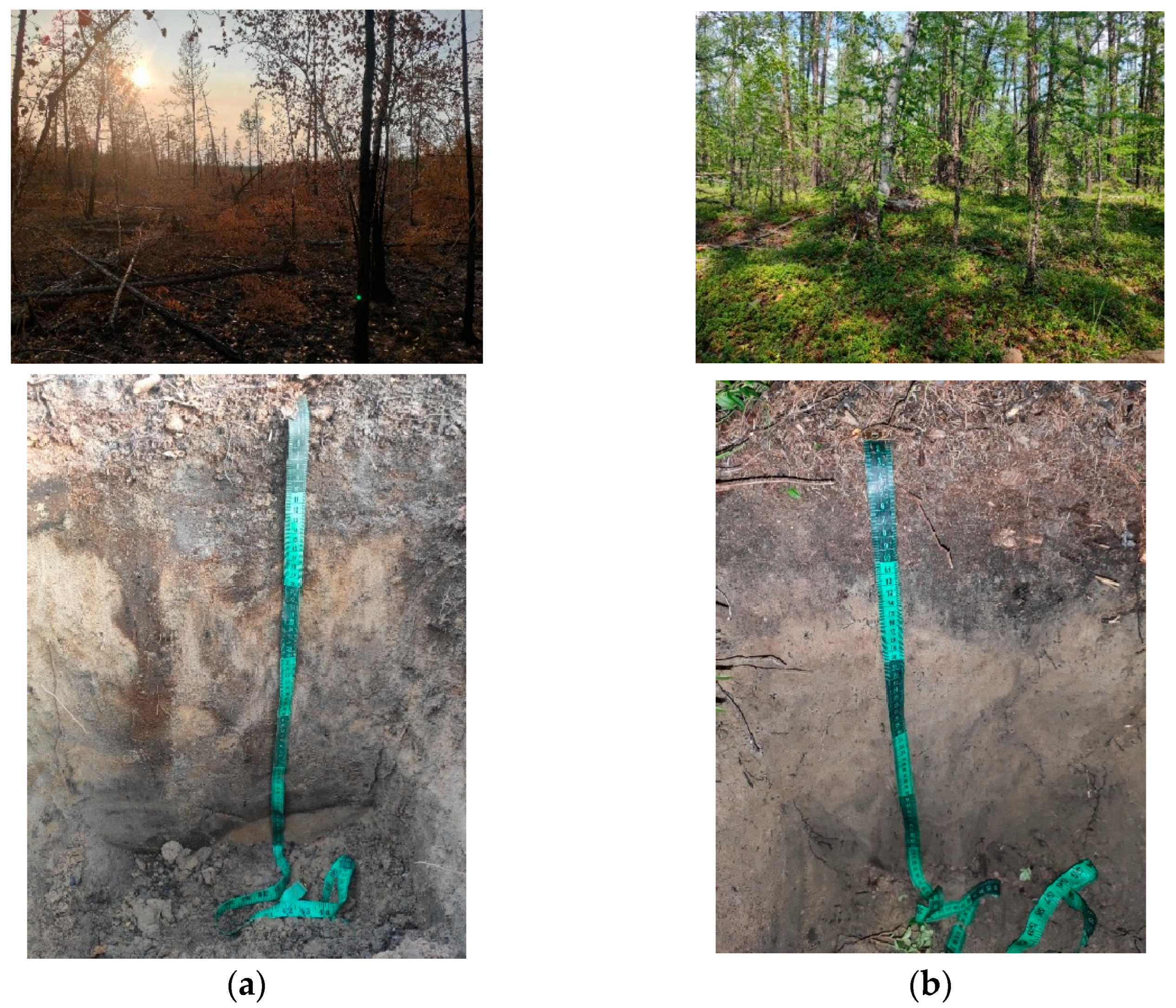
Studies of burned soils in the taiga zone were conducted in 2021, using the example of the Gornyi forestry territory in the Yakutia region. The top layer of the litter was affected by the fires of 2021: one soil pit was placed in the burned area and one pit was placed in the nonburnt area as a control. The vegetation cover consisted of Larix dahurica and Betula platyphylla Ledum L. with depressed-tuberculate relief. A similar area of the forest ecosystem, with the same type of soil but not subjected to forest fire, was used as a control. The soil in the pyrogenic area was a pale-yellow burned soil (Calcic Cryosol (stagnic)—WRB) with the profile structure Ah-A/B-Bs. The lower part of the soil profile had the structure typical of pale-yellow soil. Calcic Cryosol (arenic) with the soil profile Oi-O/A-Bs-B/Ck was described in the control plot. Soil identification was carried out using the “Classification and Diagnostics of Soils of Russia” (2004) [40] and the World Reference Base for Soil Resources (FAO 2015) (WRB) [41]. The characteristics of the studied soils and their horizons are given in Table 1; photos are given in Figure 2. Three soil profiles in each study plot were investigated; in this paper, generalized soil profiles for both situations are described.

2.2. Chemical Analyses of the Fine-Earth of Soils

All samples were dried at +25 °C at the Department of Applied Ecology of Saint-Petersburg State University and then sieved through a 2 mm sieve. The pH was determined in H2O suspensions of fine earth using a pH meter: solution ratio 1:2.5 for mineral fine earth and 1:25 for organic substrata. The carbon content (C) was determined via dichromate oxidation–titration method [42].
Basal respiration (Vbasal) was evaluated by measuring CO2 in a 0.1 molar sodium hydroxide solution. Incubation was conducted for 10 days in sealed plastic containers before CO2 measurement [43,44]. The particle size distribution was determined via the sedimentation method [45,46].
The carbon content of the microbial biomass (Cmic) in the samples was determined via the fumigation method [43,47].
The selected soil samples were analyzed for the total contents of Pb, Cd, Cu, Ni, and Zn. The determination of total heavy metal contents in selected samples was carried out via soil–flame and electrothermal atomic absorption spectrometric method in aqua regia extracts, using a Kvant 2M atomic absorption spectrophotometer (Moscow, Russia) according to the standard ISO 11047-1998 [48]. For each soil sample, total soil pollution index (Zc) and soil pollution index (SPI) were calculated.
Standard limiting indicators were used to calculate the soil pollution index. SPI is an integral indicator of maximum allowable concentration (MAC) and is calculated using the following formula:
SPI = m i ( C i C MAC ) / n
where ( C i C MAC ) is the ratio of the substance content at the sampling point to MAC; n is the amount of ingredients to be determined.
A soil was considered contaminated when the SPI value > 1.0. The data from the national report on the state and environmental protection of the Republic of Sakha (Yakutia) in 2019 were taken as background contents of trace elements [49].
A method of vertical electrical resistivity sounding (VERS) that allows the soil layer to be divided vertically into genetic layers with different properties and characteristics [50,51] was applied using a portable LandMapper device (ERM-03). Measurements of the apparent electrical resistance for soils and strata were carried out at electrode spacings MN 10 and AB/2 10, 20, 30, 40, 50, 60, 70, 80, 90, 100, 150, 200, 300, 400, and 500 cm. This made it possible to establish values of the apparent soil electrical resistance at corresponding depths. The results of the field measurements were recalculated according to the method of A.I. Pozdnyakov, in accordance with geometric coefficients for the different depths and spacings of the AB and MN electrodes [52,53]. A ZondIP 1D layer software model was used for data processing and visualization [54,55]. Models obtained using ZondIP software provided data on apparent electrical resistivity value changes with the layer thickness (h) and layer depth (z).
Normal distribution of the data was verified and a variance analysis (ANOVA) and post hoc test (Fisher’s least significant difference) were performed. Differences were considered significant at p < 0.05. Statistical data processing and analysis were carried out using standard methods in the software packages MS Excel 2016, Past (version 3.20), and Statistica 64 (version 10).

3. Results and Discussion

The studied soil profiles were determined to be Calcic Cryosols according to the WRB system and pale-yellow soils according to the Russian soil classification system. It should be noted that burned soils fit poorly into the framework of existing soil classifications. Postfire succession soils are represented by surface organogenic horizons that retain traces of pyrogenic impact: burnt moss tirr. Only the upper part of the organic horizon (Oi) was burned and charred by fire and transformed to a pyrogenic horizon (Ah).
The presence of charcoal particles was visually diagnosed at the boundary of the organic and Bs horizons. The lower part of the soil profile had the structure typical of pale-yellow soils. Therefore, the effect of fire on soil macromorphology was pronounced only in the topsoil or superficial soil horizons.
Moss litter and the topsoil humus horizon are most affected by the impact of fire, and a loss of organic matter and the formation of “pyrogenic humus” resistant to biodegradation and oxidation are thought to take place.
The data on the basic soil properties of the studied pale-yellow soils are given in Table 2.
In the newly formed Ah horizon consisting of partial combustion products and ash, the pH value was 0.5 units higher than that in the Oi horizon before burning. Short-term changes in acidity after a fire due to ash input have been described previously [14,56]. The pH values in the underlying layers gradually increased towards the B/Ck horizon up to 6.2.
The results of the ANOVA showed no significant differences in the pH and Ctotal of soils between postfire and control plots. Fisher’s F-criterion and p-values showed the absence of statistically significant differences in the mean values. The p-values obtained in the statistical analysis considerably exceeded the critical value of 0.05. This indicates the absence of significant statistical differences in the mean values of pH and Ctotal between postfire and control plots.
The data obtained for the total carbon content showed a slight increase in the topsoil after fire. The upper horizons of burned soils had an average C content of 2.49%, while the control soils had less content of C in the topsoil at 1.95%. These data disagree with the information provided in some previous studies about a decrease in organic matter content of as a result of fires [57,58]; nevertheless, most studies confirm that an increase in total organic matter content in the upper mineral horizons may occur during the initial postfire months [14,59], but in a few years it is usually leveled in conditions with a soil percolation regime. This is carbon from pyrogenic compounds (Cpyr). At first, the additional supply of carbonized plant residues, including branches and wood bark, contributes to an increase in the concentration of total carbon in this horizon [60]. Second, mineralization processes are slowed down in these partly charred materials due to their higher resistance against biotic decomposition compared to the original organic materials, and also due to the degradation of soil biota by high temperatures on the surface.
The levels of basal respiration differed significantly (p < 0.05) between burned (34.47 mg CO2/100 g soil/day) and mature (249.46 mg CO2/100 g soil/day) soils. Control soils showed higher levels of carbon dioxide emission compared to postfire soils (especially in the topsoil horizons). A slight increase in CO2 emission in the B/Ck horizon of the control soil (37.60 mg CO2/100 g soil/day) was associated with an increased content of carbonates.
The intensity of carbon dioxide emission in soils is mainly due to two factors: the presence of available nutrients and the number of microorganisms; moreover, both the number and the physiological state of the microbial community are important. The decrease in the rate of soil CO2 emission after fires is obviously associated with the death of microorganisms and plant roots, as the main agents of this gas formation. The content of microbial biomass (Cmic) was significantly reduced as a result of the fires (Table 2). The carbon contents of total microbial biomass in the upper horizons of the control soils were 0.57–0.73 mg·g−1, while they were significantly lower than 0.02 mg·g−1 in the burned soils. These data differ significantly (p < 0.05).
The resulting trace metal contents are presented in Table 3. The total contents of Cu, Zn, Ni, and Pb in the fire-affected soils were higher than in the control ones, as were the soil pollution index and Zc. Analysis of total pollution index Zc (arithmetic sum) data showed that the total pollution for all soil samples was characterized as nonhazardous (Zc < 16). As can be seen in Table 3, the maximum concentration among the metals was observed for Zn (30.3 mg·kg−1 in burned soils; 8.04 mg·kg−1 in mature soils). The minimum concentrations among all metals studied were recorded for Cd in most cases; the maximum value was recorded in a control soil (0.1 mg·kg−1), and the minimum in a burned topsoil (0.06 mg·kg−1).
The total concentrations of Zn and Ni in topsoils were significantly higher than the regional background [49], at 30.3 and 9.92 mg·kg−1, respectively. Pyrogenic processes led not only to slight increases of the soil pollution index and Zc, but to accumulation of Zn and Ni in soils.
The vertical distribution of trace metal concentrations across soil profiles is heterogeneous. In cases of fire, territories are characterized by a regressive–accumulative distribution of heavy metals along the soil profile: metals accumulate in the upper humus horizon of the soil and show a sharp decrease in their concentrations towards the bottom of profile [61]. The control plot was characterized by an eluvial distribution for Zn, Ni, and Pb and an eluvio-illuvial accumulative distribution of heavy metals along the soil profile for Cu and Cd.
No statistically significant differences in the mean values of trace metal concentrations at the p = 0.05 significance level were found. It is worth noting that under the influence of permafrost processes in soil, priority toxicants are not removed from the soil but are buried within the permafrost table [62,63], and, under the influence of cryoturbations, pollutants are able to migrate from the lower horizons to the upper ones and vice versa [64,65].
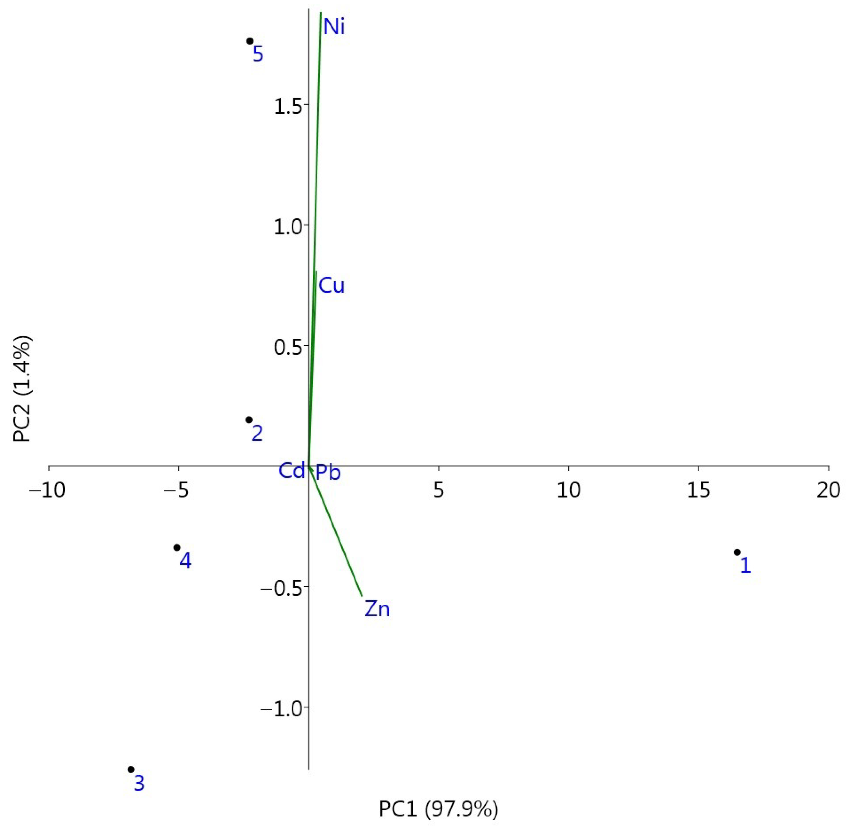
Principal component analysis (PCA) analysis (Figure 3) indicated an accumulation of Zn in the burned soils (Ah horizon).
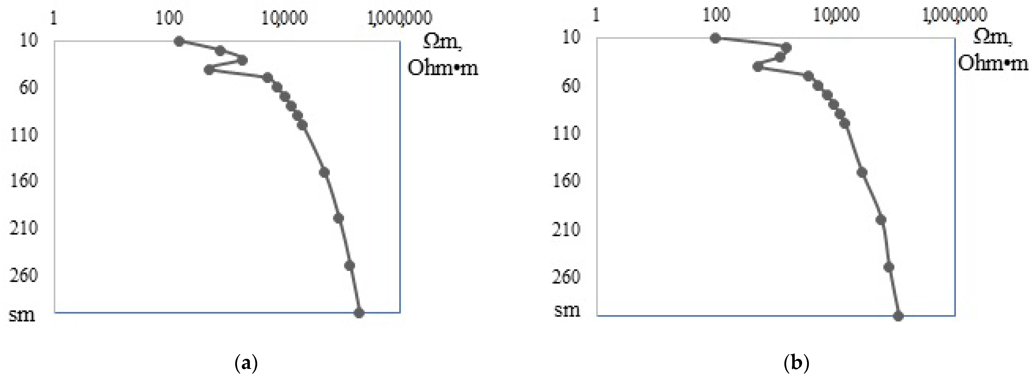
Moreover, measurements of the electrical soil properties were carried out during field studies. These measurements extended to depths of 3 m. The results of field soil-electrophysical studies were further processed using a one-dimensional model (axes: resistance–depth) (Figure 4).
The investigated soils showed low resistance in the upper solum. The main trend was an increase in the value of Ωm with depth, with some disturbances (fluctuations) occurring at the depth of 50 sm (Figure 4), which was identified as the depth of the soil-permafrost layer.
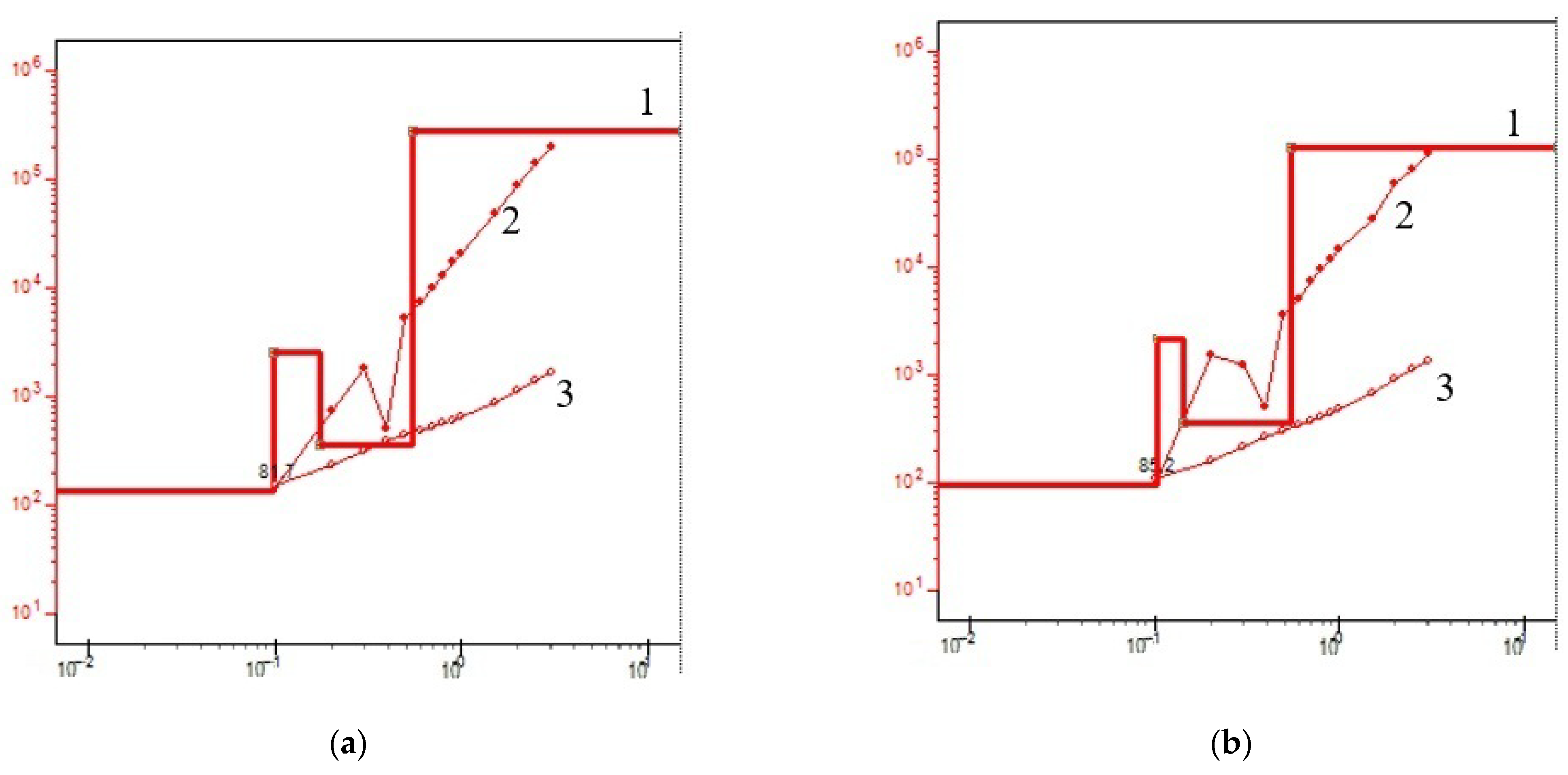
The modeling results for the VERS measurements are shown in Figure 5 and Table 4.
One of the methods used to determine the degree of thermal damage both to tree and plant residues and to soils by fire is the study of electrical resistivity. Changes in the electrical resistance of coal formed during combustion are connected with the increase of carbonization degree. It is believed that electrical resistance consistently declines within a very large range with increasing temperature and duration of thermal impact. However, the effect of pyrolysis time on the value of electrical resistance is less significant than the effect of temperature [66]. Moreover, noninvasive electrical resistivity methods are powerful and quick tools for the study of the hydrophysical properties of soils in areas affected by natural disturbances [67]. Wildfires are known to change soil hydrophysical properties. Nondestructive studies of soil properties based on geophysical measurements are still rarely used in ecological research, although they have been coming to the forefront in recent years.
However, the influence of forest fire on electrical resistance values has not been reliably explored. The B/Ck horizon was clearly distinguished in both studied soils. Thus, the VERS provides precise data about the degree of soil-permafrost layer homogeneity/heterogeneity, and therefore about soil stratification and the presence of geochemical barriers. The VERS method can be effectively used for the identification of layer depth (B/Ck horizon), for specification of soil horizons and borders in field conditions, and for the nondestructive mapping of soil cover. Values of tens of thousands of Ωm are characteristic of permafrost.

4. Conclusions

Russian forest ecosystems and therefore their forest soils have been increasingly faced with wildfires in recent decades. This trend has been particularly consistent in the Yakutia region, where fires are becoming more and more frequent. Pale-yellow soils were investigated in two plots—one not affected by fire and one affected by surface fire in 2021—in the area surrounding Yakutsk, Yakutia region, Eastern Siberia. The data obtained showed an intensive morphological transformation of the topsoil layers, increase of total organic matter and slight increase of pH, and apparent decrease of basal respiration and content of microbial biomass.
The studied soils, both mature and burned soils, were not contaminated with trace metals, which was proven via the application of various individual and complex soil ecotoxicological integrative indices. The potential environmental risk of all soils (including urbanized soils) was evaluated as low, which indicated a good toxicological state of the soils. A slight accumulation of Zn and Ni in soils due to wildfires was recorded, as were alterations in the distributions of heavy metals along the soil profile. Thus, even single fire events can result in serious transformation of the soil geochemical state.
The method of vertical electrical resistivity sounding allows identification of soil heterogeneity, because ER values are strongly affected by soil properties and change significantly at the borders between different geochemical regimes, e.g., on the border between the active layer and the permafrost. Moreover, noninvasive electrical resistivity methods are powerful and quick tools for the study of the hydrophysical properties of soils in areas affected by forest fires. However, there were no differences detected in the two plots, postfire and control.
This study is one of the first attempts to characterize the burned forests and soils of Yakutia: each area of Siberia is important in terms of the inaccuracies in the general estimates of carbon stocks and the determination of forecasts for fire and postfire events in Russia caused by strong data clustering. It is necessary to address the severe data limitations and logistical difficulties encountered in remote regions by continuing the studies we have carried out over a large area and time scale.

Author Contributions

Conceptualization, E.C. and E.A.; methodology, E.C. and V.P.; software, A.P.; validation, E.C. and V.P.; formal analysis, A.P.; investigation, V.P. and A.P.; data curation, E.A.; writing—original draft preparation, E.C.; writing—review and editing, E.A.; visualization, E.C.; supervision, E.A.; funding acquisition, E.C. All authors have read and agreed to the published version of the manuscript.

Funding

The work was supported by the Grant of the President of the Russian Federation for young PhDs No. MK-4596.2022.1.4.

Institutional Review Board Statement

Not applicable.

Informed Consent Statement

Not applicable.

Data Availability Statement

Not applicable.

Acknowledgments

This work is dedicated to the 300th anniversary of Saint Petersburg State University. Soil chemical analyzes were partially conducted in Research park of Saint-Petersburg State University, Chemical Analysis and Materials Research Centre.

Conflicts of Interest

The authors declare no conflict of interest. The funders had no role in the design of the study; in the collection, analyses, or interpretation of data; in the writing of the manuscript; or in the decision to publish the results.

References

  1. Doerr, S.H.; Santın, C. Global trends in wildfire and its impacts: Perceptions versus realities in a changing world. Philos. Trans. R. Soc. B 2016, 371, 20150345. [Google Scholar] [CrossRef] [PubMed] [Green Version]
  2. San-Miguel-Ayanz, J.; Durrant, T.; Boca, R.; Liberta, G.; Branco, A.; de Rigo, D.; Ferrari, D.; Maianti, P.; Arts Vivancos, T.; Schulte, E.; et al. Forest Fires in Europe, Middle East and North Africa 2016; European Commission: Luxembourg, 2017; 126p. [Google Scholar] [CrossRef]
  3. Tarasov, P.A.; Ivanov, V.A.; Ivanova, G.A.; Krasnoshchekova, E.N. Postpyrogenic changes in the hydrothermal parameters of soils in middle-taiga pine forests. Eurasian Soil Sci. 2011, 44, 731–738. [Google Scholar] [CrossRef]
  4. Bento-Goncalves, A.; Vieira, A.; Ubeda, X.; Martin, D. Fire and soils: Key concepts and recent advances. Geoderma 2012, 191, 3–13. [Google Scholar] [CrossRef]
  5. Abakumov, E.; Maksimova, E.; Tsibart, A. Assessment of postfire soils degradation dynamics: Stability and molecular composition of humic acids with use of spectroscopy methods. Land Degrad. Dev. 2017, 29, 2092–2101. [Google Scholar] [CrossRef]
  6. Gonzalez-Perez, J.A.; Gonzalez-Vila, F.J.; Almendros, G.; Knicker, H. The effect of fire on soil organic matter—A review. Environ. Int. 2004, 30, 855–870. [Google Scholar] [CrossRef]
  7. Imeson, A.C.; Verstraten, J.M.; van Mulligen, E.J.; Sevink, J. The effects of fire and water repellence on infiltration and runoff under mediterranean type forest. Catena 1992, 19, 345–361. [Google Scholar] [CrossRef]
  8. Robichaud, P.R. Fire effects on infiltration rates after prescribed fire in northern Rocky Mountain forests, USA. J. Hydrol. 2000, 231, 220–229. [Google Scholar] [CrossRef]
  9. Fultz, L.M.; Moore-Kucera, J.; Dathe, J.; Davinic, M.; Perry, G.; Wester, D.; Schwilk, D.W.; Rideout-Hanzak, S. Forest wildfire and grassland prescribed fire effects on soil biogeochemical processes and microbial communities: Two case studies in the semi-arid Southwest. Appl. Soil Ecol. 2016, 99, 118–128. [Google Scholar] [CrossRef]
  10. Mataix-Solera, J.; Cerda, A.; Arcenequi, V.; Jordan, A.; Zavala, L.M. Fire effects on soil aggregation: A review. Earth-Sci. Rev. 2011, 109, 44–60. [Google Scholar] [CrossRef]
  11. Santin, C.; Doerr, S.H.; Merino, A.; Bryant, R.; Loader, N.J. Forest floor chemical transformations in a boreal forest fire and their correlations with temperature and heating duration. Geoderma 2016, 264, 71–80. [Google Scholar] [CrossRef] [Green Version]
  12. Krasnoshchekov, Y.N.; Cherednikova, Y.S. Postpyrogenic transformation of soils under Pinus sibirica forests in the southern Lake Baikal basin. Eurasian Soil Sci. 2012, 45, 929–938. [Google Scholar] [CrossRef]
  13. Certini, G. Fire as a soil-forming factor. Ambio 2014, 43, 191–195. [Google Scholar] [CrossRef] [PubMed] [Green Version]
  14. Dymov, A.A.; Abakumov, E.V.; Bezkorovaynaya, I.N.; Prokushkin, A.S.; Kuzakov, Y.V.; Milanovsky, E.Y. Impact of forest fire on soil properties (review). Theor. Appl. Ecol. 2018, 4, 13–23. [Google Scholar] [CrossRef]
  15. Dymov, A.A.; Gabov, D.N.; Milanovskii, E.Y. 13C-NMR, PAHs, WSOC and water repellence of fire-affected soils (Albic Podzols) in lichen pine forests, Russia. Environ. Earth Sci. 2017, 76, 275. [Google Scholar] [CrossRef]
  16. Hockaday, W.C.; Grannas, A.M.; Kim, S.; Hatcher, P.G. The transformation and mobility of charcoal in a fire impacted watershed. Geochim. Cosmochim. Acta 2007, 71, 3432–3445. [Google Scholar] [CrossRef]
  17. Reisser, M.; Purves, R.S.; Schmidt, M.W.I.; Abiven, S. Pyrogenic carbon in soils: A literature-based inventory and a global estimation of its content in soil organic carbon and stocks. Front. Earth Sci. 2016, 4, 80. [Google Scholar] [CrossRef] [Green Version]
  18. Singh, N.; Abiven, S.; Torn, M.S.; Schmidt, M.W.I. Fire-derived organic carbon in soil turns over on a centennial scale. Biogeosciences 2012, 9, 2847–2857. [Google Scholar] [CrossRef] [Green Version]
  19. Leifeld, J.; Alewell, C.; Bader, C.; Krüger, J.P.; Mueller, C.W.; Sommer, M.; Steffens, M.; Szidat, S. Pyrogenic carbon contributes substantially to carbon storage in intact and degraded northern peatlands. Land Degrad. Dev. 2018, 29, 2082–2091. [Google Scholar] [CrossRef]
  20. Euronews. Fires in Yakutia Are the Largest in the World. 2021. Available online: https://web.archive.org/web/20210813110645/https://ru.euronews.com/2021/08/11/yakutia-forest-fires-largest-in-the-world. (accessed on 30 September 2022).
  21. Andreev, D.V. Forest fires in Yakutia. StudNet 2021, 10, 1–6. Available online: https://cyberleninka.ru/article/n/analiz-i-mery-likvidatsii-lesnyh-pozharov-po-respublike-saha-yakutiya-za-2021-god (accessed on 7 November 2022).
  22. Solovyev, V.S.; Kozlov, V.I.; Smirnov, I.F. Spatio-temporal dynamics of forest fires in Yakutia. Nat. Resour. Arct. Subarct. 2005, 1, 67–73. [Google Scholar]
  23. Solovyev, V.S.; Kozlov, V.I. The disastrous forest fires in the Yakutia. In Proceedings of the 1st International Conference on Hydrology and Water Resources in Asia Pacific Region (APHW2003), Kyoto, Japan, 13–15 March 2003; pp. 222–224. [Google Scholar]
  24. Shcherbakov, I.P.; Zabelin, O.F.; Karpel, B.A. Forest Fires in Yakutia and Their Influence on the Nature of the Forest; Nauka: Novosibirsk, Russia, 1979; 226p. [Google Scholar]
  25. Vasiliev, M.S.; Vasilieva, S.A.; Solovyev, V.S.; Kozlov, V.I. Distribution of pyrogenic events and cloudiness in Yakutia on remote sensing data (1997–2005). Vestn. Yakutsk. State Univ. 2006, 3, 36–42. [Google Scholar]
  26. Solovyev, V.S. Weekly variations of forest fires in Yakutia. Nat. Resour. Arct. Subarct. 2009, 1, 66–70. [Google Scholar]
  27. Sukhinin, A.I. Aerospace monitoring of catastrophic fires in the forests of Eastern Siberia. Reshetnevskiye Read. 2009, 13, 189–190. [Google Scholar]
  28. Lytkina, L.P. Forest fires role in larch renewal in Central Yakutia. Vestn. Yakutsk. State Univ. 2006, 3, 36–42. [Google Scholar]
  29. Isaev, A.P. Natural and Anthropogenic Dynamics of Larch Forests in the Permafrost Zone (on the Example of Yakutia). Ph.D. Thesis, IBPC SB RAS, Yakutsk, Russia, 2011. [Google Scholar]
  30. Timofeev, P.A.; Isaev, A.P.; Shcherbakov, I.P. Forests of the Middle Taiga Subzone of Yakutia; Desyatkin, R.V., Ed.; YSC SB RAS: Yakutsk, Russia, 1994; 140p. [Google Scholar]
  31. Protopopova, V.V.; Gabysheva, L.P. Pyrological characteristic of vegetation in forests of Central Yakutia and its dynamics in post-fire period. Nat. Resour. Arct. Subarct. 2018, 25, 80–86. [Google Scholar] [CrossRef]
  32. Protopopova, V.V.; Gabysheva, L.P. Forest fire zoning of the forest resources in Republic of Sakha (Yakutia). Successes Mod. Nat. Sci. 2016, 8, 120–125. [Google Scholar]
  33. Desyatkin, R.V.; Desyatkin, A.R.; Fedorov, P.P. Temperature regime of the forest soils, Central Yakutia. Earth’s Cryosphere 2012, 16, 70–78. [Google Scholar]
  34. Gubin, S.V. The Holocene history of soil development in coastal lowlands of northern Yakutia. Eurasian Soil Sci. 2001, 34, 1257–1264. [Google Scholar]
  35. Okonesnikova, M.V. Current state and prediction of changes in soils of the middle Lena valley (Central Yakutia). Tomsk. State Univ. J. Biol. 2013, 3, 7–18. [Google Scholar]
  36. Okonesnikova, M.V. Influence of the main gas pipeline construction on the soil cover in the conditions of central Yakutia. Bull. KrasGAU 2012, 9, 50–53. [Google Scholar]
  37. Okonesnikova, M.V.; Ivanova, A.Z. Soils and technogenic surface formations of an industrial base of Yakutsk city. Vestn. North-East. Fed. Univ. 2020, 6, 5–19. [Google Scholar] [CrossRef]
  38. Savvinov, D.D.; Makarova, M.P.; Timofeev, A.G.; Kowalski, D.V. Trace elements in the soils of the suburban zone of Yakutsk. Nauka Obraz. 2014, 2, 7–10. [Google Scholar]
  39. Decree of the republic of Sakha (Yakutia) dated 19.12.2018 2077-Z No. 45-VI “On the Strategy for the socio-economic development of the Republic of Sakha (Yakutia) until 2032 with a target vision until 2050” (as amended on 18.06.2020). Available online: https://docs.cntd.ru/document/550299670 (accessed on 7 November 2022).
  40. Shishov, L.L.; Tonkonogov, V.D.; Lebedeva, I.I.; Gerasimova, M.I. Classification and Diagnostics of Soils in Russia; Ojkumena: Smolensk, Russia, 2004; p. 342. [Google Scholar]
  41. IUSS Working Group WRB. World Reference Base for Soil Resources International Soil Classification System for Naming Soils and Creating Legends for Soil Maps; World Soil Resources Reports No. 106; FAO: Rome, Italy, 2015. [Google Scholar]
  42. Walkley, A.A. Critical examination of a rapid method for determining organic carbon in soils—Effect of variations in digestion conditions and of inorganic soil constituents. Soil Sci. 1947, 63, 251–264. [Google Scholar] [CrossRef]
  43. Jenkinson, D.; Powlson, D. The effects of biocidal treatments on metabolism in soil—V: A method for measuring soil biomass. Soil Biol. Biochem. 1976, 8, 209–213. [Google Scholar] [CrossRef]
  44. Fedorova, N.N. Methodological Recommendations to the Lecture Course “Biological Analysis of Soils”; Saint Petersburg State University: St. Petersburg, Russia, 2004. (In Russian) [Google Scholar]
  45. Jackson, C.E.; Saeger, C., Jr. Use of the pipette method in the fineness test of molding sand. J. Res. Natl. Bur. Stand. 1935, 14, 59. [Google Scholar] [CrossRef]
  46. Kachinskiy, N.A. Mechanical and Micro-Aggregate Composition of the Soil, Methods of Its Study; MGU Press: Moscow, Russia, 1958. (In Russian) [Google Scholar]
  47. Vance, E.D.; Brookes, P.C.; Jenkinson, D.S. An extraction method for measuring soil microbial biomass C. Soil Biol. Biochem. 1987, 6, 703–707. [Google Scholar] [CrossRef]
  48. ISO 11047; 1998 Soil Quality—Determination of Cadmium, Chromium, Cobalt, Copper, Lead, Manganese, Nickel and Zinc—Flame and Electrothermal Atomic Absorption Spectrometric Methods. ISO: Geneva, Switzerland, 1998.
  49. Government of the Republic of Sakha (Yakutia), Ministry of Ecology of the Republic of Sakha (Yakutia). National Report on the State and Environment Protection of the Republic of Sakha (Yakutia) in 2019; Afanasiev, S.M., Volkova, L.S., Olesova, A.I., Kychkina, I.I., Eds.; Ministry of Ecology of the Republic of Sakha (Yakutia): Yakutsk, Russia, 2020.
  50. Pozdnyakov, A.I.; Pozdnyakova, L.A.; Pozdnyakova, D.A. Constant Electric Fields in Soils; Monograph: San Francisco, CA, USA, 1996; pp. 1–360. [Google Scholar]
  51. Pozdnyakov, A.I. Electrical parameters of soils and pedogenesis. Eurasian Soil Sci. 2008, 10, 1050–1058. [Google Scholar] [CrossRef]
  52. Pozdnyakova, A.D.; Pozdnyakov, L.A.; Antsiferova, O.N. Universal device for measuring the electrical soil properties. Bull. Sci. Pract. 2018, 4, 232–245. Available online: http://www.bulletennauki.com/pozdnyakova-1 (accessed on 15 April 2018).
  53. Marchenko, M.N. Vertical Electrical Sounding. Textbook; Moscow State University, Faculty of Geology: Moscow, Russia, 2013; p. 30. [Google Scholar]
  54. Abakumov, E.; Tomashunas, V. Electric resistivity of soils and upper permafrost layer of the Gydan peninsula. Polarforschung 2016, 86, 27–34. [Google Scholar] [CrossRef]
  55. Alekseev, I.; Kostecki, J.; Abakumov, E. Vertical electrical resistivity sounding (VERS) of tundra and forest tundra soils of Yamal region. Int. Agrophys. 2017, 31, 1–8. [Google Scholar] [CrossRef]
  56. Bodí, M.B.; Martin, D.A.; Balfour, V.N.; Santín, C.; Doerr, S.H.; Pereira, P.; Cerd`a, A.; Mataix-Solera, J. Wildland fire ash: Production, composition and eco-hydrogeomorphic effects. Earth Sci. Rev. 2014, 130, 103–127. [Google Scholar] [CrossRef]
  57. Maslov, M.N.; Maslova, O.A.; Kopeina, E.I. Changes in the pools of total and labile soil organic carbon during the post-fire succession in tundra ecosystems of the Khibiny mountains. Soil Sci. 2020, 3, 330–339. [Google Scholar] [CrossRef]
  58. Zenkova, I.V. Soil and Soil Fauna of the Pyrogenic Forest: Consequences of a Surface Fire in the Khibiny Mountain Group. In Proceedings of the VII Congress of Soil Scientists Society Named by V.V. Dokuchaev and the All-Russian Scientific Conference with Foreign Participation “Soil Science—Food and Environmental Security of the Country”, Belgorod, Russia, 15–22 August 2016; Part I. pp. 221–222. [Google Scholar]
  59. Dymov, A.A.; Dubrovskii, Y.A.; Gabov, D.N. Pyrogenic changes in iron alluvial podzols in the middle taiga of the Komi Republic. Eurasian Soil Sci. 2014, 47, 47–56. [Google Scholar] [CrossRef]
  60. Santin, C.; Doerr, S.H.; Jones, M.W.; Merino, A.; Warneke, C.; Roberts, J.M. The relevance of pyrogenic carbon for carbon budgets from fires: Insights from the FIREX experiment. Global Biogeochem. 2020, 34, e2020GB006647. [Google Scholar] [CrossRef]
  61. Bi, X.; Feng, X.; Yang, Y.; Qiu, G.; Li, G.; Li, F.; Liu, T.; Fu, Z.; Jin, Z. Environmental contamination of heavy metals from zinc smelting areas in Hezhang County, Western Guizhou, China. Environ. Int. 2006, 32, 883–890. [Google Scholar] [CrossRef]
  62. Ji, X.; Abakumov, E.; Antcibor, I.; Tomashunas, V.; Knoblauch, C.; Zubzycki, S.; Pfeiffer, E.-M. Influence of anthropogenic activities on metals in Arctic permafrost: A characterization of benchmark soils on the Yamal and Gydan Peninsulas in Russia. Arch. Environ. Contam. Toxicol. 2019, 76, 540–553. [Google Scholar] [CrossRef]
  63. Ji, X.; Abakumov, E.; Polyakov, V.; Xie, X.; Dongyang, W. The ecological impact of mineral exploitation in the Russian Arctic: A field-scale study of polycyclic aromatic hydrocarbons (PAHs) in permafrost-affected soils and lichens of the Yamal-Nenets autonomous region. Environ. Pollut. 2019, 255, 113239. [Google Scholar] [CrossRef]
  64. Ji, X.; Abakumov, E.; Tomashunas, V.; Polyakov, V.; Kouzov, S. Geochemical pollution of trace metals in permafrost-affected soil in the Russian Arctic marginal environment. Environ. Geochem. Health 2020, 42, 4407–4429. [Google Scholar] [CrossRef]
  65. Abakumov, E.; Shamilishviliy, G.; Yurtaev, A. Soil polychemical contamination on Beliy Island as key background and reference plot for Yamal region. Pol. Polar Res. 2017, 38, 313–332. [Google Scholar] [CrossRef] [Green Version]
  66. Galishev, M.A.; Sharapov, S.V.; Popov, A.V.; Belshina, Y.N.; Dementiev, F.A.; Sikorova, G.A.; Voronova, V.B. Examination of Fires: Textbook; Saint-Petersburg University of State fire Service of Emercom of Russia: St. Petersburg, Russia, 2013; 294p. [Google Scholar]
  67. Homolák, M.; Gömöryová, E.; Pichler, V. Can Soil Electrical Resistivity Measurements Aid the Identification of Forest Areas Prone to Windthrow Disturbance? Forests 2020, 11, 234. [Google Scholar] [CrossRef]
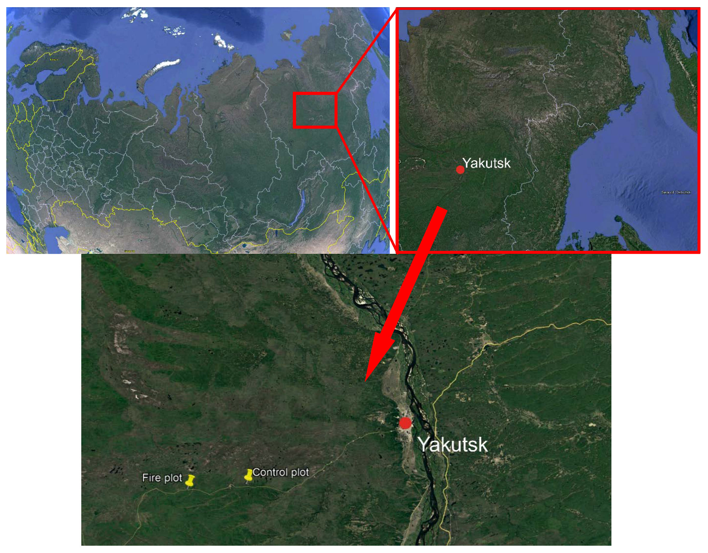
Figure 1. The study site location. The source of this map is Google Earth Pro (https://www.google.com/intl/ru/earth/ (accessed on 7 November 2022)).
Atmosphere 13 01889 g001
Figure 2. Photo of plots and studied soils: (a) burned plot; (b) control plot.
Atmosphere 13 01889 g002
Figure 3. Principal component analysis (PCA) of studied trace metals: 1: Burned soil, Ah, 0–15; 2: Burned soil, Bs, 15–30; 3: Control soil, O/A, 0–13, 4: Control soil, Bs, 13–40; 5: Control soil, B/Ck, 40–55.
Atmosphere 13 01889 g003
Figure 4. Electrical resistivity (ER, Ωm) of burned and control soil profiles: (a) postfire plot; (b) control plot.
Atmosphere 13 01889 g004
Figure 5. Electrical resistivity curves and models of soil profiles at investigated sites. Heavy red line 1: denotes the layer model; thin line 2: denotes measured values; thin line 3: denotes calculated model curves. Vertical scale: ER values (Ωm); horizontal scale: AB/2 distance (m). (a) Postfire plot; (b) control plot.
Atmosphere 13 01889 g005
Table 1. Characteristics of studied soils.
PlotDepth, cmSoil Horizon DescriptionsParticle Size Distribution
Burned plot
Ah0–15Horizon with accumulation of organic matter, pyrogenic, dark-gray, moist, humus streaks (up to 50 cm), coal inclusions.Light loam,
silty–sandy
A/B35–50Streak of organic matter after fire, dark-gray, moist.Light loam,
silty–sandy
Bs15–70Horizon with stagnic conditions and illuvial concentration, light-gray, humus streaks, rust spots.Light loam,
clay–sandy
Control plot
Oi0–5Forest litter, slightly decomposed organic matter
O/A5–13Transitional horizon, organomineral horizon, dark-gray, inclusions of raw organic material, presence of roots, not compacted, not straight border, color transition.Light loam,
silty–sandy
Bs13–40Illuvial accumulation of sesquioxides, iron spots, light-gray, rusty spots, finely cloggy, gradual transition, not clear boundary.Light loam,
clay–sandy
B/Ck40–55Transitional horizon, accumulation of pedogenic carbonates from parent materials, light-gray, darker than the previous one, structureless.Light loam,
silty–sandy
Table 2. General soil properties.
PlotHorizon, Depth, cm p H H 2 O Ctotal, %VbasalCmic
BurnedAh, 0–155.02.49 ± 0.0234.47 ± 0.110.02 ± 0.01
A/B, 35–506.01.42 ± 0.0325.12 ± 0.050.01 ± 0.01
Bs, 15–705.90.40 ± 0.0515.58 ± 0.070.01 ± 0.02
ControlOi, 0–54.5-249.46 ± 0.130.73 ± 0.07
O/A, 5–135.81.95 ± 0.1240.62 ± 0.090.57 ± 0.12
Bs, 13–405.80.23 ± 0.0325.00 ± 0.120.49 ± 0.09
B/Ck, 40–556.20.26 ± 0.0637.60 ± 0.070.06 ± 0.07
Post hoc test
Burned–Control
0.910.45p ≪ 0.05p ≪ 0.05
Significance of differences InsignificantInsignSignSign
Table 3. Contents of trace metals in studied soils, mg/kg.
PlotHorizon, Depth, cmCuZnNiPbCdZcSoil Pollution Index
BurnedAh, 0–155.6230.309.923.100.064.990.3
Bs, 15–704.3212.005.851.960.072.240.2
ControlO/A, 0–132.508.043.861.390.101.150.1
Bs, 13–401.679.575.691.500.062.050.1
B/Ck, 40–553.8511.707.731.670.073.080.2
Regional background values [49]12.620.52.26.20.9
Table 4. Electrical resistivity (Ωm).
PlotP-Modeled Resistivity (Ω m)Z-Bottom Layer Depth (m)Layer Thickness (h), m
Burned135.5400.098
2520.000.0980.075
357.140.170.37
279,769.000.55
Control96.9400.10
2171.400.100.039
357.140.140.41
128,264.980.55
Publisher’s Note: MDPI stays neutral with regard to jurisdictional claims in published maps and institutional affiliations.