Abstract
Based on the multi-source observation data and the National Centers for Environmental Prediction/National Center for Atmospheric Research (NCEP/NCAR) reanalysis data in Hunan from 2002 to 2021, this study statistically analyzes the climatic characteristics of compound severe convection. The distribution characteristics and prediction thresholds of environmental parameters of compound severe convective weather, thermal hail, thunderstorm gale and short-term heavy precipitation events in Hunan, are compared and analyzed. The results show that: (1) The primary type of compound severe convection is a thunderstorm gale that accompanies short-term heavy precipitation. The compound severe convection mainly occurs in spring and summer, with the most common occurrence in July. There are seasonal differences in the types of compound severe convection. The primary type in spring is a thunderstorm gale with hail and hail with short-term heavy precipitation. The primary type in summer is a thunderstorm gale with short-term heavy precipitation. The probability of compound severe convection is the highest in southeastern Hunan, and the lowest in southwestern Hunan. (2) The values of the critical physical parameters required for the occurrence of thermal hail, such as the thermal instability stratification, CAPE and 0–6 km vertical wind shear, are the highest, followed by compound severe convection. Compound severe convection also requires high water vapor, which is only inferior to short-term heavy precipitation. (3) The critical physical parameters also differ in spring and summer. For the temperature difference between 850 and 500 hPa, the seasonal difference is not apparent, indicating that all types of severe convective weather need strong convective instability. CAPE is generally higher in summer than in spring, while the surface-specific humidity and 0–6 km vertical wind shear are higher in summer than in spring.
1. Introduction
Severe convective weather has the characteristics of a small space-time scale and strong abruptness. It has strong destructive power, which often causes serious injuries such as crop disasters, house collapses and even casualties. The occurrence of severe convection is closely related to low-level water vapor conditions, atmospheric instability, vertical wind shear and uplift-triggering conditions [,,,,,]. The potential prediction of different types of severe convective weather is an important issue and an intractable problem. Because different types of severe convection have different sensitivity to various environmental conditions, it can be classified by summarizing and comparing the physical parameter characteristics of different types of severe convective weather []. Some scholars have studied the physical parameters representing the characteristics of atmospheric temperature, humidity and dynamics [,], which have certain guiding significance for the potential prediction of severe convective weather. A potentially severe day occurs when the product of convective available potential energy (CAPE) and 0–6 km vertical wind shear (deep-layer shear (DLS)) exceeds 10,000 m3 s−3 in Europe []. Moreover, forecasts of convective hazards are more difficult in situations of modest CAPE (<1000 J kg−1) than large CAPE (>1000 J kg−1) []. Lei et al. [] calculated 18 physical parameters and their six-hour variables using sounding data and found that hail, thunderstorm and rainstorm can be well distinguished. Qiu and He [] compared the physical parameter thresholds of extreme precipitation and hail in Jiangsu, Zhejiang and Shanghai, and found that thresholds have obvious regional differences. Wang et al. [] summarized the physical parameters of classified severe convection in different months using ERA-interim reanalysis data. Zhou et al. [] proposed a series of potential prediction equations for different types of severe convective weather based on different key convection parameters. Zeng et al. [] constructed the prediction probability of classified severe convective weather based on the convective parameters predicted by the mesoscale numerical model. They used the dominant probability as the classification criterion to predict different types of severe convective weather.
Previous research on the physical parameter potential of strong convection prediction is aimed at a single type of severe convection []. In recent years, some scholars have carried out research on compound severe convective weather with multiple severe convection types, but they mainly focus on case analysis [,,], and there is less research on potential prediction. Gao et al. [] studied the environmental parameter threshold of severe and extreme convection cases in central Shandong. It was found that for central Shandong, the unstable energy and water vapor of compound severe weather were obviously higher than that of a single type. Fan and Yu [] classified and compared the sounding data and environmental parameters of compound and single type severe weather in China. The results show that the morphological characteristics of the temperature humidity curve of compound severe weather are similar to those of thunderstorms and hail. There is an apparent dry layer in the middle troposphere, a considerable convective available potential energy (CAPE) and 0–6 km vertical wind shear. The relatively high height of the equilibrium layer and the slight temperature difference between 850 and 500 hPa are closer to the parameters of short-term heavy precipitation. However, due to the lack of samples, only the average value of environmental parameters is counted, and there is no distribution range of statistical parameters. Moreover, the parameters in different parts of China would have different eigenvalues. The unified treatment has erased the regional differences, resulting in considerable limitations. Because of the prominent regional characteristics of severe convective weather and the significant difference in the threshold of environmental parameters, it is necessary to study severe convective weather with a small temporal and spatial scale.
The terrain of Hunan is characterized by an asymmetric horseshoe basin surrounded by Wuling and the Xuefeng Mountains in the East, the Nanling Mountains in the South, the Luoxiao Mountains in the West and the Dongting Plain in the northeast. Affected by the particular terrain, the strong convective weather in spring in Hunan has the characteristics of high frequency and high intensity, which often causes severe casualties and economic losses. By comparing the environmental parameters of compound severe convective weather, this study discusses the threshold of the physical parameters and the difference between compound and single-type severe convective weather in Hunan, which can be used as the basis of severe convective weather potential prediction in Hunan.
2. Data and Method
Severe convective weather defined in China refers to hail with a diameter ≥ 5 mm, tornado or thunderstorm with wind speed ≥17 m/s, or short-term heavy precipitation with precipitation rate ≥20 mm/h []. Hail and thunderstorm gale data are obtained from surface meteorological observation and disaster reporting. Thunderstorm gale refers to the weather when the maximum wind speed is greater than eight, and accompanied by lightning or thunderstorm. For the definition of compound strong convection in Hunan, refer to the definitions of Fan and Yu [] and Gao et al. []. We divided Hunan into five regions according to the topographic study of Guo et al. []. If two or more types of severe convective weather were observed at one station within 24 h or different types of severe convective weather were observed at two or more stations in one of the five regions in Hunan (Figure 1) within 24 h, it was recorded as a compound severe convective day.
The data used in this paper include: (1) meteorological observation data in Hunan derived from the National Meteorological Information Center of the China Meteorological Administration (CMA), such as hourly precipitation, gale, thunderstorm and lightning data and (2) reanalysis data (with a horizontal resolution of 1.0° × 1.0°) provided by the National Centers for Environmental Prediction/National Center for Atmospheric Research (NCEP/NCAR).
This study selected compound severe convective weather cases and cases of a single type of severe convective weather, such as hail, thunderstorm and short-term heavy precipitation within 24 h (from 08:00 BJT on the day to 08:00 BJT on the following day) from 2002 to 2021. The physical parameters were selected as follows:
- (1)
- Parameter characterizing atmospheric energy: CAPE;
- (2)
- Parameter characterizing atmospheric thermal stability: temperature difference between 850 and 500 hPa;
- (3)
- Parameters characterizing atmospheric humidity conditions: surface-specific humidity;
- (4)
- The parameter of dynamic stability: 0–6 km vertical wind shear.
By calculating the physical parameters six hours before the occurrence of severe convective weather, this study statistically analyzed the physical parameters characteristics of severe convective weather in the past 20 years, and refined the threshold of the physical parameters of the single type of severe convective weather and compound type of severe weather.
3. Climatic Characteristics of Compound Severe Convective Weather
Figure 1 shows the spatial distribution of the compound severe convection between 2002 and 2021. The probability of compound severe convection was the highest in southeastern Hunan, followed by central Hunan, Dongting Lake and northwestern Hunan, and southwestern Hunan is the lowest. The main types of compound severe convection in southwestern Hunan were hail accompanied by short-term heavy precipitation and thunderstorm gale accompanied by hail, accounting for 66.7% in total. The main types of compound severe convection in other regions were thunderstorm gale accompanied by short-term heavy precipitation. The principal reason for the most compound severe convective weather in southeastern Hunan is that the temperature in southeastern Hunan was high in summer, and unstable stratification is formed easily near the surface. Therefore, whenever cold air flows southward, cold and warm air flows converge in southeastern Hunan, which is conducive to thunderstorm gales. Moreover, due to the topographic uplift of the Nanling Mountains, short-term heavy precipitation occurs frequently.

Figure 1.
Spatial distribution of the compound severe convective weather from 2002 to 2021 (the number of days of compound severe convection in each region is shown in parentheses).
Figure 2 shows different types of compound severe convective weather from 2002 to 2021. The primary type of compound severe convection was thunderstorm gale accompanied by short-term heavy precipitation, accounting for 60% of the total, followed by hail accompanied by short-term heavy precipitation and thunderstorms accompanied by hail, accounting for 16.4% and 16% of the total, respectively. The number of simultaneous occurrences of the three types was the least, accounting for 7.6% of the total.
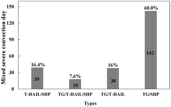
Figure 2.
Different types of compound severe convective weather from 2002 to 2021. T-HAIL represents thermal hail, SHP represents short-term heavy precipitation, and TG represents thunderstorm gale.
Figure 3a shows the interannual variation of the compound severe convection. The frequency of the compound severe convective weather in Hunan shows an upward trend. The frequency of compound severe convection in Hunan shows an upward trend, especially after 2017. In 2018, 2019 and 2021, The compound severe convective weather occurrence exceeded 20 days, and 2021 was the most frequent, with 36 days. Yao et al. [] pointed out that short-term heavy precipitation clearly increased year by year. A total of 84% of the compound severe convective weather was related to short-term heavy precipitation, so the compound severe convective weather also showed the same trend.
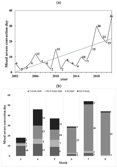
Figure 3.
(a) Interannual variation and (b) monthly variation of the different type of severe convective weather from 2002 to 2021.
Figure 3b shows the monthly variation of compound severe convection. The compound severe convection mainly occurred in spring and summer, most of which occurred in July, followed by August and April. In addition, there were seasonal differences in the types of compound severe convection. The primary type of compound severe convection in spring was thunderstorm accompanied by hail (32 days), followed by thunderstorm accompanied by short-term heavy precipitation (31 days), and finally, the three types appeared simultaneously (24 days). In summer, the main type of compound severe convection was thunderstorm accompanied by short-term heavy precipitation (113 days), and there were few other types.
4. Environmental Parameters of Convection
General convective weather is usually determined by water vapor, instability and uplift conditions [,]. For severe convective weather, deep vertical wind shear and tropospheric dry air intensity should be considered. Dynamic uplift conditions mainly refer to the triggering mechanisms such as the boundary layer convergence line, cold front, trunk line and topographic trigger, which are difficult to represent using convective parameters. Therefore, this paper selects representative physical parameters commonly used in weather forecasting to analyze the characteristics of different environmental parameters according to the conditions of water vapor, instability and deep vertical wind shear [].
Hunan is a horseshoe-shaped terrain surrounded by mountains on three sides and opening to the northeast. When the cold air comes, the mountains block it and form a cold pad. The warm moisture flow climbs on the cold pad and triggers elevated thunderstorms above the boundary layer. Therefore, elevated hail in Hunan mainly occurs in winter (December to February of the following year) when the energy is low and the vertical wind shear is significant. Because there are apparent differences between elevated hail and typical thermal hail, in order to compare the differences in physical parameters between different types of severe convection, we mainly studied thermal hail in spring and summer.
4.1. Static Instability
Thunderstorms mainly occur under unstable conditions, and static instability is usually represented by a temperature difference between 850 and 500 hPa. The greater the difference, the stronger the instability [,,]. From the median values of the temperature difference between 850 and 500 hPa for different types of severe convective weather (Figure 4), thermal hail was the highest, followed by compound severe convection and thunderstorm gale, and short-term heavy precipitation was the lowest. This shows that stratification is most unstable when thermal hail occurs. The range from the 25th percentile to the 75th percentile of the temperature difference between 850 and 500 hPa of different types of severe convection was relatively concentrated: within 3 °C.
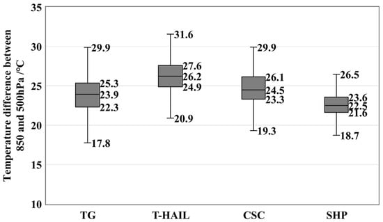
Figure 4.
Box and whisker plots of the temperature difference between 850 and 500 hPa of thunderstorm gale (TG), thermal hail (T-HAIL), compound severe convection (MSC) and short-term heavy precipitation (SHP) in Hunan. (The upper and lower ends of the box-whisker are maximum and minimum values, respectively. The three horizontal lines in the box represent the 25th, 50th and 75th percentile values from bottom to top).
4.2. CAPE
CAPE is the vertical integral of the energy generated by the positive buoyancy when the air parcel rises adiabatically. The increase of CAPE indicates the strengthening of updraft intensity and the development of convection, which can be used to judge thunderstorm potential. From the median values of CAPE (Figure 5), the thunderstorm gale and thermal hail were the highest, followed by compound severe convection and short-term heavy precipitation. CAPE of the compound severe convection and thunderstorm gale was relatively similar; the box is high, and the data are scattered, indicating significant differences in CAPE in different cases. CAPE is relatively concentrated when thermal hail and short-term heavy precipitation occur. CAPE of thunderstorm gale and thermal hail was higher than that of other types.
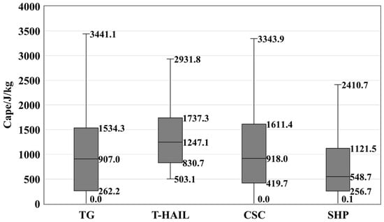
Figure 5.
Same as Figure 4, but for CAPE.
4.3. Water Vapor
Water vapor is one of the primary conditions for the formation of convective weather. Water vapor can be expressed by specific humidity (absolute humidity), relative humidity or temperature and dewpoint difference. This paper uses surface-specific humidity to describe the near-surface absolute water vapor content. The relative humidity difference between 850 and 500 hPa indicates the instability of water vapor stratification in the vertical direction. The surface-specific humidity range of short-term heavy precipitation was narrow, and the value was high, ranging from 11.2 g/kg to 23.8 g/kg (Figure 6). In contrast, the value range of thunderstorm gale, thermal hail and compound severe convection was large. The median surface-specific humidity of short-term heavy precipitation was the highest, followed by compound severe convection, and the median surface-specific humidity of thermal hail was the lowest. Sun et al. [] pointed out that weak vertical wind shear, strong thermal instability, deep humidity in the lower layer and low free convection height, coupled with the involvement of dry air in the middle and upper layers, are very conducive to the development of impulse storms. A downburst is often caused by a pulse storm, coupled with high humidity in the lower layer, and a downburst is accompanied by precipitation, which corresponds to a wet downburst. As most of the thunderstorm gales in Hunan are wet downbursts, the surface-specific humidity of thunderstorm gales was significantly higher than that of compound severe convection and thermal hail. The range from the 25th to 75th percentile of the surface-specific humidity corresponding to thunderstorm gale, thermal hail, compound severe convection and short-term heavy precipitation in the figure indicates a significant difference in specific humidity in thunderstorm gale.
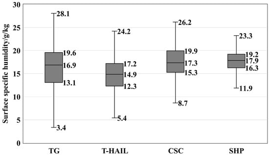
Figure 6.
Same as Figure 4, but for surface humidity.
4.4. Deep Vertical Wind Shear
In the deep moist convection with a given humidity, instability and uplift, the enhancement of vertical wind shear will lead to the further strengthening and development of the storm, and the type of storm can be determined to a great extent []. The 0–6 km vertical wind shear is usually used to represent the deep vertical wind shear, representing the organization degree and intensity of the thunderstorm gale. Yu et al. [] defined the value of vertical wind shear of 0–6 km less than 12 m/s as weak deep vertical wind shear, that which is more than 12 m/s and less than 20 m/s as moderate deep vertical wind shear, and that which is greater than or equal to 20 m/s as strong deep vertical wind shear. As shown in Figure 7, the median values of vertical wind shear of 0–6 km in four kinds of severe convective weather are 10.2 m/s, 18.6 m/s, 12.5 m/s and 10.0 m/s, respectively. Short-term heavy precipitation and thunderstorm gales are weak deep vertical wind shear, thermal hail is strong deep vertical wind shear, and compound severe convection is medium deep vertical wind shear. Most thunderstorm gales under the condition of weak vertical wind shear are caused by pulse storms []. The compound effect of evaporative cooling the dry air in the middle and upper layer and the drag of water vapor in the lower layer strengthens the downdraft, leading to thunderstorm gales. Therefore, the vertical wind shear of a thunderstorm gale was lower than that of thermal hail and compound severe convection, and slightly higher than that of short-term heavy precipitation.
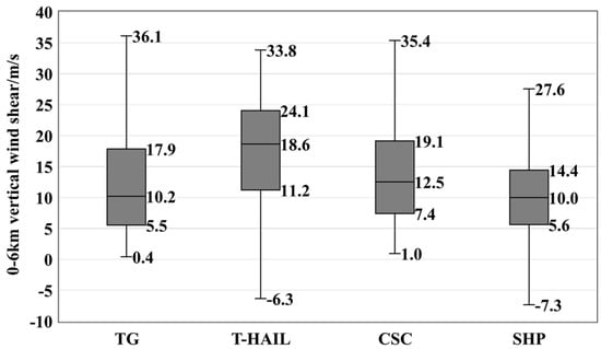
Figure 7.
Same as Figure 4, but for 0–6 km vertical wind shear.
As a severe weather type that can cause disasters, the occurrence of compound severe convection requires strong instability and sufficient water vapor. The 25th percentile of temperature difference between 850 and 500 hPa, CAPE and 0–6 km vertical wind shear of compound severe convective weather were higher than that of thunderstorm gales and short-term heavy precipitation, and the surface-specific humidity required for compound severe convective weather was also higher than that of thunderstorm gales and thermal hail. This conclusion is consistent with that of other scholars. The difference is that Fan and Yu [] and Gao [] believed that the temperature difference between 850 and 500 hPa and 0–6 km vertical wind shear were not the key physical parameters of such weather.
5. Seasonal Differences of Forecast Thresholds
Since severe convective weather mainly occurs in spring and summer, and the prediction thresholds of severe convective weather in different seasons are obviously different, we discuss the differences in physical parameters in spring (from March to May) and summer (from June to August). The 25th percentile value corresponding to various key environmental parameters is taken as the minimum forecast threshold [].
Figure 8 shows the temperature difference between 850 and 500 hPa, CAPE, surface-specific humidity and 0–6 km vertical wind shear of different types of severe convection in spring and summer, respectively. The median values of four types of severe convection were higher than that of wet neutral stratification (20–21 °C), all of which were under conditional unstable stratification (Figure 8a). The seasonal difference of thunderstorm wind was not obvious. The compound severe convection and short-term heavy precipitation were slightly higher in spring than summer, while thermal hail was higher in summer than in spring. It is noted that the minimum value of thermal hail in summer was as high as 24.3 °C, and the maximum value was the highest, indicating that the thermal instability stratification required by thermal hail in summer is the highest.
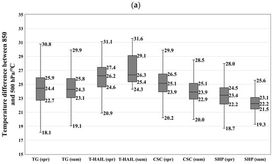
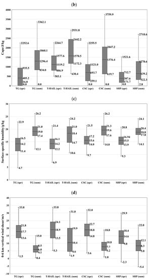
Figure 8.
Box and whisker plots of (a) the temperature difference between 850 and 500 hPa, (b) CAPE, (c) surface-specific humidity and (d) 0–6 km vertical wind shear of thunderstorm gales, thermal hail, compound severe convection and short-term heavy precipitation in Hunan in spring and summer, respectively.
The seasonal differences of CAPE of four severe convection types are obvious (Figure 8b). CAPE was larger in summer than in spring, when severe convection occurs. The CAPE of thermal hail was the highest in summer, and that of short-term heavy precipitation in spring was the lowest. The median of thermal hail, compound severe convection, thunderstorm gales and short-term heavy precipitation decreased in turn in spring and summer.
The difference in the surface-specific humidity in spring and summer is noticeable (Figure 8c). The water vapor in summer was more abundant, exceeding 18 g/kg, and the medium value was about 5 g/kg higher than that in spring. The difference between the 25th percentile and the 75th percentile of thermal hail in summer was the greatest, reaching 6.3 g/kg, followed by the thunderstorm gale in spring, reaching 5.1 g/kg. Other types of severe convection were in the range of 2–4 g/kg.
The deep vertical wind shear of four types of severe convective weather in spring was 8–10 m/s higher than in summer (Figure 8d). The median value of thermal hail and compound severe convection in spring was the highest, followed by thunderstorm gale, and short-term heavy precipitation was the smallest. In summer, the median of thermal hail was the highest, and thunderstorm gales was the lowest, which is related to the fact that thunderstorm gales are mostly caused by pulse storms. The range from the 25th percentile to the 75th percentile of thunderstorm gale and compound severe convection in summer was relatively concentrated, with the difference within 5 m/s, while that of other types was between 7 °C and 15 °C.
Table 1 lists the prediction thresholds (the 25th percentile) of each severe convective weather in spring and summer. It can be seen that the temperature difference between 850 hPa and 500 hPa of thunderstorm gales, thermal hail, compound severe convection and short-term heavy precipitation is not evident in spring and summer. The 25th percentile is used as the prediction threshold, which is 22.7 °C, 24.6 °C, 22.9 °C and 21.5 °C, respectively. The occurrence of all kinds of severe convective weather requires high instability. Specifically, the thermal hail forecast threshold is the highest and the short-term heavy precipitation is the lowest. CAPE in summer was obviously higher than that in spring. The forecast thresholds in spring were 17.1 J/kg, 806.9 J/kg, 259.1 J/kg and 171.7 J/kg, and those in summer were 834.0 J/kg, 1172.3 J/kg, 619.7 J/kg and 322.3 J/kg, respectively. The forecast threshold of thermal hail was the highest in both spring and summer. The surface-specific humidity required for the occurrence of severe convection is obviously lower in spring than in summer. The forecast thresholds in spring were 11.4, 12.2 g/kg, 14.0 g/kg and 13.9 g/kg, and those in summer were 17.4 g/kg, 14.7 g/kg, 17.6 g/kg and 17.5 g/kg, respectively. In spring, the threshold of short-term heavy precipitation and compound severe convection was the highest, while thunderstorm gales were the lowest. In summer, the threshold of thermal hail was the lowest, while others exceeded 17 g/kg. The 0–6 km vertical wind shear in spring was significantly higher than in summer. The prediction thresholds in spring were 13.6 m/s, 13.5 m/s, 14.8 m/s and 9.8 m/s, and that in summer are 4.1 m/s, 4.6 m/s, 5.2 m/s and 5.0 m/s, respectively. The compound severe convection vertical wind shear in spring was the highest, and the short-term heavy precipitation was the lowest. The differences in summer were not apparent.

Table 1.
Thresholds of critical environmental parameters corresponding to classified severe convective weather in Hunan (with 25th percentile as the forecast threshold).
6. Conclusions
Based on the multi-source observation data and NCEP reanalysis data in Hunan from 2002 to 2021, this paper statistically analyzes the climatic characteristics of compound severe convection in Hunan, and compares and analyzes the distribution characteristics and prediction threshold of critical environmental parameters of compound severe convective weather, thermal hail, thunderstorm gales and short-term heavy precipitation, and analyzes the seasonal differences of key parameters. The conclusions are as follows:
From 2002 to 2021, there were 1058 instances of compound severe convection, 1458 thunderstorm gales, 867 instances of thermal hail and 2588 instances of short-term heavy precipitation in Hunan. The main types of compound severe convection are thunderstorm gales with short-term heavy precipitation (accounting for 60%), followed by thermal hail with short-term heavy precipitation (accounting for 16.4%) and thunderstorm gale with thermal hail (accounting for 14.6%). The number of simultaneous occurrences of three kinds of severe convection is the lowest (accounting for 7.6%).
The interannual variation of occurrence frequency of compound severe convection in Hunan shows an upward trend, especially after 2017, and the compound severe convection increased significantly. Compound severe convection exceeded 20 days in 2018, 2019 and 2021, with the most common occurrence in 2021 (36 days). The compound severe convection mainly occurs in spring and summer, and there are obvious seasonal differences. The main types of compound severe convection in spring are thunderstorm gales with thermal hail, followed by thunderstorm gales with short-term heavy precipitation. There is least possibility of three types of severe convection occurring simultaneously. The main types of compound severe convection in summer are thunderstorm gales with short-term heavy precipitation, while other compound severe convections are relatively few.
Compound strong convection is the most probable in southeastern Hunan and the least probable in southwestern Hunan. Specifically, the main types of compound severe convection in southwestern Hunan are thermal hail with short-term heavy precipitation and thunderstorm gales with thermal hail, and the main types of compound severe convection in other areas are thunderstorm gales with short-term heavy precipitation.
The 25th percentile value corresponding to various key environmental parameters is taken as the minimum threshold of compound severe convection, thunderstorm gales, thermal hail and short-term heavy precipitation in Hunan. The conditions required for the occurrence of thermal hail are the greatest, and the thresholds include the temperature difference between 850 hPa and 500 hPa, CAPE and the vertical shear of 0–6 km wind is the highest among the four types of severe convective weather. The thermal and dynamic conditions required for the occurrence of compound severe convective weather are only inferior to thermal hail, and the water vapor conditions required are only inferior to short-term heavy precipitation.
For the seasonal differences, the temperature difference between 850 hPa and 500 hPa is not evident, which requires high instability. CAPE is higher in summer than in spring. The seasonal difference in surface-specific humidity is noticeable. Because the water vapor is more abundant in summer, it is about 5 g/kg higher than in spring. The difference of 0–6 km vertical wind shear is obvious, which is 8–10 m/s higher in spring than in summer.
The threshold of different types of severe convective weather varies greatly. In spring, the recommended minimum thresholds of temperature difference between 850 hPa and 500 hPa for thunderstorm gales, thermal hail, compound severe convection and short-term heavy precipitation are 22.7 °C, 24.6 °C, 23.9 °C and 22.2 °C, respectively; thresholds of CAPE are 17.1 J/kg, 806.9 J/kg, 259.1 J/kg and 171.7 J/kg, respectively; thresholds of surface-specific humidity are 11.4 g/kg, 12.2 g/kg, 14.0 g/kg and 13.9 g/kg, respectively; and thresholds of 0–6 km vertical wind shear are 13.6 m/s, 13.5 m/s, 14.8 m/s and 9.8 m/s, respectively.
In summer, the recommended minimum thresholds of temperature difference between 850 hPa and 500 hPa for four types are 23.1 °C, 25.4 °C, 22.9 °C and 21.5 °C, respectively, thresholds of CAPE are 834.0 J/kg, 1172.3 J/kg, 619.7 J/kg and 322.3 J/kg, respectively, thresholds of surface-specific humidity are 17.4 g/kg, 14.7 g/kg, 17.6 g/kg and 17.5 g/kg, respectively, and thresholds of 0–6 km vertical wind shear are 4.1 m/s, 4.6 m/s, 5.2 m/s and 5.0 m/s, respectively.
Author Contributions
Conceptualization, J.T. and R.Y.; methodology, J.T. and L.X.; analysis J.T., R.Y. and L.X.; data curation, X.O., X.W. and Q.L.; writing—original draft preparation, J.T. and L.X.; writing—review and editing, L.X. and J.T.; project administration, J.T. All authors have read and agreed to the published version of the manuscript.
Funding
This research was funded by Hunan Research and Development Projects (grant number XQKJ21A006), the Key Technology Development Program of China Meteorological Administration (grant number CMAGJ2015M40) and Hunan Research and Development Program of Key Fields (grant number 2019SK2161).
Institutional Review Board Statement
Not applicable.
Informed Consent Statement
Not applicable.
Data Availability Statement
The data presented in this study are available on request from the corresponding author.
Acknowledgments
The authors would like to thank the three anonymous reviewers for their valuable comments and thoughtful suggestions to improve the quality of the paper.
Conflicts of Interest
The authors declare no conflict of interest.
References
- Doswell, C.A., III; Brooks, E., II; Maddox, R.A. Flash flood forecasting: An ingredients-based methodology. Weather Forecast. 1996, 11, 560–581. [Google Scholar] [CrossRef]
- Yu, X.D. Ingredients based forecasting methodology. Meteorol. Monthly. 2011, 37, 913–918. (In Chinese) [Google Scholar]
- Yu, X.D.; Zhou, X.G.; Wang, X.M. The advances in the nowcasting techniques on thunderstorms and severe convection. Acta Meteorol. Sin. 2012, 70, 311–337. (In Chinese) [Google Scholar]
- Zheng, Y.G.; Tao, Z.Y.; Yu, X.D. Some Essential Issues of Severe Convective Weather Forecasting. Meteorol. Monthly. 2017, 43, 641–652. (In Chinese) [Google Scholar]
- Yu, X.D.; Zheng, Y.G. Advances in Severe Convection Research and Operation in China. J. Meteorol. Res. 2020, 34, 189–217. [Google Scholar] [CrossRef]
- Horgan, K.L.; Schultz, D.M.; Hales, J.E.; Corfidi, S.F.; Johns, R.H. A Five-Year Climatology of Elevated Severe Convective Storms in the United States East of the Rocky Mountains. Weather Forecast. 2007, 22, 1031–1044. [Google Scholar] [CrossRef]
- Sun, J.S.; Dai, J.H.; He, L.F.; Zheng, Y.Y.; Yu, X.D.; Xu, A.H. Basic Principles and Technical Methods of Severe Convective Weather Forecast: Handbook of Severe Convective Weather Forecast in China; China Meteorological Press: Beijing, China, 2014; pp. 64–70. (In Chinese) [Google Scholar]
- Li, Y.D.; Liu, J.W.; Gao, S.T. On the Progress of Application for Dynamic and Energetic Convective Parameters Associated with Severe Convective Weather Forecasting. Acta Meteorol. Sin. 2004, 62, 401–409. (In Chinese) [Google Scholar]
- Zhang, L.; Zhang, Y.L.; Lu, H.C.; Show, S.W. Application of Instability Energy Parameters to a Severe Convective Storm Forecast. J. Nanjing Inst. Meteorol. 2008, 31, 192–199. (In Chinese) [Google Scholar]
- Groenemeijer, P.; Pucik, T.; Holzer, A.M.; Antonescu, B.; Riemann-Campe, K.; Schultz, D.M.; Kühne, T.; Feuerstein, B.; Brooks, H.E.; Doswell, C.A.; et al. Severe Convective Storms in Europe: Ten Years of Research and Education at the European Severe Storms Laboratory. Bull. Am. Meteorol. Soc. 2017, 98, 2641–2651. [Google Scholar] [CrossRef]
- Dean, A.R.; Schneider, R.S. An examination of tornado environments, events, and impacts from 2003–2012. In Proceedings of the 26th Conference on Severe Local Storms 2012, Nashville, TN, USA, 5–8 November 2012; Available online: https://ams.confex.com/ams/26SLS/webprogram/Paper211580.html (accessed on 28 August 2022).
- Lei, L.; Sun, J.S.; Wei, D. Distinguishing the Category of the Summer Convective Weather by Sounding Data in Beijing. Meteorol. Monthly 2011, 37, 136–141. (In Chinese) [Google Scholar]
- Qiu, J.J.; He, L.F. Comparative Analysis on Weather Characteristics and Convective Parameters of Torrential Rain and Hail in Yangtze River Delta. Meteorol. Monthly 2013, 39, 577–584. (In Chinese) [Google Scholar]
- Wang, D.; Niu, S.Z.; Zeng, M.J.; Zhang, Y.P. Analysis on the Characteristics of Environmental and Physical Conditions for the Classified Severe Convections in Henan Province. Meteorol. Monthly 2020, 46, 618–628. (In Chinese) [Google Scholar]
- Zhou, F.Y.; Dai, J.H.; Chen, L. Severe Convective Potential Forecast Based on Key Convective Parameter Classification. Meteorol. Sci. Technol. 2020, 48, 229–241. (In Chinese) [Google Scholar]
- Zeng, M.J.; Wang, G.C.; Wu, H.Y.; Shen, Y.; Li, X. Study of the forecasting method for the classified severe convection weather based on a meso-scale numerical model. Acta Meteorol. Sin. 2015, 73, 868–882. (In Chinese) [Google Scholar]
- Liu, H.W.; Xu, J.Y.; Tang, J.; Yao, R.; Hu, Y. Stage characteristics and causes of a compound severe convective weather process. Earth Environ. Sci. 2021, 865, 012021. [Google Scholar]
- Wang, Q.H.; Yao, R.; Zhou, C.Q.; Wang, Q.; Zhang, K. Comparative analysis of compound severe convective weather processes in spring and summer in Hunan. Hubei Agric. Sci. 2021, 60, 65–74. (In Chinese) [Google Scholar]
- Bai, H.; OuYang, D.L.; Zhou, Y.; Zhang, C.; Deng, X.J. The Role of Low-level Jet in a compound Strong Convective Weather Process in Early Spring. Mid-Low Latit. Mt. Meteorol. 2020, 44, 11–18. (In Chinese) [Google Scholar]
- Yao, R.; Tang, J.; Lan, M.C.; Tang, M.H.; Chen, H.Z. Analysis of the environment condition and evolution characteristic for a mixture strong convective event. Torrential Rain Disasters 2017, 36, 217–226. (In Chinese) [Google Scholar]
- Gao, X.M.; Yu, X.D.; Wang, L.J.; Wang, W.B.; Wang, S.J.; Wang, X.H.; Han, X. Characteristics of environmental parameters for classified severe convective weather in central area of Shandong Province. Acta Meteorol. Sin. 2018, 76, 196–212. (In Chinese) [Google Scholar]
- Fan, L.M.; Yu, X.D. Characteristic Analyses on Environmental Parameters in Short-Term Severe Convective Weather in China. Plateau Meteorol. 2013, 32, 156–165. (In Chinese) [Google Scholar]
- Guo, L.Y.; Zhang, X.P.; Liao, Y.F.; Duan, L.J. Climatic Characteristics of Short-duration Rainstorm Events in Hunan Province. J. Catastrophol. 2013, 28, 76–80. (In Chinese) [Google Scholar]
- Yao, R.; Tang, J.; Wang, X.L.; Ou, X.F.; Wang, Q.H.; He, W.W. Temporal-spatial Distribution of Short-time Heavy Rainfall in Hunan and Statistical Analysis of Related Environmental Parameters. J. Catastrophol. 2020, 35, 116–121. (In Chinese) [Google Scholar]
- Zhang, G.C. Analysis and Forecast of Severe Convective Weather; China Meteorological Press: Beijing, China, 2011; pp. 65–72. (In Chinese) [Google Scholar]
- Weisman M, L.; Klemp J, B. The dependence of numerically simulated convective storms on vertical wind shear and buoyancy. Mon. Weather Rev. 1982, 110, 504–520. [Google Scholar] [CrossRef]
Publisher’s Note: MDPI stays neutral with regard to jurisdictional claims in published maps and institutional affiliations. |
© 2022 by the authors. Licensee MDPI, Basel, Switzerland. This article is an open access article distributed under the terms and conditions of the Creative Commons Attribution (CC BY) license (https://creativecommons.org/licenses/by/4.0/).