
An Overview of Triggering Mechanisms and Characteristics of Local Strong Sandstorms in China and Haboobs


 , , ,
, , ,
Abstract
1. Introduction
2. Observation and Weather Diagnosis
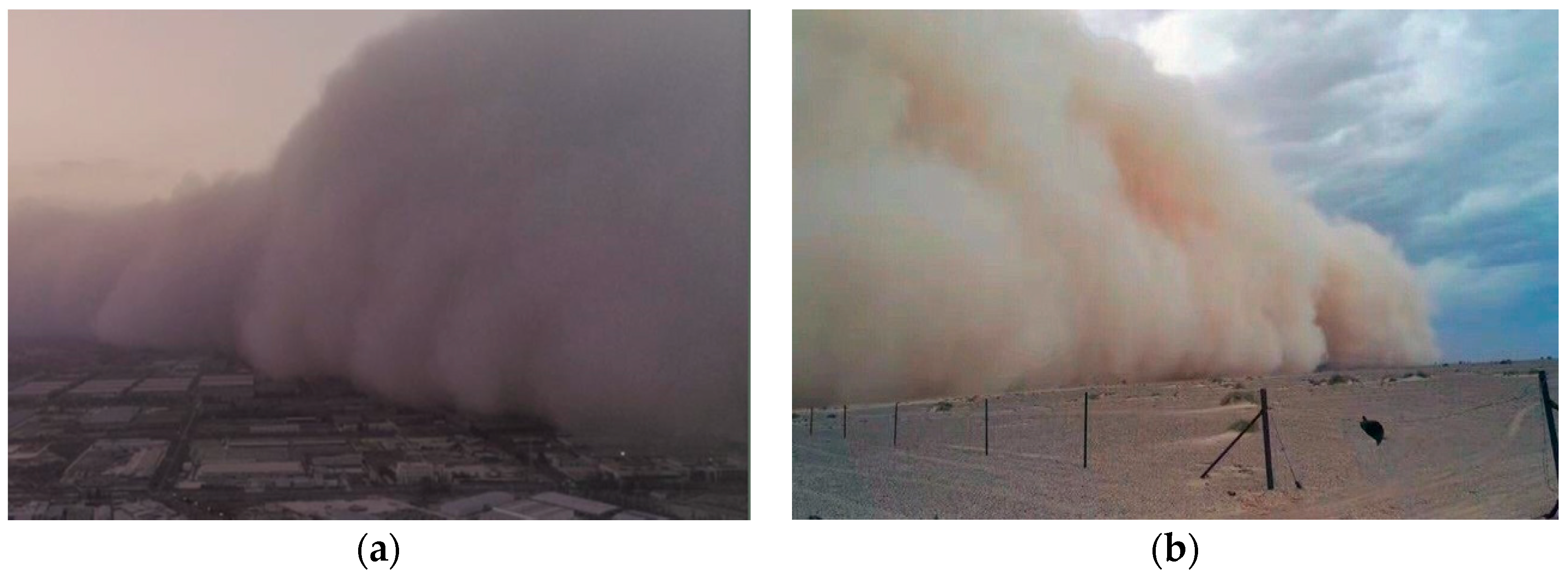
2.1. Haboobs in Northern Africa, Middle East and Southwestern North-America
2.2. Local Strong Thunderstorms in Northwestern China
3. Different Scale Numerical Simulation Methods of LSS/Haboobs
3.1. Mesoscale Simulation Methods of Dust-Uplift by LSS or Haboobs
3.1.1. Mesoscale Simulation Methods of the Wind Field Laden with Haboob Sand
3.1.2. Mesoscale Simulation Methods of Dust-Uplift by LSS
3.2. CFD Simulation Methods of Dust-Uplift by LSS or Haboobs
3.2.1. LES Simulation of Dust-Uplift by Cold Pools
3.2.2. RANS Simulation of Wind Induced LSS by a Cold Pool
4. Triggering of LSS and Haboobs
5. Summary and Perspective
- Observations of meteorological factors in desert and marginal/periphery areas with high-resolution time-series are necessary to obtain the basic information relating to the evolution of LSS or haboobs.
- The development of mesoscale anticyclone or cold pool as the vorticity to trigger LSS or haboobs should be carefully investigated. The intensity and size of a cold pool vorticity usually determines whether convective cells in the mixing layer can develop into LSS or haboobs.
- Small scale, high-resolution CFD numerical simulations should be further developed to investigate the interaction of the upper cold pool with the deep mixing layer for the evolution of haboobs or LSS that cause an up-draught of the air. The simulation of wind-blown gas-solid two-phase flows further supplement our understanding of the uplifting of sand particles by LSS or haboobs and rapid energy dissipation.
- Appropriate numerical simulation analysis method is necessary to determine the dynamic evolution of the downdraught of a cold pool acting with convective cells in the mixing layers. This provides useful information to analyze the transformation of simple thermal convective cells to massive swirling convective cells. The numerical simulation analysis also provides the statistical diagnosis of parameters in the low-pressure zone for the formation of swirling convective structure and the uplifting of sand.
Author Contributions
Funding
Conflicts of Interest
Appendix A

| Characteristics | LSS | Haboobs | |
|---|---|---|---|
| Similarities | Wind speed | >25 m s−1 [24,49] | |
| Visibility | <50 m [27,49] | ||
| Duration | Tens of minutes [24,37] | ||
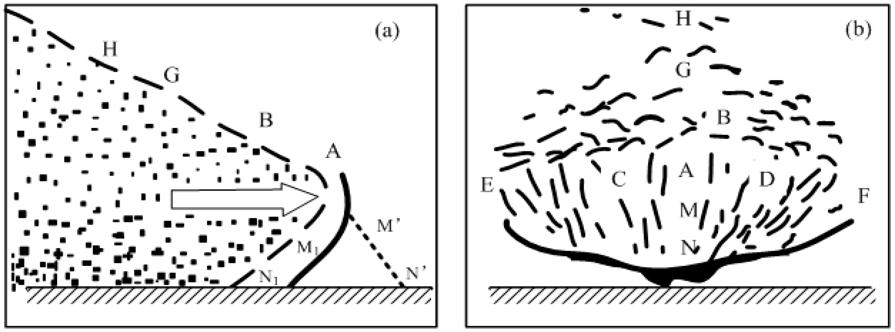
| Shape | Dust wall, lobe-shaped [34,44] | ||
| Differences | Cause | Thermal convection [49] | Moisture convection and thermal convection [17] |
| Region | Northern Africa [23,24,25,26]; Middle East [17,18,27,28,29]; Southwestern North-America [22,30,32,36] | Northwestern China [9,37,38,39,40,41,42,43,44,45,46,47,48,49,50,52,53] | |
| Season | Dry season [49] | Wet season [36] | |
| Weather | No rain [49,50] | Thunderstorms and precipitation [15,51] | |
| Mesoscale simulation | Two-dimensional non-hydrostatic cloud model [50]; integrated operational dust numerical prediction system [77] | Mesoscale multi-day convection-permitting simulations [16,22,62]; NMME–DREAM model [22]; WRF-Chem [28,30,68,72,73] | |
| Small-scale simulation | RANS [19] | LES [82] | |
References
- Chen, F.; Chen, S.; Zhang, X.; Chen, J.; Liu, J. Asian dust-storm activity dominated by Chinese dynasty changes since 2000 BP. Nat. Commun. 2020, 11, 992. [Google Scholar] [CrossRef] [PubMed]
- Zhang, G.; Li, X. Research status of sand-dust storm observation and classification standard. J. Desert Res. 2003, 23, 586–591. (In Chinese) [Google Scholar]
- Pan, Y.Z.; Fan, Y.D.; Shi, P.J.; Gu, X.H. Spatial variation and seasonal distribution of dust-storm in China in resent 50 years: A preliminary study. J. Nat. Disasters 2003, 12, 1–8. (In Chinese) [Google Scholar]
- Yin, X.H.; Wang, S.G. Fractal characteristics and trend forecast of dust—storms and severe-dust—storms in northern China. J. Desert Res. 2007, 27, 130–136. (In Chinese) [Google Scholar]
- Yuan, G. Characteristics and cause of the sandstorm in Inner Mongolia in 2001–2015. J. Desert Res. 2017, 37, 1204–1209. (In Chinese) [Google Scholar]
- Zhao, M.R.; Yan, D.T.; Li, Y.Y.; Zhang, C.S.; Hu, L.L. Change characteristics of sandstorm frequency and its causes in 2001–2010 over Minqin, Gansu, China. J. Desert Res. 2013, 33, 1144–1149. (In Chinese) [Google Scholar]
- Zhao, M.; Liu, M.; Qian, L.; Wang, S.; Li, Y. Variation characteristics of sandstorm from 1871 to 2010 over Minqin oasis and its cause. Desert Oasis Meteorol. 2013, 7, 35–39. (In Chinese) [Google Scholar]
- Basha, G.; Ratnam, M.V.; Kumar, K.N.; Ouarda, T.; Kishore, P.; Velicogna, I. Long-term variation of dust episodes over the United Arab Emirates. J. Atmos. Sol. Terr. Phys. 2019, 187, 33–39. [Google Scholar] [CrossRef]
- Ma, J.; He, Q.; Yang, X.; Huo, W.; Yang, F. Characteristics analysis of regional and local sandstorm over the hinterland of Taklimakan Desert: Taking Tazhong as example. Desert Oasis Meteorol. 2016, 10, 36–42. (In Chinese) [Google Scholar]
- Gu, Z.L. Wind-Blown Sand: Near-Surface Turbulence and Gas-Solid Two-Phase Flow; Science Press: Beijing, China, 2010; Volume 1. (In Chinese) [Google Scholar]
- Neakrase, L.D.V.; Balme, M.R.; Esposito, F.; Kelling, T.; Klose, M.; Kok, J.F.; Marticorena, B.; Merrison, J.; Patel, M.; Wurm, G. Particle lifting processes in dust devils. Space Sci. Rev. 2016, 203, 347–376. [Google Scholar] [CrossRef]
- Reiss, D.; Lorenz, R.D.; Balme, M.; Neakrase, L.D.; Rossi, A.P.; Spiga, A.; Zarnecki, J. Dust devils (Space Sciences Series of ISSI). In Special Issue on Dust Devils; Springer: Berlin/Heidelberg, Germany, 2017. [Google Scholar]
- Freeman, L.H. Duststorms of the Anglo-Egyptian Sudan; Meteorological Reports No.11; Great Britain Met. Office Publication: London, UK, 1952. [Google Scholar]
- Knippertz, P.; Todd, M.C. Mineral dust aerosols over the Sahara: Processes of emission and transport, and implications for modeling. Rev. Geophys. 2009, 50, RG1007. [Google Scholar]
- Idso, S.B.; Ingram, R.S.; Pritchard, J.M. An American haboob. Bull. Am. Meteorol. Soc. 1972, 53, 930–935. [Google Scholar] [CrossRef]
- Solomos, S.; Kallos, G.; Mavromatidis, E.; Kushta, J. Density currents as a desert dust mobilization mechanism. Atmos. Chem. Phys. 2012, 12, 11199–11211. [Google Scholar] [CrossRef]
- Mamouri, R.E.; Ansmann, A.; Nisantzi, A.; Solomos, S.; Kallos, G.; Hadjimitsis, D.G. Extreme dust storm over the eastern mediterranean in september 2015: Satellite, lidar, and surface observations in the cyprus region. Atmos. Chem. Phys. 2016, 16, 13711–13724. [Google Scholar] [CrossRef]
- Miller, S.D.; Kuciauskas, A.P.; Ming, L.; Qiang, J.; Reid, J.S.; Breed, D.W.; Walker, A.L.; Mandoos, A.A. Haboob dust storms of the southern Arabian Peninsula. J. Geophys. Res. Atmos. 2008, 113, 1–16. [Google Scholar] [CrossRef]
- He, Y.; Gu, Z.; Shui, Q.; Liu, B.; Lu, W.; Zhang, R.; Zhang, D.; Yu, C.W. RANS simulation of local strong sandstorms induced by a cold pool with vorticity. Atmosphere 2020, 11, 321. [Google Scholar] [CrossRef]
- Morman, S.A.; Plumlee, G.S. Dust and human health. In Mineral Dust; Knippertz, P., Stuut, J.-B.W., Eds.; Springer: Dordrecht, The Netherlands; Berlin/Heidelberg, Germany; New York, NY, USA; London, UK, 2014; pp. 385–403. [Google Scholar]
- Liu, J.T.; Zheng, M.Q. Climatic characteristics of strong and very strong sandstorms in the middle and west parts of inner mongolia. Plateau Meteorol. 2003, 22, 51–56. [Google Scholar]
- Vukovic, A.; Vujadinovic, M.; Pejanovic, G.; Andric, J.; Kumjian, M.R.; Djurdjevic, V.; Dacic, M.; Prasad, A.K.; El-Askary, H.M.; Paris, B.C. Numerical simulation of “An American Haboob”. Atmos. Chem. Phys. 2014, 14, 26175–26215. [Google Scholar] [CrossRef]
- Prospero, J.M.; Ginoux, P.; Torres, O.; Nicholson, S.E.; Gill, T.E. Environmental characterization of global sources of atmospheric soil dust identified with the NIMBUS 7 total ozone mapping spectrometer (TOMS) absorbing aerosol product. Rev. Geophys. 2002, 40, 1–31. [Google Scholar] [CrossRef]
- Cowie, S.M.; Knippertz, P.; Marsham, J.H. A climatology of dust emission events from northern Africa using long-term surface observations. Atmos. Chem. Phys. 2014, 14, 8579–8597. [Google Scholar] [CrossRef]
- Allen, C.J.T.; Washington, R.; Engelstaedter, S. Dust emission and transport mechanisms in the central Sahara: Fennec ground-based observations from Bordj Badji Mokhtar, June 2011. J. Geophys. Res. Atmos. 2013, 118, 6212–6232. [Google Scholar] [CrossRef]
- Zender, C.S.; Kwon, E.Y. Regional contrasts in dust emission responses to climate. J. Geophys. Res. Atmos. 2005, 110, D13201. [Google Scholar] [CrossRef]
- Solomos, S.; Ansmann, A.; Mamouri, R.E.; Binietoglou, I.; Patlakas, P.; Marinou, E.; Amiridis, V. Remote sensing and modelling analysis of the extreme dust storm hitting the Middle East and eastern Mediterranean in September 2015. Atmos. Chem. Phys. 2017, 17, 1–31. [Google Scholar] [CrossRef]
- Anisimov, A.; Axisa, D.; Kucera, P.A.; Mostamandi, S.; Stenchikov, G. Observations and cloud-resolving modeling of haboob dust storms over the Arabian Peninsula. J. Geophys. Res. Atmos. 2018, 123, 12147–12179. [Google Scholar] [CrossRef]
- Offer, Z.Y.; Goossens, D. Ten years of aeolian dust dynamics in a desert region (Negev desert, Israel): Analysis of airborne dust concentration, dust accumulation and the high-magnitude dust events. J. Arid Environ. 2001, 47, 211–249. [Google Scholar] [CrossRef]
- Raman, A. Modeling and data analysis of 2011 Phoenix dust storm. In Proceedings of the 93rd AMS Annual Meeting, Austin, TX, USA, 5–10 January 2013. [Google Scholar]
- Sutton, L.J. Haboobs. Q. J. R. Meteorol. Soc. 1925, 51, 25–30. [Google Scholar] [CrossRef]
- Bryan, G.H.; Parker, M.D. Observations of a squall line and its near environment using high-frequency rawinsonde launches during VORTEX2. Mon. Weather Rev. 2010, 138, 4076–4097. [Google Scholar] [CrossRef]
- Karam, D.B.; Williams, E.; Janiga, M.A.; Flamant, C.; Mcgrawherdeg, M.; Cuesta, J.; Auby, A.; Thorncroft, C.D. Synoptic-scale dust emissions over the Sahara desert initiated by a moist convective cold pool in early August 2006. Q. J. R. Meteorol. Soc. 2014, 140, 2591–2607. [Google Scholar] [CrossRef]
- Lawson, T.J. Haboob structure at Khartoum. Weather 2012, 26, 105–112. [Google Scholar] [CrossRef]
- Roberts, A.; Knippertz, P. Haboobs: Convectively generated dust storms in West Africa. Weather 2012, 67, 311–316. [Google Scholar] [CrossRef]
- Raman, A.; Arellano, A.F.; Brost, J.J. Revisiting haboobs in the southwestern United States: An observational case study of the 5 July 2011 Phoenix dust storm. Atmos. Environ. 2014, 89, 179–188. [Google Scholar] [CrossRef]
- Li, J. Weather and Climate in Taklimakan Desert and Surrounding Mountain Areas; Science Press: Beijing, China, 2003; pp. 164–173. (In Chinese) [Google Scholar]
- Huo, W.; Xia, L.I.; Mamtimin, A.; Wang, J.; Zhao, X.C. Analysis on the features of sandstorms in the Tarim Basin in Spring 2004. Arid Zone Res. 2006, 23, 210–215. (In Chinese) [Google Scholar]
- Jiang, X.; Shen, J.; Liu, J.; Chen, S. Observational and numerical simulation of some weather factors leading a severe dust storm. Acta Meteorol. Sin. 2003, 61, 606–620. (In Chinese) [Google Scholar]
- Hu, Y.; Mitsuta, Y. Development of the strong dust storm and dry soluall line—A mechanism analysis on generating black storm. Plateau Meteorol. 1996, 15, 178–185. (In Chinese) [Google Scholar]
- Hu, Y.; Mitsuta, Y. Micrometeorological characteristics and local triggering mechanism of strong dust storm. Chin. J. Atmos. Sci. 1997, 21, 581–589. (In Chinese) [Google Scholar]
- Yang, F.; He, Q.; Huang, J.; Ali, M.; Zheng, W. Desert environment and climate observation network over the Taklimakan Desert. Bull. Am. Meteorol. Soc. 2021, 1–53. [Google Scholar] [CrossRef]
- Liu, C.; Cheng, L. Parameterization of the formation and transportion for sand-dust of the black storm and mesoscale numerical experiments. Acta Meteorol. Sin. 1997, 55, 726–739. (In Chinese) [Google Scholar]
- Lu, Q.; Yang, Y.L. Warnings from Global Dust Storm; China Environmental Science Press: Beijing, China, 2001; p. 158. (In Chinese) [Google Scholar]
- Wang, S.G.; Dong, G.R.; Chen, H.Z.; Li, X.L.; Jin, J. Advances in studying sand-dust storms of China. J. Desert Res. 2000, 20, 349–356. (In Chinese) [Google Scholar]
- Wang, S.; Yang, D.; Jing, J.; Xu, Q.; Yang, Y. Study on the formative causes and countermeasures of the catastrophic sandstorm occurred in northwest China. J. Desert Res. 1995, 15, 19–30. (In Chinese) [Google Scholar]
- Song, Z.; Cheng, L. Diagnostic analysis of the perturbation sources on the “93.5” black storm. J. Lanzhou Univ. 1997, 33, 116–122. (In Chinese) [Google Scholar]
- Zhang, X.; Cheng, L. Diagnosis of vorticity source for the genesis and development of mesoscale vortex during “93.5” black storm. J. Lanzhou Univ. 1997, 33, 123–131. (In Chinese) [Google Scholar]
- Takemi, T. Structure and evolution of a severe squall line over the arid region in northwest China. Mon. Weather Rev. 1999, 127, 1301–1309. [Google Scholar] [CrossRef]
- Takemi, T.; Satomura, T. Numerical experiments on the mechanisms for the development and maintenance of long-lived squall lines in dry environments. J. Atmos. Sci. 2000, 57, 1718–1740. [Google Scholar] [CrossRef]
- Farquharson, J.S. Haboobs and instability in the Sudan. Q. J. R. Meteorol. Soc. 2007, 63, 393–414. [Google Scholar] [CrossRef]
- Ma, Y.; Wang, X.; Xiao, K.; Liu, X.; Tan, J. A case study of a black storm at the northern foothills of Tianshan mountains. Acta Sci. Nat. Univ. Pekin. 2006, 20, 193–228. (In Chinese) [Google Scholar]
- Li, L.; Hu, L.; Liu, W.; Li, Y.; Liang, H. Variation characteristic of main meteorological elements during summer sand- dust storm processes in east of Hexi Corridor. J. Arid Meteorol. 2017, 35, 427–432. (In Chinese) [Google Scholar]
- Zhao, Y. Theoretical Analysis and Numerical Simulations for the Formation, Evolution and Structure of Dust Devil. Ph.D. Thesis, Xi’an Jiaotong University, Xi’an, China, 2004. [Google Scholar]
- Scheuvens, D.; Kandler, K. On composition, morphology, and size distribution of airborne mineral dust. In Mineral Dust; Knippertz, P., Stuut, J.-B.W., Eds.; Springer: Dordrecht, The Netherlands; Berlin/Heidelberg, Germany; New York, NY, USA; London, UK, 2014. [Google Scholar]
- Warner, T.T. Desert Meteorology; Cambridge University Press: Cambridge, UK, 2004; p. 612. [Google Scholar] [CrossRef]
- Knippertz, P. Meteorological aspects of dust storms. In Mineral Dust; Knippertz, P., Stuut, J.-B.W., Eds.; Springer: Dordrecht, The Netherlands; Berlin/Heidelberg, Germany; New York, NY, USA; London, UK, 2014. [Google Scholar]
- Knippertz, P.; Trentmann, J.; Seifert, A. High-resolution simulations of convective cold pools over the northwestern Sahara. J. Geophys. Res. Atmos. 2009, 114, D08110. [Google Scholar] [CrossRef]
- Cook, K.H.; Vizy, E.K. Coupled model simulations of the West African monsoon system: Twentieth- and twenty-first-century simulations. J. Clim. 2006, 19, 3681. [Google Scholar] [CrossRef]
- Pantillon, F.; Knippertz, P.; Marsham, J.H.; Panitz, H.-J.; Bischoff-Gauss, I. Modeling haboob dust storms in large-scale weather and climate models. J. Geophys. Res. Atmos. 2016, 121, 2090–2190. [Google Scholar] [CrossRef]
- Roberts, A.J.; Knippertz, P. The formation of a large summertime Saharan dust plume: Convective and synoptic-scale analysis. J. Geophys. Res. Atmos. 2014, 119, 1766–1785. [Google Scholar] [CrossRef]
- Heinold, B.; Knippertz, P.; Marsham, J.H.; Fiedler, S.; Dixon, N.S.; Schepanski, K.; Laurent, B.; Tegen, I. The role of deep convection and nocturnal low-level jets for dust emission in summertime West Africa: Estimates from convection-permitting simulations. J. Geophys. Res. Atmos. 2013, 118, 4385–4400. [Google Scholar] [CrossRef]
- Roberts, A.J.; Woodage, M.J.; Marsham, J.H.; Highwood, E.J.; Ryder, C.L.; Mcginty, W.; Wilson, S.; Crook, J. Can explicit convection improve modelled dust in summertime West Africa? Atmos. Chem. Phys. 2018, 18, 1–36. [Google Scholar] [CrossRef]
- Takemi, T. Explicit simulations of convective-scale transport of mineral dust in severe convective weather. J. Meteorol. Soc. Jpn. Ser. II 2004, 83, 0076. [Google Scholar] [CrossRef]
- Sundram, I.; Claiborn, C.; Strand, T.; Lamb, B.; Chandler, D. Numerical modeling of windblown dust in the Pacific Northwest with improved meteorology and dust emission models. J. Geophys. Res. Atmos. 2004, 109, 1–12. [Google Scholar] [CrossRef]
- Marsham, J.H.; Knippertz, P.; Dixon, N.S.; Parker, D.J.; Lister, G.M.S. The importance of the representation of deep convection for modeled dust-generating winds over West Africa during Summer. Geophys. Res. Lett. 2011, 38, L16803. [Google Scholar] [CrossRef]
- Pope, R.J.; Marsham, J.H.; Knippertz, P.; Brooks, M.E.; Roberts, A.J. Identifying errors in dust models from data assimilation. Geophys. Res. Lett. 2016, 43, 9270–9279. [Google Scholar] [CrossRef] [PubMed]
- Vukovic, A.J.; Pejanovic, G.; Vujadinovic, M.; Sprigg, W.A.; Nickovic, S.; Djurdjevic, V. Dust storm of July 5th 2011, Phoenix, Arizona: Numerical simulation. In Proceedings of the AGU Fall Meeting, San Francisco, CA, USA, 5–9 December 2011. [Google Scholar]
- Foroutan, H.; Pleim, J.E. Improving the simulation of convective dust storms in regional-to-global models. J. Adv. Modeling Earth Syst. 2017, 9, 2046–2060. [Google Scholar] [CrossRef] [PubMed]
- Janjic, Z. The step-mountain eta coordinate model: Further development of the convection vicous sublayer and turbulence closure schemes. Mon. Weather Rev. 1994, 122, 927–945. [Google Scholar] [CrossRef]
- Chamberlain, A.C. Roughness length of sea, sand, and snow. Bound. Layer Meteorol. 1983, 25, 405–409. [Google Scholar] [CrossRef]
- Karegar, E.; Hamzeh, N.H.; Jamali, J.B.; Abadi, A.; Goshtasb, H. Numerical simulation of extreme dust storms in east of Iran by the WRF-CHEM model. Nat. Hazards 2019, 99, 769–796. [Google Scholar] [CrossRef]
- Eltahan, M.; Shokr, M.; Sherif, A.O. Tuning dust schemes in weather research forecast (WRF-CHEM) for simulating severe dust storm events over Egypt. AGU Fall Meet. Abstr. 2017, 2017, A41G-2370. [Google Scholar]
- Xue, M.; Droegemeier, K.K.; Wong, V. The Advanced Regional Prediction System (ARPS)—A multi-scale nonhydrostatic atmospheric simulation and prediction model. Part I: Model dynamics and verification. Meteorol. Atmos. Phys. 2000, 75, 161–193. [Google Scholar] [CrossRef]
- Xue, M.; Droegemeier, K.K.; Wong, V.; Shapiro, A.; Brewster, K.; Carr, F.; Weber, D.; Liu, Y.; Wang, D. The Advanced Regional Prediction System (ARPS)—A multi-scale nonhydrostatic atmospheric simulation and prediction tool. Part II: Model physics and applications. Meteorol. Atmos. Phys. 2001, 76, 143–165. [Google Scholar] [CrossRef]
- Song, Z.X. Numerical prediction system for dust weather. In Proceedings of the Annual Meeting of Chinese Meteorological Society, Beijing, China, 18–21 October 2014. (In Chinese). [Google Scholar]
- Lu, J.J.; Zhao, L.N.; Du, B.Y. The real time numerical prediction and characteristics of a severe dust storm covers China in the Spring of 2004. Clim. Environ. Res. 2007, 12, 188–198. (In Chinese) [Google Scholar]
- Brown, A.R.; Derbyshire, S.H.; Mason, P.J. Large-eddy simulation of stable atmospheric boundary layers with a revised stochastic subgrid model. Q. J. R. Meteorol. Soc. 1994, 120, 1485–1512. [Google Scholar] [CrossRef]
- Gu, Z.; Jiao, J.; Zhang, Y.; Su, J. The nature of a universal subgrid eddy viscosity model in a turbulent channel flow. Europhys. Lett. 2011, 94, 34003. [Google Scholar] [CrossRef]
- Salim, S.M.; Buccolieri, R.; Chan, A.; Sabatino, S.D. Numerical simulation of atmospheric pollutant dispersion in an urban street canyon: Comparison between RANS and LES. J. Wind Eng. Ind. Aerodyn. 2011, 99, 103–113. [Google Scholar] [CrossRef]
- Versteeg, H.K.; Malalasekera, W. An Introduction to Computational Fluid Dynamics: The Finite Volume Method; Pearson Education: London, UK, 2007. [Google Scholar]
- Huang, Q.; Marsham, J.H.; Tian, W.; Parker, D.J.; Garcia-Carreras, L. Large-eddy simulation of dust-uplift by a haboob density current. Atmos. Environ. 2018, 179, 31–39. [Google Scholar] [CrossRef]
- McQuaid, J.; Ryder, C.; Sodemann, H.; Garcia-Carreras, L.; Rosenberg, P.; Banks, J.; Brindley, H.; Todd, M.; Engelstaedter, S.; Flamant, C.; et al. Overview and insights gained by airborne observations over the Sahara during Fennec. In Proceedings of the EGU General Assembly 2013, Vienna, Austria, 7–12 April 2013. [Google Scholar]
- A Strong Sandstorm Has Hit Jinchang City in Gansu Province, Where Temperatures Have Dropped by 10–15 Degrees Celsius. 2012. Available online: https://weather.mipang.com/shaoxing/news-1809468.html (accessed on 2 March 2021).
- Lorenz, R.D.; Balme, M.R.; Gu, Z.L.; Kahanpää, H.; Klose, M.; Kurgansky, M.V.; Patel, M.R.; Reiss, D.; Rossi, A.P.; Spiga, A.; et al. History and applications of dust devil studies. Space Sci. Rev. 2016, 203, 1–33. [Google Scholar] [CrossRef]
- Marsham, J.H.; Hobby, M.; Allen, C.J.T.; Banks, J.R.; Bart, M.; Brooks, B.J.; Cavazos-Guerra, C.; Engelstaedter, S.; Gascoyne, M.; Lima, A.R.; et al. Meteorology and dust in the central sahara: Observations from Fennec supersite-1 during the June 2011 intensive observation period. J. Geophys. Res. Atmos. 2013, 118, 4069–4089. [Google Scholar] [CrossRef]
- Metzger, S.M.; Balme, M.; Farrell, W.M.; Fuerstenau, S.; Zarnecki, J. Resolving Codependent Processes within Natural Dust Devil Vortices; American Geophysical Union: Washington, DC, USA, 2004. [Google Scholar]
- Decroix, D.S.; Lin, Y.L.; Schowalter, D.G. Cellular convection embedded in the convective planetary boundary layer surface layer. J. Wind Eng. Ind. Aerodyn. 1997, 67–68, 387–401. [Google Scholar] [CrossRef]
- Kanak, K.M.; Lilly, D.K.; Snow, J.T. The formation of vertical vortices in the convective boundary layer. Q. J. R. Meteorol. Soc. 2010, 126, 2789–2810. [Google Scholar] [CrossRef]
- Gu, Z.L.; Qiu, J.; Zhao, Y.Z.; Hou, X.P. Analysis on dust devil containing loess dusts of different sizes. Aerosol Air Qual. Res. 2008, 8, 65–77. [Google Scholar] [CrossRef]
- Spiga, A.; Barth, E.; Gu, Z.; Hoffmann, F.; Ito, J.; Jemmett-Smith, B.; Klose, M.; Nishizawa, S.; Raasch, S.; Rafkin, S. Large-eddy simulations of dust devils and convective vortices. Space Sci. Rev. 2016, 203, 245–275. [Google Scholar] [CrossRef]
- Idso, S.B. Dust storms. Sci. Am. 1976, 235, 108–115. [Google Scholar] [CrossRef]
- Gu, Z.; Zhao, Y.; Li, Y.; Yu, Y.; Feng, X. Numerical simulation of dust lifting within dust devils—Simulation of an intense vortex. J. Atmos. Sci. 2006, 63, 2630–2641. [Google Scholar] [CrossRef]
- Gu, Z.L.; Qiu, J.; Zhao, Y.; Li, Y. Simulation of terrestrial dust devil patterns. Adv. Atmos. Sci. 2008, 25, 31–42. [Google Scholar] [CrossRef]
- Johnson, K.L.; Greenwood, J.A. An adhesion map for the contact of elastic spheres. J. Colloid Interface Sci. 1997, 192, 326. [Google Scholar] [CrossRef]


Publisher’s Note: MDPI stays neutral with regard to jurisdictional claims in published maps and institutional affiliations. |
© 2021 by the authors. Licensee MDPI, Basel, Switzerland. This article is an open access article distributed under the terms and conditions of the Creative Commons Attribution (CC BY) license (https://creativecommons.org/licenses/by/4.0/).
Share and Cite
Gu, Z.; He, Y.; Zhang, Y.; Su, J.; Zhang, R.; Yu, C.W.; Zhang, D. An Overview of Triggering Mechanisms and Characteristics of Local Strong Sandstorms in China and Haboobs. Atmosphere 2021, 12, 752. https://doi.org/10.3390/atmos12060752
Gu Z, He Y, Zhang Y, Su J, Zhang R, Yu CW, Zhang D. An Overview of Triggering Mechanisms and Characteristics of Local Strong Sandstorms in China and Haboobs. Atmosphere. 2021; 12(6):752. https://doi.org/10.3390/atmos12060752
Chicago/Turabian StyleGu, Zhaolin, Yuanping He, Yunwei Zhang, Junwei Su, Renjian Zhang, Chuck Wah Yu, and Daizhou Zhang. 2021. "An Overview of Triggering Mechanisms and Characteristics of Local Strong Sandstorms in China and Haboobs" Atmosphere 12, no. 6: 752. https://doi.org/10.3390/atmos12060752
APA StyleGu, Z., He, Y., Zhang, Y., Su, J., Zhang, R., Yu, C. W., & Zhang, D. (2021). An Overview of Triggering Mechanisms and Characteristics of Local Strong Sandstorms in China and Haboobs. Atmosphere, 12(6), 752. https://doi.org/10.3390/atmos12060752