Article

Comparison and Validation of TROPOMI and OMI NO2 Observations over China

1
Key Laboratory of Middle Atmosphere and Global Environment Observation (LAGEO), Institute of Atmospheric Physics, Chinese Academy of Sciences, Beijing 100029, China
2
University of Chinese Academy of Sciences, Beijing 100049, China
3
A.M. Obukhov Institute of Atmospheric Physics, Russian Academy of Sciences, Moscow 119017, Russia
*
Author to whom correspondence should be addressed.
Atmosphere 2020, 11(6), 636; https://doi.org/10.3390/atmos11060636
Submission received: 29 April 2020 / Revised: 9 June 2020 / Accepted: 13 June 2020 / Published: 16 June 2020
(This article belongs to the Section Air Quality)

Abstract

:
The new-generation sensor TROPOspheric Monitoring Instrument (TROPOMI) onboard the Sentinel 5 precursor (S5P) satellite is promising for monitoring air pollutants with greater spatial resolution, especially for China, which suffers from severe pollution. As tropospheric NO2 vertical column densities (VCDs) from TROPOMI have become available since February 2018, this study presents the comparisons of NO2 data measured by TROPOMI and its predecessor Ozone Monitoring Instrument (OMI) over China, together with validation against ground Multi-axis differential optical absorption spectroscopy (MAX-DOAS) measurements. At the nationwide scale, we used two different filters performed for the TROPOMI data (named TROPOMI50 and TROPOMI75), and the TROPOMI50 yielded larger values than TROPOMI75. The TROPOMI NO2 datasets from different filters show consistent spatial patterns with OMI, and the correlation coefficient values were both above 0.93. However, linear regression indicates that NO2 loadings in TROPOMI is about 2/3 to 4/5 of those in OMI, which is presumably due to a different cloud mask and uncertainties of air mass factors. The absolute difference is prominent over the high pollution areas such as Jing-Jin-Ji region and during winter and autumn, exceeding 0.6 × 10¹⁶ molecules cm−2 (molec cm−2). However, the NO2 concentrations retrieved from TROPOMI50 in the southern China may be somewhat higher than OMI. When it comes to the local-scale Jing-Jin-Ji hotspot, the analysis focuses on a comparison to TROPOMI75. TROPOMI manifests high quality and exhibits a significantly better performance of representing spatial variability. In contrast, OMI shows fewer effective pixels and does a poor job of capturing local details due to its row anomaly and low resolution. The absolute difference between two datasets shows the same seasonal behavior with NO2 variation, which is most striking in the winter (0.31 × 10¹⁶ molec cm−2) and is lowest in the summer (0.05 × 10¹⁶ molec cm−2). Furthermore, the ground MAX-DOAS instrument in Xianghe station, the representative site in Jing-Jin-Ji, is used to assess the skill of satellite retrievals. It turns out that both OMI and TROPOMI underestimate the observations, ranging from 30% to 50%, with OMI being less biased. In spite of the negative drift, the temporal structures of changes derived from OMI and TROPOMI closely match the ground-based records, since the correlation coefficients are above 0.8 and 0.95 for daily and monthly scales, respectively. Overall, TROPOMI NO2 retrievals are better suited for applications in China as well as the Jing-Jin-Ji hotspot due to its higher spatial resolution, although some improvements are also needed in the near future.

1. Introduction

Nitrogen dioxide (NO2) is an important trace gas in the atmosphere. It is recognized as a pollutant that is toxic at high concentrations and it can participate in various chemical reactions to adversely affect air quality. Nitrogen oxides (NOx = NO + NO2) as a precursor could combine with hydrocarbons and lead to the regional-scale formation of ozone (O3) under the sunlight. NOx could also be oxidized to nitric acid (HNO3), and then in the presence of ammonia (NH3), can lead to ammonium nitrate (NH4NO3). It is known that high concentrations of NO2 cause respiratory problems [1]. The emission of tropospheric NO2 can be divided into anthropogenic and natural sources. For example, fossil fuels are by far the dominant source of NOx, especially near major cities. In addition, biomass burning, lightning and soil emissions are also sources of NO2 formation [2,3]. The distribution of tropospheric NO2 is inhomogeneous due to the heterogeneous NOx sources and the relatively short lifetime of NOx. Therefore, better understanding of the physical and chemical characteristics of NO2 as well as its variations at various time and spatial scales are indispensable for air pollution control and sustainable development.
In recent years, satellite remote sensing has become one of the important techniques of NO2 observation, including the monitoring of NO2 variations at global and regional scales [4,5,6], the NO2 transport phenomena [7,8], estimation of NOx emissions [3,9,10,11] and inference of surface NO2 concentration [12,13]. Compared with ground-based observations and in situ monitors, satellite measurements could provide data with higher spatial-temporal resolution and global coverage. NO2 products are now available from the satellite instruments such as Global Ozone Monitoring Experiment (GOME, 1995–2011), SCanning Imaging Absorption spectroMeter for Atmospheric ChartographY (SCIAMACHY, 2002–2012), Ozone Monitoring Instrument (OMI, since 2004) and TROPOspheric Monitoring Instrument (TROPOMI, since 2017).
However, atmospheric trace gas inversion based on satellite data, especially the tropospheric NO2 column retrievals, are subject to several factors, such as the presence of clouds and aerosols, the uncertainty of the data quality, the accuracy of surface albedo and the influence of the priori assumed NO2 profile [2]. Therefore, evaluating the accuracy of satellite data by validation and error analysis is of great importance, which is a significant part for the next-generation product improvement and application. A number of efforts about NO2 validation have been conducted and the approaches to verify the quality of satellite products have become increasingly diverse and mature, e.g., airborne in situ profile measurements [14], ground-based and airborne observations [15,16,17] and model validation [18]. For example, Konovalov et al. [19] presented the results of a first comparison of the tropospheric NO2 column amounts derived from GOME with the simulated data from a European-scale chemistry transport model (CTM). The analysis was performed separately for Western and Eastern Europe using the data for summer months of 1997 and 2001. It was found that the total random errors of NO2 columns over Eastern Europe were larger than Western. Heue et al. [20] validated the SCIAMACHY tropospheric NO2 vertical and slant columns data with the Airborne Multi AXis DOAS (AMAXDOAS) instrument in February 2003 over the Alps, the Po-Valley and the Mediterranean. The result suggested that the tropospheric NO2 between the two datasets showed a good agreement and linear correlation was in a slope of 0.93 over less polluted areas. Irie et al. [21] compared tropospheric NO2 vertical column densities (VCDs) from three satellite datasets (SCIAMACHY, OMI and GOME-2) with Multi-axis differential optical absorption spectroscopy (MAX-DOAS) measurements, respectively. The biases estimated from three datasets against the MAX-DOAS observations were −5 ± 14%, −10 ± 14% and 1 ± 14% respectively, over China, which were all small and insignificant. Moreover, many studies have validated the quality of different versions of OMI NO2 products. Celarier et al. [22] comprehensively validated the OMI standard NO2 product (Level 2) derived from the National Aeronautics and Space Administration (NASA), including the stratospheric, tropospheric and total NO2 VCD. Several different instruments (ground- and aircraft-based measurements) have been used in this experiment from November 2004 through December 2006. Correlations between OMI NO2 and nearby ground-based measurements are about 0.8–0.9 on a global scale, with OMI stratospheric NO2 underestimated by about 14% and total and tropospheric columns underestimated by 15–30%. Zheng et al. [23] presented a comparison between the DP (DOMINO) and SP (Standard Product) NO2 products from different OMI algorithms. The result showed that DP was higher than SP by 13% in winter and lower by 9% in summer in east China. Krotkov et al. [24] introduced the new version 3.0 NASA OMI standard NO2 product (SPv3) and its major improvements, including a new spectral fitting algorithm for NO2 slant column density (SCD) retrieval and an updated air mass factors (AMFs). The research also demonstrated that SPv3 products agreed better with independent satellite- and ground-based Fourier transform infrared (FTIR) measurements, while further evaluation was needed over polluted areas. The assessment performed by Choi et al. [25] also found that OMI NO2 values were lower compared with Pandora measurement over the highly polluted environments in four US states and South Korea, due in part to inaccurate retrieval assumptions (e.g., priori profiles), but mostly to OMI’s areal (>312 km2) averaging.
More recently, NO2 data derived from the new satellite instrument TROPOMI could be acquired. In addition to the high spatial resolution, the quality of the data is also unprecedentedly improved compared to previous instruments [26]. With regards to the TROPOMI-derived tropospheric NO2 columns, only a few studies dealing with validation against in situ aircraft and ground-based measurements have been reported. For example, Griffin et al. [26] compared TROPOMI tropospheric NO2 data with aircraft, surface in situ NO2 and ground-based direct sun Pandora measurements respectively, over the Canadian oil sands. The results suggested that good agreement was generally seen between the TROPOMI NO2 VCD and in situ measurements. As China is one of the regions suffering severe NO2 pollution in the world, especially the densely populated areas over the Eastern China [27,28,29], fully validating the quality of TROPOMI NO2 data in these areas are necessary, the results of which benefit the relevant application and algorithm development. Therefore, the main goal of this study is to evaluate the new TROPOMI tropospheric NO2 product (reprocessed and offline, v1.2.0) over China, involving its performance validation using the ground MAX-DOAS technique and comparison with its predecessor, the OMI dataset.
In Section 2, we present a brief description of the TROPOMI and OMI NO2 products as well as the MAX-DOAS measurement at Xianghe site. Section 3 discusses the comparisons between TROPOMI and OMI NO2 observation, over the entire China (Section 3.1.1) and Jing-Jin-Ji region (Section 3.1.2). Moreover, evaluation of TROPOMI and OMI products against ground MAX-DOAS measurements are also described (Section 3.2). Finally, the conclusions are presented in Section 4.

2. Data

2.1. TROPOMI NO2 Data

On 13 October 2017, the Sentinel 5 precursor (S5P) satellite, a sun-synchronous orbit satellite, was launched. The S5P is dedicated to monitoring air quality and acquiring atmospheric composition, including O3, NO2, SO2, carbon monoxide (CO), CH4, formaldehyde (HCHO) and aerosol properties, with daily global coverage. The single payload of the S5P is TROPOMI, which is a push-broom imaging spectrometer with eight spectral bands covering ultraviolet (UV) to shortwave infrared (SWIR) wavelengths. Specifically, the spectral bands contain the UV-visible band at 270–500 nm, the near-infrared (NIT) band at 710–770 nm and the SWIR band at 2314–2382 nm. The instrument images a stretch of land on a two-dimensional detector in 1 s, during which the satellite moves about 7 km. After the 1 s, the satellite moves again and continues to scan the earth. The two-dimensional detector is used to scan different ground pixels with different wavelengths and across track directions. Moreover, the several spectral bands are detected by the four different detectors. TROPOMI has a heritage to both the OMI as well as the SCIAMACHY and aims to continually provide the time series of tropospheric data products [30]. In the UV wavebands, its radiometric performance and spectral resolution are the same as its predecessor OMI, but the horizontal resolution at true nadir is almost raised one order of magnitude [31]. The TROPOMI NO2 data product was developed by the Royal Netherlands Meteorological Institute (KNMI) and is based on the Differential Optical Absorption Spectroscopy (DOAS) retrieval method in the 405–465 nm spectral range, which was similar to the QA4ECV OMI NO2 retrieval algorithm (a new DOAS retrieval performed for NO2 within the EU FP7-project Quality Assurance for Essential Climate Variables). The product provides the tropospheric VCD, which describes the vertically integrated number of NO2 molecules per unit area from the surface to the tropopause. The TROPOMI NO2 retrieval algorithm is introduced in detail by van Geffen et al. [32].
In this study, we use the reprocessed (RPRO, from February to April 2018) and offline (OFFL, from May 2018 to January 2019) TROPOMI Level 2 NO2 products compiled by the KNMI (http://www.temis.nl). Spatial resolution varies with the across track position, and in this study, the average pixel size of NO2 data is 3.5 × 7 km2 (its spatial resolution has been changed to 3.5 × 5.5 km2 since 6 August 2019 [33]). For TROPOMI, quality-control has been performed before the analysis. A flag, namely quality assurance value (qa_value), for each ground pixel indicates the status and quality of the retrieval result, ranging from 0 (no output) to 1 (all is well) [32]. We selected the valid pixel, for which the qa_value was above 0.75, to exclude part of the scenes covered by snow/ice, errors and problematic retrievals. Cloud-covered records (cloud radiance fraction >0.5) were also excluded during the data processing (across each pixel). We used this highest quality data filtered from TROPOMI and named it “TROPOMI75” in the analysis. In addition, to make a further comparison with OMI, a “moderate” filter (qa_value > 0.5) was also performed for TROPOMI. This adds the good-quality retrievals over clouds and over scenes covered by snow/ice and filters out the pixels with errors and problematic retrievals. TROPOMI data with a “moderate” filter (named TROPOMI50) is also used and compared with OMI, and the results are presented in Section 3.1.1.

2.2. OMI NO2 Data

We used tropospheric NO2 columns retrieved from OMI onboard NASA’s EOS-Aura satellite (launched in July 2004). This satellite orbits the Earth in a near-polar, sun-synchronous way, whose orbital cycle is 99 min, and crosses the equator at 13:40 local time. OMI has three spectral channels from 264 to 504 nm at an average spectral resolution of 0.5 nm [16]. The spatial resolution is about 13 × 24 km2 at nadir. Under normal situations, OMI could scan the entire earth’s surface once per 24 h. Before the launch of TROPOMI, OMI had been used extensively to study the distribution and characteristics of NO2 at global and regional scales and accumulated more than 15 years of data. In this study, the QA4ECV OMI NO2 dataset (Level 2 orbit data) retrieved by KNMI (http://www.temis.nl) was taken into account to compare against TROPOMI, for the entire research period of February 2018 to January 2019. The improved QA4ECV NO2 data record provides valuable information to speculate emissions and explore trends in NO2 on a global scale. At the same time, QA4ECV NO2 data has been proven to reduce and better quantify the uncertainty of the NO2 retrieval. A detailed description of the OMI NO2 vertical columns retrieval algorithm is available from Boersma et al. [34]. Starting in 2007, some track positions were affected by row anomaly. Therefore, affected pixels have been removed before statistical analysis. At the same time, only clear sky data, defined as having a cloud radiance fraction less than 50% for each pixel, and satellite zenith angle less than 70° were collected. In addition, quality-control (processing_error_flag = 0) has also been performed for OMI to ensure that the pixels are valid in analysis.

2.3. MAX-DOAS Measurements

The MAX-DOAS instrument based on the zenith-sky DOAS technique exhibits high sensitivity in the lower troposphere. The instrument used in this study was set up at the Xianghe station (39.75° N, 116.96° E), a representative observatory in the Jing-Jin-Ji region, about 50 km southeast of Beijing (marked in red in Figure 1). It consists of three components: a thermo-regulated box equipped with two spectrometers, an optical head fixed on a sun tracker and two computers for instrument control and data storage [35]. The instrument can measure both scattered and direct sunlight. Sunlight collected by telescopes is transmitted and separated by two-way splitter optical fibers to the spectrometers for spectral analysis. One spectrometer operates in the UV region (300–390 nm) and the other works in the visible band (400–720 nm). The full width at half maximum (FWHM) spectral resolutions of two spectrometers are 0.4 and 0.9 nm, respectively [36]. In the current observation, the telescope points towards a fixed azimuth direction to the north. A full MAX-DOAS scan comprises 9 elevation viewing angles (2, 4, 6, 8, 10, 12, 15, 30 and 90°) and requires about 15 min [37]. The observations investigated in this study cover five consecutive months, from February to June 2018.

3. Results and Discussion

3.1. Comparison of TROPOMI and OMI Tropospheric NO2

3.1.1. Spatial Analysis at the National Scale

To compare the spatial and temporal characteristics of NO2 products from TROPOMI and OMI at the nationwide scale, the NO2 concentrations from two datasets between February 2018 and January 2019 have been used in this section. The TROPOMI data is divided into TROPOMI75 and TROPOMI50 due to different filtering conditions. To facilitate the comparison, the TROPOMI L2 daily data is resampled to a resolution of 0.25° × 0.25° grid based on inverse distance weighted interpolation (IDW), identical to that of OMI. For the spatial colocation, a geographical grid is established around the study region of 0.25° × 0.25°. Assuming that the points within every grid have impacts on the grid value, then the impact of these points is inversely proportional to the distance between the center pixel value. The distance ( D i ) from the discrete point ( x i , y i ) to the established grid center point ( x 0 , y 0 ) can be defined as:
D i = ( x 0 x i ) 2 + ( y 0 y i ) 2
and the estimated value on grid point Z ( x 0 , y 0 ) can be defined by:
Z ( x 0 , y 0 ) = i = 1 n 1 ( D i ) P Z i / i = 1 n 1 ( D i ) P
where Z i is the observation on discrete point i , N is the number of pixels involved in the calculation and P is the weight of distance (set 2 in this calculation). Note that invalid records, cloud- and snow-covered pixels have been eliminated. The further calculation of monthly averages only includes days when both instruments observed the valid NO2 information.
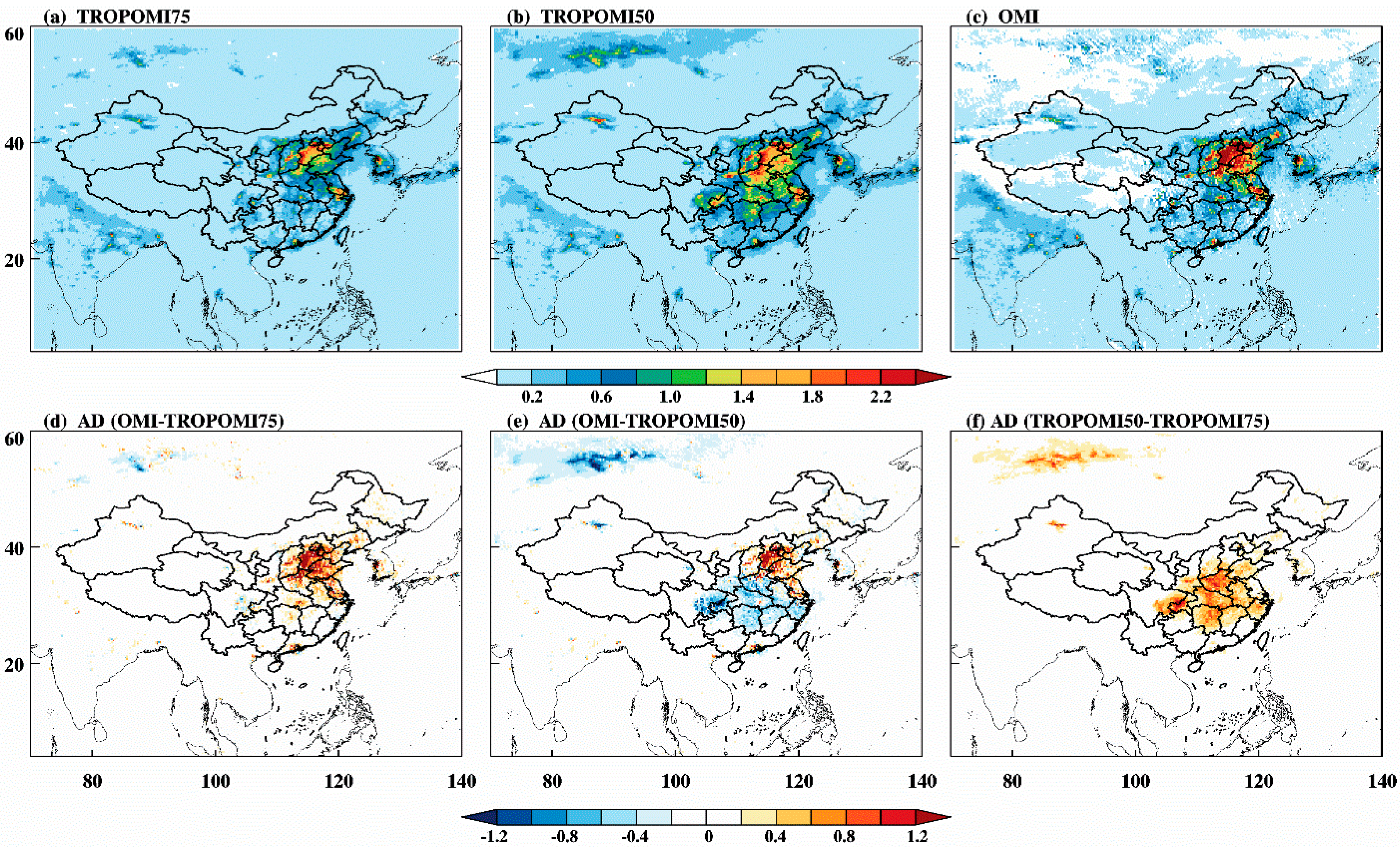
Figure 2 shows the monthly mean NO2 fields of TROPOMI and OMI retrievals and their absolute difference over China (4° N–60° N, 70° E–140° E), which were exemplary for November 2018. The absolute difference ( A D ) is defined as in Equation (3):
A D = V C D O M I V C D T R O P O M I
Evidently, both retrievals from TROPOMI and OMI exhibit a distinct spatial pattern, with high NO2 loadings in Eastern China in November and especially in the North China Plain (NCP). The TROPOMI produces smoother fields than OMI because it has more pixels. In contrast, the OMI product shows more missing values over Western China. Furthermore, the NO2 is generally higher in OMI than in TROPOMI over the NCP, both in TROPOMI75 and TROPOMI50, as reflected in Figure 2d,e, with the absolute differences being greater than 0.6 × 10¹⁶ molecules cm2 (molec cm−2). Notably, obvious differences occurred in Southern China between TROPOMI75 and TROPOMI50 (Figure 2f), where higher values were observed in TROPOMI50 than TROPOMI75, indicating that strict filtering conditions may eliminate some low NO2 values. When considering TROPOMI50 and OMI, there were significant negative differences in Southern China, corresponding to high NO2 values measured by TROPOMI. In general, the TROPOMI shows lower tropospheric NO2 values than OMI at the national scale in November, especially in the NCP, meaning that TROPOMI may underestimate the NO2 VCDs when NO2 enhancements occur. However, the concentrations retrieved from TROPOMI away from highly polluted areas may be somewhat higher than OMI.
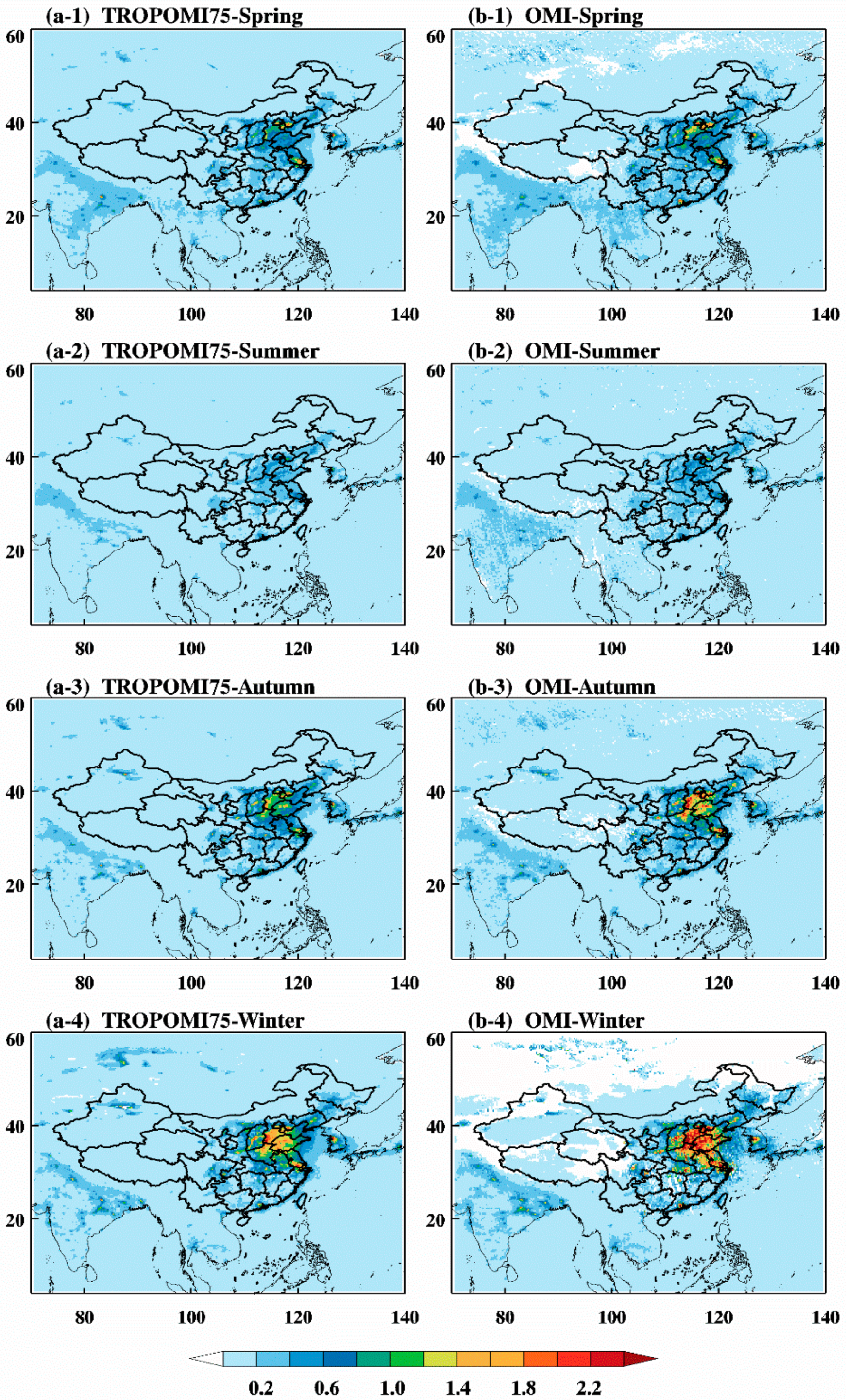
In the same way, to better explore NO2 seasonal variation and product discrepancy, the months have been grouped into four seasons, including spring (March, April and May), summer (June, July and August), autumn (September, October and November) as well as winter (December, January and February). Figure 3 illustrates the seasonal cycle of NO2 based on TROPOMI75 (a-1 to a-4) and OMI (b-1 to b-4). The NO2 concentration has a pronounced seasonal cycle over China, which is highest in winter and lowest in summer. Previous studies concluded that the seasonal variation in the lifetime of NOx depends strongly on the photolysis rates, which is a function of sun angle [38,39]. In reality, the seasonal cycle in NO2 is also affected by seasonal variations in anthropogenic emissions and meteorological conditions, but these are assumed to be of secondary importance [4,40]. At the same time, the two products show very similar NO2 spatial structure and seasonal evolution and both can highlight highly contaminated regions. Furthermore, a substantial difference is found in winter and autumn compared to the other two seasons. The significant discrepancies exceeding 0.6 × 10¹⁶ molec cm−2 are found over Jing-Jin-Ji region centered at Beijing, Tianjin and Tangshan. Besides, it is also the case in the Yangtze River Delta and Chengdu–Chongqing district during wintertime.
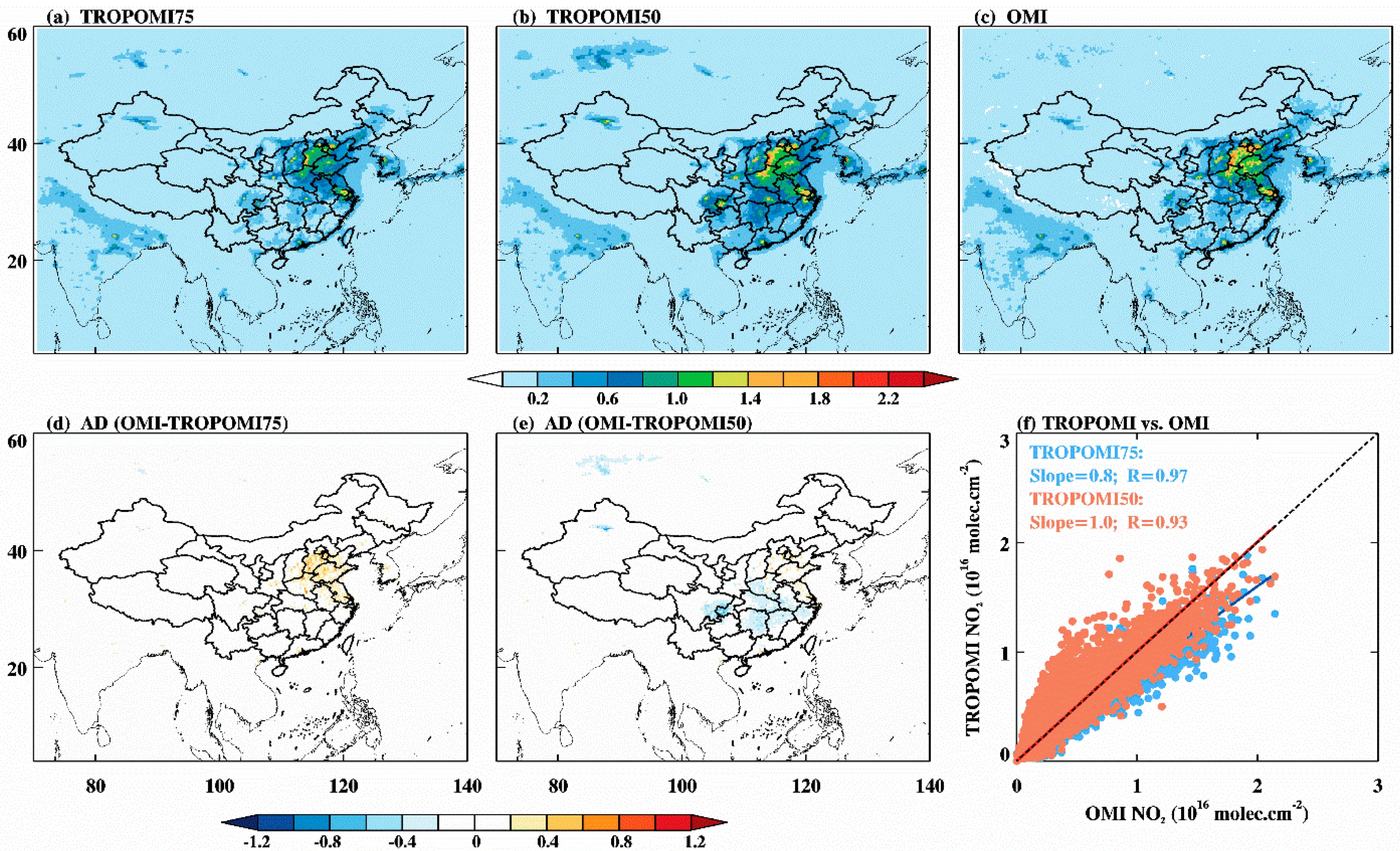
In what follows, the annual means of the NO2 VCDs over China from February 2018 to January 2019, as observed by TROPOMI and OMI respectively, are shown in Figure 4a–c. In terms of annual average, the spatial pattern from TROPOMI bears a great resemblance to that from OMI, with NO2 VCDs varying from 0.02 to 2.20 (×1016 molec cm−2) for the whole of China. High NO2 loadings are mainly located over the North China and Yangtze River Delta as a consequence of the combined effects of both human activities and natural causes [28,41]. However, the OMI measures more NO2 than TROPOMI over the high pollution areas such as the NCP, where the difference is about 0.40 (×1016 molec cm−2) with TROPOMI75 and about 0.20 (×1016 molec cm−2) with TROPOMI50, as shown in Figure 4d–e. This result based on an annual basis is similar to that on a seasonal basis mentioned above. Moreover, the NO2 VCD retrieved from TROPOMI50 in southern China is higher than OMI, with the absolute difference of −0.4 (×1016 molec cm−2). Explanations for this difference may result from the restrictions in the different satellite sensors and algorithms. For instance, the instrument issues and the quality of the level 1 data may affect the retrieval of NO2 SCDs and their uncertainties [34], such as available spectral coverage and wavelength calibration. For another example, satellite remote sensing of NO2 is frequently hindered by the cloud contamination, and thereby, cloud-screening is one of crucial steps in NO2 retrieval. TROPOMI NO2 retrieval is prone to be influenced by strict cloud mask (called FRESCO-S), which presumably exclude some heavy pollution events in the retrievals and leads to the underestimation of inversion results [32]. As shown by Boersma et al. [42], exclusion of cloudy scenes in the validation dataset between OMI and SCIAMACHY decreases NO2 concentrations by 15% on average, but does not affect the seasonal variation. In the TROPOMI processor, clouds are characterized by using cloud fraction and cloud top height parameters, which are both derived from radiance observations in the O2 A-band and used as an input in a cloud-correction scheme in NO2 retrieval [43]. Therefore, the presence of clouds can strongly affect the retrieval results. Like clouds, aerosol is also a potential influence which can affect the accuracy of tropospheric NO2 retrieval. Aerosol-related errors are intimately coupled to cloud parameter errors. The O2 A-band cloud algorithm currently does not correct for the presence of aerosols, which means aerosols are not explicitly treated in the TROPOMI NO2 algorithm (all AMF calculations being performed for a Rayleigh atmosphere) [43]. Furthermore, Figure 4f shows the scatter diagram of NO2 annual means between the two products over the study region. The linear regression yields a slope of 0.8 and spatial correlation coefficient (R) of about 0.97 between TROPOMI75 and OMI. For the comparison between TROPOMI50 and OMI, it is also well-correlated with the slope of 0.8 and R of 0.93. Note that the dots denote the pixels excluded invalid values over the study area in Figure 4a–c. Therefore, TROPOMI and OMI show good agreement in terms of temporal pattern, but the magnitudes in the TROPOMI are generally smaller than in the OMI data.

3.1.2. Analysis over the Jing-Jin-Ji Region

As mentioned before, Jing-Jin-Ji region is an economic mega-urban zone in East China, but at the same time, it suffers from high environmental pollution as well. Thus, the hotspot has been highlighted and will be specifically examined in this section. Specifying that the rest of the analysis focuses on a comparison to TROPOMI75, Figure 5 depicts the daily and monthly NO2 measured by TROPOMI and OMI over the Jing-Jin-Ji region. Observations for a single day, 22 January 2019, are shown in Figure 5a,b. TROPOMI offers higher quality and finer details of NO2. OMI, by contrast, shows fewer effective pixels and does a poor job of capturing local details due to its row anomaly and low resolution. As regards OMI, therefore, multiple days’ or months’ average is essential to obtain reliable estimates. To this end, we average TROPOMI and OMI tropospheric NO2 fields over a 0.25° × 0.25° grid cell and depict the monthly mean NO2 VCD for January 2019 (Figure 5c,d). It is noteworthy that TROPOMI exhibits clear and structural features of NO2 distribution, with elevated NO2 column densities detected in the southwest part and some urban centers. However, OMI provides more uniform spatial distribution and contains lots of noise grids, which to some extent is unable to unravel spatial diversity. Moreover, the absolute difference between the two datasets is apparent in Figure 5e. The difference between mean NO2 value of OMI (1.38) and TROPOMI (1.00) reaches 0.38 (×1016 molec cm−2). NO2 VCDs derived from TROPOMI are obviously lower than OMI over this region, especially in the southern area with high NO2 loadings (blue box highlighted in Figure 5e). If the domain turns from Jing-Jin-Ji to the area marked in the blue box, the correlation coefficient deteriorates substantially from 0.87 to 0.58. Therefore, the smaller the spatial scale, the more significant the difference between TROPOMI and OMI.
Furthermore, we present a quantitative comparison between time series of averaged NO2 retrievals from two datasets and the statistics are listed in Table 1. Overall, over the chosen area, tropospheric NO2 retrievals illustrated the high degree of temporal consistency between the two datasets in four seasons and individual months, as suggested by R. Meanwhile, the NO2 VCDs from the two datasets both indicated a pronounced seasonal fluctuation. The highest NO2 concentration appears in winter, followed by autumn. The difference of the two datasets implies the same seasonal behavior, with the maximum value occurring in winter (0.31 × 10¹⁶ molec cm−2) and the minimum in summer (0.05 × 10¹⁶ molec cm−2). These results indicate that the discrepancy between TROPOMI and OMI measurements over the Jing-Jin-Ji region is significant during all seasons, and particularly marked during winter and autumn. Lorente et al. [44] performed an experiment and concluded that the AMF structural uncertainty is to be 42% over polluted regions and 31% over unpolluted regions, mostly driven by substantial differences in the a priori trace gas profiles, surface albedo and cloud parameters. Therefore, the discrepancy may be more evident in the season with NO2 enhancement. For the comparisons of monthly averages, differences range from 0.03 to 0.56 (×1016 molec cm−2) and correlations are above 0.85, again confirming their spatial similarity, but with deviations in magnitude. In addition, on the annual basis, the mean value of TROPOMI was about 0.57 (×1016 molec cm−2), which was smaller than that of the corresponding OMI data by 0.74 (×1016 molec cm−2). Meanwhile, the correlation coefficient (R = 0.98) was extremely high throughout the whole year from February 2018 to January 2019.
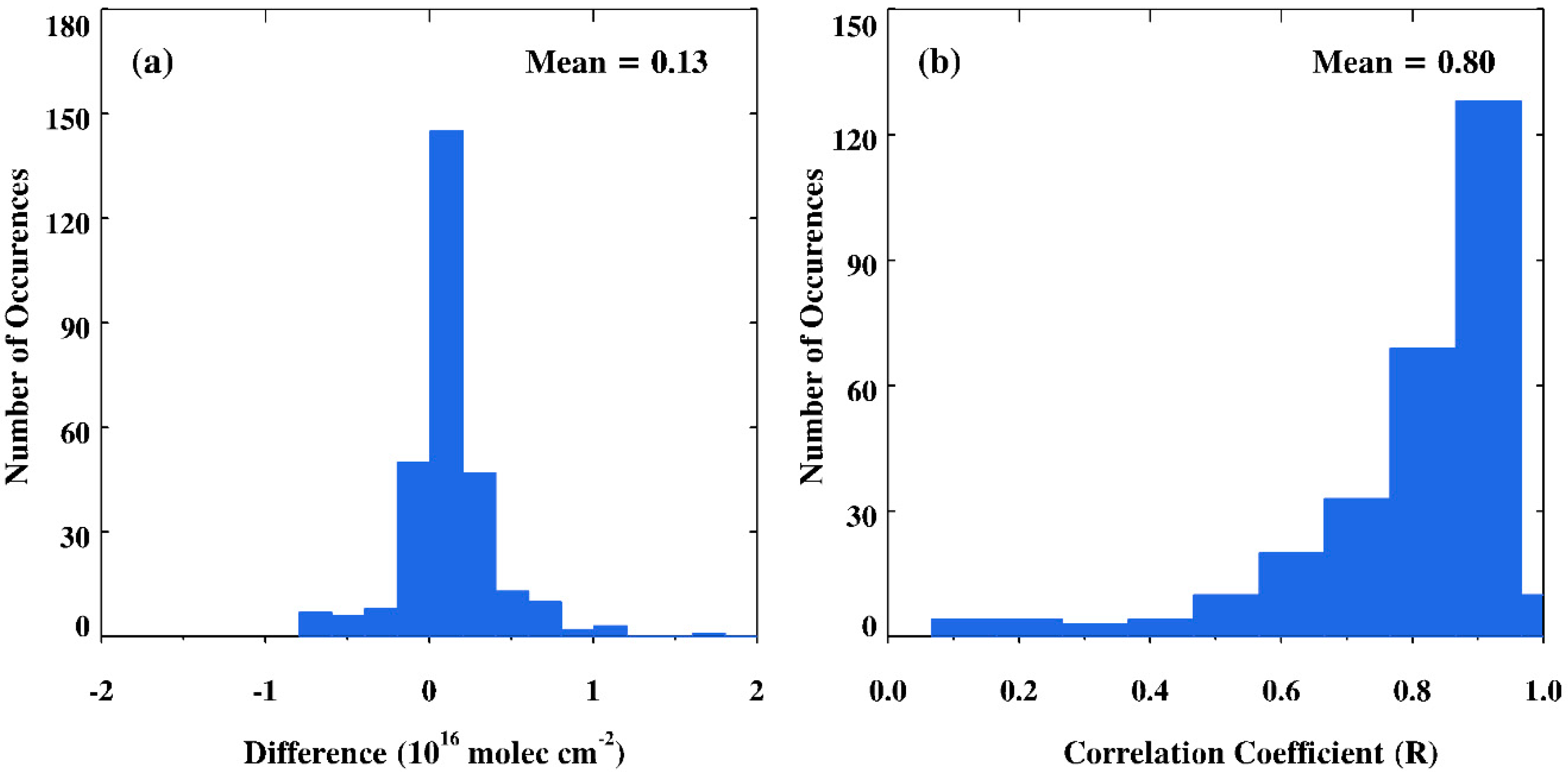
Figure 6 shows histograms derived from the daily comparison of tropospheric NO2 VCDs observed by TROPOMI and OMI over the Jing-Jin-Ji region during the measurement period. The absolute difference (OMI–TROPOMI) ranges from −1 to 2 (×1016 molec cm−2) with the mean value of 0.13 (×1016 molec cm−2), and nearly 2/3 of the values (65.6%) are between −0.2 and 0.2 (×1016 molec cm−2). Meanwhile, approximately 76.9% of OMI values are greater than TROPOMI. The positive difference mainly appears in winter and autumn, while the opposite often occurs in summer and spring. In addition, the mean R value is 0.80 and about 80.3% of days show R above 0.70, and only 6% are below 0.50. Lowest correlations are usually due to fewer pixels or the influence of clouds. For instance, the pixels covered by cloud contamination or OMI records influenced by row anomaly could lead to low correlations. These results confirm that most of the time, the TROPOMI agrees very well with OMI on patterns.
Briefly, at the national and regional scale, the TROPOMI and OMI NO2 VCDs agree well in terms of spatiotemporal structure over China. However, the magnitudes in the OMI are generally larger than in the TROPOMI data by 20% to 30%, especially over highly polluted regions and during winter and autumn. Further, TROPOMI offers higher quality and finer details of NO2, but OMI does a poor job of capturing spatial diversity at the local scale along with substantial missing value problems.

3.2. Validation against Ground-Based MAX-DOAS Measurements

3.2.1. Diurnal Variations

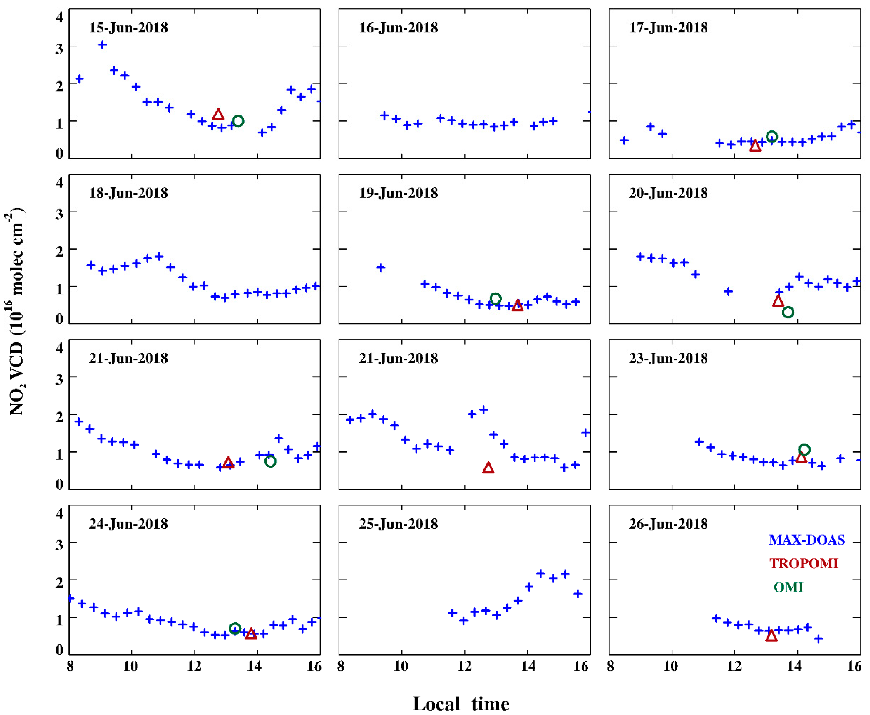
In this section, the MAX-DOAS instrument is used to assess the skill of the TROPOMI and OMI NO2 datasets in matching the ground-based observations. We selected TROPOMI and OMI columns that have a pixel center within ±0.5° latitude/longitude of the Xianghe station and are measured under mostly clear situations (cloud radiance fractions less than 50%). Figure 7 provides the day-to-day variation of tropospheric NO2 levels inferred from satellite and ground-based measurements. From 15 to 26 June 2018, a complete picture during 08:00 to 16:00 local time was created by MAX-DOAS, as shown in Figure 7. Meanwhile, the open triangles and circles denote the collocated TROPOMI and OMI measurements, respectively. TROPOMI measurements are often in good agreement with OMI. The satellite values, for the most part, are fairly close to the MAX-DOAS observations. As for the characteristics of NO2 variations illustrated in Figure 7, the daily cycle is highly variable from day to day, depending on several factors, including the diurnal cycle of NOx emissions, the change of meteorological conditions as well as the photochemical reactions of NOx [17]. Among them, sun angle, boundary layer height and wind speeds are the main meteorological drivers. Meanwhile, the elevated NO2 column densities are particularly pronounced during the morning rush hour, which is due to the heavy transportation emissions during the peak hours to some extent, beyond that, low-boundary layer heights in the morning are also a reason for the increased NO2 during the morning hours [45]. It should be mentioned that the satellite overpass times generally occur just after the midday maximum in NO2 concentration, which may influence the range of NO2 values explored in the follow-up comparison to some extent.
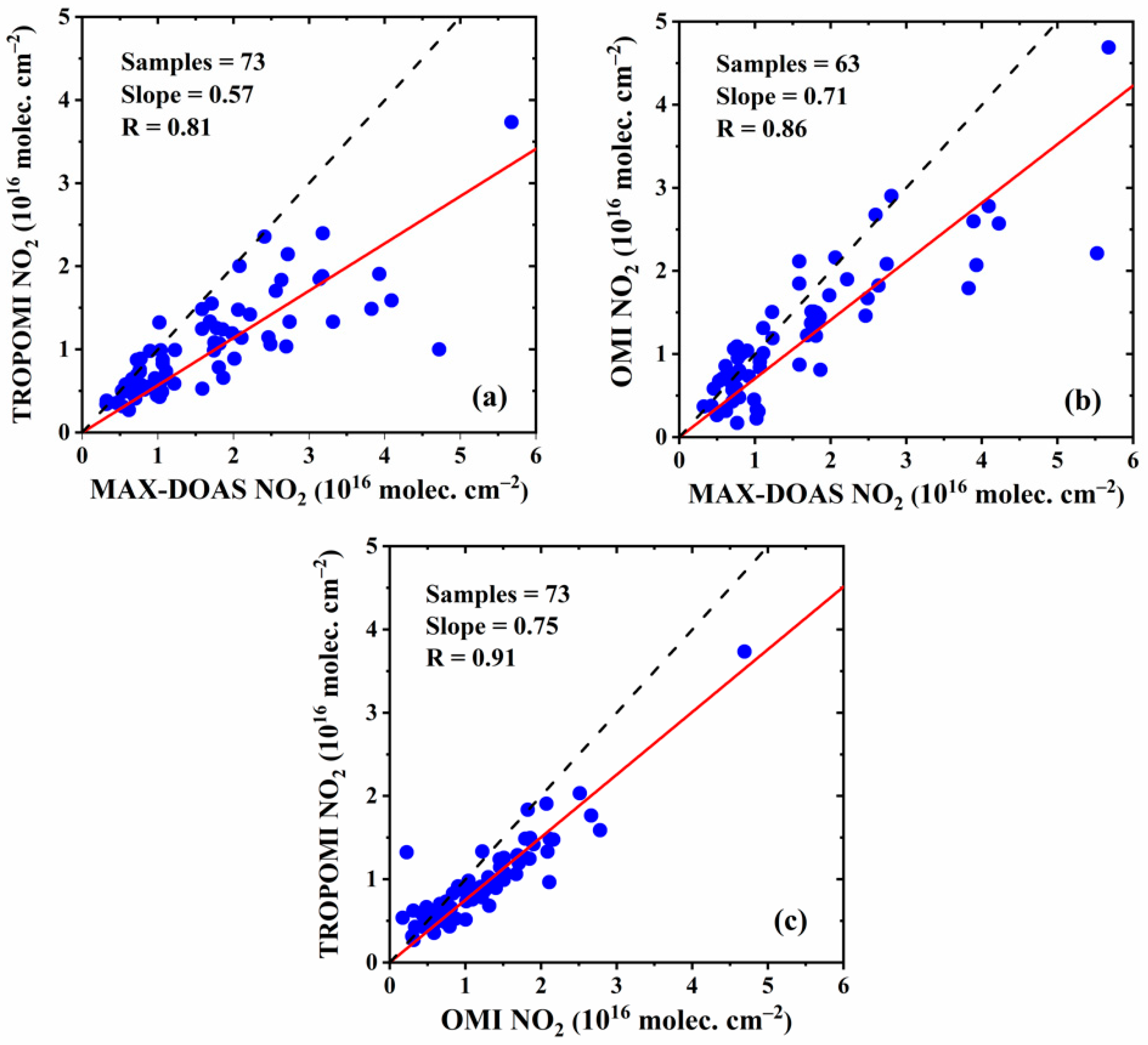
The daily comparisons between the satellite- and ground-based measurements are quantitatively illuminated in the corresponding scatterplots (Figure 8). The MAX-DOAS data are averaged within 12:30 to 14:30 local time, which covered the satellite overpass time to ensure meaningful comparisons with the satellite measured values. According to the R values, on the one hand, quite good agreements were found among the three datasets. OMI data has a close relationship with the MAX-DOAS (R = 0.86) that is slightly higher than TROPOMI versus MAX-DOAS (R = 0.81). In addition, the R between TROPOMI and OMI daily observations is as high as 0.91 (samples = 73) during the 5-month period. On the other hand, the linear regression lines are made to compare the amplitude of the different datasets and gave the following results: regression slope = 0.57 for TROPOMI and regression slope = 0.71 for OMI. Therefore, it can be found that the satellite retrievals from TROPOMI and OMI tend to underestimate tropospheric NO2 values over the Jing-Jin-Ji region by 30% to 50%, with OMI being less biased. There are several factors that may account for these findings. First, the MAX-DOAS concentrations are a focused path through a polluted area, whereas the satellite pixel is a spatially broad area that combines highly polluted and less polluted paths. Additionally, as we know, to convert a slant column to the corresponding vertical column, the influence of the light path and the corresponding parameters are calculated and expressed as AMF. The uncertainty in the estimate of the tropospheric AMF is the largest source of uncertainty in NO2 satellite retrievals in situations with enhanced trace gas concentrations. Cloud fraction, aerosol characterization, surface albedo and profile shape are all important influential factors associated with the AMF computation [18]. Therefore, when the AMF is computed using a high-resolution chemical transport model, the tropospheric vertical column amount can be increased by large amounts.
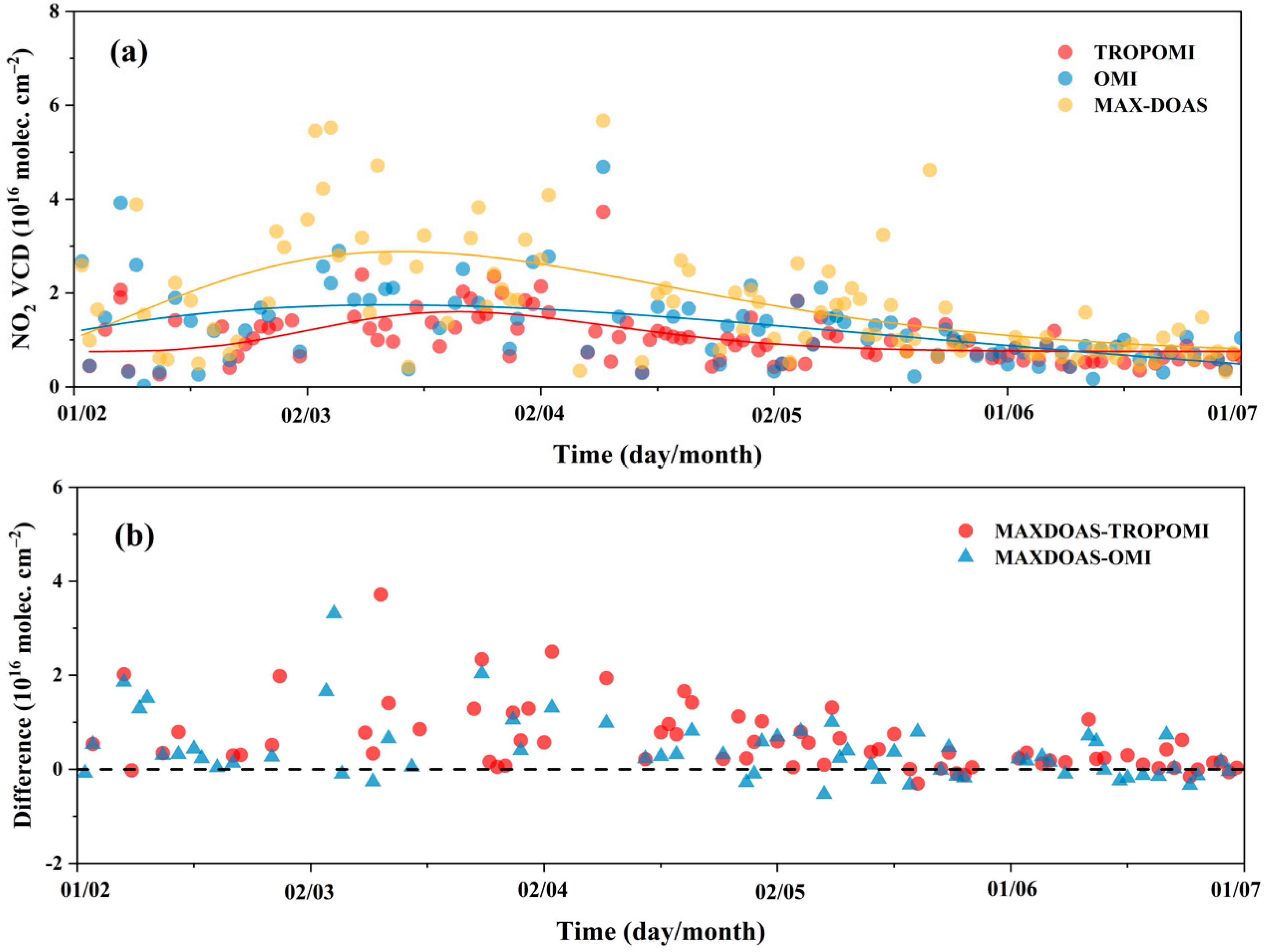
The time series of NO2 columns derived from the three datasets and their direct differences are displayed in Figure 9. The direct bias between the MAX-DOAS NO2 concentrations and the satellite NO2 columns at Xianghe station is noticeable. The ground MAX-DOAS NO2 columns are larger than the corresponding TROPOMI and OMI values covering the research period, since most of the difference values (ground-based minus satellite-based) are positive. This confirms that both daily mean TROPOMI and OMI NO2 are negatively biased relative to MAX-DOAS over this region. Moreover, the difference values are closer to 0 from May to July than other months. As mentioned before, the NO2 product of TROPOMI and OMI both show some agreement at low values, while it has obvious discrepancies for episodes of NO2 enhancement. This is due to the AMF computed with a low-resolution priori NO2 profiles, among other potential factors. Goldberg et al. [46] also shows that high-resolution models in NO2 retrieval could simulate larger concentrations near the surface in urban areas.

3.2.2. Monthly Variations

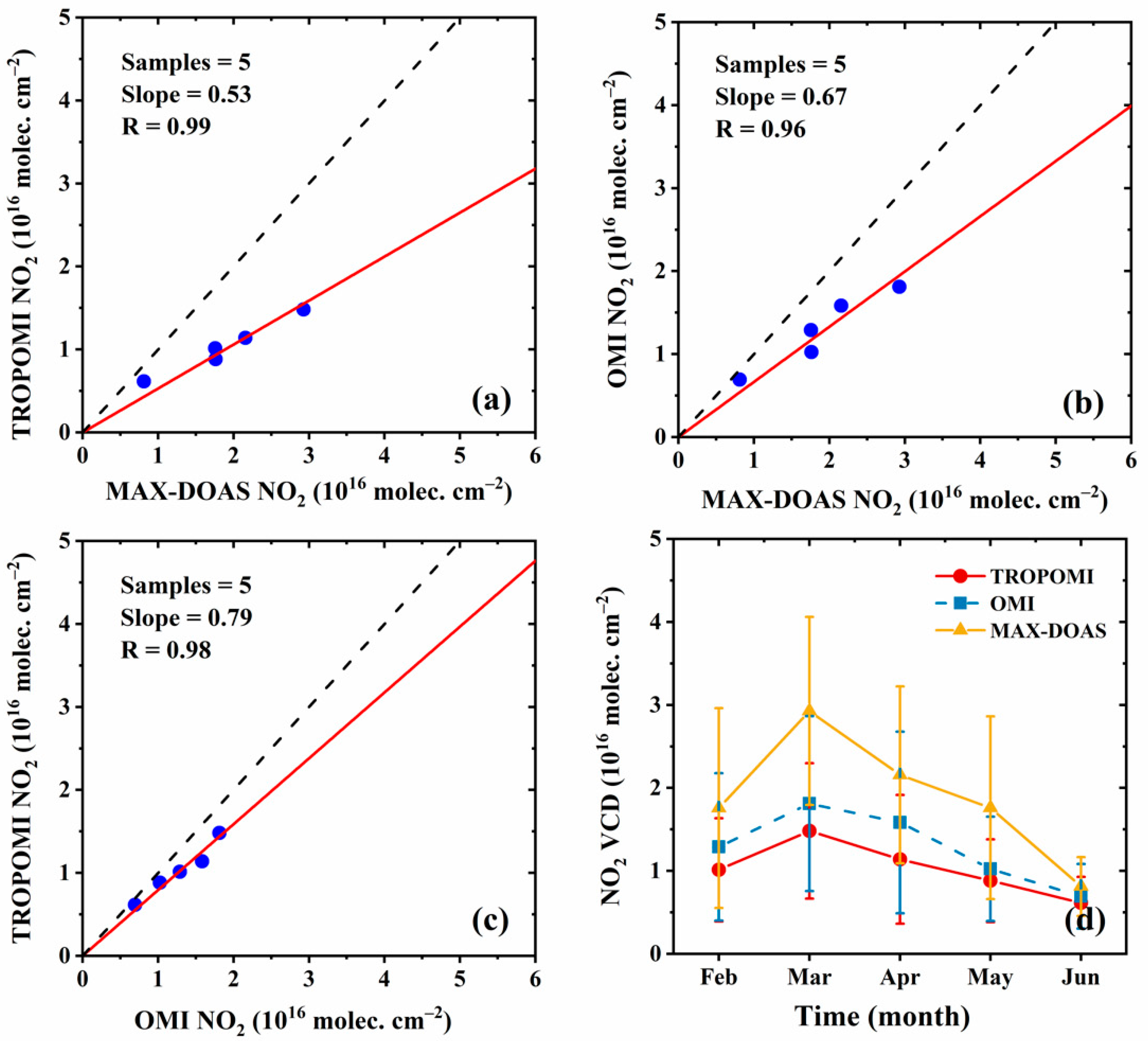
To minimize the uncertainties associated with natural and instrument noise, monthly averages are further employed in these comparisons. Figure 10a–c displays the relation plots between the monthly mean satellite-measured and ground-based-measured NO2 VCDs. Excellent linear agreement was seen between the TROPOMI and MAX-DOAS, with the R reaching about 0.99. It is also shown that OMI and MAX-DOAS NO2 were well-correlated (R = 0.96). However, the slopes between satellite- and ground-based data deviate from the unity line, again confirming that the satellite underestimates the signal in reference to MAX-DOAS.
In Figure 10d, the monthly mean values are plotted. Both OMI and TROPOMI tropospheric NO2 columns are systematically lower than the MAX-DOAS results, and the biases seem to be proportional to the NO2 VCD magnitude [21,47]. Specifically, OMI data are 32.0% lower than the MAX-DOAS data on average, and TROPOMI data are generally 45.5% smaller than MAX-DOAS. Such negative bias is possibly induced by the unrealistic a priori assumptions used in the calculation of AMF, as already noted, a key parameter in the retrieval algorithm [16,34]. For the TROPOMI NO2 retrieval algorithm, the NO2 vertical profiles are specified by the TM5-MP model, for 34 vertical layers at the horizontal resolution of 1° × 1° in latitude–longitude, which are very coarse and cannot express spatial gradients at the scale of a city. As shown by Ialongo et al. [33], replacing the coarse a priori NO2 profiles with high-resolution profiles from the Copernicus Atmosphere Monitoring Service (CAMS) chemical transport model of the AMF could improve the agreement between TROPOMI and ground-based Pandora total columns over regions with NO2 enhancement (from −28.5 ± 3.3% for TM5-MP to −23.7 ± 3.5% for CAMS). A similar investigation has also been reported by Dimitropoulou et al. [43]. They generated a modified version of the TROPOMI tropospheric NO2 VCDs using the daily-averaged MAX-DOAS concentration profiles. The change in NO2 profile shape has a strong impact on validation results, leading to a better agreement between satellite and ground-based MAX-DOAS data. On average, the TROPOMI results have been increased by about 50% compared to previous validation after their recalculation. This suggests that using high-resolution input will improve the tropospheric AMF, and as such, the tropospheric NO2 VCDs for satellite retrieval. Nevertheless, it is also worth noting that the R between satellite- and ground-based datasets are quite good in all cases. Finally, it should be noted that successive efforts are required due to a limited number of samples on monthly scales.

4. Conclusions

In this work, the first year of the tropospheric NO2 product from TROPOMI was compared with OMI and validated against the ground MAX-DOAS instrument, in order to evaluate their applicability for air quality monitoring, especially in the highly polluted Jing-Jin-Ji region. The major conclusions are summarized below.
(1) At the nationwide scale, the tropospheric NO2 column derived from TROPOMI produces consistent spatial NO2 patterns to OMI, with correlation coefficient above 0.93. Moreover, both datasets could capture monthly and seasonal cycles of NO2 equally well. However, the magnitude of NO2 is generally lower in TROPOMI than in OMI by 20% to 30%, and the absolute difference is prominent over the high-pollution areas, such as the Jing-Jin-Ji region and the Yangtze River Delta and during winter and autumn, exceeding 0.6 × 10¹⁶ molec cm−2. However, the NO2 concentrations retrieved from TROPOMI in Southern China may be somewhat higher than OMI.
(2) When it comes to the local-scale Jing-Jin-Ji hotspot, TROPOMI manifests high quality and exhibits clear and structural features of NO2 distribution, indicating a significantly better performance of representing spatial variability. That is, the TROPOMI observations are more likely to reveal NO2 information at a local and regional scale. In contrast, OMI provides more uniform spatial distribution and contains lots of noise grids, which to some extent is unable to unravel spatial diversity. If the regional mean is considered, the two datasets are highly consistent for the annual and monthly average of NO2 columns (R > 0.85), while TROPOMI produces lower NO2 content and this discrepancy is more outstanding for high NO2 loadings. Meanwhile, both the datasets indicate a similar seasonal fluctuation with the highest value during winter and the lowest during summer. At the same time, the difference implies the same seasonal behavior, which is most striking in the winter (0.31 × 10¹⁶ molec cm−2) and is close to each other in the summer (0.05 × 10¹⁶ molec cm−2). In over-polluted areas, the differences are possibly due to the uncertainties in the cloud and aerosol characterization and surface albedo used for the retrievals. They are all important parameters which have significant influences on satellite tropospheric NO2 AMFs. For NO2 retrieval, aerosols and clouds can both mask some of the tropospheric NO2, hence introducing inaccuracies in the retrieved columns.
(3) Finally, we have conducted the comparison between the satellite data and ground-based measurements at Xianghe site. It turns out that both OMI and TROPOMI underestimate the observations by ranging from 30% to 50%, with OMI being less biased. In spite of the negative drift, the temporal structures of changes derived from OMI and TROPOMI closely match the ground-based records, since the R values are above 0.8 and 0.95 for daily and monthly scales, respectively.
In summary, TROPOMI has a much finer footprint than any previous satellite instruments, which could provide NO2 observations with improved spatial resolution and low instrumental noise. Most of the time, the TROPOMI agrees very well with OMI on patterns; however, the NO2 values derived from TROPOMI are generally underestimated compared with OMI and MAX-DOAS measurements when NO2 loadings are high. Thus, further investigations are needed to examine the causes of these differences and propose improvement of the NO2 inversion over China.

Author Contributions

Conceptualization, C.W. and T.W.; Formal analysis, C.W.; Supervision, T.W., P.W. and V.R.; Validation, C.W.; Writing—original draft, C.W.; Writing—review & editing, T.W., P.W. and V.R. All authors have read and agreed to the published version of the manuscript.

Funding

This research was financially supported by the National Key R&D Program of China (Nos. 2017YFB0504000 and 2017YFC1501701) and the National Natural Science Foundation of China (No. 41975035).

Acknowledgments

We thank KNMI for providing the TROPOMI and OMI tropospheric NO2 data, which is available at http://www.temis.nl. We are thankful to Wannan Wang and Lin Tian for providing the technical support. We are also thankful to the editor and anonymous reviewers for their valuable comments that have helped us to enhance the quality of the manuscript.

Conflicts of Interest

The authors declare no conflict of interest.

References

  1. WHO. Air quality guidelines: Global update 2005. Particulate matter, ozone, nitrogen dioxide and sulfur dioxide. Indian J. Med. Res. 2007, 4, 492–493. [Google Scholar]
  2. Boersma, K.F.; Eskes, H.J.; Brinksma, E.J. Error analysis for tropospheric NO2 retrieval from space. J. Geophys. Res. Atmos. 2004, 109. [Google Scholar] [CrossRef]
  3. van der A, R.J.; Eskes, H.J.; Boersma, K.F.; van Noije, T.P.C.; Van Roozendael, M.; De Smedt, I.; Peters, D.H.M.U.; Meijer, E.W. Trends, seasonal variability and dominant NOx source derived from a ten year record of NO2 measured from space. J. Geophys. Res. 2008, 113. [Google Scholar] [CrossRef]
  4. van der A, R.J.; Peters, D.H.M.U.; Eskes, H.; Boersma, K.F.; Van Roozendael, M.; De Smedt, I.; Kelder, H.M. Detection of the trend and seasonal variation in tropospheric NO2 over China. J. Geophys. Res. Atmos. 2006, 111. [Google Scholar] [CrossRef] [Green Version]
  5. Schneider, P.; van der A, R.J. A global single-sensor analysis of 2002-2011 tropospheric nitrogen dioxide trends observed from space. J. Geophys. Res. Atmos. 2012, 117. [Google Scholar] [CrossRef] [Green Version]
  6. Schneider, P.; Lahoz, W.A.; van der A, R. Recent satellite-based trends of tropospheric nitrogen dioxide over large urban agglomerations worldwide. Atmos. Chem. Phys. 2015, 15, 1205–1220. [Google Scholar] [CrossRef] [Green Version]
  7. Lü, C.; Tian, H. Spatial and temporal patterns of nitrogen deposition in China: Synthesis of observational data. J. Geophys. Res. 2007, 112. [Google Scholar] [CrossRef]
  8. Nowlan, C.R.; Martin, R.V.; Philip, S.; Lamsal, L.N.; Krotkov, N.A.; Marais, E.A.; Wang, S.; Zhang, Q. Global dry deposition of nitrogen dioxide and sulfur dioxide inferred from space-based measurements. Glob. Biogeochem. Cycles 2014, 28, 1025–1043. [Google Scholar] [CrossRef] [Green Version]
  9. Steffen, B.; K Folkert, B.; Ulrich, P.; Lawrence, M.G.; Thomas, W. Megacity emissions and lifetimes of nitrogen oxides probed from space. Science 2011, 333, 1737–1739. [Google Scholar]
  10. Lin, J.T.; McElroy, M.B. Detection from space of a reduction in anthropogenic emissions of nitrogen oxides during the Chinese economic downturn. Atmos. Chem. Phys. 2011, 11, 8171–8188. [Google Scholar] [CrossRef] [Green Version]
  11. Liu, F.; Beirle, S.; Zhang, Q.; Rj, V.D.A.; Zheng, B.; Tong, D.; He, K. NOx emission trends over Chinese cities estimated from OMI observations during 2005 to 2015. Atmos. Chem. Phys. 2017, 17, 9261. [Google Scholar] [CrossRef] [Green Version]
  12. Gu, J.; Chen, L.; Yu, C.; Li, S.; Tao, J.; Fan, M.; Xiong, X.; Wang, Z.; Shang, H.; Su, L. Ground-Level NO2 Concentrations over China Inferred from the Satellite OMI and CMAQ Model Simulations. Remote Sens. 2017, 9, 519. [Google Scholar] [CrossRef] [Green Version]
  13. Qin, K.; Rao, L.; Xu, J.; Bai, Y.; Zou, J.; Hao, N.; Li, S.; Yu, C. Estimating Ground Level NO2 Concentrations over Central-Eastern China Using a Satellite-Based Geographically and Temporally Weighted Regression Model. Remote Sens. 2017, 9, 950. [Google Scholar] [CrossRef] [Green Version]
  14. Lamsal, L.N.; Krotkov, N.A.; Celarier, E.A.; Swartz, W.H.; Pickering, K.E.; Bucsela, E.J.; Gleason, J.F.; Martin, R.V.; Philip, S.; Irie, H.; et al. Evaluation of OMI operational standard NO2 column retrievals using in situ and surface-based NO2 observations. Atmos. Chem. Phys. 2014, 14, 11587–11609. [Google Scholar] [CrossRef] [Green Version]
  15. Wenig, M.O.; Cede, A.M.; Bucsela, E.J.; Celarier, E.A.; Boersma, K.F.; Veefkind, J.P.; Brinksma, E.J.; Gleason, J.F.; Herman, J.R. Validation of OMI tropospheric NO2 column densities using direct-Sun mode Brewer measurements at NASA Goddard Space Flight Center. J. Geophys. Res. 2008, 113. [Google Scholar] [CrossRef]
  16. Dirksen, R.J.; Boersma, K.F.; Eskes, H.J.; Ionov, D.V.; Bucsela, E.J.; Levelt, P.F.; Kelder, H.M. Evaluation of stratospheric NO2 retrieved from the Ozone Monitoring Instrument: Intercomparison, diurnal cycle, and trending. J. Geophys. Res. 2011, 116. [Google Scholar] [CrossRef] [Green Version]
  17. Ialongo, I.; Herman, J.; Krotkov, N.; Lamsal, L.; Boersma, K.F.; Hovila, J.; Tamminen, J. Comparison of OMI NO2 observations and their seasonal and weekly cycles with ground-based measurements in Helsinki. Atmos. Meas. Tech. 2016, 9, 5203–5212. [Google Scholar] [CrossRef] [Green Version]
  18. Blond, N.; Boersma, K.F.; Eskes, H.J.; van der A, R.J.; Van Roozendael, M.; De Smedt, I.; Bergametti, G.; Vautard, R. Intercomparison of SCIAMACHY nitrogen dioxide observations, in situ measurements and air quality modeling results over Western Europe. J. Geophys. Res. Atmos. 2007, 112. [Google Scholar] [CrossRef] [Green Version]
  19. Konovalov, I.B.; Beekmann, M.; Vautard, R.; Burrows, J.P.; Richter, A.; Nüß, H.; Elansky, N. Comparison and evaluation of modelled and GOME measurement derived tropospheric NO2 columns over Western and Eastern Europe. Atmos. Chem. Phys. 2005, 5, 169–190. [Google Scholar] [CrossRef] [Green Version]
  20. Heue, K.P.; Richter, A.; Bruns, M.; Burrows, J.P.; van Friedeburg, C.; Platt, U.; Pundt, I.; Wang, P.; Wagner, T. Validation of SCIAMACHY tropospheric NO2-columns with AMAXDOAS measurements. Atmos. Chem. Phys. 2005, 5, 1039–1051. [Google Scholar] [CrossRef] [Green Version]
  21. Irie, H.; Boersma, K.F.; Kanaya, Y.; Takashima, H.; Pan, X.; Wang, Z.F. Quantitative bias estimates for tropospheric NO2 columns retrieved from SCIAMACHY, OMI, and GOME-2 using a common standard for East Asia. Atmos. Meas. Tech. 2012, 5, 2403–2411. [Google Scholar] [CrossRef] [Green Version]
  22. Celarier, E.A.; Brinksma, E.J.; Gleason, J.F.; Veefkind, J.P.; Cede, A.; Herman, J.R.; Ionov, D.; Goutail, F.; Pommereau, J.P.; Lambert, J.C.; et al. Validation of Ozone Monitoring Instrument nitrogen dioxide columns. J. Geophys. Res. 2008, 113. [Google Scholar] [CrossRef] [Green Version]
  23. Zheng, F.; Yu, T.; Cheng, T.; Gu, X.; Guo, H. Intercomparison of tropospheric nitrogen dioxide retrieved from Ozone Monitoring Instrument over China. Atmos. Pollut. Res. 2014, 5, 686–695. [Google Scholar] [CrossRef] [Green Version]
  24. Krotkov, N.A.; Lamsal, L.N.; Celarier, E.A.; Swartz, W.H.; Marchenko, S.V.; Bucsela, E.J.; Chan, K.L.; Wenig, M.; Zara, M. The version 3 OMI NO2 standard product. Atmos. Meas. Tech. 2017, 10, 3133–3149. [Google Scholar] [CrossRef] [Green Version]
  25. Choi, S.; Lamsal, L.N.; Follette-Cook, M.; Joiner, J.; Krotkov, N.A.; Swartz, W.H.; Pickering, K.E.; Loughner, C.P.; Appel, W.; Pfister, G.; et al. Assessment of NO2 observations during DISCOVER-AQ and KORUS-AQ field campaigns. Atmos. Meas. Tech. Discuss. 2019. [Google Scholar] [CrossRef] [Green Version]
  26. Griffin, D.; Zhao, X.; McLinden, C.A.; Boersma, F.; Bourassa, A.; Dammers, E.; Degenstein, D.; Eskes, H.; Fehr, L.; Fioletov, V.; et al. High-Resolution Mapping of Nitrogen Dioxide With TROPOMI: First Results and Validation Over the Canadian Oil Sands. Geophys. Res. Lett. 2019, 46, 1049–1060. [Google Scholar] [CrossRef] [Green Version]
  27. Wang, T.; Wang, P.; Franois, H.; Yu, H.; Michel, V. The Spatial and Temporal Variability of Tropospheric NO2 during 2005-14 over China Observed by the OMI. Atmos. Ocean. Sci. Lett. 2015, 8, 392–396. [Google Scholar]
  28. Krotkov, N.A.; Mclinden, C.A.; Li, C.; Lamsal, L.N.; Streets, D.G. Aura OMI observations of regional SO2 and NO2 pollution changes from 2005 to 2015. Atmos. Chem. Phys. 2016, 16, 4605–4629. [Google Scholar] [CrossRef] [Green Version]
  29. Wang, C.; Wang, T.; Wang, P. The Spatial–Temporal Variation of Tropospheric NO2 over China during 2005 to 2018. Atmosphere 2019, 10, 444. [Google Scholar] [CrossRef] [Green Version]
  30. Veefkind, J.P.; Aben, I.; McMullan, K.; Förster, H.; de Vries, J.; Otter, G.; Claas, J.; Eskes, H.J.; de Haan, J.F.; Kleipool, Q.; et al. TROPOMI on the ESA Sentinel-5 Precursor: A GMES mission for global observations of the atmospheric composition for climate, air quality and ozone layer applications. Remote Sens. Environ. 2012, 120, 70–83. [Google Scholar] [CrossRef]
  31. De Smedt, I.; Theys, N.; Yu, H.; Danckaert, T.; Lerot, C.; Compernolle, S.; Van Roozendael, M.; Richter, A.; Hilboll, A.; Peters, E.; et al. Algorithm theoretical baseline for formaldehyde retrievals from S5P TROPOMI and from the QA4ECV project. Atmos. Meas. Tech. 2018, 11, 2395–2426. [Google Scholar] [CrossRef] [Green Version]
  32. van Geffen, J.H.G.M.; Eskes, H.J.; Boersma, K.F.; Maasakkers, J.D.; Veefkind, J.P. TROPOMI ATBD of the Total and Tropospheric NO2 Data Products. Available online: http://www.tropomi.eu/documents/atbd/ (accessed on 10 April 2020).
  33. Ialongo, I.; Virta, H.; Eskes, H.; Hovila, J.; Douros, J. Comparison of TROPOMI/Sentinel-5 Precursor NO2 observations with ground-based measurements in Helsinki. Atmos. Meas. Tech. 2020, 13, 205–218. [Google Scholar] [CrossRef] [Green Version]
  34. Boersma, K.F.; Eskes, H.J.; Richter, A.; De Smedt, I.; Lorente, A.; Beirle, S.; van Geffen, J.H.G.M.; Zara, M.; Peters, E.; Van Roozendael, M.; et al. Improving algorithms and uncertainty estimates for satellite NO2 retrievals: Results from the quality assurance for the essential climate variables (QA4ECV) project. Atmos. Meas. Tech. 2018, 11, 6651–6678. [Google Scholar] [CrossRef] [Green Version]
  35. Wang, T.; Hendrick, F.; Wang, P.; Tang, G.; Clémer, K.; Yu, H.; Fayt, C.; Hermans, C.; Gielen, C.; Müller, J.F.; et al. Evaluation of tropospheric SO2 retrieved from MAX-DOAS measurements in Xianghe, China. Atmos. Chem. Phys. 2014, 14, 11149–11164. [Google Scholar] [CrossRef] [Green Version]
  36. Wang, T.; Wang, P.; Yu, H.; Sun, L. Analysis of the characteristics of tropospheric NO2 in Xianghe based on MAX-DOAS measurement. Clim. Environ. Res. 2014, 19, 51–60. [Google Scholar]
  37. Clémer, K.; Van Roozendael, M.; Fayt, C.; Hendrick, F.; Hermans, C.; Pinardi, G.; Spurr, R.; Wang, P.; De Mazière, M. Multiple wavelength retrieval of tropospheric aerosol optical properties from MAXDOAS measurements in Beijing. Atmos. Meas. Tech. 2010, 3, 863–878. [Google Scholar] [CrossRef] [Green Version]
  38. Richter, A.; Burrows, J.P.; Nuss, H.; Granier, C.; Niemeier, U. Increase in tropospheric nitrogen dioxide over China observed from space. Nature 2005, 437, 129–132. [Google Scholar] [CrossRef]
  39. Shah, V.; Jacob, D.J.; Li, K.; Silvern, R.F.; Zhai, S.; Liu, M.; Lin, J.; Zhang, Q. Effect of changing NOx lifetime on the seasonality and long-term trends of satellite-observed tropospheric NO2 columns over China. Atmos. Chem. Phys. 2020, 20, 1483–1495. [Google Scholar] [CrossRef] [Green Version]
  40. Wang, T.; Wang, P.; Theys, N.; Tong, D.; Hendrick, F.; Zhang, Q.; Van Roozendael, M. Spatial and temporal changes in SO2 regimes over China in the recent decade and the driving mechanism. Atmos. Chem. Phys. 2018, 18, 18063–18078. [Google Scholar] [CrossRef] [Green Version]
  41. van der A, R.J.; Mijling, B.; Ding, J.; Koukouli, M.E.; Liu, F.; Li, Q.; Mao, H.; Theys, N. Cleaning up the air: Effectiveness of air quality policy for SO2 and NOx emissions in China. Atmos. Chem. Phys. 2017, 17, 1775–1789. [Google Scholar] [CrossRef] [Green Version]
  42. Boersma, K.F.; Jacob, D.J.; Trainic, M.; Rudich, Y.; DeSmedt, I.; Dirksen, R.; Eskes, H.J. Validation of urban NO2 concentrations and their diurnal and seasonal variations observed from the SCIAMACHY and OMI sensors using in situ surface measurements in Israeli cities. Atmos. Chem. Phys. 2009, 9, 3867–3879. [Google Scholar] [CrossRef] [Green Version]
  43. Dimitropoulou, E.; Hendrick, F.; Pinardi, G.; Friedrich, M.M.; Merlaud, A.; Tack, F.; De Longueville, H.; Fayt, C.; Hermans, C.; Laffineur, Q.; et al. Validation of TROPOMI tropospheric NO2 columns using dual-scan MAX-DOAS measurements in Uccle, Brussels. Atmos. Meas. Tech. Discuss. 2020. [Google Scholar] [CrossRef]
  44. Lorente, A.; Folkert Boersma, K.; Yu, H.; Dörner, S.; Hilboll, A.; Richter, A.; Liu, M.; Lamsal, L.N.; Barkley, M.; De Smedt, I.; et al. Structural uncertainty in air mass factor calculation for NO2 and HCHO satellite retrievals. Atmos. Meas. Tech. 2017, 10, 759–782. [Google Scholar] [CrossRef] [Green Version]
  45. Song, Z.; Fu, D.; Zhang, X.; Wu, Y.; Xia, X.; He, J.; Han, X.; Zhang, R.; Che, H. Diurnal and seasonal variability of PM2.5 and AOD in North China plain: Comparison of MERRA-2 products and ground measurements. Atmos. Environ. 2018, 191, 70–78. [Google Scholar] [CrossRef]
  46. Goldberg, D.L.; Lamsal, L.N.; Loughner, C.P.; Swartz, W.H.; Lu, Z.; Streets, D.G. A high-resolution and observationally constrained OMI NO2 satellite retrieval. Atmos. Chem. Phys. 2017, 17, 11403–11421. [Google Scholar] [CrossRef] [Green Version]
  47. Jin, J.; Ma, J.; Lin, W.; Zhao, H.; Shaiganfar, R.; Beirle, S.; Wagner, T. MAX-DOAS measurements and satellite validation of tropospheric NO2 and SO2 vertical column densities at a rural site of North China. Atmos. Environ 2016, 133, 12–25. [Google Scholar] [CrossRef]
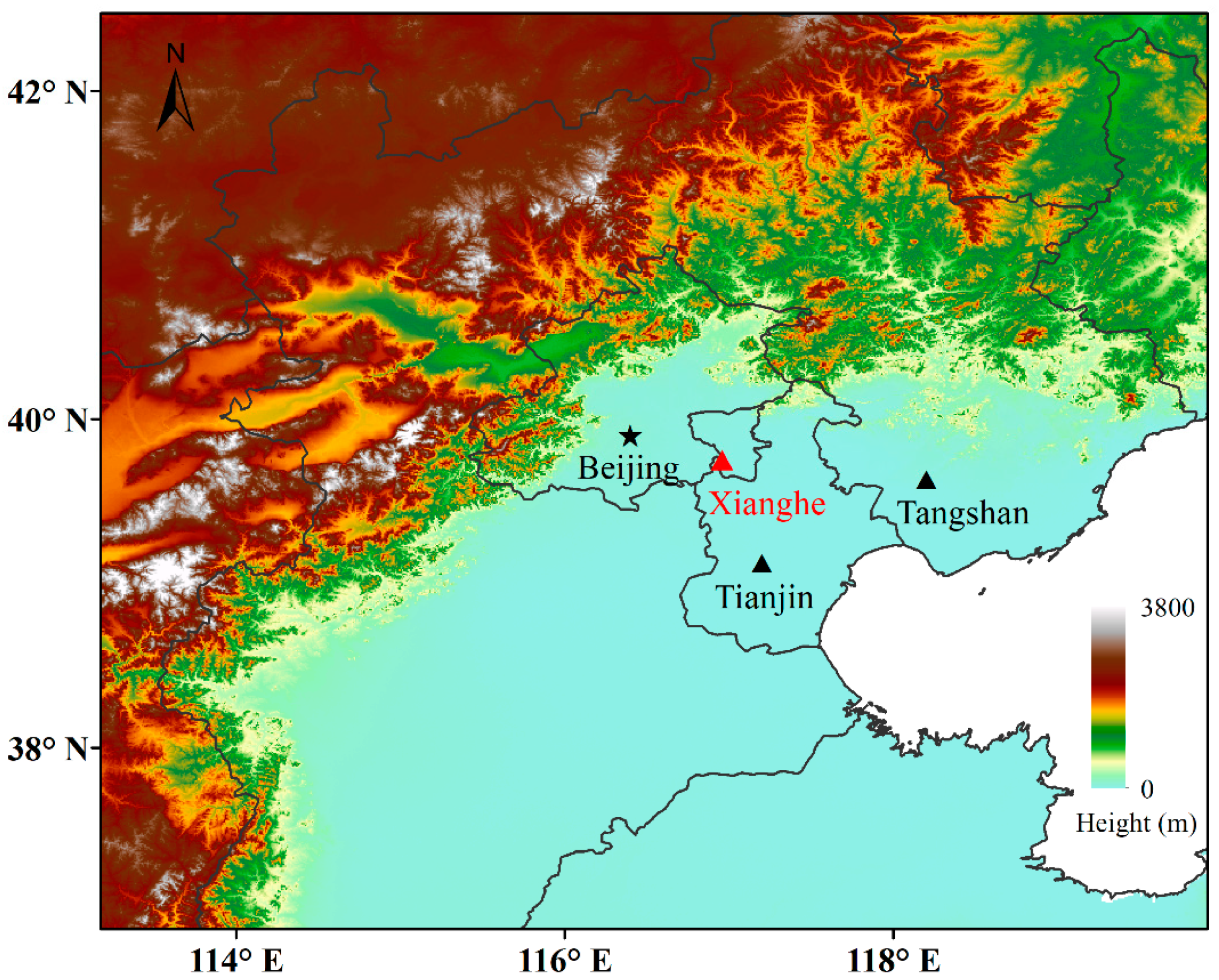
Figure 1. Terrain elevation and location of the Xianghe Station (red triangle) and other major cities.
Atmosphere 11 00636 g001
Figure 2. Exemplary monthly mean maps (0.25° × 0.25° grid) of (a) TROPOMI75, (b) TROPOMI50, (c) OMI tropospheric NO2 VCDs as well as (df) their absolute differences (AD) (units: 1016 molec cm−2) for November 2018.
Atmosphere 11 00636 g002
Figure 3. Seasonal mean tropospheric NO2 VCDs binned at 0.25° × 0.25° in spring (first row), summer (second row), autumn (third row) and winter (fourth row) over China from the (a) TROPOMI75 and (b) OMI (units: 1016 molec cm−2).
Atmosphere 11 00636 g003
Figure 4. Tropospheric NO2 distributions averaged over a period from February 2018 to January 2019 (units: 1016 molec cm−2) (a) from TROPOMI75, (b) from TROPOMI50 and (c) from OMI, along with (d–e) absolute difference maps (OMI minus TROPOMI). (f) Scatterplot of TROPOMI versus OMI annual mean tropospheric NO2 columns with regression line superimposed. The slope and correlation coefficient (R) are also shown in the plot.
Atmosphere 11 00636 g004
Figure 5. (a,b) Tropospheric NO2 measured by TROPOMI75 and OMI on 22 January 2019 over the Jing-Jin-Ji region. (c,d) The same as (a,b) but for the average of January 2019. (e) The absolute difference of OMI minus TROPOMI tropospheric NO2 columns averaged in January 2019. Blue box denotes the area with high NO2 loadings. (units: 1016 molec cm−2).
Atmosphere 11 00636 g005
Figure 6. Histograms of the (a) absolute difference and (b) correlation coefficient between daily OMI and TROPOMI75 data over the Jing-Jin-Ji region.
Atmosphere 11 00636 g006
Figure 7. Average diurnal variation of tropospheric NO2 VCDs measured by MAX-DOAS (plus symbols) during 08:00 to 16:00 local time at Xianghe station. The open triangles and circles denote the TROPOMI75 and OMI measurements for the site, respectively (units: 1016 molec cm−2).
Atmosphere 11 00636 g007
Figure 8. (a) Correlation between daily TROPOMI tropospheric NO2 columns and MAX-DOAS NO2 observations made from 1 February through 30 June 2018. (b) Same as (a), but for correlation between OMI and MAX-DOAS. (c) Same as (a), but for correlation between TROPOMI75 and OMI (units: 1016 molec cm−2).
Atmosphere 11 00636 g008
Figure 9. (a) Time series of tropospheric NO2 VCDs from February to June in 2018. Solid lines represent the fit curves of the three datasets. (b) Daily mean absolute differences between MAX-DOAS and satellite tropospheric NO2 VCDs. Blue triangles indicate MAX-DOAS minus OMI data, and red dots represent MAX-DOAS minus TROPOMI75 (unit: 1016 molec cm−2).
Atmosphere 11 00636 g009
Figure 10. (a) Correlation plot showing the collocated monthly mean TROPOMI75 tropospheric NO2 columns and MAX-DOAS NO2 measurements. (b) Same as (a), but for correlation between OMI and MAX-DOAS. (c) Same as (a), but for correlation between TROPOMI75 and OMI. (d) Monthly mean NO2 tropospheric columns based on TROPOMI75, OMI and MAX-DOAS, from February to June 2018. The error bars correspond to the standard deviation of the monthly mean tropospheric NO2 VCDs (units: 1016 molec cm−2).
Atmosphere 11 00636 g010
Table 1. Statistics describing the comparison of TROPOMI and OMI NO2 retrievals over the Jing-Jin-Ji region.
PeriodOMITROPOMIDifferenceRSlopeInterceptN
Year0.740.570.170.980.740.02841
Spring0.630.520.110.960.770.03841
Summer0.340.290.050.950.780.02841
Autumn0.860.630.230.960.670.06841
Winter1.150.840.310.940.650.09840
February0.670.570.100.900.750.08816
March0.830.620.210.910.610.11834
April0.640.540.110.900.720.07838
May0.430.400.030.940.860.03841
June0.380.340.030.920.820.03836
July0.320.260.060.850.590.07816
August0.310.250.060.860.680.04793
September0.460.410.050.850.700.09834
October0.690.610.080.930.790.06838
November1.450.890.560.930.510.15826
December1.330.950.380.890.580.18835
January1.381.000.380.870.560.22831
Note: The OMI and TROPOMI represent the NO2 mean value from OMI and TROPOMI75. Difference is OMI minus TROPOMI. R is the correlation coefficient between two datasets. Columns are in the unit of 1016 molec cm−2. Slope and intercept of the regression of TROPOMI on OMI, along with the sample size, are shown in the last three columns.