Integrating Modelling and Expert Knowledge for Evaluating Current and Future Scenario of Large Cardamom Crop in Eastern Nepal


Abstract
:
1. Introduction
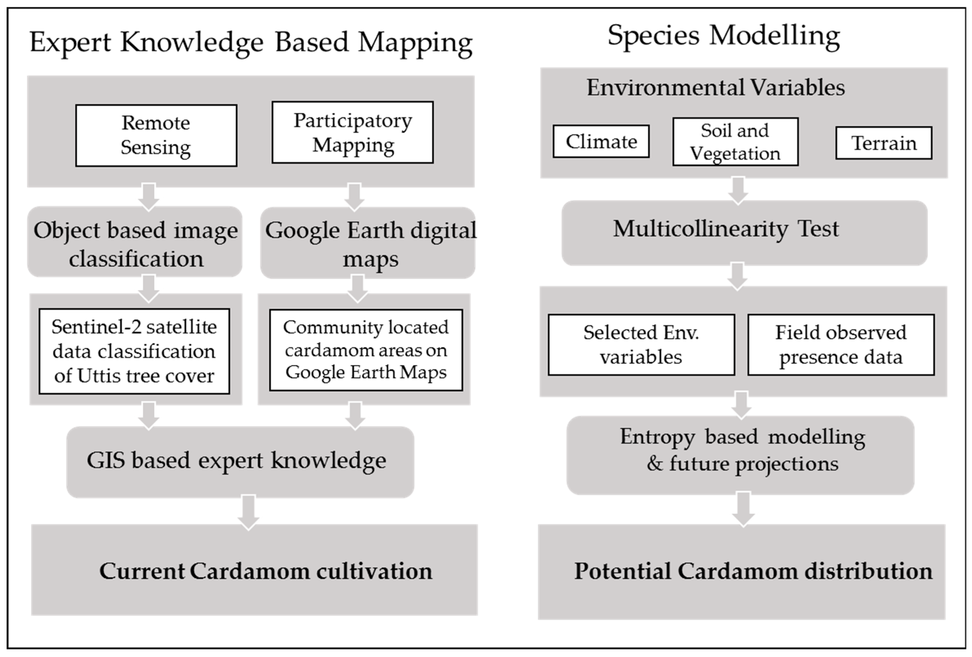
2. Materials and Methods
2.1. Study Area
2.2. Expert Knowledge-Based Mapping
2.2.1. Participatory Mapping
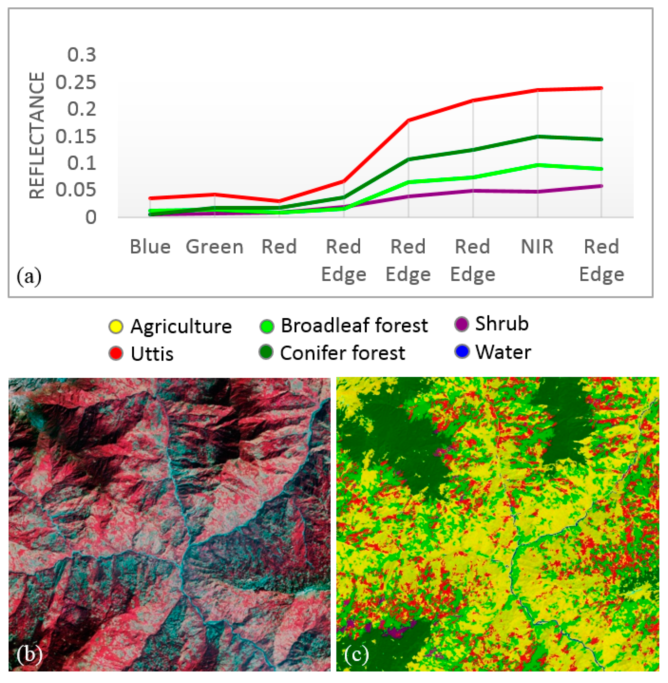
2.2.2. Uttis (Alnus nepalensis) Mapping Using High-Resolution Satellite Data
2.3. Species Modelling
2.3.1. Environmental Variables and Species Occurrence Records
2.3.2. Spatial Modelling and Statistical Analysis
3. Results and Discussions
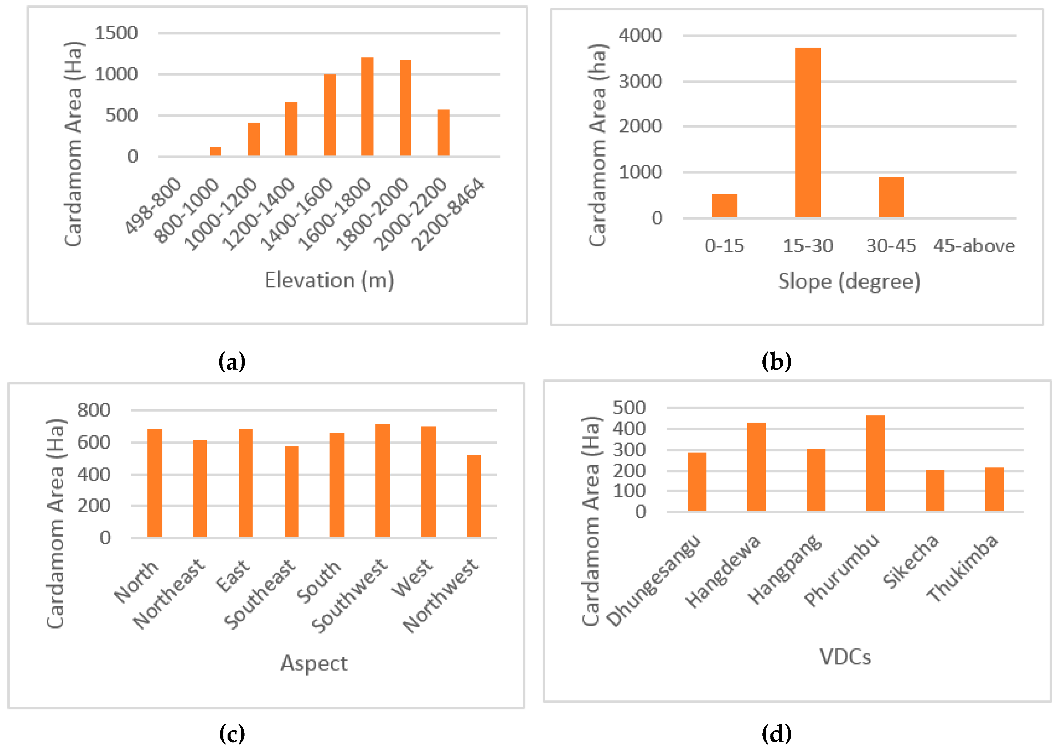
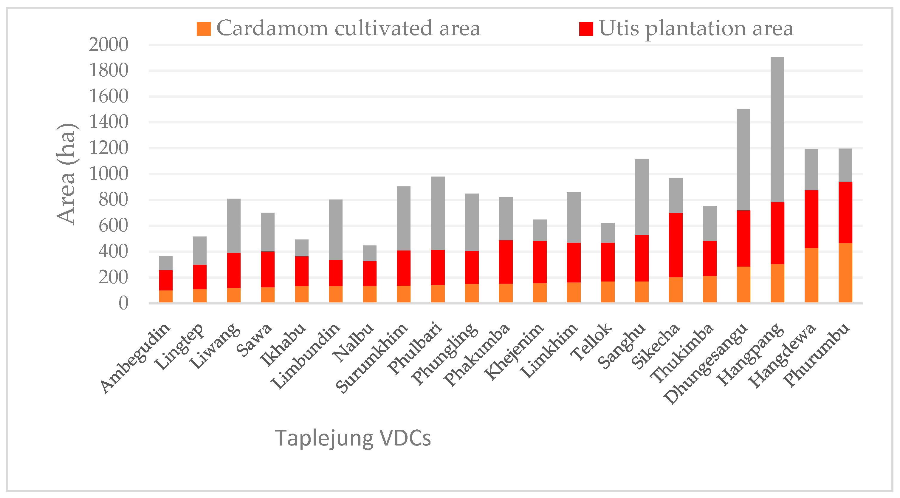
3.1. Participatory Mapping of Large Cardamom
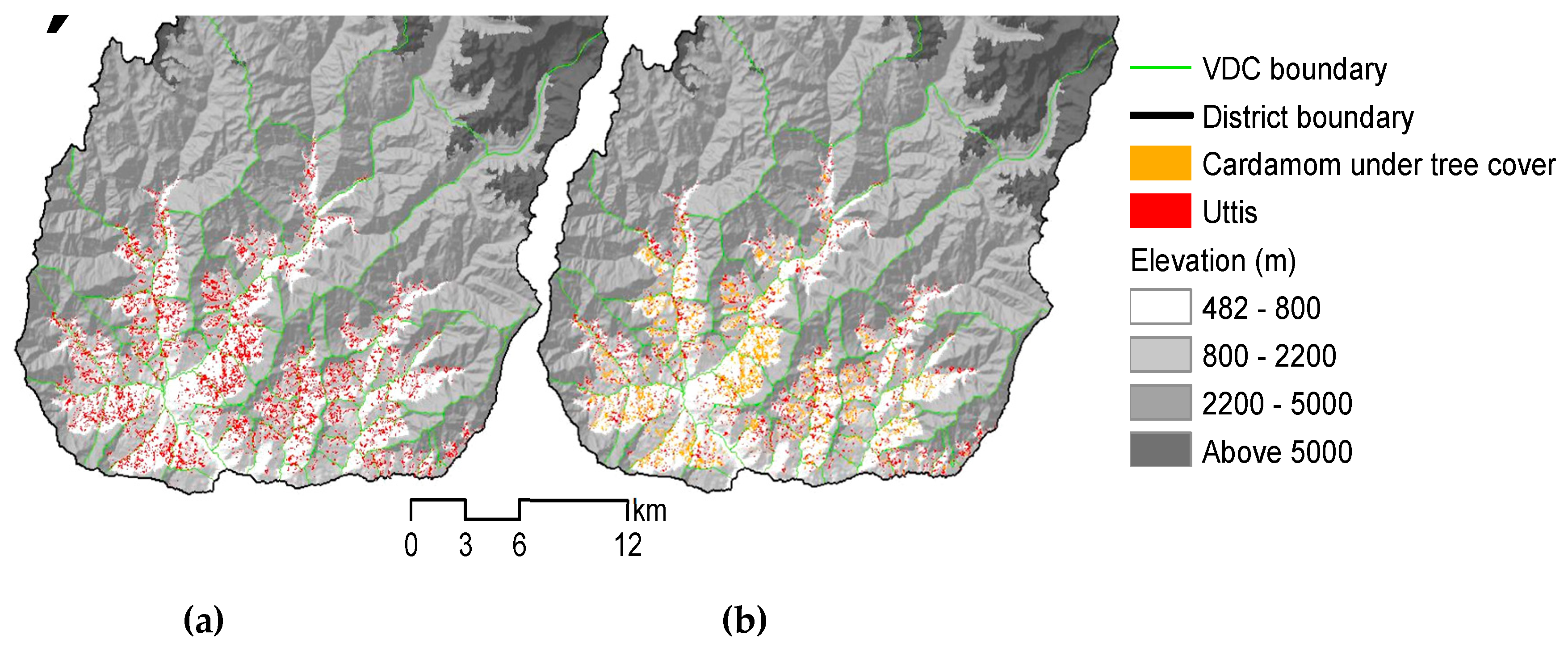
3.2. Uttis (Alnus nepalensis) Cover Mapping and Delineation of Accurate Large Cardamom Map
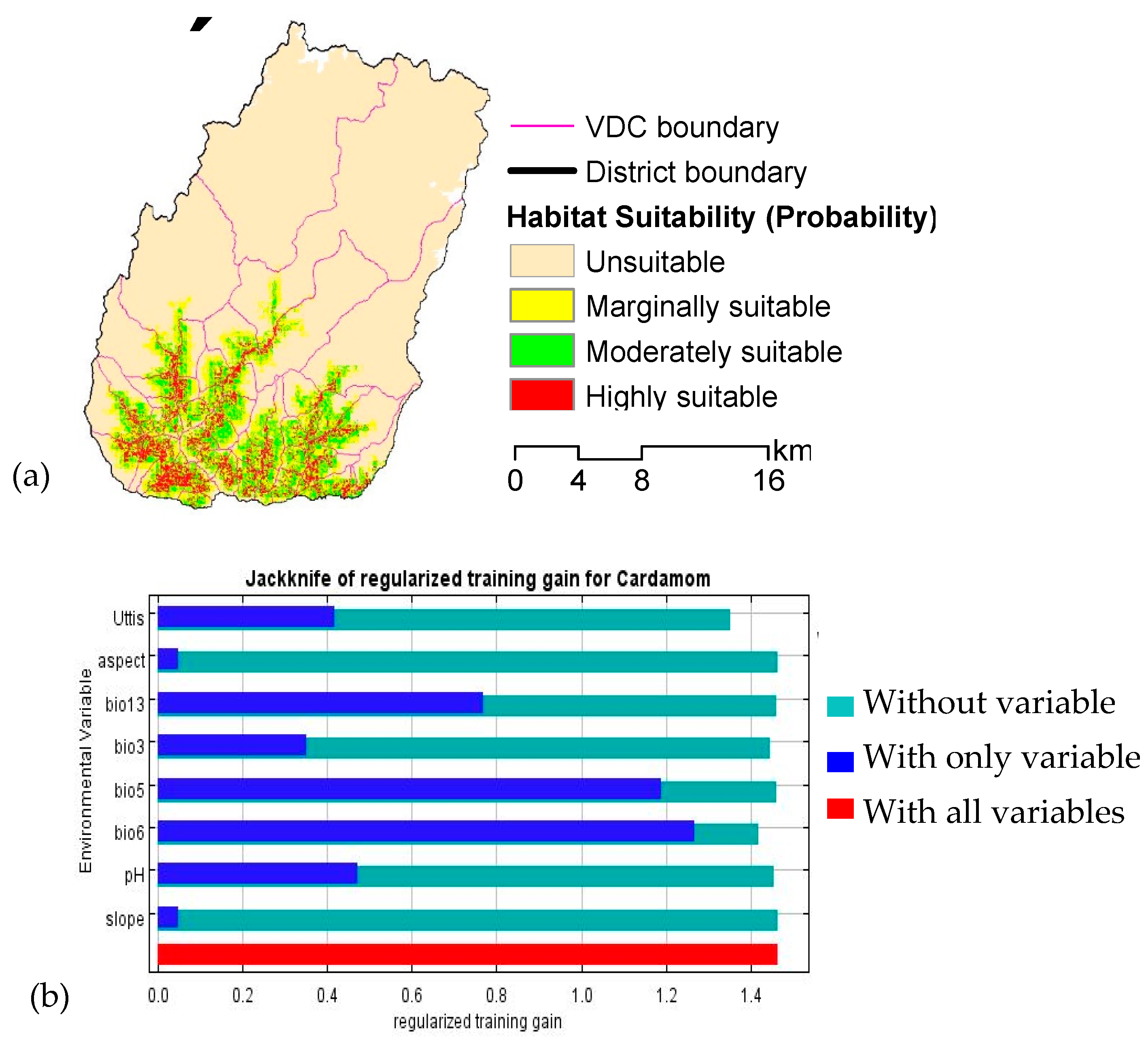
3.3. Current Suitable Habitat
3.4. Current Cardamom Cultivation and Habitat Suitability Analysis
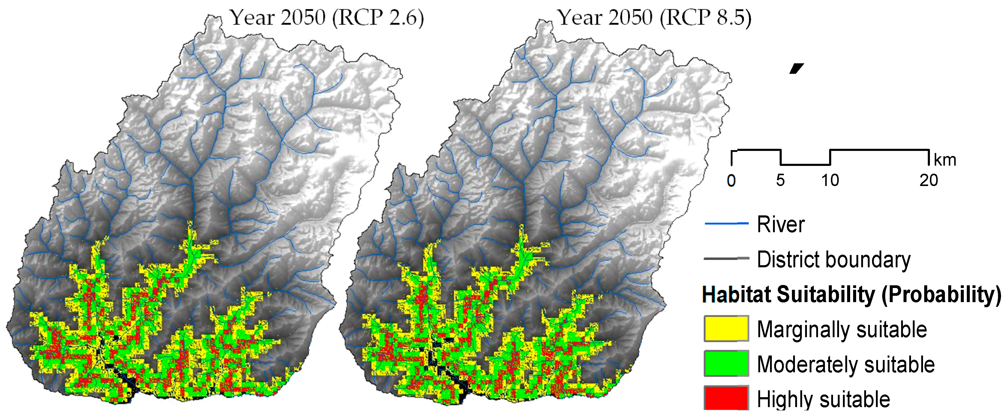
3.5. Suitable Habitat under Climate Change Scenerio
3.6. Projected Changes in the Suitable Habitat Area
4. Conclusions
Supplementary Materials
Author Contributions
Acknowledgments
Conflicts of Interest
References
- Sharma, E.; Sharma, R.; Singh, K.K.; Sharma, G. A Boon for Mountain Populations: Large Cardamom Farming in the Sikkim Himalaya. Mt. Res. Dev. 2000, 20, 108–111. [Google Scholar] [CrossRef]
- Sharma, G.; Joshi, S.R.; Gurung, M.B.; Chilwal, H.C. Package of Practices for Promoting Climate Resilient Cardamom Value Chains in Nepal. In Training Manual; International Centre for Integrated Mountain Development (ICIMOD): Kathmandu, Nepal, 2017. [Google Scholar]
- Vijayan, A.K. Climate change and its impact of an productivity of large cardamom (Amomum subutatum Roxburgh). In Proceedings of the Stakeholders Consultation Workshop on Large Cardamom Development in Nepal, Pakhribas, Nepal, 20 April 2015; pp. 16–27. [Google Scholar]
- Lenoir, J.; Gegout, J.C.; Marquet, P.A.; de Ruffray, P.; Brisse, H. A Significant Upward Shift in Plant Species Optimum Elevation during the 20th Century. Science 2008, 320, 1768–1771. [Google Scholar] [CrossRef]
- Bertrand, R.; Lenoir, J.; Piedallu, C.; Riofrío-Dillon, G.; de Ruffray, P.; Vidal, C.; Pierrat, J.C.; Gégout, J.C. Changes in plant community composition lag behind climate warming in lowland forests. Nature 2011, 479, 517–520. [Google Scholar] [CrossRef]
- Rijal, S.P. Impact of climate change on large cardamom-based livelihoods in Panchthar District, Nepal. Third Pole J. Geogr. Educ. 2013, 13, 33–38. [Google Scholar] [CrossRef]
- Justice, C.O.; Becker-Reshef, I. Developing a Strategy for Global Agricultural Monitoring in the Framework of Group on Earth Observations (GEO) Workshop Report; FAO: Rome, Italy, 2007. [Google Scholar]
- Soares, J.; Williams, M.; Jarvis, I.; Bingfang, W.; Leo, O.; Fabre, P.; Huynh, F.; Kosuth, P.; Lepoutre, D.; Parilar, J.S.; et al. Strengthening Global Agricultural Monitoring—Improving Sustainable Data for Worldwide Food Security & Commodity Market Transparency. 2011, pp. 1–16. Available online: http://www.earthobservations.org/documents/cop/ag_gams/201106_g20_global_agricultural_monitoring_initiative.pdf (accessed on 23 July 2019).
- Asner, G.P.; Knapp, D.E.; Kennedy-Bowdoin, T.; Jones, M.O.; Martin, R.E.; Boardman, J.; Hughes, R.F. Invasive species detection in Hawaiian rainforests using airborne imaging spectroscopy and LiDAR. Remote Sens. Environ. 2008, 112, 1942–1955. [Google Scholar] [CrossRef]
- Tuanmu, M.N.; Viña, A.; Bearer, S.; Xu, W.; Ouyang, Z.; Zhang, H.; Liu, J. Mapping understory vegetation using phenological characteristics derived from remotely sensed data. Remote Sens. Environ. 2010, 114, 1833–1844. [Google Scholar] [CrossRef]
- Hall, R.J.; Peddle, D.R.; Klita, D.L. Mapping conifer understory within boreal mixedwoods from Landsat TM satellite imagery and forest inventory information. For. Chron. 2000, 76, 887–902. [Google Scholar] [CrossRef] [Green Version]
- Johnston, S.E.; Henry, M.C.; Gorchov, D.L. Using Advanced Land Imager (ALI) and Landsat Thematic Mapper (TM) for the Detection of the Invasive Shrub Lonicera maackii in Southwestern Ohio Forests. GIScience Remote Sens. 2012, 49, 450–462. [Google Scholar] [CrossRef]
- Resasco, J.; Hale, A.N.; Henry, M.C.; Gorchov, D.L. Detecting an invasive shrub in a deciduous forest understory using latefall Landsat sensor imagery. Int. J. Remote Sens. 2007, 28, 3739–3745. [Google Scholar] [CrossRef]
- Becker, R.H.; Zmijewski, K.A.; Crail, T. Seeing the forest for the invasives: Mapping buckthorn in the Oak Openings. Biol. Invasions 2013, 15, 315–326. [Google Scholar] [CrossRef]
- Leduc, M.B.; Knudby, A.J. Mapping wild leek through the forest canopy using a UAV. Remote Sens. 2018, 10, 70. [Google Scholar] [CrossRef]
- Korpela, I.S. Mapping of understory lichens with airborne discrete-return LiDAR data. Remote Sens. Environ. 2008, 112, 3891–3897. [Google Scholar] [CrossRef]
- Peckham, S.D.; Ahl, D.E.; Gower, S.T. Bryophyte cover estimation in a boreal black spruce forest using airborne lidar and multispectral sensors. Remote Sens. Environ. 2009, 113, 1127–1132. [Google Scholar] [CrossRef]
- Singh, K.K.; Davis, A.J.; Meentemeyer, R.K. Detecting understory plant invasion in urban forests using LiDAR. Int. J. Appl. Earth Obs. Geoinf. 2015, 38, 267–279. [Google Scholar] [CrossRef] [Green Version]
- Vierling, K.T.; Vierling, L.A.; Gould, W.A.; Martinuzzi, S.; Clawges, R.M. Lidar: Shedding new light on habitat characterization and modeling. Front. Ecol. Environ. 2008, 6, 90–98. [Google Scholar] [CrossRef]
- Wang, T.J.; Skidmore, A.K.; Toxopeus, A.G. Improved understorey bamboo cover mapping using a novel hybrid neural network and expert system. Int. J. Remote Sens. 2009, 30, 965–981. [Google Scholar] [CrossRef]
- Phillips, S.B.; Aneja, V.P.; Kang, D.; Arya, S.P. Modelling and analysis of the atmospheric nitrogen deposition in North Carolina. Int. J. Glob. Environ. Issues 2006, 6, 231–252. [Google Scholar] [CrossRef]
- Graham, C.H.; Ferrier, S.; Huettman, F.; Moritz, C.; Peterson, A.T. New developments in museum-based informatics and applications in biodiversity analysis. Trends Ecol. Evol. 2004, 19, 497–503. [Google Scholar] [CrossRef]
- Barik, S.K.; Adhikari, D. Predicting the geographical distribution of an invasive species (Chromolaena odorata L. (king) & H.E. Robins) in the Indian subcontinent under climate change scenarios. In Invasive Alien Plants: An Ecological Appraisal for the Indian Subcontinent; CABI: Wallingford, UK, 2011. [Google Scholar]
- Niphadkar, M.; Nagendra, H.; Tarantino, C.; Adamo, M.; Blonda, P. Comparing Pixel and Object-Based Approaches to Map an Understorey Invasive Shrub in Tropical Mixed Forests. Front. Plant Sci. 2017, 8, 1–18. [Google Scholar] [CrossRef]
- Blaschke, T. Object based image analysis for remote sensing. ISPRS J. Photogramm. Remote Sens. 2010, 65, 2–16. [Google Scholar] [CrossRef] [Green Version]
- Mialhe, F.; Gunnell, Y.; Ignacio, J.A.F.; Delbart, N.; Ogania, J.L.; Henry, S. Monitoring land-use change by combining participatory land-use maps with standard remote sensing techniques: Showcase from a remote forest catchment on Mindanao, Philippines. Int. J. Appl. Earth Obs. Geoinf. 2015, 36, 69–82. [Google Scholar] [CrossRef]
- Robiglio, V.; Mala, W.A. Integrating local and expert knowledge using participatory mapping and GIS to implement intergrated forest management options in Akok, Cameroon. For. Chron. 2005, 81, 392–397. [Google Scholar] [CrossRef]
- Lauer, M.; Aswani, S. Integrating indigenous ecological knowledge and multi-spectral image classification for marine habitat mapping in Oceania. Ocean Coast. Manag. 2008, 51, 495–504. [Google Scholar] [CrossRef]
- Elith, J.; Graham, C.H.; Anderson, R.P.; Dudı’k, M.; Ferrier, S.; Guisan, A.; Hijmans, R.J.; Huettmann, F.; Leathwick, J.R.; Lehmann, A.; et al. Novel methods improve prediction of species’ distributions from occurrence data. Ecography 2006, 29, 129–151. [Google Scholar] [CrossRef]
- Pearson, R.G.; Raxworthy, C.J.; Nakamura, M.; Townsend Peterson, A. Predicting species distributions from small numbers of occurrence records: A test case using cryptic geckos in Madagascar. J. Biogeogr. 2007, 34, 102–117. [Google Scholar] [CrossRef]
- Kumar, S.; Stohlgren, T.J. Maxent modeling for predicting suitable habitat for threatened and endangered tree Canacomyrica monticola in New Caledonia. J. Ecol. Nat. Environ. 2009, 1, 094–098. [Google Scholar]
- Shrestha, J.; Prasai, H.K.; Timilsina, K.P.; Shrestha, K.P.; Pokhrel, D.; Paudel, K.; Yadav, M. Large Cardamom in Nepal: Production Practice and Economics, Processing and Marketing; National Commercial Agriculture Research Program, Nepal Agriculture Research Council: Pakhribas, Dhankuta, Nepal, 2018. [Google Scholar]
- McCall, M.K.; Minang, P.A. Assessing Participatory GIS for Community-Based Natural Resource Management: Claiming Community Forests in Cameroon. Geogr. J. 2005, 171, 340–356. [Google Scholar] [CrossRef]
- Drusch, M.; Del Bello, U.; Carlier, S.; Colin, O.; Fernandez, V.; Gascon, F.; Hoersch, B.; Isola, C.; Laberinti, P.; Martimort, P.; et al. Sentinel-2: ESA’s Optical High-Resolution Mission for GMES Operational Services. Remote Sens. Environ. 2012, 120, 25–36. [Google Scholar] [CrossRef]
- Blaschke, T.; Lang, S.; Lorup, E.; Strobl, J.; Zeil, P. Object-Oriented Image Processing in an Integrated GIS/Remote Sensing Environment and Perspectives for Environmental Applications. Umweltinf. Plan. Polit. Öffentl.keit Environ. Inf. Plan. Polit. Public 2000, 2, 555–570. [Google Scholar]
- Hay, G.J.; Blaschke, T.; Marceau, D.J.; Bouchard, A. A comparison of three image-object methods for the multiscale analysis of landscape structure. ISPRS J. Photogramm. Remote Sens. 2003, 57, 327–345. [Google Scholar] [CrossRef]
- Belgiu, M.; Drǎguţ, L. Comparing supervised and unsupervised multiresolution segmentation approaches for extracting buildings from very high resolution imagery. ISPRS J. Photogramm. Remote Sens. 2014, 96, 67–75. [Google Scholar] [CrossRef] [Green Version]
- National Spice Crop Development Programme. Annual Report of National Spice Crop Development Programme; National Spice Crop Development Programme, Ministry of Agriculture Development, Government of Nepal: Khumaltar, Kathmandu, Nepal, 2009.
- Uddin, K.; Shrestha, H.L.; Murthy, M.S.R.; Bajracharya, B.; Shrestha, B.; Gilani, H.; Pradhan, S.; Dangol, B. Development of 2010 national land cover database for the Nepal. J. Environ. Manag. 2015, 148, 82–90. [Google Scholar] [CrossRef]
- Tadono, T.; Ishida, H.; Oda, F.; Naito, S.; Minakawa, K.; Iwamoto, H. Precise Global DEM Generation by ALOS PRISM. ISPRS Ann. Photogramm. Remote Sens. Spat. Inf. Sci. 2014, II–4, 71–76. [Google Scholar] [CrossRef]
- Micheal, H. Graham Confronting Multicollinearity in Ecological Multiple Regression. Ecology 2003, 84, 2809–2815. [Google Scholar]
- Yang, X.Q.; Kushwaha, S.P.S.; Saran, S.; Xu, J.; Roy, P.S. Maxent modeling for predicting the potential distribution of medicinal plant, Justicia adhatoda L. in Lesser Himalayan foothills. Ecol. Eng. 2013, 51, 83–87. [Google Scholar] [CrossRef]
- Naimi, B.; Hamm, N.A.S.; Groen, T.A.; Skidmore, A.K.; Toxopeus, A.G. Where is Positional Uncertainty a Problem for Species Distribution Modelling? Available online: https://onlinelibrary.wiley.com/doi/abs/10.1111/j.1600-0587.2013.00205.x (accessed on 11 July 2019).
- Maharjan, S. Estimation and Mapping Above Ground Woody Carbon Stocks Using Lidar Data And Digital Camera Imagery in The Hilly Forest of Gorkha, Nepal. Master’s Thesis, University of Twente, Enschede, The Netherlands, 2012. [Google Scholar]
- Karna, Y.K.; Hussin, Y.A.; Gilani, H.; Bronsveld, M.C.; Murthy, M.S.R.; Qamer, F.M.; Karky, B.S.; Bhattarai, T.; Aigong, X.; Baniya, C.B. Integration of WorldView-2 and airborne LiDAR data for tree species level carbon stock mapping in Kayar Khola watershed, Nepal. Int. J. Appl. Earth Obs. Geoinf. 2015, 38, 280–291. [Google Scholar] [CrossRef]
- Baniya, N.; Böehme, M.; Baniya, S. Physical land suitability assessment for the large cardamom amomum subulatum roxb. Cultivation in hills of Kathmandu valley. Chin. J. Popul. Resour. Environ. 2009, 7, 59–63. [Google Scholar] [CrossRef]
- ECDF. Alaichi Kheti and Prashodhan Hate Pustika; Environment Conservation and Development Forum: Taplejung, Mechi Zone, Nepal, 2008. [Google Scholar]
- Coro, G.; Magliozzi, C.; Ellenbroek, A.; Pagano, P. Improving data quality to build a robust distribution model for Architeuthis dux. Ecol. Model. 2015, 305, 29–39. [Google Scholar] [CrossRef]
- Aubry, K.B.; Raley, C.M.; McKelvey, K.S. The importance of data quality for generating reliable distribution models for rare, elusive, and cryptic species. PLoS ONE 2017, 12, 1–17. [Google Scholar] [CrossRef]
- Kumar, S.; Graham, J.; West, A.M.; Evangelista, P.H. Using district-level occurrences in MaxEnt for predicting the invasion potential of an exotic insect pest in India. Comput. Electron. Agric. 2014, 103, 55–62. [Google Scholar] [CrossRef]
- Stockwell, D.R.B.; Peterson, A.T. Effects of sample size on accuracy of species distribution models. Ecol. Model. 2002, 148, 1–13. [Google Scholar] [CrossRef]
- Dormann, C.F.; Elith, J.; Bacher, S.; Buchmann, C.; Carl, G.; Carré, G.; Marquéz, J.R.G.; Gruber, B.; Lafourcade, B.; Leitão, P.J.; et al. Collinearity: A review of methods to deal with it and a simulation study evaluating their performance. Ecography 2013, 36, 027–046. [Google Scholar] [CrossRef]
- Evangelista, P.H.; Kumar, S.; Stohlgren, T.J.; Jarnevich, C.S.; Crall, A.W.; Norman, J.B.; Barnett, D.T. Modelling invasion for a habitat generalist and a specialist plant species. Divers. Distrib. 2008, 14, 808–817. [Google Scholar] [CrossRef]
- Elith, J.; Graham, C.H.; Anderson, R.P.; Dudík, M.; Guisan, A.; Hijmans, R.J.; Huettmann, F.; Leathwick, J.R.; Lehmann, A.; Li, J.; et al. Novel Methods Improve Prediction of Species’ Distributions from OccurrenceData. Ecography. 2006, 29, 129–151. [Google Scholar] [CrossRef]
- Ortega-Huerta, M.A.; Peterson, A.T. Modeling ecological niches and predicting geographic distributions: A test of six presence-only methods. Rev. Mex. De Biodivers. 2008, 79, 205–216. [Google Scholar]
- Pearce, J.; Ferrier, S. An evaluation of alternative algorithms for fitting species distribution models using logistic regression. Ecol. Model. 2000, 128, 127–147. [Google Scholar] [CrossRef]
- Elith, J. Quantitative Methods for Modeling Species Habitat: Comparative Performance and An Application to Australian Plants; Springer: New York, NY, USA, 2000. [Google Scholar]
- Li, R.; Xu, M.; Wong, M.H.G.; Qiu, S.; Sheng, Q.; Li, X.; Song, Z. Climate change-induced decline in bamboo habitats and species diversity: Implications for giant panda conservation. Divers. Distrib. 2014, 21, 379–391. [Google Scholar] [CrossRef]
- Lamsal, P.; Kumar, L.; Aryal, A.; Atreya, K. Invasive alien plant species dynamics in the Himalayan region under climate change. Ambio 2018, 47, 697–710. [Google Scholar] [CrossRef]
- Maclean, I.M.D.; Wilson, R.J. Recent ecological responses to climate change support predictions of high extinction risk. Proc. Natl. Acad. Sci. USA 2011, 108, 12337–12342. [Google Scholar] [CrossRef] [Green Version]
- Ponce-Reyes, R.; Nicholson, E.; Baxter, P.W.J.; Fuller, R.A.; Possingham, H. Extinction risk in cloud forest fragments under climate change and habitat loss. Divers. Distrib. 2013, 19, 518–529. [Google Scholar] [CrossRef] [Green Version]
- DHM Observed Climate Trend Analysis in the Districts and Physiographic Zones of Nepal (1971–2014); Government of Nepal Ministry of Population and Environment Department of Hydrology and Meteorology: Kathmandu, Nepal, 2017.
- MoFE Climate Change Scenarios for Nepal for National Adaptation Plan (NAP); Ministry of Forests and Environment: Kathmandu, Nepal, 2019.
- Gudade, B.A.; Harsha, K.N.; Vijayan, A.K.; Chhetri, P.; Deka, T.N.; Babu, S.; Singh, R. Effect of soil application of Zn, Mn and Mg on growth and nutrient content of large cardamom, Amomum subulatum Roxb at Sikkim. Int. J. Farm Sci. 2015, 5, 51–55. [Google Scholar]


| Observed Vegetation Classes | Grand Total | User’s Accuracy | ||||||
|---|---|---|---|---|---|---|---|---|
| Agriculture | Conifer | Other Broadleaf | Shrubs | Uttis | ||||
| Mapped Vegetation Classes | Agriculture | 15 | 0 | 0 | 3 | 1 | 19 | 79 |
| Conifer | 0 | 16 | 2 | 0 | 1 | 19 | 84 | |
| Other Broadleaf | 0 | 2 | 12 | 0 | 2 | 16 | 75 | |
| Shrubs | 2 | 0 | 3 | 16 | 0 | 21 | 76 | |
| Uttis | 2 | 0 | 3 | 1 | 25 | 31 | 81 | |
| Grand Total: | 19 | 18 | 20 | 20 | 29 | 106 | ||
| Producer’s Accuracy: | 79 | 89 | 60 | 80 | 86 | |||
| Overall accuracy: 80% | ||||||||
| Current Cultivation (2016) | Current | RCP2.6 (2050) | RCP8.5 (2050) | |||||||||||
|---|---|---|---|---|---|---|---|---|---|---|---|---|---|---|
| Suitability | Marginal | Moderate | High | Total | Marginal | Moderate | High | Total | Marginal | Moderate | High | Total | ||
| Elevation Ranges (m) | 500–1000 | 726 | 2673 | 1415 | 483 | 4571 | 2700 | 667 | 102 | 3469 | 2300 | 513 | 107 | 2920 |
| 1000–2000 | 17,400 | 16,699 | 21,038 | 12,866 | 50,602 | 15,952 | 22,471 | 13,374 | 51,797 | 15,521 | 23,318 | 11,300 | 50,139 | |
| 2000–3000 | 4603 | 16,686 | 5325 | 331 | 22,342 | 11,626 | 1075 | 18 | 12,719 | 12,266 | 1051 | 20 | 13,336 | |
| Total | 22,729 | 36,058 | 27,778 | 13,679 | 77,515 | 30,278 | 24,213 | 13,494 | 67,985 | 30,087 | 24,882 | 11,426 | 66,395 | |
© 2019 by the authors. Licensee MDPI, Basel, Switzerland. This article is an open access article distributed under the terms and conditions of the Creative Commons Attribution (CC BY) license (http://creativecommons.org/licenses/by/4.0/).
Share and Cite
Maharjan, S.; Qamer, F.M.; Matin, M.; Joshi, G.; Bhuchar, S. Integrating Modelling and Expert Knowledge for Evaluating Current and Future Scenario of Large Cardamom Crop in Eastern Nepal. Agronomy 2019, 9, 481. https://doi.org/10.3390/agronomy9090481
Maharjan S, Qamer FM, Matin M, Joshi G, Bhuchar S. Integrating Modelling and Expert Knowledge for Evaluating Current and Future Scenario of Large Cardamom Crop in Eastern Nepal. Agronomy. 2019; 9(9):481. https://doi.org/10.3390/agronomy9090481
Chicago/Turabian StyleMaharjan, Sajana, Faisal Mueen Qamer, Mir Matin, Govinda Joshi, and Sanjeev Bhuchar. 2019. "Integrating Modelling and Expert Knowledge for Evaluating Current and Future Scenario of Large Cardamom Crop in Eastern Nepal" Agronomy 9, no. 9: 481. https://doi.org/10.3390/agronomy9090481