Mapping an Agricultural Field Experiment by Electromagnetic Induction and Ground Penetrating Radar to Improve Soil Water Content Estimation


Abstract
1. Introduction
2. Materials and Methods
2.1. Study Area
2.2. Soil Water Content
2.3. Geophysical Investigation
2.4. Data Analysis
2.4.1. Pre-Processing of Geophysical Data
2.4.2. Geostatistical Analysis
2.4.3. Comparison between the Maps
3. Results
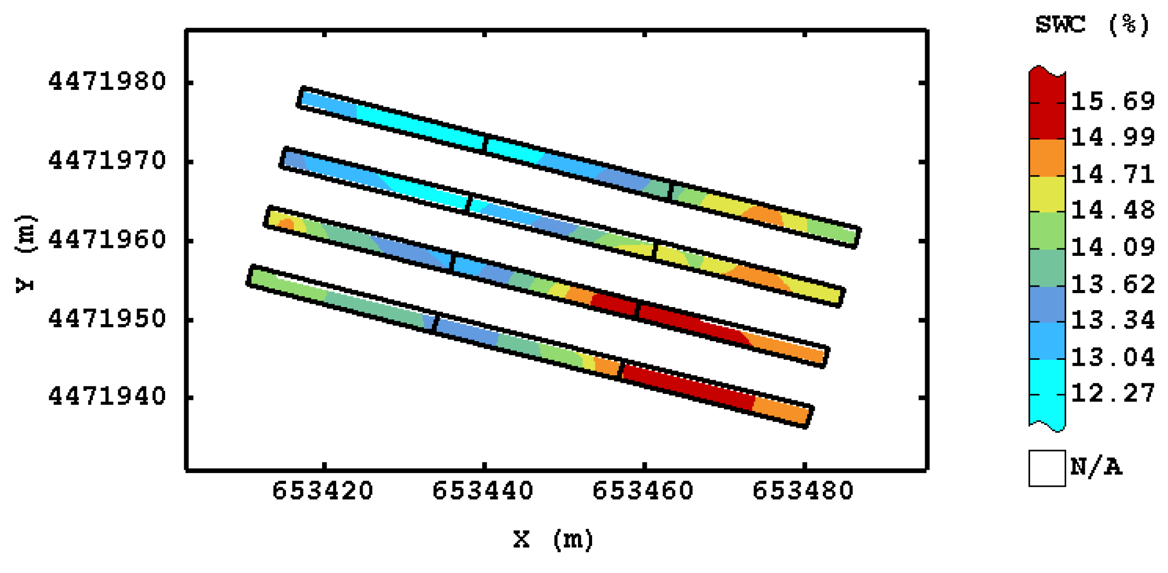
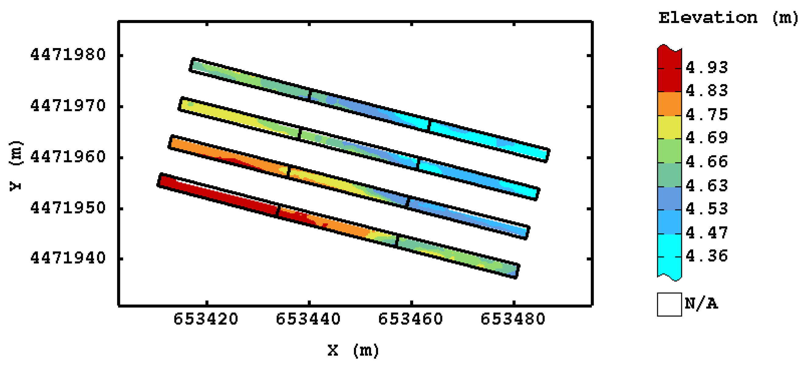
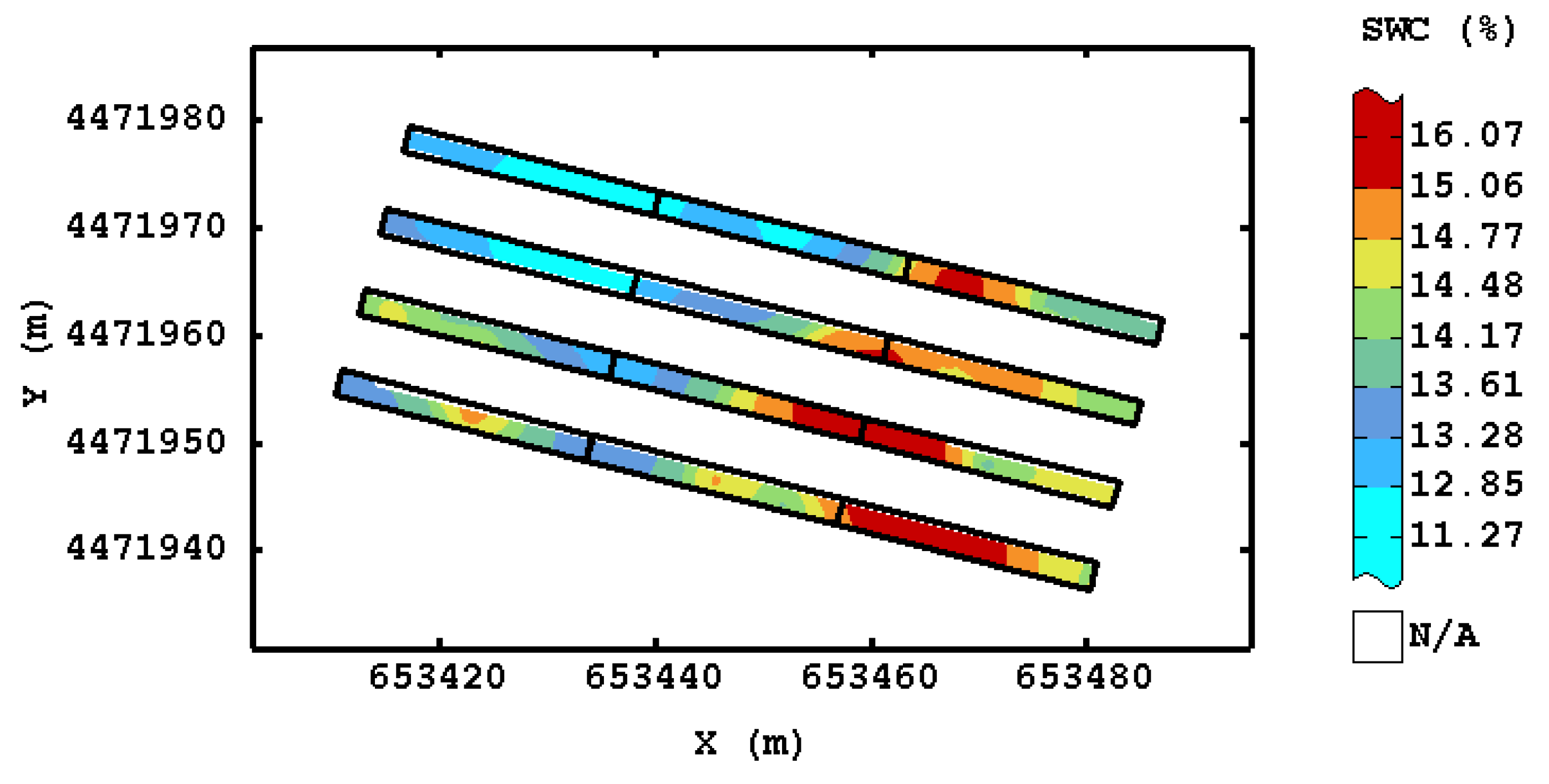
3.1. SWC and Eelevation Map
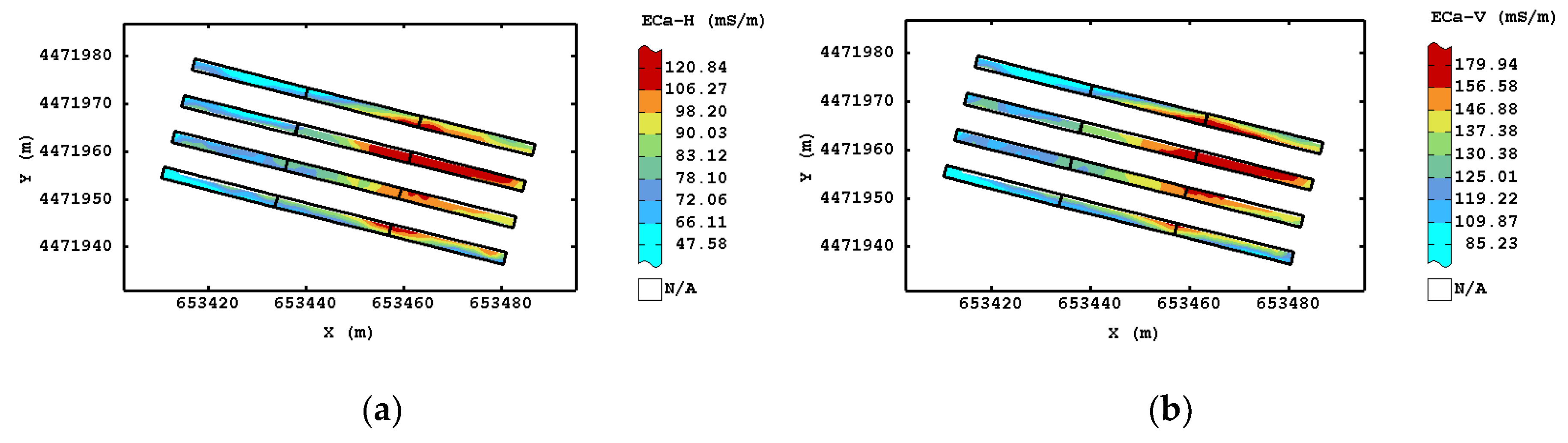
3.2. ECa Maps
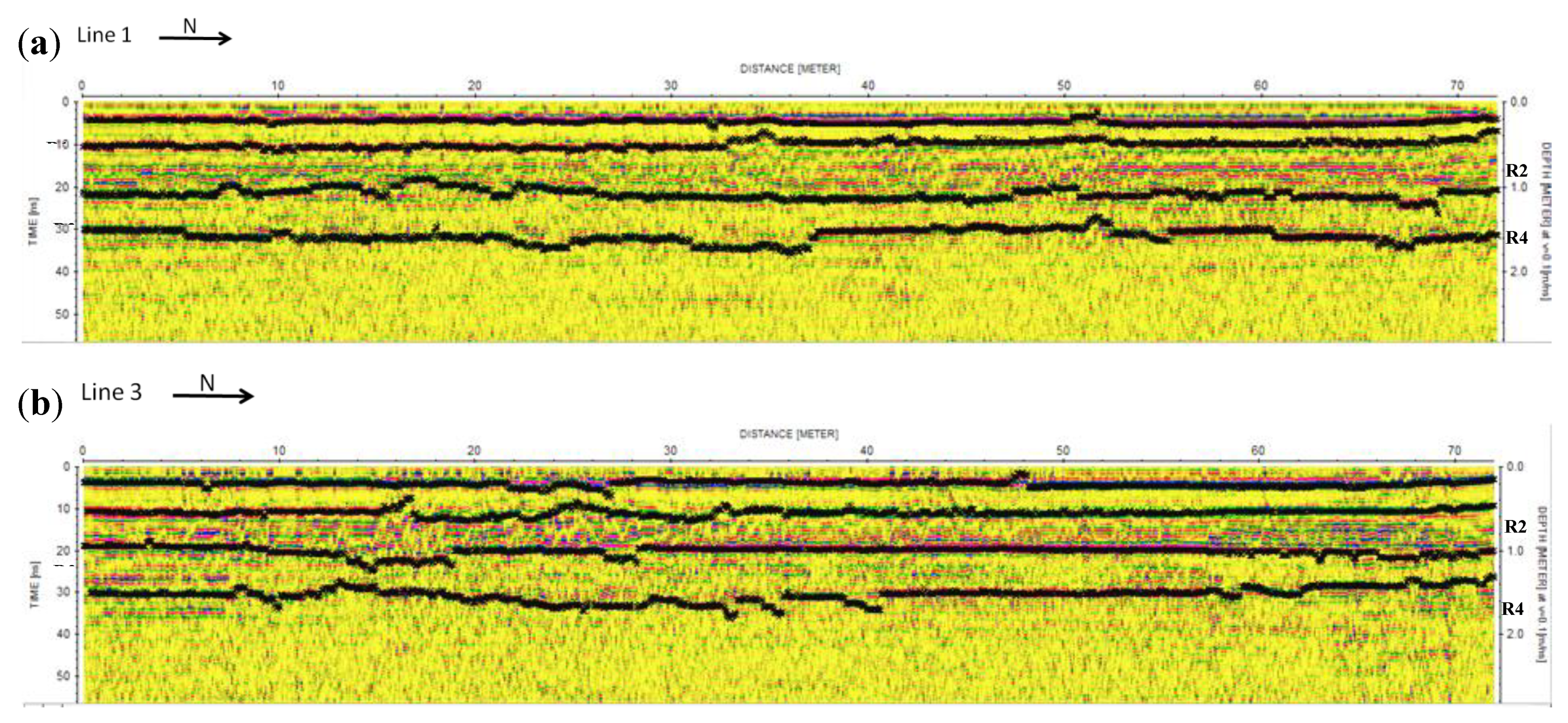
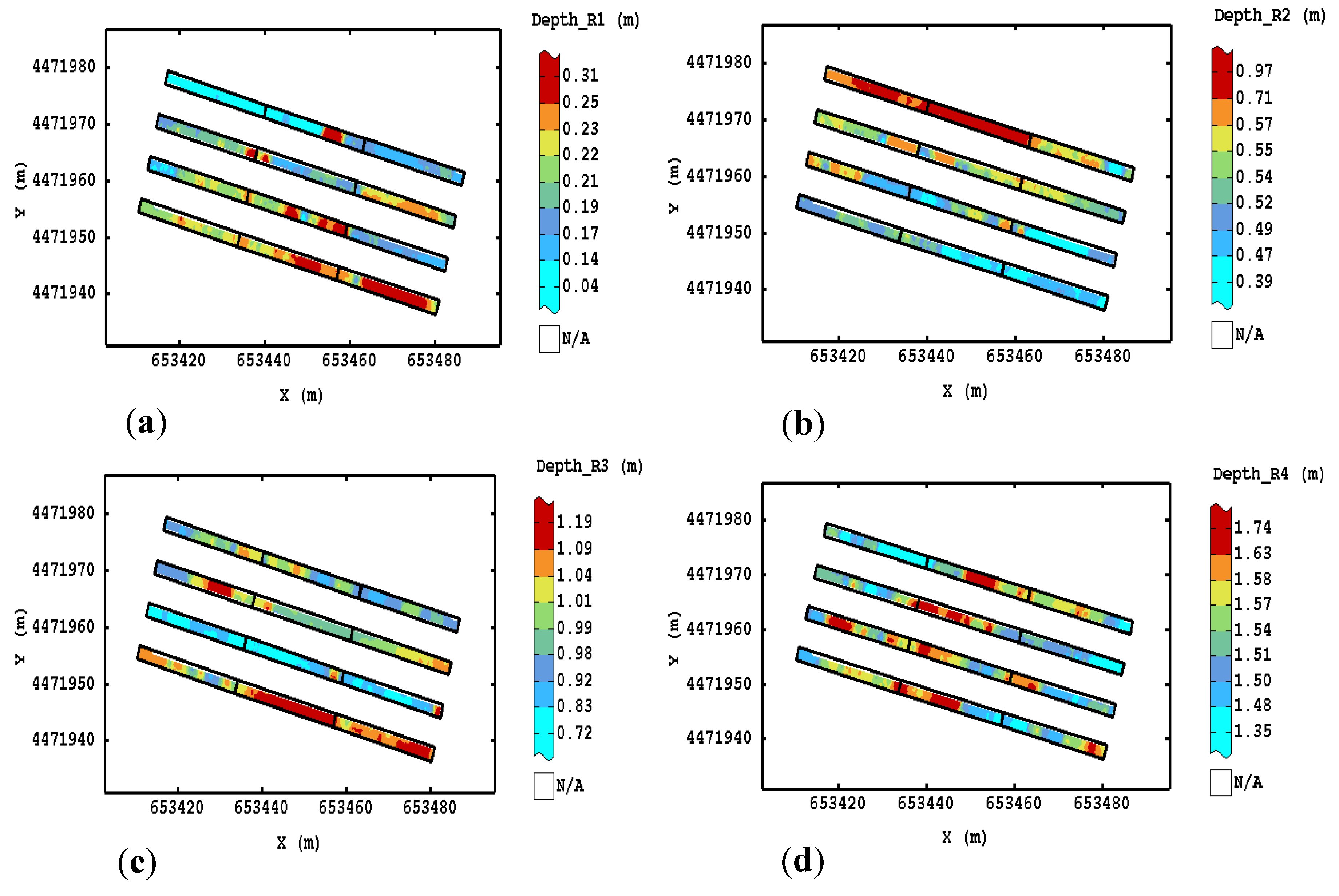
3.3. Ground Penetrating Radar Results
3.3.1. Radargrams Interpretation
3.3.2. GPR Maps
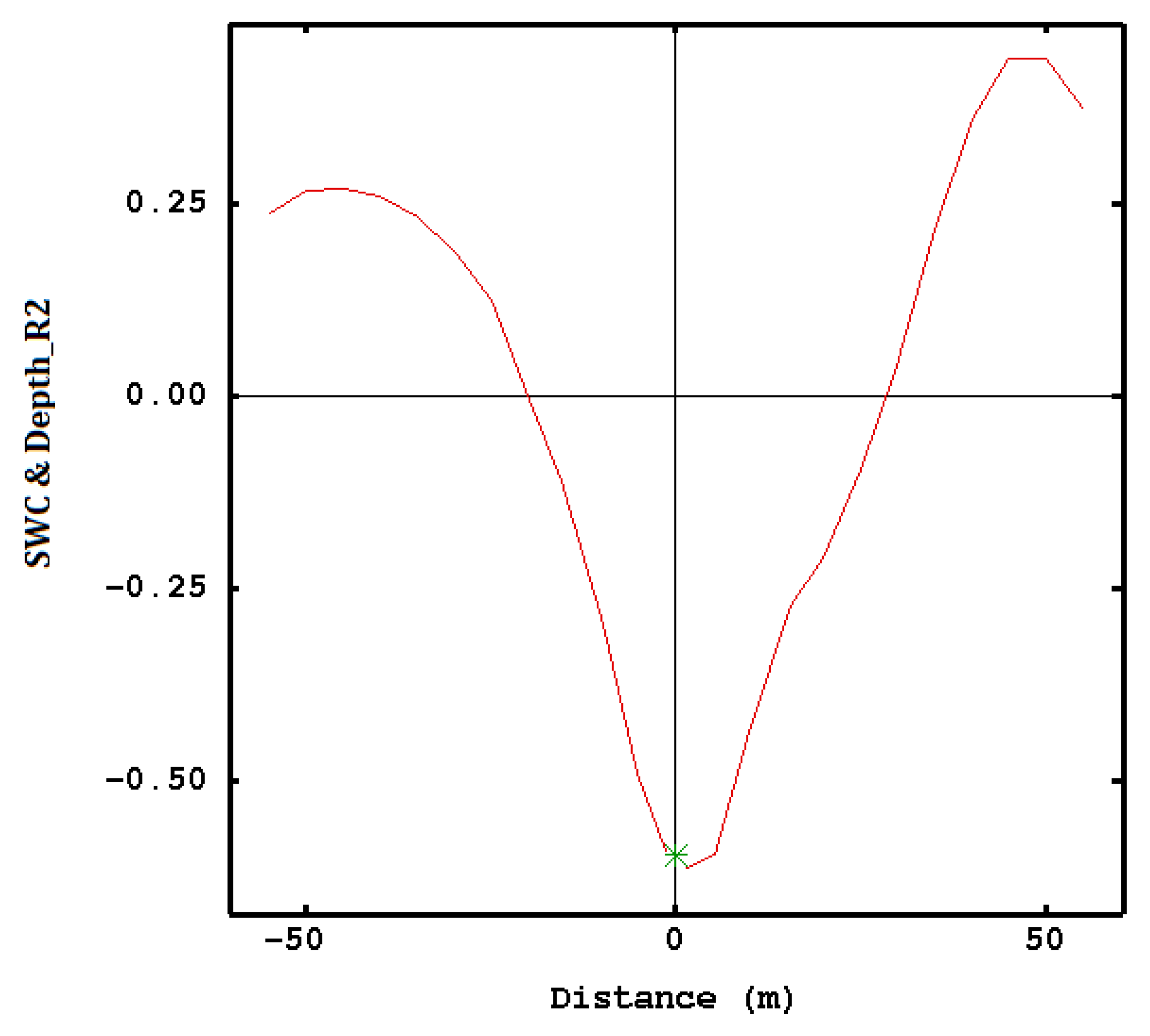
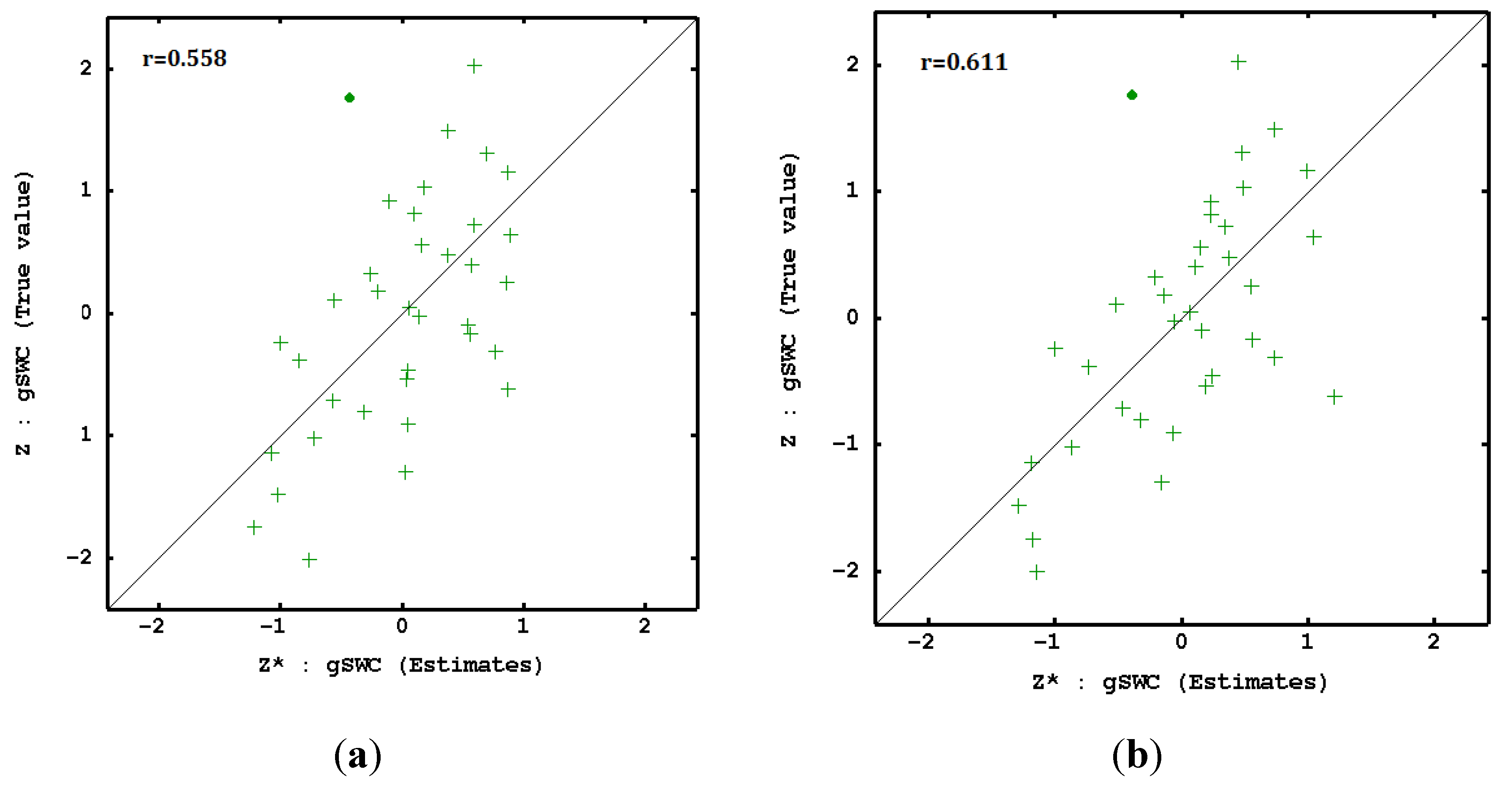
3.4. Spatial Prediction of SWC with Geophysical Parameters
4. Discussion
4.1. SWC and ECa Maps
4.2. Ground Penetrating Radar
4.3. Spatial Prediction of SWC with Geophysical Parameters
5. Conclusions
Author Contributions
Funding
Acknowledgments
Conflicts of Interest
References
- Montemurro, F.; Persiani, A.; Diacono, M. Environmental sustainability assessment of horticultural systems: A multi-criteria evaluation approach applied in a case study in Mediterranean conditions. Agronomy 2018, 8, 98. [Google Scholar] [CrossRef]
- Diacono, M.; Persiani, A.; Fiore, A.; Montemurro, F.; Canali, S. Agro-ecology for adaptation of horticultural systems to climate change: Agronomic and energetic performance evaluation. Agronomy 2017, 7, 35. [Google Scholar] [CrossRef]
- Vereecken, H.; Huisman, J.A.; Bogena, H.; Vanderborght, J.; Vrugt, J.A.; Hopmans, J.W. On the value of soil moisture measurements in vadose zone hydrology: A review. Water Resour. Res. 2008, 44, W00D06. [Google Scholar] [CrossRef]
- De Benedetto, D.; Montemurro, F.; Diacono, M. Impacts of agro-ecological practices on soil losses and cash crop yield. Agriculture 2017, 7, 103. [Google Scholar] [CrossRef]
- Rubin, Y. Soil Water Monitoring Using Geophysical Techniques: Development and Applications in Agriculture and Water Resources Management; Technical Completion Reports; University of California: Berkeley, CA, USA, 2003. [Google Scholar]
- Yoder, R.E.; Freeland, R.S.; Ammons, J.T.; Leonard, L.L. Mapping agricultural fields with GPR and EMI to identify offsite movement of agrochemicals. J. Appl. Geophys. 2001, 47, 251–259. [Google Scholar] [CrossRef]
- Algeo, J.; Slater, L.; Binley, A.; van Dam, R.L.; Watts, C. A comparison of ground-penetrating radar early-time signal approaches for mapping changes in shallow soil water content. Vadose Zone J. 2018, 17, 1. [Google Scholar] [CrossRef]
- Viscarra Rossel, R.A.; Adamchuk, V.I.; Sudduth, K.A.; McKenzie, N.J.; Lobsey, C. Proximal soil sensing: An effective approach for soil measurements in space and time. Adv. Agron. 2011, 113, 243–291. [Google Scholar] [CrossRef]
- Corwin, D.L.; Lesch, S.M. Application of soil electrical conductivity to precision agriculture: Theory, principles, and guidelines. Agron. J. 2003, 95, 455–471. [Google Scholar] [CrossRef]
- Reedy, R.C.; Scanlon, B.R. Soil water content monitoring using electromagnetic induction. J. Geotech. Geoenviron. Eng. 2003, 129, 1–12. [Google Scholar] [CrossRef]
- Brevik, E.C.; Fenton, T.E.; Lazari, A. Soil electrical conductivity as a function of soil water content and implications for soil mapping. Precis. Agric. 2006, 7, 393–404. [Google Scholar] [CrossRef]
- De Benedetto, D.; Castrignanò, A.; Diacono, M.; Rinaldi, M.; Ruggieri, S.; Tamborrino, R. Field partition by proximal and remote sensing data fusion. Biosyst. Eng. 2013, 114, 372–383. [Google Scholar] [CrossRef]
- Lunt, I.A.; Hubbard, S.S.; Rubin, U. Soil moisture estimation using ground penetrating radar reflection data. J. Hydrol. 2005, 307, 254–269. [Google Scholar] [CrossRef]
- Galagedara, L.W.; Parkin, G.W.; Redman, J.D.; von Bertoldi, P.; Endres, A.L. Field studies of the GPR ground wave method for estimating soil water content during irrigation and drainage. J. Hydrol. 2005, 301, 182–197. [Google Scholar] [CrossRef]
- Liu, X.; Chen, J.; Cui, X.; Liu, Q.; Cao, X.; Chen, X. Measurement of soil water content using ground-penetrating radar: A review of current methods. Int. J. Digit. Earth 2019, 12, 95–118. [Google Scholar] [CrossRef]
- Daniels, D.J. Ground Penetrating Radar, 2nd ed.; The Institution of Engineering and Technology: London, UK, 2004. [Google Scholar]
- Grote, K.; Anger, C.; Kelly, B.; Hubbard, S.; Rubin, Y. Characterization of soil water content variability and soil texture using GPR groundwave techniques. J. Environ. Eng. Geophys. 2010, 15, 93–110. [Google Scholar] [CrossRef]
- Hubbard, S.; Grote, K.; Rubin, Y. Mapping the volumetric soil water content of a California vineyard using high-frequency GPR ground wave data. Lead. Edge 2002, 25, 552–559. [Google Scholar] [CrossRef]
- Knight, R.; Tercier, P.; Jol, H. The role of ground-penetrating radar and geostatistics in reservoir description. Lead. Edge 1997, 16, 1576–1582. [Google Scholar] [CrossRef]
- De Benedetto, D.; Castrignanò, A.; Sollitto, D.; Modugno, F.; Buttafuoco, G.; Lo Papa, G. Integrating geophysical and geostatistical techniques to map the spatial variation of clay. Geoderma 2012, 171–172, 53–63. [Google Scholar] [CrossRef]
- Diacono, M.; Fiore, A.; Farina, R.; Canali, S.; Di Bene, C.; Testani, E.; Montemurro, F. Combined agro-ecological strategies for adaptation of organic horticultural systems to climate change in Mediterranean environment. Ital. J. Agron. 2016, 11, 730–785. [Google Scholar] [CrossRef]
- Soil Survey Staff USA. Soil Taxonomy: A Basic System of Soil Classification for Making and Interpreting Soil Surveys, 2nd ed.; Agriculture Handbook No. 436; Government Printing Office: Washington, DC, USA, 1999.
- UNESCO-FAO. Etude Écologique de la Zone Méditerranéenne. Carte Bioclimatique de la Zone Méditerranéenne. [Ecological Study of the Mediterranean Area: Bioclimatic Map of the Mediterranean Sea]. Paris-Rome. 1963. Available online: http://unesdoc.unesco.org/ images/0013/001372/137255fo.pdf (accessed on 3 January 2019).
- Ventrella, D.; Mohanty, B.P.; Simunek, J.; Losavio, N.; van Genuchten, M.T. Water and chloride transport in a fine-textured soil: Field experiments and modelling. Soil Sci. 2000, 165, 624–631. [Google Scholar] [CrossRef]
- Topp, G.C.; Davis, J.L.; Annan, A.P. Electromagnetic determination of soil water content: Measurements in coaxial transmission lines. Water Resour. Res. 1980, 16, 574–582. [Google Scholar] [CrossRef]
- De Benedetto, D.; Castrignanò, A.; Sollitto, D.; Modugno, F. Spatial relationship between clay content and geophysical data. Clay Miner. 2010, 45, 197–207. [Google Scholar] [CrossRef]
- De Benedetto, D.; Quarto, R.; Castrignanò, A.; Palumbo, D.A. Impact of data processing and antenna frequency on spatial structure modelling of GPR data. Sensors 2015, 15, 16430–16447. [Google Scholar] [CrossRef] [PubMed]
- Sandmeier Scientific Software. Reflexw, v.6.1.1, program for processing and interpretation of reflection and transmission data. User’s Manual Online Version, Karlruhe, Germany, 2012. [Google Scholar]
- Journel, A.; Huijbregts, C. Mining Geostatistics; Academic Press: London, UK, 1978. [Google Scholar]
- Cressie, N.A.C. Statistics for Spatial Data; Wiley & Sons: New York, NY, USA, 1991. [Google Scholar]
- Goovaerts, P. Geostatistics for Natural Resources Evaluation; Applied Geostatistics Series; Oxford University Press: Oxford, UK, 1997. [Google Scholar]
- SAS Institute Inc. 2013 SAS/STAT Software Release 9.3; SAS Institute Inc.: Cary, NC, USA, 2013. [Google Scholar]
- Rivoirard, J. Which models for collocated cokriging? J. Math. Geol. 2001, 33, 117–131. [Google Scholar] [CrossRef]
- Geovariances. Isatis Technical Ref.; ver. 2013.1; Geovariances & Ecole Des Mines De Paris: Avon CEDEX, France, 2015. [Google Scholar]
- Campbell, J. Introduction to Remote Sensing, 3rd ed.; The Guilford Press: New York, NY, USA, 2002. [Google Scholar]
- Kravchenko, A.N.; Omonode, R.; Bollero, G.A.; Bullock, D.G. Quantitative mapping of soil drainage classes using topographical data and soil electrical conductivity. Soil Sci. Soc. Am. J. 2003, 66, 235–243. [Google Scholar] [CrossRef]
- De Caires, S.A.; Wuddivira, M.N.; Bekele, I. Assessing the temporal stability of spatial patterns of soil apparent electrical conductivity using geophysical methods. Int. Agrophysics 2014, 28, 423–433. [Google Scholar] [CrossRef]
- Wackernagel, H. Multivariate Geostatistics: An Introduction with Applications; Springer: Berlin, Germany, 2003. [Google Scholar]
- Warrick, A.W.; Nielsen, D.R. Spatial Variability of Soil Physical Properties in the Field; Academic Press: New York, NY, USA, 1980; pp. 319–344. [Google Scholar]
- De Benedetto, D.; Castrignanò, A.; Quarto, R. A geostatistical approach to estimate soil moisture as a function of geophysical data and soil attributes. Procedia Environ. Sci. 2013, 19, 436–445. [Google Scholar] [CrossRef]
- De Benedetto, D.; Montemurro, F.; Diacono, M. Repeated geophysical measurements in dry and wet soil conditions to describe soil water content variability. Sci. Agric. 2019, in press. [Google Scholar]
- Barca, E.; De Benedetto, D.; Stellacci, A.M. Contribution of EMI and GPR proximal sensing data in soil water content assessment by using linear mixed effects models and geostatistical approaches. Geoderma 2019, 343, 280–293. [Google Scholar] [CrossRef]
- Serrano, J.M.; Peça, J.O.; Marques da Silva, J.R.; Shaidian, S. Mapping soil and pasture variability with an electromagnetic induction sensor. Comput. Electron. Agric. 2010, 73, 7–16. [Google Scholar] [CrossRef]
- Appels, W.M.; Bogaart, P.W.; van der Zee, S. Influence of spatial variations of microtopography and infiltration on surface runoff and field scale hydrological connectivity. Adv. Water Resour. 2011, 34, 303–313. [Google Scholar] [CrossRef]
- Zhu, Q.; Lin, H.; Doolittle, J. Repeated electromagnetic induction surveys for determining subsurface hydrologic dynamics in an agricultural landscape. Soil Sci. Soc. Am. J. 2010, 74, 1750–1762. [Google Scholar] [CrossRef]
- Martini, E.; Werban, U.; Zacharias, S.; Pohle, M.; Dietrich, P.; Wollschläger, U. Repeated electromagnetic induction measurements for mapping soil moisture at the field scale: Validation with data from a wireless soil moisture monitoring network. Hydrol. Earth Syst. Sci. 2017, 21, 495–513. [Google Scholar] [CrossRef]
- Johnson, C.; Eskridge, K.; Corwin, D. Apparent soil electrical conductivity: Applications for designing and evaluating field-scale experiments. Comput. Electron. Agric. 2005, 46, 181–202. [Google Scholar] [CrossRef]
- King, J.; Dampney, P.; Lark, R.; Wheeler, H.; Bradley, R.; Mayr, T. Mapping potential crop management zones within fields: Use of yield-map series and pat-terns of soil physical properties identified by electromagnetic induction sensing. Precis. Agric. 2005, 6, 167–181. [Google Scholar] [CrossRef]
- Bronson, K.; Booker, J.; Officer, S.; Lascano, R.; Maas, S.; Searcy, S.; Booker, J. Apparent electrical conductivity, soil properties and spatial covariance in the U.S. southern high plains. Precis. Agric. 2005, 6, 297–311. [Google Scholar] [CrossRef]
- Corwin, D.L.; Plant, R.E. Applications of apparent soil electrical conductivity in precision agriculture. Comput. Electron. Agric. 2005, 46, 1–10. [Google Scholar] [CrossRef]
- Annan, A.P.; Cosway, S.W.; Redman, J.D. Water table detection with ground-penetrating radar. In Proceedings of the SEG 61st Annual Meeting, Houston, TX, USA, January 1991. [Google Scholar]
- Comite, D.; Galli, A.; Lauro, S.E.; Mattei, E.; Pettinelli, E. Analysis of GPR early-time signal features for the evaluation of soil permittivity through numerical and experimental surveys. IEEE J. Sel. Top. Appl. Earth Obs. Remote Sens. 2016, 9, 178–187. [Google Scholar] [CrossRef]
- Algeo, J.; Van Dam, R.L.; Slater, L. Early-time GPR: A method to monitor spatial variations in soil water content during irrigation in clay soils. Vadose Zone J. 2016, 15, 1–9. [Google Scholar] [CrossRef]
- Hendrickx, J.M.H.; Hong, S.-H.; Miller, T.; Borchers, B.; Reberghen, J.B. Soil effects on GPR detection of buried non-metallic mines. Ground penetrating radar in sediments. Geol. Soc. Lond. Special Publ. 2003, 211, 191–198. [Google Scholar] [CrossRef]
- Wang, P.; Hu, Z.; Zhao, Y.; Li, X. Experimental study of soil compaction effects on GPR signals. J. Appl. Geophys. 2016, 126, 128–137. [Google Scholar] [CrossRef]
- Cafarelli, B.; Castrignanò, A.; De Benedetto, D.; Palumbo, A.D.; Buttafuoco, G. A linear mixed effect (LME) model for soil water content estimation based on geophysical sensing: A comparison of an LME model and kriging with external drift. Environ. Earth Sci. 2015, 73, 1951–1960. [Google Scholar] [CrossRef]
- Taylor, J.A.; Short, M.; McBratney, A.B.; Wilson, J. Comparing the ability of multiple soil sensors to predict soil properties in a Scottish potato production system. In Proximal Soil Sensing: Progress in Soil Science; Viscarra Rossel, R.A., McBratney, A.B., Minasny, B., Eds.; Springer Science +Business Media, B.V.: Dordrecht, The Netherlands, 2010; Volume 1, pp. 387–396, Part 5. [Google Scholar]


| Horizon | Depth (m) | Particle Size Distribution | ||
|---|---|---|---|---|
| Clay (%) | Silt (%) | Sand (%) | ||
| Ap | 0–(0.30–0.50) | 58.8 | 35.8 | 5.50 |
| Abss | (0.30–0.50)–0.70 | 60.0 | 35.8 | 4.23 |
| Abssk | 0.70–1 | 60.2 | 36.4 | 3.51 |
| Bw | 1–1.70 | 67.7 | 30.8 | 1.53 |
| Btg | 1.70–2.10 | 77.2 | 22.0 | 0.84 |
© 2019 by the authors. Licensee MDPI, Basel, Switzerland. This article is an open access article distributed under the terms and conditions of the Creative Commons Attribution (CC BY) license (http://creativecommons.org/licenses/by/4.0/).
Share and Cite
De Benedetto, D.; Montemurro, F.; Diacono, M. Mapping an Agricultural Field Experiment by Electromagnetic Induction and Ground Penetrating Radar to Improve Soil Water Content Estimation. Agronomy 2019, 9, 638. https://doi.org/10.3390/agronomy9100638
De Benedetto D, Montemurro F, Diacono M. Mapping an Agricultural Field Experiment by Electromagnetic Induction and Ground Penetrating Radar to Improve Soil Water Content Estimation. Agronomy. 2019; 9(10):638. https://doi.org/10.3390/agronomy9100638
Chicago/Turabian StyleDe Benedetto, Daniela, Francesco Montemurro, and Mariangela Diacono. 2019. "Mapping an Agricultural Field Experiment by Electromagnetic Induction and Ground Penetrating Radar to Improve Soil Water Content Estimation" Agronomy 9, no. 10: 638. https://doi.org/10.3390/agronomy9100638
APA StyleDe Benedetto, D., Montemurro, F., & Diacono, M. (2019). Mapping an Agricultural Field Experiment by Electromagnetic Induction and Ground Penetrating Radar to Improve Soil Water Content Estimation. Agronomy, 9(10), 638. https://doi.org/10.3390/agronomy9100638