UAV-Based Multispectral Inversion of Integrated Cotton Growth

 , ,
, ,
Abstract
1. Introduction
2. Materials and Methods
2.1. Overview of the Test Area
2.1.1. Location and Climatic Conditions
2.1.2. Experimental Design and Layout
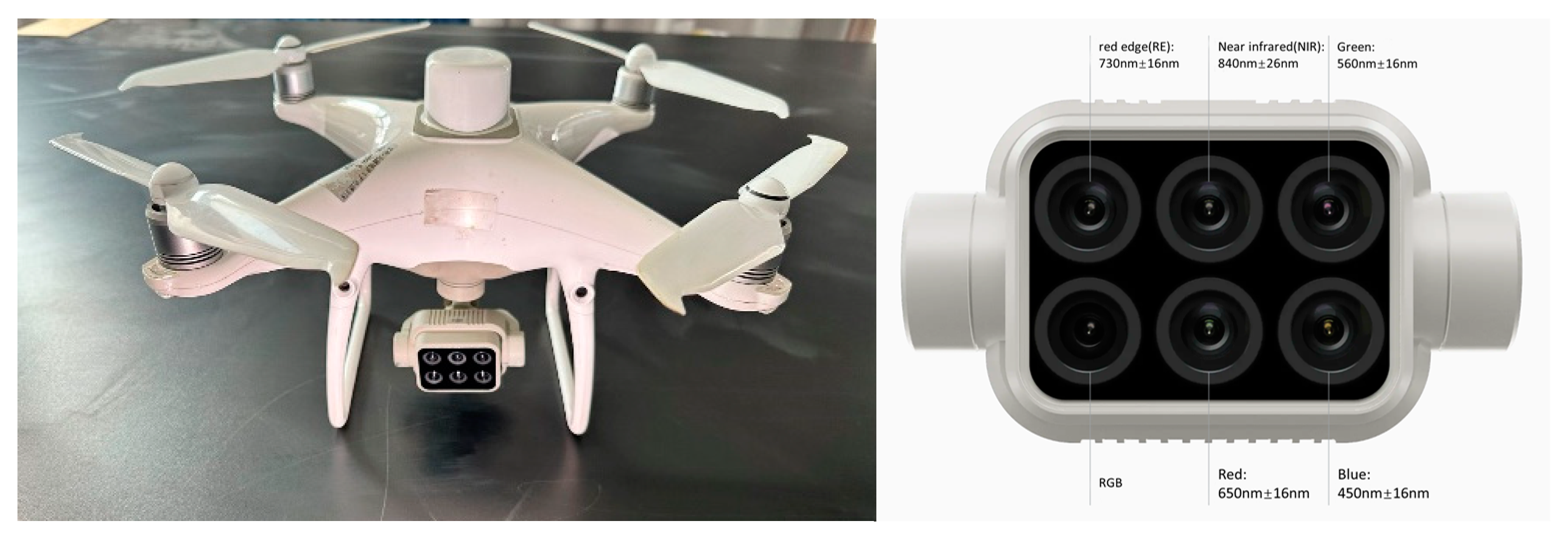
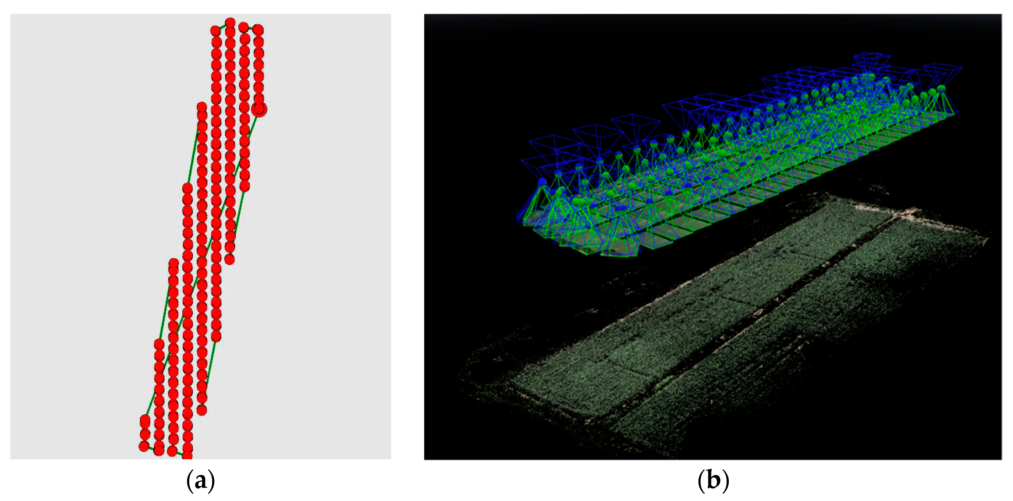
2.2. UAV Image Acquisition and Pre-Processing
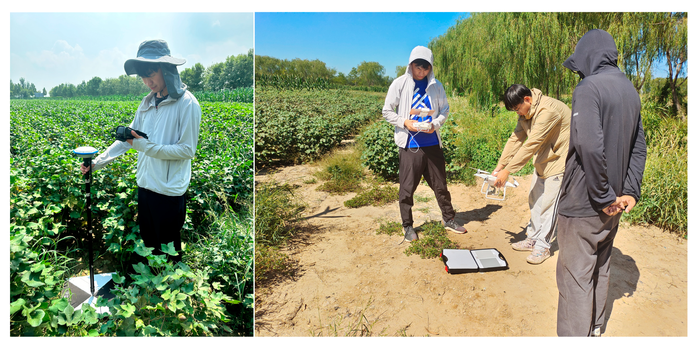
2.2.1. Ground Sampling
2.2.2. Cotton Canopy Image Acquisition
2.2.3. Image Pre-Processing
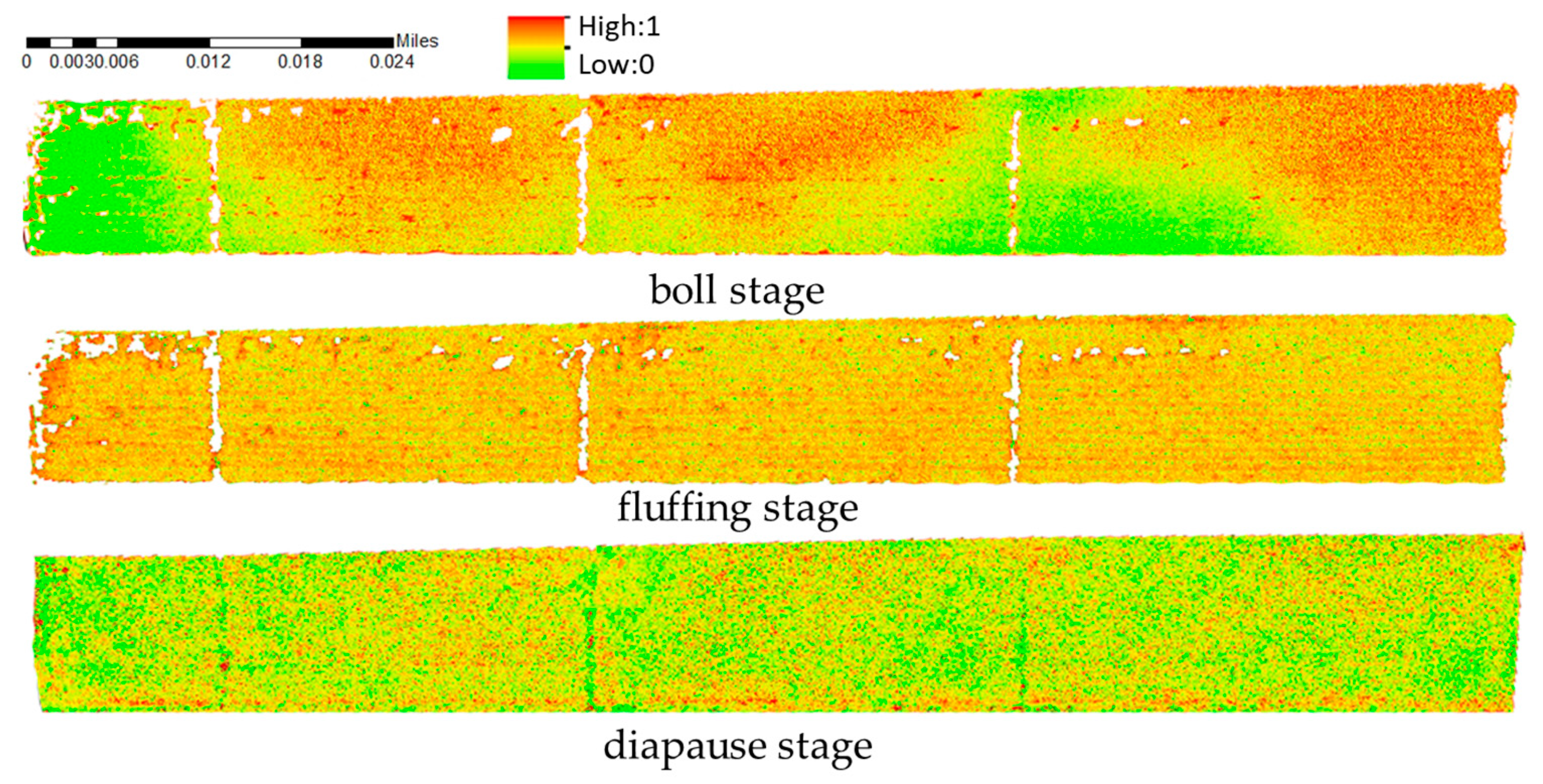
2.3. Construction of Integrated Cotton Growth Indicators
2.4. Cotton Integrated Growth Prediction Model Construction
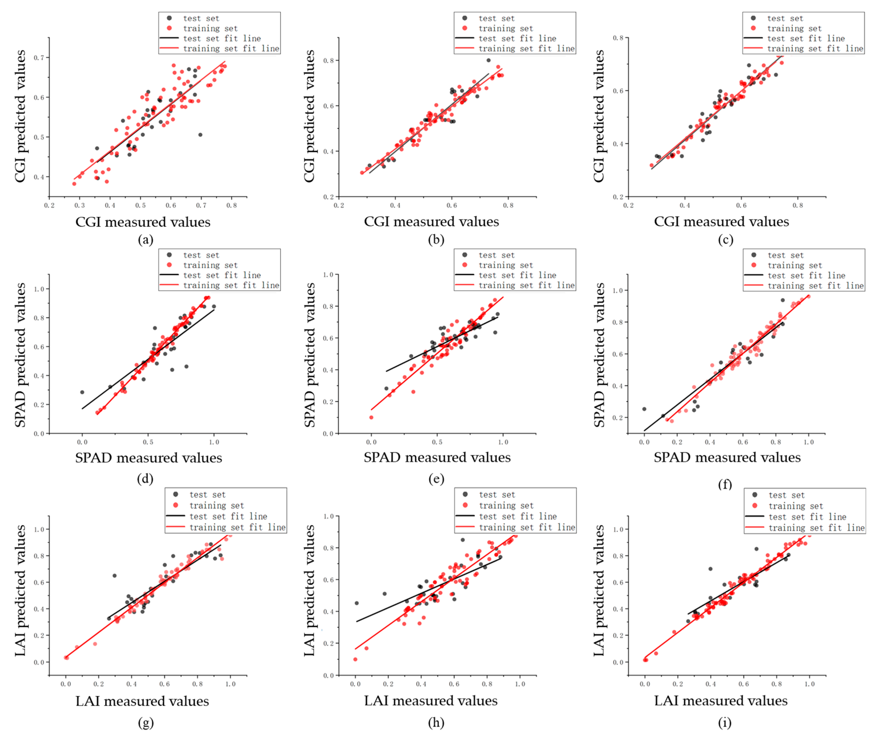
3. Results
3.1. Analysis of Ground-Truthing Data
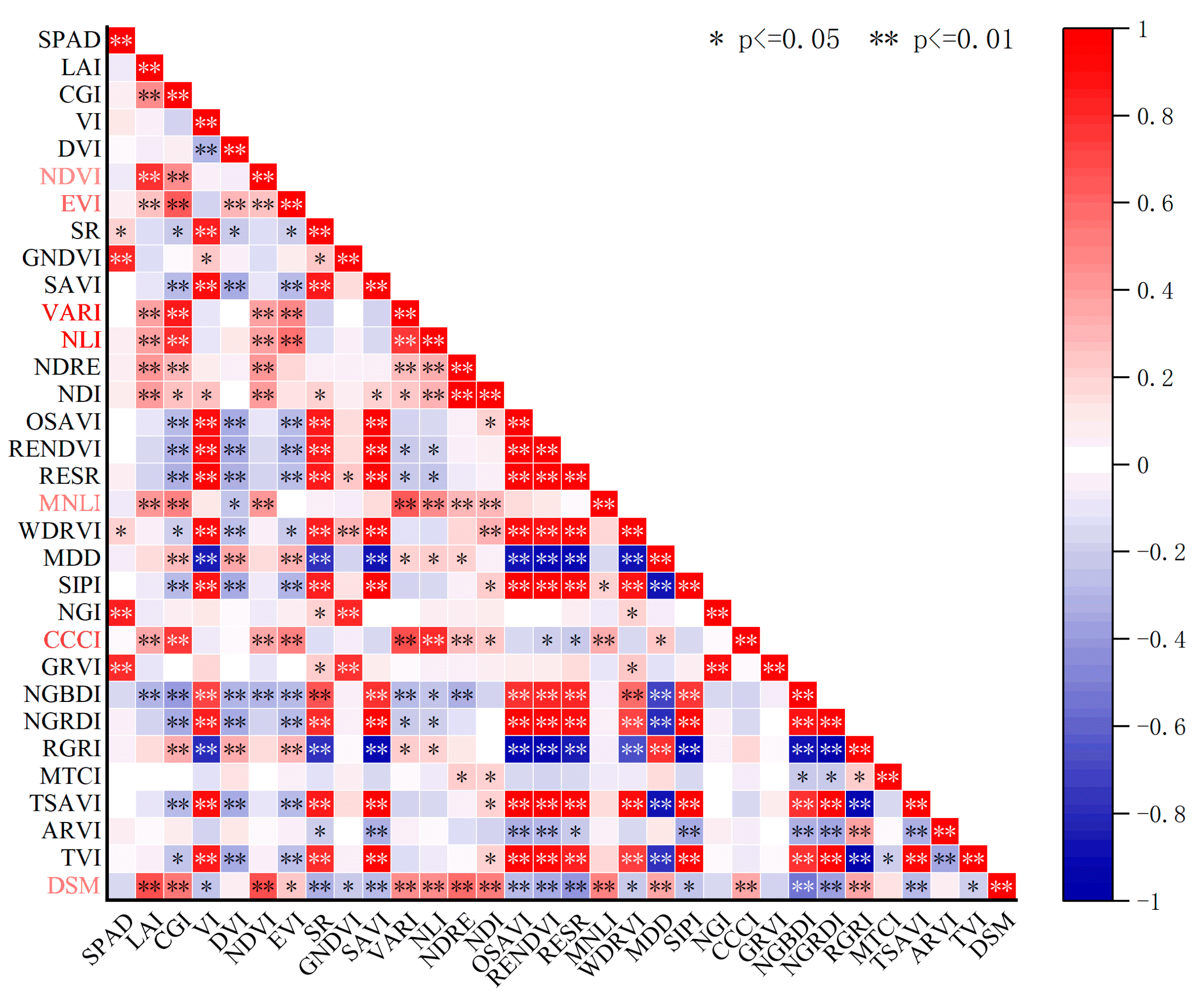
3.2. Correlation Analysis
3.3. Quantitative Evaluation of Radiation Correction
3.4. Modelling and Analysis
4. Discussion
5. Conclusions
Author Contributions
Funding
Data Availability Statement
Conflicts of Interest
References
- Yang, C.; Everitt, J.H.; Bradford, J.M.; Murden, D. Airborne Hyperspectral Imagery and Yield Monitor Data for Mapping Cotton Yield Variability. Precis. Agric. 2004, 5, 445–461. [Google Scholar] [CrossRef]
- Lan, Y.; Deng, X.; Zeng, G. Advances in diagnosis of crop diseases, pests and weeds by UAV remote sensing. Smart Agric. 2019, 1, 1–19. [Google Scholar]
- Tatsumi, K.; Yamashiki, Y.; Torres, M.A.C.; Taipe, C.L.R. Crop classification of upland fields using Random forest of time-series Landsat 7 ETM+ data. Comput. Electron. Agric. 2015, 115, 171–179. [Google Scholar] [CrossRef]
- Ebrahimi, M.; Khoshtaghaza, M.H.; Minaei, S.; Bahareh, J. Vision-based pest detection based on SVM classification method. Comput. Electron. Agric. 2017, 137, 52–58. [Google Scholar] [CrossRef]
- Cheng, M.; Penuelas, J.; McCabe, M.F.; Atzberger, C.; Jiao, X.; Wu, W.; Jin, X. Combining multi-indicators with machine-learning algorithms for maize yield early prediction at the county-level in China. Agric. For. Meteorol. 2022, 323, 109057. [Google Scholar] [CrossRef]
- Chen, P.; Xu, W.; Zhan, Y.; Wang, G.; Yang, W.; Lan, Y. Determining application volume of unmanned aerial spraying systems for cotton defoliation using remote sensing images. Comput. Electron. Agric. 2022, 196, 106912. [Google Scholar] [CrossRef]
- Lan, Y.; Chen, S. Current status and trends of plant protection UAV and its spraying technology in China. Int. J. Precis. Agric. Aviat. 2018, 1, 1–9. [Google Scholar] [CrossRef]
- Tahir, M.N.; Lan, Y.; Zhang, Y.; Wang, Y.; Nawaz, F.; Shah, M.A.A.; Gulzar, A.; Qureshi, W.S.; Naqvi, S.M.; Naqvi, S.Z.A. Real time estimation of leaf area index and groundnut yield using multispectral UAV. Int. J. Precis. Agric. Aviat. 2020, 3, 1–6. [Google Scholar]
- Pan, F.; Li, W.; Lan, Y.; Liu, X.; Miao, J.; Xiao, X.; Xu, H.; Lu, L.; Zhao, J. SPAD inversion of summer maize combined with multi-source remote sensing data. Int. J. Precis. Agric. Aviat. 2021, 4, 45–52. [Google Scholar] [CrossRef]
- Wang, Q.; Che, Y.; Chai, H.; Shao, K.; Li, B.G.; Ma, Y.T. Quantitative Evaluation of Sugar Beet Plant Height Based on UAV-RGB and UAV-LiDAR. Trans. Chin. Soc. Agric. Mach. 2020, 52, 178–184. [Google Scholar]
- Wang, Y.; Li, F.; Wang, W.; Chen, X.; Chang, Q. Monitoring of winter wheat nitrogen nutrition based on UAV hyperspectral images. Trans. Chin. Soc. Agric. Eng. 2020, 36, 31–39. [Google Scholar]
- Zhang, L.; Sun, B.; Zhao, D.; Shan, C.; Wang, G.; Song, C.; Chen, P.; Lan, Y. Prediction of cotton FPAR and construction of defoliation spraying prescription map based on multi-source UAV images. Comput. Electron. Agric. 2024, 220, 108897. [Google Scholar] [CrossRef]
- Pu, Y.; Qi, H.; Yang, F.; Shao, F. Estimating lai for cotton using multisource uav data and a modified universal model. Remote Sens. 2022, 14, 4272. [Google Scholar] [CrossRef]
- Pei, H.; Feng, H.; Li, C.; Jin, X.; Li, Z.; Yang, G. Remote sensing monitoring of winter wheat growth with UAV based on comprehensive index. Trans. Chin. Soc. Agric. Eng. 2017, 33, 74–82. [Google Scholar]
- Zhang, C. Remote Sensing Monitoring of Winter Wheat Growth Based on Comprehensive Growth Parameters. Master’s Thesis, Xi’an University of Science and Technology, Xi’an, China, 2018. [Google Scholar]
- Zhao, J.; Ma, S.; Fang, C. Growth Monitoring of Spring Maize Using UAV Multispectral Imaging Based on Entropy Weight—Fuzzy Comprehensive Evaluation Method. Trans. Chin. Soc. Agric. Mach. 2024, 55, 214–224. [Google Scholar]
- Feng, W. Summer Corn Growth Monitoring and Yield Estimation by UAV-Based Multispectral Remote Sensing. Master’s Thesis, Shandong Agricultural University, Tai’an, China, 2022. [Google Scholar]
- Xu, Y.F.; Cheng, Q.; Wei, X.P.; Yang, B.; Xia, S.S.; Rui, T.T.; Zhang, S.W. Monitoring of winter wheat growth under UAV using variation coefficient method and optimized neural network. Trans. Chin. Soc. Agric. Eng. 2021, 37, 71–80. [Google Scholar]
- Lan, Y.; Huang, Z.; Deng, X.; Zhu, Z.; Huang, H.; Zheng, Z.; Lian, B.; Zeng, G.; Tong, Z. Comparison of machine learning methods for citrus greening detection on UAV multispectral images. Comput. Electron. Agric. 2020, 171, 105234. [Google Scholar] [CrossRef]
- Liang, L.; Di, L.; Zhang, L.; Deng, M.; Qin, Z.; Zhao, S.; Lin, H. Estimation of crop LAI using hyperspectral vegetation indices and a hybrid inversion method. Remote Sens. Environ. 2015, 165, 123–134. [Google Scholar] [CrossRef]
- Huang, S.; Tang, L.; Hupy, J.P.; Wang, Y.; Shao, G. A commentary review on the use of normalized difference vegetation index (NDVI) in the era of popular remote sensing. J. For. Res. 2021, 32, 1–6. [Google Scholar] [CrossRef]
- Kang, Y.; Özdoğan, M.; Zipper, S.C.; Román, M.O.; Walker, J.; Hong, S.Y.; Marshall, M.; Magliulo, V.; Moreno, J.; Alonso, L.; et al. How Universal Is the Relationship between Remotely Sensed Vegetation Indices and Crop Leaf Area Index? A Global Assessment. Remote Sens. 2016, 8, 597. [Google Scholar] [CrossRef]
- Díaz, B.M.; Blackburn, G. Remote sensing of mangrove biophysical properties: Evidence from a laboratory simulation of the possible effects of background variation on spectral vegetation indices. Int. J. Remote Sens. 2003, 24, 53–73. [Google Scholar] [CrossRef]
- Feng, W.; Wu, Y.; He, L.; Ren, X.; Wang, Y.; Hou, G.; Wang, Y.; Liu, W.; Guo, T. An optimized non-linear vegetation index for estimating leaf area index in winter wheat. Precis. Agric. 2019, 20, 1157–1176. [Google Scholar] [CrossRef]
- Kim, Y.-H.; Hong, S.-Y.; Kim, M.-S.; Kwak, H.-K. Using GNDVI to estimate leaf nitrogen contents in rice canopy. In Proceedings of the KSRS Conference, Daejeon, Republic of Korea, 29–30 March 2007; pp. 43–48. [Google Scholar]
- Olson, D.; Chatterjee, A.; Franzen, D.W.; Day, S.S. Relationship of drone-based vegetation indices with corn and sugarbeet yields. Agron. J. 2019, 111, 2545–2557. [Google Scholar] [CrossRef]
- Zha, H.; Miao, Y.; Wang, T.; Li, Y.; Zhang, J.; Sun, W.; Feng, Z.; Kusnierek, K. Improving Unmanned Aerial Vehicle Remote Sensing-Based Rice Nitrogen Nutrition Index Prediction with Machine Learning. Remote Sens. 2020, 12, 215. [Google Scholar] [CrossRef]
- Verrelst, J.; Schaepman, M.E.; Koetz, B.; Kneubühler, M. Angular sensitivity analysis of vegetation indices derived from CHRIS/PROBA data. Remote Sens. Environ. 2008, 112, 2341–2353. [Google Scholar] [CrossRef]
- Qi, Y.; Hao, Y.; Kai, H.; Yuanyuan, Z.; Liangsheng, S. Estimation of leaf area index of sugarcane using crop surface model based on UAV image. Trans. Chin. Soc. Agric. Eng. 2017, 33, 104–111. [Google Scholar]
- Fern, R.R.; Foxley, E.A.; Bruno, A.; Morrison, M.L. Suitability of NDVI and OSAVI as estimators of green biomass and coverage in a semi-arid rangeland. Ecol. Indic. 2018, 94, 16–21. [Google Scholar] [CrossRef]
- Courel, M.-F.; Chamard, P.C.; Guenegou, M.; Lerhun, J.; Levasseur, J.; Togola, M. Utilisation des bandes spectrales du vert et du rouge pour une meilleure évaluation des formations végétales actives. In Proceedings of the Congrès AUPELF-UREF, Sherbrooke, QC, Canada, 21–23 October 1991. [Google Scholar]
- Lu, B.; He, Y.; Dao, P.D. Comparing the Performance of Multispectral and Hyperspectral Images for Estimating Vegetation Properties. IEEE J. Sel. Top. Appl. Earth Obs. Remote Sens. 2019, 12, 1784–1797. [Google Scholar] [CrossRef]
- Ren, H.; Zhou, G.; Zhang, F. Using negative soil adjustment factor in soil-adjusted vegetation index (SAVI) for aboveground living biomass estimation in arid grasslands. Remote Sens. Environ. 2018, 209, 439–445. [Google Scholar] [CrossRef]
- El-Shikha, D.M.; Barnes, E.; Clarke, T.; Hunsaker, D.; Haberland, J.; Pinter, P.; Waller, P.; Thompson, T. Remote sensing of cotton nitrogen status using the canopy chlorophyll content index (CCCI). Trans. ASAB 2008, 51, 73–82. [Google Scholar] [CrossRef]
- Pôças, I.; Rodrigues, A.; Gonçalves, S.; Costa, P.M.; Gonçalves, I.; Pereira, L.S.; Cunha, M. Predicting grapevine water status based on hyperspectral reflectance vegetation indices. Remote Sens. 2015, 7, 16460–16479. [Google Scholar] [CrossRef]
- Ballester, C.; Brinkhoff, J.; Quayle, W.C.; Hornbuckle, J. Monitoring the effects of water stress in cotton using the green red vegetation index and red edge ratio. Remote Sens. 2019, 11, 873. [Google Scholar] [CrossRef]
- Wang, X.; Wang, M.; Wang, S.; Wu, Y. Extraction of vegetation information from visible unmanned aerial vehicle images. Trans. Chin. Soc. Agric. Eng. 2015, 31, 152–159. [Google Scholar]
- Dash, J.; Curran, P. The MERIS terrestrial chlorophyll index. Taylor Fr. 2004, 25, 5403–5413. [Google Scholar] [CrossRef]
- Li, W.; Mu, M.; Chen, G.; Liu, W.; Liu, Y.; Liu, C. Research on Remote Sensing Inversion of Suaeda Salsa’s Biomass Based on TSAVI for OLI Band Simulation. Guang Pu Xue Yu Guang Pu Fen Xi = Guang Pu 2016, 36, 1418–1422. [Google Scholar]
- Hakim, L.; Manijo, M.; Muliasari, A.A. Application of the NDVI and ARVI methods in measuring estimated productivity of oil palm plants using Landsat 8 Imagery at PT. Hindoli Cargill Indonesia. In Proceedings of the 1st International Seminar on Tropical Bioresources Advancement and Technology (BIO Web of Conferences), Online, 28–29 May 2024; p. 01001. [Google Scholar]
- Broge, N.H.; Leblanc, E. Comparing prediction power and stability of broadband and hyperspectral vegetation indices for estimation of green leaf area index and canopy chlorophyll density. Remote Sens. Environ. 2001, 76, 156–172. [Google Scholar] [CrossRef]
- Davidson, C.; Jaganathan, V.; Sivakumar, A.N.; Czarnecki, J.M.P.; Chowdhary, G. NDVI/NDRE prediction from standard RGB aerial imagery using deep learning. Comput. Electron. Agric. 2022, 203, 107396. [Google Scholar] [CrossRef]
- Zhao, X.; Zhang, J.; Zhang, D.; Zhou, X.; Liu, X.; Xie, J. Comparative Study on the Effect of Visible and Multispectral Sensors in Rice Sheath Blight Disease Assessment under Low Altitude Remote Sensing Platform. Spectrosc. Spectr. Anal. 2019, 39, 1192–1198. [Google Scholar]
- Shao, G.; Han, W.; Zhang, H.; Liu, S.; Wang, Y.; Zhang, L.; Cui, X. Mapping maize crop coefficient Kc using random forest algorithm based on leaf area index and UAV-based multispectral vegetation indices. Agric. Water Manag. 2021, 252, 106906. [Google Scholar] [CrossRef]
- Leo, B. Random forests. Mach. Learn. 2001, 45, 5–32. [Google Scholar]
- Liu, Z.; Guo, P.; Liu, H.; Fan, P.; Zeng, P.; Liu, X.; Feng, C.; Wang, W.; Yang, F. Gradient boosting estimation of the leaf area index of apple orchards in uav remote sensing. Remote Sens. 2021, 13, 3263. [Google Scholar] [CrossRef]
- Cubero-Castan, M.; Schneider-Zapp, K.; Bellomo, M.; Shi, D.; Rehak, M.; Strecha, C. Assessment of the Radiometric Accuracy in A Target Less Work Flow Using Pix4D Software. In Proceedings of the 2018 9th Workshop on Hyperspectral Image and Signal Processing: Evolution in Remote Sensing (WHISPERS), Amsterdam, The Netherlands, 23–26 September 2018; pp. 1–4. [Google Scholar]
- Cheng, D.; He, W.; Fu, C.; Zhao, W.; Wang, J.; Zhao, A. Comprehensive Growth Monitoring of Winter Wheat by Integrating Drone Spectral Information and Texture Features. Trans. Chin. Soc. Agric. Mach. 2024, 55, 250–261. [Google Scholar]


| Multi-Spectral Camera Parameter Settings | Numerical Value |
|---|---|
| effective pixel | 2 million |
| camera interval (between photos) | 2 s |
| ground resolution | 1 cm/pixel |
| flight level | 25 m |
| Note | Vegetation Index | Formula |
|---|---|---|
| 1 | NDVI [21] | |
| 2 | SR [22] | |
| 3 | EVI [22] | |
| 4 | DVI [23] | |
| 5 | NLI [24] | |
| 6 | GNDVI [25] | |
| 7 | RENDVI [26] | |
| 8 | MDD [27] | |
| 9 | SIPI [28] | ) |
| 10 | NGI [29] | ) |
| 11 | OSAVI [30] | |
| 12 | MNLI [24] | |
| 13 | WDRVI [27] | ( |
| 14 | VI [31] | |
| 15 | RESR [32] | |
| 16 | SAVI [33] | |
| 17 | CCCI [34] | |
| 18 | VARI [35] | |
| 19 | GRVI [36] | |
| 20 | NGBDI [37] | |
| 21 | NGRDI [37] | |
| 22 | RGRI [35] | |
| 23 | MTCI [38] | |
| 24 | TSAVI [39] | |
| 25 | ARVI [40] | |
| 26 | TVI [41] | |
| 27 | NDRE [42] | |
| 28 | NDI [43] |
| DATA SET | Sample | Maximum | Minimum | Average | Standard Deviation | Coefficient of Variation | |
|---|---|---|---|---|---|---|---|
| SPAD | boll stage | 32 | 64.7 | 34.2 | 50.1 | 5.3 | 10.7 |
| fluffing stage | 32 | 64.1 | 39.6 | 54.5 | 4.9 | 9.1 | |
| diapause stage | 32 | 64.3 | 34.8 | 50.1 | 5.7 | 11.3 | |
| LAI | boll stage | 32 | 4.2 | 0.1 | 3.3 | 1.2 | 38 |
| fluffing stage | 32 | 4.3 | 0.36 | 2.5 | 0.82 | 32 | |
| diapause stage | 32 | 4.4 | 0.73 | 2.8 | 0.69 | 24 |
| CGI | RF | SVM | GBDT | |||
|---|---|---|---|---|---|---|
| R2 | RMSE | R2 | RMSE | R2 | RMSE | |
| Before calibration | 0.79 | 0.050 | 0.66 | 0.067 | 0.74 | 0.065 |
| After calibration | 0.86 | 0.037 | 0.76 | 0.061 | 0.85 | 0.044 |
| Model Variable | RF | SVM | GBDT | |||
|---|---|---|---|---|---|---|
| R2 | RMSE | R2 | RMSE | R2 | RMSE | |
| SPAD | 0.71 | 0.110 | 0.86 | 0.070 | 0.85 | 0.088 |
| LAI | 0.77 | 0.090 | 0.86 | 0.070 | 0.67 | 0.120 |
| CGI | 0.86 | 0.037 | 0.76 | 0.061 | 0.85 | 0.044 |
Disclaimer/Publisher’s Note: The statements, opinions and data contained in all publications are solely those of the individual author(s) and contributor(s) and not of MDPI and/or the editor(s). MDPI and/or the editor(s) disclaim responsibility for any injury to people or property resulting from any ideas, methods, instructions or products referred to in the content. |
© 2024 by the authors. Licensee MDPI, Basel, Switzerland. This article is an open access article distributed under the terms and conditions of the Creative Commons Attribution (CC BY) license (https://creativecommons.org/licenses/by/4.0/).
Share and Cite
Gu, H.; Xue, C.; Wang, G.; Lan, Y.; Wang, H.; Song, C. UAV-Based Multispectral Inversion of Integrated Cotton Growth. Agronomy 2024, 14, 2903. https://doi.org/10.3390/agronomy14122903
Gu H, Xue C, Wang G, Lan Y, Wang H, Song C. UAV-Based Multispectral Inversion of Integrated Cotton Growth. Agronomy. 2024; 14(12):2903. https://doi.org/10.3390/agronomy14122903
Chicago/Turabian StyleGu, Haozheng, Chen Xue, Guobin Wang, Yubin Lan, Huizheng Wang, and Cancan Song. 2024. "UAV-Based Multispectral Inversion of Integrated Cotton Growth" Agronomy 14, no. 12: 2903. https://doi.org/10.3390/agronomy14122903
APA StyleGu, H., Xue, C., Wang, G., Lan, Y., Wang, H., & Song, C. (2024). UAV-Based Multispectral Inversion of Integrated Cotton Growth. Agronomy, 14(12), 2903. https://doi.org/10.3390/agronomy14122903