
Research on the Inversion Model of Cultivated Land Quality Using High-Resolution Remote Sensing Data

 , and
, and
Abstract
:1. Introduction
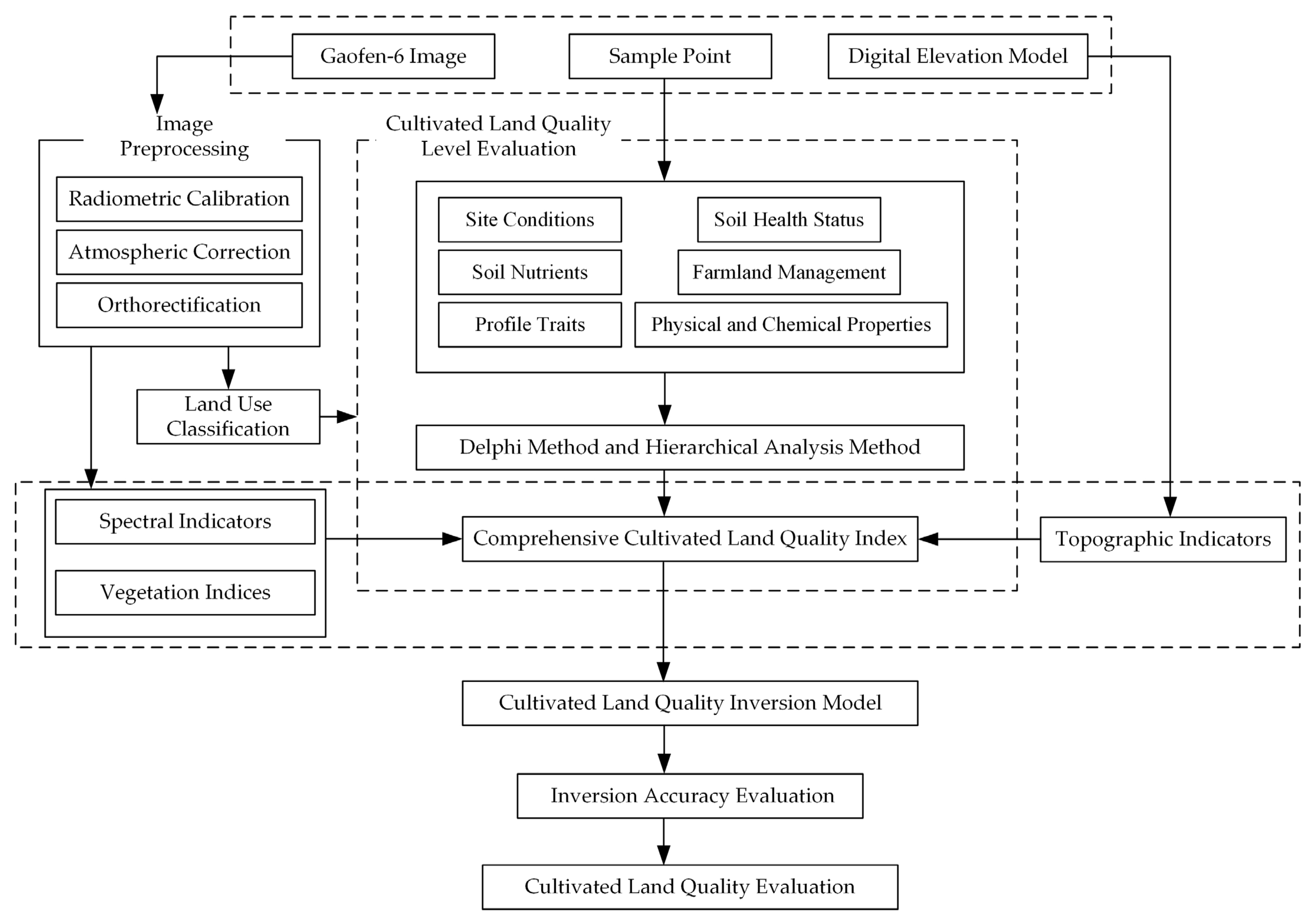
2. Materials and Methods
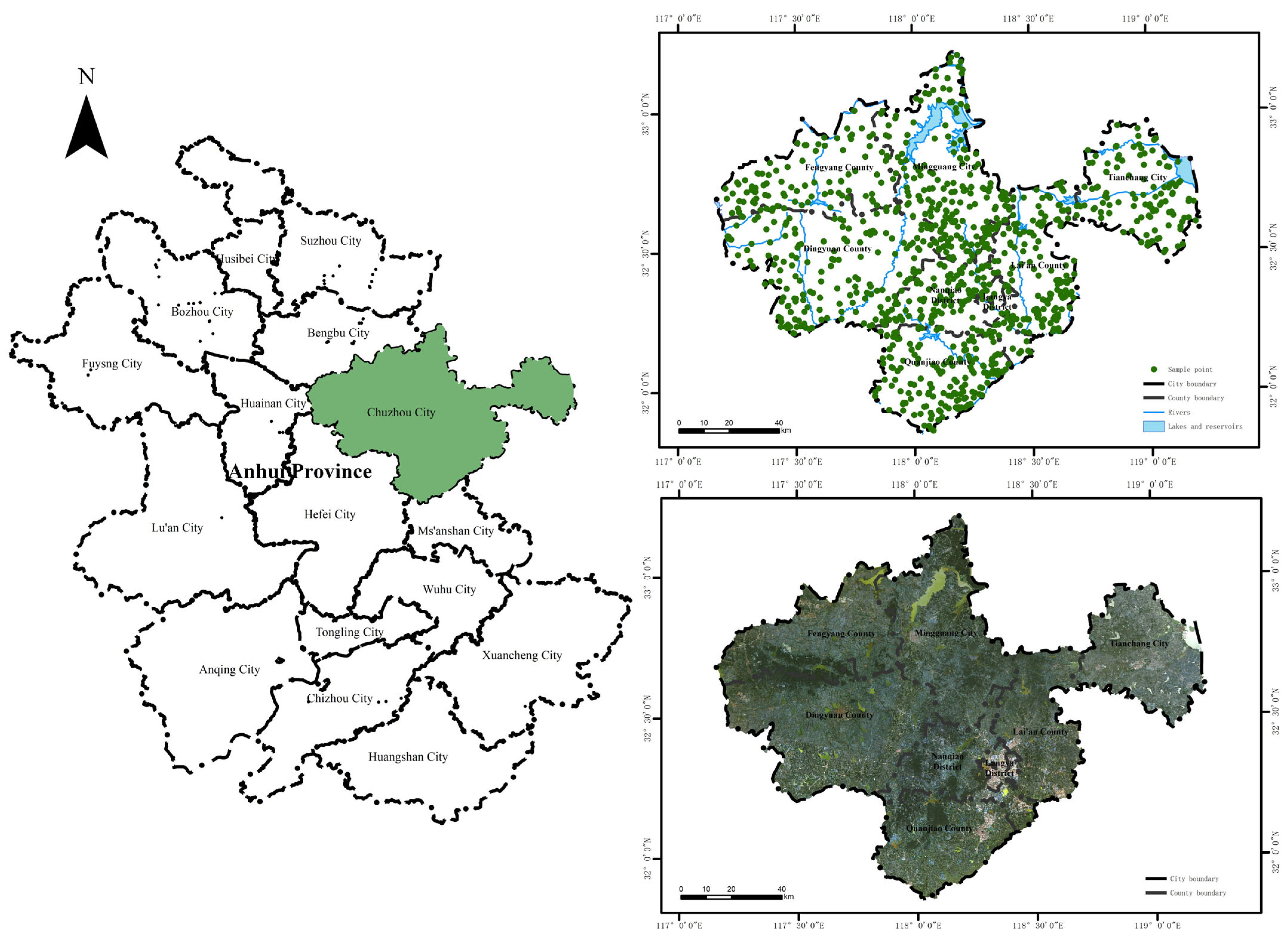
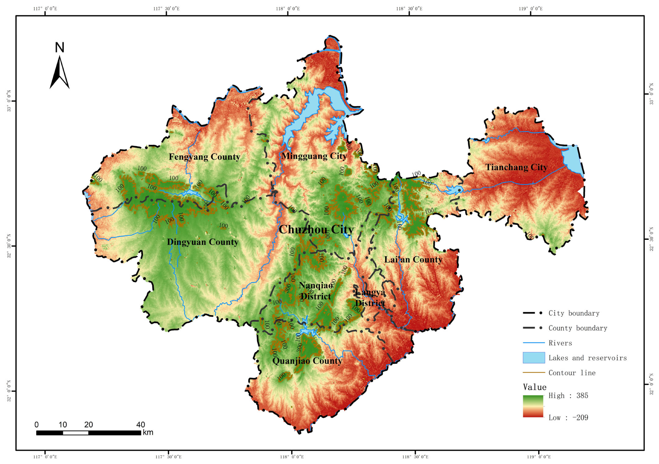
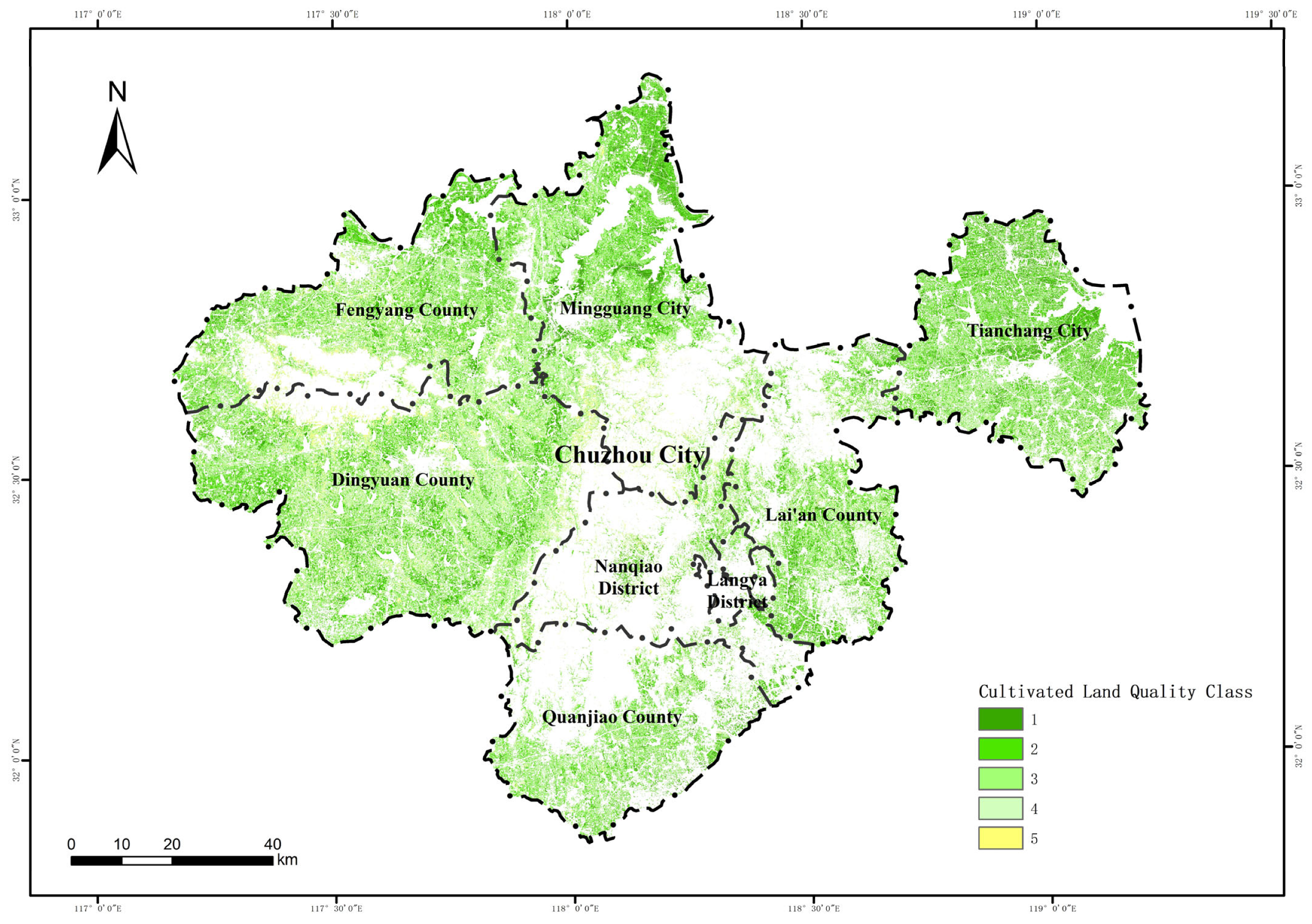
2.1. Study Area
2.2. Sample Point
2.3. Image Data Acquisition and Preprocessing
2.4. Spectral Indicators and Topographic Indicators
2.5. Land Use Classification
2.6. Cultivated Land Quality Level Evaluation
2.7. Cultivated Land Quality Inversion Model
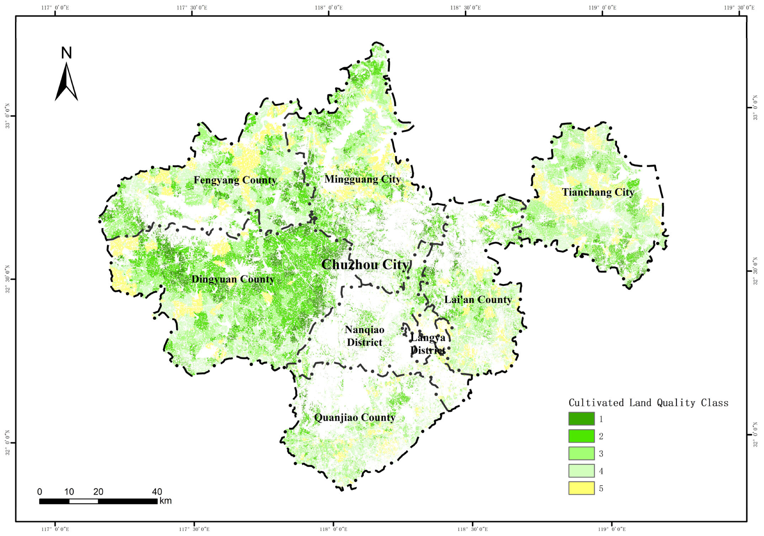
3. Results
4. Discussion
5. Conclusions
Author Contributions
Funding
Data Availability Statement
Conflicts of Interest
References
- Cristina Rulli, M.; D’Odorico, P. Food appropriation through large scale land acquisitions. Environ. Res. Lett. 2014, 9, 064030. [Google Scholar] [CrossRef]
- Foley, J.A.; Ramankutty, N.; Brauman, K.A.; Cassidy, E.S.; Gerber, J.S.; Johnston, M.; Mueller, N.D.; O’Connell, C.; Ray, D.K.; West, P.C.; et al. Solutions for a cultivated planet. Nature 2011, 478, 337–342. [Google Scholar] [CrossRef]
- Rinot, O.; Levy, G.J.; Steinberger, Y.; Svoray, T.; Eshel, G. Soil health assessment: A critical review of current methodologies and a proposed new approach. Sci. Total Environ. 2019, 648, 1484–1491. [Google Scholar] [CrossRef]
- Fathizad, H.; Ardakani, M.A.H.; Heung, B.; Sodaiezadeh, H.; Rahmani, A.; Fathabadi, A.; Scholten, T.; Taghizadeh-Mehrjardi, R. Spatio-temporal dynamic of soil quality in the central Iranian desert modeled with machine learning and digital soil assessment techniques. Ecol. Indic. 2020, 118, 106736. [Google Scholar] [CrossRef]
- Everest, T.; Sungur, A.; Özcan, H. Applying the Best–Worst Method for land evaluation: A case study for paddy cultivation in northwest Turkey. Int. J. Environ. Sci. Technol. 2021, 19, 3233–3246. [Google Scholar] [CrossRef]
- Tashayo, B.; Honarbakhsh, A.; Azma, A.; Akbari, M. Combined Fuzzy AHP–GIS for Agricultural Land Suitability Modeling for a Watershed in Southern Iran. Environ. Manag. 2020, 66, 364–376. [Google Scholar] [CrossRef] [PubMed]
- Qader, S.H.; Dash, J.; Atkinson, P.M. Forecasting wheat and barley crop production in arid and semi-arid regions using remotely sensed primary productivity and crop phenology: A case study in Iraq. Sci. Total Environ. 2018, 613–614, 250–262. [Google Scholar] [CrossRef]
- Liu, L.; Zhou, D.; Chang, X.; Lin, Z. A new grading system for evaluating China’s cultivated land quality. Land Degrad. Dev. 2020, 31, 1482–1501. [Google Scholar] [CrossRef]
- Chen, S.; Lin, B.; Li, Y.; Zhou, S. Spatial and temporal changes of soil properties and soil fertility evaluation in a large grain-production area of subtropical plain, China. Geoderma 2020, 357, 113937. [Google Scholar] [CrossRef]
- Hoyos, L.; Cabido, M.; Cingolani, A. A Multivariate Approach to Study Drivers of Land-Cover Changes through Remote Sensing in the Dry Chaco of Argentina. ISPRS Int. J. Geo-Inf. 2018, 7, 170. [Google Scholar] [CrossRef]
- Tong, X.-Y.; Xia, G.-S.; Lu, Q.; Shen, H.; Li, S.; You, S.; Zhang, L. Land-cover classification with high-resolution remote sensing images using transferable deep models. Remote Sens. Environ. 2020, 237, 111322. [Google Scholar] [CrossRef]
- Zhang, S.; Ban, X.; Xiao, T.; Huang, L.; Zhao, J.; Huang, W.; Liang, D. Identification of Soybean Planting Areas Combining Fused Gaofen-1 Image Data and U-Net Model. Agronomy 2023, 13, 863. [Google Scholar] [CrossRef]
- Khosravi, V.; Doulati Ardejani, F.; Yousefi, S.; Aryafar, A. Monitoring soil lead and zinc contents via combination of spectroscopy with extreme learning machine and other data mining methods. Geoderma 2018, 318, 29–41. [Google Scholar] [CrossRef]
- Binte Mostafiz, R.; Noguchi, R.; Ahamed, T. Agricultural Land Suitability Assessment Using Satellite Remote Sensing-Derived Soil-Vegetation Indices. Land 2021, 10, 223. [Google Scholar] [CrossRef]
- Peng, Y.; Liu, Z.; Lin, C.; Hu, Y.; Zhao, L.; Zou, R.; Wen, Y.; Mao, X. A New Method for Estimating Soil Fertility Using Extreme Gradient Boosting and a Backpropagation Neural Network. Remote Sens. 2022, 14, 3311. [Google Scholar] [CrossRef]
- Duan, D.; Sun, X.; Liang, S.; Sun, J.; Fan, L.; Chen, H.; Xia, L.; Zhao, F.; Yang, W.; Yang, P. Spatiotemporal Patterns of Cultivated Land Quality Integrated with Multi-Source Remote Sensing: A Case Study of Guangzhou, China. Remote Sens. 2022, 14, 1250. [Google Scholar] [CrossRef]
- Liu, S.; Peng, Y.; Xia, Z.; Hu, Y.; Wang, G.; Zhu, A.; Liu, Z. The GA-BPNN-Based Evaluation of Cultivated Land Quality in the PSR Framework Using Gaofen-1 Satellite Data. Sensors 2019, 19, 5127. [Google Scholar] [CrossRef]
- Belgiu, M.; Drăguţ, L. Random forest in remote sensing: A review of applications and future directions. ISPRS J. Photogramm. Remote Sens. 2016, 114, 24–31. [Google Scholar] [CrossRef]
- NY/T 1377-2007; Determination of pH in Soil. Ministry of Agriculture and Rural Affairs, PRC: Beijing, China, 2007.
- NY/T 1121.6-2006; Soil Testing Part 6: Method for Determination of Soil Organic Matter. Ministry of Agriculture and Rural Affairs, PRC: Beijing, China, 2006.
- NY/T 1121.7-2014; Soil testing—Part 7: Method for Determination of Available Phosphorous in Soil. Ministry of Agriculture and Rural Affairs, PRC: Beijing, China, 2014.
- NY/T 889-2004; Determination of Exchangeable Potassium and Non-Exchangeable Potassium Content in Soil. Ministry of Agriculture and Rural Affairs, PRC: Beijing, China, 2004.
- Marti, J.; Bort, J.; Slafer, G.A.; Araus, J.L. Can wheat yield be assessed by early measurements of Normalized Difference Vegetation Index? Ann. Appl. Biol. 2007, 150, 253–257. [Google Scholar] [CrossRef]
- Richardson, A.J.; Wiegand, C.L. Distinguishing vegetation from soil background information. Photogramm. Eng. Remote Sens. 1977, 43, 1541–1552. [Google Scholar]
- Pearson, R.L.; Miller, L.D. Remote Mapping of Standing Crop Biomass for Estimation of the Productivity of the Shortgrass Prairie. Remote Sens. Environ. 1972, VIII, 1355. [Google Scholar]
- Zhang, Y.J.; Alfredo, R.H.; Kamel, D.; Tomoaki, M. Development of a two-band enhanced vegetation index without a blue band. Remote Sens. Environ. 2008, 112, 3833–3845. [Google Scholar]
- Huete, A.R. A soil-adjusted vegetation index (SAVI). Remote Sens. Environ. 1988, 25, 295–309. [Google Scholar] [CrossRef]
- Zhu, P.; Zhang, G.; Yang, Y.; Wang, C.; Chen, S.; Wan, Y. Infiltration properties affected by slope position on cropped hillslopes. Geoderma 2023, 432, 116379. [Google Scholar] [CrossRef]
- Moore, I.D.; Grayson, R.B.; Ladson, A.R. Digital terrain modelling: A review of hydrological, geomorphological, and biological applications. Hydrol. Process. 1991, 5, 3–30. [Google Scholar] [CrossRef]
- Jaafarzadeh, M.S.; Tahmasebipour, N.; Haghizadeh, A.; Pourghasemi, H.R.; Rouhani, H. Groundwater recharge potential zonation using an ensemble of machine learning and bivariate statistical models. Sci. Rep. 2021, 11, 5587. [Google Scholar] [CrossRef]
- Arabameri, A.; Rezaei, K.; Cerda, A.; Lombardo, L.; Rodrigo-Comino, J. GIS-based groundwater potential mapping in Shahroud plain, Iran. A comparison among statistical (bivariate and multivariate), data mining and MCDM approaches. Sci. Total Environ. 2019, 658, 160–177. [Google Scholar] [CrossRef]
- Wang, L.; Wang, J.; Liu, Z.; Zhu, J.; Qin, F. Evaluation of a deep-learning model for multispectral remote sensing of land use and crop classification. Crop J. 2022, 10, 1435–1451. [Google Scholar] [CrossRef]
- Deng, Z.; Lu, Z.; Wang, G.; Wang, D.; Ding, Z.; Zhao, H.; Xu, H.; Shi, Y.; Cheng, Z.; Zhao, X. Extraction of fractional vegetation cover in arid desert area based on Chinese GF-6 satellite. Open Geosci. 2021, 13, 416–430. [Google Scholar] [CrossRef]
- Vogel, H.-J.; Bartke, S.; Daedlow, K.; Helming, K.; Kögel-Knabner, I.; Lang, B.; Rabot, E.; Russell, D.; Stößel, B.; Weller, U.; et al. A systemic approach for modeling soil functions. Soil 2018, 4, 83–92. [Google Scholar] [CrossRef]
- Raiesi, F.; Kabiri, V. Identification of soil quality indicators for assessing the effect of different tillage practices through a soil quality index in a semi-arid environment. Ecol. Indic. 2016, 71, 198–207. [Google Scholar] [CrossRef]
- Greiner, L.; Nussbaum, M.; Papritz, A.; Fraefel, M.; Zimmermann, S.; Schwab, P.; Grêt-Regamey, A.; Keller, A. Assessment of soil multi-functionality to support the sustainable use of soil resources on the Swiss Plateau. Geoderma Reg. 2018, 14, e00181. [Google Scholar] [CrossRef]
- Li, C.; Wang, J.; Ge, L.; Zhou, Y.; Zhou, S. Optimization of Sample Construction Based on NDVI for Cultivated Land Quality Prediction. Int. J. Environ. Res. Public Health 2022, 19, 7781. [Google Scholar] [CrossRef]
- Eilola, S.; Käyhkö, N.; Fagerholm, N. Lessons learned from participatory land use planning with high-resolution remote sensing images in Tanzania: Practitioners’ and participants’ perspectives. Land Use Policy 2021, 109, 105649. [Google Scholar] [CrossRef]
- Blickensdörfer, L.; Schwieder, M.; Pflugmacher, D.; Nendel, C.; Erasmi, S.; Hostert, P. Mapping of crop types and crop sequences with combined time series of Sentinel-1, Sentinel-2 and Landsat 8 data for Germany. Remote Sens. Environ. 2022, 269, 112831. [Google Scholar] [CrossRef]
- Griffiths, P.; Nendel, C.; Hostert, P. Intra-annual reflectance composites from Sentinel-2 and Landsat for national-scale crop and land cover mapping. Remote Sens. Environ. 2019, 220, 135–151. [Google Scholar] [CrossRef]


| Serial Number | Image Acquisition Time | Sensor Type | Spatial Resolution (Meter) |
|---|---|---|---|
| 1 | 19 February 2021 | PMS | 2 |
| 2 | 24 March 2021 | PMS | 2 |
| 3 | 24 March 2021 | PMS | 2 |
| 4 | 22 June 2021 | PMS | 2 |
| 5 | 25 November 2021 | PMS | 2 |
| 6 | 25 November 2021 | PMS | 2 |
| 7 | 25 November 2021 | WFV | 16 |
| 8 | 25 November 2021 | WFV | 16 |
| Sensor Type | Band | Wavelength (μm) | Spatial Resolution (Meter) | Gain |
|---|---|---|---|---|
| PMS | Pan | 0.45–0.90 | 2 | 0.0577 |
| Blue | 0.45–0.52 | 8 | 0.0821 | |
| Green | 0.52–0.60 | 8 | 0.0671 | |
| Red | 0.63–0.69 | 8 | 0.0518 | |
| Near Infrared | 0.76–0.90 | 8 | 0.031 | |
| WFV | B1 | 0.45–0.52 | 16 | 0.0633 |
| B2 | 0.52–0.69 | 16 | 0.0532 | |
| B3 | 0.63–0.69 | 16 | 0.0508 | |
| B4 | 0.77–0.89 | 16 | 0.0325 | |
| B5 | 0.69–0.73 | 16 | 0.0523 | |
| B6 | 0.73–0.77 | 16 | 0.0463 | |
| B7 | 0.40–0.45 | 16 | 0.067 | |
| B8 | 0.59–0.63 | 16 | 0.0591 |
| Vegetation Index | Abbreviation | Calculation Formula | Reference |
|---|---|---|---|
| Normalized vegetation index | NDVI | NDVI = (B4 − B3)/(B4 + B3) | [23] |
| Difference vegetation index | DVI | DVI = B4 − B3 | [24] |
| Ratio vegetation index | RVI | RVI = B4/B3 | [25] |
| Enhanced Vegetation Index | EVI | EVI = 2.5(B4 − B3)/(B4 + 6.0B3 − 7.5B1 + 1) | [26] |
| Soil-corrected vegetation index | SAVI | SAVI = (B4 − B3)/(B4 + B3 + 0.5)(1 + 0.5) | [27] |
| Guideline Layer | Indicator Layer | Index Type | Index Weight |
|---|---|---|---|
| Site conditions | Parts of the terrain | textual | 0.0988 |
| Farmland forestry reticulation | textual | 0.0408 | |
| Profile traits | Effective soil layer thickness | numerical | 0.0413 |
| Texture configuration | textual | 0.0518 | |
| Obstacle factors | textual | 0.0536 | |
| Physical and chemical properties | Plough layer texture | textual | 0.0797 |
| Soil bulk density | numerical | 0.0558 | |
| Soil acidity and alkalinity | numerical | 0.0491 | |
| Soil nutrients | Soil organic matter | numerical | 0.1221 |
| Soil available phosphorus | numerical | 0.0565 | |
| Soil available potassium | numerical | 0.0594 | |
| Soil health status | Biodiversity | textual | 0.0345 |
| Cleanliness | textual | 0.0335 | |
| Farmland management | Irrigation capacity | textual | 0.1089 |
| Drainage capacity | textual | 0.1141 |
| Serial Number | Cultivated Land Quality Level | Comprehensive Index Range |
|---|---|---|
| 1 | Higher | ≥0.8924 |
| 2 | High | 0.8431–0.8924 |
| 3 | Medium | 0.7939–0.8431 |
| 4 | Low | 0.7446–0.7939 |
| 5 | Lower | <0.7446 |
| Groups | Model Input Variables | Performance Indicator | |
|---|---|---|---|
| R2 | RMSE | ||
| MSVT-CLQ | soil organic matter, soil bulk density, effective soil thickness, pH, B1, B3, B4, B6, NDVI, DVI, RVI, EVI, SAVI, slope, TWI, SPI | 0.93 | 1.42 |
| SVT-CLQ | B4, B6, EVI, TWI | 0.91 | 3.13 |
| Quality Level of Cultivated Land | Proportion of Area at Different Levels | ||
|---|---|---|---|
| CLQ | MSVT-CLQ | SVT-CLQ | |
| 1 | 7.00% | 17.00% | 12.00% |
| 2 | 26.00% | 32.00% | 25.00% |
| 3 | 27.00% | 25.00% | 30.00% |
| 4 | 25.00% | 14.00% | 23.00% |
| 5 | 15.00% | 12.00% | 10.00% |
Disclaimer/Publisher’s Note: The statements, opinions and data contained in all publications are solely those of the individual author(s) and contributor(s) and not of MDPI and/or the editor(s). MDPI and/or the editor(s) disclaim responsibility for any injury to people or property resulting from any ideas, methods, instructions or products referred to in the content. |
© 2023 by the authors. Licensee MDPI, Basel, Switzerland. This article is an open access article distributed under the terms and conditions of the Creative Commons Attribution (CC BY) license (https://creativecommons.org/licenses/by/4.0/).
Share and Cite
Tang, M.; Wang, Q.; Mei, S.; Ying, C.; Gao, Z.; Ma, Y.; Hu, H. Research on the Inversion Model of Cultivated Land Quality Using High-Resolution Remote Sensing Data. Agronomy 2023, 13, 2871. https://doi.org/10.3390/agronomy13122871
Tang M, Wang Q, Mei S, Ying C, Gao Z, Ma Y, Hu H. Research on the Inversion Model of Cultivated Land Quality Using High-Resolution Remote Sensing Data. Agronomy. 2023; 13(12):2871. https://doi.org/10.3390/agronomy13122871
Chicago/Turabian StyleTang, Mengmeng, Qiang Wang, Shuai Mei, Chunyang Ying, Zhengbao Gao, Youhua Ma, and Hongxiang Hu. 2023. "Research on the Inversion Model of Cultivated Land Quality Using High-Resolution Remote Sensing Data" Agronomy 13, no. 12: 2871. https://doi.org/10.3390/agronomy13122871
APA StyleTang, M., Wang, Q., Mei, S., Ying, C., Gao, Z., Ma, Y., & Hu, H. (2023). Research on the Inversion Model of Cultivated Land Quality Using High-Resolution Remote Sensing Data. Agronomy, 13(12), 2871. https://doi.org/10.3390/agronomy13122871