
Mapping Ecological Focus Areas within the EU CAP Controls Framework by Copernicus Sentinel-2 Data


Abstract
:1. Introduction
1.1. Ecological Focus Areas within CAP
1.2. Copernicus Satellite Data in the EFA Controls Context
1.3. Goals
2. Materials and Methods
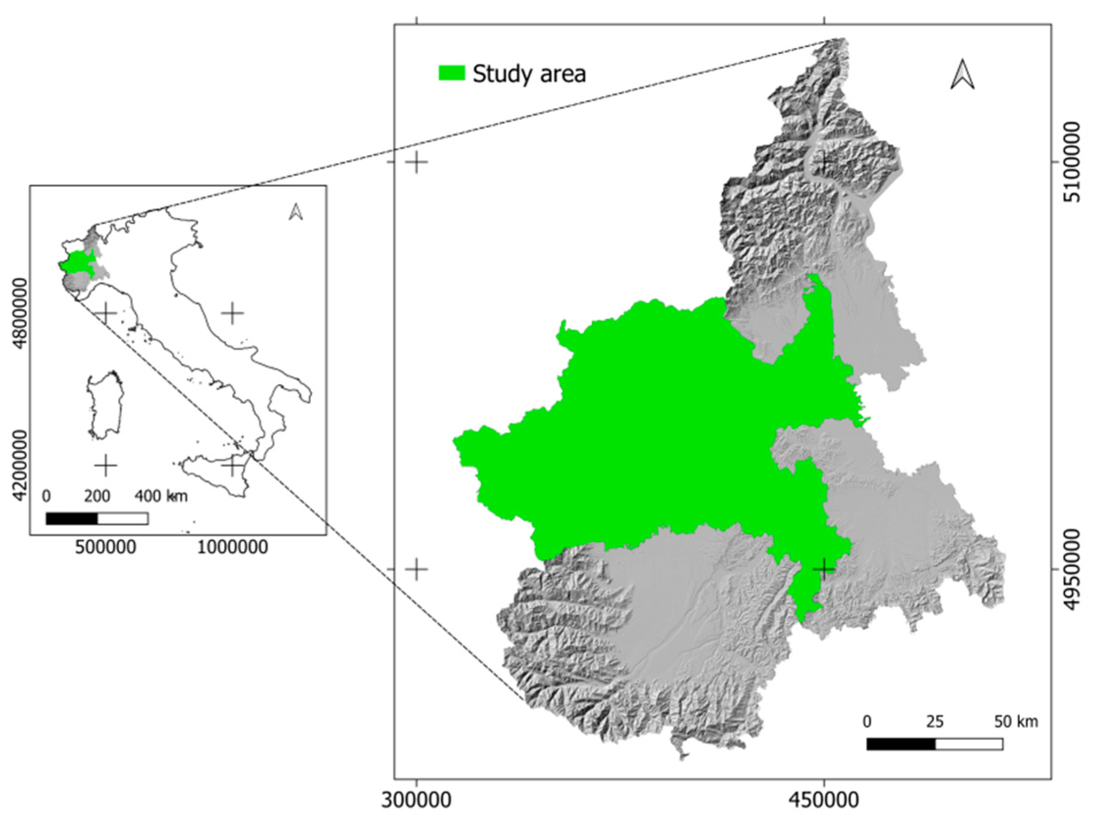
2.1. Study Area
2.2. Available Data
2.2.1. Satellite Data
2.2.2. EFA Maps from Farmers
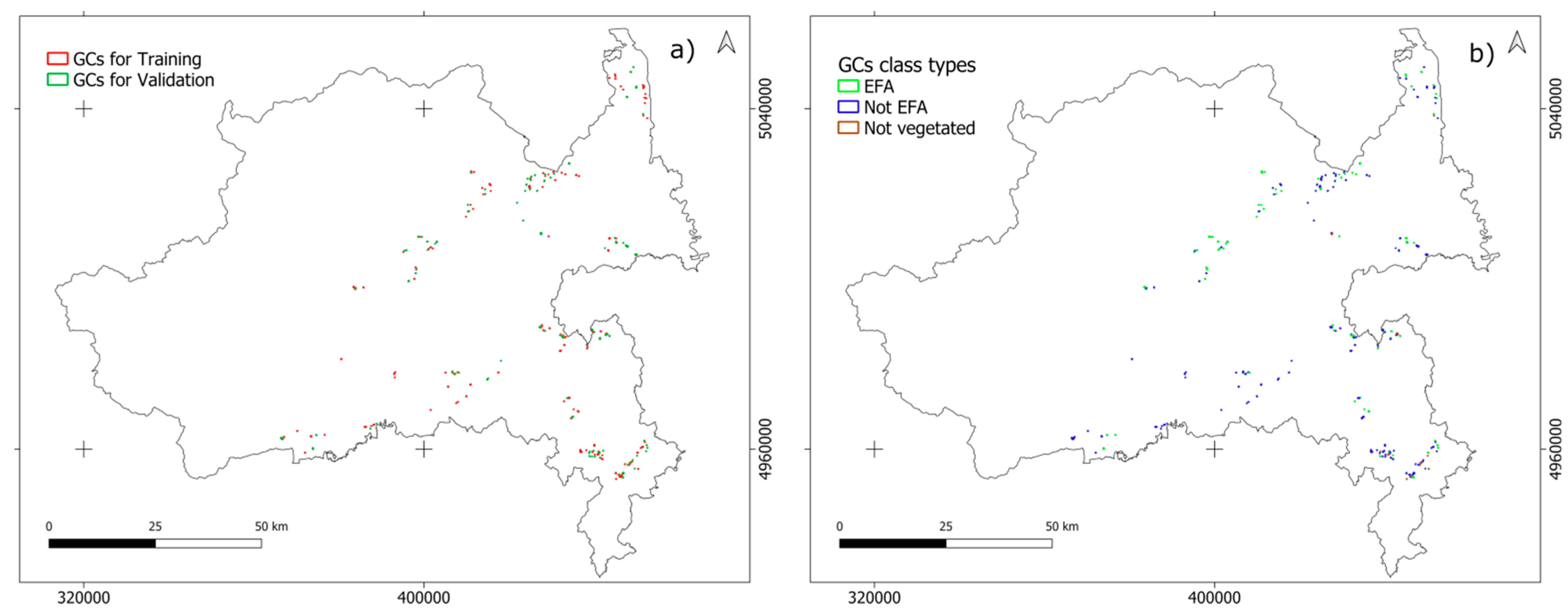
2.2.3. Ground Data
2.3. Data Processing
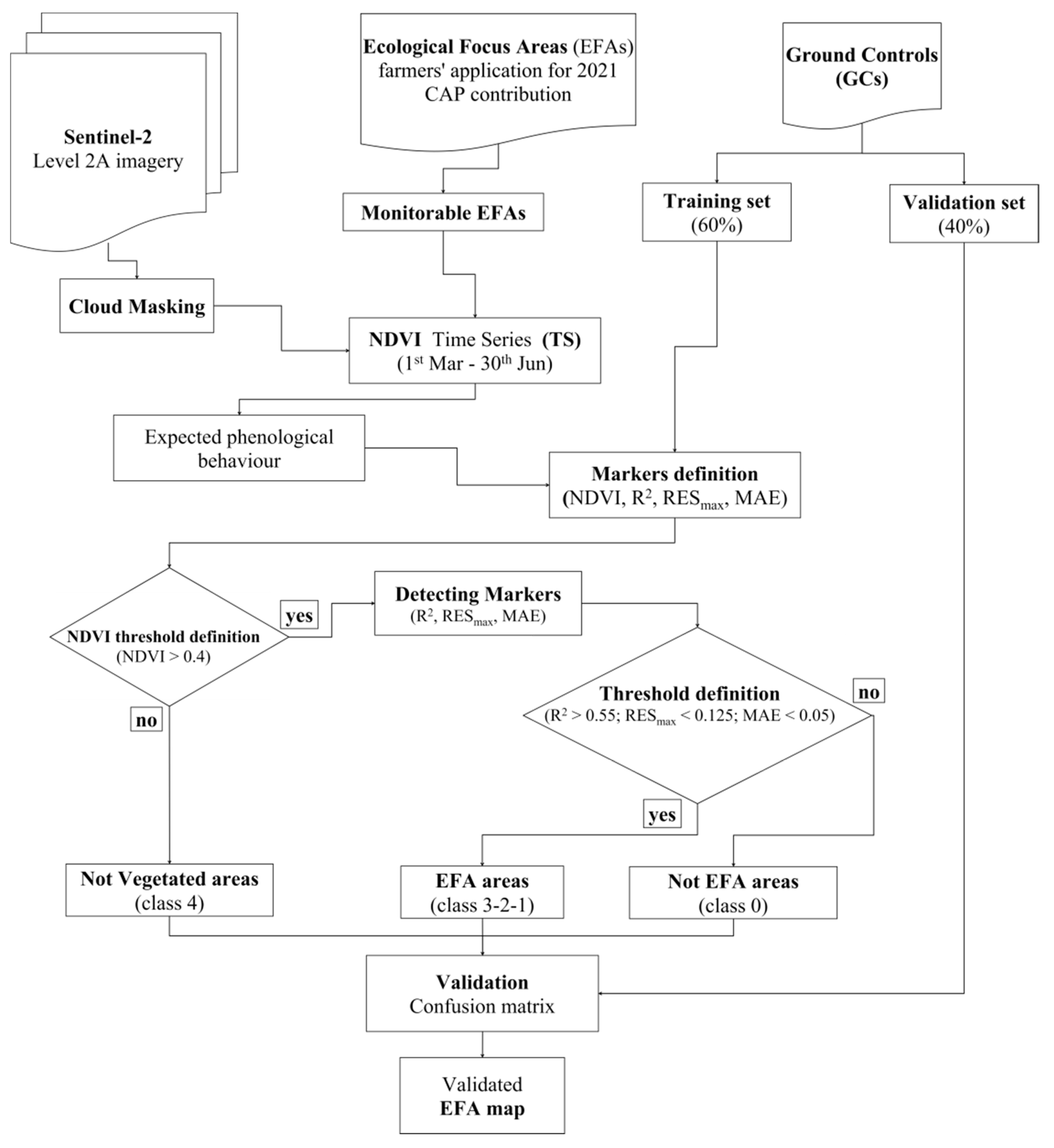
2.3.1. Composing NDVI Time Series
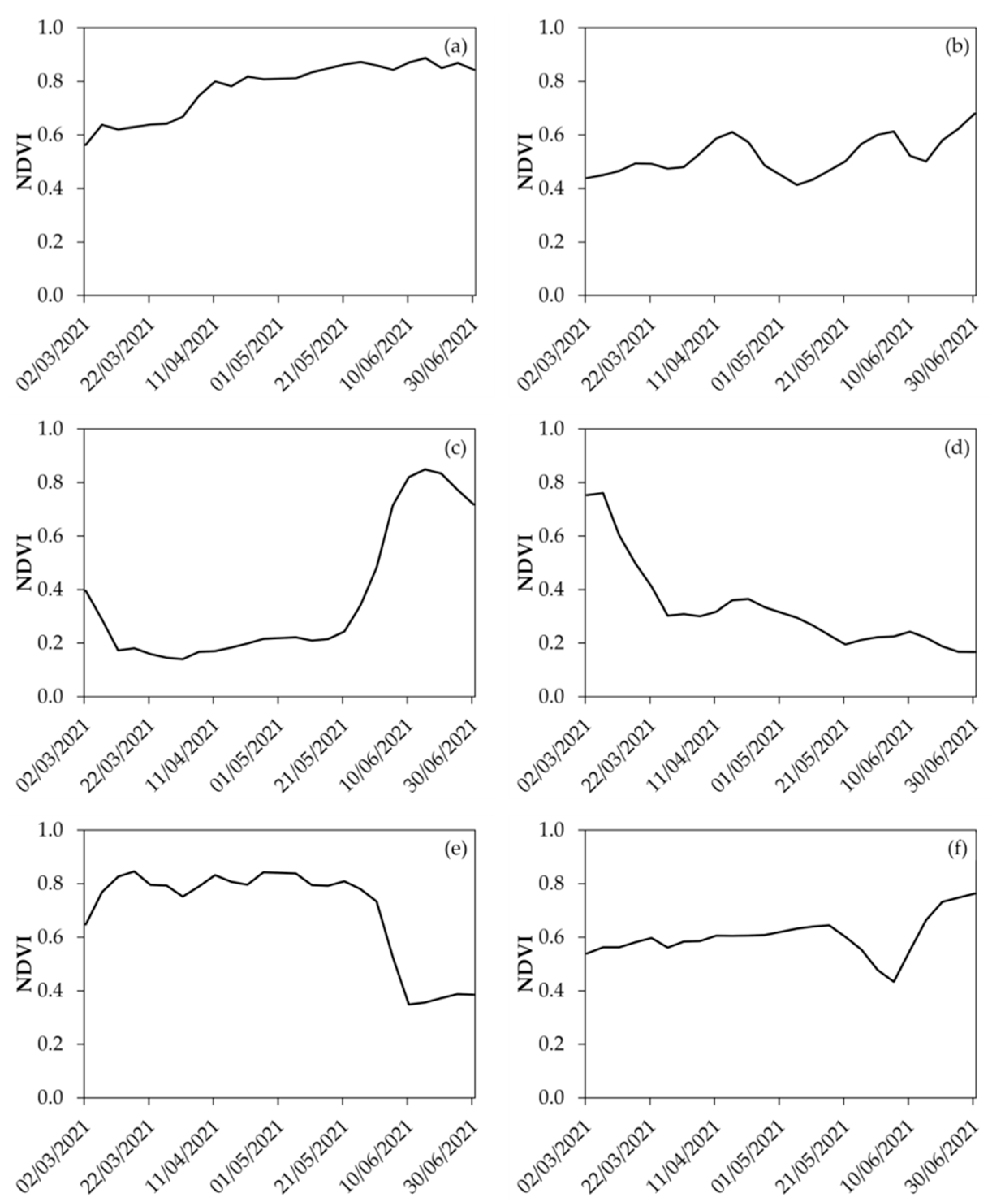
2.3.2. Looking for Markers within NDVI Temporal Profiles
2.3.3. Detecting Markers
2.3.4. From Residual Statistics to Markers
3. Results and Discussions
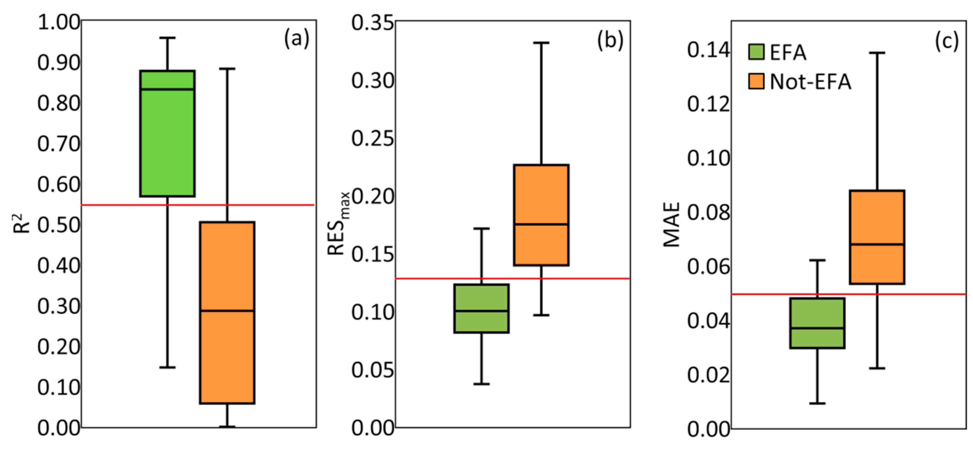
3.1. Threshold Definition
3.2. Classification and Validation
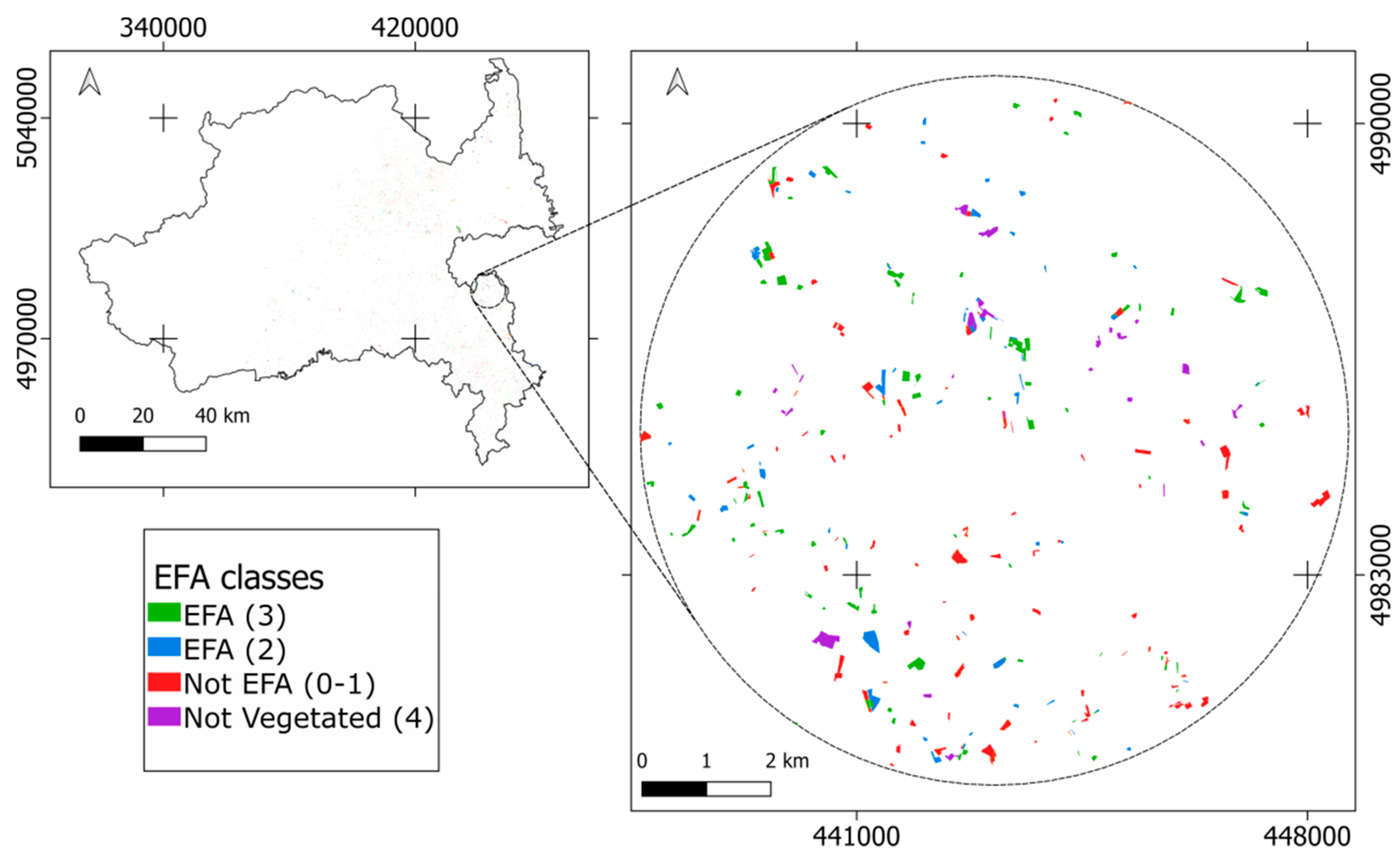
3.3. Interpreting EFA Map
4. Conclusions
Author Contributions
Funding
Informed Consent Statement
Data Availability Statement
Acknowledgments
Conflicts of Interest
References
- Ackrill, R. Common Agricultural Policy; A&C Black: London, UK, 2000; Volume 9. [Google Scholar]
- Grant, W. The Common Agricultural Policy; Macmillan International Higher Education: London, UK, 1997. [Google Scholar]
- Dupraz, P.; Guyomard, H. Environment and Climate in the Common Agricultural Policy. EuroChoices 2019, 18, 18–25. [Google Scholar] [CrossRef] [Green Version]
- Gowdy, J.M. The Value of Biodiversity: Markets, Society, and Ecosystems. Land Econ. 1997, 73, 25–41. [Google Scholar] [CrossRef]
- Lowe, P.; Feindt, P.H.; Vihinen, H. Introduction: Greening the Countryside? Changing Frameworks of EU Agricultural Policy. Public Adm. 2010, 88, 287–295. [Google Scholar] [CrossRef] [PubMed]
- Westhoek, H.; Van Zeijts, H.; Witmer, M.; Van den Berg, M.; Overmars, K.; Van der Esch, S.; Van der Bilt, W. Greening the CAP. An Analysis of the Effects of the European Commission’s Proposals for the Common Agricultural Policy 2014–2020; PBL Netherlands Environmental Assessment Agency: The Hague, The Netherlands, 2012. [Google Scholar]
- Gocht, A.; Ciaian, P.; Bielza, M.; Terres, J.-M.; Röder, N.; Himics, M.; Salputra, G. EU-Wide Economic and Environmental Impacts of CAP Greening with High Spatial and Farm-Type Detail. J. Agric. Econ. 2017, 68, 651–681. [Google Scholar] [CrossRef]
- Singh, M.; Marchis, A.; Capri, E. Greening, New Frontiers for Research and Employment in the Agro-Food Sector. Sci. Total Environ. 2014, 472, 437–443. [Google Scholar] [CrossRef]
- Wetzels, H. CAP Beyond the EU; Heinrich-Böll-Stiftung European Union: Ixelles, Belgium, 2021. [Google Scholar]
- Cagliero, R.; Licciardo, F.; Legnini, M. The Evaluation Framework in the New CAP 2023–2027: A Reflection in the Light of Lessons Learned from Rural Development. Sustainability 2021, 13, 5528. [Google Scholar] [CrossRef]
- Disposizioni Nazionali di Applicazione del Regolamento (UE) n. 1307/2013 del Parlamento Europeo e del Consiglio, del 17 Dicembre 2013; European Union: Brussels, Beglium, 2018.
- Regolamento Delegato (UE) n. 639/2014 della Commissione, dell’11 Marzo 2014, che Integra il Regolamento (UE) N. 1307/2013 del PARLAMENTO Europeo e del Consiglio Recante Norme sui Pagamenti Diretti Agli Agricoltori nell’Ambito dei Regimi di Sostegno Previsti dalla Politica Agricola Comune e che Modifica l’Allegato X di Tale Regolamento. 47; European Union: Brussels, Beglium, 2014.
- Zinngrebe, Y.; Pe’er, G.; Schueler, S.; Schmitt, J.; Schmidt, J.; Lakner, S. The EU’s Ecological Focus Areas—How Experts Explain Farmers’ Choices in Germany. Land Use Policy 2017, 65, 93–108. [Google Scholar] [CrossRef]
- Pe’Er, G.; Zinngrebe, Y.; Hauck, J.; Schindler, S.; Dittrich, A.; Zingg, S.; Tscharntke, T.; Oppermann, R.; Sutcliffe, L.M.; Sirami, C. Adding Some Green to the Greening: Improving the EU’s Ecological Focus Areas for Biodiversity and Farmers. Conserv. Lett. 2017, 10, 517–530. [Google Scholar] [CrossRef]
- Campinas, M.; Rosa, M.J. Assessing PAC Contribution to the NOM Fouling Control in PAC/UF Systems. Water Res. 2010, 44, 1636–1644. [Google Scholar] [CrossRef]
- Schiavon, E.; Taramelli, A.; Tornato, A.; Pierangeli, F. Monitoring Environmental and Climate Goals for European Agriculture: User Perspectives on the Optimization of the Copernicus Evolution Offer. J. Environ. Manag. 2021, 296, 113121. [Google Scholar] [CrossRef]
- Aschbacher, J. ESA’s Earth Observation Strategy and Copernicus. In Satellite Earth Observations and Their Impact on Society and Policy; Springer: Singapore, 2017; pp. 81–86. [Google Scholar]
- Bannari, A.; Morin, D.; Bonn, F.; Huete, A. A Review of Vegetation Indices. Remote Sens. Rev. 1995, 13, 95–120. [Google Scholar] [CrossRef]
- Leprieur, C.; Verstraete, M.M.; Pinty, B. Evaluation of the Performance of Various Vegetation Indices to Retrieve Vegetation Cover from AVHRR Data. Remote Sens. Rev. 1994, 10, 265–284. [Google Scholar] [CrossRef]
- Misra, G.; Cawkwell, F.; Wingler, A. Status of Phenological Research Using Sentinel-2 Data: A Review. Remote Sens. 2020, 12, 2760. [Google Scholar] [CrossRef]
- Boori, M.S.; Choudhary, K.; Paringer, R.; Sharma, A.K.; Kupriyanov, A.; Corgne, S. Monitoring Crop Phenology Using NDVI Time Series from Sentinel 2 Satellite Data. In Proceedings of the 2019 5th International Conference on Frontiers of Signal Processing (ICFSP), Marseille, France, 18–20 September 2019; pp. 62–66. [Google Scholar]
- Zhao, Y.; Potgieter, A.B.; Zhang, M.; Wu, B.; Hammer, G.L. Predicting Wheat Yield at the Field Scale by Combining High-Resolution Sentinel-2 Satellite Imagery and Crop Modelling. Remote Sens. 2020, 12, 1024. [Google Scholar] [CrossRef] [Green Version]
- Gómez, D.; Salvador, P.; Sanz, J.; Casanova, J.L. Potato Yield Prediction Using Machine Learning Techniques and Sentinel 2 Data. Remote Sens. 2019, 11, 1745. [Google Scholar] [CrossRef] [Green Version]
- Parida, B.R.; Kumar, A.; Ranjan, A.K. Crop Types Discrimination and Yield Prediction Using Sentinel-2 Data and AquaCrop Model in Hazaribagh District, Jharkhand. KN J. Cartogr. Geogr. Inf. 2021, 1–13. [Google Scholar] [CrossRef]
- Liu, R.; Huang, F.; Ren, Y.; Wang, P.; Zhang, J. Characterizing Ecosystem Functional Type Patterns Based on Subtractive Fuzzy Cluster Means Using Sentinel-2 Time-Series Data. J. Appl. Remote Sens. 2020, 14, 048505. [Google Scholar] [CrossRef]
- Andrew, M.E.; Wulder, M.A.; Nelson, T.A. Potential Contributions of Remote Sensing to Ecosystem Service Assessments. Prog. Phys. Geogr. 2014, 38, 328–353. [Google Scholar] [CrossRef] [Green Version]
- De Petris, S.; Sarvia, F.; Gullino, M.; Tarantino, E.; Borgogno-Mondino, E. Sentinel-1 Polarimetry to Map Apple Orchard Damage after a Storm. Remote Sens. 2021, 13, 1030. [Google Scholar] [CrossRef]
- Sarvia, F.; De Petris, S.; Borgogno Mondino, E. Multi-Scale Remote Sensing to Support Insurance Policies in Agriculture: From Mid-Term to Instantaneous Deductions. GISci. Remote Sens. 2020, 57, 770–784. [Google Scholar] [CrossRef]
- De Petris, S.; Sarvia, F.; Borgogno-Mondino, E. A New Index for Assessing Tree Vigour Decline Based on Sentinel-2 Multitemporal Data. Application to Tree Failure Risk Management. Remote Sens. Lett. 2021, 12, 58–67. [Google Scholar] [CrossRef]
- Momo, E.J.; De Petris, S.; Sarvia, F.; Borgogno-Mondino, E. Addressing Management Practices of Private Forests by Remote Sensing and Open Data: A Tentative Procedure. Remote Sens. Appl. Soc. Environ. 2021, 23, 100563. [Google Scholar] [CrossRef]
- Sarvia, F.; Petris, S.D.; Orusa, T.; Borgogno-Mondino, E. MAIA S2 Versus Sentinel 2: Spectral Issues and Their Effects in the Precision Farming Context. In Proceedings of the International Conference on Computational Science and Its Applications, Cagliari, Italy, 13–16 September 2021; pp. 63–77. [Google Scholar]
- Segarra, J.; Buchaillot, M.L.; Araus, J.L.; Kefauver, S.C. Remote Sensing for Precision Agriculture: Sentinel-2 Improved Features and Applications. Agronomy 2020, 10, 641. [Google Scholar] [CrossRef]
- Phiri, D.; Simwanda, M.; Salekin, S.; Nyirenda, V.R.; Murayama, Y.; Ranagalage, M. Sentinel-2 Data for Land Cover/Use Mapping: A Review. Remote Sens. 2020, 12, 2291. [Google Scholar] [CrossRef]
- Steinhausen, M.J.; Wagner, P.D.; Narasimhan, B.; Waske, B. Combining Sentinel-1 and Sentinel-2 Data for Improved Land Use and Land Cover Mapping of Monsoon Regions. Int. J. Appl. Earth Obs. Geoinf. 2018, 73, 595–604. [Google Scholar] [CrossRef]
- De Petris, S.; Boccardo, P.; Borgogno-Mondino, E. Detection and Characterization of Oil Palm Plantations through MODIS EVI Time Series. Int. J. Remote Sens. 2019, 40, 7297–7311. [Google Scholar] [CrossRef]
- Zheng, J.; Fu, H.; Li, W.; Wu, W.; Zhao, Y.; Dong, R.; Yu, L. Cross-Regional Oil Palm Tree Counting and Detection via a Multi-Level Attention Domain Adaptation Network. ISPRS J. Photogramm. Remote Sens. 2020, 167, 154–177. [Google Scholar] [CrossRef]
- Caballero, I.; Ruiz, J.; Navarro, G. Sentinel-2 Satellites Provide near-Real Time Evaluation of Catastrophic Floods in the West Mediterranean. Water 2019, 11, 2499. [Google Scholar] [CrossRef] [Green Version]
- De Petris, S.; Sarvia, F.; Borgogno Mondino, E. Multi-Temporal Mapping of Flood Damage to Crops Using Sentinel-1 Imagery: A Case Study of the Sesia River (October 2020). Remote Sens. Lett. 2021, 12, 459–469. [Google Scholar] [CrossRef]
- Campos-Taberner, M.; García-Haro, F.J.; Martínez, B.; Sánchez-Ruíz, S.; Gilabert, M.A. A Copernicus Sentinel-1 and Sentinel-2 Classification Framework for the 2020+ European Common Agricultural Policy: A Case Study in València (Spain). Agronomy 2019, 9, 556. [Google Scholar] [CrossRef] [Green Version]
- Sarvia, F.; Xausa, E.; Petris, S.D.; Cantamessa, G.; Borgogno-Mondino, E. A Possible Role of Copernicus Sentinel-2 Data to Support Common Agricultural Policy Controls in Agriculture. Agronomy 2021, 11, 110. [Google Scholar] [CrossRef]
- Kanjir, U.; \DJurić, N.; Veljanovski, T. Sentinel-2 Based Temporal Detection of Agricultural Land Use Anomalies in Support of Common Agricultural Policy Monitoring. ISPRS Int. J. Geo-Inf. 2018, 7, 405. [Google Scholar] [CrossRef] [Green Version]
- Bégué, A.; Arvor, D.; Bellon, B.; Betbeder, J.; De Abelleyra, D.; PD Ferraz, R.; Lebourgeois, V.; Lelong, C.; Simões, M.R.; Verón, S. Remote Sensing and Cropping Practices: A Review. Remote Sens. 2018, 10, 99. [Google Scholar] [CrossRef] [Green Version]
- Kaul, H.A.; Sopan, I. Land Use Land Cover Classification and Change Detection Using High Resolution Temporal Satellite Data. J. Environ. 2012, 1, 146–152. [Google Scholar]
- Kussul, N.; Lavreniuk, M.; Skakun, S.; Shelestov, A. Deep Learning Classification of Land Cover and Crop Types Using Remote Sensing Data. IEEE Geosci. Remote Sens. Lett. 2017, 14, 778–782. [Google Scholar] [CrossRef]
- Nguyen, T.T.; Hoang, T.D.; Pham, M.T.; Vu, T.T.; Nguyen, T.H.; Huynh, Q.-T.; Jo, J. Monitoring Agriculture Areas with Satellite Images and Deep Learning. Appl. Soft Comput. 2020, 95, 106565. [Google Scholar] [CrossRef]
- Gascon, F.; Cadau, E.; Colin, O.; Hoersch, B.; Isola, C.; Fernández, B.L.; Martimort, P. Copernicus Sentinel-2 Mission: Products, Algorithms and Cal/Val. In Earth Observing Systems XIX; International Society for Optics and Photonics: Bellingham, WA, USA, 2014; Volume 9218, p. 92181E. [Google Scholar]
- Delwart, S. SENTINEL-2 User Handbook. European Space Agency (ESA): Paris, France, 2015; Volume 1, pp. 1–64. [Google Scholar]
- Rouse, J.W.; Haas, R.H.; Schell, J.A.; Deering, D.W.; Harlan, J.C. Monitoring the Vernal Advancement and Retrogradation (Green Wave Effect) of Natural Vegetation; Technical Report No. E7410113; National Aeronautics and Space Administration: Washington, DC, USA, 1974. [Google Scholar]
- Richards, J.A.; Richards, J.A. Remote Sensing Digital Image Analysis; Springer: Berlin/Heidelberg, Germany, 1999; Volume 3. [Google Scholar]
- Shanmugapriya, P.; Rathika, S.; Ramesh, T.; Janaki, P. Applications of Remote Sensing in Agriculture-A Review. Int. J. Curr. Microbiol. Appl. Sci. 2019, 8, 2270–2283. [Google Scholar] [CrossRef]
- Veloso, A.; Mermoz, S.; Bouvet, A.; Le Toan, T.; Planells, M.; Dejoux, J.-F.; Ceschia, E. Understanding the Temporal Behavior of Crops Using Sentinel-1 and Sentinel-2-like Data for Agricultural Applications. Remote Sens. Environ. 2017, 199, 415–426. [Google Scholar] [CrossRef]
- Chen, J.; Jönsson, P.; Tamura, M.; Gu, Z.; Matsushita, B.; Eklundh, L. A Simple Method for Reconstructing a High-Quality NDVI Time-Series Data Set Based on the Savitzky–Golay Filter. Remote Sens. Environ. 2004, 91, 332–344. [Google Scholar] [CrossRef]
- Mishra, A.; Lu, Y.; Meng, J.; Anderson, A.W.; Ding, Z. Unified Framework for Anisotropic Interpolation and Smoothing of Diffusion Tensor Images. NeuroImage 2006, 31, 1525–1535. [Google Scholar] [CrossRef] [PubMed]
- Chen, Y.; Cao, R.; Chen, J.; Liu, L.; Matsushita, B. A Practical Approach to Reconstruct High-Quality Landsat NDVI Time-Series Data by Gap Filling and the Savitzky–Golay Filter. ISPRS J. Photogramm. Remote Sens. 2021, 180, 174–190. [Google Scholar] [CrossRef]
- Santos, L.A.; Ferreira, K.R.; Camara, G.; Picoli, M.C.; Simoes, R.E. Quality Control and Class Noise Reduction of Satellite Image Time Series. ISPRS J. Photogramm. Remote Sens. 2021, 177, 75–88. [Google Scholar] [CrossRef]
- Conrad, O.; Bechtel, B.; Bock, M.; Dietrich, H.; Fischer, E.; Gerlitz, L.; Wehberg, J.; Wichmann, V.; Böhner, J. System for Automated Geoscientific Analyses (SAGA) v. 2.1. 4. Geosci. Model Dev. 2015, 8, 1991–2007. [Google Scholar] [CrossRef] [Green Version]
- Gianinetto, M.; Rusmini, M.; Candiani, G.; Via, G.D.; Frassy, F.; Maianti, P.; Marchesi, A.; Nodari, F.R.; Dini, L. Hierarchical Classification of Complex Landscape with VHR Pan-Sharpened Satellite Data and OBIA Techniques. Eur. J. Remote Sens. 2014, 47, 229–250. [Google Scholar] [CrossRef] [Green Version]
- Borgogno-Mondino, E.; Lessio, A.; Gomarasca, M.A. A Fast Operative Method for NDVI Uncertainty Estimation and Its Role in Vegetation Analysis. Eur. J. Remote Sens. 2016, 49, 137–156. [Google Scholar] [CrossRef]
- Sarvia, F.; De Petris, S.; Borgogno-Mondino, E. Remotely Sensed Data to Support Insurance Strategies in Agriculture. In Remote Sensing for Agriculture, Ecosystems, and Hydrology XXI; International Society for Optics and Photonics: Bellingham, WA, USA, 2019; Volume 11149, p. 111491H. [Google Scholar]
- Hou, X.; Gao, S.; Niu, Z.; Xu, Z. Extracting Grassland Vegetation Phenology in North China Based on Cumulative SPOT-VEGETATION NDVI Data. Int. J. Remote Sens. 2014, 35, 3316–3330. [Google Scholar] [CrossRef]
- Verzani, J. Getting Started with RStudio; O’Reilly Media, Inc.: Newton, MA, USA, 2011. [Google Scholar]
- Gandrud, C. Reproducible Research with R and RStudio; Chapman and Hall/CRC: Boca Raton, FL, USA, 2018. [Google Scholar]
- Ozer, D.J. Correlation and the Coefficient of Determination. Psychol. Bull. 1985, 97, 307. [Google Scholar] [CrossRef]
- Di Bucchianico, A. Coefficient of Determination (R 2). Encycl. Stat. Qual. Reliab. 2008, 1. [Google Scholar]
- Willmott, C.J.; Matsuura, K. Advantages of the Mean Absolute Error (MAE) over the Root Mean Square Error (RMSE) in Assessing Average Model Performance. Clim. Res. 2005, 30, 79–82. [Google Scholar] [CrossRef]
- Otsu, N. A Threshold Selection Method from Gray-Level Histograms. IEEE Trans. Syst. Man Cybern. 1979, 9, 62–66. [Google Scholar] [CrossRef] [Green Version]
- Kurita, T.; Otsu, N.; Abdelmalek, N. Maximum Likelihood Thresholding Based on Population Mixture Models. Pattern Recognit. 1992, 25, 1231–1240. [Google Scholar] [CrossRef]
- Trier, O.D.; Jain, A.K. Goal-Directed Evaluation of Binarization Methods. IEEE Trans. Pattern Anal. Mach. Intell. 1995, 17, 1191–1201. [Google Scholar] [CrossRef]
- Hay, A.M. The Derivation of Global Estimates from a Confusion Matrix. Int. J. Remote Sens. 1988, 9, 1395–1398. [Google Scholar] [CrossRef]
- Wang, R.; Cherkauer, K.; Bowling, L. Corn Response to Climate Stress Detected with Satellite-Based NDVI Time Series. Remote Sens. 2016, 8, 269. [Google Scholar] [CrossRef] [Green Version]
- Zheng, B.; Campbell, J.B.; de Beurs, K.M. Remote Sensing of Crop Residue Cover Using Multi-Temporal Landsat Imagery. Remote Sens. Environ. 2012, 117, 177–183. [Google Scholar] [CrossRef]
- Dusseux, P.; Gong, X.; Hubert-Moy, L.; Corpetti, T. Identification of Grassland Management Practices from Leaf Area Index Time Series. J. Appl. Remote Sens. 2014, 8, 083559. [Google Scholar] [CrossRef]

| Class | Total Number of Surveyed Fields | Total Area of Surveyed Fields (ha) | Training Set (n. Fields) | Training Set (ha) | Validation Set (n. Fields) | Validation Set (ha) |
|---|---|---|---|---|---|---|
| EFA | 95 | 110.35 | 57 (60%) | 64.7 (58%) | 38 (40%) | 46.2 (42%) |
| Non-EFA | 145 | 191.82 | 87 (60%) | 100.5 (52%) | 58 (40%) | 91.3 (48%) |
| Non-Vegetated | 15 | 16.18 | 9 (60%) | 10.1 (62%) | 6 (40%) | 6.1 (38%) |
| Class Code | N. of Satisfied Conditions | Meaning |
|---|---|---|
| 3 | 3 | EFA plots (maximum probability) |
| 2 | 2 | EFA plots (average probability) |
| 1 | 1 | EFA plots (low probability) |
| 0 | 0 | Non-EFA plots |
| 4 | N/A | Non-vegetated areas (non-EFA) |
| Classes | Reference | Total | User Accuracy (UA) | |||
|---|---|---|---|---|---|---|
| EFA | Non-EFA | Non-Vegetated | ||||
| Classification | 3 | 20 | 6 | 0 | 26 | 77% |
| 2 | 8 | 6 | 0 | 14 | 57% | |
| 1 | 1 | 23 | 0 | 24 | 4% | |
| 0 | 3 | 31 | 0 | 34 | 91% | |
| 4 | 0 | 0 | 4 | 4 | 100% | |
| Total | 32 | 66 | 4 | 102 | ||
| Producer Accuracy (PA) | 91% | 47% | 100% | Overall Accuracy (OA) 63% | ||
| Classes | Reference | Total | User Accuracy (UA) | |||
|---|---|---|---|---|---|---|
| EFA | Non-EFA | Non-Vegetated | ||||
| Classification | 3 | 20 | 6 | 0 | 26 | 77% |
| 2 | 8 | 6 | 0 | 14 | 57% | |
| 0–1 | 4 | 54 | 0 | 58 | 93% | |
| 4 | 0 | 0 | 4 | 4 | 100% | |
| Total | 32 | 66 | 4 | 102 | ||
| Producer Accuracy (PA) | 88% | 82% | 100% | Overall Accuracy (OA) 84% | ||
| Class | Code | Fields | Fields (%) | Total Area (ha) | Total Area (%) |
|---|---|---|---|---|---|
| EFA (3) | 3 | 3786 | 30.26% | 1921.67 | 29.63% |
| EFA (2) | 2 | 2282 | 18.24% | 1083.98 | 16.71% |
| Non-EFA | 0–1 | 6064 | 48.47% | 3205.46 | 49.42% |
| Non-vegetated | 4 | 378 | 3.02% | 275.02 | 4.24% |
| Total | - | 12510 | 100 | 6486.13 | 100 |
Publisher’s Note: MDPI stays neutral with regard to jurisdictional claims in published maps and institutional affiliations. |
© 2022 by the authors. Licensee MDPI, Basel, Switzerland. This article is an open access article distributed under the terms and conditions of the Creative Commons Attribution (CC BY) license (https://creativecommons.org/licenses/by/4.0/).
Share and Cite
Sarvia, F.; De Petris, S.; Borgogno-Mondino, E. Mapping Ecological Focus Areas within the EU CAP Controls Framework by Copernicus Sentinel-2 Data. Agronomy 2022, 12, 406. https://doi.org/10.3390/agronomy12020406
Sarvia F, De Petris S, Borgogno-Mondino E. Mapping Ecological Focus Areas within the EU CAP Controls Framework by Copernicus Sentinel-2 Data. Agronomy. 2022; 12(2):406. https://doi.org/10.3390/agronomy12020406
Chicago/Turabian StyleSarvia, Filippo, Samuele De Petris, and Enrico Borgogno-Mondino. 2022. "Mapping Ecological Focus Areas within the EU CAP Controls Framework by Copernicus Sentinel-2 Data" Agronomy 12, no. 2: 406. https://doi.org/10.3390/agronomy12020406
APA StyleSarvia, F., De Petris, S., & Borgogno-Mondino, E. (2022). Mapping Ecological Focus Areas within the EU CAP Controls Framework by Copernicus Sentinel-2 Data. Agronomy, 12(2), 406. https://doi.org/10.3390/agronomy12020406