The Use of Geolocation to Manage Passenger Mobility between Airports and Cities †


Abstract
1. Introduction
2. Materials and Methods
2.1. Objectives
- Providing a tool that can calculate the optimal route of a shuttle to the destinations of the passengers. The output generated should indicate in what order the destinations will be visited and which roads should be used. Likewise, the solution provided must be dynamic with respect to specific incidents that may occur and consider them when calculating the route and in the real-time modifications that must be done.
- Facilitating the management of passengers who will use the shuttle service. In this sense, each passenger should be able to register in the application, select a destination for their trip, view the different shuttle services offered by the airport according to schedules and service areas, and determine a priori the estimated time that the journey to their destination will last.
- Facilitating the management of schedules and service areas. In this sense, the shuttle driver should be able to register at what times he or she will offer the service and in which service areas. A problem discussed in the introduction was the enormous distance that can exist between various destinations. To solve this problem, we propose that shuttle services should not serve the entire city. Instead, they should serve only certain areas to guarantee that the duration of the trips to each destination will be more or less homogeneous.
- Facilitating the management of shuttle drivers. This application will allow any driver to register so that they can manage their service.
2.2. Materials
2.2.1. Geolocation of a Mobile Phone
- Accelerometers [55]. An accelerometer can determine the orientation of the mobile device (horizontal, vertical, face down, or face up). An accelerometer consists of a mobile portion that moves depending on the acceleration applied to it and a fixed part that interprets the voltage resulting from this movement to determine the speed at which it moves and its orientation. These components use three axes to measure motion in a three-dimensional space.
- Barometers. A barometer measures the ambient pressure of the air to determine the height [56]. This helps GPS positioning.
- Gyroscopes [57]. A gyroscope measures non-gravitational acceleration and complements the information that the accelerometer offers on the orientation of the mobile device. To do this, the gyroscope adds a fourth dimension of movement that measures the rotation of the mobile device.
- GPS [58]. A GPS reads the signal transmitted by GPS satellites. In general, GPSs use the intersection angles of at least three satellites with respect to the device to triangulate a person’s location. GPSs can also add the distance from the mobile to the mobile phone towers to obtain a more precise location [59].
2.2.2. Mapbox Service
- ode. A string indicating the state of the response. This is a separate code from the HTTP status code. On normal valid responses, the value will be “Ok”.
- waypoints. An array of waypoint objects. Each waypoint is an input coordinate snapped to the road and path network. The waypoints appear in the array in the order of the input coordinates. The content of each waypoint is as follows: name (a string with the name of the road or path that the input coordinate snapped to), location (an array containing the [longitude, latitude] of the snapped coordinate), trips_index (the index of the trip object that contains this waypoint in the trip array), and waypoint_index (the index of the position of a given waypoint within the trip).
- trips. An array of 0 or 1 trip objects. A trip object describes a route through multiple waypoints. The content of each trip object is as follows: geometry (depending on the geometries parameter, which is either a GeoJSON LineString or a Polyline string. Depending on the overview parameter, this is the complete route geometry (full), simplified geometry to the magnified level at which the route can be displayed in full (simplified), or not included (false)); legs (an array of route leg objects); weight_name (a string indicating which weight was used. The default is routability, which is duration-based, with additional penalties for less desirable maneuvers); weight (a float indicating the weight in the units described by weight_name); duration (a float indicating the estimated travel time in seconds); and distance (a float indicating the distance traveled in meters).
2.3. Architecture and Data Model
- Realtime database/Cloud firestore: stores and synchronizes data in one of these two databases in the JSON format. In addition, it is possible to add triggers for different types of requests.
- Authentication: a service that facilitates login and its management.
- Cloud Storage: a service that allows the storage and retrieval of files from an application.
- Cloud functions: a service in charge of managing the server code executed when an https request is received.
- persons: This stores the relevant data of the people who use this application. The data stored in the documents are the same regardless of the type of user, as the attributes do not vary. The fields of the documents include:
- email: The email must be unique for each person, although it is not used as a differentiating element among users.
- name: The name of the user.
- surname: The surname of the user.
- number: The telephone number.
- password: The password required to enter the application.
- type: The user type of the application: “passenger”, “driver”, and “admin”. This attribute is used to determine if a certain user has permission to perform a certain request or access a specific view.
- origins: This stores the origins entered by the administrator. The fields of the documents are:
- coordinates: The coordinates of the origin.
- name: The name of the street, square, terminal, etc. from where the bus will depart.
- routes: This contains information on the current routes. The fields of the documents are:
- destination: This is determined by postal code. The driver chooses the postal code of the area where it will perform its stops. In this way, passengers whose destinations are within that code may be included in the trip.
- driver: The identification of the driver who will make the journey.
- hour: The departure time. This attribute is used so that once the passenger has selected an origin and a destination, a list with all the journeys and departure times can be displayed, and the passenger can choose the most convenient one.
- max: The maximum number of passengers that the shuttle bus can take. When the current number of passengers equals this number, no further reservations are allowed.
- origin: The identification of the origin of the route.
- passenger numbers: The number of passengers who have registered for the trip.
- check-in: This saves the elements that the passengers provide when adding themselves to a journey. Using this table, it is possible to recover the trips to which a passenger is registered. The fields of this document are:
- address: Full address where the passenger wants to get off.
- coordinates: The coordinates of the place where the passenger wants to get off.
- order: The position on the bus list.
- passenger: The passenger’s identification.
- route: Identification of the route to which the passenger has registered.
3. Results
3.1. Administrator Interface
- The start link (“Inicio”), which redirects to the main interface.
- The origins link (“Orígenes”), which allows access to a list of all the points of origin registered in the application (see Figure 5b). When one clicks on any point of origin, then the previous functions can be accessed to delete or edit them.
- The configuration link (“Ajustes”), which allows one to configure some aspects of the application.
- The link to close the session (“Cerrar Sesión”), which allows one to close the user session.
3.2. Driver Interface
- The start link (“Inicio”), which redirects to the main interface.
- The route link (“Rutas”), which allows access to a list with all routes registered by the driver (see Figure 7b). When the driver clicks on any route, then the previous functions to delete or start are accessed.
- The configuration link (“Ajustes”), which allows one to configure some aspects of the application.
- The link to close the session (“Cerrar Sesión”), which allows one to close the user session.
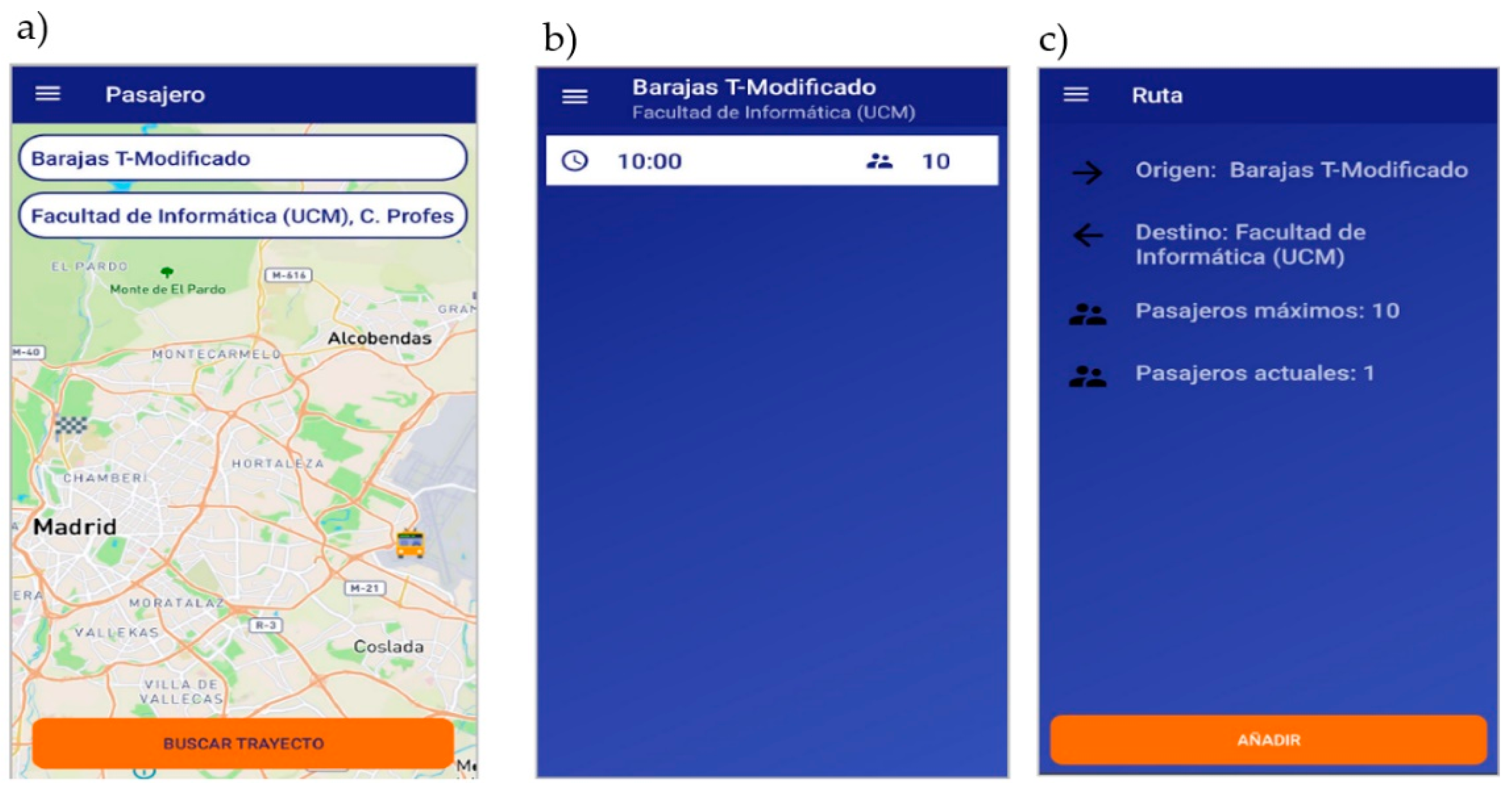
3.3. Passenger Interface
- The start link (“Inicio”), which redirects to the main interface.
- The configuration link (“Ajustes”), which allows one to configure some aspects of the application.
- The link to close session (“Cerrar Sesión”), which allows one to close the user session.
3.4. Other Interfaces
- In the main interface, the user can be authenticated by entering a username and password.
- In the registration interface, the user can create an account in the application. To do this, the user must enter an email, contact telephone number, name and surname, username and password, and type of user. It is only possible to register as a driver or passenger. The admin user type has its own username and password.
3.5. Evaluation
- Utility of the application: 13 people provided a satisfaction level of 4 points, 2 people provided 3 points, and the remaining 5 provided it with 5 points.
- Ease of use of the application: 7 people answered the question with 5 points, 8 people provided 4 points, and the remaining 5 people provided 3 points.
- Application design: 55% of the respondents rated it as “very good”, 25% rated it as “good”, and the remaining 20% viewed it as “excellent”.
- Overall evaluation: 55% of those surveyed rated it as “very good”, 30% considered it “excellent”, and the remaining 15% rated it as “good”.
4. Conclusions and Future Work
- Providing more information to the user about the trip they are taking.
- Improving the system to delimit the service area.
- Implementing a system to encrypt the personal information of users.
- Managing the payment of trips.
- Implementing forums for evaluating the service received, as well as the possibility of recommending both the service and the driver.
- Implementing a messaging system to allow communication between the passengers and the driver.
Funding
Conflicts of Interest
References
- Akabane, A.T.; Gomes, R.L.; Pazzi, R.W.; Madeira, E.R.M.; Villas, L.A. APOLO: A Mobility Pattern Analysis Approach to Improve Urban Mobility. In Proceedings of the 2017 IEEE Global Communications Conference, Singapore, 4–8 December 2017; Institute of Electrical and Electronics Engineers (IEEE): Piscataway, NJ, USA, 2017; pp. 1–6. [Google Scholar]
- Dubey, P.P.; Borkar, P. Review on techniques for traffic jam detection and congestion avoidance. In Proceedings of the 2015 2nd International Conference on Electronics and Communication Systems (ICECS), Coimbatore, India, 26–27 February 2015; Institute of Electrical and Electronics Engineers (IEEE): Piscataway, NJ, USA, 2015; pp. 434–440. [Google Scholar]
- Vencataya, L.; Pudaruth, S.; Dirpal, G.; Narain, V. Assessing the Causes & Impacts of Traffic Congestion on the Society, Economy and Individual: A Case of Mauritius as an Emerging Economy. Stud. Bus. Econ. 2018, 13, 230–242. [Google Scholar] [CrossRef]
- Marshall, W.E.; Dumbaugh, E. Revisiting the relationship between traffic congestion and the economy: A longitudinal examination of U.S. metropolitan areas. Transportation 2018, 47, 275–314. [Google Scholar] [CrossRef]
- Islam, A. A Literature Review on Freeway Traffic Incidents and Their Impact on Traffic Operations. J. Transp. Technol. 2019, 9, 504–516. [Google Scholar] [CrossRef]
- Benevolo, C.; Dameri, R.P.; D’Auria, B. Smart Mobility in Smart City. In Lecture Notes in Information Systems and Organisation; Springer Science and Business Media LLC: Berlin/Heidelberg, Germany, 2015; Volume 11, pp. 13–28. [Google Scholar]
- Nuzzolo, A.; Comi, A.; Polimeni, A. Exploring on-demand service use in large urban areas: The case of Rome. Arch. Transp. 2019, 50, 77–90. [Google Scholar] [CrossRef]
- Jayasooriya, S.; Bandara, Y. Measuring the Economic costs of traffic congestion. In Proceedings of the 2017 Moratuwa Engineering Research Conference (MERCon), Moratuwa, Sri Lanka, 29–31 May 2017; Institute of Electrical and Electronics Engineers (IEEE): Piscataway, NJ, USA, 2017; pp. 141–146. [Google Scholar]
- Jacyna, M. The urban logistic service model in the aspect of the domestic logistic system. In Urban Transport XVII: Urban Transport and the Environment in the 21st Century; IEEE: Piscataway, NJ, USA, 2011; pp. 116–117. [Google Scholar]
- Dadashova, B.; Li, X.; Turner, S.; Koeneman, P. Multivariate time series analysis of traffic congestion measures in urban areas as they relate to socioeconomic indicators. Socio-Econ. Plan. Sci. 2020, 100877. [Google Scholar] [CrossRef]
- Da Costa, D.C.T.; De Neufville, R. Designing Efficient Taxi Pickup Operations at Airports. Transp. Res. Rec. J. Transp. Res. Board 2012, 2300, 91–99. [Google Scholar] [CrossRef]
- Meneguette, R.I.; Filho, G.P.R.; Bittencourt, L.F.; Ueyama, J.; Krishnamachari, B.; Villas, L.A. Enhancing intelligence in inter-vehicle communications to detect and reduce congestion in urban centers. In Proceedings of the 2015 IEEE Symposium on Computers and Communication (ISCC), Natal, Brazil, 25–28 June 2018; Institute of Electrical and Electronics Engineers (IEEE): Piscataway, NJ, USA, 2015; pp. 1–6. [Google Scholar]
- Muller, P.J.; Sproule, W.J. Airport Parking Shuttle Comparison: Bus vs. Personal Rapid Transit. In Automated People Movers and Automated Transit Systems 2016; American Society of Civil Engineers (ASCE): Toronto, ON, Canada, 2016; pp. 63–73. [Google Scholar]
- Guo, X.; Song, R.; He, S.; Bi, M.; Jin, G. Integrated Optimization of Stop Location and Route Design for Community Shuttle Service. Symmetry 2018, 10, 678. [Google Scholar] [CrossRef]
- Liqun, L.; Chaozhong, W.; Hui, Z.; Hasan, A.H.N.; Wenhui, C.; Charles, A. Research on taxi drivers’ passenger hotspot selecting patterns based on GPS data: A case study in Wuhan. In Proceedings of the 2017 4th International Conference on Transportation Information and Safety (ICTIS), Banff, AB, Canada, 8–10 August 2017; Institute of Electrical and Electronics Engineers (IEEE): Piscataway, NJ, USA, 2017; pp. 432–441. [Google Scholar]
- Yao, B.; Cao, Q.; Jin, L.; Zhang, M.; Zhao, Y. Circle Line Optimization of Shuttle Bus in Central Business District without Transit Hub. Promet-Traffic Transp. 2017, 29, 45–55. [Google Scholar] [CrossRef]
- Ralphs, E.; Shahab, S.; Ahmadpoor, N.; Emma, R.; Sina, S.; Negar, A. Access to Small Airports and the Impact on Regional Growth in the UK. Curr. Urban Stud. 2020, 8, 24–56. [Google Scholar] [CrossRef][Green Version]
- Cao, Y.; Wang, J. The Key Contributing Factors of Customized Shuttle Bus in Rush Hour: A Case Study in Harbin City. Procedia Eng. 2016, 137, 478–486. [Google Scholar] [CrossRef]
- Xiao, Q.; He, R.; Ma, C. The analysis of urban taxi carpooling impact from taxi GPS data. Arch. Transp. 2018, 47, 109–120. [Google Scholar] [CrossRef][Green Version]
- Loi, L.T.I.; So, A.S.I.; Lo, I.S.; Fong, L.H.N. Does the quality of tourist shuttles influence revisit intention through destination image and satisfaction? The case of Macao. J. Hosp. Tour. Manag. 2017, 32, 115–123. [Google Scholar] [CrossRef]
- Liu, Y.; Jia, G.; Tao, X.; Xu, X.; Dou, W. A Stop Planning Method over Big Traffic Data for Airport Shuttle Bus. In Proceedings of the 2014 IEEE Fourth International Conference on Big Data and Cloud Computing, Sydney, Australia, 3–5 December 2014; Institute of Electrical and Electronics Engineers (IEEE): Piscataway, NJ, USA, 2014; pp. 63–70. [Google Scholar]
- Raman, V.; Gill, N.S. Review of different heuristic algorithms for solving Travelling Salesman Problem. Int. J. Adv. Res. Comput. Sci. 2017, 8, 423–425. [Google Scholar] [CrossRef]
- Laporte, G. The traveling salesman problem: An overview of exact and approximate algorithms. Eur. J. Oper. Res. 1992, 59, 231–247. [Google Scholar] [CrossRef]
- Valenzuela, C.L.; Jones, A.J. Estimating the Held-Karp lower bound for the geometric TSP. Eur. J. Oper. Res. 1997, 102, 157–175. [Google Scholar] [CrossRef]
- Wu, Y.; Song, W.; Cao, Z.; Zhang, J.; Lim, A. Learning Improvement Heuristics for Solving Routing Problems. Available online: https://arxiv.org/pdf/1912.05784.pdf (accessed on 11 September 2020).
- Nilsson, C. Heuristics for the Traveling Salesman Problem; Linkoping University: Linkoping, Sweden, 2003. [Google Scholar]
- Yazici, A.; Kamga, C.; Singhal, A. Modeling taxi drivers’ decisions for improving airport ground access: John F. Kennedy airport case. Transp. Res. Part A Policy Pract. 2016, 91, 48–60. [Google Scholar] [CrossRef]
- Yazici, M.A.; Kamga, C.; Singhal, A.; Singhal, A. A big data driven model for taxi drivers’ airport pick-up decisions in New York City. In Proceedings of the 2013 IEEE International Conference on Big Data, Santa Clara, CA, USA, 6–9 October 2013; Institute of Electrical and Electronics Engineers (IEEE): Piscataway, NJ, USA, 2013; pp. 37–44. [Google Scholar]
- Jacyna, M.; Wasiak, M.; Kłodawski, M.; Gołębiowski, P. Modelling of Bicycle Traffic in the Cities Using VISUM. Procedia Eng. 2017, 187, 435–441. [Google Scholar] [CrossRef]
- Cao, Z.; Guo, H.; Zhang, J. A Multiagent-Based Approach for Vehicle Routing by Considering Both Arriving on Time and Total Travel Time. ACM Trans. Intell. Syst. Technol. 2018, 9, 1–21. [Google Scholar] [CrossRef]
- Cao, Z.; Guo, H.; Song, W.; Gao, K.; Chen, Z.; Zhang, L.; Zhang, X. Using Reinforcement Learning to Minimize the Probability of Delay Occurrence in Transportation. IEEE Trans. Veh. Technol. 2020, 69, 2424–2436. [Google Scholar] [CrossRef]
- Cao, Z.; Wu, Y.; Rao, A.; Klanner, F.; Erschen, S.; Chen, W.; Zhang, L.; Guo, H. An Accurate Solution to the Cardinality-Based Punctuality Problem. IEEE Intell. Transp. Syst. Mag. 2018, 3, 145–160. [Google Scholar] [CrossRef]
- Cao, Z.; Guo, H.; Zhang, J.; Niyato, D.; Fastenrath, U. Finding the Shortest Path in Stochastic Vehicle Routing: A Cardinality Minimization Approach. IEEE Trans. Intell. Transp. Syst. 2015, 17, 1688–1702. [Google Scholar] [CrossRef]
- Cao, Z.; Guo, H.; Zhang, J.; Niyato, D.; Fastenrath, U. Improving the Efficiency of Stochastic Vehicle Routing: A Partial Lagrange Multiplier Method. IEEE Trans. Veh. Technol. 2015, 65, 3993–4005. [Google Scholar] [CrossRef]
- Ray, P.P. A survey on Internet of Things architectures. J. King Saud Univ.-Comput. Inf. Sci. 2018, 30, 291–319. [Google Scholar] [CrossRef]
- Lopez, J.; Rios, R.; Bao, F.; Wang, G. Evolving privacy: From sensors to the Internet of Things. Futur. Gener. Comput. Syst. 2017, 75, 46–57. [Google Scholar] [CrossRef]
- Kang, J.J.W.; Larkin, H. Inference of Personal Sensors in Internet of Things. Int. J. Inf. Commun. Technol. Appl. 2016, 2, 1–23. [Google Scholar] [CrossRef]
- Kamga, C.; Conway, A.; Singhal, A.; Yazici, A. Using Advanced Technologies to Manage Airport Taxicab Operations. J. Urban Technol. 2012, 19, 23–43. [Google Scholar] [CrossRef]
- Li, Y.; Lu, J.; Zhang, L.; Zhao, Y. Taxi Booking Mobile App Order Demand Prediction Based on Short-Term Traffic Forecasting. Transp. Res. Rec. J. Transp. Res. Board 2017, 2634, 57–68. [Google Scholar] [CrossRef]
- Chuah, S.P.; Wu, H.; Lu, Y.; Yu, L.; Bressan, S. Bus Routes Design and Optimization via Taxi Data Analytics. In Proceedings of the 25th ACM International on Conference on Information and Knowledge Management, Indianapolis, IN, USA, 24–28 October 2016; pp. 2417–2420. [Google Scholar]
- Gibson, R.; Erle, S. Google Maps Hacks; O’Reilly Media, Inc.: New York, NY, USA, 2006; pp. 25–45. [Google Scholar]
- Kastanakis, B. Mapbox Cookbook; Packt Publishing Ltd.: Birmingham, UK, 2016; pp. 61–72. [Google Scholar]
- Bennett, J. OpenStreetMap; Packt Publishing Ltd.: Birmingham, UK, 2016; pp. 45–68. [Google Scholar]
- Mapsme. Available online: https://maps.me (accessed on 17 August 2020).
- Navmii. Available online: https://www.navmii.com/ (accessed on 17 August 2020).
- Waze. Available online: https://www.waze.com (accessed on 17 August 2020).
- HereWeGo. Available online: https://here.com/app (accessed on 17 August 2020).
- Map3D pro. Available online: https://www.map3d.com/ (accessed on 17 August 2020).
- Navarro, N.A.G. Vehicle rental with driver (VTC) and its legal implications. Uber, Cabify and the colaborative economy. Rev. Estud. Adm. Local Autonómica 2018, 9, 128–140. [Google Scholar]
- Uber. Available online: https://www.uber.com (accessed on 17 August 2020).
- Cabify. Available online: https://cabify.com (accessed on 17 August 2020).
- MyTaxi. Available online: https://free-now.com/ (accessed on 17 August 2020).
- Rayle, L.; Shaheen, S.A.; Chan, N.; Dai, D.; Cervero, R. App-Based, on-Demand Ride Services: Comparing Taxi and Ridesourcing Trips and User Characteristics in San Francisco (No. UCTC-FR-2014-08); University of California Transportation Center: Berkeley, CA, USA, 2014. [Google Scholar]
- Yang, Z.; Wu, C.; Zhou, Z.; Zhang, X.; Wang, X.; Liu, Y. Mobility Increases Localizability. ACM Comput. Surv. 2015, 47, 1–34. [Google Scholar] [CrossRef]
- Jain, A.; Kanhangad, V. Human Activity Classification in Smartphones Using Accelerometer and Gyroscope Sensors. IEEE Sens. J. 2018, 18, 1169–1177. [Google Scholar] [CrossRef]
- Al-Turjman, F. Impact of user’s habits on smartphones’ sensors: An overview. In 2016 HONET-ICT; IEEE: Piscataway, NJ, USA, 2016; pp. 70–74. [Google Scholar]
- Li, F.; Zhao, C.; Ding, G.; Gong, J.; Liu, C. A Reliable and Accurate Indoor Localization Method Using Phone Inertial Sensors. In Proceedings of the 2012 ACM Conference on Computer and Communications Security—CCS ’12, New York, NY, USA, 5–8 September 2012; p. 421. [Google Scholar]
- Deng, Z.-A.; Hu, Y.; Yu, J.; Na, Z. Extended Kalman Filter for Real Time Indoor Localization by Fusing WiFi and Smartphone Inertial Sensors. Micromachines 2015, 6, 523–543. [Google Scholar] [CrossRef]
- Liu, Y.; Dashti, M.; Rahman, M.A.A.; Zhang, J. Indoor localization using smartphone inertial sensors. In Proceedings of the 2014 11th Workshop on Positioning, Navigation and Communication (WPNC), Dresden, Germany, 11–12 March 2010; IEEE: Piscataway, NJ, USA, 2014; pp. 1–6. [Google Scholar]
- Milette, G.; Stroud, A. Professional Android Sensor Programming; John Wiley & Sons: Hoboken, NJ, USA, 2012; pp. 87–98. [Google Scholar]
- Zhi-An, Y.; Chun-Miao, M. The development and application of sensor based on android. In Proceedings of the 2012 8th International Conference on Information Science and Digital Content Technology (ICIDT2012), Jeju, Korea, 26–28 June 2012; IEEE: Piscataway, NJ, USA, 2012; pp. 231–234. [Google Scholar]
- Gurram, B.; Giri, N. Improving localization accuracy of android’s Fused Location Provider API using Kalman Filter. In Proceedings of the 2016 International Conference on Computer Communication and Informatics (ICCCI), Coimbatore, India, 7–9 January 2016; IEEE: Piscataway, NJ, USA, 2016; pp. 1–4. [Google Scholar]
- van Rees, E. DigitalGlobe and big data. GeoInformatics 2016, 19, 6. [Google Scholar]
- Saputra, K.; Furqan, M.; Abidin, T.F.; Yunadi, D.H. Google maps and mapbox api performance analysis on android-based lecture attendance application. J. Nat. 2019, 19, 64–68. [Google Scholar] [CrossRef]


| Product | License | Use | Updates | Advertising | Online | Accuracy |
|---|---|---|---|---|---|---|
| Google Maps | Proprietary | Free | Fast | Yes | Yes | Very precise |
| MapBox | Open | Free | Fast | No | Yes | Very precise |
| OpenStreetMaps | Open | Free | Fast | No | Yes | Very precise |
| Maps.me | Open | Free | Fast | No | No | Not precise |
| Navmii | Open | Free | Slow | No | Yes | Precise |
| Waze | Proprietary | Free | Fast | Yes | Yes | Precise |
| HereWeGo | Proprietary | Free | Slow | No | Yes | Precise |
| MAP3D pro | Proprietary | Not free | Fast | Yes | Yes | Precise |
| Parameter | Description |
|---|---|
| annotations | Return additional metadata along the route. It must include several annotations as a comma-separated list. The possible values are duration (the duration between each pair of coordinates in seconds), distance (the distance between each pair of coordinates in meters), and speed (the speed between each pair of coordinates in meters per second). It requires that the parameter overview = full |
| approaches | A semicolon-separated list indicating the side of the road from which to approach the waypoints on a requested route. Accepts unrestricted (default, where the route can arrive at the waypoint from either side of the road) or curb data (the route will arrive at the waypoint on the driving_side of the region). If provided, the number of approaches must be the same as the number of waypoints. However, it can skip a coordinate and show its position in the list with the “;” separator. It must be used in combination with steps = true. |
| bearings | It influences the direction in which a route starts from a waypoint and is used to filter the road segment on which a waypoint will be placed by direction. This is useful for ensuring that rerouted vehicles continue traveling in their current direction. A request that does this will provide the bearing and radius values for the first waypoint and leave the remaining values empty. It must be used in conjunction with the radiuses parameter and takes 2 values per waypoint: an angle clockwise from true north between 0 and 360 and the range of degrees by which the angle can deviate (the recommended value is 45° or 90°), formatted as {angle, degrees}. If provided, the list of bearings must be the same length as the list of waypoints. However, one can skip a coordinate and show its position in the list with the “;” separator. |
| destination | It specifies the destination coordinate of the returned route and accepts any (default) or the last parameters. |
| distributions | It specifies the pick-up and drop-off locations for a trip by providing a delimited list of numbered pairs that correspond to the coordinate list. The first number of a pair indicates the index for the coordinate of the pick-up location in the coordinate list, and the second number indicates the index for the coordinate of the drop-off location in the coordinate list. Each pair must contain exactly 2 numbers, which cannot be the same. The returned solution will visit the pick-up locations before visiting the drop-off locations. The first location can only be a pick-up location, not a drop-off location. |
| geometries | The format of the returned geometry. The allowed values are geojson (as LineString), polyline (default, a polyline with precision 5), and polyline6 (a polyline with precision 6). |
| language | The language of the returned turn-by-turn text instructions. The default is en (English). |
| Overview | The type of the returned overview geometry. It can be full (the most detailed geometry available), simplified (default, a simplified version of the full geometry), or false (no overview geometry). |
| Radiuses | The maximum distance a coordinate can be moved to snap to the road network in meters. There must be as many radiuses as there are coordinates in the request, each separated by “;”. Values can be any number greater than 0 or an unlimited string. A NoSegment error is returned if no routable road is found within the radius. |
| source | The coordinate at which to start the returned route. Accepts any (default) or first parameters. |
| steps | Determines whether to return the steps and turn-by-turn instructions (true) or not (false, default). |
| roundtrip | Indicates whether the returned route is a roundtrip, meaning that the route returns to the first location (true, default) or not (false). If roundtrip = false, the source and destination parameters are required, but not all combinations will be possible. |
© 2020 by the author. Licensee MDPI, Basel, Switzerland. This article is an open access article distributed under the terms and conditions of the Creative Commons Attribution (CC BY) license (http://creativecommons.org/licenses/by/4.0/).
Share and Cite
Sarasa-Cabezuelo, A. The Use of Geolocation to Manage Passenger Mobility between Airports and Cities. Computers 2020, 9, 73. https://doi.org/10.3390/computers9030073
Sarasa-Cabezuelo A. The Use of Geolocation to Manage Passenger Mobility between Airports and Cities. Computers. 2020; 9(3):73. https://doi.org/10.3390/computers9030073
Chicago/Turabian StyleSarasa-Cabezuelo, Antonio. 2020. "The Use of Geolocation to Manage Passenger Mobility between Airports and Cities" Computers 9, no. 3: 73. https://doi.org/10.3390/computers9030073
APA StyleSarasa-Cabezuelo, A. (2020). The Use of Geolocation to Manage Passenger Mobility between Airports and Cities. Computers, 9(3), 73. https://doi.org/10.3390/computers9030073