A Multi-Constraint Combined Method for Ground Surface Point Filtering from Mobile LiDAR Point Clouds


Abstract
:
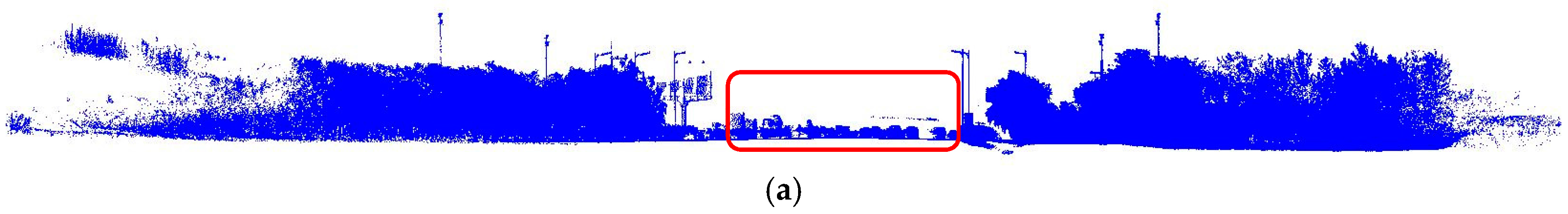
1. Introduction
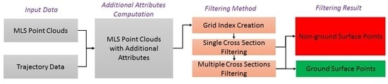
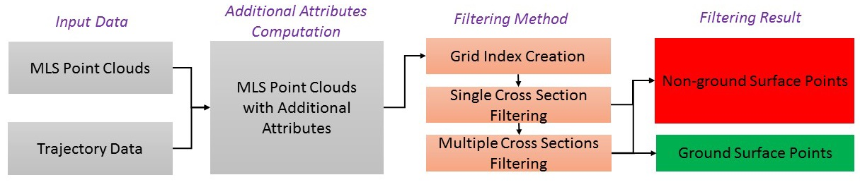
2. Materials and Methods
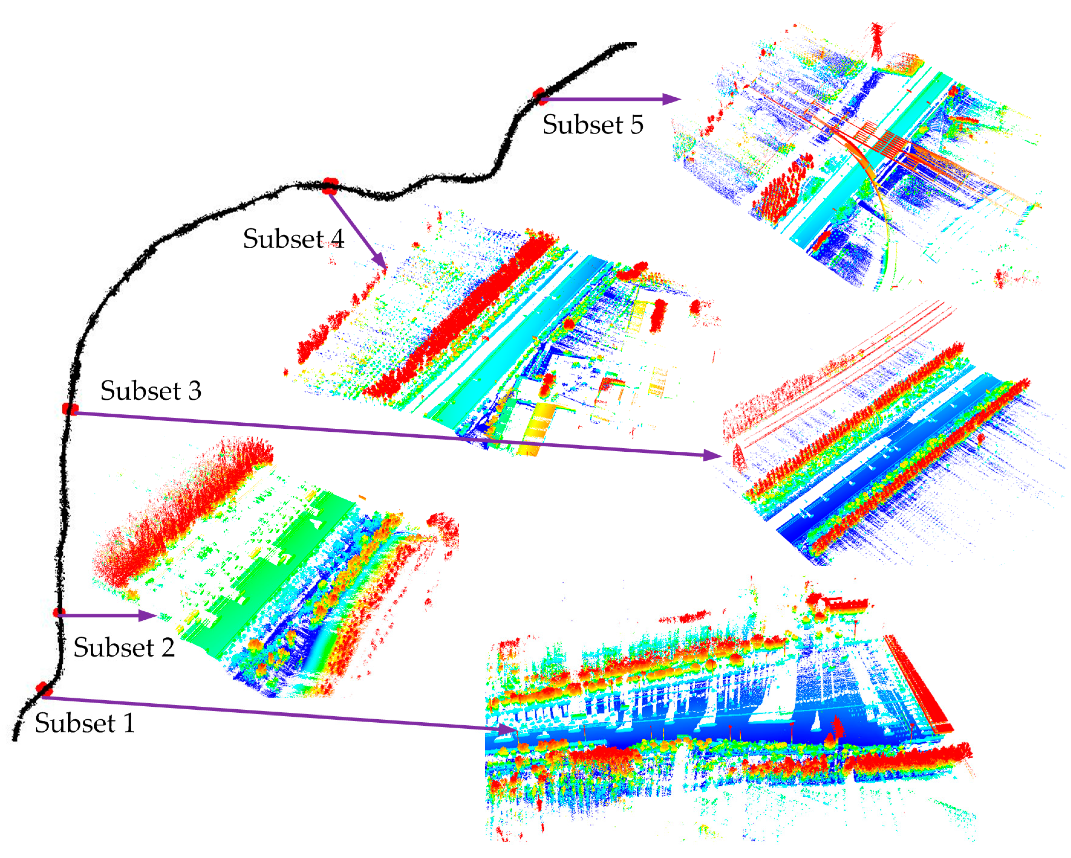
2.1. MLS Datasets
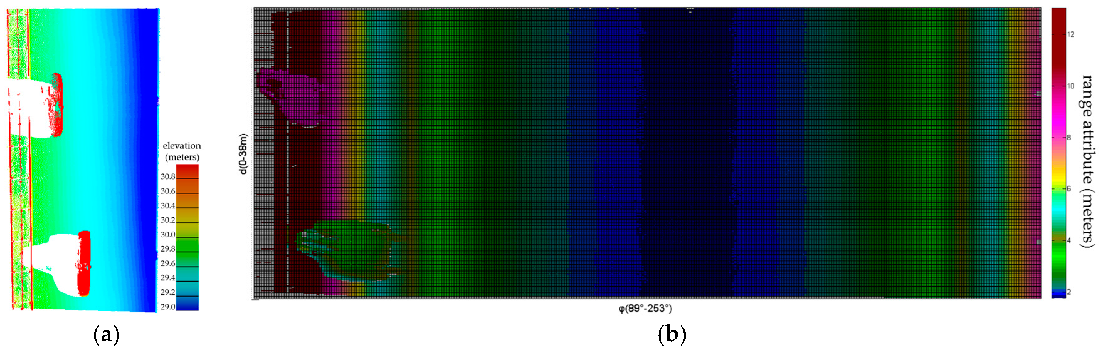
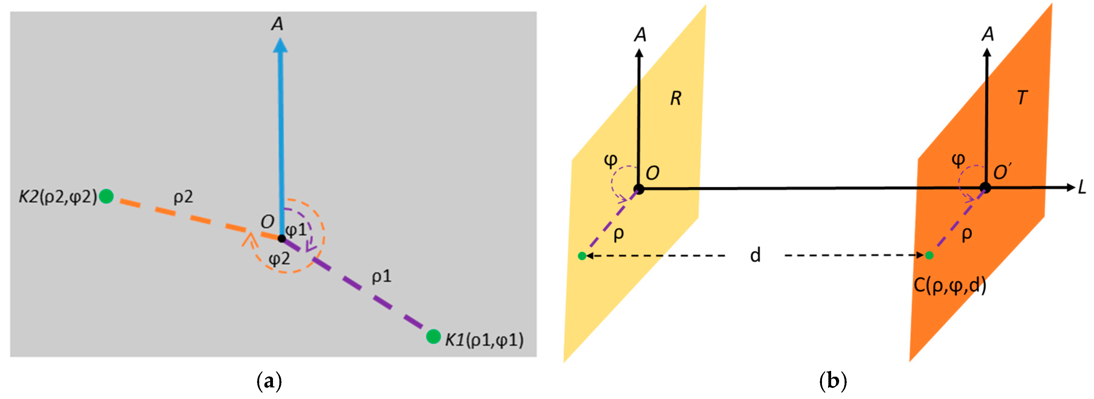
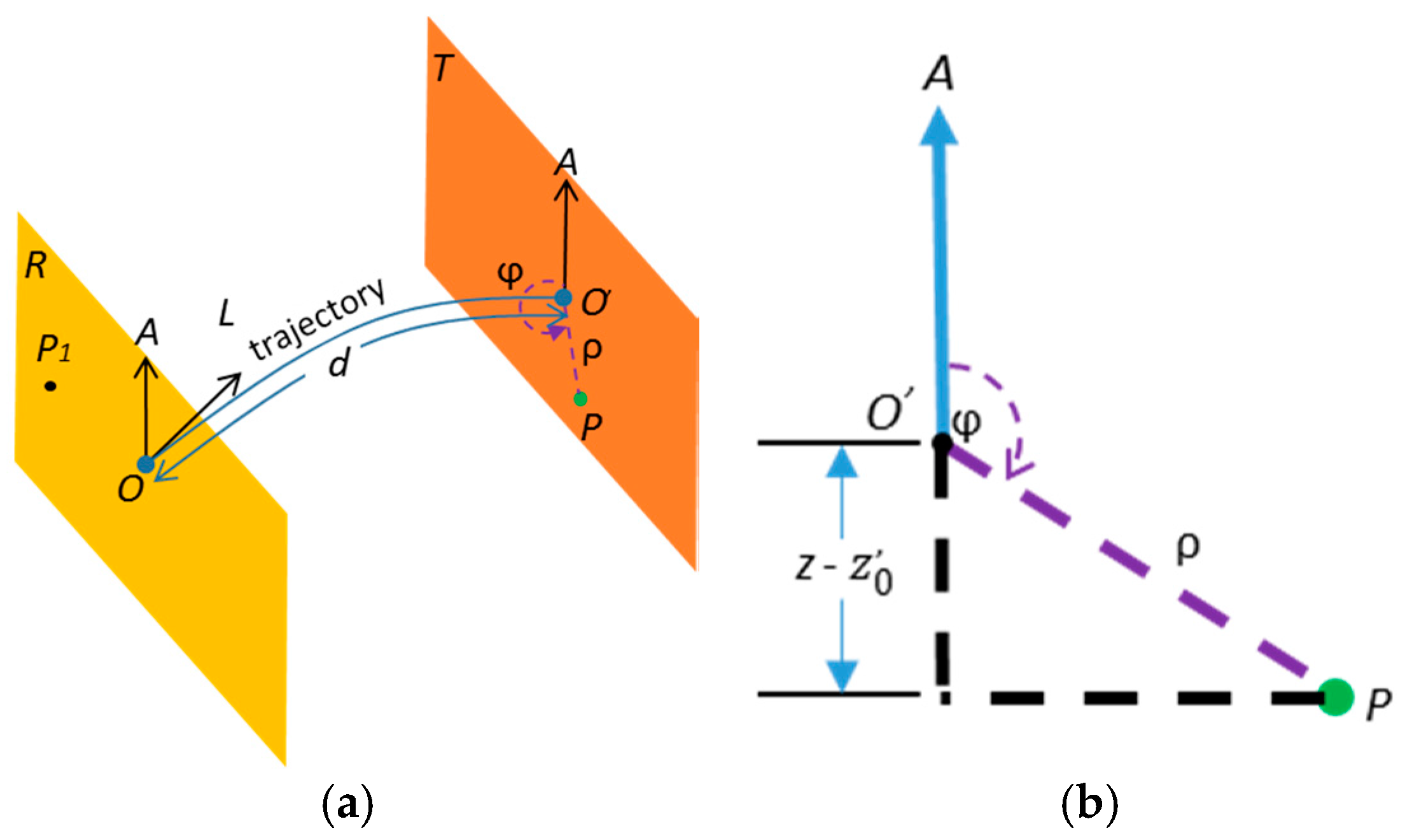
2.2. Computation of MLS Point Cloud Attributes
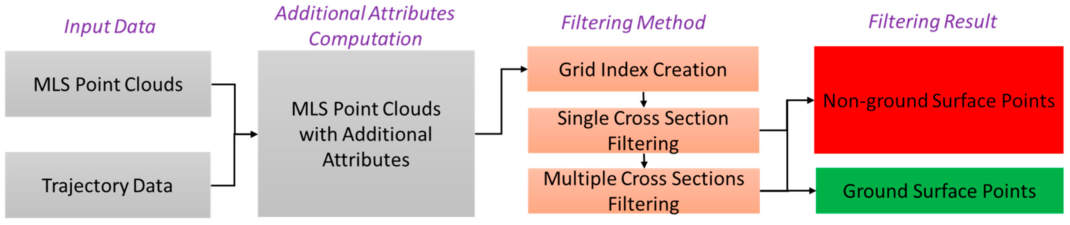
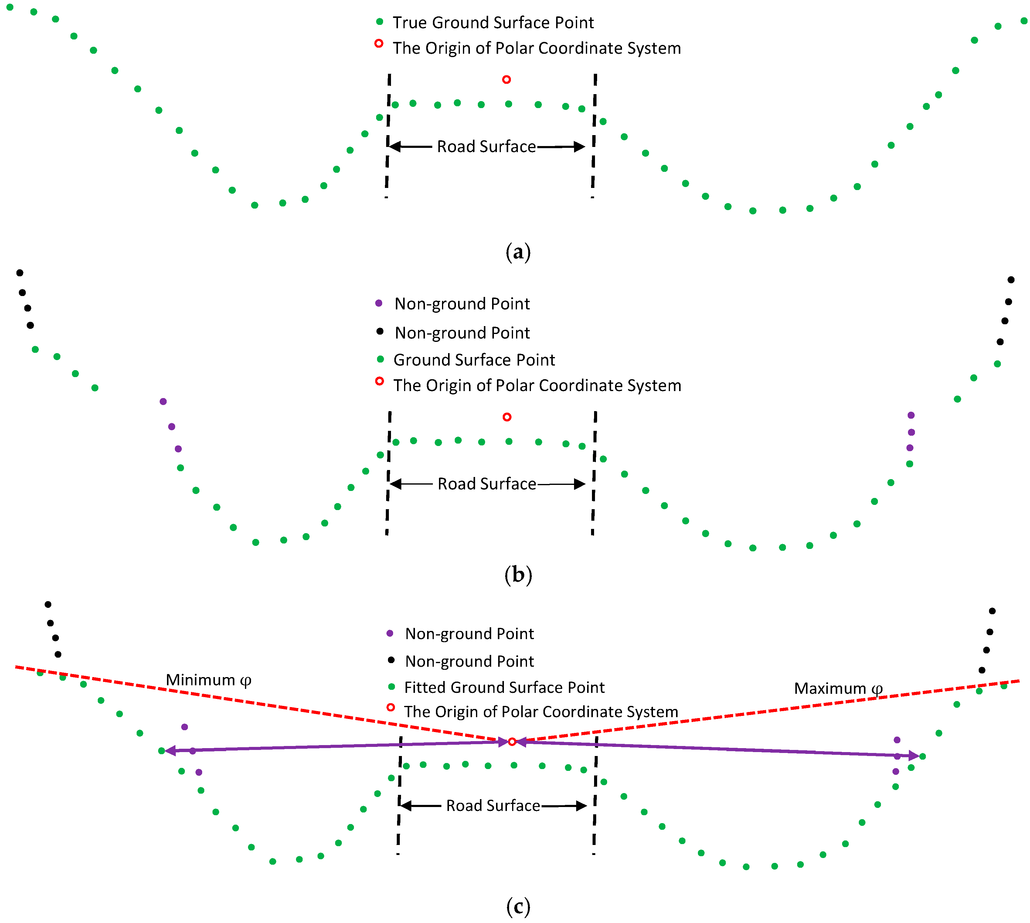
2.3. Filtering Method
2.3.1. Grid Construction
- Finding the minimum angular position and the minimum longitudinal distance .
- Determining the angular resolution and distance resolution .
- Assigning the MLS point to the grid cell with row index and column index computed using Equations (3) and (4). If more than one point is assigned to the same grid index, the point with largest range attribute is preserved.
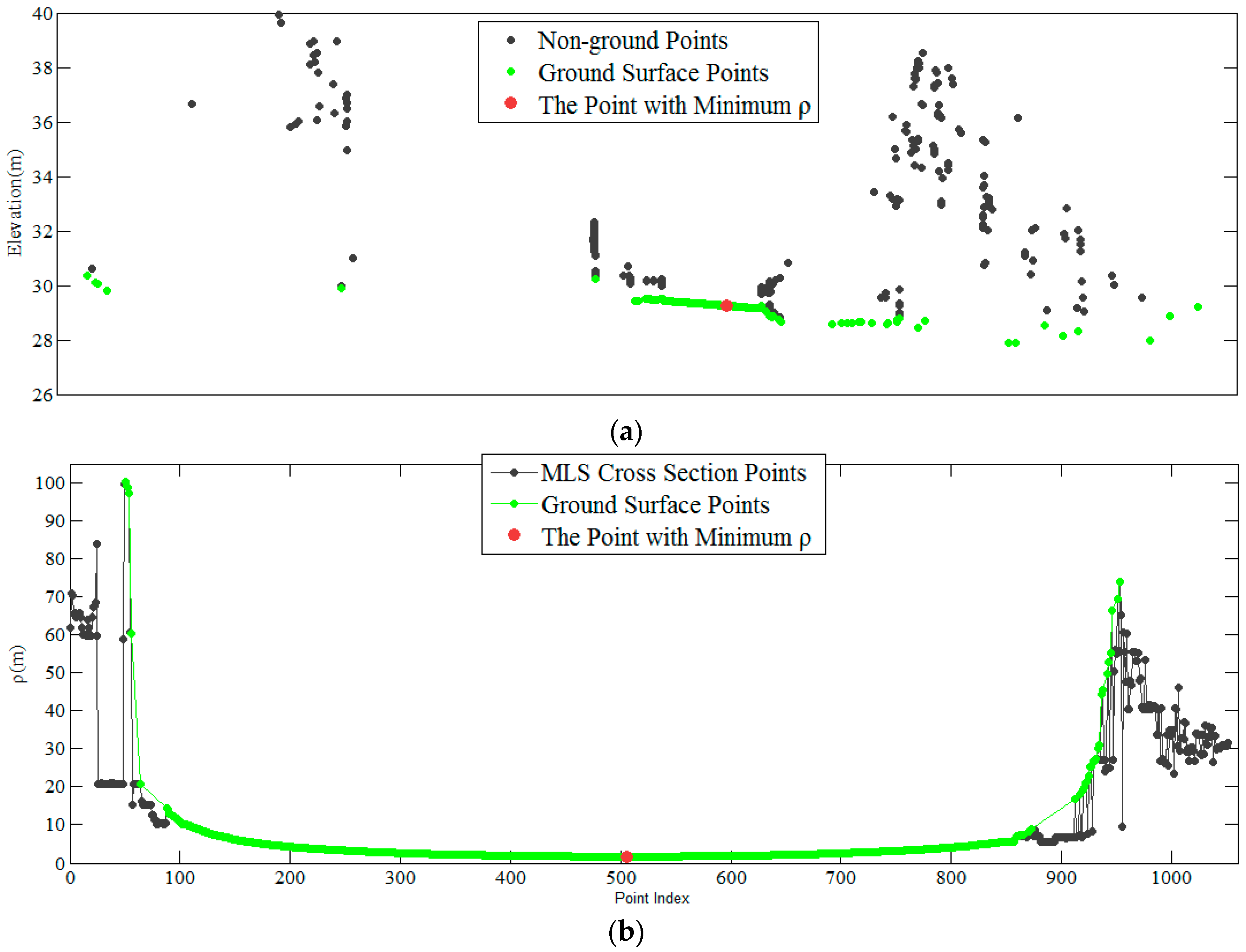
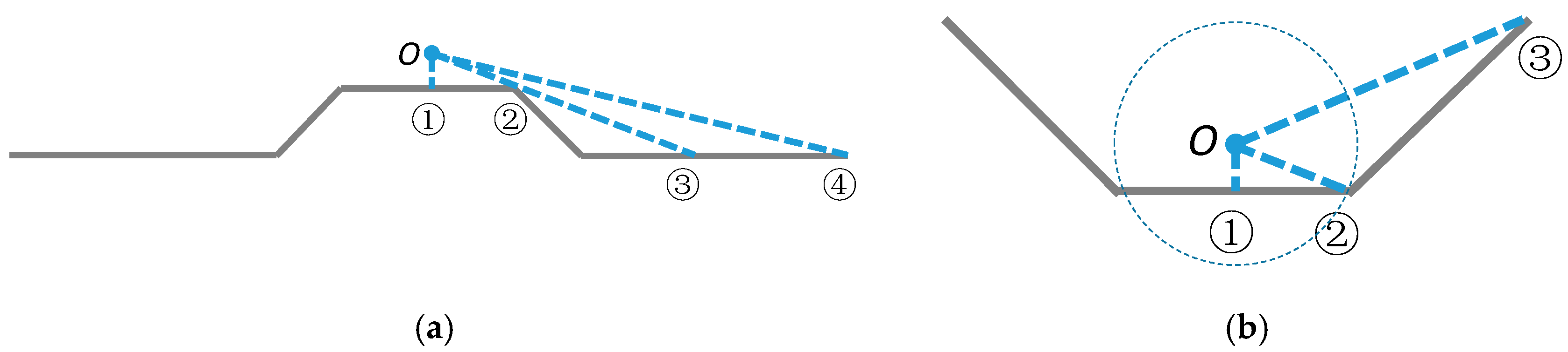
2.3.2. Single Cross-Section Filtering (SCSF)
2.3.3. Multiple Cross-Section Filtering (MCSF)
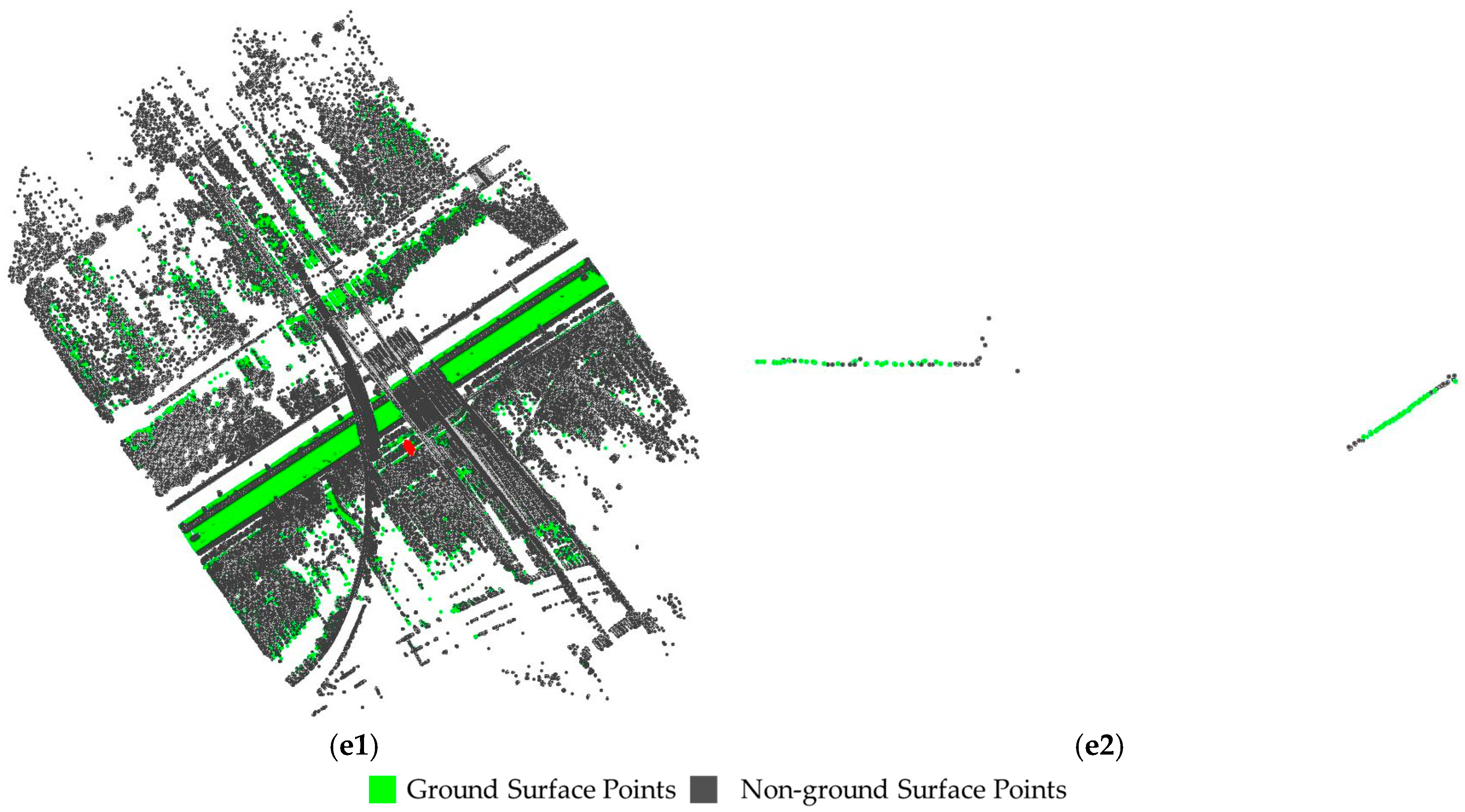
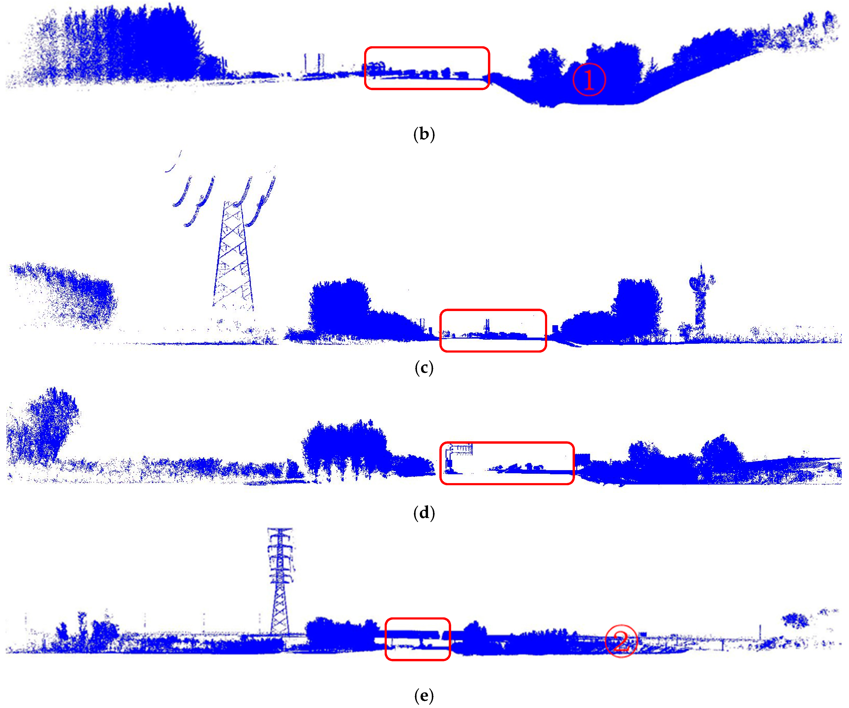
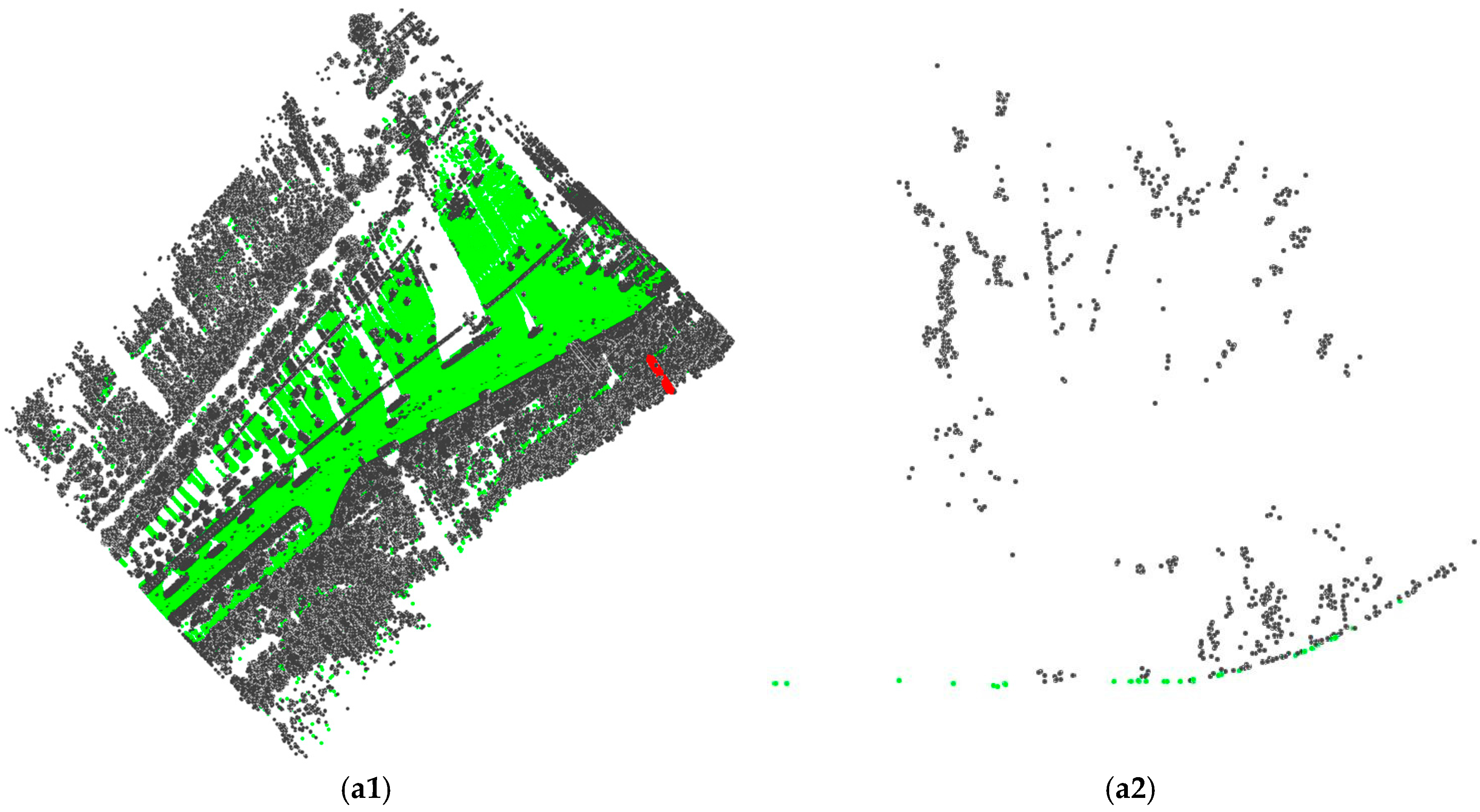
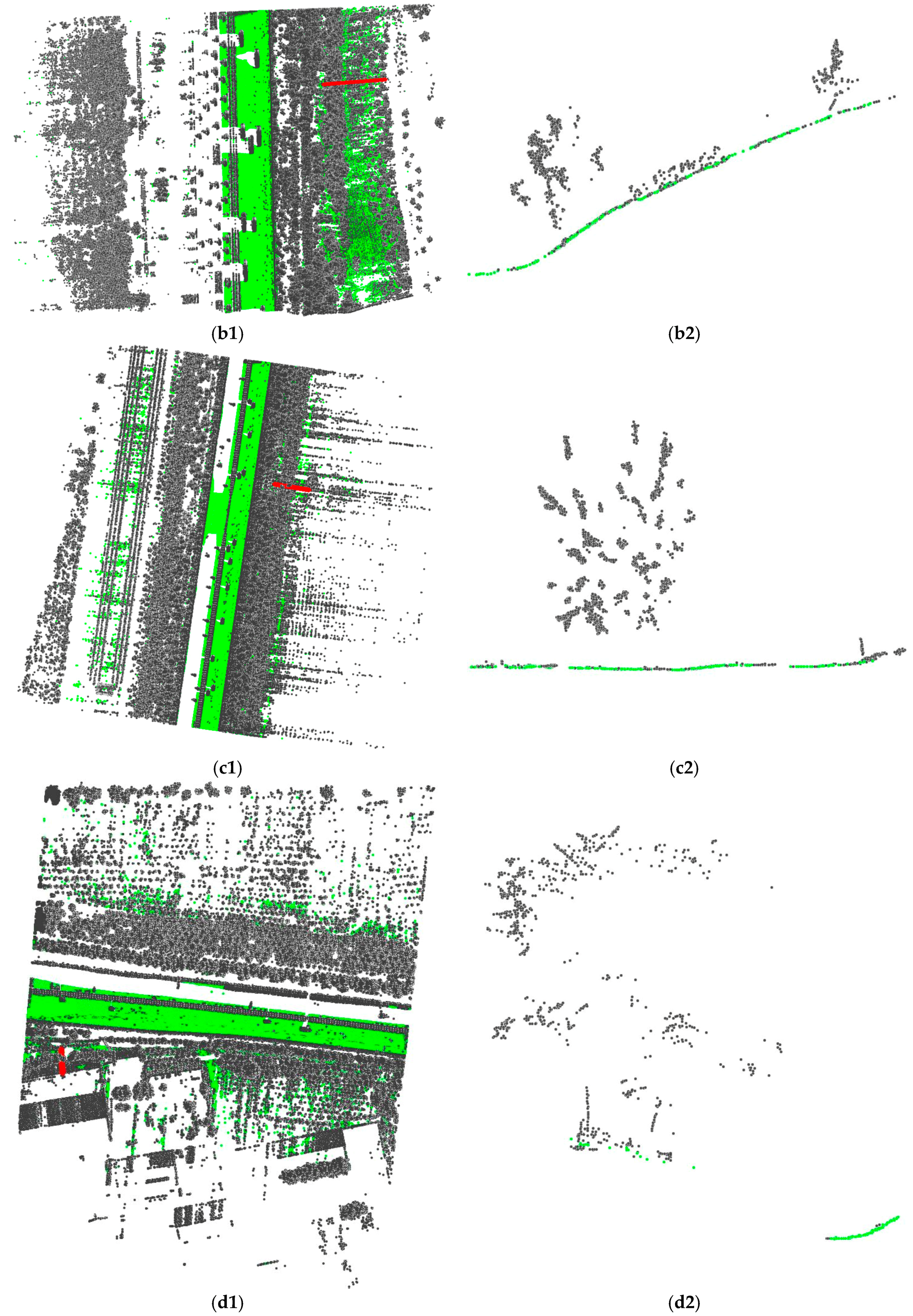
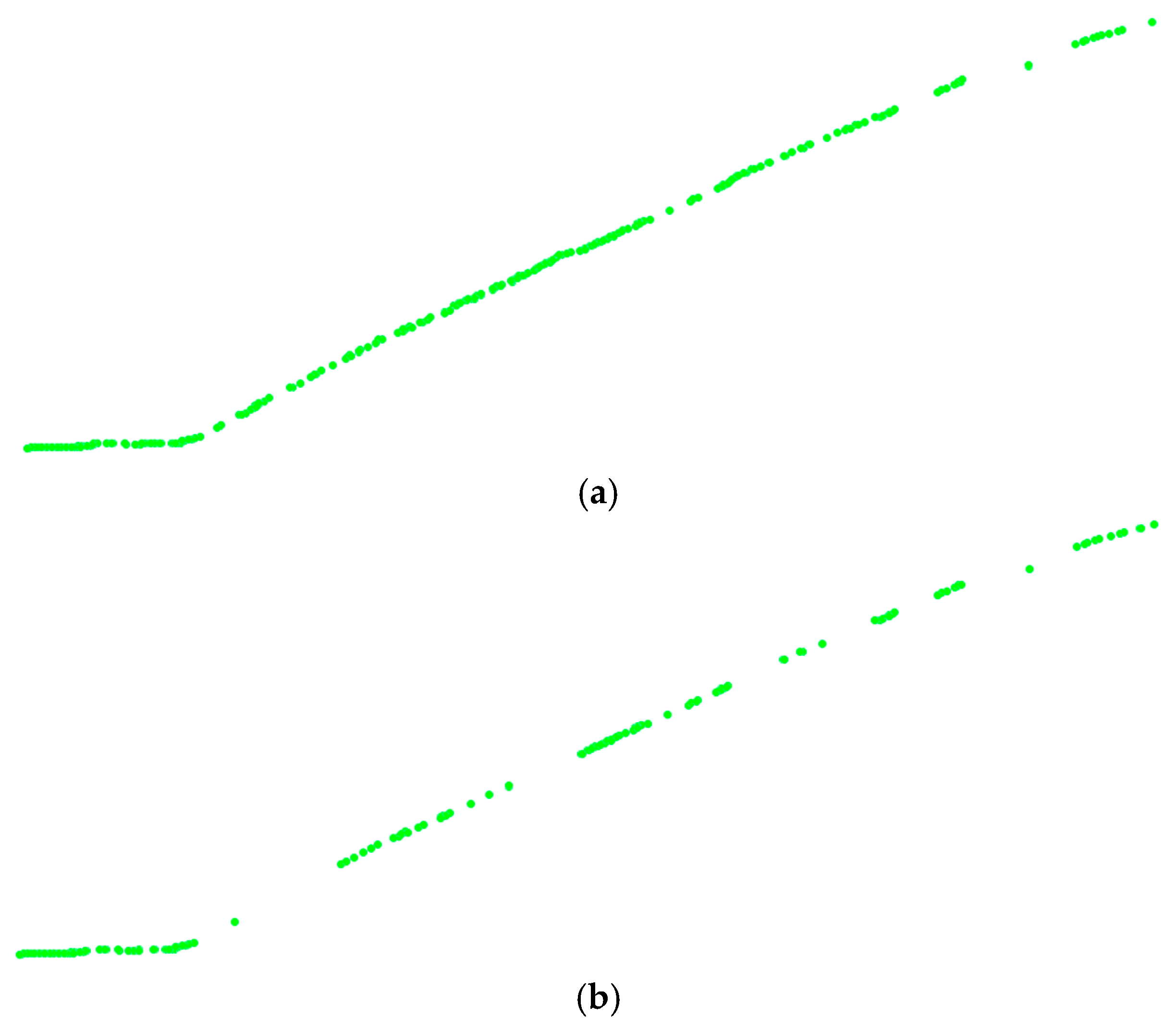
3. Results
4. Discussion
4.1. Accuracy
4.2. Parameter Setting
4.3. THE Combination of Multiple Filtering Methods
5. Conclusions
Acknowledgments
Author Contributions
Conflicts of Interest
References
- Holgado-Barco, A.; Gonzalez-Aguilera, D.; Arias-Sanchez, P.; Martinez-Sanchez, J. An automated approach to vertical road characterisation using mobile LiDAR systems: Longitudinal profiles and cross-sections. ISPRS. J. Photogramm. Remote Sens. 2014, 96, 28–37. [Google Scholar] [CrossRef]
- Puente, I.; Akinci, B.; González-Jorge, H.; Díaz-Vilariño, L.; Arias, P. A semi-automated method for extracting vertical clearance and cross sections in tunnels using mobile LiDAR data. Tunn. Undergr. Space Technol. 2016, 59, 48–54. [Google Scholar] [CrossRef]
- Guan, H.; Li, J.; Cao, S.; Yu, Y. Use of mobile LiDAR in road information inventory: A review. Int. J. Image Data Fusion 2016, 7, 219–242. [Google Scholar] [CrossRef]
- Vosselman, G. Slope Based Filtering of Laser Altimetry Data. Int. Arch. Photogramm. Remote Sens. 2000, 33, 935–942. [Google Scholar]
- Sithole, G. Filtering of laser altimetry data using slope adaptive filter. Int. Arch. Photogramm. Remote Sens. Spat. Inf. Sci. 2001, 34, 203–210. [Google Scholar]
- Roggero, M. Airborne Laser Scanning-Clustering in Raw Data. Int. Arch. Photogramm. Remote Sens. Spat. Inf. Sci. 2001, 34, 227–232. [Google Scholar]
- Kilian, J.; Haala, N.; Englich, M. Capture and Evaluation of Airborne Laser Scanner Data. Int. Arch. Photogramm. Remote Sens. 1996, 31, 383–388. [Google Scholar]
- Zhang, K.; Chen, S.C.; Whitman, D.; Shyu, M.L. A progressive morphological filter for removing nonground measurements from airborne LIDAR data. IEEE Trans. Geosci. Remote Sens. 2003, 41, 872–882. [Google Scholar] [CrossRef]
- Chen, Q.; Gong, P.; Baldocchi, D.; Xie, G. Filtering Airborne Laser Scanning Data with Morphological Methods. Photogramm. Eng. Remote Sens. 2007, 2, 175–185. [Google Scholar] [CrossRef]
- Pingel, T.J.; Clarke, K.C.; McBride, W.A. An improved simple morphological filter for the terrain classification of airborne LIDAR data. ISPRS J. Photogramm. Remote Sens. 2013, 77, 21–30. [Google Scholar] [CrossRef]
- Mongus, D.; Lukač, N.; Žalik, B. Ground and building extraction from LiDAR data based on differential morphological profiles and locally fitted surfaces. ISPRS J. Photogramm. Remote Sens. 2014, 93, 145–156. [Google Scholar] [CrossRef]
- Kraus, K.; Pfeifer, N. Determination of terrain models in wooded areas with airborne laser scanner data. ISPRS J. Photogramm. Remote Sens. 1998, 53, 193–203. [Google Scholar] [CrossRef]
- Pfeifer, N.; Reiter, T.; Briese, C.; Rieger, W. Interpolation of high quality ground models from laser scanner data in forested areas. Int. Arch. Photogramm. Remote Sens. 1999, 32, 31–36. [Google Scholar]
- Elmqvist, M. Ground Surface Estimation from Airborne Laser Scanner Data Using Active Shape Models. Int. Arch. Photogramm. Remote Sens. Spat. Inf. Sci. 2002, 34, 114–118. [Google Scholar]
- Elmqvist, M.; Jungert, E.; Lantz, F.; Persson, Å.; Söderman, U. Terrain modelling and analysis using laser scanner data. Int. Arch. Photogramm. Remote Sens. Spat. Inf. Sci. 2001, 34, 22–24. [Google Scholar]
- Zhang, W.; Qi, J.; Wan, P.; Wang, H.; Xie, D.; Wang, X.; Yan, G. An Easy-to-Use Airborne LiDAR Data Filtering Method Based on Cloth Simulation. Remote Sens. 2016, 8, 501. [Google Scholar] [CrossRef]
- Hu, H.; Ding, Y.; Zhu, Q.; Wu, B.; Lin, H.; Du, Z.; Zhang, Y.; Zhang, Y. An adaptive surface filter for airborne laser scanning point clouds by means of regularization and bending energy. ISPRS J. Photogramm. Remote Sens. 2014, 92, 98–111. [Google Scholar] [CrossRef]
- Axelsson, P. Processing of laser scanner data-algorithms and applications. ISPRS J. Photogramm. Remote Sens. 1999, 54, 138–147. [Google Scholar] [CrossRef]
- Sohn, G.; Dowman, I. Terrain surface reconstruction by the use of tetrahedron model with the MDL criterion. Int. Arch. Photogramm. Remote Sens. Spat. Inf. Sci. 2002, 34, 336–344. [Google Scholar]
- Zhang, J.; Lin, X. Filtering airborne LiDAR data by embedding smoothness-constrained segmentation in progressive TIN densification. ISPRS J. Photogramm. Remote Sens. 2013, 81, 44–59. [Google Scholar] [CrossRef]
- Zhao, X.; Guo, Q.; Su, Y.; Xue, B. Improved progressive TIN densification filtering algorithm for airborne LiDAR data in forested areas. ISPRS J. Photogramm. Remote Sens. 2016, 117, 79–91. [Google Scholar] [CrossRef]
- Brovelli, M.A.; Cannata, M.; Longoni, U.M. LIDAR Data Filtering and DTM Interpolation Within GRASS. Trans. GIS 2004, 8, 155–174. [Google Scholar] [CrossRef]
- Brovelli, M.A.; Cannata, M.; Longoni, U.M. Managing and processing LIDAR data within GRASS. In Proceedings of the GRASS Users Conference, Trento, Italy, 11–13 September 2002; Volume 29. [Google Scholar]
- Tóvári, D.; Pfeifer, N. Segmentation based robust interpolation-a new approach to laser data filtering. Int. Arch. Photogramm. Remote Sens. Spat. Inf. Sci. 2005, 36, 79–84. [Google Scholar]
- Cahalane, C.; McElhinney, C.; Lewis, P.; McCarthy, T. Calculation of Target-Specific Point Distribution for 2D Mobile Laser Scanners. Sensors 2014, 14, 9471–9488. [Google Scholar] [CrossRef] [PubMed]
- Cahalane, C.; McElhinney, C.; Lewis, P.; McCarthy, T. MIMIC: An Innovative Methodology for Determining Mobile Laser Scanning System Point Density. Remote Sens. 2014, 6, 7857–7877. [Google Scholar]
- Wu, B.; Yu, B.; Huang, C.; Wu, Q.; Wu, J. Automated extraction of ground surface along urban roads from mobile laser scanning point clouds. Remote Sens. Lett. 2016, 7, 170–179. [Google Scholar] [CrossRef]
- Nurunnabi, A.; West, G.; Belton, D. Robust Locally Weighted Regression Techniques for Ground Surface Points Filtering in Mobile Laser Scanning Three Dimensional Point Cloud Data. IEEE Trans. Geosci. Remote Sens. 2016, 54, 2181–2193. [Google Scholar] [CrossRef]
- Zhou, Y.; Wang, D.; Xie, X.; Ren, Y. A Fast and Accurate Segmentation Method for Ordered LiDAR Point Cloud of Large-Scale Scenes. IEEE Geosci. Remote Sens. Lett. 2014, 11, 1981–1985. [Google Scholar] [CrossRef]
- Guan, H.; Li, J.; Yu, Y.; Wang, C.; Chapman, M.; Yang, B. Using mobile laser scanning data for automated extraction of road markings. ISPRS J. Photogramm. Remote Sens. 2014, 87, 93–107. [Google Scholar] [CrossRef]
- Zheng, H.; Wang, R.; Xu, S. Recognizing Street Lighting Poles From Mobile LiDAR Data. IEEE Trans. Geosci. Remote Sens. 2017, 55, 407–420. [Google Scholar] [CrossRef]
- Yang, B.; Dong, Z. A shape-based segmentation method for mobile laser scanning point clouds. ISPRS J. Photogramm. Remote Sens. 2013, 81, 19–30. [Google Scholar] [CrossRef]
- Luo, H.; Wang, C.; Wen, C.; Cai, Z.; Chen, Z.; Wang, H.; Yu, Y.; Li, J. Patch-Based Semantic Labeling of Road Scene Using Colorized Mobile LiDAR Point Clouds. IEEE Trans. Intell. Transp. Syst. 2016, 17, 1286–1297. [Google Scholar] [CrossRef]
- Stover, C.; Weisstein, E.W. Polar Coordinates. From MathWorld-A Wolfram Web Resource. Available online: http://mathworld.wolfram.com/PolarCoordinates.html (accessed on 3 September 2017).
- Weisstein, E.W. Cylindrical coordinates. In CRC Concise Encyclopedia of Mathematics, 2nd ed.; CRC Press: Boca Raton, FL, USA, 2002; p. 653. [Google Scholar]
- Sithole, G.; Vosselman, G. Experimental comparison of filter algorithms for bare-Earth extraction from airborne laser scanning point clouds. ISPRS J. Photogramm. Remote Sens. 2004, 59, 85–101. [Google Scholar] [CrossRef]
- Yang, B.; Huang, R.; Dong, Z.; Zang, Y.; Li, J. Two-step adaptive extraction method for ground points and breaklines from lidar point clouds. ISPRS J. Photogramm. Remote Sens. 2016, 119, 373–389. [Google Scholar] [CrossRef]


| Dataset | Length (m) | Number of Points (million) | Ground Surface Type | Typical Non-Ground Objects |
|---|---|---|---|---|
| Subset 1 | 295 | 14.2 | Flat Gentle | Large numbers of trees Large numbers of cars Lamps, buildings |
| Subset 2 | 140 | 4.7 | Flat Steep | Large numbers of trees Large numbers of cars Power lines |
| Subset 3 | 290 | 9.3 | Flat Gentle | Large number of trees Cars, power lines |
| Subset 4 | 270 | 9.6 | Flat Gentle | Large numbers of trees Cars, buildings |
| Subset 5 | 320 | 9.6 | Flat Steep | Trees, power lines Cars, overpass road |
| Dataset | Type I Error | Type II Error | Total Error | ||||||
|---|---|---|---|---|---|---|---|---|---|
| CSF | PMF | Proposed Method | CSF | PMF | Proposed Method | CSF | PMF | Proposed Method | |
| Subset 1 | 7.745% | 0.872% | 0.790% | 1.800% | 2.172% | 0.830% | 5.939% | 1.267% | 0.802% |
| Subset 2 | 12.077% | 3.318% | 1.872% | 1.133% | 2.811% | 3.741% | 7.160% | 3.090% | 2.712% |
| Subset 3 | 3.252% | 1.270% | 1.470% | 2.108% | 2.699% | 1.382% | 2.801% | 1.833% | 1.435% |
| Subset 4 | 1.996% | 0.470% | 1.253% | 2.104% | 3.300% | 1.266% | 2.027% | 1.283% | 1.256% |
| Subset 5 | 14.606% | 2.342% | 1.743% | 1.831% | 2.566% | 2.204% | 10.155% | 2.420% | 1.904% |
| Average | 7.935% | 1.654% | 1.426% | 1.795% | 2.710% | 1.885% | 5.616% | 1.979% | 1.622% |
| Dataset | Attribute Computation (s) | Filtering (s) | Total (s) |
|---|---|---|---|
| Subset 1 | 1308.5 | 227.5 | 1536.0 |
| Subset 2 | 278.0 | 30.7 | 308.7 |
| Subset 3 | 729.3 | 95.1 | 824.4 |
| Subset 4 | 882.9 | 106.6 | 989.5 |
| Subset 5 | 817.1 | 145.4 | 962.5 |
© 2017 by the authors. Licensee MDPI, Basel, Switzerland. This article is an open access article distributed under the terms and conditions of the Creative Commons Attribution (CC BY) license (http://creativecommons.org/licenses/by/4.0/).
Share and Cite
Yan, L.; Liu, H.; Tan, J.; Li, Z.; Chen, C. A Multi-Constraint Combined Method for Ground Surface Point Filtering from Mobile LiDAR Point Clouds. Remote Sens. 2017, 9, 958. https://doi.org/10.3390/rs9090958
Yan L, Liu H, Tan J, Li Z, Chen C. A Multi-Constraint Combined Method for Ground Surface Point Filtering from Mobile LiDAR Point Clouds. Remote Sensing. 2017; 9(9):958. https://doi.org/10.3390/rs9090958
Chicago/Turabian StyleYan, Li, Hua Liu, Junxiang Tan, Zan Li, and Changjun Chen. 2017. "A Multi-Constraint Combined Method for Ground Surface Point Filtering from Mobile LiDAR Point Clouds" Remote Sensing 9, no. 9: 958. https://doi.org/10.3390/rs9090958