
A Microtopographic Feature Analysis-Based LiDAR Data Processing Approach for the Identification of Chu Tombs


Abstract
:
1. Introduction
2. Background
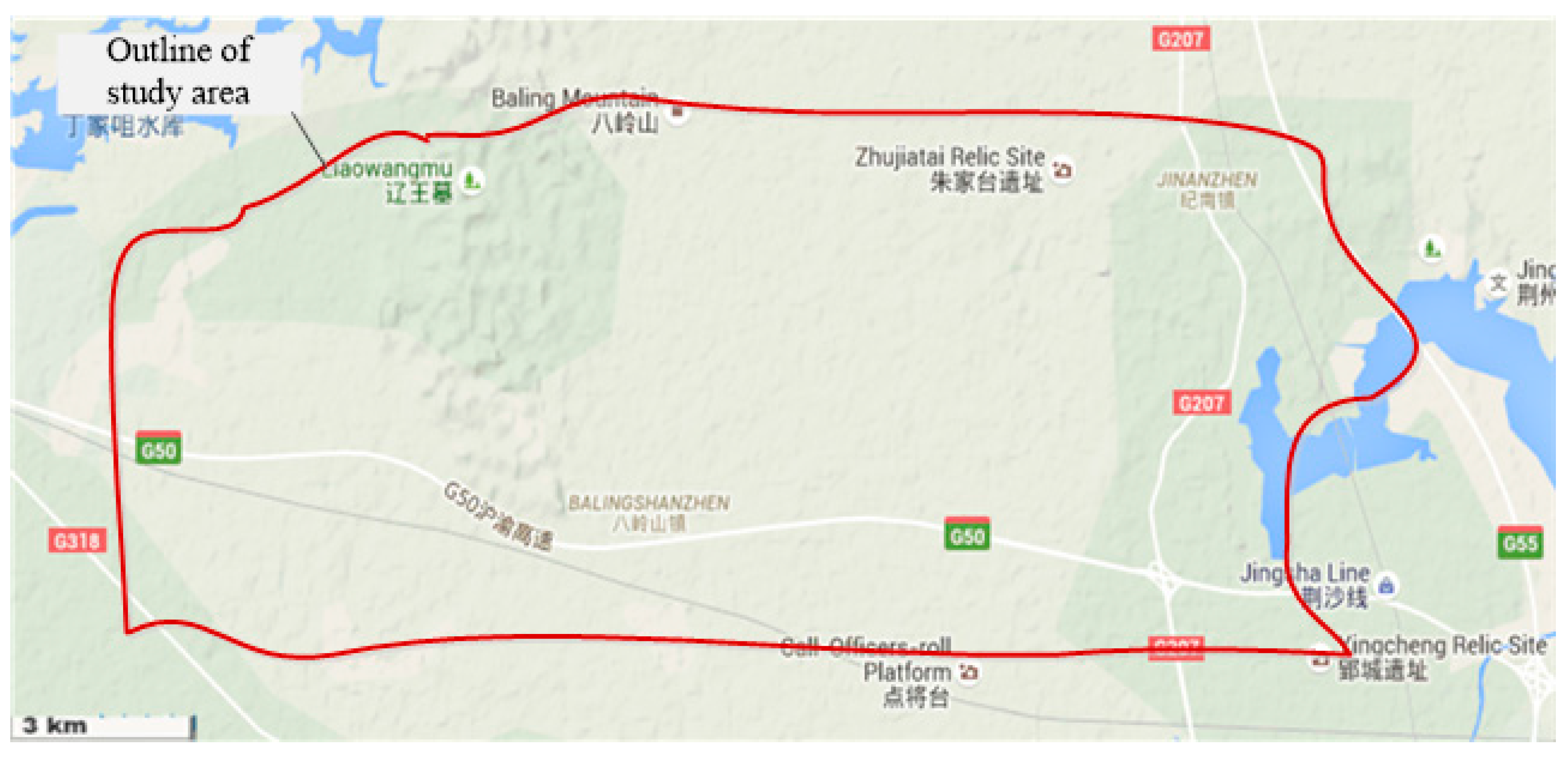
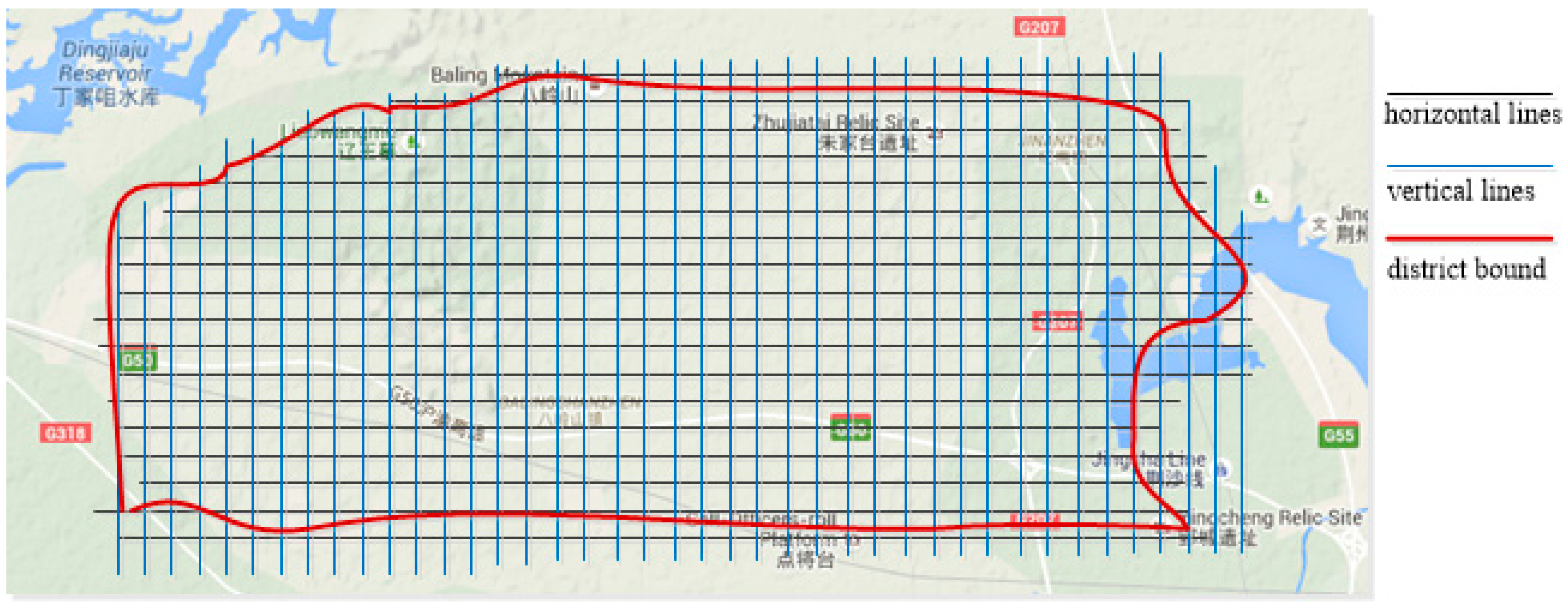
2.1. The Study Area: Balingshan Chu Tomb Group in Jingzhou, China
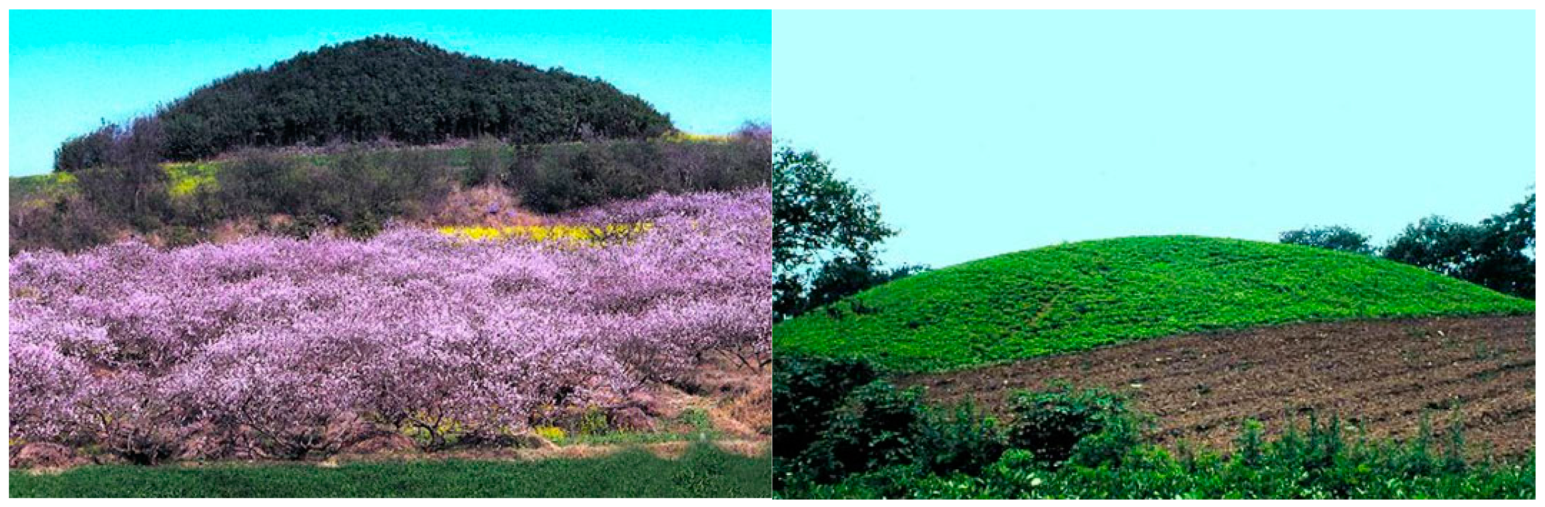
2.2. Difficulties of Tomb Investigation in Balingshan
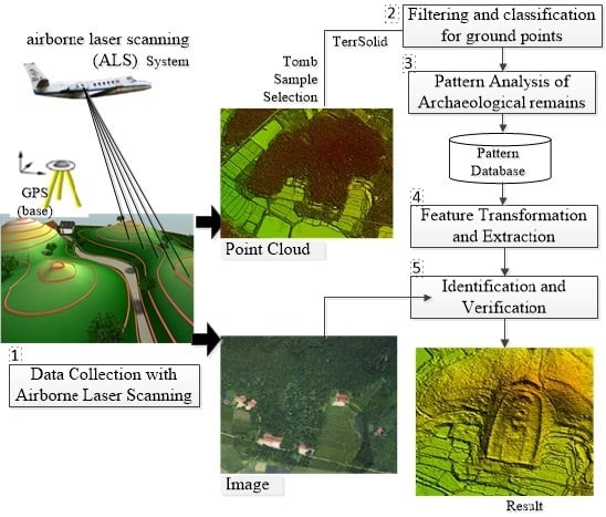
3. Methodology
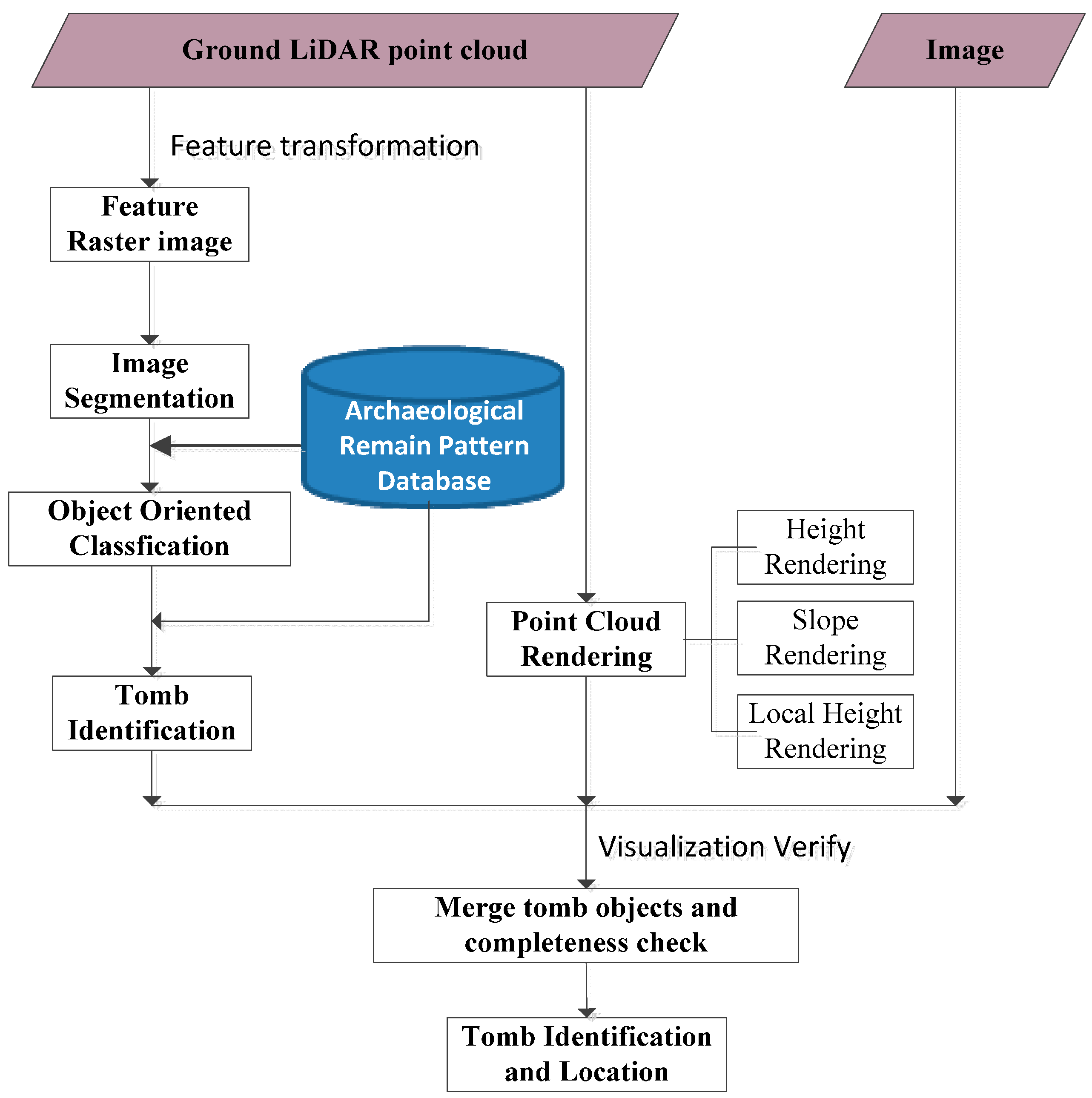
3.1. Framework of the Proposed Approach
3.2. Filtering and Classification to Obtain Ground Points
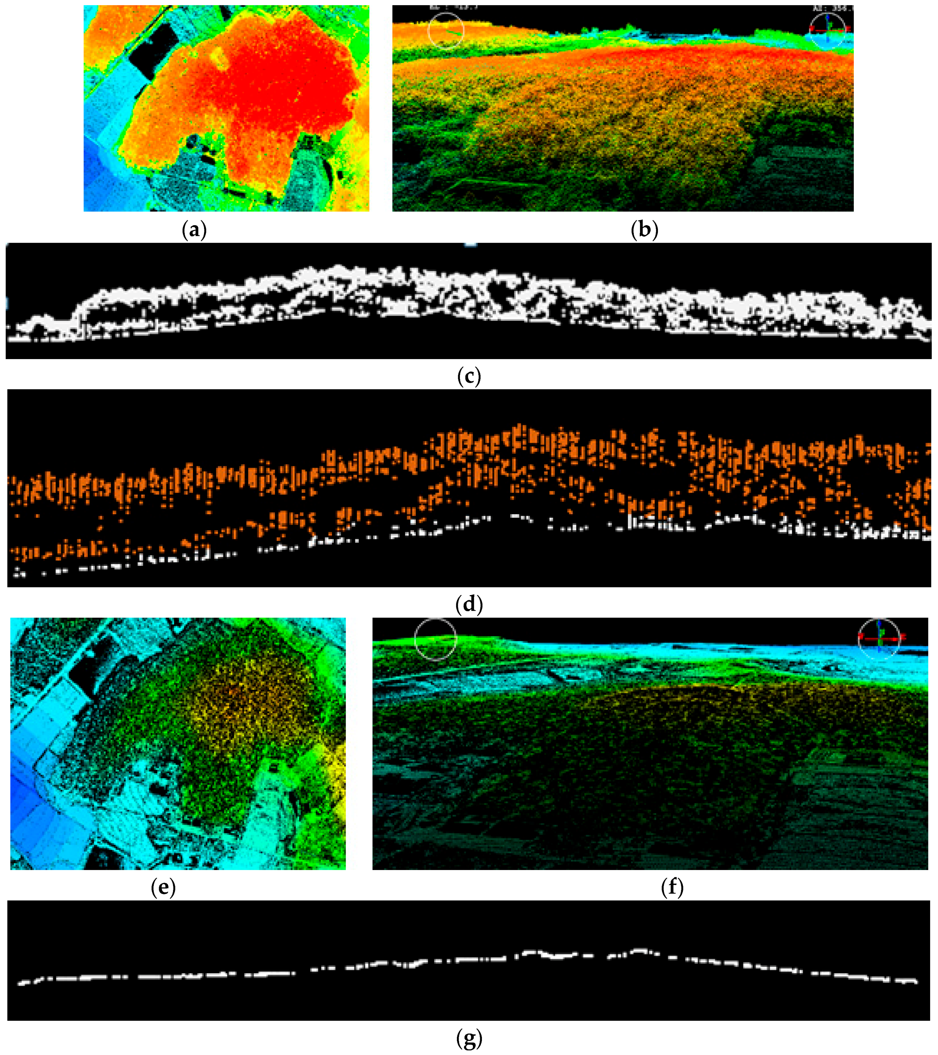
3.3. Pattern Analysis of Chu Tombs in LiDAR Point Cloud Data
3.4. Feature Transformation and Fuzzy Clustering of Tomb Segments
3.4.1. Feature Transformation
3.4.2. Fuzzy Cluster Algorithm for Tomb Segmentation
- (1)
- Step 1: Initialize membership matrix U with a random number based on the constraint of Equation (5).
- (2)
- Step 2: Calculate the cluster center ci using Equation (7).
- (3)
- Step 3: Calculate the cost function using Equation (4). The iterative process stops when the cost function is less than the given threshold or the change in the cost function is less than the established threshold.
- (4)
- Step 4: Recalculate membership matrix U; then, go to Step 2 to run the iterative process.
3.5. Identification and Verification with LiDAR Data and Visible Remote Sensing Images
4. Results, Analysis and Discussion
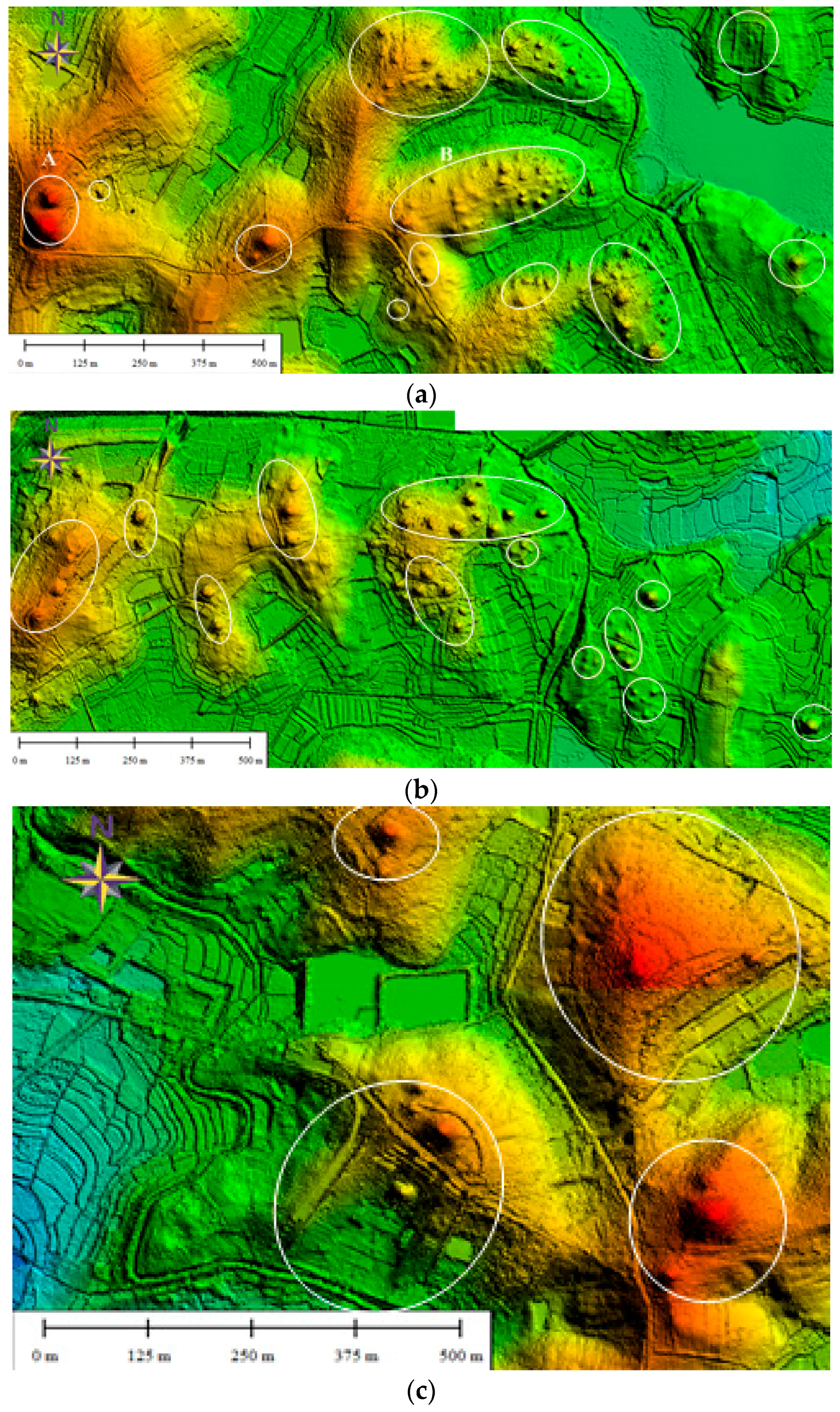
4.1. Chu Tomb Identification Result of the Balingshan District
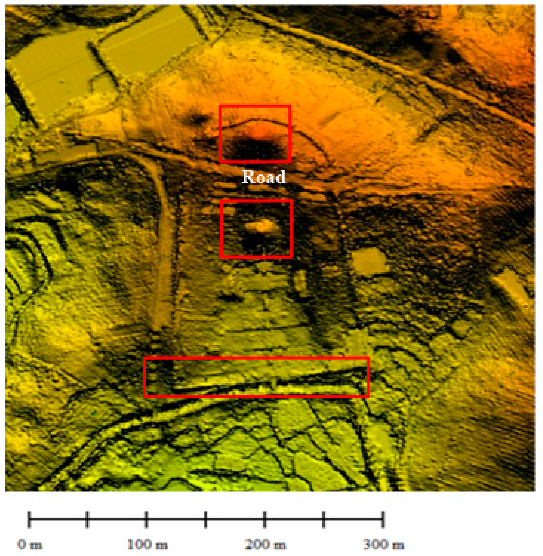
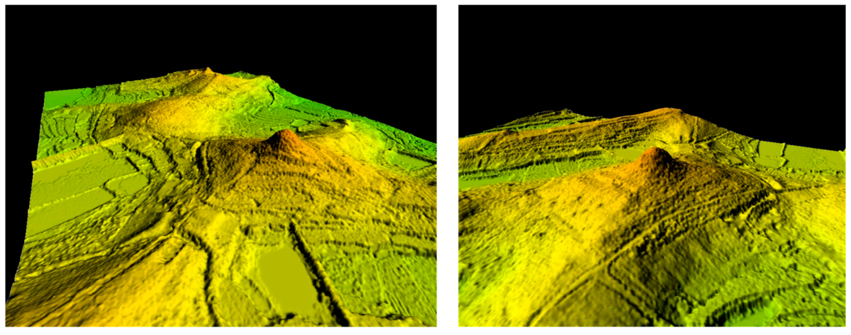
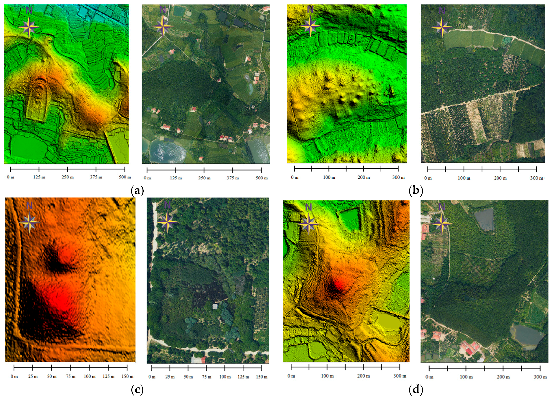
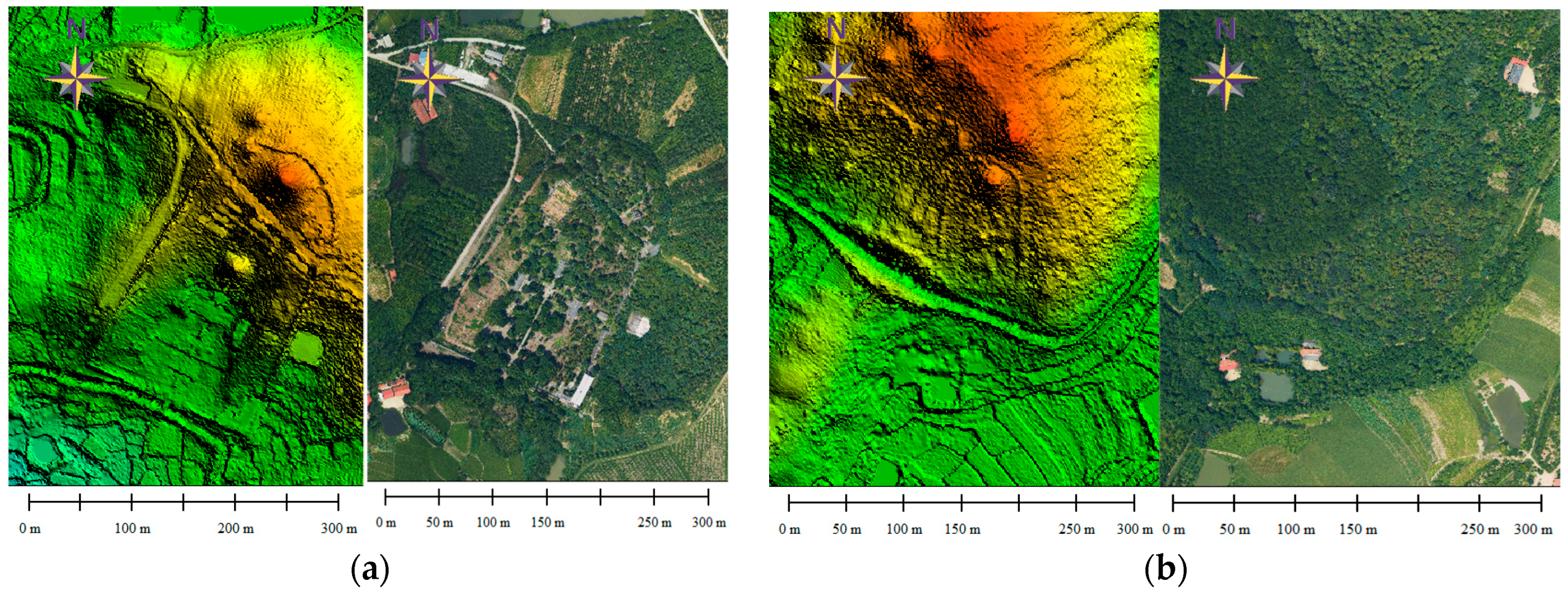
4.2. Discovery and Analysis of Four Typical Chu Tombs
4.3. Discussion
5. Conclusions
Acknowledgments
Author Contributions
Conflicts of Interest
References
- Chase, A.F.; Chase, D.Z.; Fisher, C.T.; Leisz, S.J.; Weishampel, J.F. Geospatial revolution and remote sensing LiDAR in Mesoamerican archaeology. Proc. Natl. Acad. Sci. USA 2012, 109, 12916–12921. [Google Scholar] [CrossRef] [PubMed]
- Hritz, C. Contributions of GIS and Satellite-based Remote Sensing to Landscape Archaeology in the Middle East. J. Archaeol. Res. 2014, 22, 229–276. [Google Scholar] [CrossRef]
- Kincey, M.; Batty, L.; Chapman, H.; Gearey, B.; Ainsworth, S.; Challis, K. Assessing the changing condition of industrial archaeological remains on Alston Moor, UK, using multisensor remote sensing. J. Archaeol. Sci. 2014, 45, 36–51. [Google Scholar] [CrossRef] [Green Version]
- Keay, S.J.; Parcak, S.H.; Strutt, K.D. High resolution space and ground-based remote sensing and implications for landscape archaeology: The case from Portus, Italy. J. Archaeol. Sci. 2014, 52, 277–292. [Google Scholar] [CrossRef]
- Lasaponara, R.; Masini, N. Satellite remote sensing in archaeology: Past, present and future perspectives. J. Archaeol. Sci. 2011, 38, 1995–2002. [Google Scholar] [CrossRef]
- Lasaponara, R.; Coluzzi, R.; Masini, N. Flights into the past: Full-waveform airborne laser scanning data for archaeological investigation. J. Archaeol. Sci. 2011, 38, 2061–2070. [Google Scholar] [CrossRef]
- Rączkowski, W. Aerial archaeology. In Field Archaeology from Around the World; Springer International Publishing: Cham, Switzerland, 2015; pp. 19–25. [Google Scholar]
- Chen, F.; Lasaponara, R.; Masini, N. An overview of satellite synthetic aperture radar remote sensing in archaeology: From site detection to monitoring. J. Cult. Herit. 2015, 23, 5–11. [Google Scholar] [CrossRef]
- Chen, X.T.; Disney, M.I.; Lewis, P.; Armston, J.; Han, J.T.; Li, J.C. Sensitivity of direct canopy gap fraction retrieval from airborne waveform LiDAR to topography and survey characteristics. Remote Sens. Environ. 2014, 143, 15–25. [Google Scholar] [CrossRef]
- Vaughan, M.A.; Young, S.A.; Winker, D.M.; Powell, K.A.; Omar, A.H.; Liu, Z.; Hu, Y.; Hostetler, C.A. Fully automated analysis of space-based LiDAR data: An overview of the CALIPSO retrieval algorithms and data products. In Remote Sensing; International Society for Optics and Photonics: Bellingham, WA, USA, 2004; pp. 16–30. [Google Scholar]
- Devereux, B.J.; Amable, G.S.; Crow, P.; Cliff, A.D. The potential of airborne LiDAR for detection of archaeological features under woodland canopies. Antiquity 2005, 79, 648–660. [Google Scholar] [CrossRef]
- Bewley, R.H.; Crutchley, S.P.; Shell, C.A. New light on an ancient landscape: LiDAR survey in the Stonehenge World Heritage Site. Antiquity 2005, 79, 636–647. [Google Scholar] [CrossRef]
- Harmon, J.M.; Leone, M.P.; Prince, S.D.; Snyder, M. LiDAR for archaeological landscape analysis: A case study of two eighteenth-century Maryland plantation sites. Am. Antiq. 2006, 71, 649–670. [Google Scholar] [CrossRef]
- Rowlands, A.; Sarris, A. Detection of exposed and subsurface archaeological remains using multi-sensor remote sensing. J. Archaeol. Sci. 2007, 34, 795–803. [Google Scholar] [CrossRef]
- Challis, K. Airborne laser altimetry in alluviated landscapes. Archaeol. Prospect. 2006, 13, 103–127. [Google Scholar] [CrossRef]
- Challis, K.; Forlin, P.; Kincey, M. A generic toolkit for the visualization of archaeological features on airborne LiDAR elevation data. Archaeol. Prospect. 2011, 18, 279–289. [Google Scholar] [CrossRef]
- Doneus, M.; Briese, C.; Fera, M.; Janner, M. Archaeological prospection of forested areas using full-waveform airborne laser scanning. J. Archaeol. Sci. 2008, 35, 882–893. [Google Scholar] [CrossRef]
- Gallagher, J.M.; Josephs, R.L. Using LiDAR to detect cultural resources in a forested environment: An example from Isle Royale National Park, Michigan, USA. Archaeol. Prospect. 2008, 15, 187–206. [Google Scholar] [CrossRef]
- McCoy, M.D.; Ladefoged, T.N. New developments in the use of spatial technology in archaeology. J. Archaeol. Res. 2009, 17, 263–295. [Google Scholar] [CrossRef]
- Masini, N.; Lasaponara, R. Airborne LiDAR in archaeology: Overview and a case study. In Proceedings of the International Conference on Computational Science and Its Applications, Ho Chi Minh City, Vietnam, 24–27 June 2013; pp. 663–676. [Google Scholar]
- McCoy, M.D.; Asner, G.P.; Graves, M.W. Airborne LiDAR survey of irrigated agricultural landscapes: An application of the slope contrast method. J. Archaeol. Sci. 2011, 38, 2141–2154. [Google Scholar] [CrossRef]
- Chase, A.F.; Chase, D.Z.; Weishampel, J.F.; Drake, J.B.; Shrestha, R.M.; Slatton, K.C.; Awe, J.J.; Carter, W.E. Airborne LiDAR, archaeology, and the ancient Maya landscape at Caracol, Belize. J. Archaeol. Sci. 2011, 38, 387–398. [Google Scholar] [CrossRef]
- Chase, A.F.; Chase, D.Z.; Weishampel, J.F. Lasers in the Jungle. Archaeology 2010, 63, 27–29. [Google Scholar]
- Rochelo, M.J.; Davenport, C.; Selch, D. Revealing pre-historic Native American Belle Glade earthworks in the Northern Everglades utilizing airborne LiDAR. J. Archaeol. Sci. Rep. 2015, 2, 624–643. [Google Scholar] [CrossRef]
- Johnson, K.M.; Ouimet, W.B. Rediscovering the lost archaeological landscape of southern New England using airborne light detection and ranging (LiDAR). J. Archaeol. Sci. 2014, 43, 9–20. [Google Scholar] [CrossRef]
- Stott, D.; Boyd, D.S.; Beck, A.; Cohn, A.G. Airborne LiDAR for the detection of archaeological vegetation marks using biomass as a proxy. Remote Sens. 2015, 7, 1594–1618. [Google Scholar] [CrossRef]
- Opitz, R.; Nuninger, L. Point Clouds Segmentation of Mixed Scenes with Archeological Standing Remains: A Multi-Criteria and Multi-Scale Iterative Approach. Int. J. Herit. Dig. Era 2014, 3, 287–304. [Google Scholar] [CrossRef]
- Roussel, E.; Toumazet, J.P.; Florez, M.; Vautier, F.; Dousteyssier, B. Using airborne LiDAR in geoarchaeological contexts: Assessment of an automatic tool for the detection and the morphometric analysis of grazing archaeological structures (French Massif Central). In Proceedings of the EGU General Assembly Conference, Vienna, Austria, 27 April–2 May 2014; Volume 16, p. 7160. [Google Scholar]
- Fernández-Lozano, J.; Gutiérrez-Alonso, G.; Fernández-Morán, M.Á. Using airborne LiDAR sensing technology and aerial orthoimages to unravel roman water supply systems and gold works in NW Spain (Eria valley, León). J. Archaeol. Sci. 2015, 53, 356–373. [Google Scholar] [CrossRef]
- Kusiak, A. Feature transformation methods in data mining. IEEE Trans. Electron. Packag. Manuf. 2001, 24, 214–221. [Google Scholar] [CrossRef]
- Liu, X. Airborne LiDAR for DEM generation: Some critical issues. Prog. Phys. Geogr. 2008, 32, 31–49. [Google Scholar]
- Mongus, D.; Žalik, B. Parameter-free ground filtering of LiDAR data for automatic DTM generation. ISPRS J. Photogramm. Remote Sens. 2012, 67, 1–12. [Google Scholar] [CrossRef]
- Schindling, J.; Gibbes, C. LiDAR as a tool for archaeological research: A case study. Archaeol. Anthropol. Sci. 2014, 6, 411–423. [Google Scholar] [CrossRef]
- Hare, T.; Masson, M.; Russell, B. High-Density LiDAR Mapping of the Ancient City of Mayapán. Remote Sens. 2014, 6, 9064–9085. [Google Scholar] [CrossRef]
- Mei, J.; Wang, P.; Chen, K.; Wang, L.; Wang, L.; Liu, Y. Archaeometallurgical studies in China: Some recent developments and challenging issues. J. Archaeol. Sci. 2015, 56, 221–232. [Google Scholar] [CrossRef]
- Cook, C.A.; Major, J.S. (Eds.) Defining Chu: Image and Reality in Ancient China; University of Hawaii Press: Honolulu, HI, USA, 2004. [Google Scholar]
- Bai, X.; Gong, Y.; Yang, H. A potential scavenger of carbon radicals for ancient carbonized silk fabrics: Superoxide Dismutase (SOD). Herit. Sci. 2014, 2, 27. [Google Scholar] [CrossRef]
- Shan, J.; Toth, C.K. (Eds.) Topographic Laser Ranging and Scanning: Principles and Processing; CRC Press: Boca Raton, FL, USA, 2008. [Google Scholar]
- Lemmens, M. Product Survey on Airborne LiDAR Sensors. GIM Int. 2007, 21, 24–27. [Google Scholar]
- Schuckman, K.; Hoffman, G.R. ARIES: Technology fusion for emergency response. Photogramm. Eng. Remote Sens. 2005, 71, 357–360. [Google Scholar]
- Terrasolid TerraScan User’s Guide. Available online: http://www.terrasolid.com/download/tscan.pdf (accessed on 20 August 2016).
- Kraus, K.; Pfeifer, N. Advanced DTM generation from LiDAR data. Int. Arch. Photogramm. Remote Sens. Spat. Inf. Sci. 2001, 34, 23–30. [Google Scholar]
- Boskovitz, V.; Guterman, H. An adaptive neuro-fuzzy system for automatic image segmentation and edge detection. IEEE Trans. Fuzzy Syst. 2002, 10, 247–262. [Google Scholar] [CrossRef]
- Harrower, M.J. Hydrology, ideology, and the origins of irrigation in ancient Southwest Arabia. Curr. Anthropol. 2008, 49, 497–510. [Google Scholar] [CrossRef]
- Wiseman, J.R.; El-Baz, F. Remote Sensing in Archaeology; Springer Science & Business Media: Berlin, Germany, 2007. [Google Scholar]


| Tomb Patterns Used | Total Number of Discovered Tombs | Number of Known Tombs | Number of New Tombs |
|---|---|---|---|
| 12 | 315 | 168 | 147 |
© 2017 by the authors. Licensee MDPI, Basel, Switzerland. This article is an open access article distributed under the terms and conditions of the Creative Commons Attribution (CC BY) license (http://creativecommons.org/licenses/by/4.0/).
Share and Cite
Wang, S.; Hu, Q.; Wang, F.; Ai, M.; Zhong, R. A Microtopographic Feature Analysis-Based LiDAR Data Processing Approach for the Identification of Chu Tombs. Remote Sens. 2017, 9, 880. https://doi.org/10.3390/rs9090880
Wang S, Hu Q, Wang F, Ai M, Zhong R. A Microtopographic Feature Analysis-Based LiDAR Data Processing Approach for the Identification of Chu Tombs. Remote Sensing. 2017; 9(9):880. https://doi.org/10.3390/rs9090880
Chicago/Turabian StyleWang, Shaohua, Qingwu Hu, Fengzhu Wang, Mingyao Ai, and Ruofei Zhong. 2017. "A Microtopographic Feature Analysis-Based LiDAR Data Processing Approach for the Identification of Chu Tombs" Remote Sensing 9, no. 9: 880. https://doi.org/10.3390/rs9090880
APA StyleWang, S., Hu, Q., Wang, F., Ai, M., & Zhong, R. (2017). A Microtopographic Feature Analysis-Based LiDAR Data Processing Approach for the Identification of Chu Tombs. Remote Sensing, 9(9), 880. https://doi.org/10.3390/rs9090880