
A Dark Target Algorithm for the GOSAT TANSO-CAI Sensor in Aerosol Optical Depth Retrieval over Land


 , ,
, ,
Abstract
:
1. Introduction
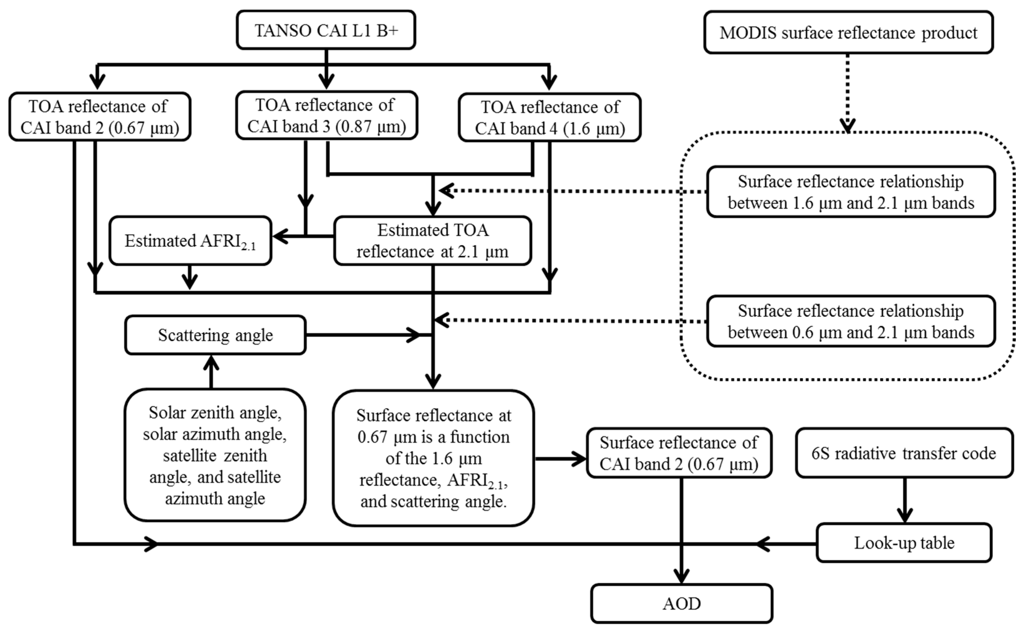
2. Theoretical Basis of AOD Retrieval
3. Materials and Methods
3.1. Satellite Data and Ground-Level Data
3.1.1. GOSAT TANSO-CAI Data
3.1.2. MODIS Surface Reflectance Product (MOD09)
3.1.3. AERONET AOD Data
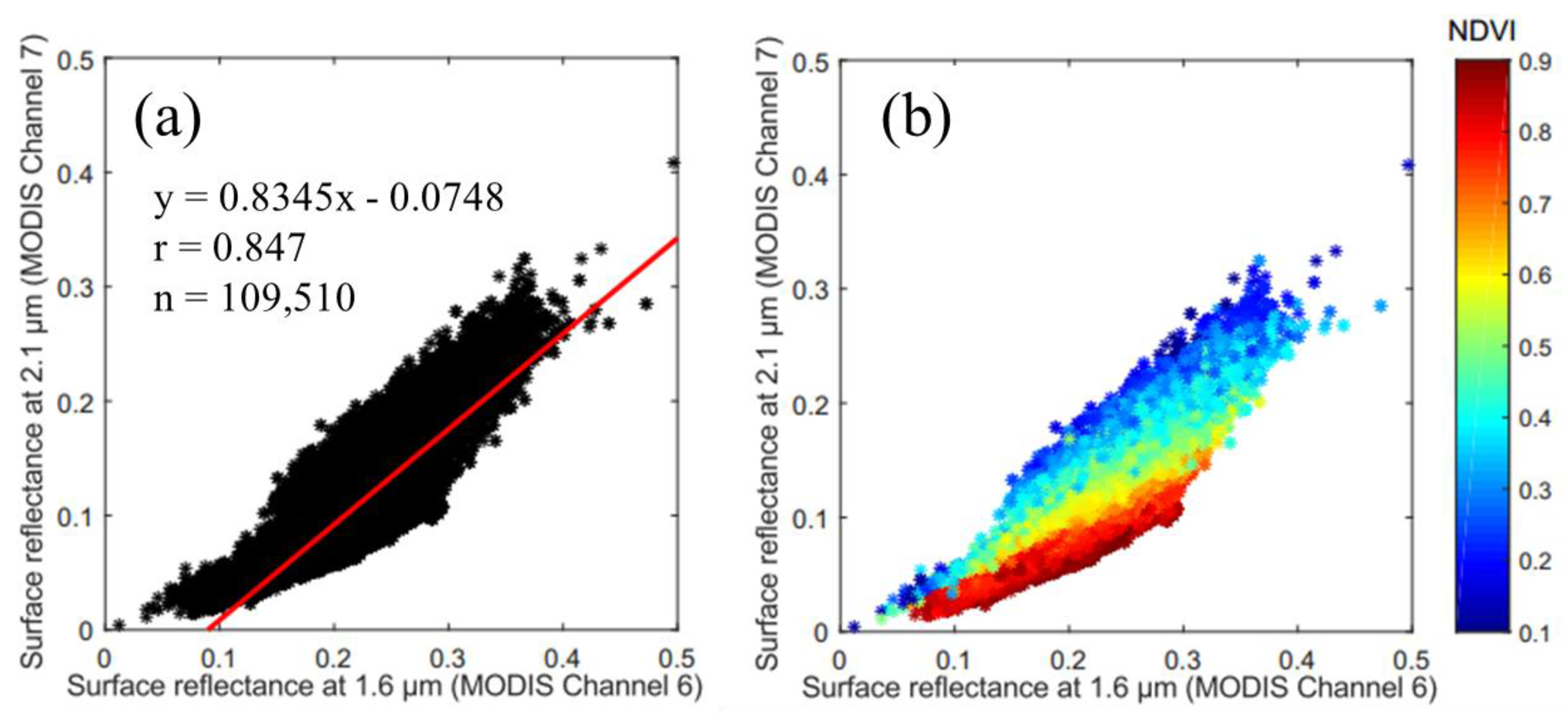
3.2. The Relationship between Reflectances at 1.6 μm and 2.1 μm
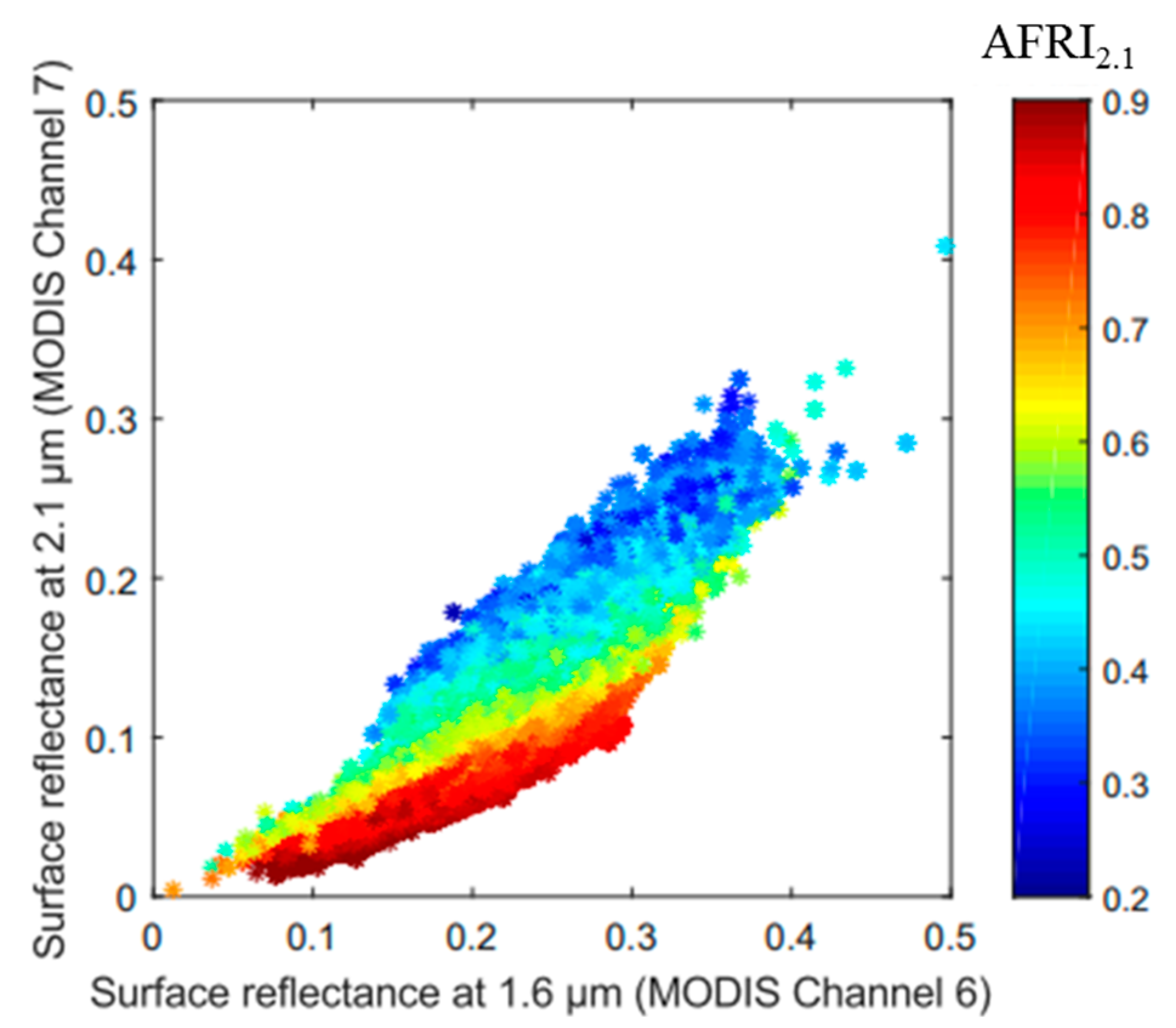
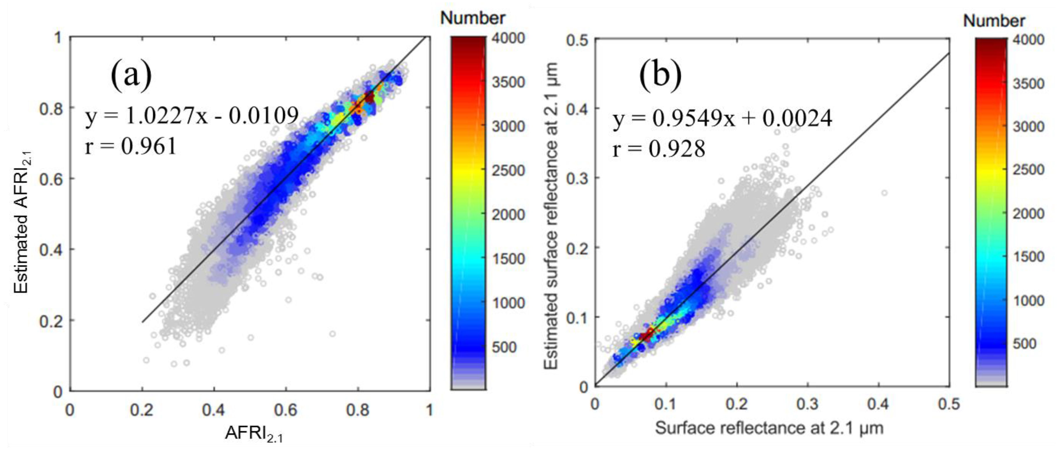
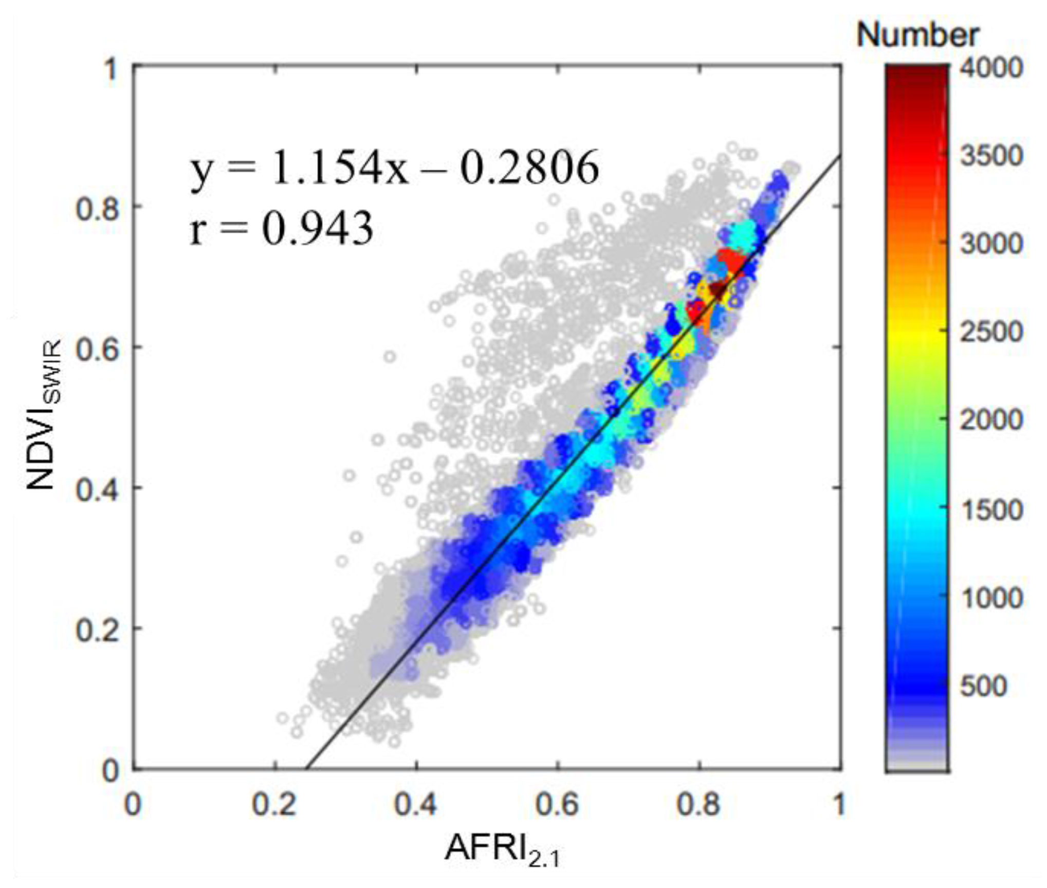
3.3. Estimation of Aerosol Free Vegetation Index (AFRI2.1) Using NIR and 1.6 μm Bands
3.4. Estimation of TANSO-CAI Surface Reflectance at 0.67 μm from the 1.6 μm Band
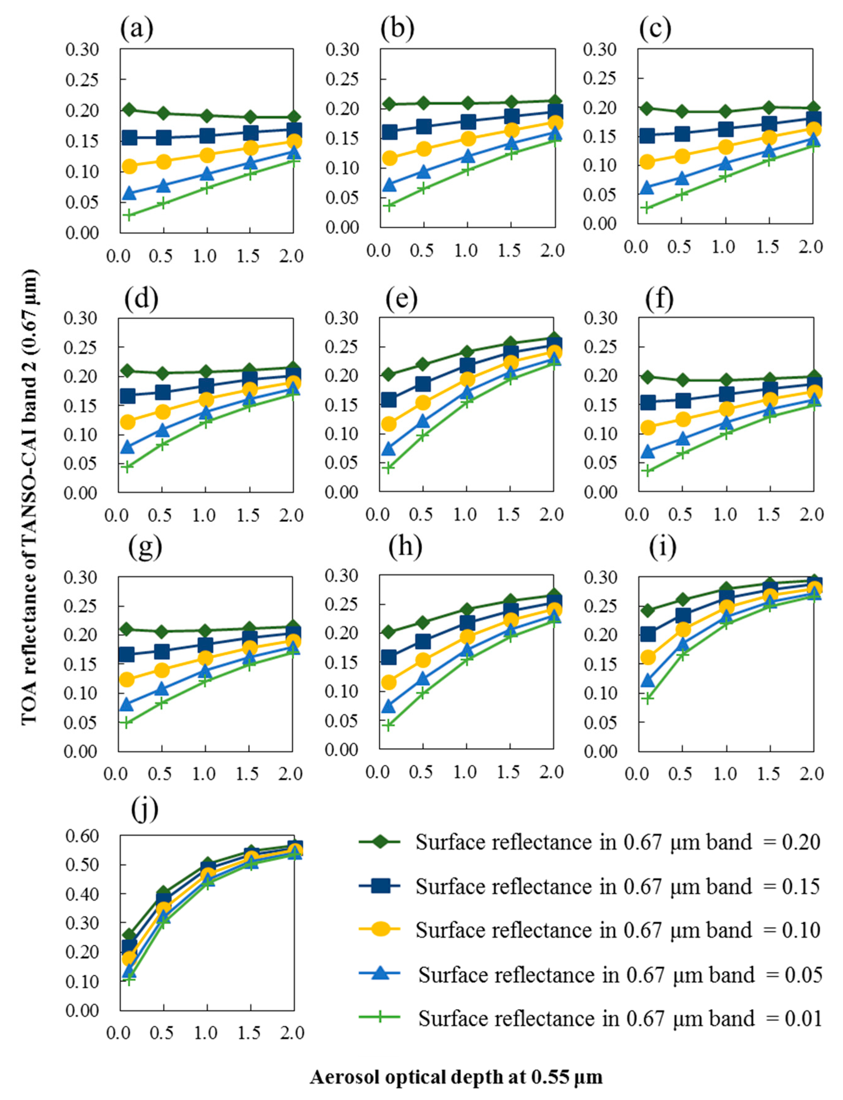
3.5. AOD Retrieval
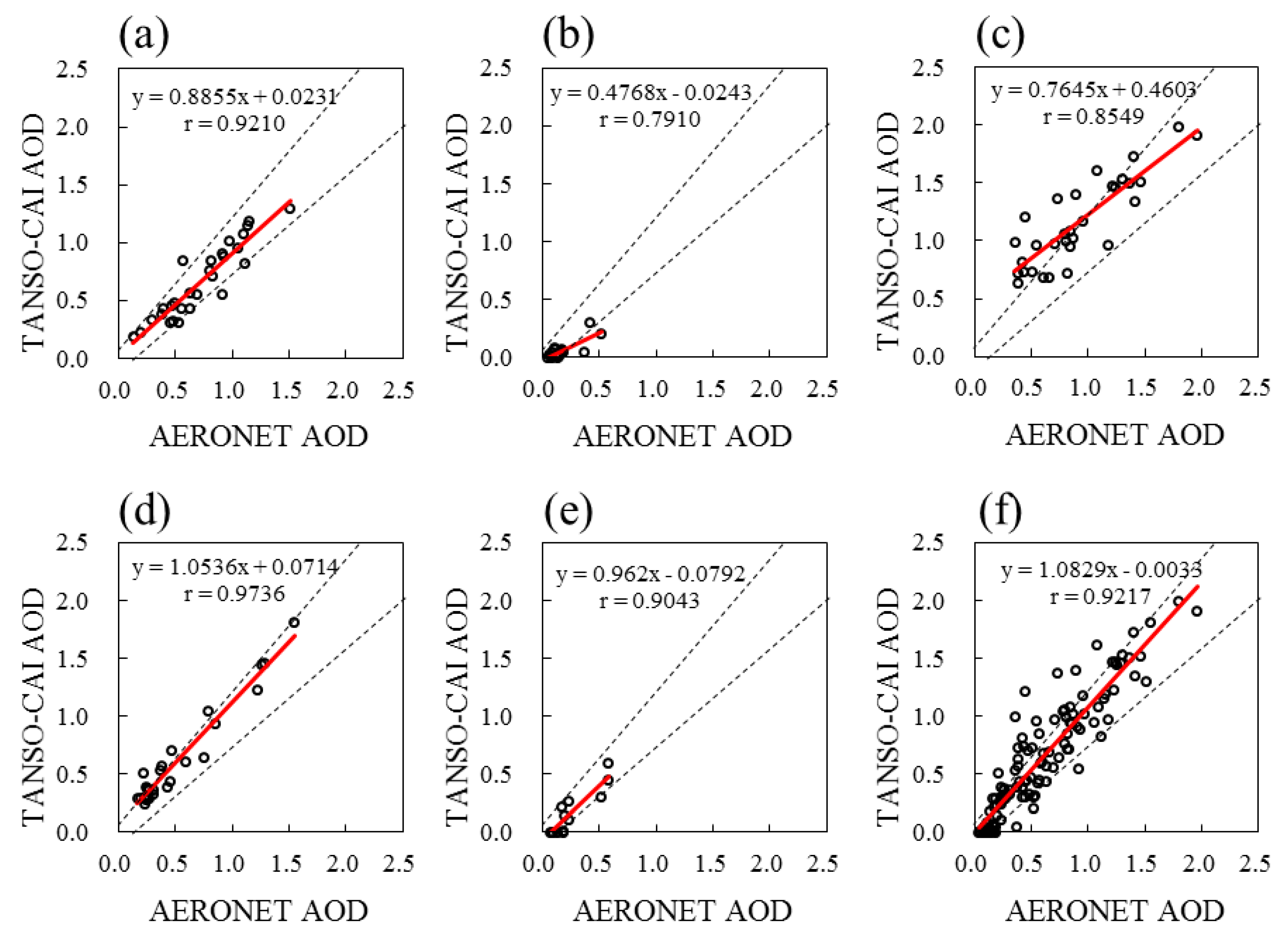
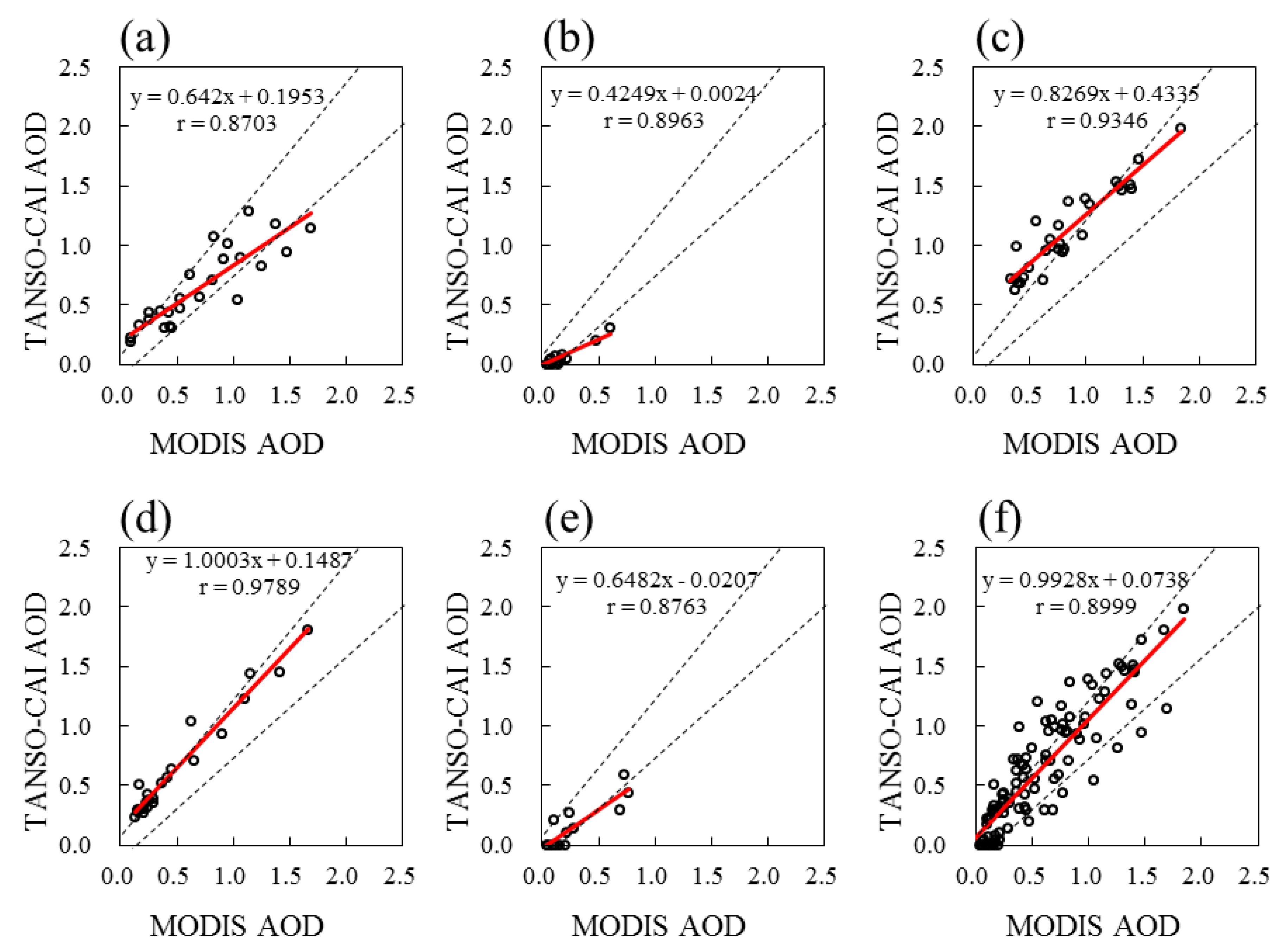
4. Results and Discussion
5. Conclusions
Acknowledgments
Author Contributions
Conflicts of Interest
References
- Sun, L.; Wei, J.; Bilal, M.; Tian, X.; Jia, C.; Guo, Y.; Mi, X. Aerosol Optical Depth Retrieval over Bright Areas Using Landsat 8 OLI Images. Remote Sens. 2015, 8, 23. [Google Scholar] [CrossRef]
- Choudhry, P.; Misra, A.; Tripathi, S. Study of MODIS derived AOD at three different locations in the Indo Gangetic Plain: Kanpur, Gandhi College and Nainital. Ann. Geophys. 2012, 30, 1479–1493. [Google Scholar] [CrossRef]
- Mateos, D.; Anton, M.; Toledano, C.; Cachorro, V.; Alados-Arboledas, L.; Sorribas, M.; Costa, M.J.; Baldasano, J. Aerosol radiative effects in the ultraviolet, visible, and near-infrared spectral ranges using long-term aerosol data series over the Iberian Peninsula. Atmos. Chem. Phys. 2014, 14, 13497–13514. [Google Scholar] [CrossRef]
- Jiang, X.; Liu, Y.; Yu, B.; Jiang, M. Comparison of MISR aerosol optical thickness with AERONET measurements in Beijing metropolitan area. Remote Sens. Environ. 2007, 107, 45–53. [Google Scholar] [CrossRef]
- Zhang, H.; Hoff, R.; Kondragunta, S.; Laszlo, I.; Lyapustin, A. Aerosol optical depth (AOD) retrieval using simultaneous GOES-East and GOES-West reflected radiances over the western United States. Atmos. Meas. Tech. 2013, 6, 471–486. [Google Scholar] [CrossRef]
- Riffler, M.; Popp, C.; Hauser, A.; Fontana, F.; Wunderle, S. Validation of a modified AVHRR aerosol optical depth retrieval algorithm over Central Europe. Atmos. Meas. Tech. 2010, 3, 1255–1270. [Google Scholar] [CrossRef]
- Liu, Y.; Park, R.J.; Jacob, D.J.; Li, Q.; Kilaru, V.; Sarnat, J.A. Mapping annual mean ground-level PM2.5 concentrations using Multiangle Imaging Spectroradiometer aerosol optical thickness over the contiguous United States. J. Geophys. Res. Atmos. 2004, 109. [Google Scholar] [CrossRef]
- NOAA Earth System Research Laboratory Global Monitoring Division Global Radiation Group. Available online: https://www.esrl.noaa.gov/gmd/grad/surfrad/aod/ (accessed on 8 January 2017).
- Kaufman, Y.; Tanré, D.; Gordon, H.; Nakajima, T.; Lenoble, J.; Frouin, R.; Grassl, H.; Herman, B.; King, M.; Teillet, P. Passive remote sensing of tropospheric aerosol and atmospheric correction for the aerosol effect. J. Geophys. Res. Atmos. 1997, 102, 16815–16830. [Google Scholar] [CrossRef]
- Kaufman, Y.; Tanré, D.; Remer, L.A.; Vermote, E.; Chu, A.; Holben, B. Operational remote sensing of tropospheric aerosol over land from EOS moderate resolution imaging spectroradiometer. J. Geophys. Res. Atmos. 1997, 102, 17051–17067. [Google Scholar] [CrossRef]
- Kokhanovsky, A.; Breon, F.-M.; Cacciari, A.; Carboni, E.; Diner, D.; Di Nicolantonio, W.; Grainger, R.; Grey, W.; Höller, R.; Lee, K.-H. Aerosol remote sensing over land: A comparison of satellite retrievals using different algorithms and instruments. Atmos. Res. 2007, 85, 372–394. [Google Scholar] [CrossRef]
- De Leeuw, G.; Holzer-Popp, T.; Bevan, S.; Davies, W.H.; Descloitres, J.; Grainger, R.G.; Griesfeller, J.; Heckel, A.; Kinne, S.; Klüser, L. Evaluation of seven European aerosol optical depth retrieval algorithms for climate analysis. Remote Sens. Environ. 2015, 162, 295–315. [Google Scholar] [CrossRef]
- Kaufman, Y.J.; Wald, A.E.; Remer, L.A.; Gao, B.-C.; Li, R.-R.; Flynn, L. The MODIS 2.1-μm channel-correlation with visible reflectance for use in remote sensing of aerosol. IEEE Trans. Geosci. Remote Sens. 1997, 35, 1286–1298. [Google Scholar] [CrossRef]
- Remer, L.A.; Kaufman, Y.; Tanré, D.; Mattoo, S.; Chu, D.; Martins, J.V.; Li, R.-R.; Ichoku, C.; Levy, R.; Kleidman, R. The MODIS aerosol algorithm, products, and validation. J. Atmos. Sci. 2005, 62, 947–973. [Google Scholar] [CrossRef]
- Diner, D.J.; Martonchik, J.V.; Kahn, R.A.; Pinty, B.; Gobron, N.; Nelson, D.L.; Holben, B.N. Using angular and spectral shape similarity constraints to improve MISR aerosol and surface retrievals over land. Remote Sens. Environ. 2005, 94, 155–171. [Google Scholar] [CrossRef]
- Grey, W.M.; North, P.R.; Los, S.O.; Mitchell, R.M. Aerosol optical depth and land surface reflectance from multiangle AATSR measurements: Global validation and intersensor comparisons. IEEE Trans. Geosci. Remote Sens. 2006, 44, 2184–2197. [Google Scholar] [CrossRef]
- Deuzé, J.; Bréon, F.; Devaux, C.; Goloub, P.; Herman, M.; Lafrance, B.; Maignan, F.; Marchand, A.; Nadal, F.; Perry, G. Remote sensing of aerosols over land surfaces from POLDER-ADEOS-1 polarized measurements. J. Geophys. Res. Atmos. 2001, 106, 4913–4926. [Google Scholar] [CrossRef]
- Levy, R.C.; Remer, L.A.; Mattoo, S.; Vermote, E.F.; Kaufman, Y.J. Second-generation operational algorithm: Retrieval of aerosol properties over land from inversion of Moderate Resolution Imaging Spectroradiometer spectral reflectance. J. Geophys. Res. Atmos. 2007, 112. [Google Scholar] [CrossRef]
- Levy, R.; Mattoo, S.; Munchak, L.; Remer, L.; Sayer, A.; Patadia, F.; Hsu, N. The Collection 6 MODIS aerosol products over land and ocean. Atmos. Meas. Tech. 2013, 6, 2989–3034. [Google Scholar] [CrossRef]
- Soufflet, V.; Tanré, D.; Royer, A.; O‘Neil, N. Remote sensing of aerosols over boreal forest and lake water from AVHRR data. Remote Sens. Environ. 1997, 60, 22–34. [Google Scholar] [CrossRef]
- Mei, L.; Xue, Y.; Kokhanovsky, A.; von Hoyningen-Huene, W.; de Leeuw, G.; Burrows, J. Retrieval of aerosol optical depth over land surfaces from AVHRR data. Atmos. Meas. Tech. Discuss. 2013, 6, 2227–2251. [Google Scholar] [CrossRef]
- Holzer-Popp, T.; Schroedter-Homscheidt, M.; Breitkreuz, H.; Martynenko, D.; Klüser, L. Improvements of synergetic aerosol retrieval for ENVISAT. Atmos. Chem. Phys. 2008, 8, 7651–7672. [Google Scholar] [CrossRef]
- Xie, D.; Cheng, T.; Zhang, W.; Yu, J.; Li, X.; Gong, H. Aerosol type over east Asian retrieval using total and polarized remote sensing. J. Quant. Spectrosc. Radiat. Transf. 2013, 129, 15–30. [Google Scholar] [CrossRef]
- Levy, R.; Munchak, L.; Mattoo, S.; Patadia, F.; Remer, L.; Holz, R. Towards a long-term global aerosol optical depth record: Applying a consistent aerosol retrieval algorithm to MODIS and VIIRS-observed reflectance. Atmos. Meas. Tech. 2015, 8, 4083–4110. [Google Scholar] [CrossRef]
- Dark Target (MODIS Aerosol Retrieval Algorithm), About the Algorithm. Available online: https://darktarget.gsfc.nasa.gov/algorithm (accessed on 26 December 2016).
- Dark Target (MODIS Aerosol Retrieval Algorithm). Available online: http://darktarget.gsfc.nasa.gov/content/what-difference-between-dark-target-and-deep-blue (accessed on 28 December 2016).
- Hsu, N.; Jeong, M.J.; Bettenhausen, C.; Sayer, A.; Hansell, R.; Seftor, C.; Huang, J.; Tsay, S.C. Enhanced deep blue aerosol retrieval algorithm: The second generation. J. Geophys. Res. Atmos. 2013, 118, 9296–9315. [Google Scholar] [CrossRef]
- Dark Target (MODIS Aerosol Retrieval Algorithm), Platforms, VIIRS. Available online: https://darktarget.gsfc.nasa.gov/platforms/viirs (accessed on 26 December 2016).
- Fukuda, S.; Nakajima, T.; Takenaka, H.; Higurashi, A.; Kikuchi, N.; Nakajima, T.Y.; Ishida, H. New approaches to removing cloud shadows and evaluating the 380 nm surface reflectance for improved aerosol optical thickness retrievals from the GOSAT/TANSO-Cloud and Aerosol Imager. J. Geophys. Res.: Atmos. 2013, 118, 13520–13531. [Google Scholar] [CrossRef]
- Greenhouse Gases Observing SATellite Project. Available online: http://www.gosat.nies.go.jp/eng/GOSAT_pamphlet_en.pdf (accessed on 26 December 2016).
- Gao, L.; Li, J.; Chen, L.; Zhang, L.; Heidinger, A.K. Retrieval and validation of atmospheric aerosol optical depth from AVHRR over China. IEEE Trans. Geosci. Remote Sens. 2016, 54, 6280–6291. [Google Scholar] [CrossRef]
- Algorithm Theoretical Basis Document (ATBD) for CO2 and CH4 Columun Amounts Retrieval from GOSAT TANSO-FTS SWIR. Available online: http://data.gosat.nies.go.jp/GosatUserInterfaceGateway/guig/doc/documents/ATBD_FTSSWIRL2_V1.1_en.pdf (accessed on 26 December 2016).
- Jung, Y.; Kim, J.; Kim, W.; Boesch, H.; Lee, H.; Cho, C.; Goo, T.-Y. Impact of aerosol property on the accuracy of a CO2 retrieval algorithm from satellite remote sensing. Remote Sens. 2016, 8, 322. [Google Scholar] [CrossRef]
- Sun, L.; Sun, C.; Liu, Q.; Zhong, B. Aerosol optical depth retrieval by HJ-1/CCD supported by MODIS surface reflectance data. Sci. China Earth Sci. 2010, 53, 74–80. [Google Scholar] [CrossRef]
- Istomina, L.; von Hoyningen-Huene, W.; Kokhanovsky, A.; Schultz, E.; Burrows, J. Remote sensing of aerosols over snow using infrared AATSR observations. Atmos. Meas. Tech. 2011, 4, 1133–1145. [Google Scholar] [CrossRef]
- Zhang, Y.; Li, Z.; Qie, L.; Zhang, Y.; Liu, Z.; Chen, X.; Hou, W.; Li, K.; Li, D.; Xu, H. Retrieval of Aerosol Fine-Mode Fraction from Intensity and Polarization Measurements by PARASOL over East Asia. Remote Sens. 2016, 8, 417. [Google Scholar] [CrossRef]
- Hou, P.; Jiang, W.; Cao, G.; Li, J. Aerosol retrieval with satellite image and correlation analyses between aerosol distribution and urban underlaying surface. Int. J. Remote Sens. 2012, 33, 3232–3251. [Google Scholar] [CrossRef]
- Remer, L.A.; Wald, A.E.; Kaufman, Y.J. Angular and seasonal variation of spectral surface reflectance ratios: Implications for the remote sensing of aerosol over land. IEEE Trans. Geosci. Remote Sens. 2001, 39, 275–283. [Google Scholar] [CrossRef]
- Gatebe, C.K.; King, M.D.; Tsay, S.-C.; Ji, Q.; Arnold, G.T.; Li, J.Y. Sensitivity of off-nadir zenith angles to correlation between visible and near-infrared reflectance for use in remote sensing of aerosol over land. IEEE Trans. Geosci. Remote Sens. 2001, 39, 805–819. [Google Scholar] [CrossRef]
- Lyapustin, A.I. Three-dimensional effects in the remote sensing of surface albedo. IEEE Trans. Geosci. Remote Sens. 2001, 39, 254–263. [Google Scholar] [CrossRef]
- Algorithm Theoretical Basis Document for TANSO-CAI L1B Processing. Available online: https://data.gosat.nies.go.jp/GosatWebDds/productorder/distribution/user/ATBD_CAIL1B_V1.0_en.pdf (accessed on 22 December 2016).
- Algorithm Theoretical Basis Document for TANSO-CAI L1B+ Processing. Available online: https://data.gosat.nies.go.jp/GosatWebDds/productorder/distribution/user/ATBD_CAIL1BP_V1.01_en.pdf (accessed on 23 December 2016).
- NIES GOSAT Product Format Descriptions. Available online: https://data.gosat.nies.go.jp/GosatWebDds/productorder/distribution/user/GOSAT_ProductDescription_V1.50_en.pdf (accessed on 24 December 2016).
- Vermote, E.F.; Kotchenova, R.; Ray, J. MODIS Surface Reflectance User’s Guide. Version 1.3. MODIS Land Surface Reflectance Science Computing Facility. Available online: http: modis-sr.ltdri.org/products/MOD09_UserGuide_v1_3. pdf (accessed on 28 October 2016).
- Modis Land Surface Reflectance Science Computing Facility Homepage. Available online: https://modis-sr.ltdri.org/index.html (accessed on 25 December 2016).
- Wang, S.; Yang, M.; Li, J.; Shen, Q.; Zhang, F. MODIS surface reflectance product (MOD09) validation for typical inland waters in China. In Proceedings of the SPIE Ocean Remote Sensing and Monitoring from Space, Beijing, China, 13 October 2014; International Society for Optics and Photonics: Bellingham, WA, USA, 2014. [Google Scholar] [CrossRef]
- Fan, L.; Berger, F.H.; Liu, H.; Bernhofer, C. Validating MODIS land surface reflectance products using ground-measured reflectance spectra—A case study in semi-arid grassland in Inner Mongolia, China. Int. J. Remote Sens. 2014, 35, 1715–1728. [Google Scholar] [CrossRef]
- Vermote, E.F.; Kotchenova, S. MODIS Meetings—MODIS Land Collection 5 Workshop Presentations. Available online: https://modis.gsfc.nasa.gov/sci_team/meetings/c5meeting/pres/day1/vermote.pdf (accessed on 28 October 2016).
- Holben, B.N.; Eck, T.; Slutsker, I.; Tanre, D.; Buis, J.; Setzer, A.; Vermote, E.; Reagan, J.; Kaufman, Y.; Nakajima, T. AERONET—A Federated Instrument Network and Data Archive for Aerosol Characterization. Remote Sens. Environ. 1998, 66, 1–16. [Google Scholar] [CrossRef]
- Slutsker, I.; Kinne, S. Wavelength dependence of the optical depth of biomass burning, urban, and desert dust aerosols. J. Geophys. Res. 1999, 104, 31333–31349. [Google Scholar]
- Ångström, A. The parameters of atmospheric turbidity. Tellus 1964, 16, 64–75. [Google Scholar] [CrossRef]
- Vermote, E.; El Saleous, N.; Justice, C.; Kaufman, Y.; Privette, J.; Remer, L.; Roger, J.; Tanre, D. Atmospheric correction of visible to middle-infrared EOS-MODIS data over land surfaces: Background, operational algorithm and validation. J. Geophys. Res. Atmos. 1997, 102, 17131–17141. [Google Scholar] [CrossRef]
- Modis Land Surface Reflectance Science Computing Facility, Validation. Available online: http://modis-sr.ltdri.org/pages/validation.html (accessed on 21 December 2016).
- Zhong, G.; Wang, X.; Tani, H.; Guo, M.; Chittenden, A.; Yin, S.; Sun, Z.; Matsumura, S. A modified aerosol free vegetation index algorithm for aerosol optical depth retrieval using GOSAT TANSO-CAI data. Remote Sens. 2016, 8, 998. [Google Scholar] [CrossRef]
- Rouse, J., Jr. Monitoring the Vernal Advancement and Retrogradation (Green Wave Effect) of Natural Vegetation; Technical Report; NASA: Washington, DC, USA, 1974.
- NASA Earth Observatory. Available online: http://earthobservatory.nasa.gov/Features/MeasuringVegetation/measuring_vegetation_2.php (accessed on 28 October 2016).
- Dark Target (MODIS Aerosol Retrieval Algorithm), Land Surface Reflectance. Available online: https://darktarget.gsfc.nasa.gov/algorithm/land/surface-reflectance (accessed on 25 December 2016).
- Karnieli, A.; Kaufman, Y.J.; Remer, L.; Wald, A. AFRI—Aerosol Free Vegetation Index. Remote Sens. Environ. 2001, 77, 10–21. [Google Scholar] [CrossRef]
- Liu, G.-R.; Liang, C.-K.; Kuo, T.-H.; Lin, T.-H.; Huang, S. Comparison of the NDVI, ARVI and AFRI vegetation index, along with their relations with the AOD using SPOT 4 vegetation data. Terr. Atmos. Ocean. Sci. 2004, 15, 15–32. [Google Scholar] [CrossRef]
- Ben-Ze’ev, E.; Karnieli, A.; Agam, N.; Kaufman, Y.; Holben, B. Assessing vegetation condition in the presence of biomass burning smoke by applying the Aerosol-Free Vegetation Index (AFRI) on MODIS images. Int. J. Remote Sens. 2006, 27, 3203–3221. [Google Scholar] [CrossRef]
- Levy, R.C.; Remer, L.A.; Munchak, L.A. A surface reflectance scheme for retrieving aerosol optical depth over urban surfaces in MODIS dark target retrieval algorithm. Atmos. Meas. Tech. 2016, 9, 3293–3308. [Google Scholar]
- Vermote, E.F.; Tanré, D.; Deuze, J.L.; Herman, M.; Morcette, J.-J. Second simulation of the satellite signal in the solar spectrum, 6S: An overview. IEEE Trans. Geosci. Remote Sens. 1997, 35, 675–686. [Google Scholar] [CrossRef]
- Vermote, E.F.; Kotchenova, S. Atmospheric correction for the monitoring of land surfaces. J. Geophys. Res. Atmos. 2008, 113. [Google Scholar] [CrossRef]
- Vermote, E.F.; El Saleous, N.Z.; Justice, C.O. Atmospheric correction of MODIS data in the visible to middle infrared: First results. Remote Sens. Environ. 2002, 83, 97–111. [Google Scholar] [CrossRef]
- Le Treut, H. Greenhouse gases, aerosols and reducing future climate uncertainties. Surv. Geophys. 2012, 33, 723–731. [Google Scholar] [CrossRef]
- EUMETSAT Surface Albedo Validation Sites. Available online: http://savs.eumetsat.int (accessed on 18 October 2016).
- Xie, Y.; Zhang, Y.; Xiong, X.; Qu, J.J.; Che, H. Validation of MODIS aerosol optical depth product over China using CARSNET measurements. Atmos. Environ. 2011, 45, 5970–5978. [Google Scholar] [CrossRef]
- Nichol, J.E.; Bilal, M. Validation of MODIS 3 km Resolution Aerosol Optical Depth Retrievals over Asia. Remote Sens. 2016, 8, 328. [Google Scholar] [CrossRef]
- Levy, R.C.; Remer, L.A.; Kleidman, R.G.; Mattoo, S.; Ichoku, C.; Kahn, R.; Eck, T. Global evaluation of the Collection 5 MODIS dark-target aerosol products over land. Atmos. Chem. Phys. 2010, 10, 10399–10420. [Google Scholar] [CrossRef]
- Dark Target (MODIS Aerosol Retrieval Algorithm), Validation Results. Available online: https://darktarget.gsfc.nasa.gov/validation/results (accessed on 26 December 2016).
- Zhang, H.; Lyapustin, A.; Wang, Y.; Kondragunta, S.; Laszlo, I.; Ciren, P.; Hoff, R. A multi-angle aerosol optical depth retrieval algorithm for geostationary satellite data over the United States. Atmos. Chem. Phys. 2011, 11, 11977–11991. [Google Scholar] [CrossRef]
- Vermote, E.; Tanré, D.; Deuzé, J.; Herman, M.; Morcrette, J.; Kotchenova, S. Second Simulation of a Satellite Signal in the Solar Spectrum-Vector (6SV). Available online: http://6s.ltdri.org/files/tutorial/6S_Manual_Part_1.pdf (accessed on 28 December 2016).
- GOSAT-2, about GOSAT-2, Spacecraft & Instruments. Available online: http://www.gosat-2.nies.go.jp/about/spacecraft_and_instruments/ (accessed on 29 December 2016).
- Kaufman, Y.J.; Tanré, D.; Boucher, O. A satellite view of aerosols in the climate system. Nature 2002, 419, 215–223. [Google Scholar] [CrossRef] [PubMed]
- Wang, J.; Xu, X.; Spurr, R.; Wang, Y.; Drury, E. Improved algorithm for MODIS satellite retrievals of aerosol optical thickness over land in dusty atmosphere: Implications for air quality monitoring in China. Remote Sens. Environ. 2010, 114, 2575–2583. [Google Scholar] [CrossRef]


| GOSAT TANSO-CAI | MODIS | ||||||
|---|---|---|---|---|---|---|---|
| Band Number | Central Wavelength (μm) | Bandwidth (μm) | Spatial Resolution (m) | Band Number | Central Wavelength (μm) | Bandwidth (μm) | Spatial Resolution (m) |
| 2 | 0.674 | 0.664–0.684 | 500 | 1 | 0.645 | 0.620–0.670 | 250 |
| 3 | 0.870 | 0.860–0.880 | 500 | 2 | 0.859 | 0.841–0.876 | 250 |
| 4 | 1.600 | 1.560–1.650 | 1500 | 6 | 1.640 | 1.628–1.652 | 500 |
| 7 | 2.130 | 2.105–2.155 | 500 | ||||
| Parameters | Values |
|---|---|
| Spectral band | GOSAT TANSO-CAI band 2 (central wavelength at 0.67 μm) |
| Solar zenith angle | From 0° to 60°, with a step of 3° |
| Satellite zenith angle | From 0° to 60°, with a step of 12° |
| Relative azimuth angle | From 0° to 168°, with a step of 24°; and 180° |
| Atmospheric model | Midlatitude Summer, Midlatitude Winter, and Tropical |
| Aerosol models | Continental aerosol model |
| AOD at 0.55 μm | Smallest with a value of 0.001, and from 0.01 to 2.00, with a step of 0.01 |
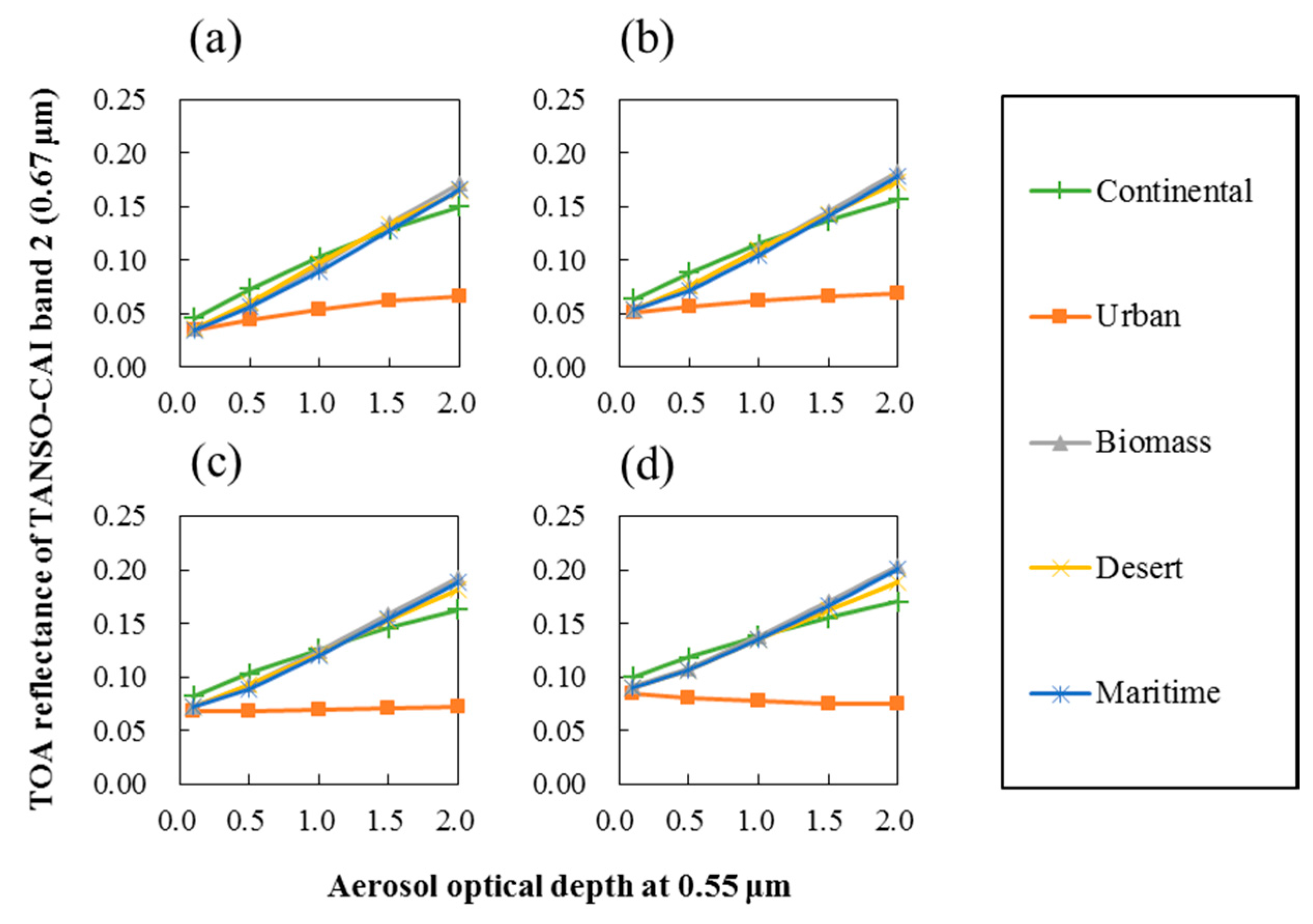
| Case Name | Solar Zenith (Degree) | Satellite Zenith (Degree) | Relative Azimuth (Degree) |
|---|---|---|---|
| a | 30 | 0 | 0 |
| b | 30 | 30 | 0 |
| c | 30 | 30 | 180 |
| d | 30 | 60 | 0 |
| e | 30 | 60 | 180 |
| f | 60 | 0 | 0 |
| g | 60 | 30 | 0 |
| h | 60 | 30 | 180 |
| i | 60 | 60 | 0 |
| j | 60 | 60 | 180 |
| Site Name | Longitude (Decimal Degrees) | Latitude (Decimal Degrees) | ELEVATION (Meters) | N | Mean AOD | r | RMSE | MBE | EE1 | EE2 |
|---|---|---|---|---|---|---|---|---|---|---|
| Vientiane | 102.57 | 17.99 | 170 | 28 | 0.716 | 0.921 | 0.141 | −0.059 | 78.6% | 82.1% |
| Xinglong | 117.58 | 40.40 | 970 | 19 | 0.164 | 0.791 | 0.136 | −0.110 | 31.6% | 73.7% |
| Dhaka_University | 90.40 | 23.73 | 34 | 31 | 0.915 | 0.855 | 0.328 | 0.245 | 41.9% | 51.6% |
| Chiang_Mai_Met_Sta | 98.97 | 18.77 | 312 | 26 | 0.520 | 0.974 | 0.140 | 0.099 | 61.5% | 73.1% |
| Ussuriysk | 132.16 | 43.70 | 280 | 13 | 0.249 | 0.904 | 0.119 | −0.089 | 38.5% | 69.2% |
| Total | 117 | 0.584 | 0.922 | 0.205 | 0.045 | 52.1% | 69.2% |
| +20 deg. (Forward Viewing) | −20 deg. (Backward Viewing) | ||||
|---|---|---|---|---|---|
| Band Number | Bandwidth (μm) | Spatial Resolution (m) | Band Number | Bandwidth (μm) | Spatial Resolution (m) |
| 1 | 0.333–0.353 | 460 | 6 | 0.370–0.390 | 460 |
| 2 | 0.433–0.453 | 460 | 7 | 0.540–0.560 | 460 |
| 3 | 0.664–0.684 | 460 | 8 | 0.664–0.684 | 460 |
| 4 | 0.859–0.879 | 460 | 9 | 0.859–0.879 | 460 |
| 5 | 1.585–1.675 | 920 | 10 | 1.585–1.675 | 920 |
© 2017 by the authors. Licensee MDPI, Basel, Switzerland. This article is an open access article distributed under the terms and conditions of the Creative Commons Attribution (CC BY) license (http://creativecommons.org/licenses/by/4.0/).
Share and Cite
Zhong, G.; Wang, X.; Guo, M.; Tani, H.; Chittenden, A.R.; Yin, S.; Sun, Z.; Matsumura, S. A Dark Target Algorithm for the GOSAT TANSO-CAI Sensor in Aerosol Optical Depth Retrieval over Land. Remote Sens. 2017, 9, 524. https://doi.org/10.3390/rs9060524
Zhong G, Wang X, Guo M, Tani H, Chittenden AR, Yin S, Sun Z, Matsumura S. A Dark Target Algorithm for the GOSAT TANSO-CAI Sensor in Aerosol Optical Depth Retrieval over Land. Remote Sensing. 2017; 9(6):524. https://doi.org/10.3390/rs9060524
Chicago/Turabian StyleZhong, Guosheng, Xiufeng Wang, Meng Guo, Hiroshi Tani, Anthony R. Chittenden, Shuai Yin, Zhongyi Sun, and Shinji Matsumura. 2017. "A Dark Target Algorithm for the GOSAT TANSO-CAI Sensor in Aerosol Optical Depth Retrieval over Land" Remote Sensing 9, no. 6: 524. https://doi.org/10.3390/rs9060524
APA StyleZhong, G., Wang, X., Guo, M., Tani, H., Chittenden, A. R., Yin, S., Sun, Z., & Matsumura, S. (2017). A Dark Target Algorithm for the GOSAT TANSO-CAI Sensor in Aerosol Optical Depth Retrieval over Land. Remote Sensing, 9(6), 524. https://doi.org/10.3390/rs9060524