Evaluation of the SBAS InSAR Service of the European Space Agency’s Geohazard Exploitation Platform (GEP)

 ,
,  ,
,  ,
,  , , ,
, , ,  ,
,  , ,
, , 
Abstract
1. Introduction
2. GEP, the G-POD Environment and the SBAS InSAR Service
3. Materials and Methods
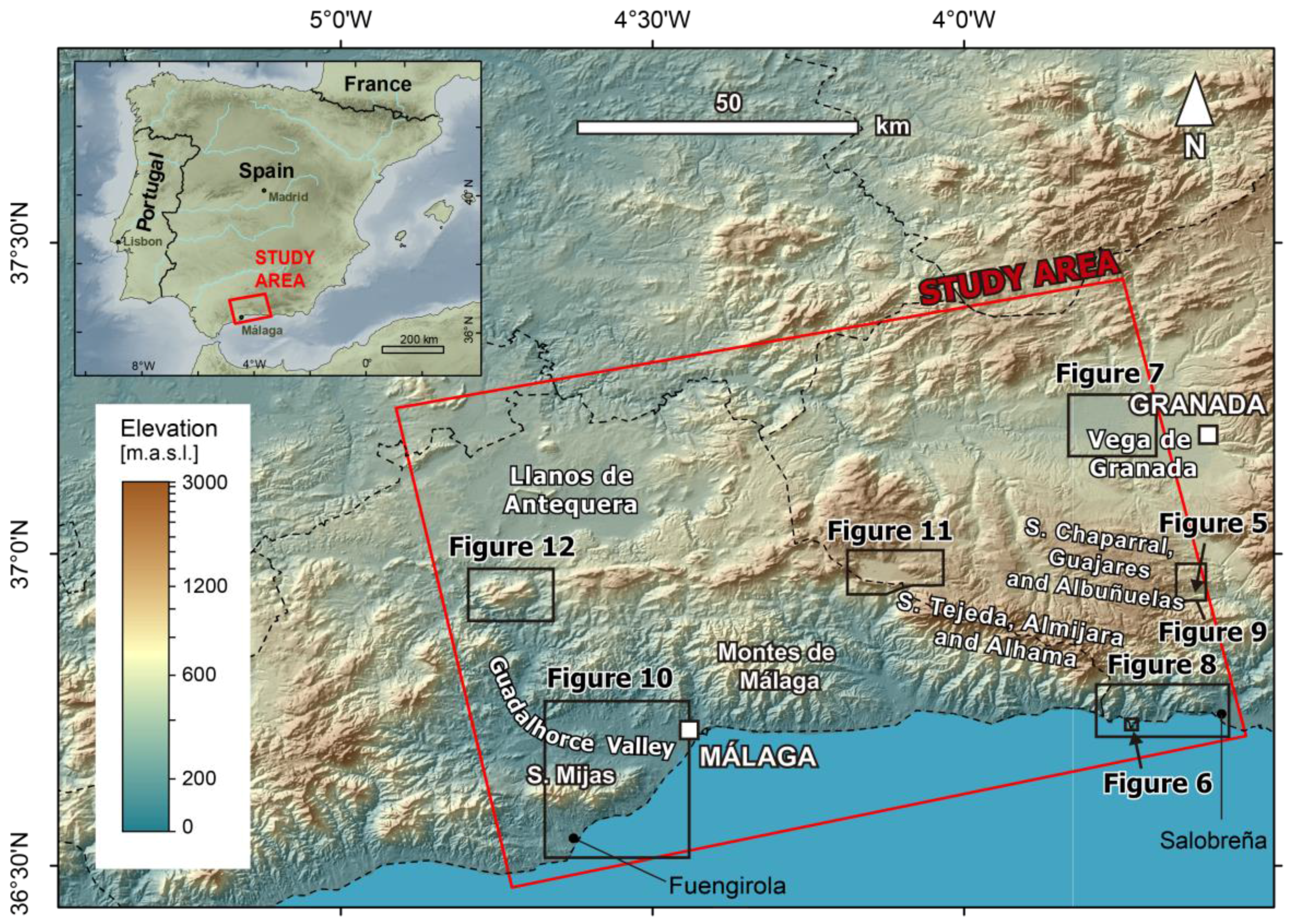
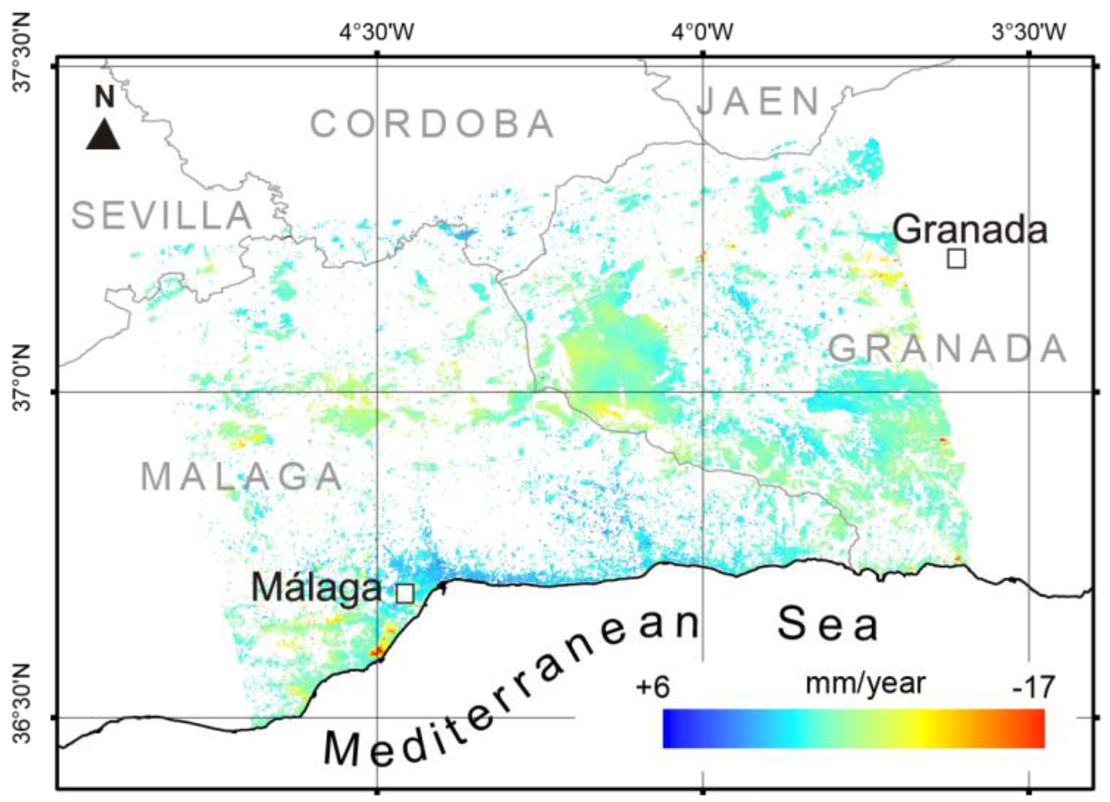
3.1. Study Area
3.2. SAR Data and Processing Methods
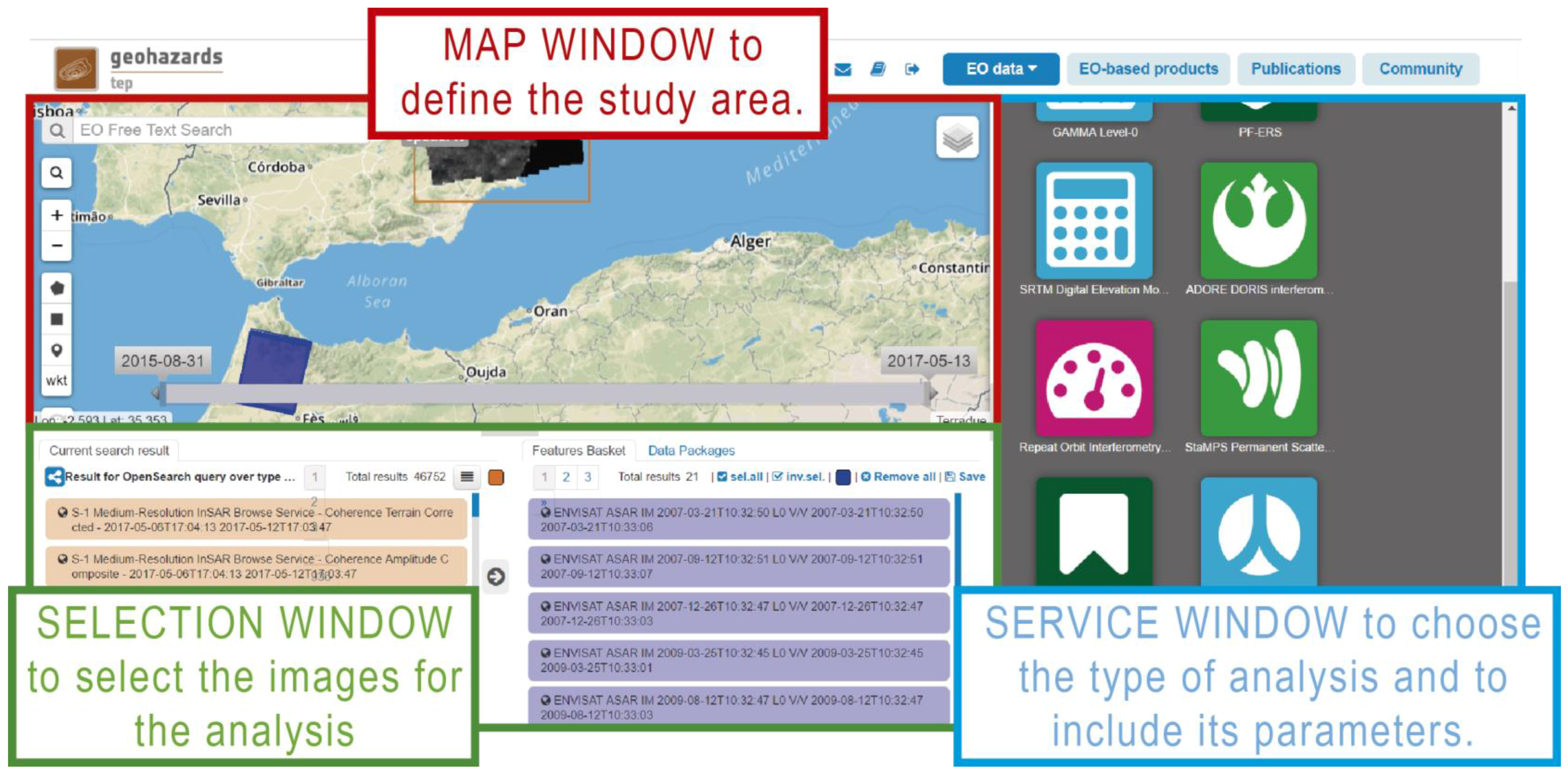
- Selection of the SBAS Service in the Service window. After you select the service, the window displays a form to be completed with the parameters of the DInSAR analysis.
- Selection the Area of Interest (AOI) in the Map window. By using the tools of the Map window you can draw a rectangle and the system shows you in the Selection window the available images coinciding with the chosen AOI.
- Selection of the images to include in the analysis. You can drag the images from the Selection window to the Service window.
- Completing the form. You can also select the reference point and include the extension of the analysis using the AOI in the Map window. The system also permits the modification of the input parameters implemented by default.
- Running the analysis.
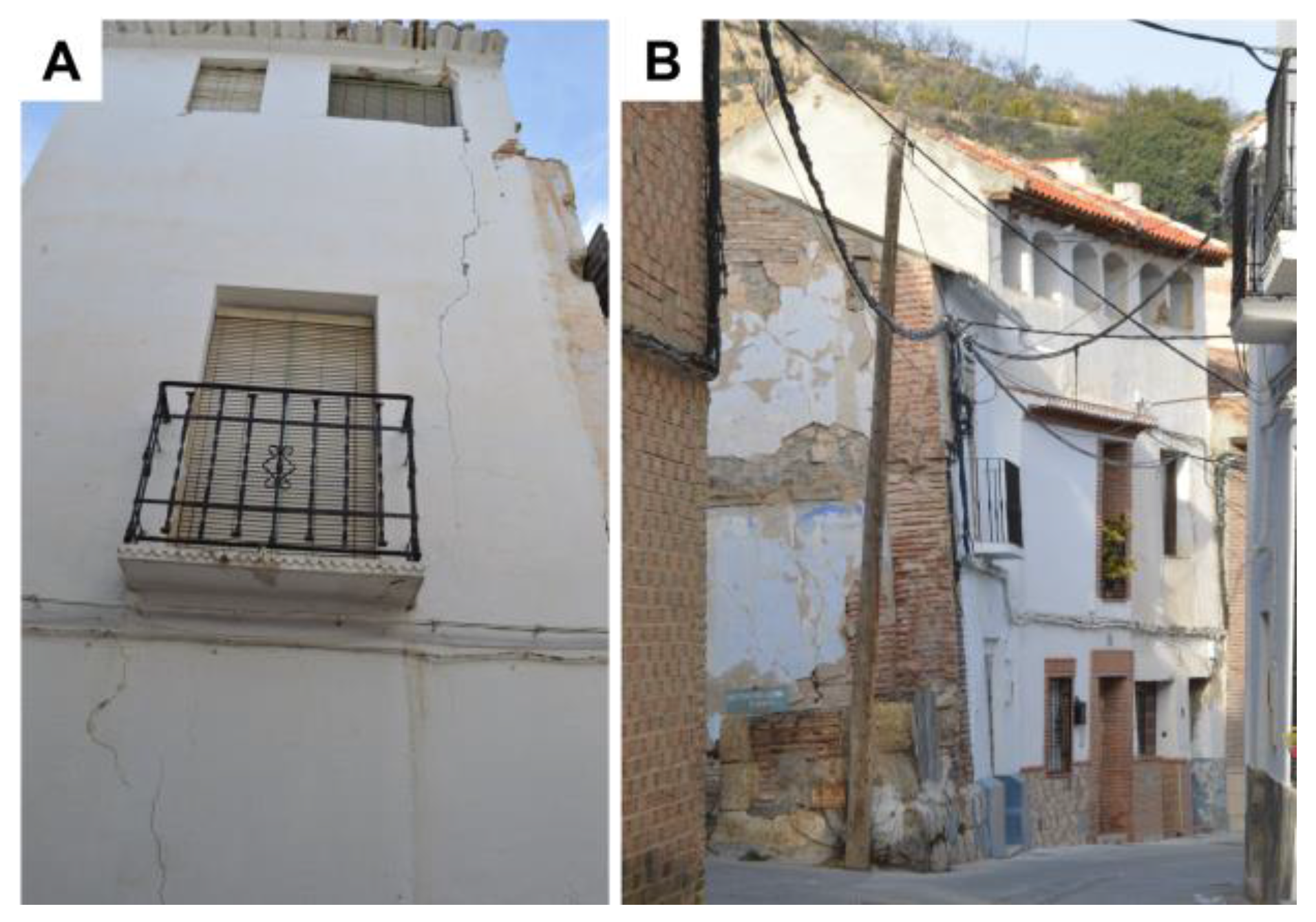
3.3. Interpretation of Unstable Points Detected
4. Results
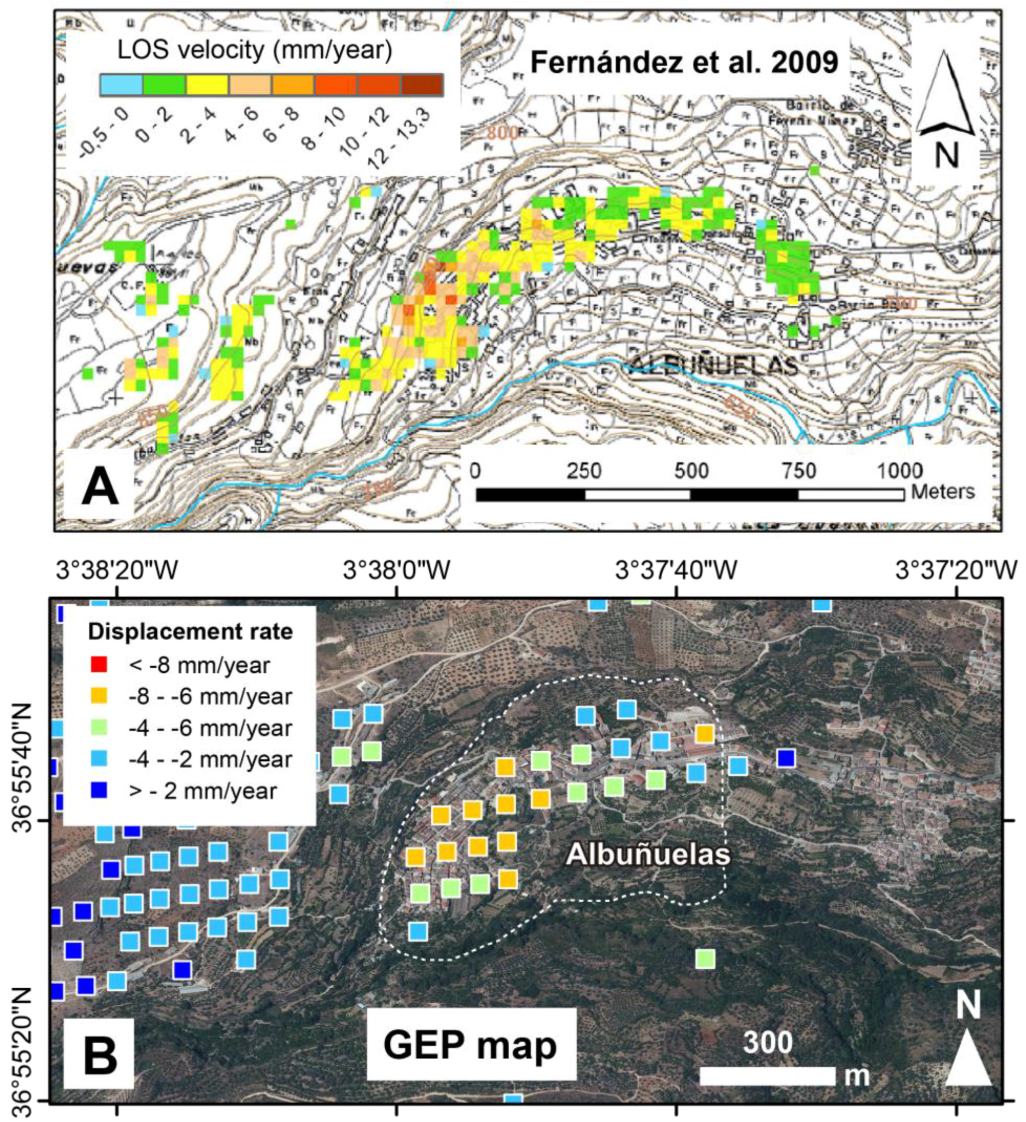
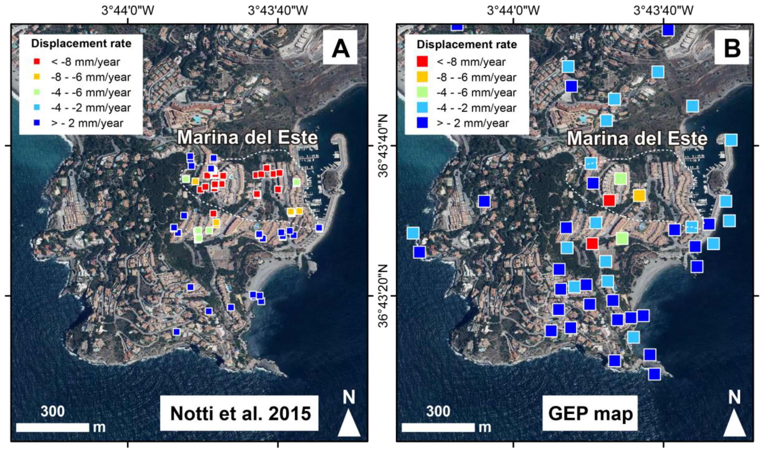
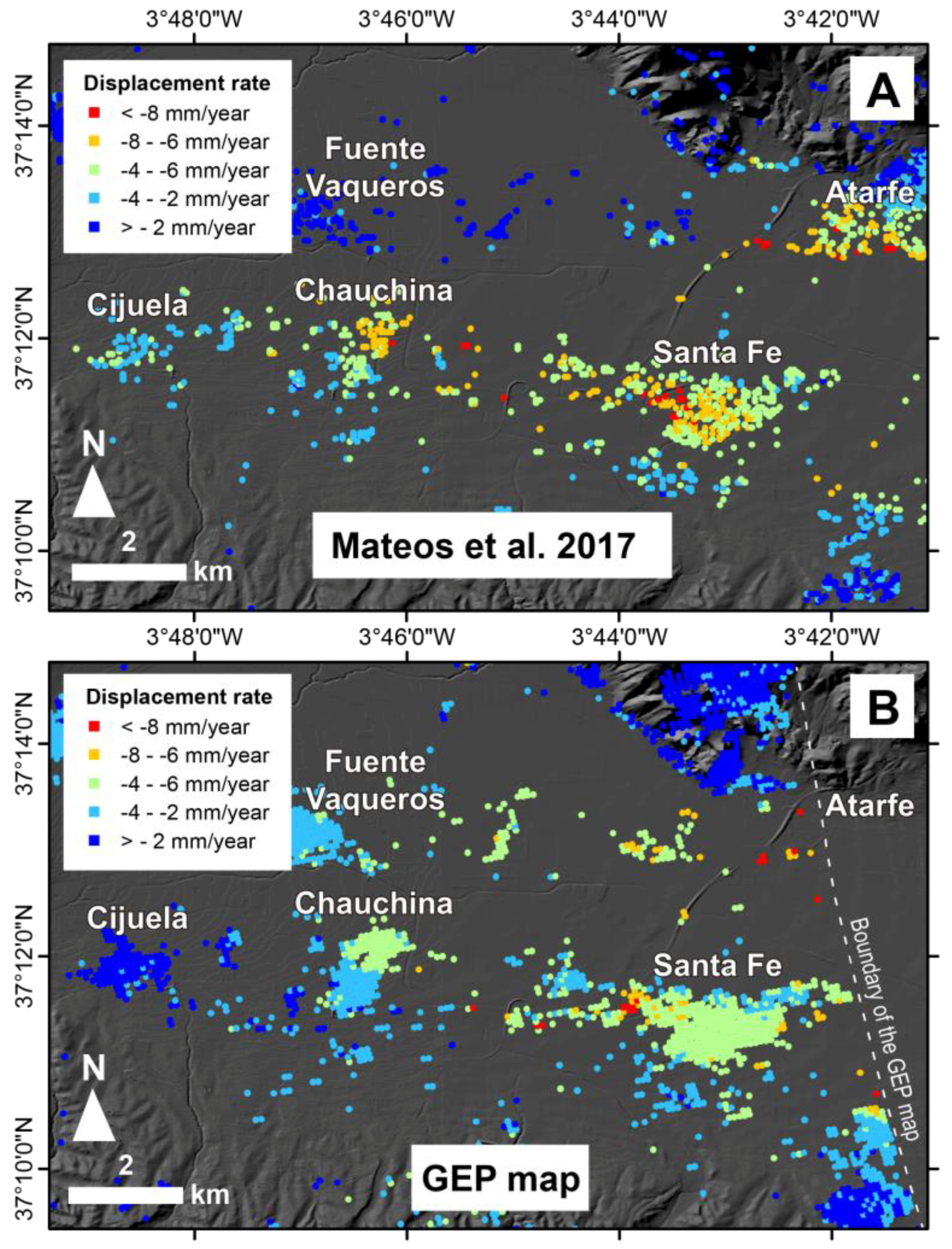
4.1. Comparison of GEP Results with Previous Data
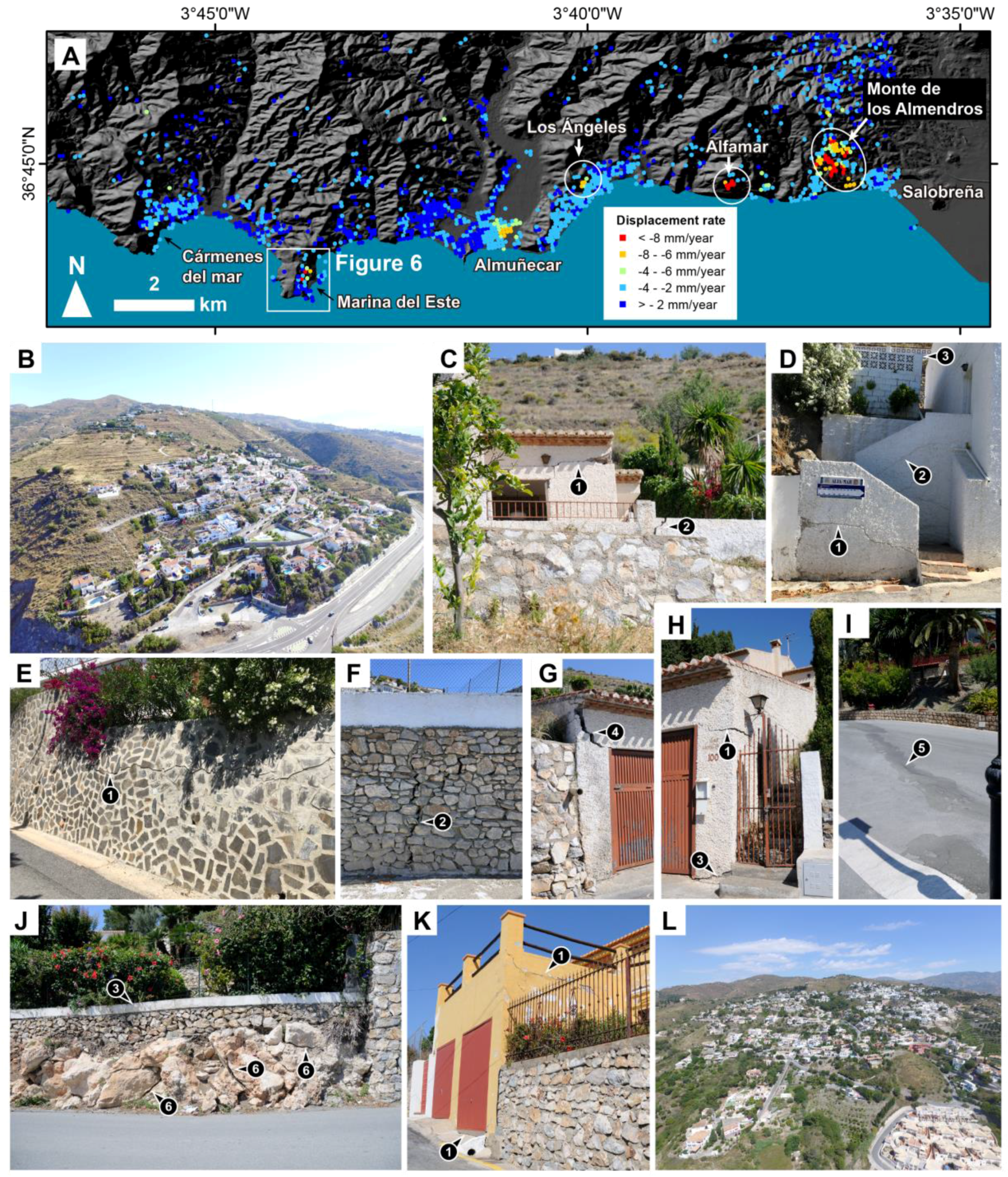
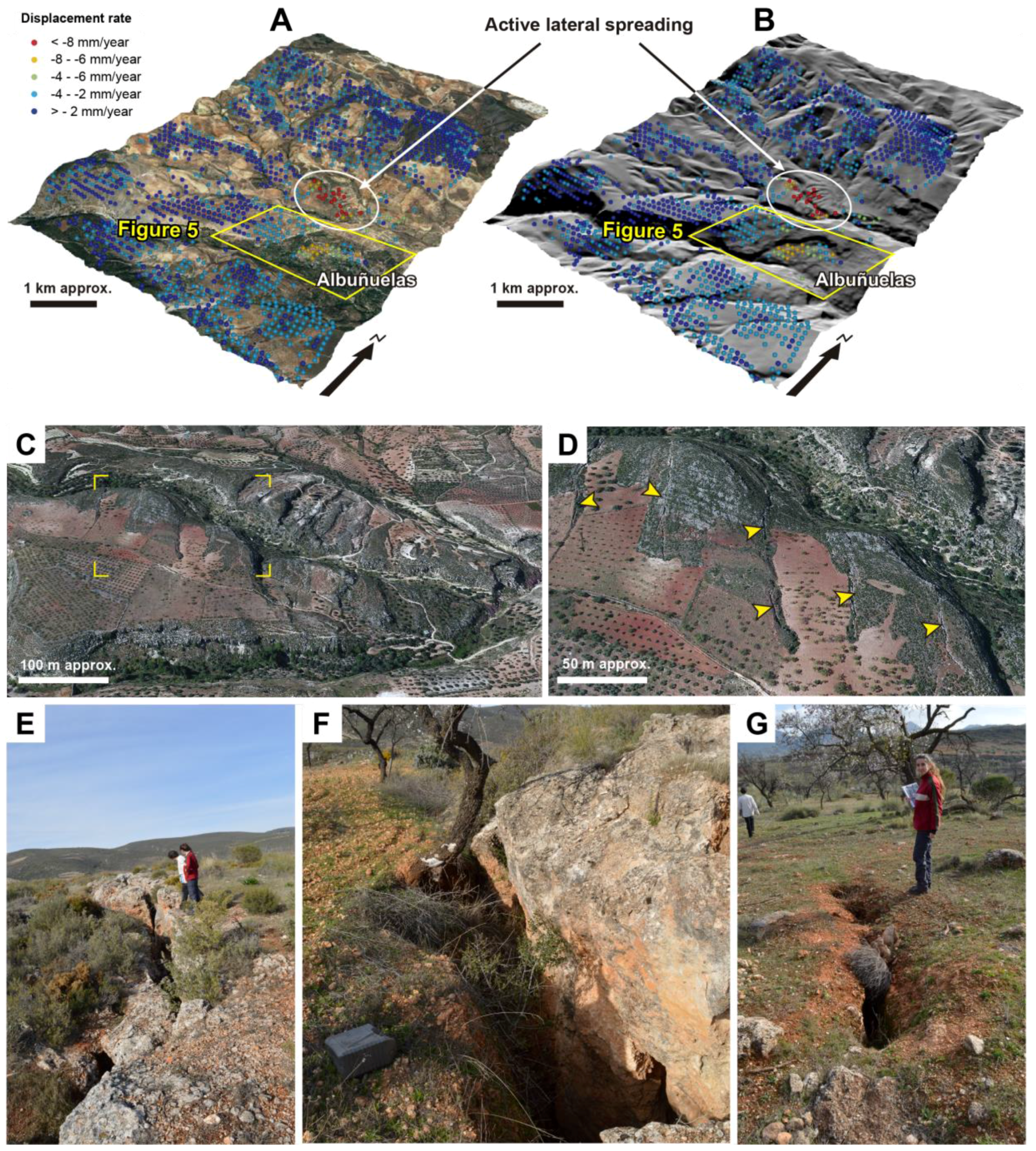
4.1.1. Movements Related to Slope Instabilities
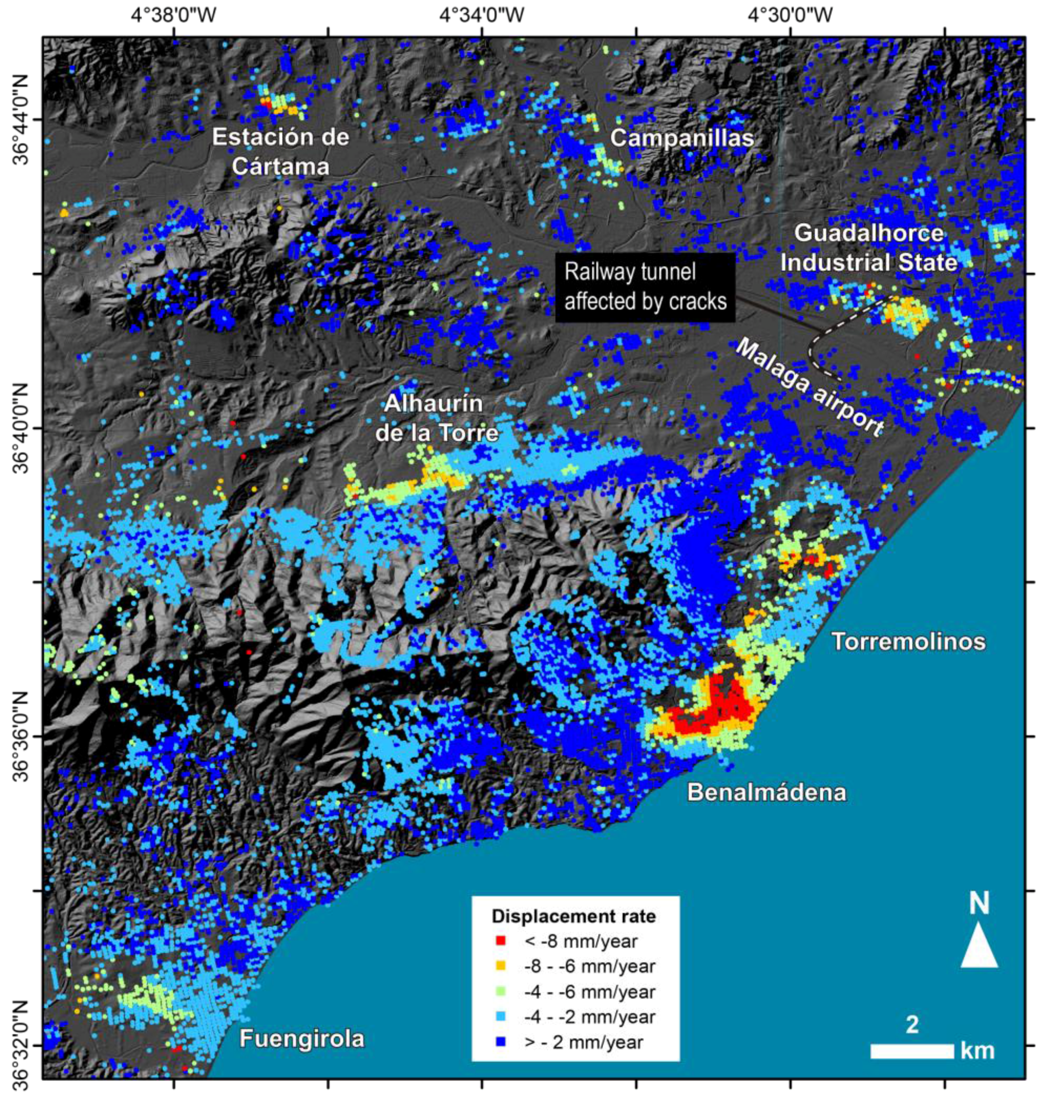
4.1.2. Movements Due to Groundwater Withdrawal
4.2. New Active Processes Detected with GEP
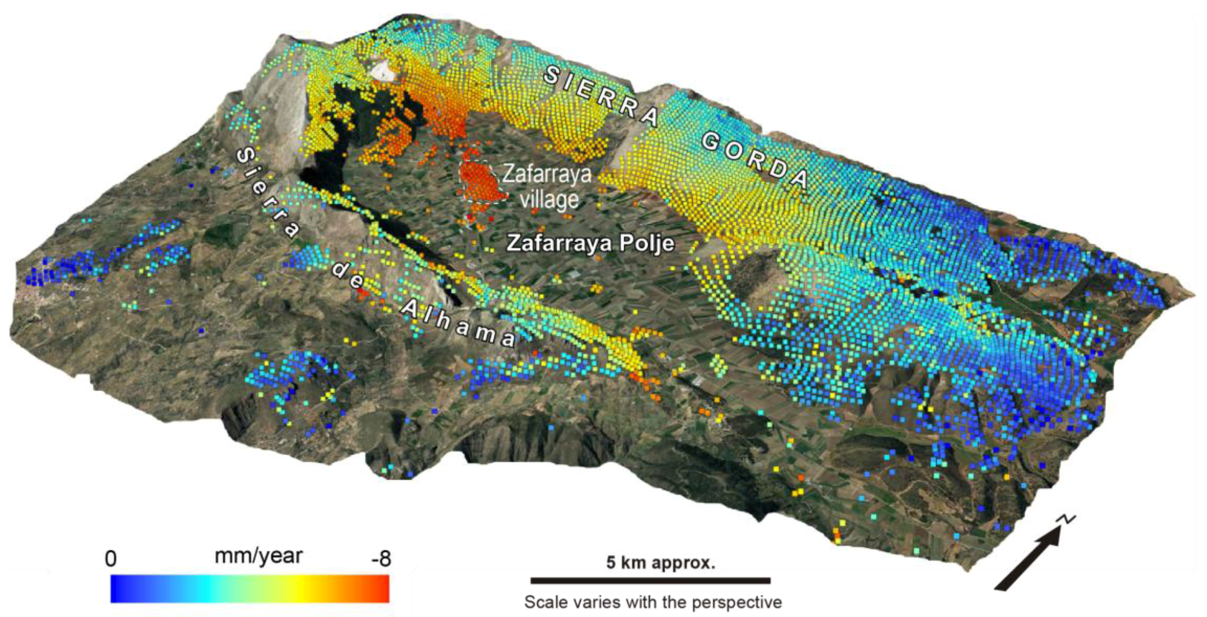
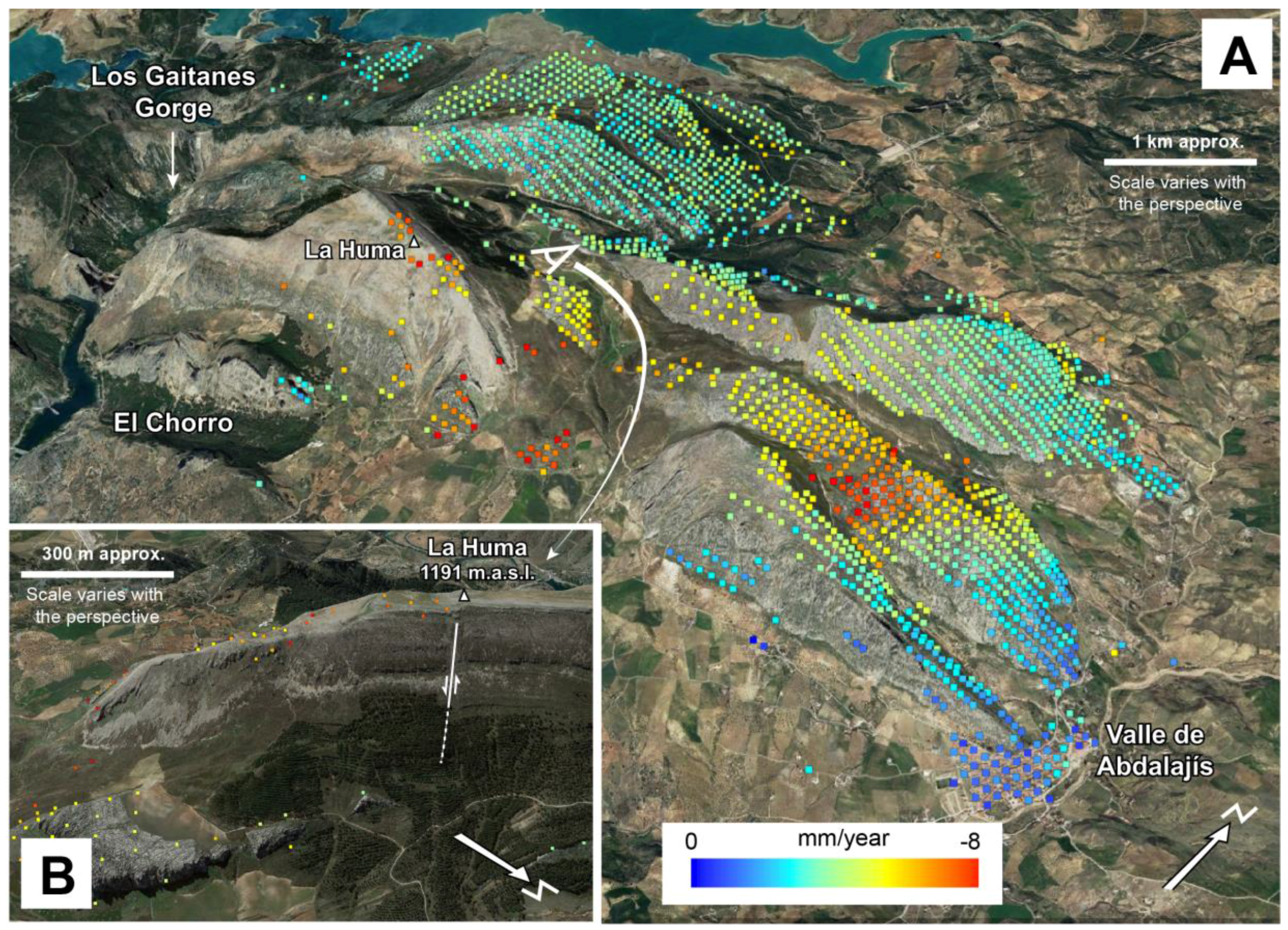
4.2.1. Deformation Related to Slope Instabilities
4.2.2. Deformation Due to Groundwater Withdrawal
4.3.2. Deformation of Unknown Nature
5. Discussion
5.1. Advantages and Limitations of Web-Based InSAR Processing Tools
5.2. Implications for the Hazard Analysis Community
6. Conclusions
Acknowledgments
Author Contributions
Conflicts of Interest
References
- Lash, R. Aerial archaeologist. Nature 2016, 534, 427. [Google Scholar] [CrossRef]
- Manunta, M.; Bonano, M.; Buonanno, S.; Casu, F.; De Luca, C.; Fusco, A.; Lanari, R.; Manzo, M.; Ojha, C.; Pepe, A.; et al. Unsupervised parallel SBAS-DInSAR chain for massive and systematic Sentinel-1 data processing. In Proceedings of the 2016 IEEE International Geoscience and Remote Sensing Symposium (IGARSS), Beijing, China, 10–15 July 2016; pp. 3890–3893. [Google Scholar]
- Massonnet, D.; Rossi, M.; Carmona, C.; Adragna, F.; Peltzer, G.; Feigl, K.; Rabaute, T. The displacement field of the Landers earthquake mapped by radar interferometry. Nature 1993, 364, 138–142. [Google Scholar] [CrossRef]
- Tomás, R.; Romero, R.; Mulas, J.; Marturià, J.J.; Mallorquí, J.J.; Lopez-Sanchez, J.M.; Herrera, G.; Gutiérrez, F.; González, P.J.; Fernández, J.; et al. Radar interferometry techniques for the study of ground subsidence phenomena: A review of practical issues through cases in Spain. Environ. Earth Sci. 2014, 71, 163–181. [Google Scholar] [CrossRef]
- Przylucka, M.; Herrera, G.; Graniczny, M.; Colombo, D.; Béjar-Pizarro, M. Combination of conventional and advanced DInSAR to monitor very fast mining subsidence with TerraSAR-X data: Bytom City (Poland). Remote Sens. 2015, 7, 5300–5328. [Google Scholar] [CrossRef]
- Galve, J.P.; Castañeda, C.; Gutiírrez, F.; Herrera, G. Assessing sinkhole activity in the Ebro Valley mantled evaporite karst using advanced DInSAR. Geomorphology 2015, 229, 30–44. [Google Scholar] [CrossRef]
- Galve, J.P.; Castañeda, C.; Gutiírrez, F. Railway deformation detected by DInSAR over active sinkholes in the Ebro Valley evaporite karst, Spain. Nat. Hazards Earth Syst. Sci. 2015, 15, 2439–2448. [Google Scholar] [CrossRef]
- Caló, F.; Notti, D.; Galve, J.P.; Abdikan, S.; Görüm, T.; Pepe, A.; Şanli, F.B. DInSAR-based detection of land subsidence and correlation with groundwater depletion in konya plain, Turkey. Remote Sens. 2017, 9, 83. [Google Scholar] [CrossRef]
- Herrera, G.; Gutiérrez, F.; García-Davalillo, J.C.; Guerrero, J.; Notti, D.; Galve, J.P.; Fernández-Merodo, J.A.; Cooksley, G. Multi-sensor advanced DInSAR monitoring of very slow landslides: The Tena Valley case study (Central Spanish Pyrenees). Remote Sens. Environ. 2013, 128, 31–43. [Google Scholar] [CrossRef]
- Wasowski, J.; Bovenga, F. Investigating landslides and unstable slopes with satellite Multi Temporal Interferometry: Current issues and future perspectives. Eng. Geol. 2014, 174, 103–138. [Google Scholar] [CrossRef]
- Solaro, G.; Acocella, V.; Pepe, S.; Ruch, J.; Neri, M.; Sansosti, E. Anatomy of an unstable volcano from InSAR: Multiple processes affecting flank instability at Mt. Etna, 1994–2008. J. Geophys. Res. Solid Earth 2010, 115, B10405. [Google Scholar] [CrossRef]
- Closson, D.; Karaki, N.A. Dikes stability monitoring versus sinkholes and subsidence, dead sea region, jordan. In Land Applications of Radar Remote Sensing; Closson, D., Ed.; InTech: Rijeka, Croatia, 2014; pp. 281–307. [Google Scholar]
- Biggs, J.; Ebmeier, S.K.; Aspinall, W.P.; Lu, Z.; Pritchard, M.E.; Sparks, R.S.J.; Mather, T.A. Global link between deformation and volcanic eruption quantified by satellite imagery. Nat. Commun. 2014, 5, 3471. [Google Scholar] [CrossRef] [PubMed]
- Closson, D.; Karaki, N.A.; Hansen, H.; Derauw, D.; Barbier, C.; Ozer, A. Space-borne radar interferometric mapping of precursory deformations of a dyke collapse, Dead Sea area, Jordan. Int. J. Remote Sens. 2003, 24, 843–849. [Google Scholar] [CrossRef]
- Nof, R.N.; Baer, G.; Ziv, A.; Raz, E.; Atzori, S.; Salvi, S. Sinkhole precursors along the Dead Sea, Israel, revealed by SAR interferometry. Geology 2013, 41, 1019–1022. [Google Scholar] [CrossRef]
- Castañeda, C.; Gutiérrez, F.; Manunta, M.; Galve, J.P. DInSAR measurements of ground deformation by sinkholes, mining subsidence, and landslides, Ebro River, Spain. Earth Surf. Process. Landf. 2009, 34, 1562–1574. [Google Scholar] [CrossRef]
- Palmer, J. Creeping earth could hold secret to deadly landslides. Nature 2017, 548, 384–386. [Google Scholar] [CrossRef] [PubMed]
- Notti, D.; Galve, J.P.; Mateos, R.M.; Monserrat, O.; Lamas-Fernández, F.; Fernández-Chacón, F.; Roldán-García, F.J.; Pérez-Peña, J.V.; Crosetto, M.; Azañón, J.M. Human-induced coastal landslide reactivation. Monitoring by PSInSAR techniques and urban damage survey (SE Spain). Landslides 2015, 12, 1007–1014. [Google Scholar] [CrossRef]
- Notti, D.; Mateos, R.M.; Monserrat, O.; Devanthéry, N.; Peinado, T.; Roldán, F.J.; Fernández-Chacón, F.; Galve, J.P.; Lamas, F.; Azañón, J.M. Lithological control of land subsidence induced by groundwater withdrawal in new urban areas (Granada Basin, SE Spain). Multiband DInSAR monitoring. Hydrol. Process. 2016, 30, 2317–2331. [Google Scholar] [CrossRef]
- Mateos, R.M.; Azañón, J.M.; Roldán, F.J.; Notti, D.; Pérez-Peña, V.; Galve, J.P.; Pérez-García, J.L.; Colomo, C.M.; Gómez-López, J.M.; Montserrat, O.; et al. The combined use of PSInSAR and UAV photogrammetry techniques for the analysis of the kinematics of a coastal landslide affecting an urban area (SE Spain). Landslides 2017, 14, 743–754. [Google Scholar] [CrossRef]
- Mateos, R.M.; Ezquerro, P.; Luque-Espinar, J.A.; Béjar-Pizarro, M.; Notti, D.; Azañón, J.M.; Montserrat, O.; Herrera, G.; Fernández-Chacón, F.; Peinado, T.; et al. Multiband PSInSAR and long-period monitoring of land subsidence in a strategic detrital aquifer (Vega de Granada, SE Spain): An approach to support management decisions. J. Hydrol. 2017, 553, 71–87. [Google Scholar] [CrossRef]
- Albano, M.; Polcari, M.; Bignami, C.; Moro, M.; Saroli, M.; Stramondo, S. An innovative procedure for monitoring the change in soil seismic response by InSAR data: Application to the Mexico City subsidence. Int. J. Appl. Earth Obs. Geoinf. 2016, 53, 146–158. [Google Scholar] [CrossRef]
- Casu, F.; Elefante, S.; Imperatore, P.; Zinno, I.; Manunta, M.; De Luca, C.; Lanari, R. SBAS-DInSAR parallel processing for deformation time-series computation. IEEE J. Sel. Top. Appl. Earth Obs. Remote Sens. 2014, 7, 3285–3296. [Google Scholar] [CrossRef]
- De Luca, C.; Cuccu, R.; Elefante, S.; Zinno, I.; Manunta, M.; Casola, V.; Rivolta, G.; Lanari, R.; Casu, F. An on-demand web tool for the unsupervised retrieval of earth’s surface deformation from SAR data: The P-SBAS service within the ESA G-POD environment. Remote Sens. 2015, 7, 15630–15650. [Google Scholar] [CrossRef]
- Berardino, P.; Fornaro, G.; Lanari, R.; Sansosti, E.; Mora, O.; Lanari, R.; Mallorqui, J.J.; Berardino, P.; Sansosti, E. A new algorithm for surface deformation monitoring based on small baseline differential SAR interferograms. IEEE Trans. Geosci. Remote Sens. 2002, 40, 2375–2383. [Google Scholar] [CrossRef]
- Guzzetti, F.; Manunta, M.; Ardizzone, F.; Pepe, A.; Cardinali, M.; Zeni, G.; Reichenbach, P.; Lanari, R. Analysis of ground deformation detected using the SBAS-DInSAR technique in Umbria, Central Italy. Pure Appl. Geophys. 2009, 166, 1425–1459. [Google Scholar] [CrossRef]
- Lanari, R.; Berardino, P.; Bonano, M.; Casu, F.; Manconi, A.; Manunta, M.; Manzo, M.; Pepe, A.; Pepe, S.; Sansosti, E.; et al. Surface displacements associated with the L’Aquila 2009 Mw 6.3 earthquake (central Italy): New evidence from SBAS-DInSAR time series analysis. Geophys. Res. Lett. 2010, 37, 10–15. [Google Scholar] [CrossRef]
- Del Ventisette, C.; Ciampalini, A.; Manunta, M.; Caló, F.; Paglia, L.; Ardizzone, F.; Mondini, A.C.; Reichenbach, P.; Mateos, R.M.; Bianchini, S.; et al. Exploitation of large archives of ERS and ENVISAT C-band SAR data to characterize ground deformations. Remote Sens. 2013, 5, 3896–3917. [Google Scholar] [CrossRef]
- Fiaschi, S.; Closson, D.; Abou Karaki, N.; Pasquali, P.; Riccardi, P.; Floris, M. The complex karst dynamics of the Lisan Peninsula revealed by 25 years of DInSAR observations. Dead Sea, Jordan. ISPRS J. Photogramm. Remote Sens. 2017, 130, 358–369. [Google Scholar] [CrossRef]
- Chacón, J.; Irigaray, T.; Fernández, T. Los movimientos de ladera de la provincia de Granada. In Atlas de Riesgos Naturales en la Provincia de Granada; Ferrer, M., Ed.; Diputación de Granada-Instituto Geológico y Minero de España (IGME): Granada, Spain, 2007; pp. 45–82. [Google Scholar]
- Fernandez, P.; Irigaray, C.; Jimenez, J.; El Hamdouni, R.; Crosetto, M.; Monserrat, O.; Chacon, J. First delimitation of areas affected by ground deformations in the Guadalfeo River Valley and Granada metropolitan area (Spain) using the DInSAR technique. Eng. Geol. 2009, 105, 84–101. [Google Scholar] [CrossRef]
- Sousa, J.J.; Ruiz, A.M.; Hanssen, R.F.; Bastos, L.; Gil, A.J.; Galindo-Zaldívar, J.; Sanz de Galdeano, C. PS-InSAR processing methodologies in the detection of field surface deformation-Study of the Granada basin (Central Betic Cordilleras, southern Spain). J. Geodyn. 2010, 49, 181–189. [Google Scholar] [CrossRef]
- Ruiz, A.M.; Caro Cuenca, M.; Sousa, J.J.; Gil, A.J.; Hanssen, R.F.; Perski, Z.; Galindo-Zaldívar, J.; Sanz de Galdeano, C. Land subsidence monitoring in the southern Spanish coast using satellite radar interferometry. In Proceedings of the FRINGE 2011, Frascati, Italy, 19–23 September 2011; pp. 19–23. [Google Scholar]
- Meisina, C.; Zucca, F.; Notti, D.; Colombo, A.; Cucchi, A.; Savio, G.; Giannico, C.; Bianchi, M. Geological interpretation of PSInSAR Data at regional scale. Sensors 2008, 8, 7469–7492. [Google Scholar] [CrossRef] [PubMed]
- Bianchini, S.; Herrera, G.; Mateos, R.M.; Notti, D.; Garcia, I.; Mora, O.; Moretti, S. Landslide activity maps generation by means of persistent scatterer interferometry. Remote Sens. 2013, 5, 6198–6222. [Google Scholar] [CrossRef]
- Irigaray, C.; Chacón, J. Los movimentos de ladera en el sector de Colmenar (Málaga). Revista de la Sociedad Geológica de España 1991, 4, 203–214. [Google Scholar]
- Biescas, E.; Crosetto, M.; Agudo, M.; Monserrat, O.; Crippa, B. Two Radar Interferometric Approaches to Monitor Slow and Fast Land Deformation. J. Surv. Eng. 2007, 133, 66–71. [Google Scholar] [CrossRef]
- Crosetto, M.; Monserrat, O.; Cuevas, M.; Crippa, B. Spaceborne differential SAR interferometry: Data analysis tools for deformation measurement. Remote Sens. 2011, 3, 305–318. [Google Scholar] [CrossRef]
- Béjar-Pizarro, M.; Guardiola-Albert, C.; García-Cárdenas, R.P.; Herrera, G.; Barra, A.; Molina, A.L.; Tessitore, S.; Staller, A.; Ortega-Becerril, J.A.; García-García, R.P. Interpolation of GPS and geological data using InSAR deformation maps: Method and application to land subsidence in the alto guadalentín aquifer (SE Spain). Remote Sens. 2016, 8, 965. [Google Scholar] [CrossRef]
- Tessitore, S.; Fernández-Merodo, J.A.; Herrera, G.; Tomás, R.; Ramondini, M.; Sanabria, M.; Duro, J.; Mulas, J.; Calcaterra, D. Comparison of water-level, extensometric, DInSAR and simulation data for quantification of subsidence in Murcia City (SE Spain). Hydrogeol. J. 2016, 24, 727–747. [Google Scholar] [CrossRef]
- Devanthéry, N.; Crosetto, M.; Monserrat, O.; Cuevas-González, M.; Crippa, B. An approach to persistent scatterer interferometry. Remote Sens. 2014, 6, 6662–6679. [Google Scholar] [CrossRef]
- Chacón, J.; Hamdouni, R.E.L.; Irigaray, C.; Jiménez-perálvarez, J.; Fernández, P.; Fernández, T.; Alameda, P.; Antonio, J.; Moya, J. Movimientos de ladera en la Costa de Almuñécar y su entorno. Geogaceta 2016, 59, 87–90. [Google Scholar]
- Hooper, A.J. A multi-temporal InSAR method incorporating both persistent scatterer and small baseline approaches. Geophys. Res. Lett. 2008, 35, 1–5. [Google Scholar] [CrossRef]
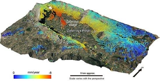
- Sanz de Galdeano, C. The Zafarraya Polje (Betic Cordillera, Granada, Spain), a basin open by lateral displacement and bending. J. Geodyn. 2013, 64, 62–70. [Google Scholar] [CrossRef]
- Ruiz-Armenteros, A.M.; Delgado, J.M.; Sousa, J.J.; Hanssen, R.F.; Caro, M.; Gil, A.J.; Galindo-Zaldívar, J.; De Galdeano, C.S. Deformation monitoring in Zafarraya fault and Sierra Tejeda antiform (Betic cordillera, Spain) using satellite radar interferometry. In Proceedings of the FRINGE’15: Advances in the Science and Applications of SAR Interferometry and Sentinel-1 InSAR Workshop, Frascati, Italy, 23–27 March 2015; ESA Publication: Paris, France, 2015. [Google Scholar]
- Delgado, J.; Vicente, F.; García-Tortosa, F.; Alfaro, P.; Estévez, A.; Lopez-Sanchez, J.M.; Tomás, R.; Mallorquí, J.J. A deep seated compound rotational rock slide and rock spread in SE Spain: Structural control and DInSAR monitoring. Geomorphology 2011, 129, 252–262. [Google Scholar] [CrossRef]
- Gutierrez, F.; Linares, R.; Roque, C.; Zarroca, M.; Rosell, J.; Galve, J.P.; Carbonel, D. Investigating gravitational grabens related to lateral spreading and evaporite dissolution subsidence by means of detailed mapping, trenching, and electrical resistivity tomography (Spanish Pyrenees). Lithosphere 2012, 4, 331. [Google Scholar] [CrossRef]
- Carbonel, D.; Gutiérrez, F.; Linares, R.; Roqué, C.; Zarroca, M.; McCalpin, J.; Guerrero, J.; Rodríguez, V. Differentiating between gravitational and tectonic faults by means of geomorphological mapping, trenching and geophysical surveys. The case of the Zenzano Fault (Iberian Chain, N Spain). Geomorphology 2013, 189, 93–108. [Google Scholar] [CrossRef]
- Crosetto, M.; Monserrat, O.; Cuevas-González, M.; Devanthéry, N.; Crippa, B. Persistent Scatterer Interferometry: A review. ISPRS J. Photogramm. Remote Sens. 2016, 115, 78–89. [Google Scholar] [CrossRef]
- Lu, P.; Bai, S.; Casagli, N. Investigating spatial patterns of persistent scatterer interferometry point targets and landslide occurrences in the Arno River basin. Remote Sens. 2014, 6, 6817–6843. [Google Scholar] [CrossRef]
- Chaussard, E.; Bürgmann, R.; Fattahi, H.; Nadeau, R.M.; Taira, T.; Johnson, C.W.; Johanson, I. Potential for larger earthquakes in the East San Francisco Bay Area due to the direct connection between the Hayward and Calaveras Faults. Geophys. Res. Lett. 2015, 42, 2734–2741. [Google Scholar] [CrossRef]


| SAR Acquisition | ||
| Band/Polarisation | C/VV | |
| Wavelength (cm) | 5.6 | |
| Incidence angle | 23 | |
| Revisiting period (days) | 35 | |
| Orbital track/Frame | 459/731 | |
| Acquisition geometry | Ascending | |
| Pixel size (m) radar geometry | 4 × 10 | |
| SAR processing | ||
| Number of SAR images | 25 | |
| Temporal span | March 2003/August 2008 (5.3 years) | |
| Number of interferograms | 70 | |
| Bounding box (Lat, Long, proj.WGS84) | 36.49, −4.636/36.851, −3.557 | |
| Reference point coord (Lat, Long; proj.WGS84) | 36.78, −4.1 | |
| Processing mode | Multi-Temporal DInSAR Analysis | |
| Max Perpendicular Baseline (m) | 400 | |
| Max Temporal Baseline (days) | 1500 | |
| Ground Pixel Dimension (m) | 80 | |
| Max Allowed Delta-Doppler (Hz) | 1000 | |
| Max Allowed Doppler Centroid (Hz) | 2000 | |
| Goldstein Weight | 0.5 | |
| Coherence threshold | 0.7 | |
| APS Smoothing Time Window (days) | 200 | |
| Surface velocity map | ||
| Area (km2) | 9130 | |
| No. of measurement points | 155,474 | |
| Density of measurement points (points/km2) | 17 | |
| LOS displacement rate (mm/year) | ||
| Mean | −2 | |
| Maximum | +6 | |
| Minimum | −17 | |
| Standard deviation | 1 | |
| Cumulative LOS displacement (mm) | ||
| Mean | -4 | |
| Maximum | +50 | |
| Minimum | −92 | |
| Standard deviation | 7 | |
| Site | Satelite | Temporal Span | Technique | Reference |
|---|---|---|---|---|
| Albuñuelas | ERS1/2 | June/1993–December/2000 | Small-Area PSI approach | Fernández et al., 2009 |
| Marina del Este | ENVISAT | May/2003–December/2009 | Small-Area PSI approach | Notti et al., 2015 |
| Vega de Granada | ENVISAT | May/2003–December/2009 | PSIG Cousins analysis | Mateos et al., 2017 |
© 2017 by the authors. Licensee MDPI, Basel, Switzerland. This article is an open access article distributed under the terms and conditions of the Creative Commons Attribution (CC BY) license (http://creativecommons.org/licenses/by/4.0/).
Share and Cite
Galve, J.P.; Pérez-Peña, J.V.; Azañón, J.M.; Closson, D.; Caló, F.; Reyes-Carmona, C.; Jabaloy, A.; Ruano, P.; Mateos, R.M.; Notti, D.; et al. Evaluation of the SBAS InSAR Service of the European Space Agency’s Geohazard Exploitation Platform (GEP). Remote Sens. 2017, 9, 1291. https://doi.org/10.3390/rs9121291
Galve JP, Pérez-Peña JV, Azañón JM, Closson D, Caló F, Reyes-Carmona C, Jabaloy A, Ruano P, Mateos RM, Notti D, et al. Evaluation of the SBAS InSAR Service of the European Space Agency’s Geohazard Exploitation Platform (GEP). Remote Sensing. 2017; 9(12):1291. https://doi.org/10.3390/rs9121291
Chicago/Turabian StyleGalve, Jorge Pedro, José Vicente Pérez-Peña, José Miguel Azañón, Damien Closson, Fabiana Caló, Cristina Reyes-Carmona, Antonio Jabaloy, Patricia Ruano, Rosa María Mateos, Davide Notti, and et al. 2017. "Evaluation of the SBAS InSAR Service of the European Space Agency’s Geohazard Exploitation Platform (GEP)" Remote Sensing 9, no. 12: 1291. https://doi.org/10.3390/rs9121291
APA StyleGalve, J. P., Pérez-Peña, J. V., Azañón, J. M., Closson, D., Caló, F., Reyes-Carmona, C., Jabaloy, A., Ruano, P., Mateos, R. M., Notti, D., Herrera, G., Béjar-Pizarro, M., Monserrat, O., & Bally, P. (2017). Evaluation of the SBAS InSAR Service of the European Space Agency’s Geohazard Exploitation Platform (GEP). Remote Sensing, 9(12), 1291. https://doi.org/10.3390/rs9121291