Land-Air Interactions over Urban-Rural Transects Using Satellite Observations: Analysis over Delhi, India from 1991–2016

Abstract
:
1. Introduction
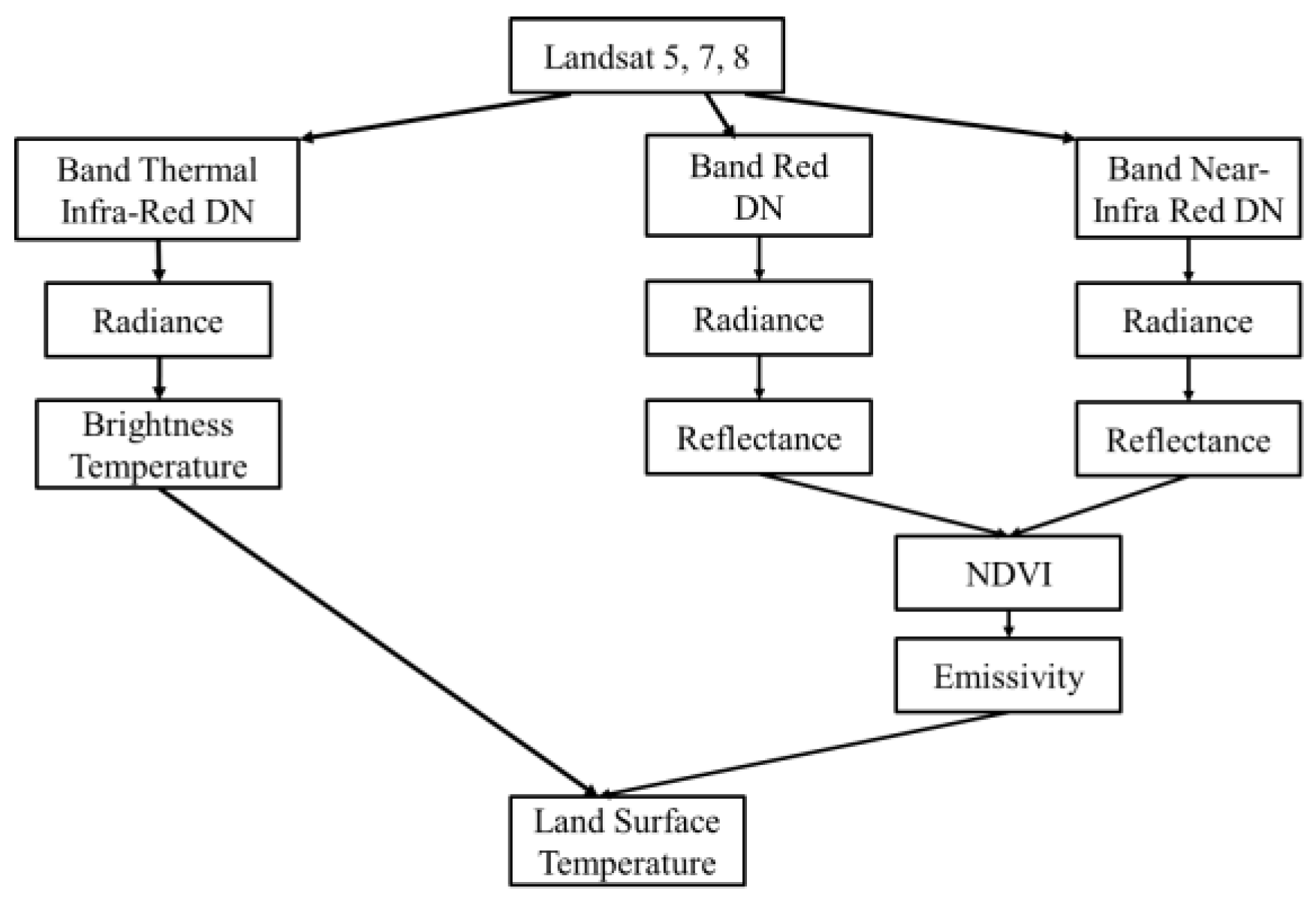
2. Materials and Methods
3. Results and Discussion
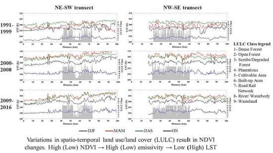
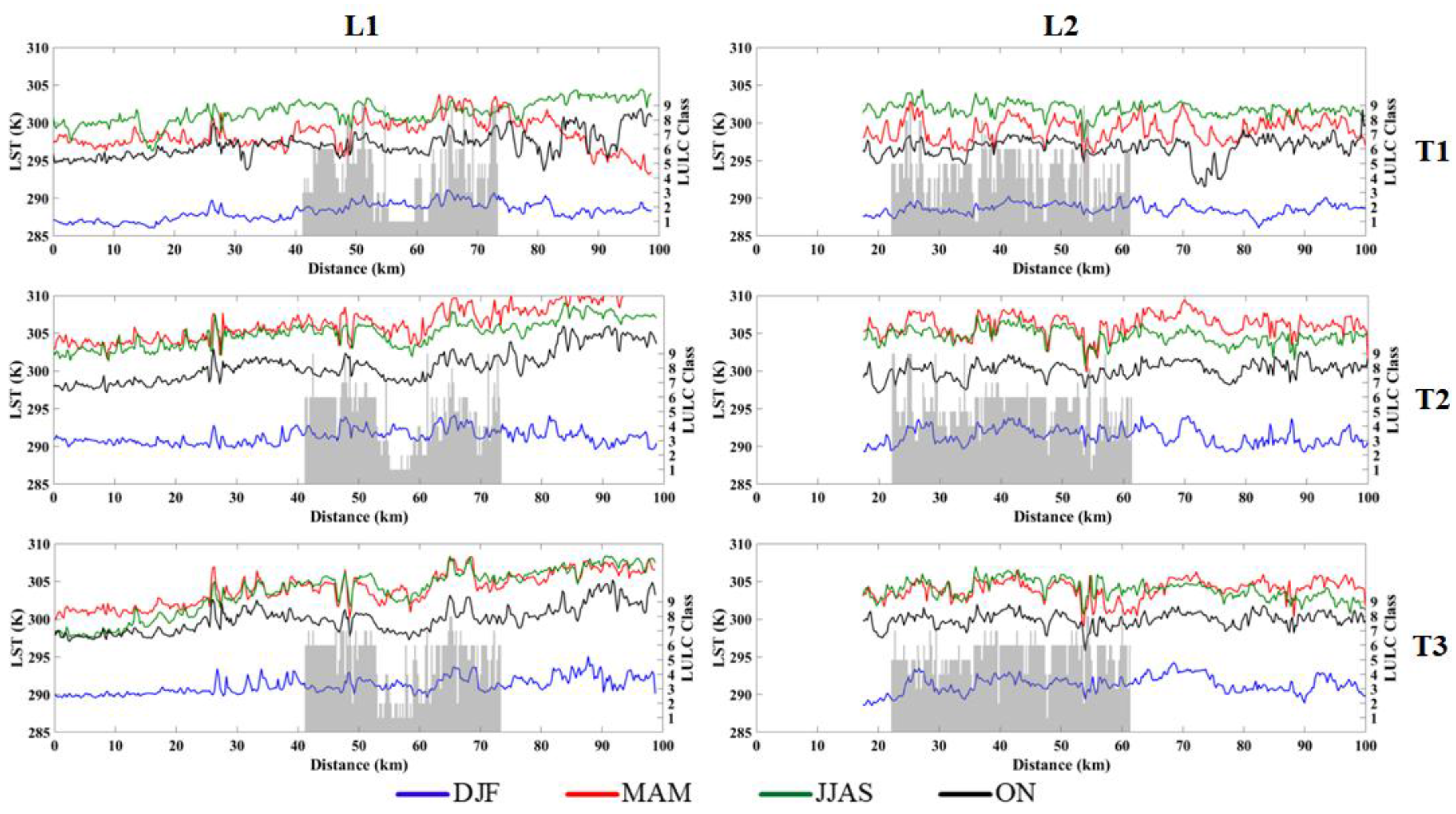
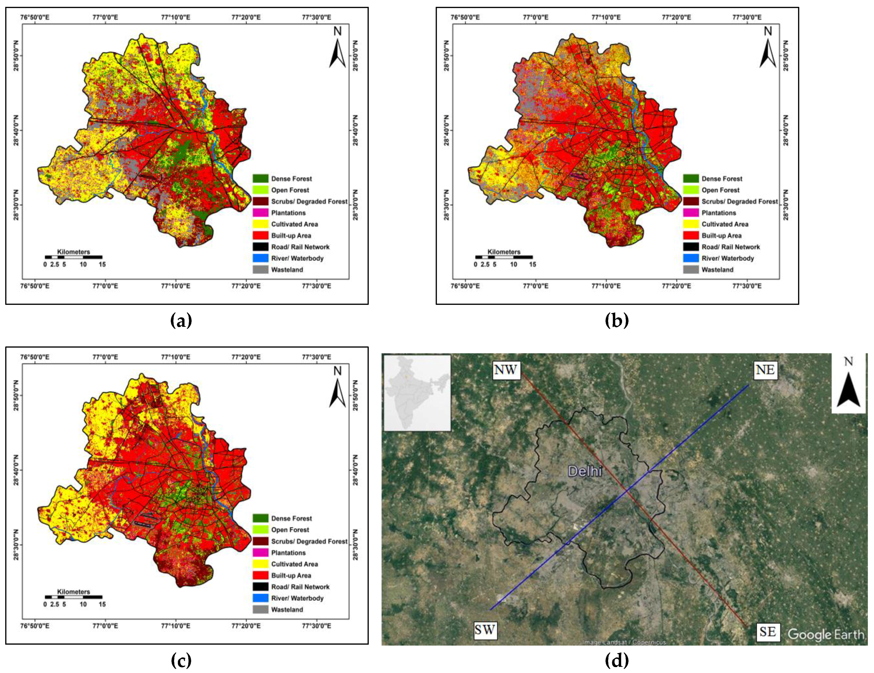
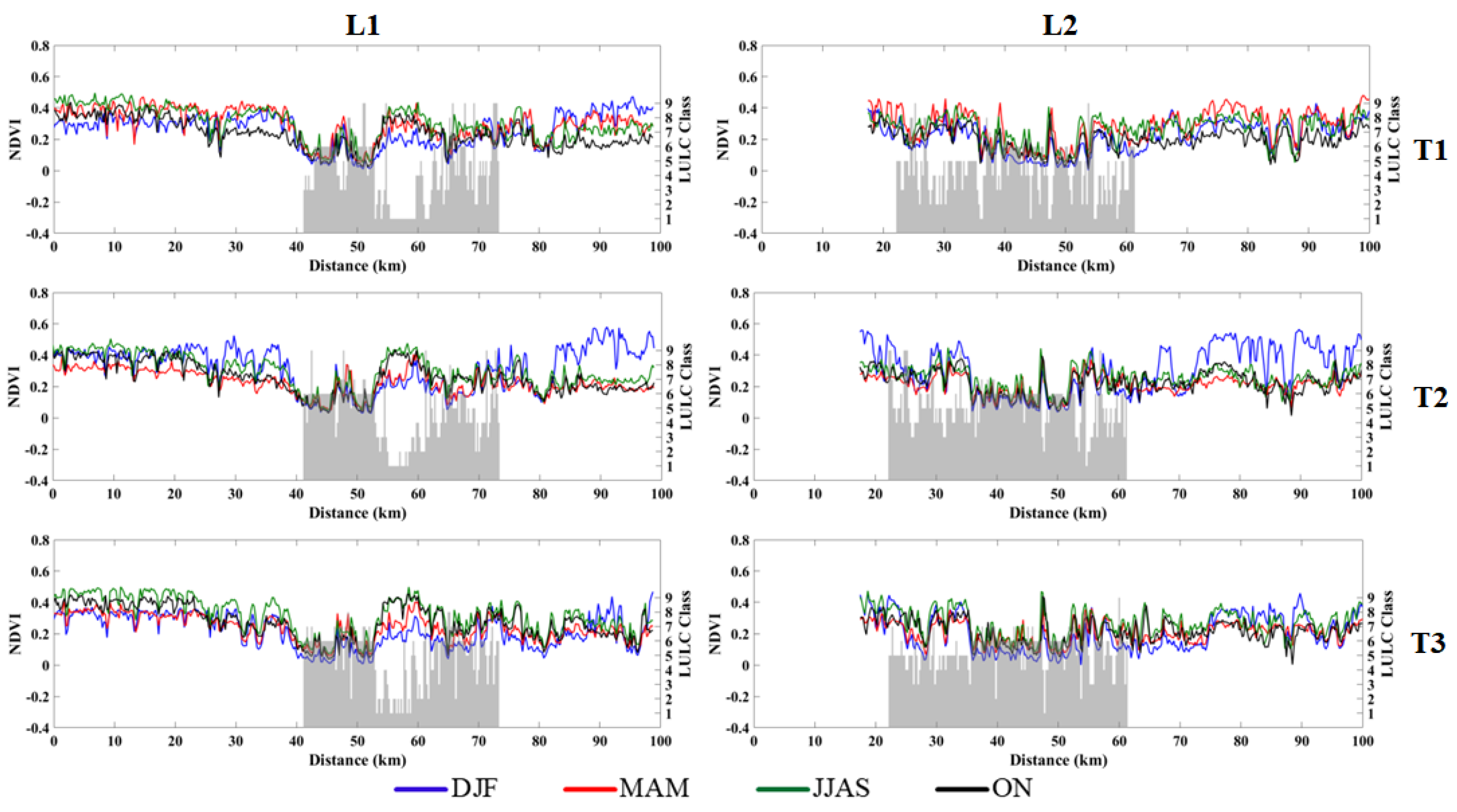
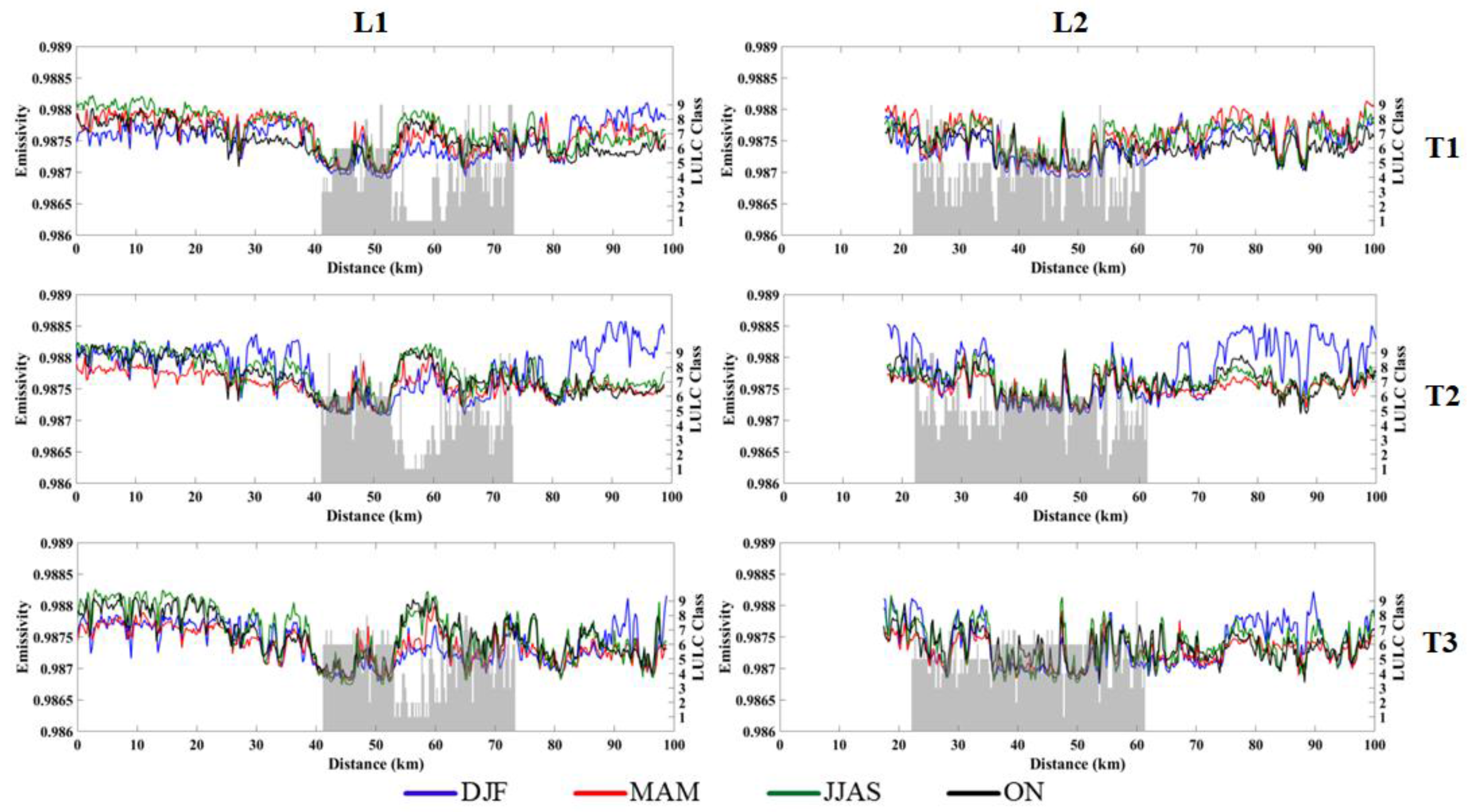
3.1. LULC Description along Transects
3.2. Land-Air Interactions over the Transects
3.3. Statistical Associations among Various Variables
4. Conclusions
Supplementary Materials
Acknowledgments
Author Contributions
Conflicts of Interest
References
- Bechtel, B.; Alexander, P.J.; Böhner, J.; Ching, J.; Conrad, O.; Feddema, J.; Mills, G.; See, L.; Stewart, I. Mapping local climate zones for a worldwide database of the form and function of cities. ISPRS Int. Geo-Inf. 2015, 4, 199–219. [Google Scholar] [CrossRef]
- United Nations. World Population Prospects 2017. Available online: http://esa.un.org/wpp/Documentation/publications.htm (accessed on 7 April 2015).
- Weng, Q.; Yang, S. Managing the adverse thermal effects of urban development in a densely populated Chinese city. J. Environ. Manag. 2004, 70, 145–156. [Google Scholar] [CrossRef] [PubMed]
- Stewart, I.D.; Oke, T.R. Local climate zones for urban temperature studies. Bull. Amer. Meteor. Soc. 2012, 93, 1879–1900. [Google Scholar] [CrossRef]
- Rosenzweig, C.; Solecki, W.; Hammer, S.A.; Mehrotra, S. Cities lead the way in climate-change action. Nature 2010, 467, 909–911. [Google Scholar] [CrossRef] [PubMed]
- Stone, B.; Hess, J.J.; Frumkin, H. Urban form and extreme heat events: Are sprawling cities more vulnerable to climate change than compact cities. Environ. Health Persp. 2010, 118, 1425–1428. [Google Scholar] [CrossRef] [PubMed]
- Ge, Y.; Dou, W.; Liu, N. Planning resilient and sustainable cities: Identifying and targeting social vulnerability to climate change. Sustainability 2017, 9, 1394. [Google Scholar] [CrossRef]
- Oke, T.R. The energetic basis of the urban heat island. Q. J. R. Meteorol. Soc. 1982, 108, 1–24. [Google Scholar] [CrossRef]
- Arnfield, A.J. Two decades of urban climate research: A review of turbulence, exchanges of energy and water, and the urban heat island. Int. J. Climatol. 2003, 23, 1–26. [Google Scholar] [CrossRef]
- Martilli, A. Numerical study of urban impact on boundary layer structure: Sensitivity to wind speed, urban morphology, and rural soil moisture. J. Appl. Meteorol. 2002, 41, 1247–1266. [Google Scholar] [CrossRef]
- Karl, T.R.; Trenberth, K.E. Modern global climate change. Science 2003, 302, 1719–1723. [Google Scholar] [CrossRef] [PubMed]
- Mitra, C.; Shepherd, J.M.; Jordan, T. On the relationship between the premonsoonal rainfall climatology and urban land cover dynamics in Kolkata city, India. Int. J. Climatol. 2012, 32, 1443–1454. [Google Scholar] [CrossRef]
- Shepherd, J.M. A review of current investigations of urban-induced rainfall and recommendations for the future. Earth Interact. 2005, 9, 1–27. [Google Scholar] [CrossRef]
- Dickinson, R.E. Land-atmosphere interaction. Rev. Geophys. 1995, 33, 917–922. [Google Scholar] [CrossRef]
- Guide to meteorological instruments and methods of observation (WMO-No. 8). Available online: Https://library.wmo.int/pmb_ged/wmo_8_en-2012.pdf (accessed on 30 May 2017).
- Pielke, R.A.; Pitman, A.; Niyogi, D.; Mahmood, R.; McAlpine, C.; Hossain, F.; Goldewijk, K.K.; Nair, U.; Betts, R.; Fall, S.; et al. Land use/land cover changes and climate: Modeling analysis and observational evidence. Wiley Interdiscip. Rev.: Clim. Chang. 2011, 2, 828–850. [Google Scholar] [CrossRef]
- Foley, J.A.; DeFries, R.; Asner, G.P.; Barford, C.; Bonan, G.; Carpenter, S.R.; Chapin, F.S.; Coe, M.T.; Daily, G.C.; Gibbs, H.K.; et al. Global consequences of land use. Science 2005, 309, 570–574. [Google Scholar] [CrossRef] [PubMed]
- Grimmond, C.S.B.; Oke, T.R. Aerodynamic properties of urban areas derived from analysis of surface form. J. Appl. Meteorol. 1999, 38, 1262–1292. [Google Scholar] [CrossRef]
- Xian, G.; Crane, M. An analysis of urban thermal characteristics and associated land cover in Tampa Bay and Las Vegas using Landsat satellite data. Remote Sens. Environ. 2006, 104, 147–156. [Google Scholar] [CrossRef]
- Chen, X.L.; Zhao, H.M.; Li, P.X.; Yin, Z.Y. Remote sensing image-based analysis of the relationship between urban heat island and land use/cover changes. Remote Sens. Environ. 2006, 104, 133–146. [Google Scholar] [CrossRef]
- Stathopoulou, M.; Cartalis, C. Downscaling AVHRR land surface temperatures for improved surface urban heat island intensity estimation. Remote Sens. Environ. 2009, 113, 2592–2605. [Google Scholar] [CrossRef]
- Bowler, D.E.; Buyung-Ali, L.; Knight, T.M.; Pullin, A.S. Urban greening to cool towns and cities: A systematic review of the empirical evidence. Landsc. Urban Plan. 2010, 97, 147–155. [Google Scholar] [CrossRef]
- Hua, W.; Chen, H.; Zhou, L.; Xie, Z.; Qin, M.; Li, X.; Ma, H.; Huang, Q.; Sun, S. Observational quantification of climatic and human influences on vegetation greening in China. Remote Sens. 2017, 9, 425. [Google Scholar] [CrossRef]
- Bowen, I.S. The ratio of heat losses by conduction and by evaporation from any water surface. Phys. Rev. 1926, 27, 779–787. [Google Scholar] [CrossRef]
- Betts, A.K.; Ball, J.H.; Beljaars, A.; Miller, M.J.; Viterbo, P.A. The land surface-atmosphere interaction: A review based on observational and global modeling perspectives. J. Geophys. Res. Atmos. 1996, 101, 7209–7225. [Google Scholar] [CrossRef]
- Nicholson, S. Land surface processes and Sahel climate. Rev. Geophys. 2000, 38, 117–139. [Google Scholar] [CrossRef]
- Wu, H.; Ye, L.P.; Shi, W.Z.; Clarke, K.C. Assessing the effects of land use spatial structure on urban heat islands using HJ-1B remote sensing imagery in Wuhan, China. Int. J. Appl. Earth Obs. 2014, 32, 67–78. [Google Scholar] [CrossRef]
- Shashua-Bar, L.; Hoffman, M.E. Vegetation as a climatic component in the design of an urban street: An empirical model for predicting the cooling effect of urban green areas with trees. Energ. Build. 2000, 31, 221–235. [Google Scholar] [CrossRef]
- Imhoff, M.L.; Zhang, P.; Wolfe, R.E.; Bounoua, L. Remote sensing of the urban heat island effect across biomes in the continental USA. Remote Sens. Environ. 2010, 114, 504–517. [Google Scholar] [CrossRef]
- Li, X.; Li, W.; Middel, A.; Harlan, S.L.; Brazel, A.J.; Turner, B.L. Remote sensing of the surface urban heat island and land architecture in Phoenix, Arizona: Combined effects of land composition and configuration and cadastral-demographic-economic factors. Remote Sens. Environ. 2016, 174, 233–243. [Google Scholar] [CrossRef]
- Zhou, L.; Dickinson, R.E.; Tian, Y.; Fang, J.; Li, Q.; Kaufmann, R.K.; Tucker, C.J.; Myneni, R.B. Evidence for a significant urbanization effect on climate in China. Proc. Natl. Acad. Sci. USA 2004, 101, 9540–9544. [Google Scholar] [CrossRef] [PubMed]
- Seneviratne, S.I.; Lüthi, D.; Litschi, M.; Schär, C. Land-atmosphere coupling and climate change in Europe. Nature 2006, 443, 205–209. [Google Scholar] [CrossRef] [PubMed]
- Kishtawal, C.M.; Niyogi, D.; Tewari, M.; Pielke, R.A.; Shepherd, J.M. Urbanization signature in the observed heavy rainfall climatology over India. Int. J. Climatol. 2010, 30, 1908–1916. [Google Scholar] [CrossRef]
- Shastri, H.; Paul, S.; Ghosh, S.; Karmakar, S. Impacts of urbanization on Indian summer monsoon rainfall extremes. J. Geophys. Res. Atmos. 2015, 120, 496–516. [Google Scholar] [CrossRef]
- McLeod, J.; Shepherd, M.; Konrad, C.E. Spatio-temporal rainfall patterns around Atlanta, Georgia and possible relationships to urban land cover. Urban Clim. 2017, 21, 27–42. [Google Scholar] [CrossRef]
- Niyogi, D.; Pyle, P.; Lei, M.; Arya, S.P.; Kishtawal, C.M.; Shepherd, M.; Chen, F.; Wolfe, B. Urban modification of thunderstorms: An observational storm climatology and model case study for the Indianapolis urban region. J. Appl. Meteorol. Clim. 2011, 50, 1129–1144. [Google Scholar] [CrossRef]
- Steiger, S.M.; Orville, R.E.; Huffines, G. Cloud-to-ground lightning characteristics over Houston, Texas: 1989–2000. J. Geophys. Res. Atmos. 2002, 107, 1–12. [Google Scholar] [CrossRef]
- Stallins, J.A.; Bentley, M.L. Urban lightning climatology and GIS: An analytical framework from the case study of Atlanta, Georgia. Appl. Geogr. 2006, 26, 242–259. [Google Scholar] [CrossRef]
- Jain, M.; Dawa, D.; Mehta, R.; Dimri, A.P.; Pandit, M.K. Monitoring land use change and its drivers in Delhi, India using multi-temporal satellite data. Model. Earth Syst. Environ. 2016, 2, 1–19. [Google Scholar]
- Dee, D.P.; Uppala, S.M.; Simmons, A.J.; Berrisford, P.; Poli, P.; Kobayashi, S.; Andrae, U.; Balmaseda, M.A.; Balsamo, G.; Bauer, P.; et al. The ERA-Interim reanalysis: Configuration and performance of the data assimilation system. Q. J. R. Meteorol. Soc. 2011, 137, 553–597. [Google Scholar] [CrossRef]
- Gao, L.; Schulz, K.; Bernhardt, M. Statistical downscaling of ERA-interim forecast precipitation data in complex terrain using lasso algorithm. Adv. Meteorol. 2014, 1–16. [Google Scholar] [CrossRef]
- Zhou, C.; Wang, K. Evaluation of surface fluxes in ERA-Interim using flux tower data. J. Clim. 2016, 29, 1573–1582. [Google Scholar] [CrossRef]
- Shastri, H.; Barik, B.; Ghosh, S.; Venkataraman, C.; Sadavarte, P. Flip flop of day-night and summer-winter surface urban heat island intensity in India. Sci. Rep. 2017, 7, 1–8. [Google Scholar] [CrossRef] [PubMed]
- Jain, M.; Dimri, A.P. Efficacy of filtering techniques in improving landsat SLC-off thermal infra-red data. IEEE J. Sel. Topics Appl. Earth Observ. Remote Sens. 2017, 99, 1–14. [Google Scholar] [CrossRef]
- NASA, Landsat 7 Science Data Users Handbook. Available online: https://landsat.gsfc.nasa.gov/wp-content/uploads/2016/08/Landsat7_Handbook.pdf (accessed on 8 September 2016).
- Sobrino, J.A.; Jiménez-Muñoz, J.C.; Paolini, L. Land surface temperature retrieval from LANDSAT TM 5. Remote Sens. Environ. 2004, 90, 434–440. [Google Scholar] [CrossRef]
- Tran, H.; Uchihama, D.; Ochi, S.; Yasuoka, Y. Assessment with satellite data of the urban heat island effects in Asian mega cities. Int. J. Appl. Earth Obs. 2006, 8, 34–48. [Google Scholar] [CrossRef]
- Jain, M.; Dimri, A.P.; Niyogi, D. Year-round daytime cold island in a highly urban city. Remote Sens. Environ. 2017. submitted. [Google Scholar]
- Vancutsem, C.; Ceccato, P.; Dinku, T.; Connor, S.J. Evaluation of MODIS land surface temperature data to estimate air temperature in different ecosystems over Africa. Remote Sens. Environ. 2010, 114, 449–465. [Google Scholar] [CrossRef]
- Carlson, T.N.; Ripley, D.A. On the relation between NDVI, fractional vegetation cover, and leaf area index. Remote Sens. Environ. 1997, 62, 241–252. [Google Scholar] [CrossRef]
- Houghton, R.A. The worldwide extent of land-use change. BioScience 1994, 44, 305–313. [Google Scholar] [CrossRef]
- Lunetta, R.S.; Knight, J.F.; Ediriwickrema, J.; Lyon, J.G.; Worthy, L.D. Land-cover change detection using multi-temporal MODIS NDVI data. Remote Sens. Environ. 2006, 105, 142–154. [Google Scholar] [CrossRef]
- Theeuwes, N.E.; Steeneveld, G.J.; Ronda, R.J.; Rotach, M.W.; Holtslag, A.A. Cool city mornings by urban heat. Environ. Res. Lett. 2015, 10, 1–9. [Google Scholar] [CrossRef]


| Variable | L1 | L2 | ||
|---|---|---|---|---|
| Mean | Std. Deviation | Mean | Std. Deviation | |
| LST (K) | 298.99 | 6.00 | 298.98 | 5.69 |
| NDVI | 0.27 | 0.110 | 0.24 | 0.100 |
| Emissivity | 0.988 | 0.00034 | 0.988 | 0.00031 |
| Skin Temperature (K) | 299.46 | 6.77 | 299.33 | 6.79 |
| Albedo | 0.18 | 0.007 | 0.1800 | 0.005 |
| Evaporation (mm/day) | 6.04 | 1.965 | 6.1 | 1.960 |
| Bowen Ratio | 0.37 | 0.12 | 0.34 | 0.11 |
| PBL Height (m) | 1002.96 | 857.24 | 996.24 | 846.92 |
| Correlation | Variable | LST | NDVI | Emissivity |
|---|---|---|---|---|
| Pearson’s correlation coefficient (r) | LST | 1.000 | ||
| NDVI | −0.127 ** | 1.000 | ||
| Emissivity | −0.137 ** | 0.880 ** | 1.000 | |
| Spearman rank correlation (ρ) | LST | 1.000 | ||
| NDVI | −0.182 ** | 1.000 | ||
| Emissivity | −0.177 ** | 0.881 ** | 1.000 | |
| Kendall rank correlation (τ) | LST | 1.000 | ||
| NDVI | −0.125 ** | 1.000 | ||
| Emissivity | −0.118 ** | 0.702 ** | 1.000 |
| Correlation | Variable | Skin Temperature | Albedo | Evaporation | Bowen Ratio | PBL Height |
|---|---|---|---|---|---|---|
| Pearson’s correlation coefficient (r) | Skin Temperature | 1.000 | ||||
| Albedo | −0.005 | 1.000 | ||||
| Evaporation | 0.872 ** | −0.196 * | 1.000 | |||
| Bowen Ratio | 0.117 | 0.274 ** | −0.373 ** | 1.000 | ||
| PBL Height | 0.815 ** | −0.022 | 0.467 ** | 0.616 ** | 1.000 | |
| Spearman rank correlation (ρ) | Skin Temperature | 1.000 | ||||
| Albedo | 0.233 * | 1.000 | ||||
| Evaporation | 0.724 ** | −0.183 | 1.000 | |||
| Bowen Ratio | 0.210 * | 0.282 ** | −0.448 ** | 1.000 | ||
| PBL Height | 0.786 ** | −0.116 | 0.523 ** | 0.393 ** | 1.000 | |
| Kendall rank correlation (τ) | Skin Temperature | 1.000 | ||||
| Albedo | 0.192 ** | 1.000 | ||||
| Evaporation | 0.417 ** | −0.175 ** | 1.000 | |||
| Bowen Ratio | 0.094 | 0.234 ** | −0.426 ** | 1.000 | ||
| PBL Height | 0.616 ** | −0.031 | 0.124 | 0.352 ** | 1.000 |
| Correlation | Variable | LST | NDVI | Emissivity |
|---|---|---|---|---|
| Pearson’s correlation coefficient (r) | LST | 1.000 | ||
| NDVI | −0.093 ** | 1.000 | ||
| Emissivity | −0.136 ** | 0.869 ** | 1.000 | |
| Spearman rank correlation (ρ) | LST | 1.000 | ||
| NDVI | −0.091 ** | 1.000 | ||
| Emissivity | −0.102 ** | 0.856 ** | 1.000 | |
| Kendall rank correlation (τ) | LST | 1.000 | ||
| NDVI | −0.066 ** | 1.000 | ||
| Emissivity | −0.069 ** | 0.669 ** | 1.000 |
| Correlation | Variable | Skin Temperature | Albedo | Evaporation | Bowen Ratio | PBL Height |
|---|---|---|---|---|---|---|
| Pearson’s correlation coefficient (r) | Skin Temperature | 1.000 | ||||
| Albedo | −0.037 | 1.000 | ||||
| Evaporation | 0.880 ** | −0.166 | 1.000 | |||
| Bowen Ratio | 0.152 | 0.109 | −0.325 ** | 1.000 | 0.668 ** | |
| PBL Height | 0.815 ** | −0.099 | 0.472 ** | 0.668 ** | 1.000 | |
| Spearman rank correlation (ρ) | Skin Temperature | 1.000 | ||||
| Albedo | 0.127 | 1.000 | ||||
| Evaporation | 0.747 ** | −0.193 * | 1.000 | |||
| Bowen Ratio | 0.179 | 0.217 * | −0.412 ** | 1.000 | ||
| PBL Height | 0.775 ** | −0.306 ** | 0.539 ** | 0.413 ** | 1.000 | |
| Kendall rank correlation (τ) | Skin Temperature | 1.000 | ||||
| Albedo | 0.070 | 1.000 | ||||
| Evaporation | 0.491 ** | −0.221 ** | 1.000 | |||
| Bowen Ratio | 0.047 | 0.132* | −0.364 ** | 1.000 | ||
| PBL Height | 0.597 ** | −0.170 ** | 0.171 ** | 0.383 ** | 1.000 |
© 2017 by the authors. Licensee MDPI, Basel, Switzerland. This article is an open access article distributed under the terms and conditions of the Creative Commons Attribution (CC BY) license (http://creativecommons.org/licenses/by/4.0/).
Share and Cite
Jain, M.; Dimri, A.P.; Niyogi, D. Land-Air Interactions over Urban-Rural Transects Using Satellite Observations: Analysis over Delhi, India from 1991–2016. Remote Sens. 2017, 9, 1283. https://doi.org/10.3390/rs9121283
Jain M, Dimri AP, Niyogi D. Land-Air Interactions over Urban-Rural Transects Using Satellite Observations: Analysis over Delhi, India from 1991–2016. Remote Sensing. 2017; 9(12):1283. https://doi.org/10.3390/rs9121283
Chicago/Turabian StyleJain, Madhavi, A. P. Dimri, and Dev Niyogi. 2017. "Land-Air Interactions over Urban-Rural Transects Using Satellite Observations: Analysis over Delhi, India from 1991–2016" Remote Sensing 9, no. 12: 1283. https://doi.org/10.3390/rs9121283
APA StyleJain, M., Dimri, A. P., & Niyogi, D. (2017). Land-Air Interactions over Urban-Rural Transects Using Satellite Observations: Analysis over Delhi, India from 1991–2016. Remote Sensing, 9(12), 1283. https://doi.org/10.3390/rs9121283