Characterizing Drought and Flood Events over the Yangtze River Basin Using the HUST-Grace2016 Solution and Ancillary Data

 ,
,  ,
,
Abstract
1. Introduction
2. Study Region and Data Processing
2.1. Study Region
2.2. Data and Data Processing
2.2.1. GRACE Data
2.2.2. Hydrological Models
2.2.3. MODIS Data
2.2.4. TRMM Data
2.2.5. NCEP/NCAR Reanalysis Data
3. Results and Discussion
3.1. TWS Variations Over the YRB
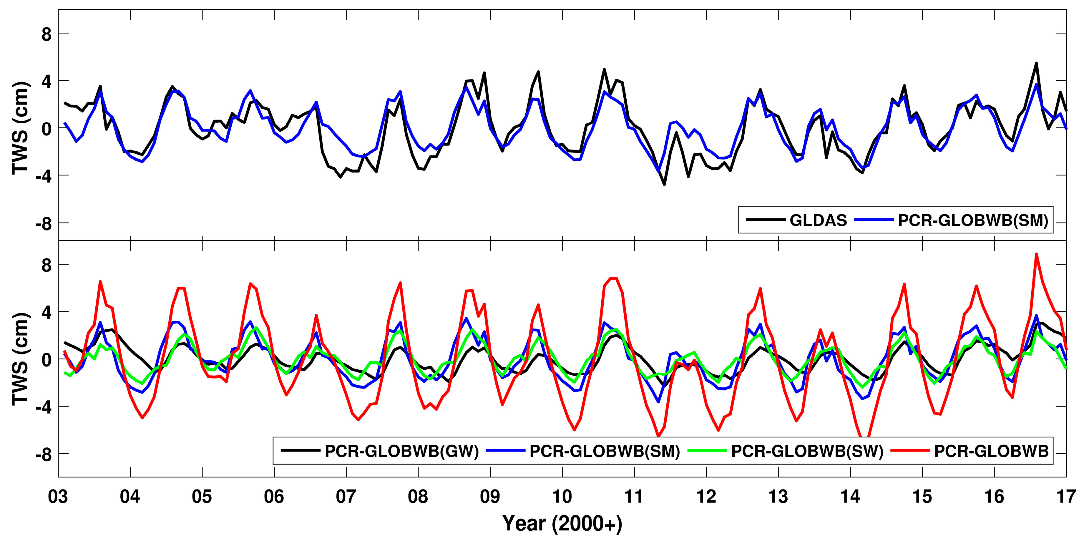
3.1.1. TWS Derived from Hydrological Models
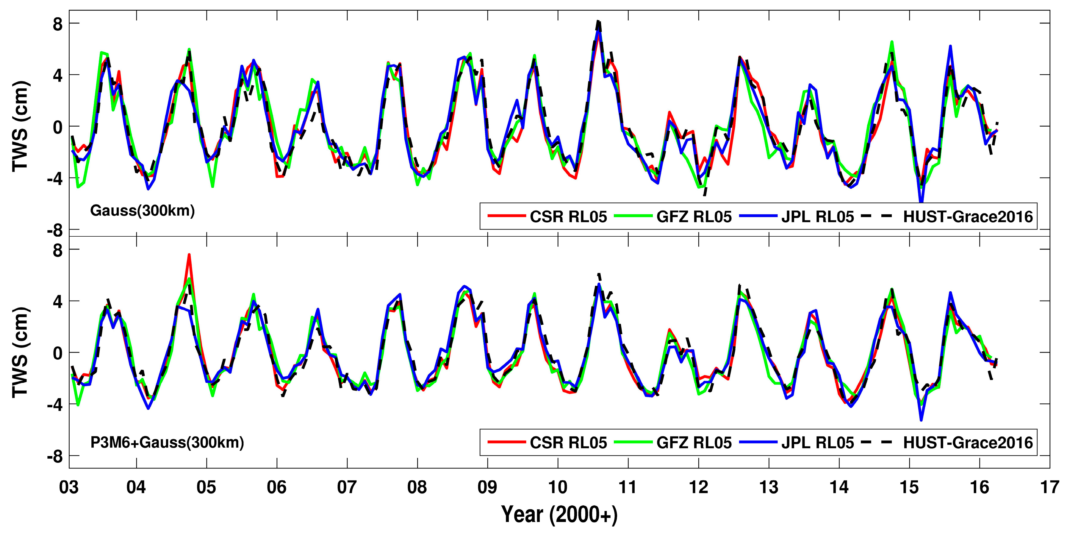
3.1.2. TWS Derived from the HUST-Grace2016 Model
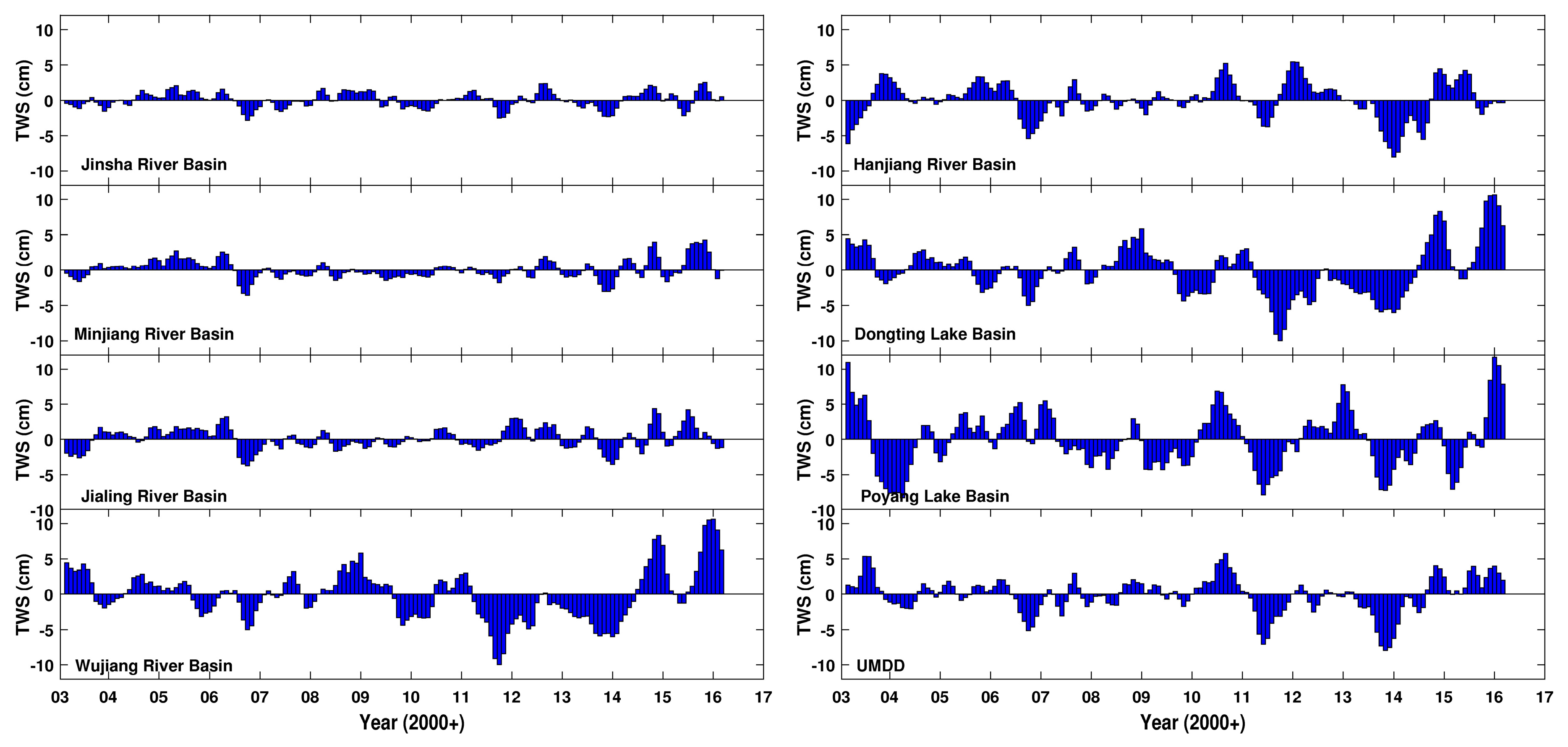
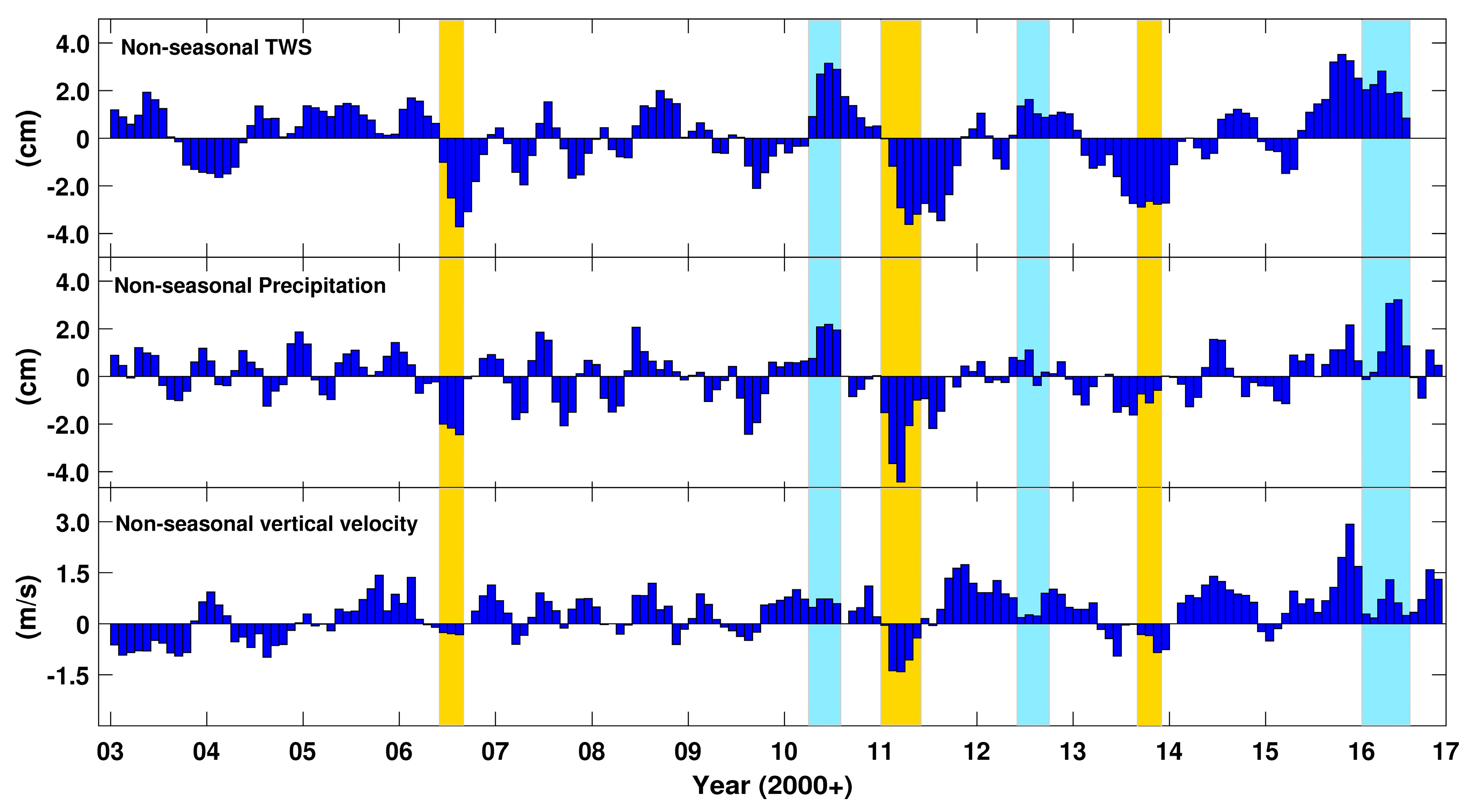
3.1.3. Non-seasonal TWS Variations Over Sub-Basins
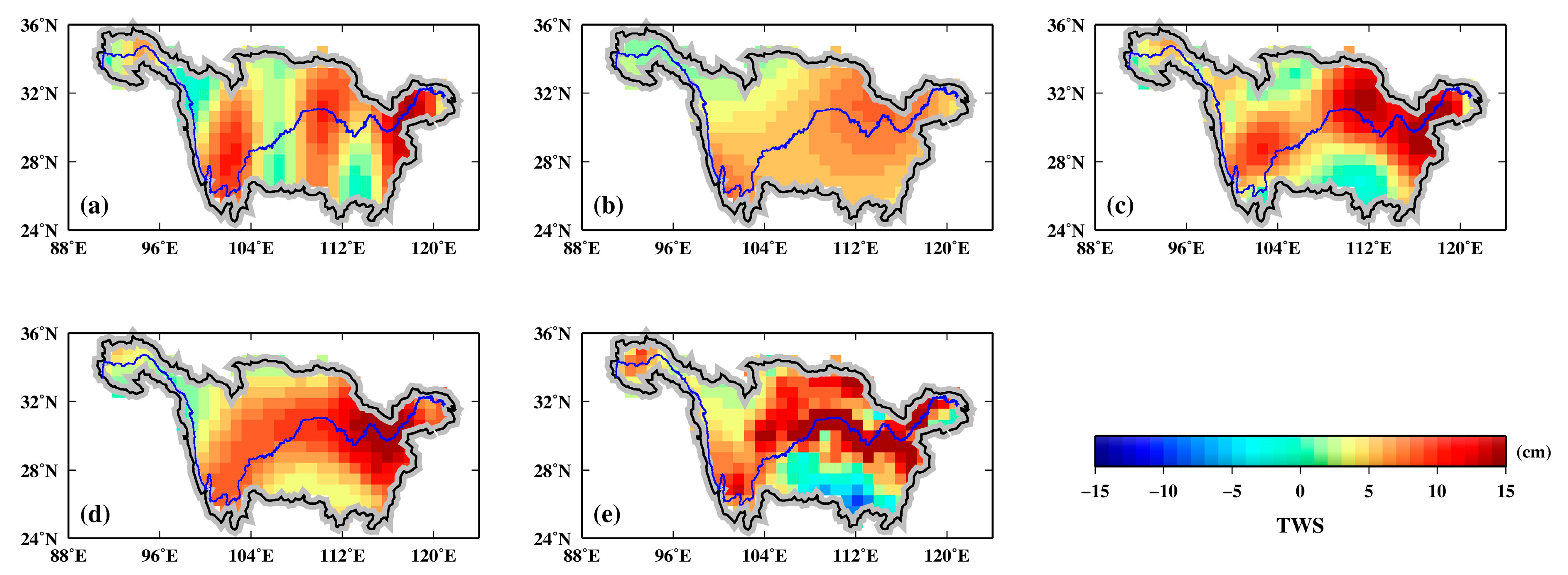
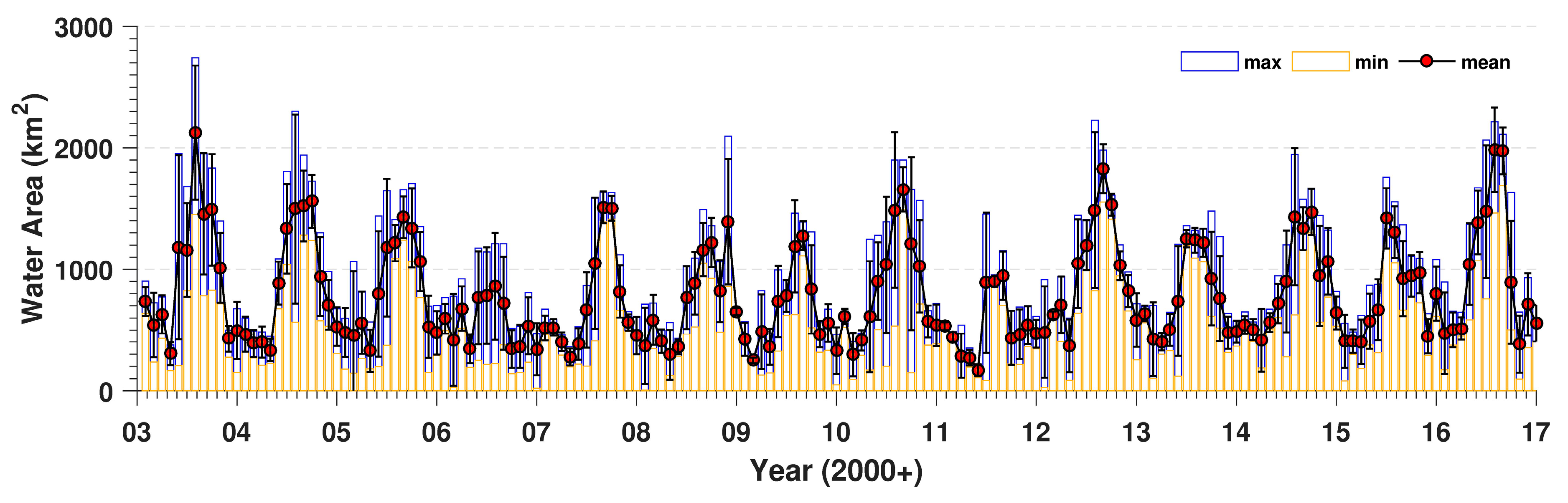
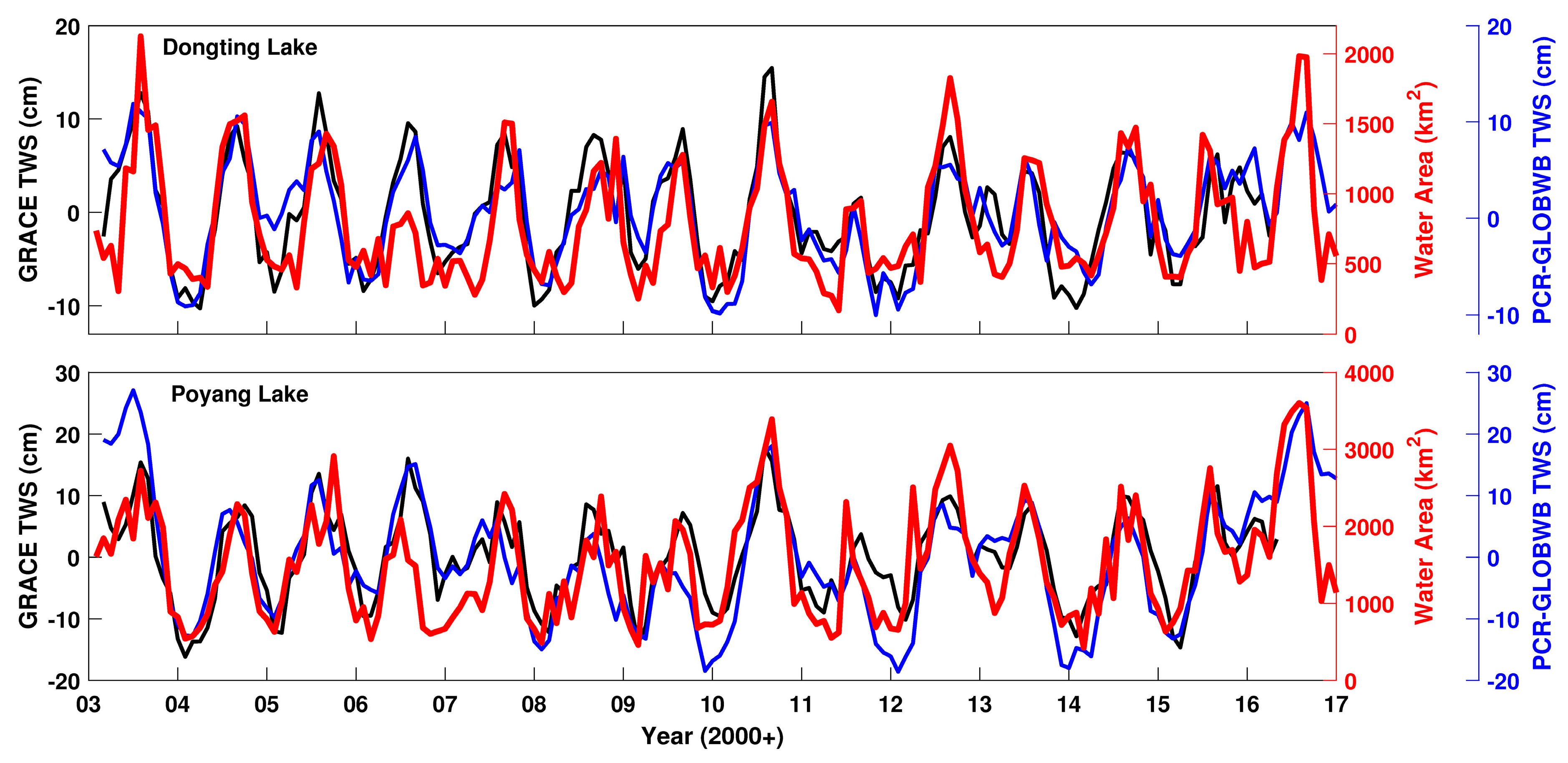
3.2. MODIS-Derived Inundated Area Variations
3.3. NCEP/NCAR Vertical Velocity
4. Summary and Conclusions
Acknowledgments
Author Contributions
Conflicts of Interest
References
- Dai, Z.; Du, J.; Li, J.; Li, W.; Chen, J. Runoff characteristics of the Changjiang River during 2006: Effect of extreme drought and the impounding of the Three Gorges Dam. Geophys. Res. Lett. 2008, 35. [Google Scholar] [CrossRef]
- Zhang, Z.Z.; Chao, B.F.; Chen, J.L.; Wilson, C.R. Terrestrial water storage anomalies of Yangtze River Basin droughts observed by GRACE and connections with ENSO. Global Planet. Chang. 2015, 126, 35–45. [Google Scholar] [CrossRef]
- Long, D.; Yang, Y.; Wada, Y.; Hong, Y.; Liang, W.; Chen, Y.; Yong, B.; Hu, A.; Wei, J.; Chen, L. Deriving scaling factors using a global hydrological model to restore GRACE total water storage changes for China’s Yangtze River Basin. Remote Sens. Environ. 2015, 168, 177–193. [Google Scholar] [CrossRef]
- Han, S.C.; Kim, H.; Yeo, I.Y.; Yeh, P.; Oki, T.; Seo, K.W.; Alsdorf, D.; Luthcke, S.B. Dynamics of surface water storage in the Amazon inferred from measurements of inter-satellite distance change. Geophys. Res. Lett. 2009, 36. [Google Scholar] [CrossRef]
- Xavier, L.; Becker, M.; Cazenave, A.; Longuevergne, L.; Llovel, W.; Rotunno Filho, O.C. Interannual variability in water storage over 2003–2008 in the Amazon basin from GRACE space gravimetry, in situ river level and precipitation data. Remote Sens. Environ. 2010, 114, 1629–1637. [Google Scholar] [CrossRef]
- Awange, J.; Forootan, E.; Kuhn, M.; Kusche, J.; Heck, B. Water storage changes and climate variability within the Nile Basin between 2002 and 2011. Adv. Water Resour. 2014, 73, 1–15. [Google Scholar] [CrossRef]
- Yao, C.; Luo, Z.; Wang, H.; Li, Q.; Zhou, H. GRACE-derived terrestrial water storage changes in the inter-basin region and its possible influencing factors: A case study of the Sichuan Basin, China. Remote Sens. 2016, 8, 444. [Google Scholar] [CrossRef]
- Long, D.; Shen, Y.; Sun, A.; Hong, Y.; Longuevergne, L.; Yang, Y.; Li, B.; Chen, L. Drought and flood monitoring for a large karst plateau in Southwest China using extended GRACE data. Remote Sens. Environ. 2015, 155, 145–160. [Google Scholar] [CrossRef]
- Bettadpur, S. Gravity Recovery and Climate Experiment UTCSR Level-2 processing standards document for Level-2 product release 0005. In Center for Space Research; University of Texas: Austin, TX, USA, 2012. [Google Scholar]
- Dahle, C.; Flechtner, F.; Gruber, C.; König, D.; König, R.; Michalak, G.; Neumayer, K.H. GFZ GRACE level-2 processing standards document for level-2 product release 0005. In Scientific Technical Report-Data; University of Texas: Austin, TX, USA, 2012. [Google Scholar]
- Watkins, M.M.; Yuan, D.N. GRACE JPL Level-2 Processing Standards Document for Level-2 Product Release 05. In GRACE 327–744 (v 5.0); Jet Propulsion Laboratory: Pasadena, CA, USA, 2012. [Google Scholar]
- Zhou, H.; Luo, Z.; Zhou, Z.; Li, Q.; Zhong, B.; Hsu, H. HUST-Grace2016: A new GRACE monthly gravity field model computed using a modified dynamic approach. J. Geophys. Res. 2017. [Google Scholar] [CrossRef]
- Sakumura, C.; Bettadpur, S.; Bruinsma, S. Ensemble prediction and intercomparison analysis of GRACE time-variable gravity field models. Geophys. Res. Lett. 2014, 41, 1389–1397. [Google Scholar] [CrossRef]
- Xiao, R.; He, X.; Zhang, Y.; Ferreira, V.G.; Chang, L. Monitoring Groundwater Variations from Satellite Gravimetry and Hydrological Models: A Comparison with in-situ Measurements in the Mid-Atlantic Region of the United States. Remote Sens. 2015, 7, 686–703. [Google Scholar] [CrossRef]
- Wada, Y.; Wisser, D.; Bierkens, M.F.P. Global modeling of withdrawal, allocation and consumptive use of surface water and groundwater resources. Earth Syst. Dyn. 2014, 5, 15–40. [Google Scholar] [CrossRef]
- Tangdamrongsub, N.; Ditmar, P.G.; Steele-Dunne, S.C.; Gunter, B.C.; Sutanudjaja, E.H. Assessing total water storage and identifying flood events over Tonlé Sap basin in Cambodia using GRACE and MODIS satellite observations combined with hydrological models. Remote Sens. Environ. 2016, 181, 162–173. [Google Scholar] [CrossRef]
- Tangdamrongsub, N.; Steele-Dunne, S.C.; Gunter, B.C.; Ditmar, P.G.; Sutanudjaja, E.H.; Sun, Y.; Xia, T.; Wang, Z.J. Improving estimates of water resources in a semi-arid region by assimilating GRACE data into the PCR-GLOBWB hydrological model. Hydrol. Earth Syst. Sci. 2017, 21, 2053–2074. [Google Scholar] [CrossRef]
- Rodell, M.; Houser, P.; Jambor, U.E.A.; Gottschalck, J.; Mitchell, K.; Meng, C.J.; Arsenault, K.; Cosgrove, B.; Radakovich, J.; Bosilovich, M. The global land data assimilation system. Bull. Am. Meteorol. Soc. 2004, 85, 381–394. [Google Scholar] [CrossRef]
- Feng, L.; Hu, C.; Chen, X.; Cai, X.; Tian, L.; Gan, W. Assessment of inundation changes of Poyang Lake using MODIS observations between 2000 and 2010. Remote Sens. Environ. 2012, 121, 80–92. [Google Scholar] [CrossRef]
- Forootan, E.; Awange, J.L.; Kusche, J.; Heck, B.; Eicker, A. Independent patterns of water mass anomalies over Australia from satellite data and models. Remote Sens. Environ. 2012, 124, 427–443. [Google Scholar] [CrossRef]
- Forootan, E.; Khandu; Awange, J.L.; Schumacher, M.; Anyah, R.O.; van Dijk, A.I.J.M.; Kusche, J. Quantifying the impacts of ENSO and IOD on rain gauge and remotely sensed precipitation products over Australia. Remote Sens. Environ. 2016, 172, 50–66. [Google Scholar] [CrossRef]
- Morishita, Y.; Heki, K. Characteristic precipitation patterns of El Niño/La Niña in time-variable gravity fields by GRACE. Earth Planet. Sci. Lett. 2008, 272, 677–682. [Google Scholar] [CrossRef]
- Wouters, B.; Bonin, J.A.; Chambers, D.P.; Riva, R.E.; Sasgen, I.; Wahr, J. GRACE, time-varying gravity, Earth system dynamics and climate change. Rep. Prog. Phys. 2014, 77. [Google Scholar] [CrossRef] [PubMed]
- García-García, D.; Ummenhofer, C.C.; Zlotnicki, V. Australian water mass variations from GRACE data linked to Indo-Pacific climate variability. Remote Sens. Environ. 2011, 115, 2175–2183. [Google Scholar] [CrossRef]
- Linage, C.D.; Kim, H.; Famiglietti, J.S.; Yu, J.Y. Impact of Pacific and Atlantic sea surface temperatures on interannual and decadal variations of GRACE land water storage in tropical South America. J. Geophys. Res. 2013, 118, 10811–10829. [Google Scholar] [CrossRef]
- Kalnay, E.; Kanamitsu, M.; Kistler, R.; Collins, W.; Deaven, D.; Gandin, L.; Iredell, M.; Saha, S.; White, G.; Woollen, J.; et al. The NCEP/NCAR 40-year reanalysis project. Bull. Am. Meteorol. Soc. 1996, 77, 437–470. [Google Scholar] [CrossRef]
- Swenson, S.C.; Chambers, D.; Wahr, J. Estimating geocenter variations from a combination of GRACE and ocean model output. J. Geophys. Res. 2008, 113. [Google Scholar] [CrossRef]
- Cheng, M.; Tapley, B. Variations in the Earth’s oblateness during the past 28 years. J. Geophys. Res. 2004, 109. [Google Scholar] [CrossRef]
- Jekeli, C. Alternative methods to smooth the earth’s gravity field. In Scientific Report, 327; The Ohio State University: Columbus, OH, USA, 1981. [Google Scholar]
- Swenson, S.C.; Wahr, J. Post-processing removal of correlated errors in GRACE data. Geophys. Res. Lett. 2006, 33. [Google Scholar] [CrossRef]
- Chen, J.L.; Wilson, C.R.; Li, J.; Zhang, Z. Reducing leakage error in grace-observed long-term ice mass change: A case study in west Antarctica. J. Geod. 2015, 89, 925–940. [Google Scholar] [CrossRef]
- Chen, J.L.; Famiglietti, J.S.; Scanlon, B.; Rodell, M. Groundwater storage changes: Present status from GRACE observations. Surv. Geophys. 2016, 37, 397–417. [Google Scholar] [CrossRef]
- Chen, J.L.; Li, J.; Zhang, Z.; Ni, S. Long-term groundwater variations in Northwest India from satellite gravity measurements. Global Planet. Chang. 2014, 116, 130–138. [Google Scholar] [CrossRef]
- Chen, J.L.; Wilson, C.R.; Tapley, B.D. Contribution of ice sheet and mountain glacier melt to recent sea level rise. Nat. Geosci. 2013, 6, 549–552. [Google Scholar] [CrossRef]
- Save, H.; Bettadpur, S.; Tapley, B.D. High-resolution CSR GRACE RL05 mascons. J. Geophys. Res. 2016, 121, 7547–7569. [Google Scholar] [CrossRef]
- Landerer, F.W.; Swenson, S.C. Accuracy of scaled GRACE terrestrial water storage estimates. Water Resour. Res. 2012, 48. [Google Scholar] [CrossRef]
- Long, D.; Pan, Y.; Zhou, J.; Chen, Y.; Hou, X.Y.; Hong, Y.; Scanlon, B.R.; Longuevergne, L. Global analysis of spatiotemporal variability in merged total water storage changes using multiple GRACE products and global hydrological models. Remote Sens. Environ. 2017, 192, 198–216. [Google Scholar] [CrossRef]
- Vermote, E.F.; Kotchenova, S.Y.; Ray, J.P. MODIS Surface Reflectance User’s Guide Version 1.3. 2011. Available online: Http://modis-sr.ltdri.org/guide/MOD09_UserGuide_v1_3.pdf (accessed on 30 June 2017).
- McFeeters, S.K. The use of the normalized difference water index (NDWI) in the delineation of open water features. Int. J. Remote Sens. 1996, 17, 1425–1432. [Google Scholar] [CrossRef]
- Huffman, G.J.; Bolvin, D.T. TRMM and Other Data Precipitation Data Set Documentation. 2017. Available online: Https://pmm.nasa.gov/sites/default/files/document_files/3B42_3B43_doc_V7_4_19_17.pdf (accessed on 30 June 2017).
- Moriasi, D.N.; Arnold, J.G.; Van Liew, M.W.; Bingner, R.L.; Harmel, R.D.; Veith, T.L. Model evaluation guidelines for systematic quantification of accuracy in watershed simulations. Trans. ASABE 2007, 50, 885–900. [Google Scholar] [CrossRef]
- Wang, J.; Sheng, Y.; Wada, Y. Little impact of the Three Gorges Dam on recent decadal lake decline across China’s Yangtze Plain. Water Resour. Res. 2017, 53, 3854–3877. [Google Scholar] [CrossRef]
- Klokočník, J.; Gooding, R.H.; Wagner, C.A.; Kostelecký, J.; Bezděk, A. The Use of Resonant Orbits in Satellite Geodesy: A Review. Surv. Geophys. 2013, 34, 43–72. [Google Scholar] [CrossRef]
- Klokočník, J.; Wagner, C.A.; Kostelecký, J.; Bezděk, A.; Novak, P.; McAdoo, D. Variations in the accuracy of gravity recovery due to ground track variability: GRACE, CHAMP, and GOCE. J. Geod. 2008, 82, 917–927. [Google Scholar] [CrossRef]
- Jiang, Q.; Ferreira, V.G.; Chen, J. Monitoring groundwater changes in the Yangtze River basin using satellite and model data. Arab J. Geosci. 2016, 9, 500–506. [Google Scholar] [CrossRef]
- Back, L.E.; Bretherton, C.S. A simple model of climatological rainfall and vertical motion patterns over the tropical oceans. J. Clim. 2009, 22, 6477–6497. [Google Scholar] [CrossRef]
- Stepanyuk, O.; Räisänen, J.; Sinclair, V.A.; Järvinen, H. Factors affecting atmospheric vertical motions as analyzed with a generalized omega equation and the OpenIFS model. Tellus A 2017, 69. [Google Scholar] [CrossRef]
- Andam-Akorful, S.A.; Ferreira, V.G.; Awange, J.L.; Forootan, E.; He, X.F. Multi-model and multi-sensor estimations of evapotranspiration over the Volta Basin, West Africa. Int. J. Climatol. 2015, 35, 3132–3145. [Google Scholar] [CrossRef]
- Sun, T.; Ferreira, V.; He, X.; Andam-Akorful, S. Water Availability of São Francisco River Basin Based on a Space-Borne Geodetic Sensor. Water 2016, 8, 213. [Google Scholar] [CrossRef]


| Location | Sub-Basin | Contribution Percentage (%) | Correlation Coefficient | ||||
|---|---|---|---|---|---|---|---|
| GW | SM | SW | GW | SM | SW | ||
| WYRB | Jinsha River | 20.4 | 72.3 | 7.3 | 0.64 | 0.98 | 0.91 |
| Minjiang River | 24.1 | 65.8 | 10.1 | 0.84 | 0.97 | 0.95 | |
| Jialing River | 26.9 | 59.6 | 13.4 | 0.95 | 0.98 | 0.93 | |
| Wujiang River | 22.6 | 63.9 | 13.5 | 0.86 | 0.96 | 0.80 | |
| EYRB | Hanjiang River | 17.9 | 50.6 | 31.5 | 0.88 | 0.97 | 0.96 |
| Dongting Lake | 15.9 | 58.3 | 25.8 | 0.80 | 0.87 | 0.93 | |
| Poyang Lake | 19.6 | 58.5 | 21.9 | 0.82 | 0.85 | 0.91 | |
| UMDD | 20.2 | 22.8 | 57.0 | 0.76 | 0.73 | 0.92 | |
| Models | Gauss (300 km) | P3M6 + Gauss (300 km) | ||
|---|---|---|---|---|
| Annual Amplitude | Annual Phase | Annual Amplitude | Annual Phase | |
| HUST-Grace2016 | 3.19 ± 0.35 | 4.00 ± 0.14 | 2.96 ± 0.33 | 4.40 ± 0.15 |
| CSR RL05 | 3.19 ± 0.36 | 4.02 ± 0.14 | 2.96 ± 0.33 | 4.41 ± 0.15 |
| JPL RL05 | 3.23 ± 0.36 | 3.95 ± 0.13 | 2.93 ± 0.33 | 4.37 ± 0.15 |
| GFZ RL05 | 3.22 ± 0.36 | 3.97 ± 0.13 | 3.00 ± 0.34 | 4.33 ± 0.14 |
| Ensemble model | 3.21 ± 0.34 | 3.99 ± 0.13 | 2.96 ± 0.30 | 4.39 ± 0.13 |
| Solutions | Annual Amplitude | Annual Phase | Correlation w.r.t. PCR-GLOBWB | RMS Difference w.r.t. PCR-GLOBWB |
|---|---|---|---|---|
| HUST Before FM | 2.96 ± 0.33 | 4.40 ± 0.15 | 0.90 | 1.87 |
| HUST After FM | 4.28 ± 0.48 | 4.73 ± 0.14 | 0.92 | 1.59 |
| CSR Mascon | 4.24 ± 0.48 | 4.71 ± 0.10 | 0.90 | 1.62 |
| CSR Tellus grids (no scale factor) | 3.62 ± 0.40 | 4.98 ± 0.12 | 0.89 | 1.71 |
| CSR Tellus grids (with scale factor) | 5.98 ± 0.66 | 4.34 ± 0.07 | 0.92 | 2.41 |
| PCR-GLOBWB | 4.35 ± 0.48 | 4.89 ± 0.10 | - | - |
| Location | Sub-Basins | Correlations Coefficients (TWS Variations) | Correlations Coefficients (Non-Seasonal TWS Variations) |
|---|---|---|---|
| WYRB | Jinsha River | 0.83 | 0.70 |
| Minjiang River | 0.88 | 0.63 | |
| Jialing River | 0.83 | 0.70 | |
| Wujiang River | 0.72 | 0.80 | |
| EYRB | Hanjiang River | 0.84 | 0.82 |
| Dongting Lake | 0.91 | 0.84 | |
| Poyang Lake | 0.84 | 0.81 | |
| UMDD | 0.83 | 0.79 |
| Month | Jan | Feb | Mar | Apr | May | Jun | Jul | Aug | Sep | Oct | Nov | Dec | |
|---|---|---|---|---|---|---|---|---|---|---|---|---|---|
| Max | Year | 2003 | 2012 | 2012 | 2016 | 2016 | 2016 | 2003 | 2016 | 2004 | 2005 | 2008 | 2015 |
| Area | 735.3 | 624.0 | 708.8 | 1043.3 | 1385.2 | 1474.8 | 2124.4 | 1975.0 | 1559.3 | 1064.2 | 1392.5 | 799.0 | |
| Min | Year | 2008 | 2009 | 2011 | 2011 | 2011 | 2007 | 2006 | 2006 | 2006 | 2006 | 2003 | 2009 |
| Area | 370.0 | 249.6 | 288.3 | 272.2 | 169.4 | 664.3 | 860.4 | 720.0 | 344.3 | 365.3 | 429.0 | 331.3 | |
| Max/Min Ratio | 1.99 | 2.50 | 2.46 | 3.83 | 8.18 | 2.22 | 2.47 | 2.74 | 4.53 | 2.91 | 3.25 | 2.41 | |
© 2017 by the authors. Licensee MDPI, Basel, Switzerland. This article is an open access article distributed under the terms and conditions of the Creative Commons Attribution (CC BY) license (http://creativecommons.org/licenses/by/4.0/).
Share and Cite
Zhou, H.; Luo, Z.; Tangdamrongsub, N.; Wang, L.; He, L.; Xu, C.; Li, Q. Characterizing Drought and Flood Events over the Yangtze River Basin Using the HUST-Grace2016 Solution and Ancillary Data. Remote Sens. 2017, 9, 1100. https://doi.org/10.3390/rs9111100
Zhou H, Luo Z, Tangdamrongsub N, Wang L, He L, Xu C, Li Q. Characterizing Drought and Flood Events over the Yangtze River Basin Using the HUST-Grace2016 Solution and Ancillary Data. Remote Sensing. 2017; 9(11):1100. https://doi.org/10.3390/rs9111100
Chicago/Turabian StyleZhou, Hao, Zhicai Luo, Natthachet Tangdamrongsub, Lunche Wang, Lijie He, Chuang Xu, and Qiong Li. 2017. "Characterizing Drought and Flood Events over the Yangtze River Basin Using the HUST-Grace2016 Solution and Ancillary Data" Remote Sensing 9, no. 11: 1100. https://doi.org/10.3390/rs9111100
APA StyleZhou, H., Luo, Z., Tangdamrongsub, N., Wang, L., He, L., Xu, C., & Li, Q. (2017). Characterizing Drought and Flood Events over the Yangtze River Basin Using the HUST-Grace2016 Solution and Ancillary Data. Remote Sensing, 9(11), 1100. https://doi.org/10.3390/rs9111100