Satellite Monitoring of Urban Land Change in the Middle Yangtze River Basin Urban Agglomeration, China between 2000 and 2016


Abstract
:
1. Introduction
2. Study Area and Datasets
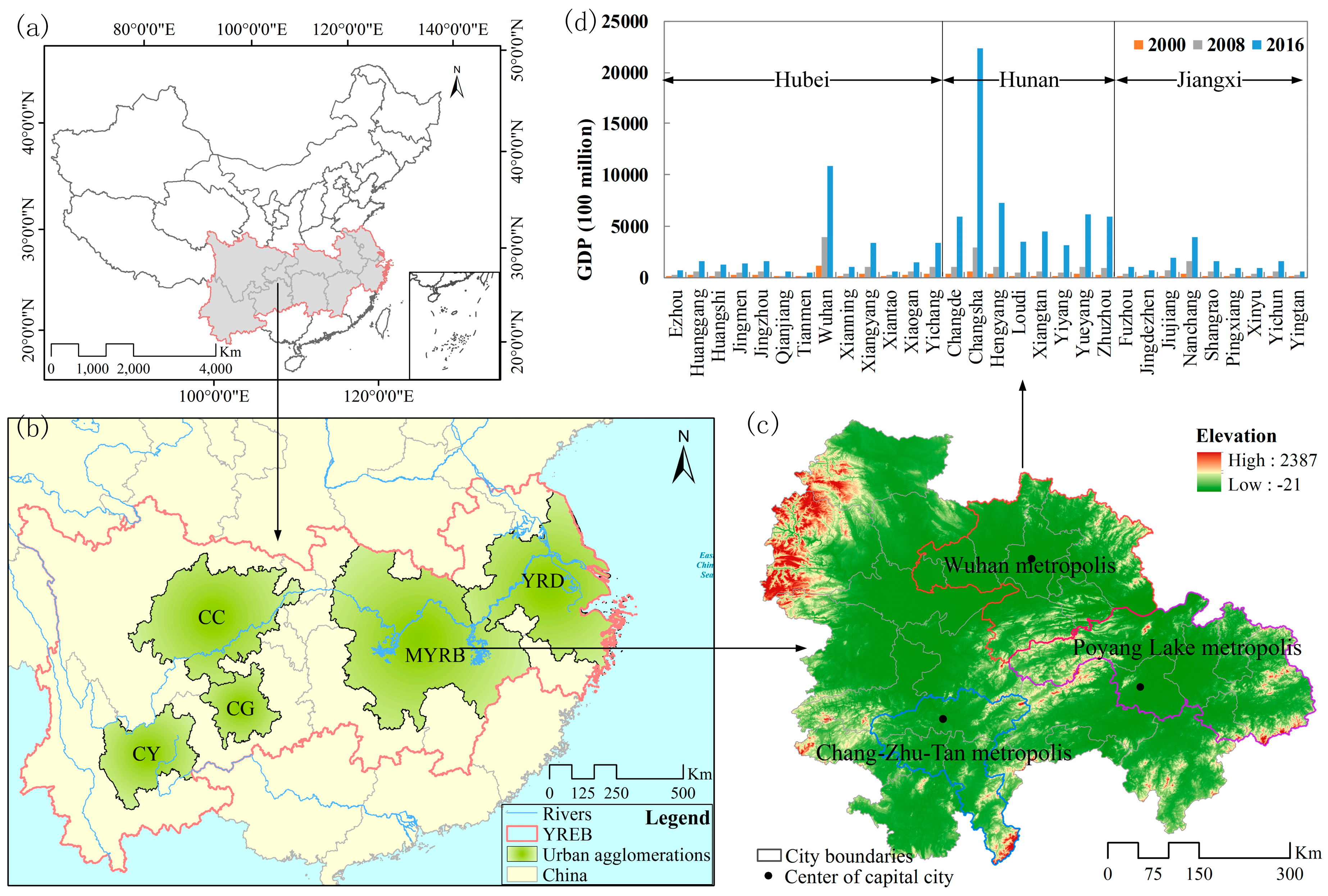
2.1. Study Area
2.2. Datasets
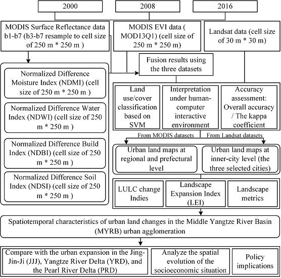
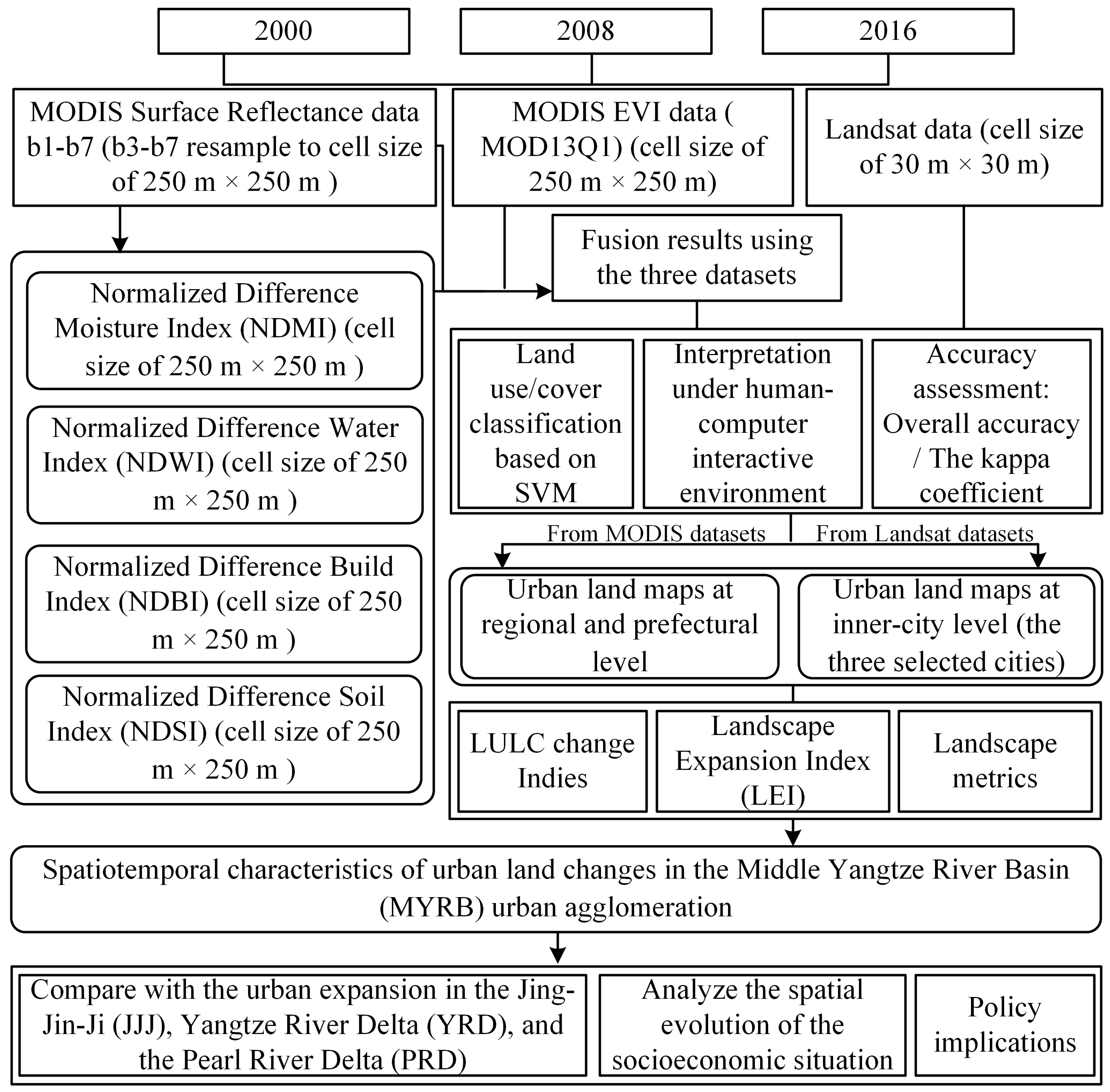
2.3. Data Processing
3. Methods
3.1. Qualitative Analysis of Urban Expansion
3.2. Urban Expansion Pattern
3.3. Landscape Metrics
3.4. Across-Scale Land-Cover Data Generation
4. Results
4.1. Urban Land Dynamic Change at the Regional Level
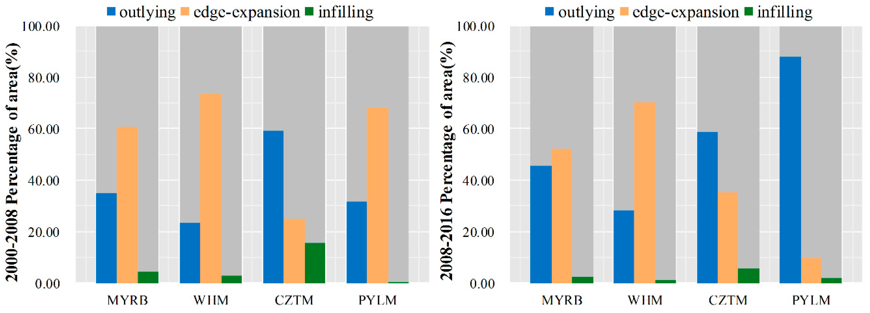
4.1.1. Urban Land Change in the MYRB Was Mainly Occupied by Outlying and Edge-Expansion
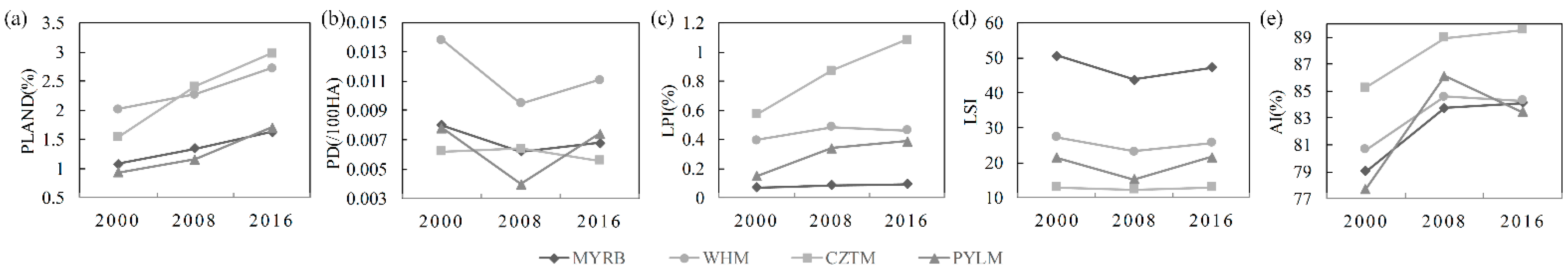
4.1.2. Urban Landscape Became More Aggregated in the Whole MYRB from 2000 to 2016
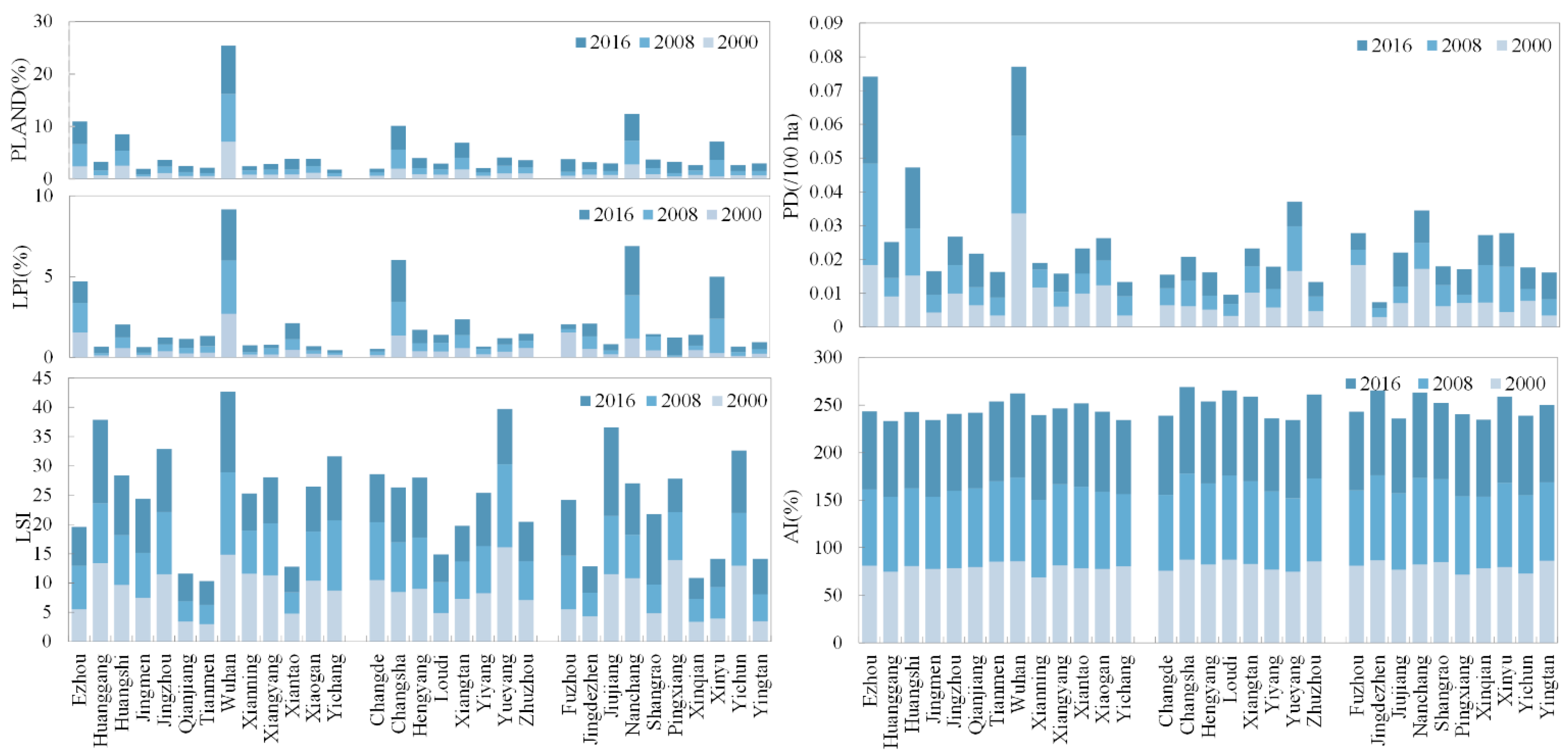
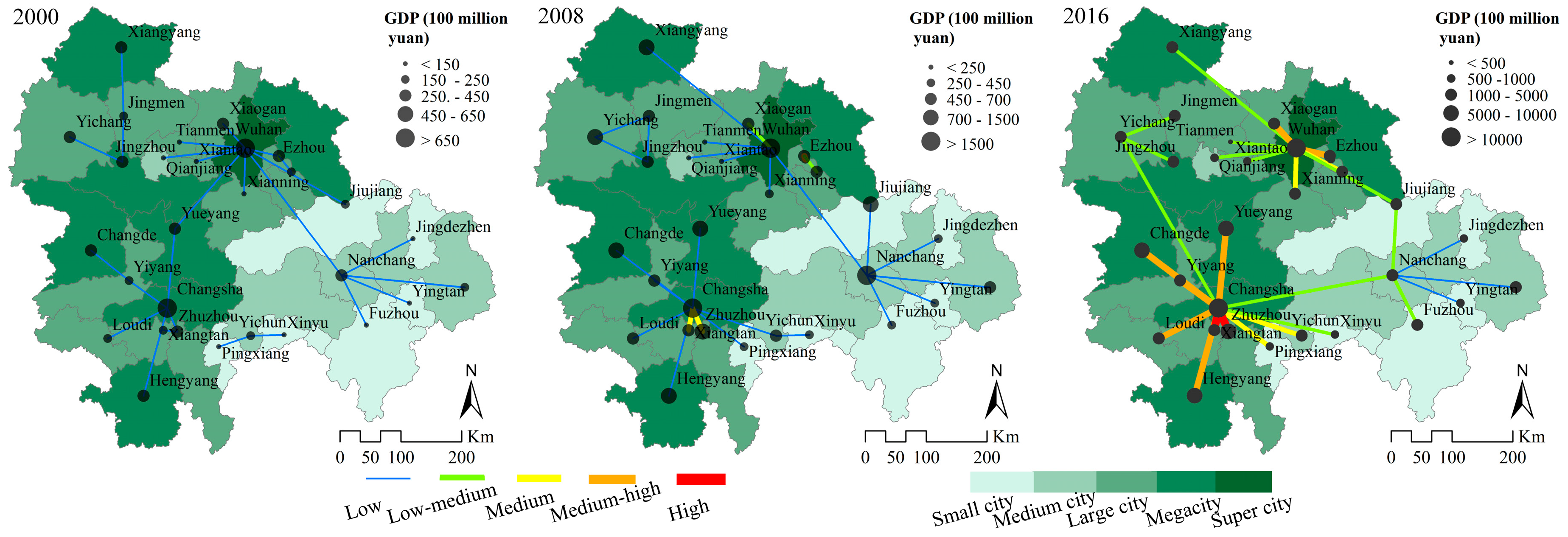
4.2. Urban Land Dynamic Change at the Prefectural Level
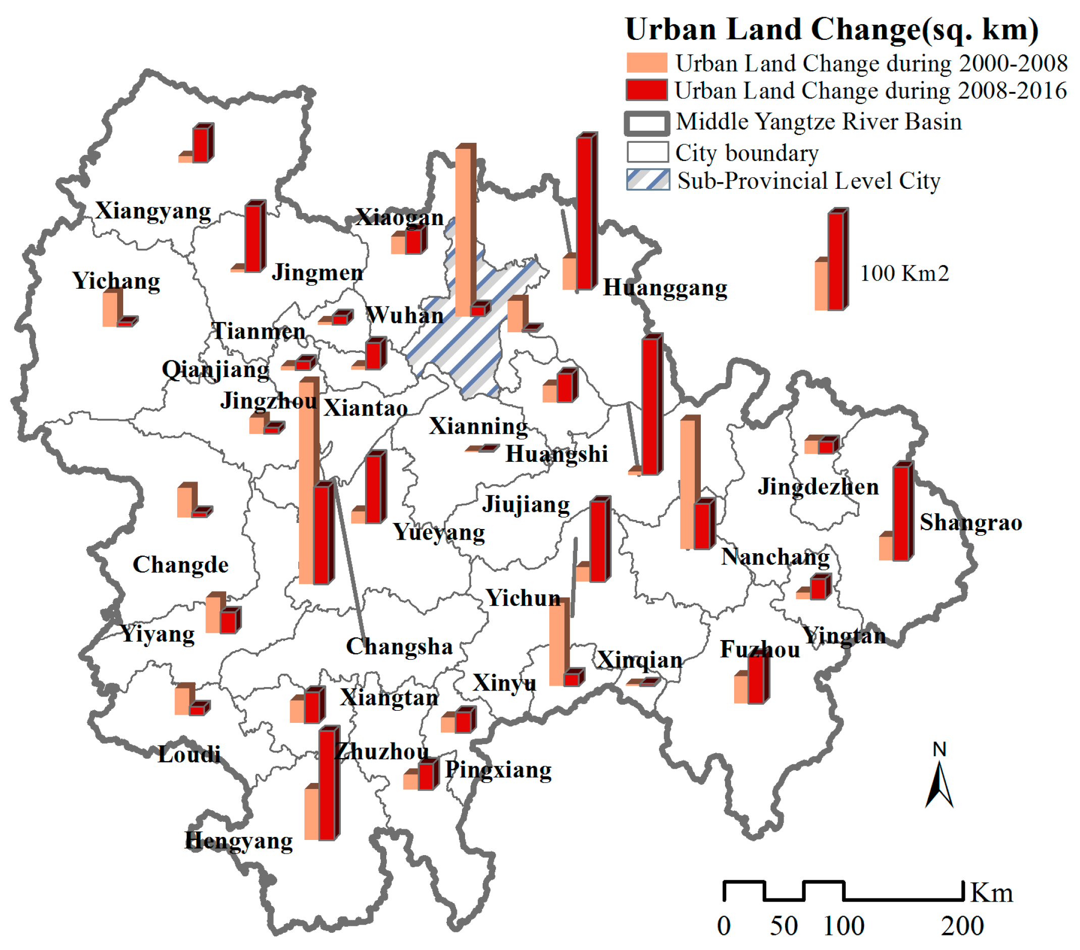
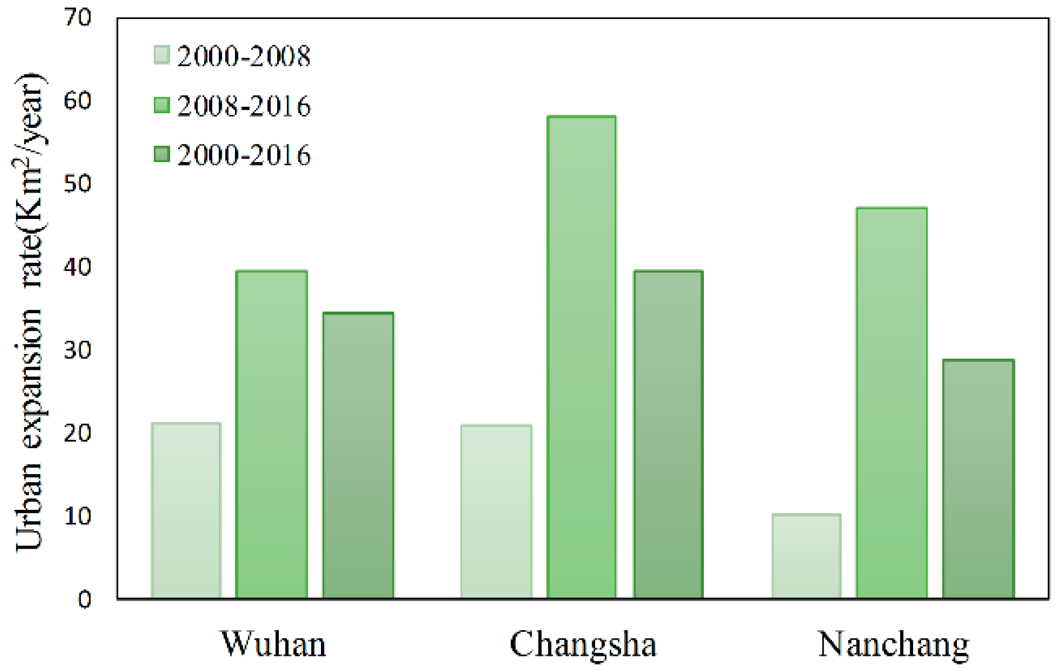
4.2.1. Medium-Small Cities Witnessed Faster Urban Expansion than Larger Cities
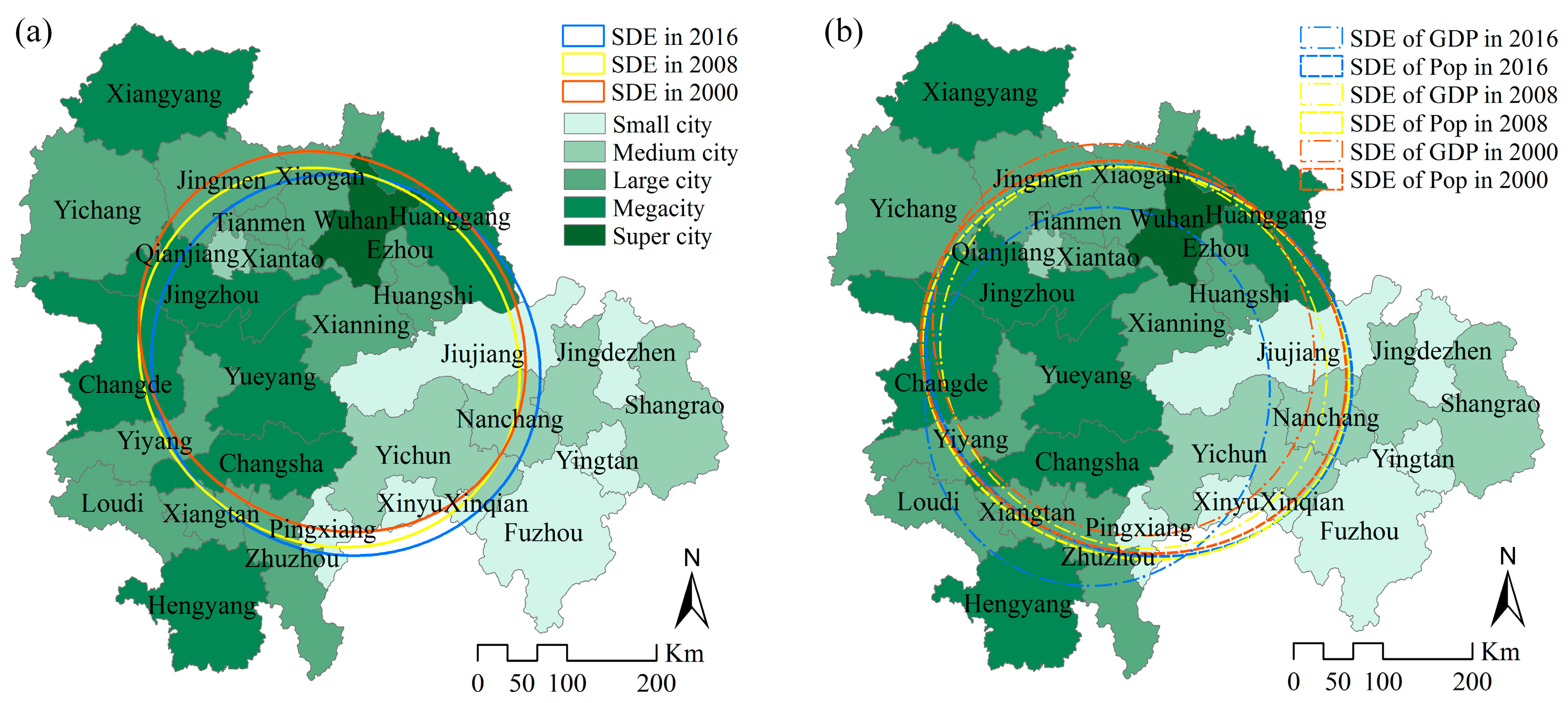
4.2.2. Different Urban Landscape Characteristics Exist among Cities in the MYRB
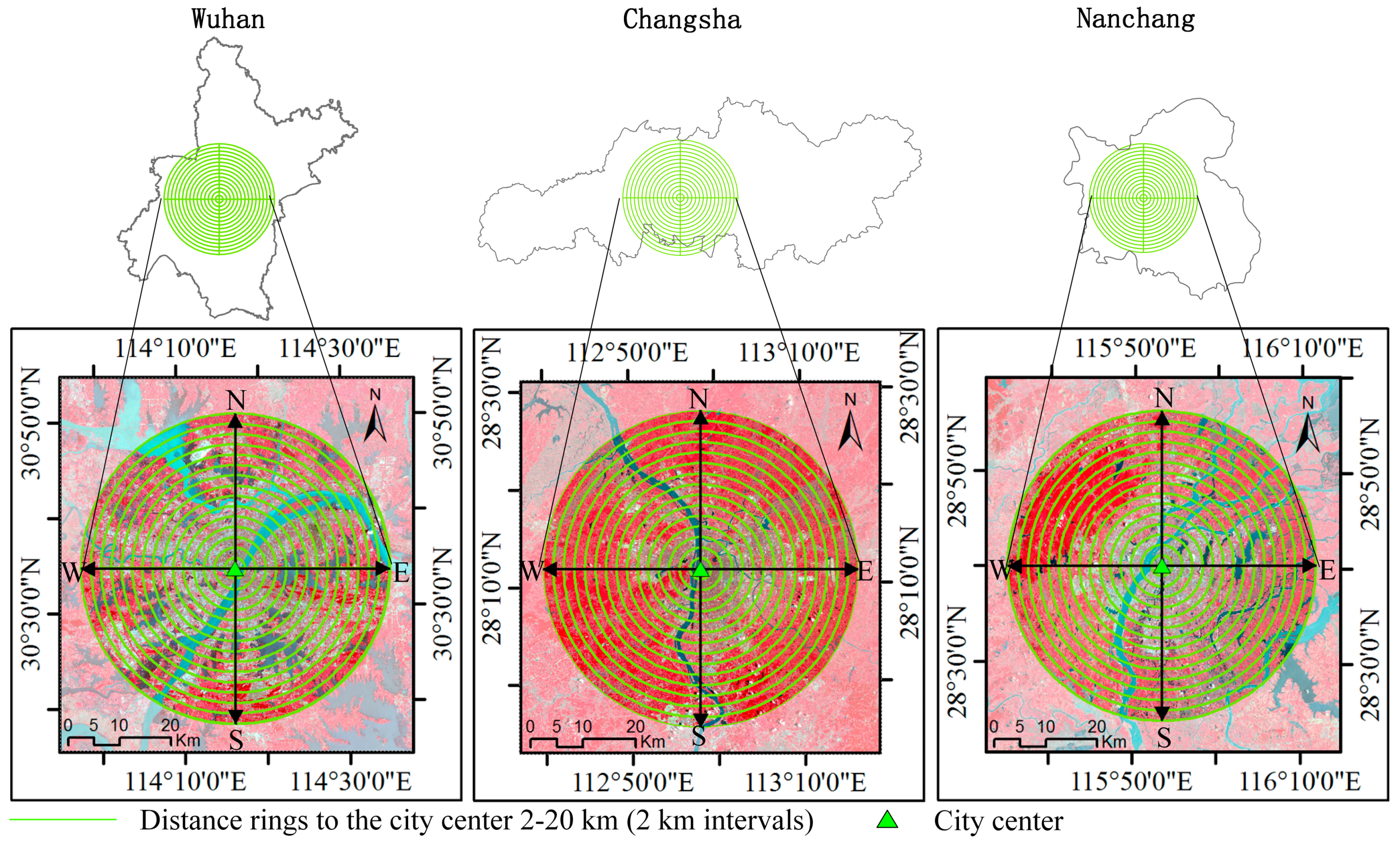
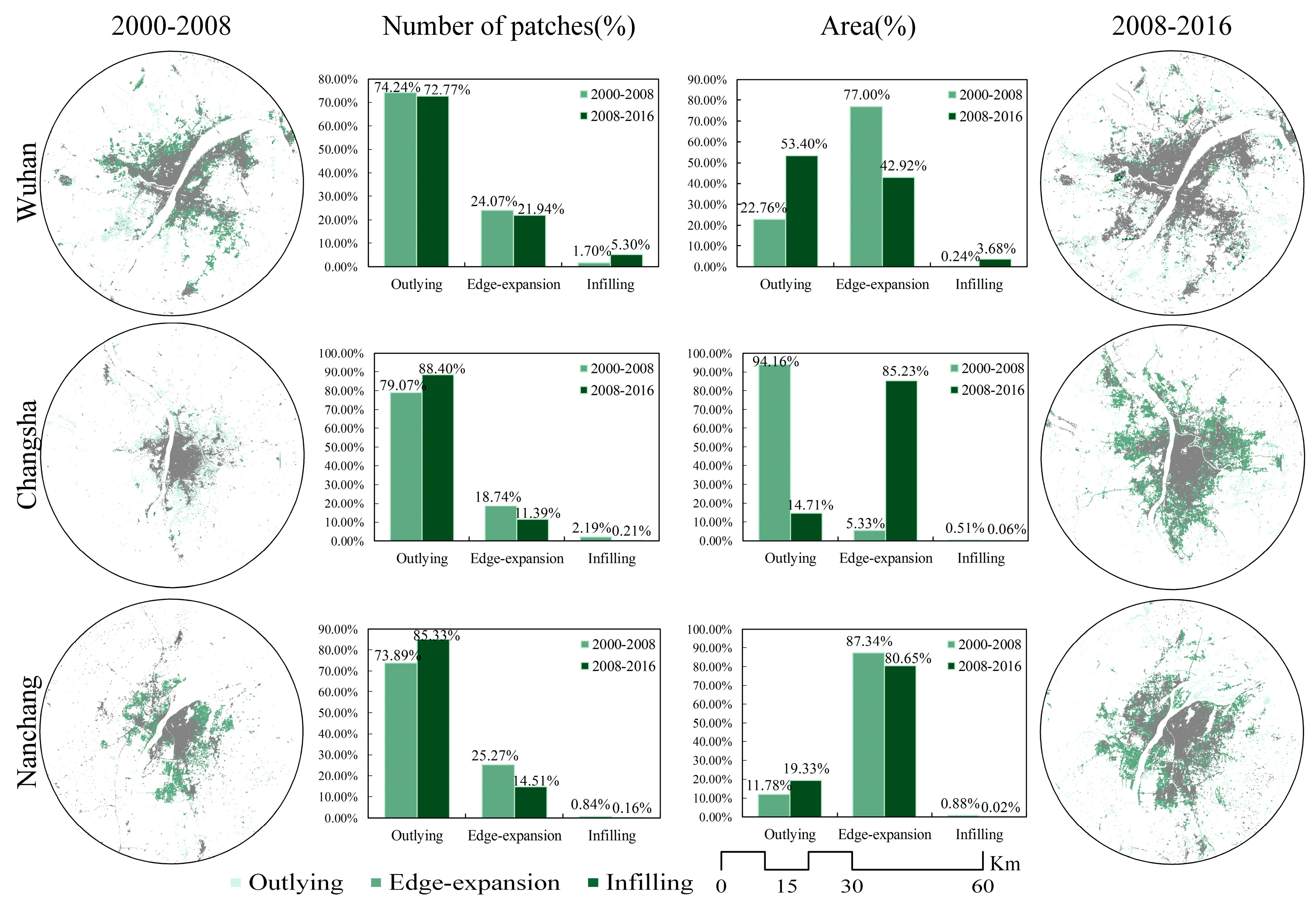
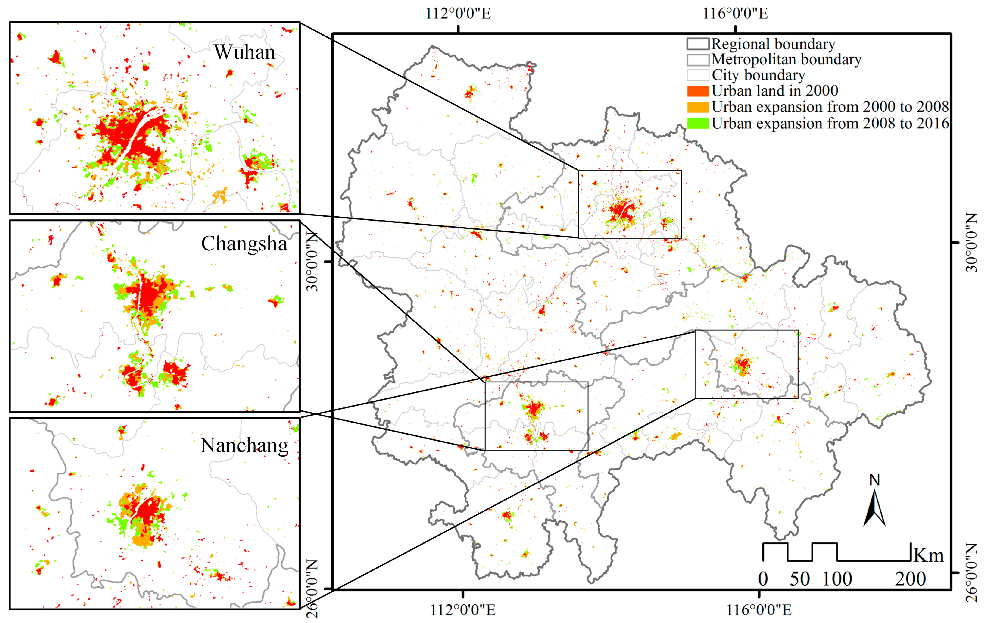
4.3. Urban Land Dynamic Change at the Inner-City Level
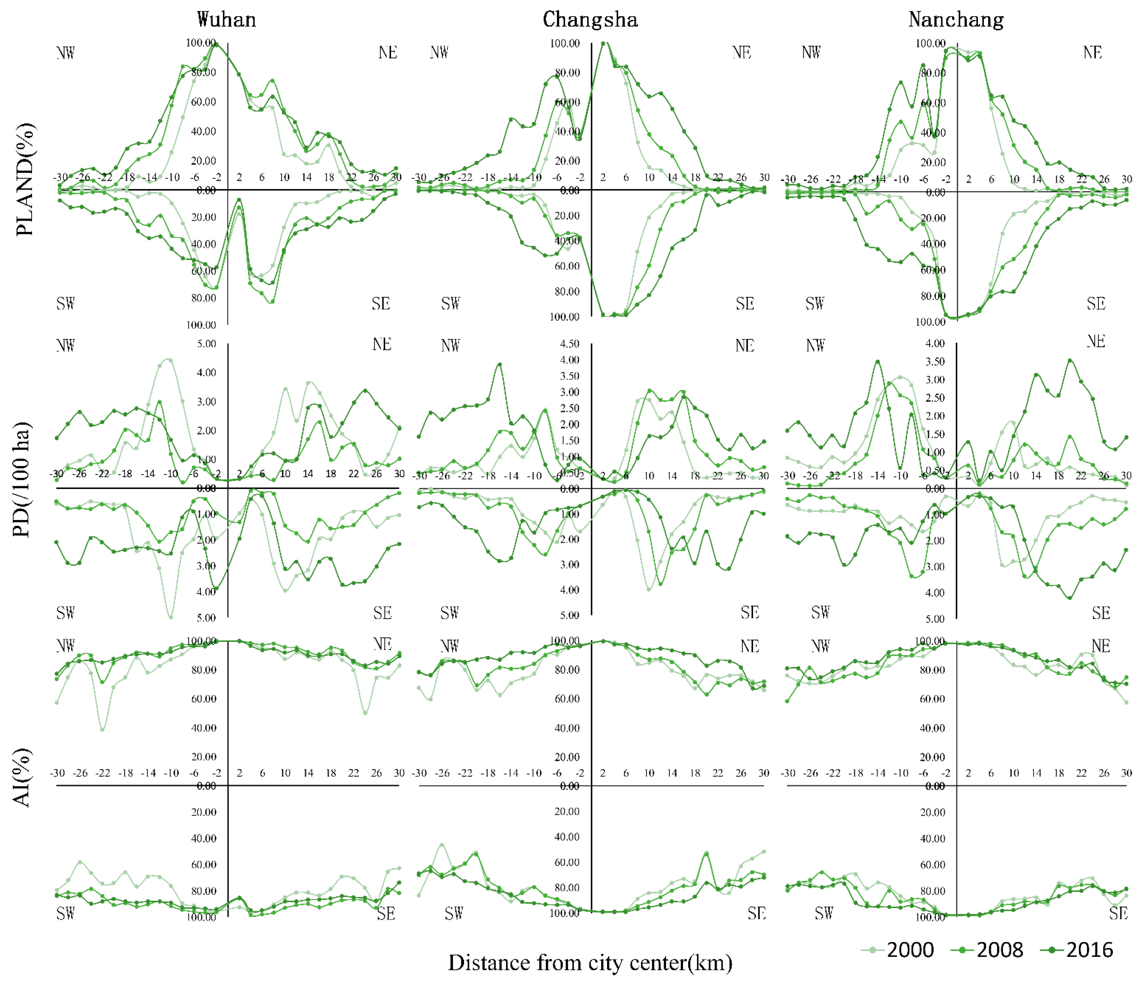
4.3.1. Outlying and Edge-Expansion Dominated the Spatial Pattern of Urban Land in the Three Capital Cities
4.3.2. The Existing Urban Land near the City Center Became Less Fragmented over Time
5. Discussion
5.1. Urban Expansion in the MYRB Urban Agglomeration Compared with Other Large Urban Agglomerations in China
5.2. Evolution of the Spatial Structure in the MYRB Urban Agglomeration
5.3. Implications for Regional Development Strategies
5.4. Limitations and Future Perspectives
6. Conclusions
Acknowledgments
Author Contributions
Conflicts of Interest
References
- Sun, C.; Wu, Z.F.; Lv, Z.Q.; Yao, N.; Wei, J.B. Quantifying different types of urban growth and the change dynamic in Guangzhou using multi-temporal remote sensing data. Int. J. Appl. Earth Obs. 2013, 21, 409–417. [Google Scholar] [CrossRef]
- Kuang, W.H.; Liu, J.Y.; Dong, J.W.; Chi, W.F.; Zhang, C. The rapid and massive urban and industrial land expansions in China between 1990 and 2010: A CLUD-based analysis of their trajectories, patterns, and drivers. Landsc. Urban Plan. 2016, 145, 21–33. [Google Scholar] [CrossRef]
- Kaza, N. The changing urban landscape of the continental United States. Landsc. Urban Plan. 2013, 110, 74–86. [Google Scholar] [CrossRef]
- Montgomery, M.R. The urban transformation of the developing world. Science 2008, 319, 761–764. [Google Scholar] [CrossRef] [PubMed]
- Bai, X.M.; Shi, P.J.; Liu, Y.S. Realizing china’s urban dream. Nature 2014, 509. [Google Scholar] [CrossRef]
- Zeng, C.; Zhang, M.D.; Cui, J.X.; He, S.W. Monitoring and modeling urban expansion-a spatially explicit and multi-scale perspective. Cities 2015, 43, 92–103. [Google Scholar] [CrossRef]
- Li, X.C.; Liu, X.P.; Gong, P. Integrating ensemble-urban cellular automata model with an uncertainty map to improve the performance of a single model. Int. J. Geogr. Inf. Sci. 2015, 29, 762–785. [Google Scholar] [CrossRef]
- Song, W.; Pijanowski, B.C.; Tayyebi, A. Urban expansion and its consumption of high-quality farmland in Beijing, China. Ecol. Indic. 2015, 54, 60–70. [Google Scholar] [CrossRef]
- Li, X.M.; Zhou, W.Q.; Ouyang, Z.Y. Forty years of urban expansion in Beijing: What is the relative importance of physical, socioeconomic, and neighborhood factors? Appl. Geogr. 2013, 38, 1–10. [Google Scholar] [CrossRef]
- Zhao, M.Y.; Cai, H.Y.; Qiao, Z.; Xu, X.L. Influence of urban expansion on the urban heat island effect in Shanghai. Int. J. Geogr. Inf. Sci. 2016, 30, 2421–2441. [Google Scholar] [CrossRef]
- Zhao, S.Q.; Da, L.J.; Tang, Z.Y.; Fang, H.J.; Song, K.; Fang, J.Y. Ecological consequences of rapid urban expansion: Shanghai, China. Front. Ecol. Environ. 2006, 4, 341–346. [Google Scholar] [CrossRef]
- Li, H.; Wei, Y.H.D.; Huang, Z.J. Urban land expansion and spatial dynamics in globalizing Shanghai. Sustainability 2014, 6, 8856–8875. [Google Scholar] [CrossRef]
- Li, L.W.; Lu, D.S.; Kuang, W.H. Examining urban impervious surface distribution and its dynamic change in Hangzhou metropolis. Remote Sens. 2016, 8. [Google Scholar] [CrossRef]
- Yue, W.Z.; Liu, Y.; Fan, P.L. Measuring urban sprawl and its drivers in large Chinese cities: The case of Hangzhou. Land Use Policy 2013, 31, 358–370. [Google Scholar] [CrossRef]
- Fan, F.L.; Wang, Y.P.; Qiu, M.H.; Wang, Z.S. Evaluating the temporal and spatial urban expansion patterns of Guangzhou from 1979 to 2003 by remote sensing and GIS methods. Int. J. Geogr. Inf. Sci. 2009, 23, 1371–1388. [Google Scholar] [CrossRef]
- Ma, Y.L.; Xu, R.S. Remote sensing monitoring and driving force analysis of urban expansion in Guangzhou City, China. Habitat. Int. 2010, 34, 228–235. [Google Scholar] [CrossRef]
- Tian, G.J.; Jiang, J.; Yang, Z.F.; Zhang, Y.Q. The urban growth, size distribution and spatio-temporal dynamic pattern of the Yangtze River Delta megalopolitan region, China. Ecol. Model. 2011, 222, 865–878. [Google Scholar] [CrossRef]
- Du, H.Y.; Wang, D.D.; Wang, Y.Y.; Zhao, X.L.; Qin, F.; Jiang, H.; Cai, Y.L. Influences of land cover types, meteorological conditions, anthropogenic heat and urban area on surface urban heat island in the Yangtze River Delta urban agglomeration. Sci. Total Environ. 2016, 571, 461–470. [Google Scholar] [CrossRef] [PubMed]
- Ye, L. Urban transformation and institutional policies: Case study of mega-region development in China’s Pearl River Delta. J. Urban Plan. Dev. 2013, 139, 292–300. [Google Scholar] [CrossRef]
- Wang, X.M.; Liao, J.B.; Zhang, J.; Shen, C.; Chen, W.H.; Xia, B.C.; Wang, T.J. A numeric study of regional climate change induced by urban expansion in the Pearl River Delta, China. J. Appl. Meteorol. Clim. 2014, 53, 346–362. [Google Scholar] [CrossRef]
- Haas, J.; Ban, Y.F. Urban growth and environmental impacts in Jing-Jin-Ji, the Yangtze River Delta and the Pearl River Delta. Int. J. Appl. Earth Obs. 2014, 30, 42–55. [Google Scholar] [CrossRef]
- Wu, W.J.; Zhao, S.Q.; Zhu, C.; Jiang, J.L. A comparative study of urban expansion in Beijing, Tianjin and Shijiazhuang over the past three decades. Landsc. Urban Plan. 2015, 134, 93–106. [Google Scholar] [CrossRef]
- Zhang, Z.X.; Li, N.; Wang, X.; Liu, F.; Yang, L.P. A comparative study of urban expansion in Beijing, Tianjin and Tangshan from the 1970s to 2013. Remote Sens. 2016, 8. [Google Scholar] [CrossRef]
- Zhou, K.H.; Liu, Y.L.; Tan, R.H.; Song, Y. Urban dynamics, landscape ecological security, and policy implications: A case study from the Wuhan area of central China. Cities 2014, 41, 141–153. [Google Scholar] [CrossRef]
- Peng, W.F.; Zhao, J.F.; Zhou, J.M.; Yang, C.J.; He, Z.W. Dynamic detection on urban sprawl based on RS and GIS: A case study of Chengdu City. In Proceedings of the 2008 International Workshop on Education Technology and Training and 2008 International Workshop on Geoscience and Remote Sensing, Shanghai, China, 21–22 December 2008. [Google Scholar]
- Tan, R.H.; Liu, Y.L.; Liu, Y.F.; He, Q.S.; Ming, L.C.; Tang, S.H. Urban growth and its determinants across the Wuhan urban agglomeration, central China. Habitat. Int. 2014, 44, 268–281. [Google Scholar] [CrossRef]
- Xu, M.; He, C.Y.; Liu, Z.F.; Dou, Y.Y. How did urban land expand in China between 1992 and 2015? A multi-scale landscape analysis. PLoS ONE 2016, 11. [Google Scholar] [CrossRef] [PubMed]
- Xu, T.; Ma, T.; Zhou, C.H.; Zhou, Y.K. Characterizing spatio-temporal dynamics of urbanization in China using time series of DMSP/OLS night light data. Remote Sens. 2014, 6, 7708–7731. [Google Scholar] [CrossRef]
- Huang, Z.J.; Wei, Y.D.; He, C.F.; Li, H. Urban land expansion under economic transition in China: A multilevel modeling analysis. Habitat. Int. 2015, 47, 69–82. [Google Scholar] [CrossRef]
- Ou, J.P.; Liu, X.P.; Li, X.; Chen, Y.M.; Li, J. Quantifying spatiotemporal dynamics of urban growth modes in metropolitan cities of China: Beijing, Shanghai, Tianjin, and Guangzhou. J. Urban Plan. D 2017, 143. [Google Scholar] [CrossRef]
- Quan, B.; Bai, Y.J.; Romkens, M.J.M.; Chang, K.T.; Song, H.; Guo, T.; Lei, S. Urban land expansion in Quanzhou City, China, 1995–2010. Habitat. Int. 2015, 48, 131–139. [Google Scholar] [CrossRef]
- Kuang, W.H.; Chi, W.F.; Lu, D.S.; Dou, Y.Y. A comparative analysis of megacity expansions in China and the U.S.: Patterns, rates and driving forces. Landsc. Urban Plan. 2014, 132, 121–135. [Google Scholar] [CrossRef]
- Yue, W.Z.; Zhang, L.L.; Liu, Y. Measuring sprawl in large Chinese cities along the Yangtze River via combined single and multidimensional metrics. Habitat. Int. 2016, 57, 43–52. [Google Scholar] [CrossRef]
- Usman, M.; Liedl, R.; Shahid, M.A.; Abbas, A. Land use/land cover classification and its change detection using multi-temporal MODIS NDVI data. J. Geogr. Sci. 2015, 25, 1479–1506. [Google Scholar] [CrossRef]
- Huang, X.M.; Schneider, A.; Friedl, M.A. Mapping sub-pixel urban expansion in China using MODIS and DMSP/OLS nighttime lights. Remote Sens. Environ. 2016, 175, 92–108. [Google Scholar] [CrossRef]
- Ying, Q.; Hansen, M.C.; Potapov, P.V.; Tyukavina, A.; Wang, L.; Stehman, S.V.; Moore, R.; Hancher, M. Global bare ground gain from 2000 to 2012 using Landsat imagery. Remote Sens. Environ. 2017, 194, 161–176. [Google Scholar] [CrossRef]
- Li, X.C.; Gong, P. An “exclusion-inclusion” framework for extracting human settlements in rapidly developing regions of China from Landsat images. Remote Sens. Environ. 2016, 186, 286–296. [Google Scholar] [CrossRef]
- Sun, Y.L.; Yang, X.H.; Wang, X.S.; Chen, J.J. Land use classification based on decision tree using MODIS data. Resour. Sci. 2007, 29, 169–174. [Google Scholar]
- National Development and Reform Commission. Available online: http://www.ndrc.gov.cn/zcfb/zcfbtz/201504/t20150416_688229.html (accessed on 26 September 2017).
- Gu, Q.W.; Wang, H.Q.; Zheng, Y.N.; Zhu, J.W.; Li, X.K. Ecological footprint analysis for urban agglomeration sustainability in the middle stream of the Yangtze River. Ecol. Model. 2015, 318, 86–99. [Google Scholar] [CrossRef]
- Fan, C.; Myint, W.; Rey, S.J.; Li, W.W. Time series evaluation of landscape dynamics using annual Landsat imagery and spatial statistical modeling: Evidence from the Phoenix metropolitan region. Int. J. Appl. Earth Obs. 2017, 58, 12–25. [Google Scholar] [CrossRef]
- Tan, B.; Morisette, J.T.; Wolfe, R.E.; Gao, F.; Ederer, G.A.; Nightingale, J.; Pedelty, J.A. An enhanced timesat algorithm for estimating vegetation phenology metrics from MODIS data. IEEE J. Stars 2011, 4, 361–371. [Google Scholar] [CrossRef]
- McFeeters, S.K. The use of the normalized difference water index (NDWI) in the delineation of open water features. Int. J. Remote Sens. 1996, 17, 1425–1432. [Google Scholar] [CrossRef]
- Dwyer, J.; Schmidt, G. The MODIS reprojection tool. Earth Sci. Satell. Remote Sens. Data Comput. Process. Tools 2006, 2. [Google Scholar] [CrossRef]
- Jin, Y.; Sung, S.; Lee, D.K.; Biging, G.S.; Jeong, S. Mapping deforestation in North Korea using phenology-based multi-index and random forest. Remote Sens. 2016, 8, 997. [Google Scholar] [CrossRef]
- Hall, D.K.; Riggs, G.A.; Salomonson, V.V. Development of methods for mapping global snow cover using moderate resolution imaging spectroradiometer data. Remote Sens. Environ. 1995, 54, 127–140. [Google Scholar] [CrossRef]
- Yang, C.K.; Tan, C.H.; Juan, C.H.; Lin, M.L. Characterizing the meso-scale enviromental thermal effects due to different landuse types using remote sensing techniques and indices in Taoyuan, North Taiwan. In Proceedings of the Geoscience and Remote Sensing Symposium, Boston, MA, USA, 7–11 July 2008. [Google Scholar]
- Zha, Y.; Gao, J.; Ni, S. Use of normalized difference built-up index in automatically mapping urban areas from TM imagery. Int. J. Remote Sens. 2003, 24, 583–594. [Google Scholar] [CrossRef]
- Cherkassky, V. The nature of statistical learning theory. IEEE Trans. Neural Netw. 1997, 8, 1564. [Google Scholar] [CrossRef] [PubMed]
- Google Earth. Available online: https://www.google.com/earth/ (accessed on 26 September 2017).
- Chance, E.W.; Cobourn, K.M.; Thomas, V.A.; Dawson, B.C.; Flores, A.N. Identifying irrigated areas in the Snake River Plain, Idaho: Evaluating performance across compositing algorithms, spectral indices, and sensors. Remote Sens. 2017, 9, 546. [Google Scholar] [CrossRef]
- Pan, X.Z.; Uchida, S.; Liang, Y.; Hirano, A.; Sun, B. Discriminating different landuse types by using multitemporal NDXI in a rice planting area. Int. J. Remote Sens. 2010, 31, 585–596. [Google Scholar] [CrossRef]
- Foody, G.M. Status of land cover classification accuracy assessment. Remote Sens. Environ. 2002, 80, 185–201. [Google Scholar] [CrossRef]
- Zhang, Q.W.; Su, S.L. Determinants of urban expansion and their relative importance: A comparative analysis of 30 major metropolitans in China. Habitat. Int. 2016, 58, 89–107. [Google Scholar] [CrossRef]
- Liu, X.P.; Li, X.; Chen, Y.M.; Tan, Z.Z.; Li, S.Y.; Ai, B. A new landscape index for quantifying urban expansion using multi-temporal remotely sensed data. Landsc. Ecol. 2010, 25, 671–682. [Google Scholar] [CrossRef]
- Mcgarigal, K.; Marks, B.J. Fragstats: Spatial Analysis Program for Quantifying Landscape Structure; USDA Forest Service: Washington, DC, USA, 1995; p. 351.
- Jiang, L.; Deng, X.Z.; Seto, K.C. Multi-level modeling of urban expansion and cultivated land conversion for urban hotspot counties in China. Landsc. Urban Plan. 2012, 108, 131–139. [Google Scholar] [CrossRef]
- Wang, L.; Li, C.C.; Ying, Q.; Cheng, X.; Wang, X.Y.; Li, X.Y.; Hu, L.Y.; Liang, L.; Yu, L.; Huang, H.B.; et al. China’s urban expansion from 1990 to 2010 determined with satellite remote sensing. Chin. Sci. Bull. 2012, 57, 2802–2812. [Google Scholar] [CrossRef]
- Qi, W.; Liu, S.H.; Jin, H.R. Applicability of the new standard of city-size classification in China. Prog. Geogr. 2016, 35. [Google Scholar] [CrossRef]
- Jiao, L.M. Urban land density function: A new method to characterize urban expansion. Landsc. Urban Plan. 2015, 139, 26–39. [Google Scholar] [CrossRef]
- Li, H.; Wei, Y.D.; Liao, F.H.; Huang, Z.J. Administrative hierarchy and urban land expansion in transitional China. Appl. Geogr. 2015, 56, 177–186. [Google Scholar] [CrossRef]
- Yi, K.; Zeng, Y.; Wu, B. Mapping and evaluation the process, pattern and potential of urban growth in China. Appl. Geogr. 2016, 71, 44–55. [Google Scholar] [CrossRef]
- Zhang, Y.; He, L.; Jin, W.; Wu, K.; Xu, Y.; Yu, F. Quantitative analysis of the urban expansion models in Changsha-Zhuzhou-Xiangtan metroplan areas. Sci. Geogr. Sin. 2012, 32, 5. [Google Scholar] [CrossRef]
- Liu, L.; Leung, Y. A study of urban expansion of prefectural-level cities in south China using night-time light images. Int. J. Remote Sens. 2015, 36, 5557–5575. [Google Scholar] [CrossRef]
- Jing, L.P.; Zhong, X.M.; Huang, W.H.; Liu, Y.; Wang, M.; Miao, Z.; Zhang, X.P.; Zou, J.; Zheng, B.W.; Chen, C.; et al. HPV genotypes and associated cervical cytological abnormalities in women from the Pearl River Delta region of Guangdong province, China: A cross-sectional study. BMC Infect. Dis. 2014, 14, 388. [Google Scholar] [CrossRef] [PubMed]
- Lefever, D.W. Measuring geographic concentration by means of the standard deviational ellipse. Am. J. Sociol. 1926, 32, 88–94. [Google Scholar] [CrossRef]
- Boukebbab, S.; Boulahlib, M.S. The spatial interactions using the gravity model: Application at the evaluation of transport efficiency at Constantine City, Algeria. Theory Eng. Complex Syst. Dependability 2015, 365, 35–44. [Google Scholar] [CrossRef]
- Gangopadhyay, K.; Basu, B. City size distributions for India and China. Physics A 2009, 388, 2682–2688. [Google Scholar] [CrossRef]
- Wang, H.J.; Lan, Z.M.; Jin, H.; Zhang, C. Study on the spatial evolution of urban system in the middle reaches of Yangtze River urban agglomeration based on night light data. Inquiry Econ. Issues 2017, 3, 107–114. [Google Scholar]
- Deng, X.Z.; Huang, J.K.; Rozelle, S.; Zhang, J.P.; Li, Z.H. Impact of urbanization on cultivated land changes in China. Land Use Policy 2015, 45, 1–7. [Google Scholar] [CrossRef]
- Fang, C.L.; Zhou, C.H.; Wang, Z.P. Sustainable development strategy and priorities of spatially differentiated development of urban agglomerations along the Yangtze River Economic Belt. Prog. Geogr. 2015, 34, 1398–1408. [Google Scholar] [CrossRef]
- The State Council Information Office of the People’s Republic of China. Available online: http://www.scio.gov.cn/34473/34515/Document/1535229/1535229.htm (accessed on 26 September 2017).
- Yu, S.; Sun, Z.; Guo, H.; Zhao, X.; Sun, L.; Wu, M. Monitoring and analyzing the spatial dynamics and patterns of megacities along the Maritime Silk Road. J. Remote Sens. 2017, 21. [Google Scholar] [CrossRef]
- Kusaka, H.; Kimura, F. Coupling a single-layer urban canopy model with a simple atmospheric model: Impact on urban heat island simulation for an idealized case. J. Meteorol. Soc. Jpn. 2004, 82, 67–80. [Google Scholar] [CrossRef]
- Miao, S.G.; Chen, F.; Lemone, M.A.; Tewari, M.; Li, Q.C.; Wang, Y.C. An observational and modeling study of characteristics of urban heat island and boundary layer structures in Beijing. J. Appl. Meteorol. Clim. 2009, 48, 484–501. [Google Scholar] [CrossRef]
- Fang, C.L.; Yu, D.L. Urban agglomeration: An evolving concept of an emerging phenomenon. Landsc. Urban Plan. 2017, 162, 126–136. [Google Scholar] [CrossRef]
- Lu, S.S.; Guan, X.L.; Yu, D.L.; Deng, Y.; Zhou, L.J. Multi-scale analysis of regional inequality based on spatial field model: A case study of China from 2000 to 2012. ISPRS Int. Geo-Inf. 2015, 4, 1982–2003. [Google Scholar] [CrossRef]
- Gao, B.; Huang, Q.X.; He, C.Y.; Sun, Z.X.; Zhang, D. How does sprawl differ across cities in China? A multi-scale investigation using nighttime light and census data. Landsc. Urban Plan. 2016, 148, 89–98. [Google Scholar] [CrossRef]
- Lin, B.B.; Fuller, R.A. Sharing or sparing? How should we grow the world’s cities? J. Appl. Ecol. 2013, 50, 1161–1168. [Google Scholar] [CrossRef]


| MODIS Data | ||||||
| Product name | MOD09A1 | MOD09Q1 | MOD13Q1 | |||
| Tile | h27v05, h27v06, h28v05, h28v06 | |||||
| Band | bands 3–7 | bands 1–2 | EVI | |||
| Resolution | 500 m | 250 m | 250 m | |||
| DOY (Date) | 2000 | 201 (20 July–27 July) | 201 (20 July–27 July) | 001 (1 January–8 January), 097 (7 April–14 April), 193 (12 July–19 July), 273 (30 September–7 October) | ||
| 2008 | 217 (5 August–12 August) | 217 (5 August–12 August) | 001 (1 January–8 January), 097 (7 April–14 April), 193 (12 July–19 July), 273 (30 September–7 October) | |||
| 2016 | 201 (20 July–27 July) | 201 (20 July–27 July) | 001 (1 January–8 January), 097 (7 April–14 April), 193 (12 July–19 July), 273 (30 September–7 October) | |||
| Landsat data | ||||||
| Periods | Wuhan | Changsha | Nanchang | |||
| Path/row | DOY (Date) | Path/row | DOY (Date) | Path/row | DOY (Date) | |
| 2000 | 123/38 123/39 122/39 | 257 (14 September 2000) 257 (14 September 2000) 282 (9 October 2000) | 122/40 123/40 123/41 124/40 124/41 | 258 (15 September 2000) 267 (24 September 2001) 251 (8 September 2001) 258 (15 September 2001) 258 (15 September 2001) | 121/40 122/40 | 253 (10 September 2001) 258 (15 September 2000) |
| 2008 | 123/38 123/39 122/39 | 212 (31 July 2007) 212 (31 July 2007) 189 (8 July 2007) | 123/40 123/41 124/40 124/41 | 212 (31 July 2007) 263 (20 September 2008) 219 (7 August 2007) 219 (7 August 2007) | 121/40 122/40 | 206 (25 July 2007) 232 (20 August 2008) |
| 2016 | 123/38 123/39 122/39 | 205 (24 July 2016) 205 (24 July 2016) 214 (2 August 2016) | 123/40 123/41 124/40 124/41 | 205 (24 July 2016) 205 (24 July 2016) 212 (31 July 2016) 212 (31 July 2016) | 121/40 122/40 | 175 (24 June 2016) 134 (14 May 2016) |
| 2000 | 2008 | 2016 | ||||||||||
|---|---|---|---|---|---|---|---|---|---|---|---|---|
| MOD | Landsat | MOD | Landsat | MOD | Landsat | |||||||
| WH | CS | NC | WH | CS | NC | WH | CS | NC | ||||
| CE (%) | 6.27 | 1.87 | 2.23 | 2.32 | 3.09 | 1.57 | 1.39 | 1.32 | 2.67 | 1.73 | 1.94 | 1.50 |
| OE (%) | 9.13 | 2.48 | 4.07 | 2.43 | 6.30 | 1.32 | 3.63 | 2.28 | 3.63 | 2.71 | 3.83 | 2.28 |
| OA (%) | 78.34 | 89.01 | 89.10 | 89.52 | 90.74 | 94.68 | 89.56 | 92.09 | 92.50 | 93.10 | 89.51 | 89.30 |
| KC | 0.70 | 0.88 | 0.88 | 0.89 | 0.87 | 0.92 | 0.88 | 0.89 | 0.90 | 0.88 | 0.88 | 0.88 |
| Acronym | Name of Landscape Metric (Units) | Description | |
|---|---|---|---|
| Area metrics | PLAND | Percentage of Landscape (%) | The percentage the landscape of the corresponding patch type. |
| LPI | Largest patch index (%) | Proportion of total area occupied by the largest patch of a patch type. | |
| Shape metrics | LSI | Landscape Shape Index | Provides a standardized measure of total edge or edge density that adjusts for the size of the landscape. |
| Density metrics | PD | Patch density (Number/100 ha) | The number of patches of per 100 ha. |
| AI | Aggregation Index (%) | The degree of fragmentation of a land cover type or a landscape. |
| City Size | Urban Population (Million) | City Count |
|---|---|---|
| Super city | >10 | 1 |
| Megacity | 5–10 | 7 |
| Large city | 1–5 | 12 |
| Medium city | 0.5–1 | 4 |
| Small city | <0.5 | 7 |
| Year/Period | Super-City | Megacity | Large City | Medium City | Small City |
|---|---|---|---|---|---|
| AI (km2/year) | |||||
| 2000–2008 | 21.646 | 32.098 | 17.430 | 15.952 | 19.509 |
| 2008–2016 | 1.234 | 33.179 | 22.308 | 29.346 | 32.642 |
| 2000–2016 | 11.440 | 32.639 | 19.869 | 22.649 | 26.076 |
| AGR (%) | |||||
| 2000–2008 | 3.206 | 2.449 | 1.825 | 3.020 | 4.751 |
| 2008–2016 | 0.158 | 2.111 | 2.008 | 4.199 | 5.364 |
| 2000–2016 | 1.671 | 2.279 | 1.916 | 3.608 | 5.057 |
| Rs (%) | |||||
| 2000–2008 | 3.590 | 2.669 | 1.946 | 3.359 | 5.620 |
| 2008–2016 | 0.159 | 2.021 | 2.155 | 4.871 | 6.487 |
| 2000–2016 | 1.898 | 2.714 | 2.218 | 4.769 | 7.513 |
| Is (%) | |||||
| 2000–2008 | 0.256 | 0.029 | 0.018 | 0.031 | 0.036 |
| 2008–2016 | 0.015 | 0.030 | 0.022 | 0.058 | 0.061 |
| 2000–2016 | 0.135 | 0.029 | 0.020 | 0.045 | 0.049 |
© 2017 by the authors. Licensee MDPI, Basel, Switzerland. This article is an open access article distributed under the terms and conditions of the Creative Commons Attribution (CC BY) license (http://creativecommons.org/licenses/by/4.0/).
Share and Cite
Liu, D.; Chen, N. Satellite Monitoring of Urban Land Change in the Middle Yangtze River Basin Urban Agglomeration, China between 2000 and 2016. Remote Sens. 2017, 9, 1086. https://doi.org/10.3390/rs9111086
Liu D, Chen N. Satellite Monitoring of Urban Land Change in the Middle Yangtze River Basin Urban Agglomeration, China between 2000 and 2016. Remote Sensing. 2017; 9(11):1086. https://doi.org/10.3390/rs9111086
Chicago/Turabian StyleLiu, Dandan, and Nengcheng Chen. 2017. "Satellite Monitoring of Urban Land Change in the Middle Yangtze River Basin Urban Agglomeration, China between 2000 and 2016" Remote Sensing 9, no. 11: 1086. https://doi.org/10.3390/rs9111086
APA StyleLiu, D., & Chen, N. (2017). Satellite Monitoring of Urban Land Change in the Middle Yangtze River Basin Urban Agglomeration, China between 2000 and 2016. Remote Sensing, 9(11), 1086. https://doi.org/10.3390/rs9111086