SCaMF–RM: A Fused High-Resolution Land Cover Product of the Rocky Mountains


Abstract
:
1. Introduction
2. Materials and Methods
2.1. Region of Interest
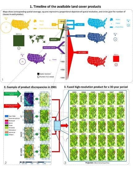
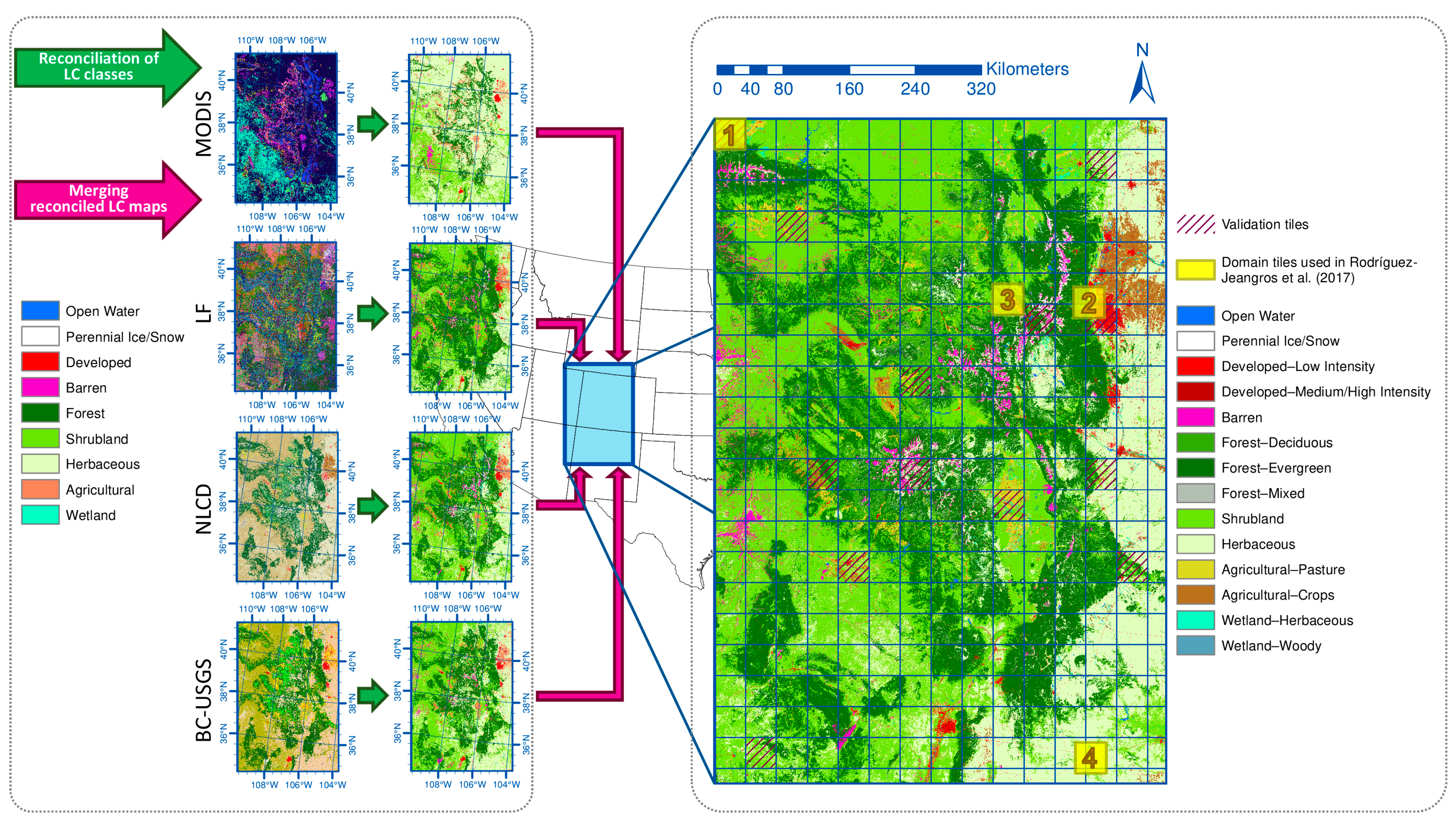
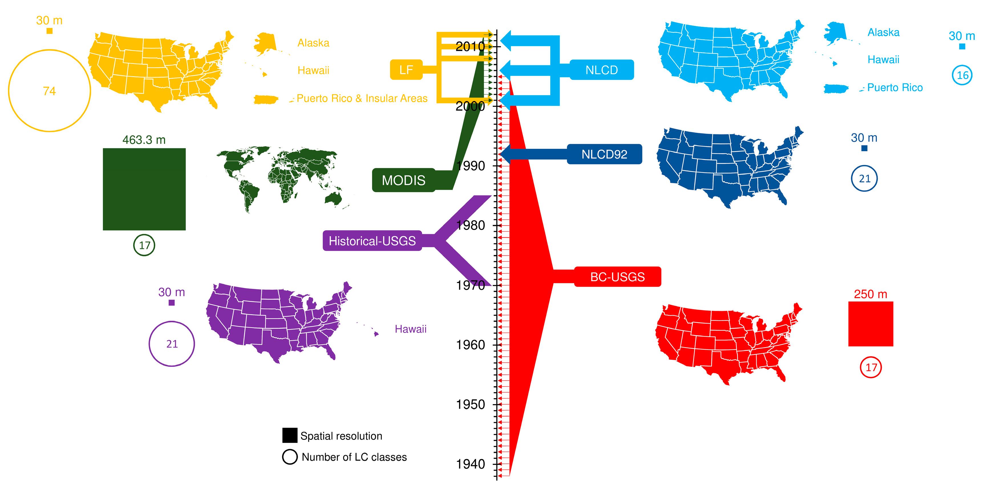
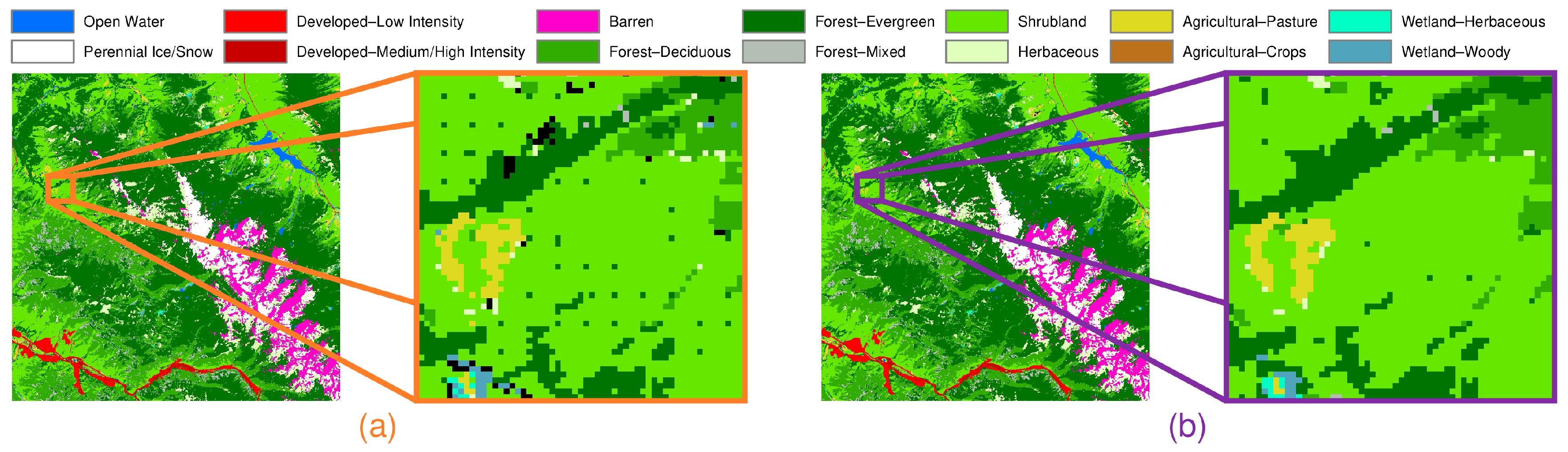
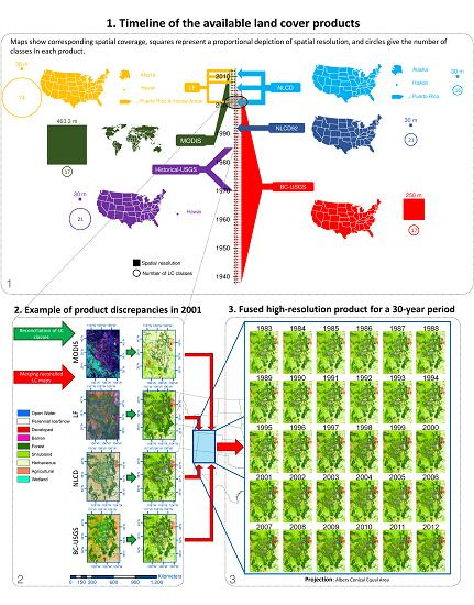
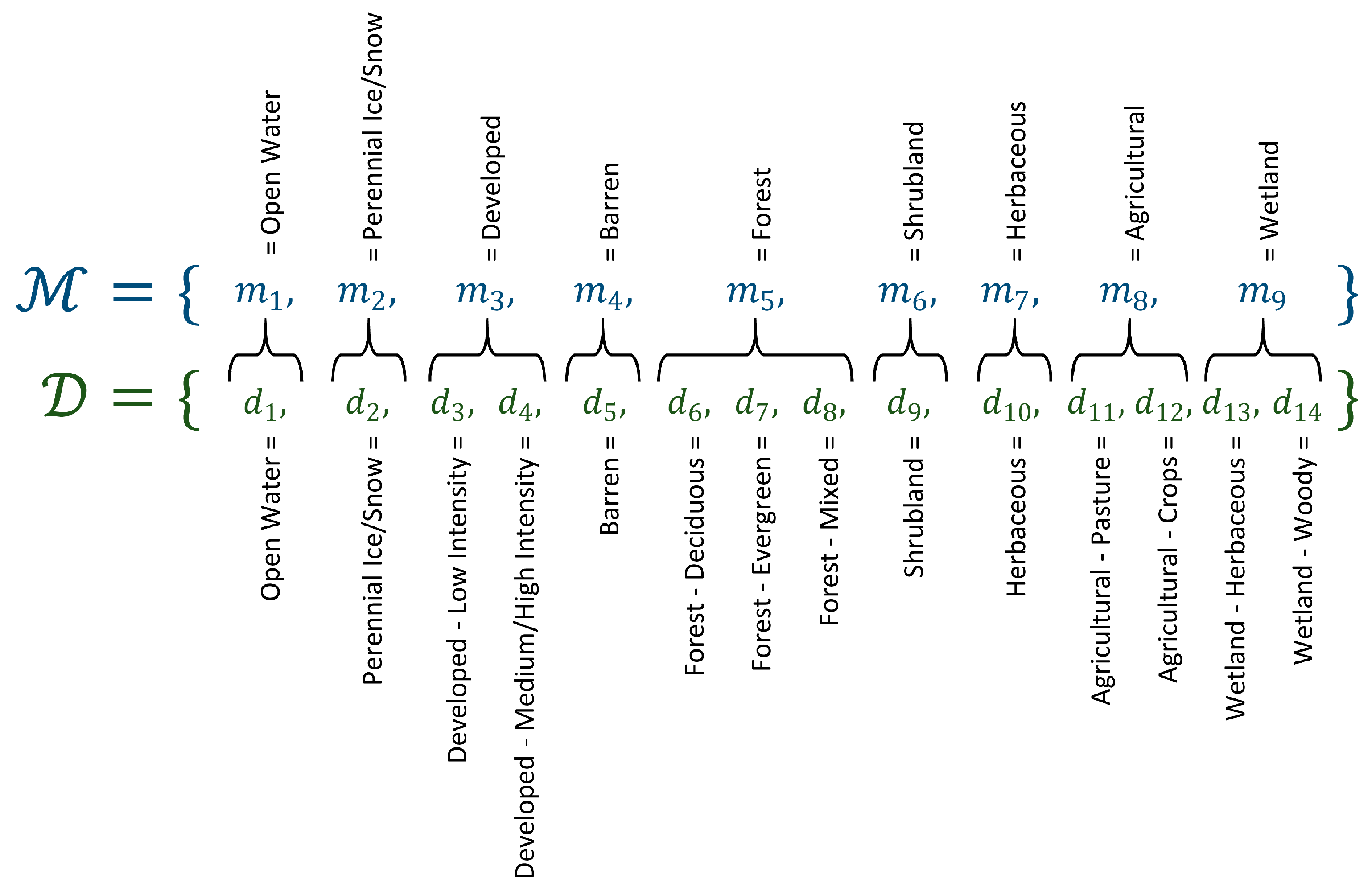
2.2. Land Cover Datasets
2.3. SCaMF Methodology and Proposed Modifications
2.4. Large-Scale Considerations
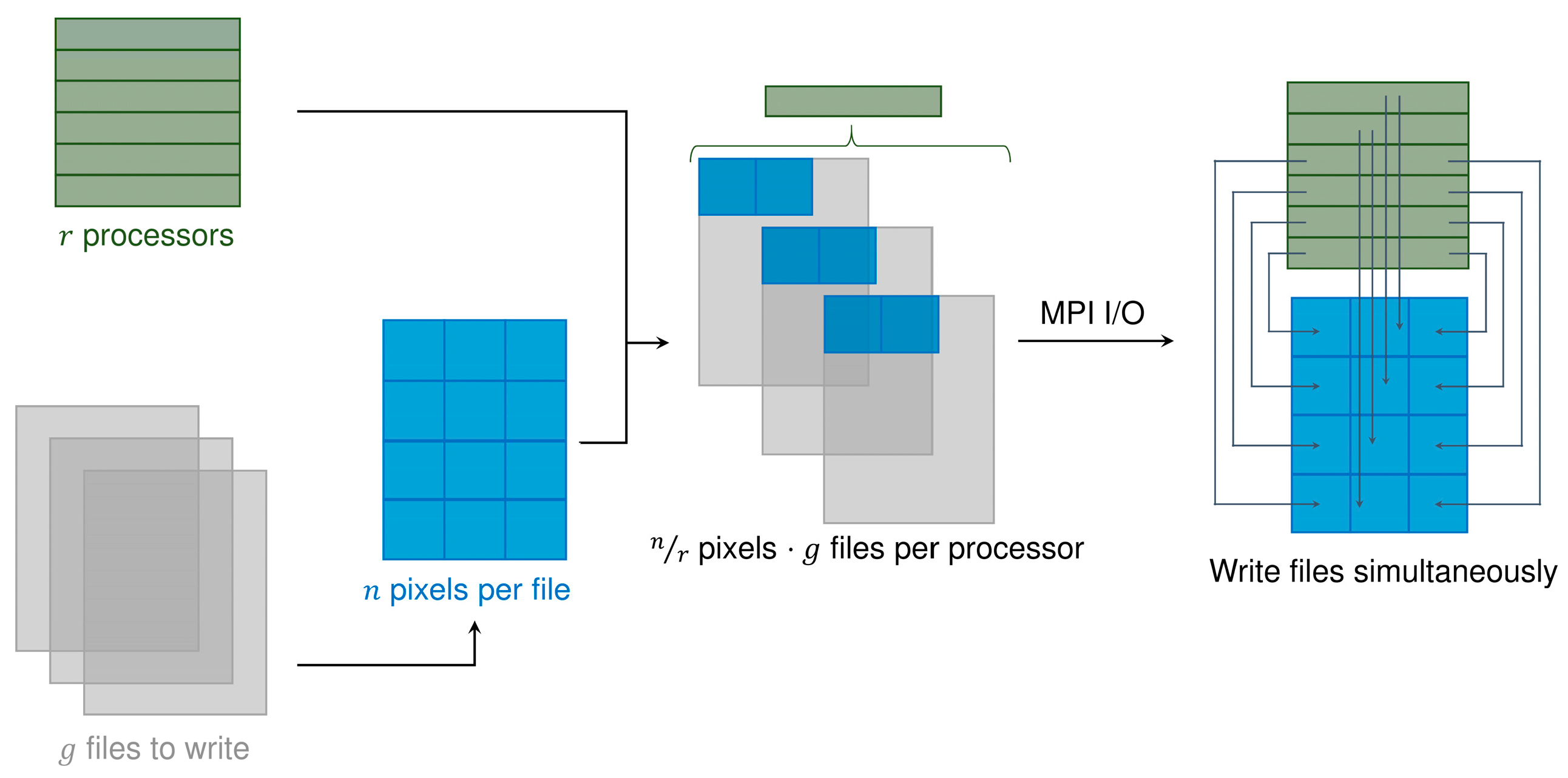
2.4.1. Computational Implementation
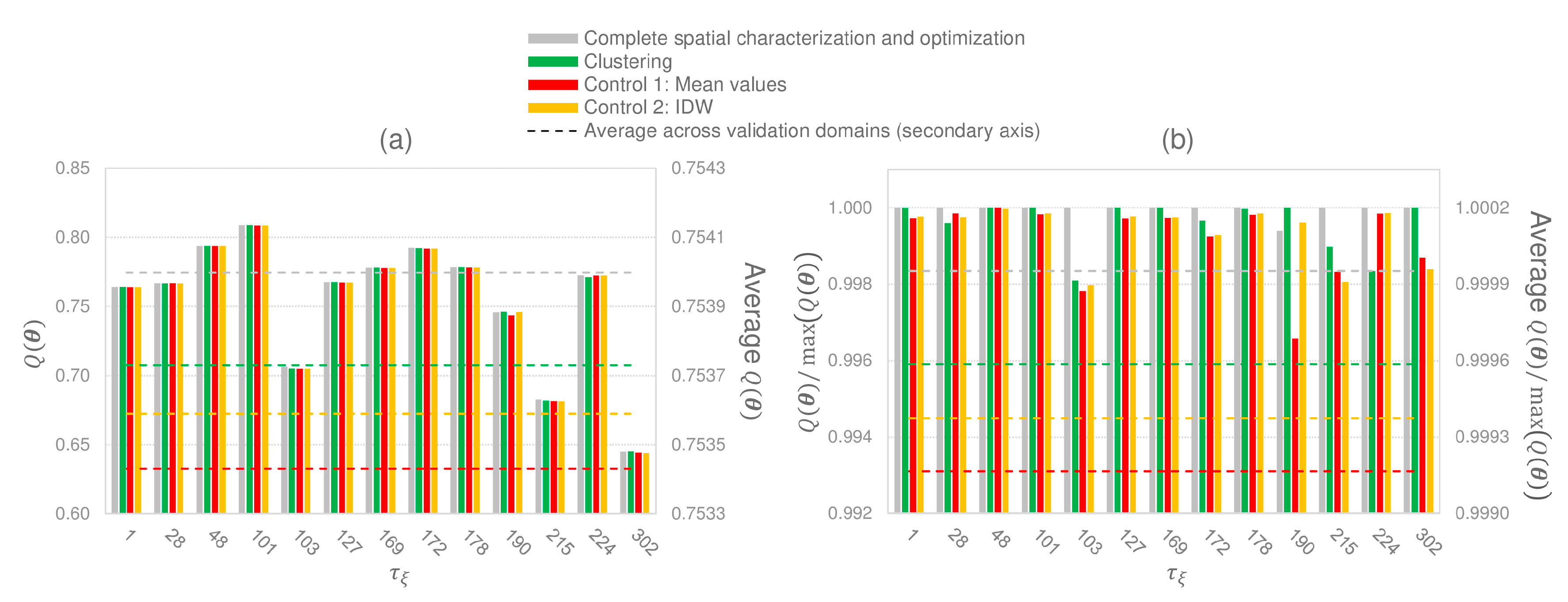
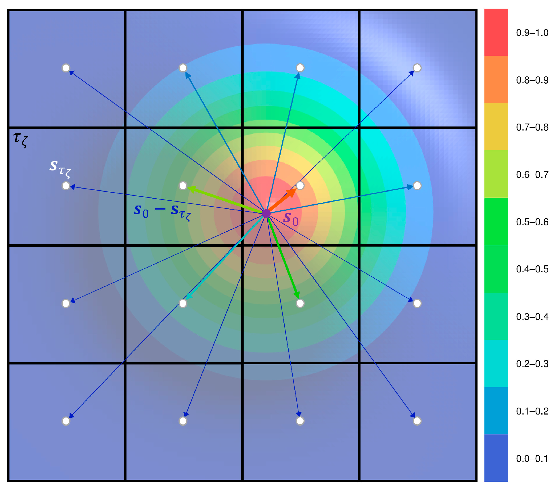
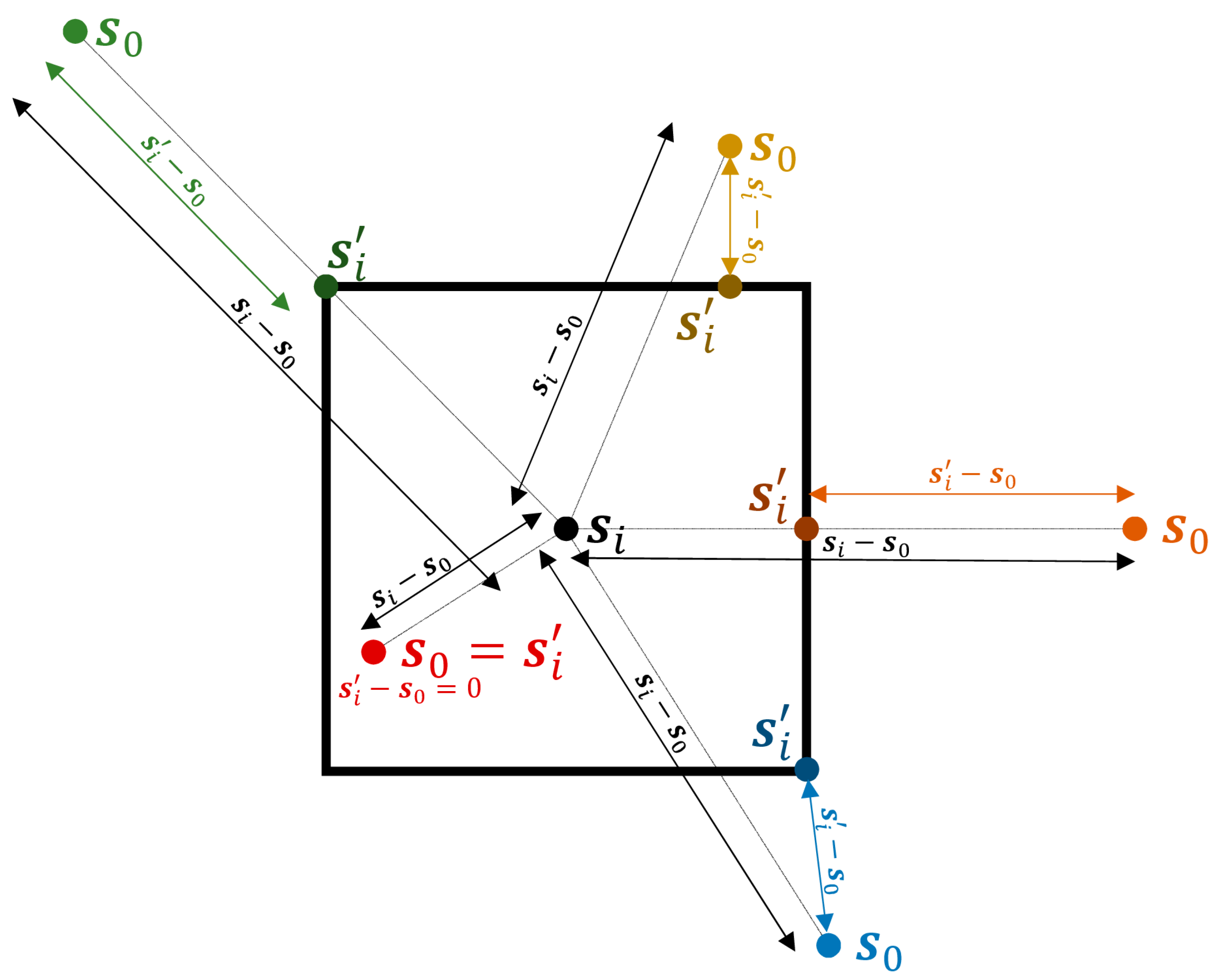
2.4.2. Simplifications in the Characterization of the Spatial and Temporal Dependences
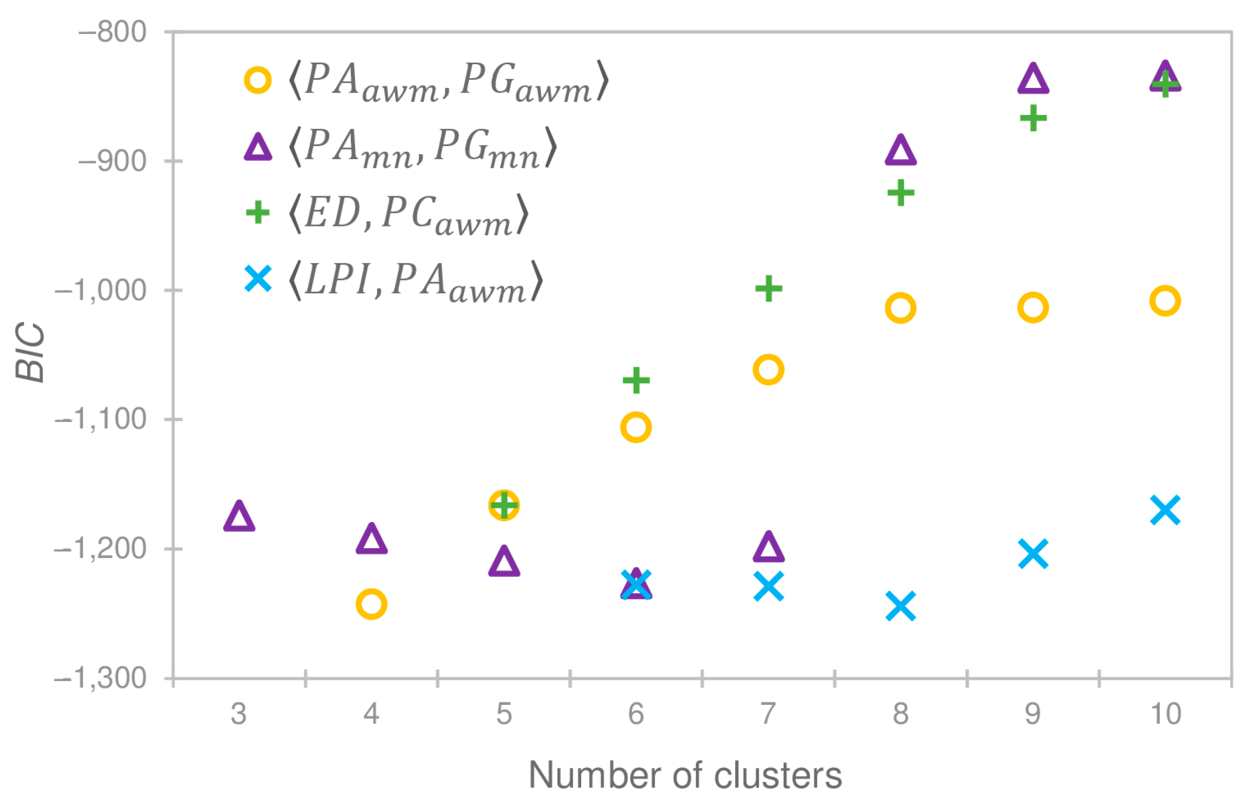
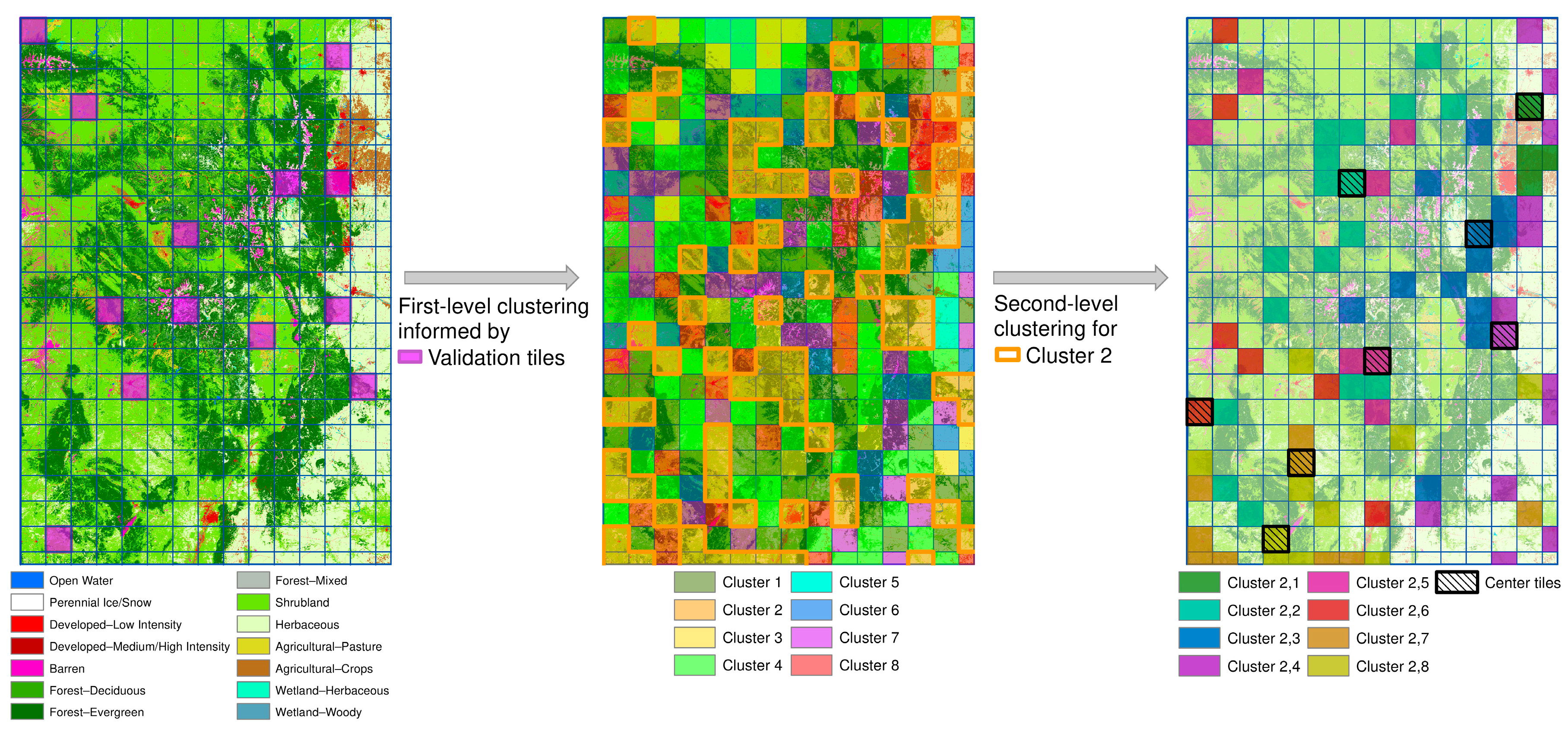
2.4.3. Domain Clustering
- Largest Patch Index (): Area of the largest patch divided by the area of the domain tile.
- Edge Density (): Ratio between the sum of the length of all patch edges and the domain tile area.
- Patch Area (): Area covered by a specific patch.
- Patch Gyrate (): Mean distance among all cells in a specific patch.
- Patch Shape (): Ratio between the perimeter of a specific patch and .
- Patch Contiguity (): Average contiguity value among all cells in a specific patch. A cell has a contiguity value of 1 if its class is the same as the class of all its adjacent cells and 0 otherwise.
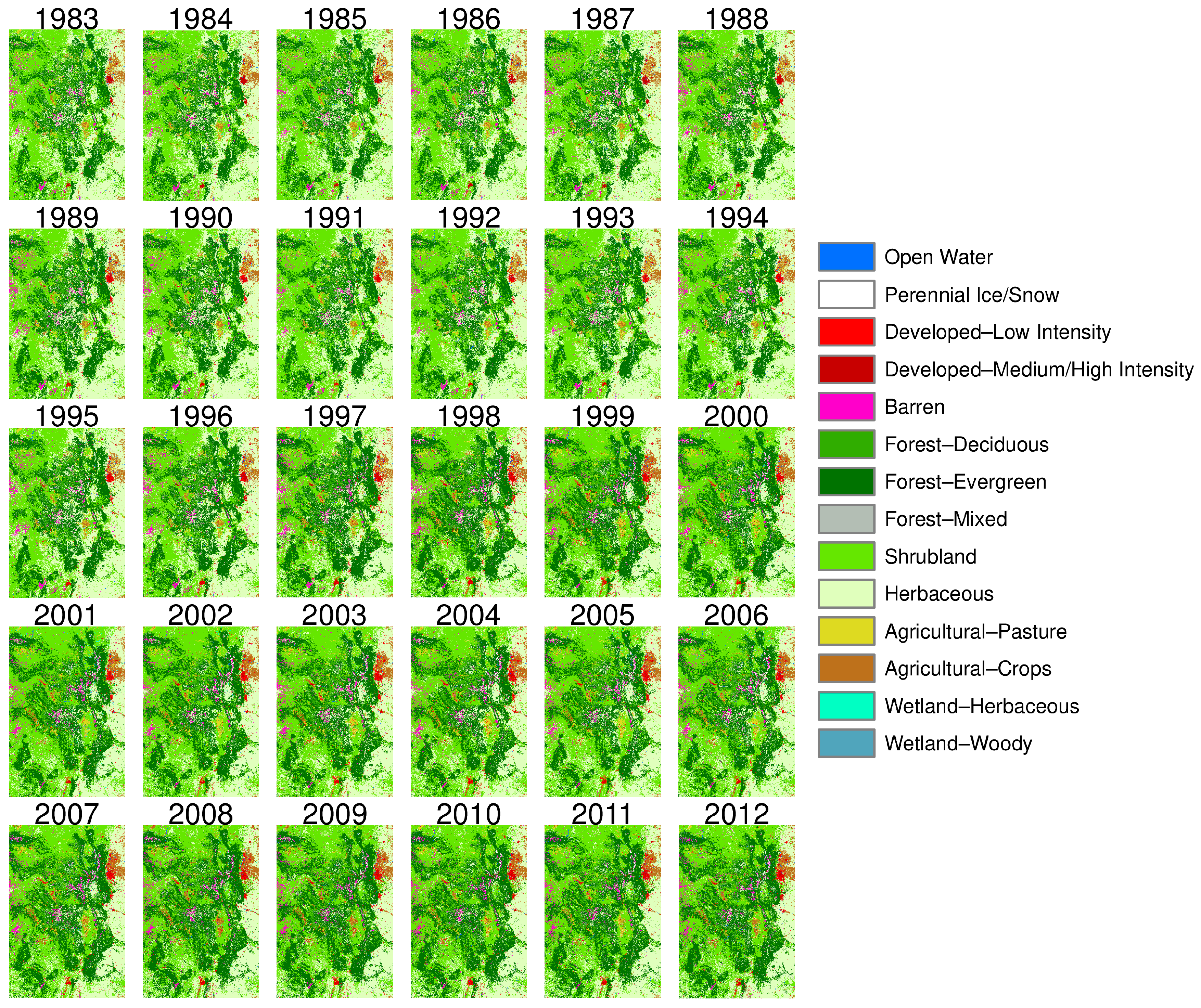
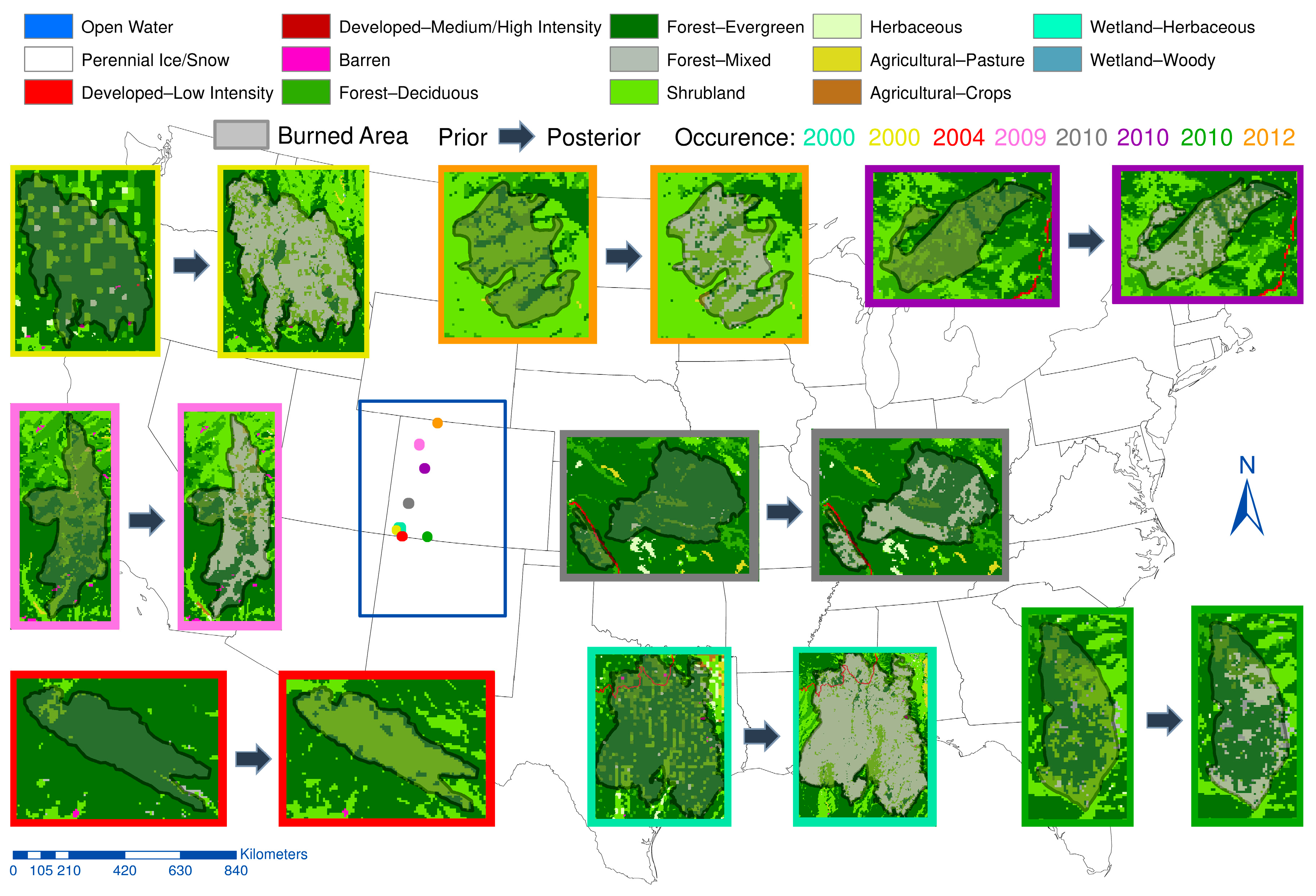
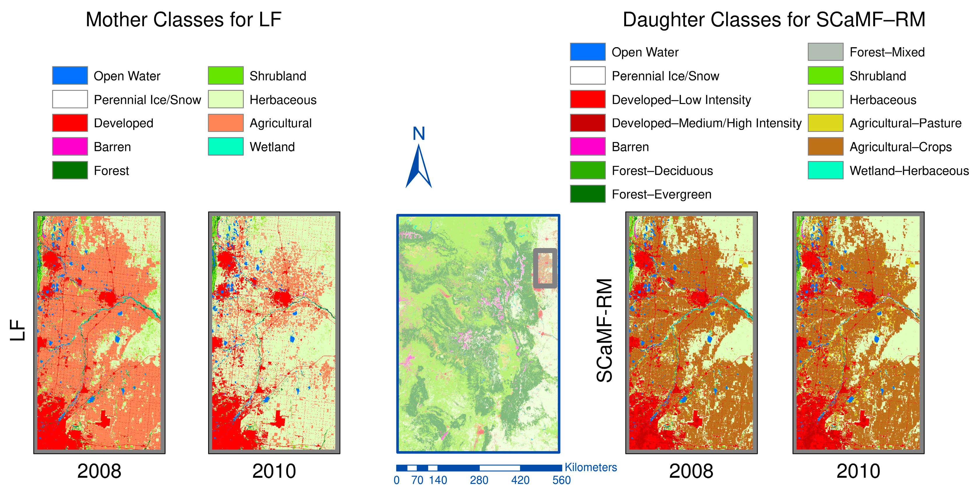
3. Results
4. Discussion
5. Conclusions
Acknowledgments
Author Contributions
Conflicts of Interest
References
- Boucher, A.; Seto, K.C.; Journel, A.G. A novel method for mapping land cover changes: Incorporating time and space with geostatistics. IEEE Trans. Geosci. Remote Sens. 2006, 44, 3427–3435. [Google Scholar] [CrossRef]
- Foody, G.M. Status of land cover classification accuracy assessment. Remote Sens. Environ. 2002, 80, 185–201. [Google Scholar] [CrossRef]
- Gao, Z.; Liu, J.; Cao, M.; Li, K.; Tao, B. Impacts of land-use and climate changes on ecosystem productivity and carbon cycle in the cropping-grazing transitional zone in China. Sci. China Ser. Earth Sci. 2005, 48, 1479–1491. [Google Scholar] [CrossRef]
- Rathjens, H.; Dörnhöfer, K.; Oppelt, N. IRSeL—An approach to enhance continuity and accuracy of remotely sensed land cover data. Int. J. Appl. Earth Obs. Geoinf. 2014, 31, 1–12. [Google Scholar] [CrossRef]
- Eva, H.; Lambin, E.F. Fires and land-cover change in the tropics: A remote sensing analysis at the landscape scale. J. Biogeogr. 2000, 27, 765–776. [Google Scholar] [CrossRef]
- Friedl, M.A.; Sulla-Menashe, D.; Tan, B.; Schneider, A.; Ramankutty, N.; Sibley, A.; Huang, X. MODIS Collection 5 global land cover: Algorithm refinements and characterization of new datasets. Remote Sens. Environ. 2010, 114, 168–182. [Google Scholar] [CrossRef]
- Fry, J.; Xian, G.; Jin, S.; Dewitz, J.; Homer, C.; Yang, L.; Barnes, C.; Herold, N.; Wickham, J. Completion of the 2006 National Land Cover Database for the conterminous United States. Photogramm. Eng. Remote Sens. 2011, 77, 858–864. [Google Scholar]
- Jin, S.; Yang, L.; Danielson, P.; Homer, C.; Fry, J.; Xian, G. A comprehensive change detection method for updating the National Land Cover Database to circa 2011. Remote Sens. Environ. 2013, 132, 159–175. [Google Scholar] [CrossRef]
- Liang, L.; Chen, Y.; Hawbaker, T.J.; Zhu, Z.; Gong, P. Mapping mountain pine beetle mortality through growth trend analysis of time-series Landsat data. Remote Sens. 2014, 6, 5696–5716. [Google Scholar] [CrossRef]
- Meddens, A.J.H.; Hicke, J.A.; Ferguson, C.A. Spatiotemporal patterns of observed bark beetle-caused tree mortality in British Columbia and the western United States. Ecol. Appl. 2012, 22, 1876–1891. [Google Scholar] [CrossRef] [PubMed]
- Jung, M.; Henkel, K.; Herold, M.; Churkina, G. Exploiting synergies of global land cover products for carbon cycle modeling. Remote Sens. Environ. 2006, 101, 534–553. [Google Scholar] [CrossRef]
- Turner, M.G. Landscape ecology: What is the state of the science? Annu. Rev. Ecol. Evol. Syst. 2005, 36, 319–344. [Google Scholar] [CrossRef]
- Calvert, K.; Luciani, P.; Mabee, W. Thematic land-cover map assimilation and synthesis: The case of locating potential bioenergy feedstock in eastern Ontario, Canada. Int. J. Geogr. Inf. Sci. 2014, 28, 274–295. [Google Scholar] [CrossRef]
- Homer, C.; Dewitz, J.A.; Yang, L.; Jin, S.; Danielson, P.; Xian, P.; Coulston, J.; Herold, N.D.; Wickham, J.D.; Megown, K. Completion of the 2011 National Land Cover Database for the conterminous United States—Representing a decade of land cover change information. Photogramm. Eng. Remote Sens. 2015, 81, 345–354. [Google Scholar]
- Petit, C.C.; Lambin, E.F. Integration of multi-source remote sensing data for land cover change detection. Int. J. Geogr. Inf. Sci. 2001, 15, 785–803. [Google Scholar] [CrossRef]
- Foody, G.M. Approaches for the production and evaluation of fuzzy land cover classifications from remotely-sensed data. Int. J. Remote Sens. 1996, 17, 1317–1340. [Google Scholar] [CrossRef]
- Latifovic, R.; Zhu, Z.-L.; Cihlar, J.; Giri, C.; Olthof, I. Land cover mapping of North and Central America—Global Land Cover 2000. Remote Sens. Environ. 2004, 89, 116–127. [Google Scholar] [CrossRef]
- Vogelmann, J.E.; Howard, S.M.; Yang, L.; Larson, C.R.; Wylie, B.K.; Van Driel, J.N. Completion of the 1990’s National Land Cover Data Set for the conterminous United States. Photogramm. Eng. Remote Sens. 2001, 67, 650–662. [Google Scholar]
- Jin, C.; Zhu, J.; Steen-Adams, M.M.; Sain, S.R.; Gangnon, R.E. Spatial multinomial regression models for nominal categorical data: A study of land cover in Northern Wisconsin, USA. Environmetrics 2013, 24, 98–108. [Google Scholar] [CrossRef]
- Burkhard, B.; Kroll, F.; Nedkov, S.; Müller, F. Mapping ecosystem service supply, demand and budgets. Ecol. Indic. 2012, 21, 17–29. [Google Scholar] [CrossRef]
- Goldstein, N.C.; Candau, J.T.; Clarke, K.C. Approaches to simulating the “March of Bricks and Mortar”. Comput. Environ. Urban Syst. 2004, 28, 125–147. [Google Scholar] [CrossRef]
- Pai, N.; Saraswat, D. SWAT2009-LUC: A tool to activate the land use change module in SWAT 2009. Trans. ASABE 2011, 54, 1649–1658. [Google Scholar] [CrossRef]
- Wentz, E.A.; Peuquet, D.J.; Anderson, S. An ensemble approach to space–time interpolation. Int. J. Geogr. Inf. Sci. 2010, 24, 1309–1325. [Google Scholar] [CrossRef]
- Johnson, E.W.; Ross, J. USDA Forest Service Rocky Mountain Region Forest Health Aerial—Survey Accuracy Assessment 2005 Report; Technical Report R2–06–08; USDA Forest Service: Lakewood, CO, USA, 2006. [Google Scholar]
- Baron, J. Rocky Mountain Futures: An Ecological Perspective; Island Press: Washington DC, United States, 2002. [Google Scholar]
- Kerr, J.T.; Ostrovsky, M. From space to species: Ecological applications for remote sensing. Trends Ecol. Evol. 2003, 18, 299–305. [Google Scholar] [CrossRef]
- Lambin, E.F. Modelling and monitoring land-cover change processes in tropical regions. Prog. Phys. Geogr. 1997, 21, 375–393. [Google Scholar] [CrossRef]
- Townshend, J.; Justice, C.; Li, W.; Gurney, C.; McManus, J. Global land cover classification by remote sensing: Present capabilities and future possibilities. Remote Sens. Environ. 1991, 35, 243–255. [Google Scholar] [CrossRef]
- Welch, R. Spatial resolution requirements for urban studies. Int. J. Remote Sens. 1982, 3, 139–146. [Google Scholar] [CrossRef]
- Foody, G.M. Harshness in image classification accuracy assessment. Int. J. Remote Sens. 2008, 29, 3137–3158. [Google Scholar] [CrossRef]
- Wilkinson, G.G. Results and implications of a study of fifteen years of satellite image classification experiments. IEEE Trans. Geosci. Remote Sens. 2005, 43, 433–440. [Google Scholar] [CrossRef]
- Congalton, R.G.; Green, K. Assessing the Accuracy of Remotely Sensed Data: Principles and Practices; CRC Press: Boca Raton, FL, USA, 2002. [Google Scholar]
- Pontius, R.G.; Millones, M. Death to Kappa: Birth of quantity disagreement and allocation disagreement for accuracy assessment. Int. J. Remote Sens. 2011, 32, 4407–4429. [Google Scholar] [CrossRef]
- Trodd, N.M. Uncertainty in land cover mapping for modelling land cover change. In Proceedings of the 21st Annual Conference of the Remote Sensing Society (RSS95-Remote Sensing in Action), Nottingham, England, 11–14 September 1995. [Google Scholar]
- Meer, F.V. der Remote-sensing image analysis and geostatistics. Int. J. Remote Sens. 2012, 33, 5644–5676. [Google Scholar] [CrossRef]
- Rodríguez-Jeangros, N.; Hering, A.S.; Kaiser, T.; McCray, J. Fusing multiple existing space-time land cover products. Environmetrics 2017. [Google Scholar] [CrossRef]
- Allard, D.; D’Or, D.; Froidevaux, R. An efficient maximum entropy approach for categorical variable prediction. Eur. J. Soil Sci. 2011, 62, 381–393. [Google Scholar] [CrossRef]
- Berrett, C.; Calder, C.A. Bayesian spatial binary classification. Spat. Stat. 2016, 16, 72–102. [Google Scholar] [CrossRef]
- Cao, G.; Kyriakidis, P.; Goodchild, M. A geostatistical framework for categorical spatial data modeling. SIGSPATIAL Spec. 2011, 3, 4–9. [Google Scholar] [CrossRef]
- Carle, S.F.; Fogg, G.E. Transition probability-based indicator geostatistics. Math. Geol. 1996, 28, 453–476. [Google Scholar] [CrossRef]
- Li, W. Markov chain random fields for estimation of categorical variables. Math. Geol. 2007, 39, 321–335. [Google Scholar] [CrossRef]
- Li, W.; Zhang, C. Application of transiograms to Markov chain simulation and spatial uncertainty assessment of land-cover classes. GISci. Remote Sens. 2005, 42, 297–319. [Google Scholar] [CrossRef]
- Viviroli, D.; Dürr, H.H.; Messerli, B.; Meybeck, M.; Weingartner, R. Mountains of the world, water towers for humanity: Typology, mapping, and global significance. Water Resour. Res. 2007, 43, W07447. [Google Scholar] [CrossRef]
- Hauer, F.R.; Baron, J.S.; Campbell, D.H.; Fausch, K.D.; Hostetler, S.W.; Leavesley, G.H.; Leavitt, P.R.; Mcknight, D.M.; Stanford, J.A. Assessment of climate change and freshwater ecosystems of the Rocky Mountains, USA and Canada. Hydrol. Process. 1997, 11, 903–924. [Google Scholar] [CrossRef]
- Carey, E.V.; Sala, A.; Keane, R.; Callaway, R.M. Are old forests underestimated as global carbon sinks? Glob. Chang. Biol. 2001, 7, 339–344. [Google Scholar] [CrossRef]
- Hansen, E.M.; Amacher, M.C.; Van Miegroet, H.; Long, J.N.; Ryan, M.G. Carbon dynamics in central US rockies lodgepole pine type after mountain pine beetle outbreaks. For. Sci. 2015. [Google Scholar] [CrossRef]
- Mikkelson, K.M.; Bearup, L.A.; Maxwell, R.M.; Stednick, J.D.; McCray, J.E.; Sharp, J.O. Bark beetle infestation impacts on nutrient cycling, water quality and interdependent hydrological effects. Biogeochemistry 2013, 115, 1–21. [Google Scholar] [CrossRef]
- Hess, C.T.; Michel, J.; Horton, T.R.; Prichard, H.M.; Coniglio, W.A. The occurrence of radioactivity in public water supplies in the United States. Health Phys. 1985, 48, 553–586. [Google Scholar] [CrossRef] [PubMed]
- Jirak, I.L.; Cotton, W.R. Effect of air pollution on precipitation along the front range of the Rocky Mountains. J. Appl. Meteorol. Climatol. 2006, 45, 236–245. [Google Scholar] [CrossRef]
- Pec, G.J.; Karst, J.; Sywenky, A.N.; Cigan, P.W.; Erbilgin, N.; Simard, S.W.; Cahill, J.F. Rapid increases in forest understory diversity and productivity following a mountain pine beetle (dendroctonus ponderosae) outbreak in pine forests. PLOS ONE 2015, 10, e0124691. [Google Scholar] [CrossRef] [PubMed]
- Veblen, T.T.; Lorenz, D.C. Anthropogenic disturbance and recovery patterns in montane forests, Colorado front range. Phys. Geogr. 1986, 7, 1–24. [Google Scholar] [CrossRef]
- Loveland, T.R.; Reed, B.C.; Brown, J.F.; Ohlen, D.O.; Zhu, Z.; Yang, L.; Merchant, J.W. Development of a global land cover characteristics database and IGBP DISCover from 1 km AVHRR data. Int. J. Remote Sens. 2000, 21, 28. [Google Scholar] [CrossRef]
- Bartholomé, E.; Belward, A.S. GLC2000: A new approach to global land cover mapping from Earth observation data. Int. J. Remote Sens. 2005, 26, 1959–1977. [Google Scholar] [CrossRef]
- Anderson, J.R.; Hardy, E.E.; Roach, J.T.; Witmer, R.E. A Land Use and Land Cover Classification System for Use With Remote Sensor Data; Professional Paper; United States Department of The Interior: Alexandria, VA, USA, 1976. [Google Scholar]
- Homer, C.; Dewitz, J.; Fry, J.; Coan, M.; Hossain, N.; Larson, C.; Herold, N.; McKerrow, A.; VanDriel, J.N.; Wickham, J. Completion of the 2001 National Land Cover Database for the conterminous United States. Photogramm. Eng. Remote Sens. 2007, 73, 337–341. [Google Scholar]
- Friedl, M.A.; McIver, D.K.; Hodges, J.C.F.; Zhang, X.Y.; Muchoney, D.; Strahler, A.H.; Woodcock, C.E.; Gopal, S.; Schneider, A.; Cooper, A.; et al. Global land cover mapping from MODIS: Algorithms and early results. Remote Sens. Environ. 2002, 83, 287–302. [Google Scholar] [CrossRef]
- Price, C.V.; Nakagaki, N.; Hitt, K.J.; Clawges, R.M. Enhanced Historical Land-Use and Land-Cover Data Sets of the U.S. Geological Survey; U.S. Geological Survey Data Series; U.S. Department of the Interior, U.S. Geological Survey: Reston, VA, USA, 2007.
- Price, C.V.; Nakagaki, N.; Hitt, K.J.; Clawges, R.M. Mining GIRAS: Improving on a national treasure of land use data. In Proceedings of the ESRI International User Conference, Redlands, CA, USA, 7–11 July 2003. [Google Scholar]
- Sohl, T.L. Spatially explicit land-use and land-cover scenarios for the Great Plains of the United States. Agric. Ecosyst. Environ. 2012, 153, 1–15. [Google Scholar] [CrossRef]
- Sohl, T.L.; Sayler, K.L.; Drummond, M.A.; Loveland, T.R. The FORE-SCE model: A practical approach for projecting land cover change using scenario-based modeling. J. Land Use Sci. 2007, 2, 103–126. [Google Scholar] [CrossRef]
- Sohl, T.L.; Claggett, P.R. Clarity versus complexity: Land-use modeling as a practical tool for decision-makers. J. Environ. Manag. 2013, 129, 235–243. [Google Scholar] [CrossRef] [PubMed]
- USGS, Earth Resources Observation and Science (EROS) Center. Conterminous United States Projected Land-Use/Land-Cover Mosaics 1938–1992; USGS, EROS: Sioux Falls, SD, USA, 2015.
- USGS, Earth Resources Observation and Science (EROS) Center. LandCarbon Conterminous United States Land-Use/Land-Cover Mosaics 1992–2100; USGS, EROS: Sioux Falls, SD, USA, 2013.
- Wildland Fire Science, Earth Resources Observation and Science Center. LANDFIRE Existing Vegetation Cover; USGS, EROS: Sioux Falls, SD, USA, 2010.
- Wickham, J.D.; Stehman, S.V.; Fry, J.A.; Smith, J.H.; Homer, C.G. Thematic accuracy of the NLCD 2001 land cover for the conterminous United States. Remote Sens. Environ. 2010, 114, 1286–1296. [Google Scholar] [CrossRef]
- Wickham, J.D.; Stehman, S.V.; Gass, L.; Dewitz, J.; Fry, J.A.; Wade, T.G. Accuracy assessment of NLCD 2006 land cover and impervious surface. Remote Sens. Environ. 2013, 130, 294–304. [Google Scholar] [CrossRef]
- National Center for Atmospheric Research—NCAR. Computational and Information Systems Laboratory; Boulder, CO, USA, 2012. Available online: http://n2t.net/ark:/85065/d7wd3xhc (accessed on 1 July 2016–1 April 2017).
- GDAL. Development Team GDAL—Geospatial Data Abstraction Library: Version 2.0.1, 2017.
- McGarigal, K.; Cushman, S.A.; Ene, E. FRAGSTATS v4: Spatial Pattern Analysis Program for Categorical and Continuous Maps; University of Massachusetts: Amherst, MA, USA, 2012. [Google Scholar]
- Fraley, C.; Raftery, A.E.; Murphy, T.B.; Scrucca, L. mclust Version 4 for R: Normal Mixture Modeling for Model-Based Clustering, Classification, and Density Estimation; Department of Statistics, University of Washington: Seattle, WA, USA, 2012. [Google Scholar]
- Fraley, C.; Raftery, A.E. Model-based clustering, discriminant analysis, and density estimation. J. Am. Stat. Assoc. 2002, 97, 611–631. [Google Scholar] [CrossRef]
- Johnson, R.A.; Wichern, D.W. Clustering Based on Statistical Models. In Applied Multivariate Statistical Analysis; Pearson Prentice Hall: Upper Saddle River, NJ, USA, 2007; pp. 703–706. [Google Scholar]
- MacQueen, J. Some methods for classification and analysis of multivariate observations. In Proceedings of the Fifth Berkeley Symposium on Mathematical Statistics and Probability; University of California Press: Berkeley, CA, USA, 1967; Volume 1, pp. 281–297. [Google Scholar]
- Friedman, H.P.; Rubin, J. On some invariant criteria for grouping data. J. Am. Stat. Assoc. 1967, 62, 1159–1178. [Google Scholar] [CrossRef]
- Wilks, S.S. Certain generalizations in the analysis of variance. Biometrika 1932, 24, 471–494. [Google Scholar] [CrossRef]
- Digital Collections of Colorado. Available online: http://dspace.colostate.edu/ (accessed on 5 March 2017).
- Cayan, D.R.; Dettinger, M.D.; Diaz, H.F.; Graham, N.E. Decadal variability of precipitation over Western North America. J. Clim. 1998, 11, 3148–3166. [Google Scholar] [CrossRef]
- Ross, T.; Lott, N.; McCown, S.; Quinn, D. The El Niño Winter of ′97-′98; National Climatic Data Center; National Oceanic and Atmospheric Administration: Asheville, NC, USA, 1998.
- Schoennagel, T.; Veblen, T.T.; Romme, W.H. The interaction of fire, fuels, and climate across rocky mountain forests. BioScience 2004, 54, 661–676. [Google Scholar] [CrossRef]
- Golubiewski, N.E. Urbanization increases grassland carbon pools: Effects of landscaping in Colorado’s front range. Ecol. Appl. 2006, 16, 555–571. [Google Scholar] [CrossRef]
- Manfredo, M.J.; Zinn, H.C. Population change and its implications for wildlife management in the New West: A case study of Colorado. Hum. Dimens. Wildl. 1996, 1, 62–74. [Google Scholar] [CrossRef]
- Pepin, N.; Losleben, M. Climate change in the Colorado Rocky Mountains: Free air versus surface temperature trends. Int. J. Climatol. 2002, 22, 311–329. [Google Scholar] [CrossRef]
- Riebsame, W.E.; Gosnell, H.; Theobald, D.M. Land use and landscape change in the Colorado Mountains I: Theory, scale, and pattern. Mt. Res. Dev. 1996, 16, 395–405. [Google Scholar] [CrossRef]
- Smutny, G. Legislative support for growth management in the Rocky Mountains: An exploration of attitudes in Idaho. J. Am. Plann. Assoc. 1998, 64, 311–323. [Google Scholar] [CrossRef]
- Adams, H.D.; Luce, C.H.; Breshears, D.D.; Allen, C.D.; Weiler, M.; Hale, V.C.; Smith, A.M.S.; Huxman, T.E. Ecohydrological consequences of drought- and infestation- triggered tree die-off: Insights and hypotheses. Ecohydrology 2012, 5, 145–159. [Google Scholar] [CrossRef]
- Collins, B.J.; Rhoades, C.C.; Hubbard, R.M.; Battaglia, M.A. Tree regeneration and future stand development after bark beetle infestation and harvesting in Colorado lodgepole pine stands. For. Ecol. Manag. 2011, 261, 2168–2175. [Google Scholar] [CrossRef]
- Jonášová, M.; Matějková, I. Natural regeneration and vegetation changes in wet spruce forests after natural and artificial disturbances. Can. J. For. Res. 2007, 37, 1907–1914. [Google Scholar] [CrossRef]
- Jonášová, M.; Prach, K. The influence of bark beetles outbreak vs. salvage logging on ground layer vegetation in Central European mountain spruce forests. Biol. Conserv. 2008, 141, 1525–1535. [Google Scholar] [CrossRef]
- Kayes, L.J.; Tinker, D.B. Forest structure and regeneration following a mountain pine beetle epidemic in southeastern Wyoming. For. Ecol. Manag. 2012, 263, 57–66. [Google Scholar] [CrossRef]
- Meigs, G.W.; Kennedy, R.E.; Cohen, W.B. A Landsat time series approach to characterize bark beetle and defoliator impacts on tree mortality and surface fuels in conifer forests. Remote Sens. Environ. 2011, 115, 3707–3718. [Google Scholar] [CrossRef]
- Raffa, K.F.; Aukema, B.H.; Bentz, B.J.; Carroll, A.L.; Hicke, J.A.; Turner, M.G.; Romme, W.H. Cross-scale drivers of natural disturbances prone to anthropogenic amplification: The dynamics of bark beetle eruptions. BioScience 2008, 58, 501–517. [Google Scholar] [CrossRef]
- Eidenshink, J.C.; Schwind, B.; Brewer, K.; Zhu, Z.-L.; Quayle, B.; Howard, S.M. A project for monitoring trends in burn severity. Fire Ecol. 2007, 3, 321. [Google Scholar] [CrossRef]
- Finko, M.; Quayle, B.; Zhang, Y.; Lecker, J.; Megown, K.A.; Brewer, C.K. Monitoring Trends and Burn Severity (MTBS): Monitoring Wildfire Activity for the Past Quarter Century Using Landsat Data. In Proceedings of the Moving from Status To Trends: Forest Inventory and Analysis (FIA) Symposium, Baltimore, MD, USA, 4–6 December 2012; pp. 222–228. [Google Scholar]
- Gong, P.; Howarth, P.J. The use of structural information for improving land-cover classification accuracies at the rural-urban fringe. Photogramm. Eng. Remote Sens. 1990, 56, 67–73. [Google Scholar]
- Lunetta, R.S.; Ilames, J.; Knight, J.; Congalton, R.G.; Mace, T.H. An assessment of reference data variability using a Virtual Field Reference Database. Photogramm. Eng. Remote Sens. 2001, 67, 707–715. [Google Scholar]
- Graff, C.G.; Sidky, E.Y. Compressive sensing in medical imaging. Appl. Opt. 2015, 54, C23–C44. [Google Scholar] [CrossRef] [PubMed]
- Hill, D.L.; Batchelor, P.G.; Holden, M.; Hawkes, D.J. Medical image registration. Phys. Med. Biol. 2001, 46, R1–45. [Google Scholar] [CrossRef] [PubMed]
- Wald, L. Data Fusion: Definitions and Architectures: Fusion of Images of Different Spatial Resolutions; Presses des MINES: Paris, France, 2002. [Google Scholar]


| Ranges | Parameter | Domain | ||||
|---|---|---|---|---|---|---|
| 1 | 2 | 3 | 4 | |||
| (a) | Prediction: mother ranges Agreement: mother ranges | αmax | 0.002 | 0.002 | 0.002 | 0.002 |
| αslope | 1 | 1 | 10 | 500 | ||
| β | 2 | 2 | 2 | 2 | ||
| Q(θ) | 0.7640 | 0.7287 | 0.7803 | 0.8326 | ||
| (b) | Prediction: daughter ranges Agreement: mother ranges | αmax | 0.002 | 0.002 | 0.002 | 0.002 |
| αslope | 1 | 1 | 1 | 500 | ||
| β | 2 | 0.7 | 2 | 2 | ||
| Q(θ) | 0.7641 | 0.7294 | 0.7803 | 0.8325 | ||
| (a) | Prediction: mother ranges Agreement: daughter ranges | αmax | 0.002 | 0.002 | 0.002 | 0.002 |
| αslope | 1 | 1 | 1 | 500 | ||
| β | 2 | 0.7 | 1.7 | 2 | ||
| Q(θ) | 0.7629 | 0.7648 | 0.7775 | 0.8320 | ||
| (b) | Prediction: daughter ranges Agreement: daughter ranges | αmax | 0.002 | 0.002 | 0.002 | 0.002 |
| αslope | 1 | 1 | 1 | 500 | ||
| β | 2 | 0.7 | 2 | 2 | ||
| Q(θ) | 0.7630 | 0.7642 | 0.7777 | 0.8320 | ||
| Feature Combination () | Number of Clusters () | Percentile |
|---|---|---|
| 8 | 76.87% | |
| 9 | 31.46% | |
| 10 | 74.59% | |
| 10 | 52.00% |
© 2017 by the authors. Licensee MDPI, Basel, Switzerland. This article is an open access article distributed under the terms and conditions of the Creative Commons Attribution (CC BY) license (http://creativecommons.org/licenses/by/4.0/).
Share and Cite
Rodríguez-Jeangros, N.; Hering, A.S.; Kaiser, T.; McCray, J.E. SCaMF–RM: A Fused High-Resolution Land Cover Product of the Rocky Mountains. Remote Sens. 2017, 9, 1015. https://doi.org/10.3390/rs9101015
Rodríguez-Jeangros N, Hering AS, Kaiser T, McCray JE. SCaMF–RM: A Fused High-Resolution Land Cover Product of the Rocky Mountains. Remote Sensing. 2017; 9(10):1015. https://doi.org/10.3390/rs9101015
Chicago/Turabian StyleRodríguez-Jeangros, Nicolás, Amanda S. Hering, Timothy Kaiser, and John E. McCray. 2017. "SCaMF–RM: A Fused High-Resolution Land Cover Product of the Rocky Mountains" Remote Sensing 9, no. 10: 1015. https://doi.org/10.3390/rs9101015
APA StyleRodríguez-Jeangros, N., Hering, A. S., Kaiser, T., & McCray, J. E. (2017). SCaMF–RM: A Fused High-Resolution Land Cover Product of the Rocky Mountains. Remote Sensing, 9(10), 1015. https://doi.org/10.3390/rs9101015