Subpixel Inundation Mapping Using Landsat-8 OLI and UAV Data for a Wetland Region on the Zoige Plateau, China


Abstract
:1. Introduction
2. Materials and Methods
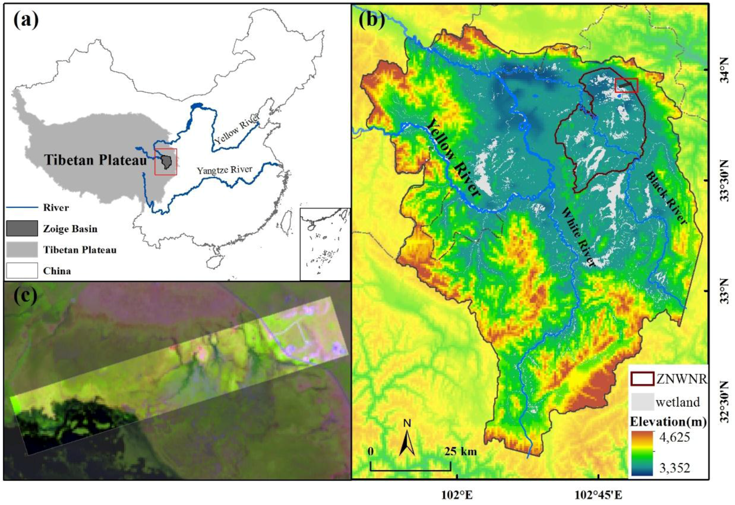
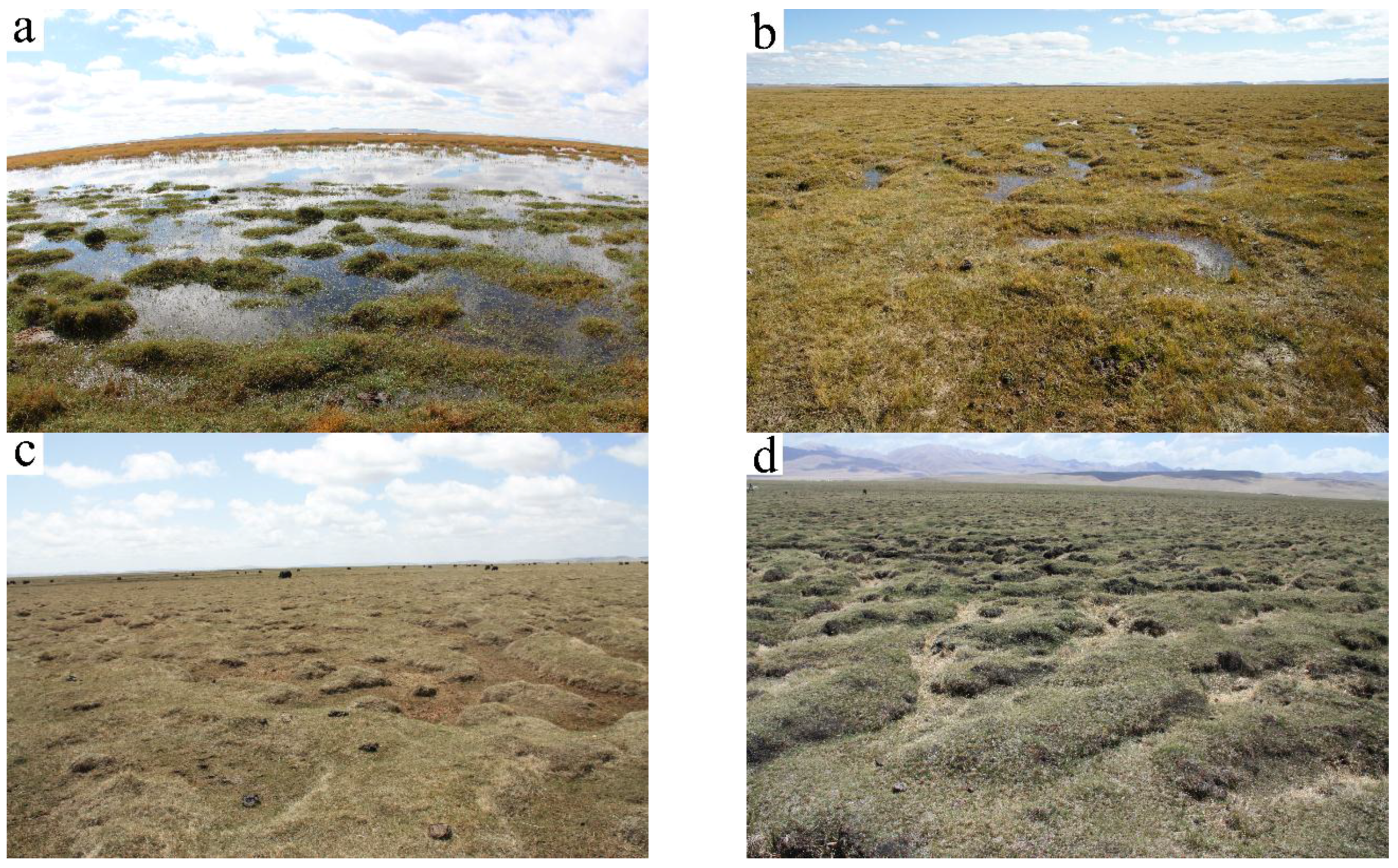
2.1. Study Area
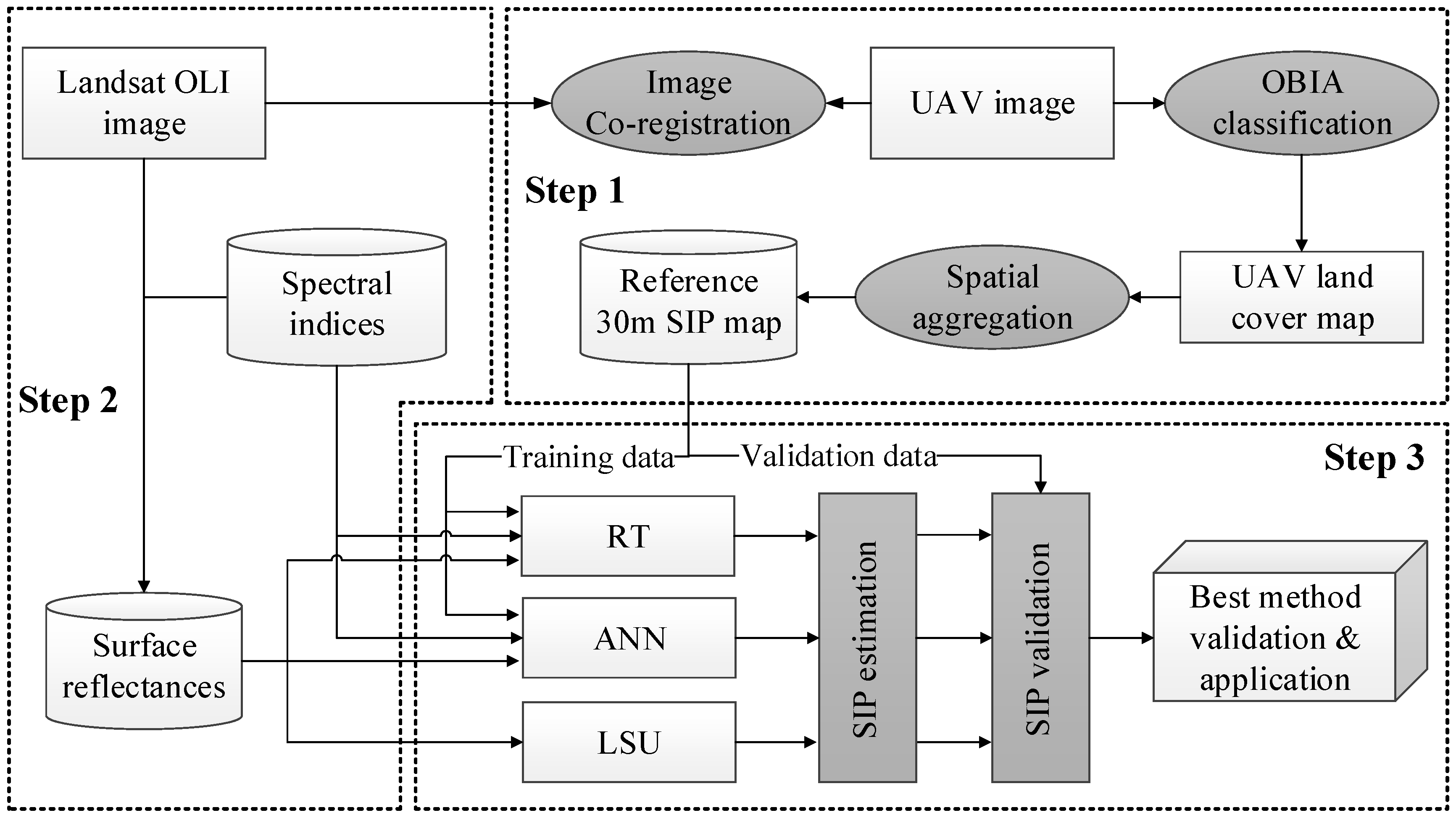
2.2. Overview of the Approaches
2.3. Deriving the Reference SIP from the UAV Data
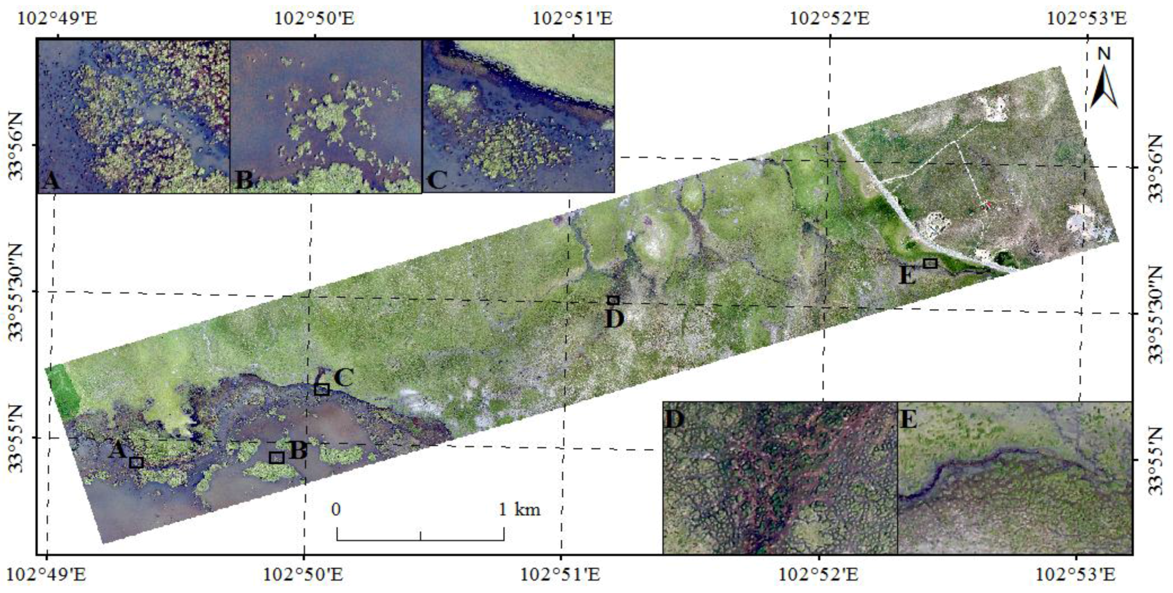
2.3.1. UAV Data
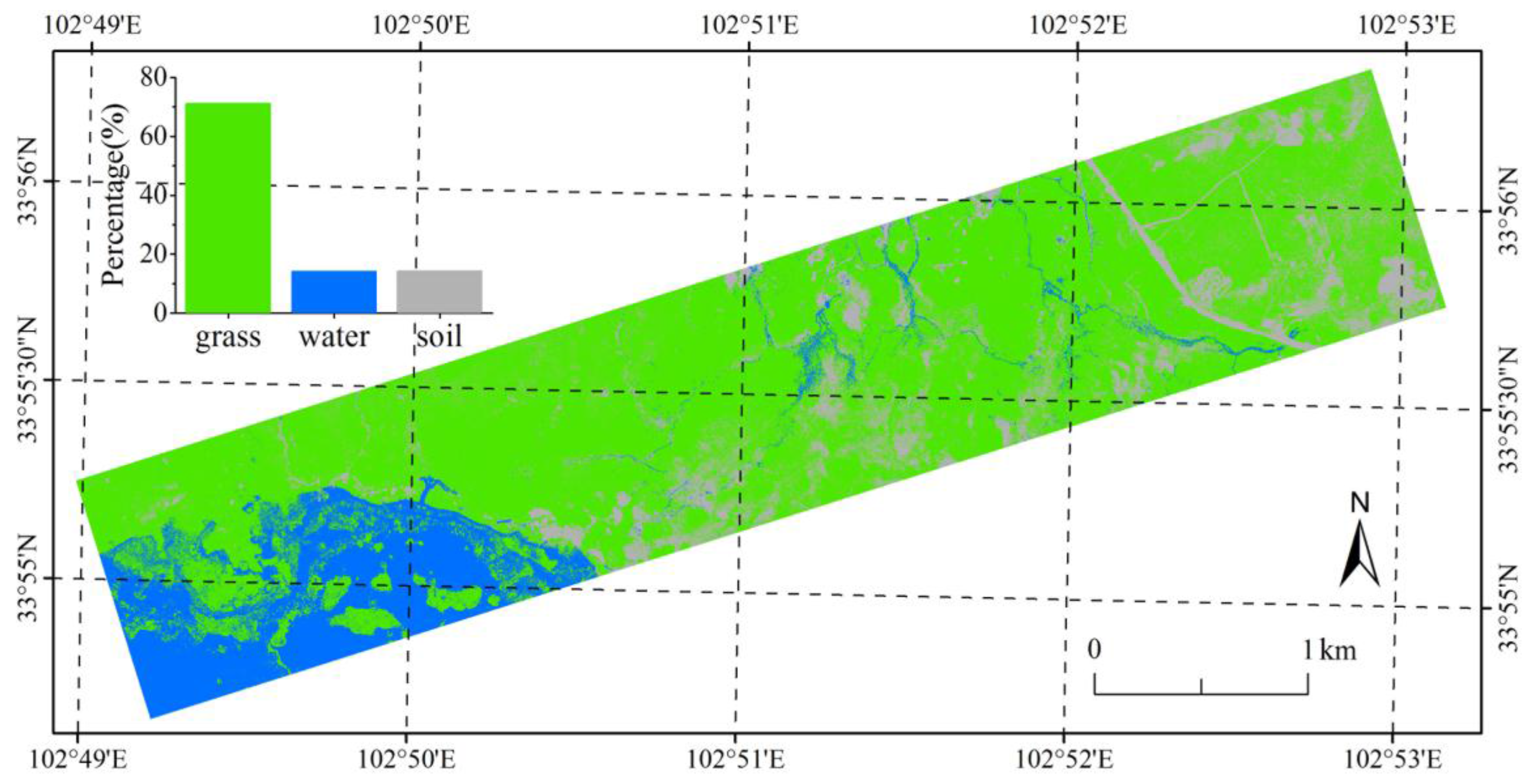
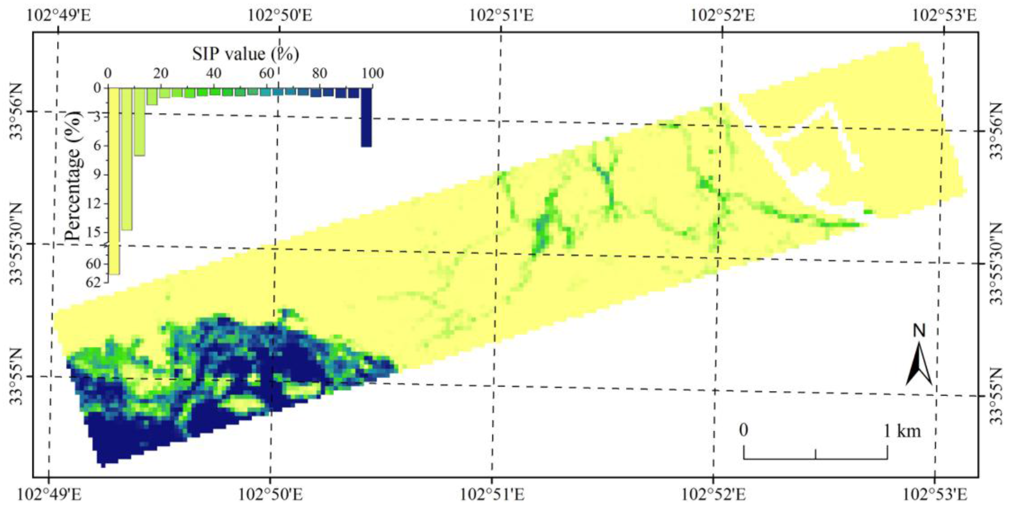
2.3.2. Reference SIP Extraction from the UAV Data
2.4. SIP Modeling
2.4.1. Landsat-8 OLI Data
2.4.2. Variables Derived from Landsat Data
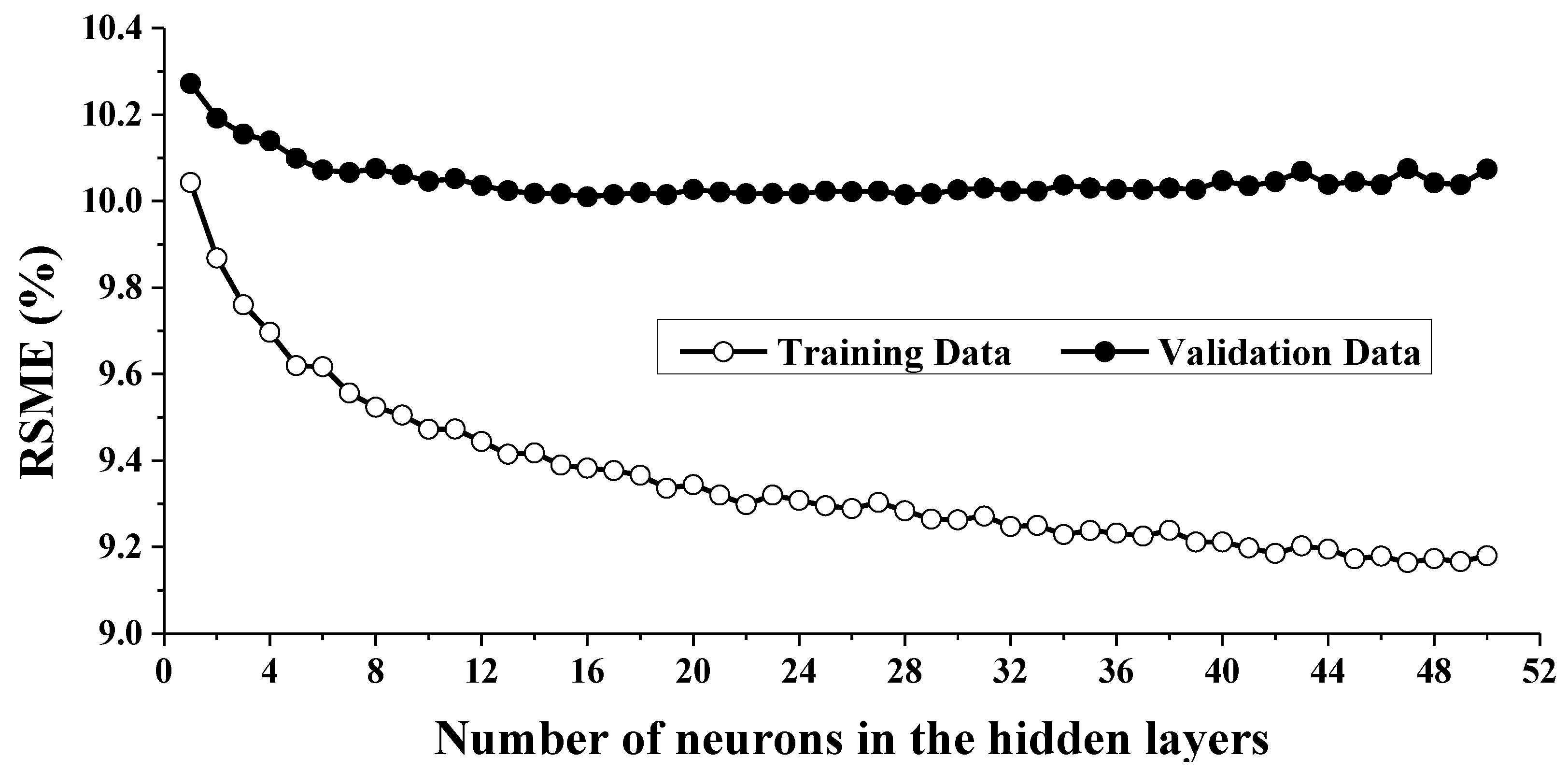
2.4.3. Modeling Approaches
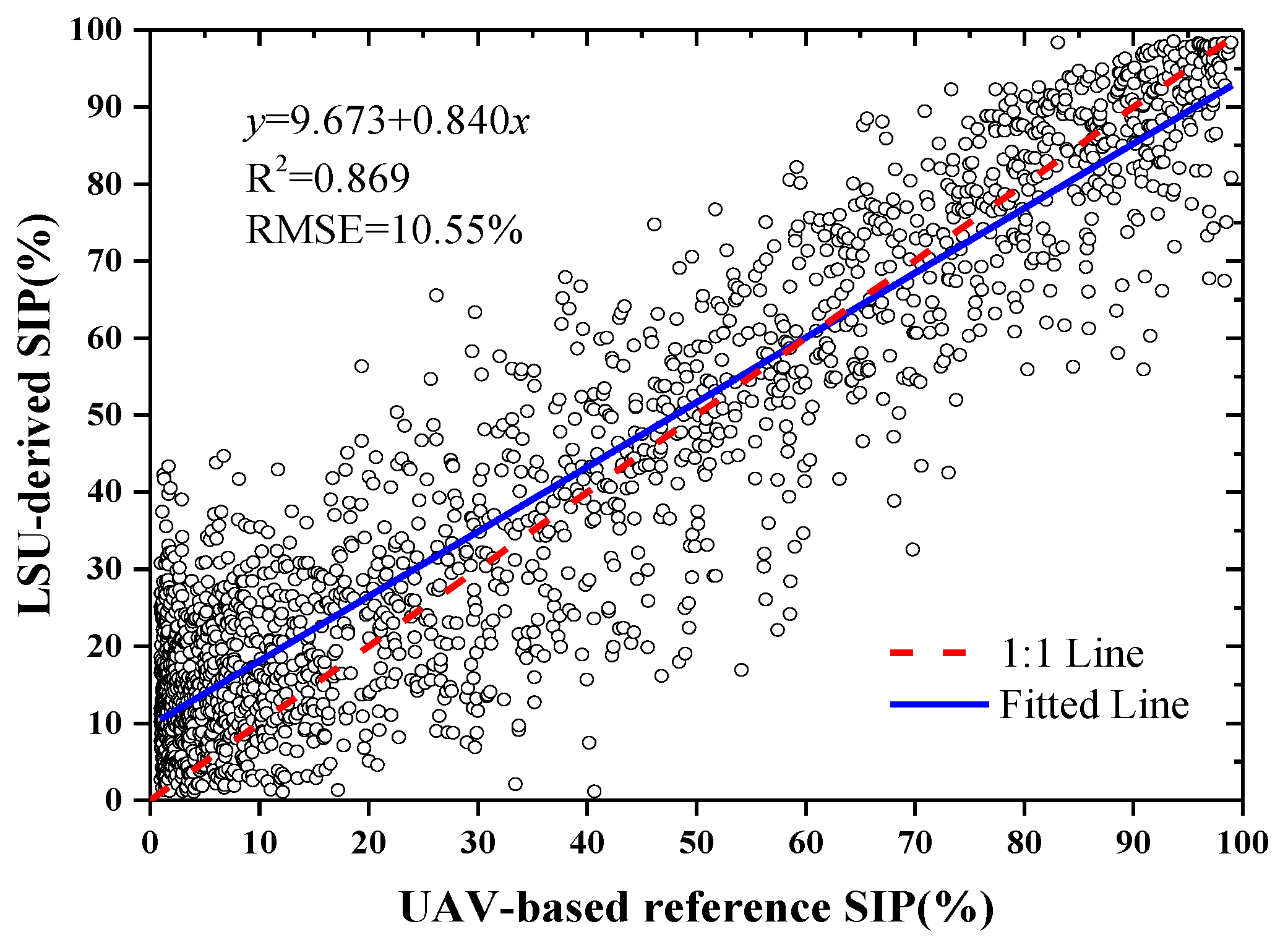
(1) LSU method
(2) ANN method
(3) RT method
2.4.4. Evaluation Metrics
3. Results
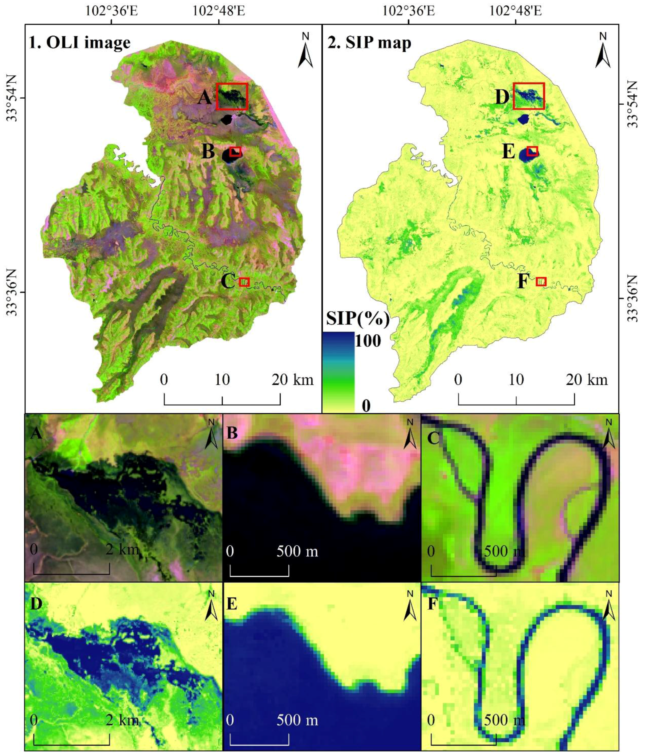
3.1. Reference SIP
3.2. Correlation Analysis between the Reference SIP and the Landsat-8 OLI Spectral Data
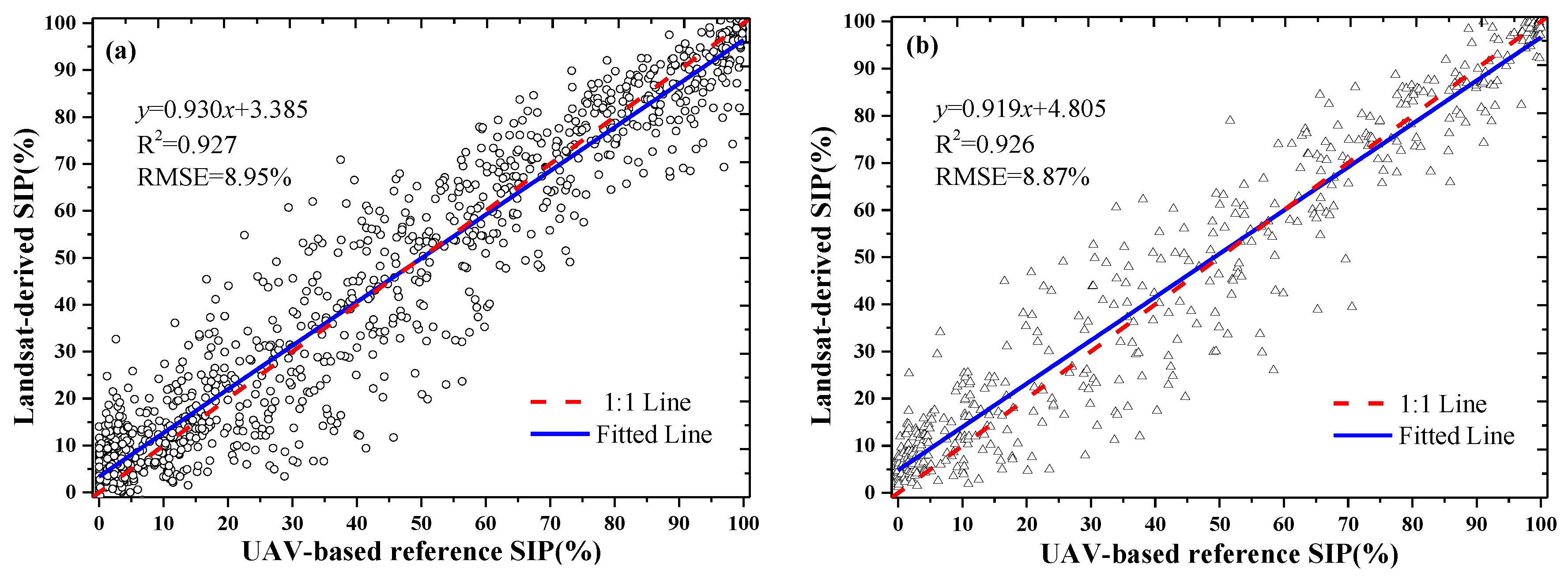
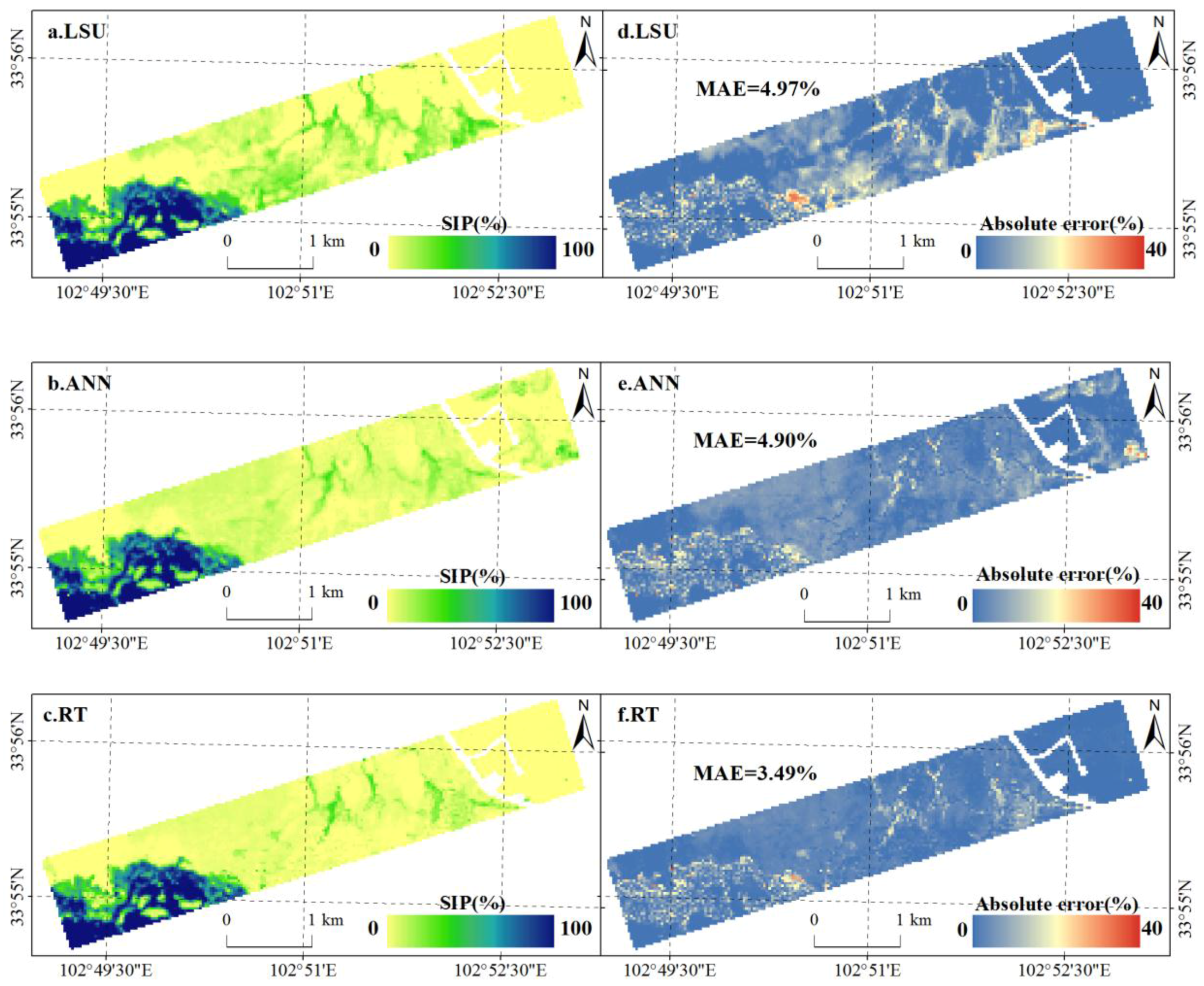
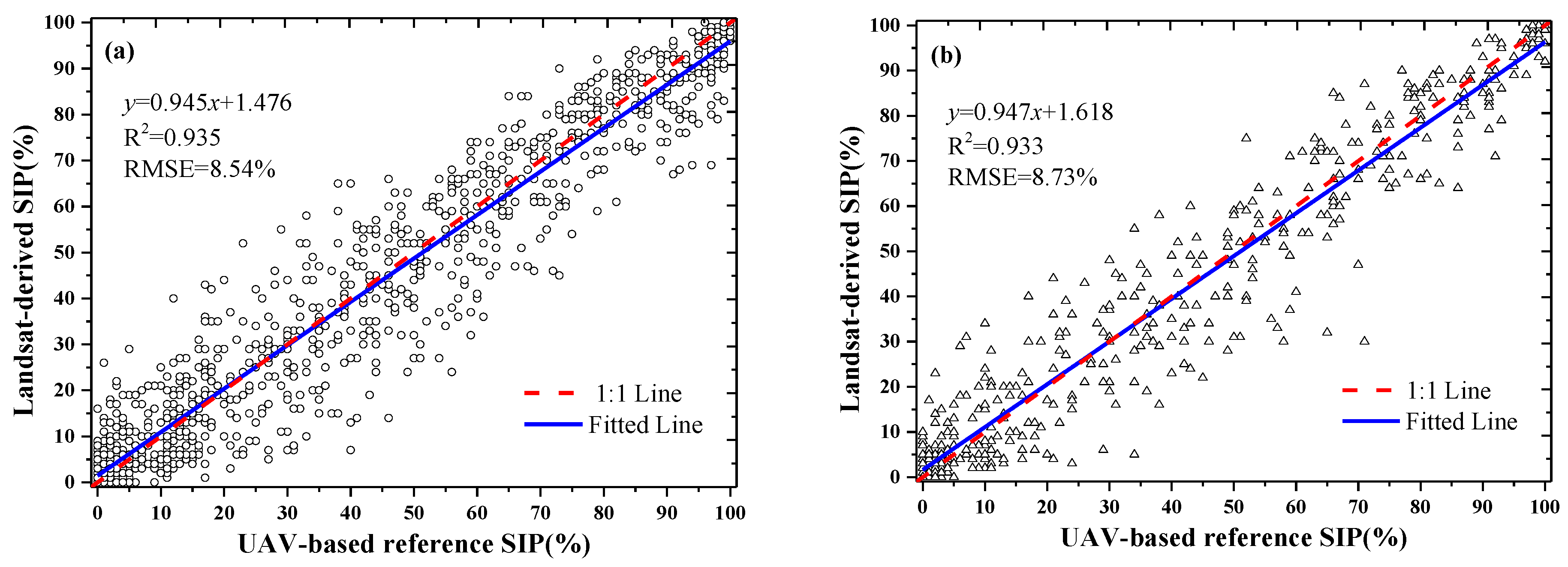
3.3. Performance of LSU, ANN, and RT Methods
3.3.1. SIP Estimation with LSU Method
3.3.2. SIP estimation with ANN and RT Method
(1) ANN performance
(2) RT performance
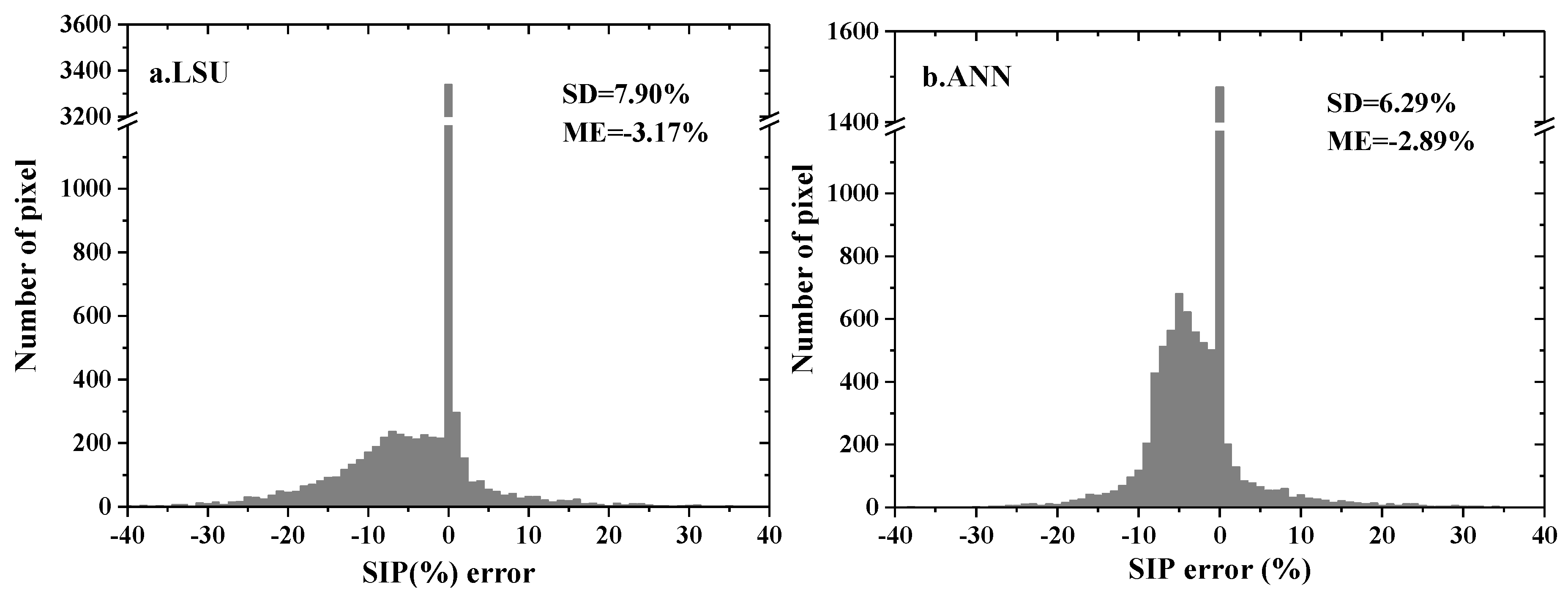
3.4. Spatial Pattern of the SIP Estimation Error Using LSU, ANN, and RT Methods
4. Discussion
4.1. Comparison of the Performance of the Three Methods
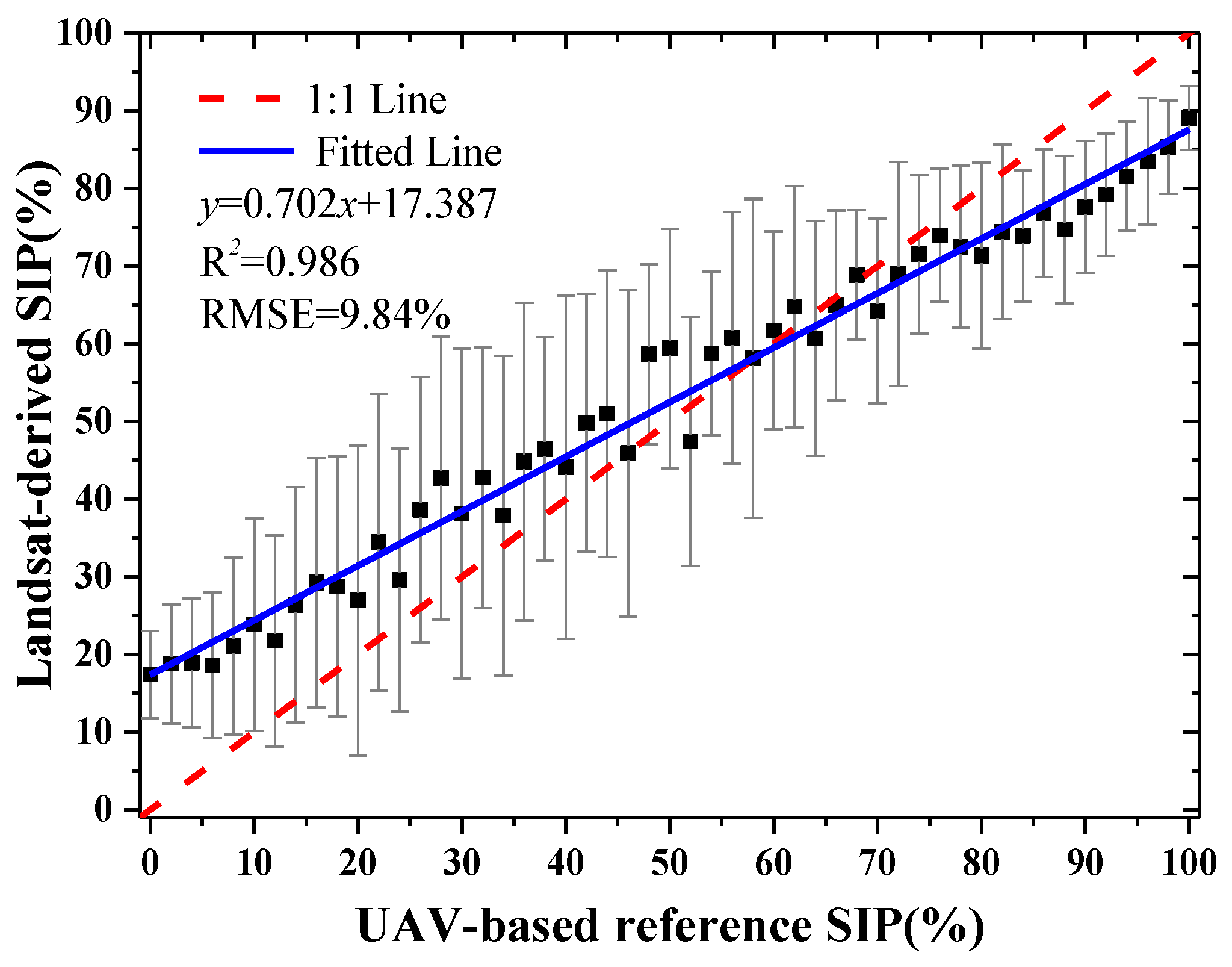
4.2. Validation of the Best Prediction Model in 2013
4.3. Application in the Zoige Wetland National Nature Reserve
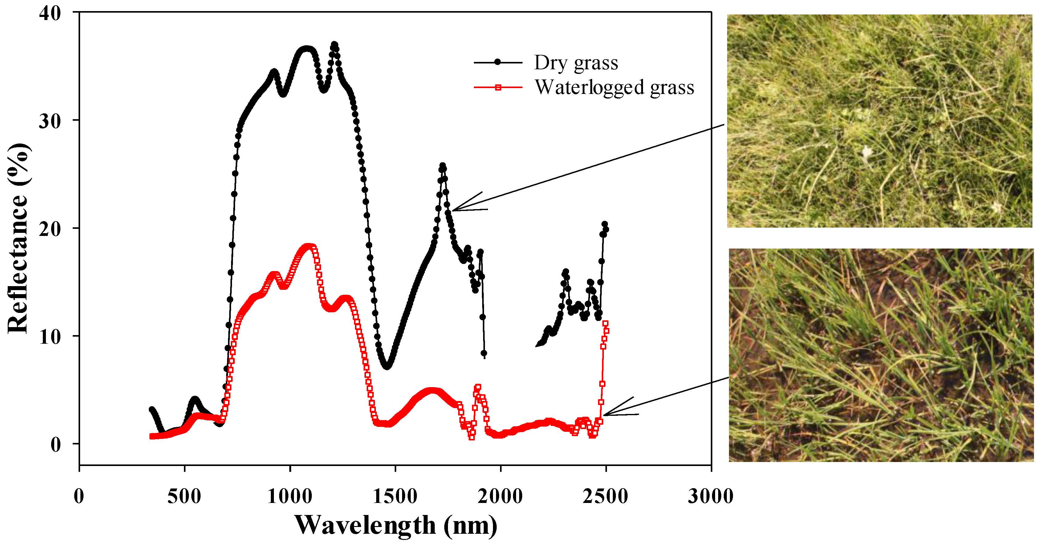
4.4. Uncertainty Analysis
(1) Spectral uncertainty of the UAV data
(2) Uncertainty of geolocation matching between the UAV and satellite image
5. Conclusions
Acknowledgments
Author Contributions
Conflicts of Interest
References
- Houlahan, J.E.; Keddy, P.A.; Makkay, K.; Findlay, C.S. The effects of adjacent land use on wetland species richness and community composition. Wetlands 2006, 26, 79–96. [Google Scholar] [CrossRef]
- Li, A.N.; Deng, W.; Kong, B.; Lu, X.N.; Feng, W.L.; Lei, G.B.; Bai, J.H. A study on wetland landscape pattern and its change process in Huang-Huai-Hai (3H) Area, China. J. Environ. Inf. 2013, 21, 23–34. [Google Scholar] [CrossRef]
- Kang, X.M.; Hao, Y.B.; Cui, X.C.; Chen, H.; Huang, S.X.; Du, Y.G.; Li, W.; Kardol, P.; Xiao, X.M.; Cui, L.J. Variability and changes in climate, phenology, and gross primary production of an alpine wetland ecosystem. Remote Sens. 2016, 8. [Google Scholar] [CrossRef]
- Nestler, J.M.; Long, K.S. Development of hydrological indices to aid cumulative impact analysis of riverine wetlands. Regul. River 1997, 13, 317–334. [Google Scholar] [CrossRef]
- Huang, C.Q.; Peng, Y.; Lang, M.; Yeo, I.-Y.; McCarty, G. Wetland inundation mapping and change monitoring using Landsat and airborne LiDAR data. Remote Sens. Environ. 2014, 141, 231–242. [Google Scholar] [CrossRef]
- Baker, C.; Lawrence, R.; Montagne, C.; Patten, D. Mapping wetlands and riparian areas using Landsat ETM+ imagery and decision-tree-based models. Wetlands 2006, 26, 465–474. [Google Scholar] [CrossRef]
- Whiteside, T.G.; Bartolo, R.E. Use of WorldView-2 time series to establish a wetland monitoring program for potential offsite impacts of mine site rehabilitation. Int. J. App. Earth Obs. 2015, 42, 24–37. [Google Scholar] [CrossRef]
- Prigent, C.; Matthews, E.; Aires, F.; Rossow, W.B. Remote sensing of global wetland dynamics with multiple satellite data sets. Geophys. Res. Lett. 2001, 28, 4631–4634. [Google Scholar] [CrossRef]
- Gallant, A. The challenges of remote monitoring of wetlands. Remote Sens. 2015, 7, 10938–10950. [Google Scholar] [CrossRef]
- Zhang, L.P.; Wu, K.; Zhong, Y.F.; Li, P.X. A new sub-pixel mapping algorithm based on a BP neural network with an observation model. Neurocomputing 2008, 71, 2046–2054. [Google Scholar] [CrossRef]
- Halabisky, M.; Moskal, L.M.; Gillespie, A.; Hannam, M. Reconstructing semi-arid wetland surface water dynamics through spectral mixture analysis of a time series of Landsat satellite images (1984–2011). Remote Sens. Environ. 2016, 177, 171–183. [Google Scholar] [CrossRef]
- Shimabukuro, Y.E.; Smith, J. The least-squares mixing models to generate fraction images derived from remote sensing multispectral data. IEEE Trans. Geosci. Remote Sens. 1991, 29, 16–20. [Google Scholar] [CrossRef]
- Huang, C.Q.; Townshend, J.R.G. A stepwise regression tree for nonlinear approximation: Applications to estimating subpixel land cover. Int. J. Remote Sens. 2003, 24, 75–90. [Google Scholar] [CrossRef]
- Kimes, D.S.; Nelson, R.F.; Manry, M.T.; Fung, A.K. Attributes of neural networks for extracting continuous vegetation variables from optical and radar measurements. Int. J. Remote Sens. 1998, 19, 2639–2663. [Google Scholar] [CrossRef]
- Alcântara, E.; Barbosa, C.; Stech, J.; Novo, E.; Shimabukuro, Y. Improving the spectral unmixing algorithm to map water turbidity distributions. Environ. Model. Softw. 2009, 24, 1051–1061. [Google Scholar] [CrossRef]
- Asner, G.P.; Heidebrecht, K.B. Spectral unmixing of vegetation, soil and dry carbon cover in arid regions: Comparing multispectral and hyperspectral observations. Int. J. Remote Sens. 2002, 23, 3939–3958. [Google Scholar] [CrossRef]
- Meyer, T.; Okin, G.S. Evaluation of spectral unmixing techniques using MODIS in a structurally complex savanna environment for retrieval of green vegetation, nonphotosynthetic vegetation, and soil fractional cover. Remote Sens. Environ. 2015, 161, 122–130. [Google Scholar] [CrossRef]
- Cross, A.M.; Settle, J.J.; Drake, N.A.; Paivinen, R.T.M. Subpixel measurement of tropical forest cover using AVHRR data. Int. J. Remote Sens. 1991, 12, 1119–1129. [Google Scholar] [CrossRef]
- Roberts, D.A.; Smith, M.O.; Adams, J.B. Green vegetation, nonphotosynthetic vegetation, and soils in AVIRIS data. Remote Sens. Environ. 1993, 44, 255–269. [Google Scholar] [CrossRef]
- Atkinson, P.M. Downscaling in remote sensing. Int. J. App. Earth Obs. 2013, 22, 106–114. [Google Scholar] [CrossRef]
- Li, A.N.; Liang, S.L.; Wang, A.S.; Qin, J. Estimating crop yield from multi-temporal satellite data using multivariate regression and neural network techniques. Photogramm. Eng. Remote Sens. 2007, 73, 1149–1157. [Google Scholar] [CrossRef]
- Mertens, K.C.; Verbeke, L.P.; Westra, T.; Wulf, R.R.D. Sub-pixel mapping and sub-pixel sharpening using neural network predicted wavelet coefficients. Remote Sens. Environ. 2004, 91, 225–236. [Google Scholar] [CrossRef]
- Weng, Q.H.; Hu, X.F. Medium spatial resolution satellite imagery for estimating and mapping urban impervious surfaces using LSMA and ANN. IEEE Trans. Geosci. Remote Sens. 2008, 46, 2397–2406. [Google Scholar] [CrossRef]
- Ozesmi, S.L.; Bauer, M.E. Satellite remote sensing of wetlands. Wetl. Ecol. Manag. 2002, 10, 381–402. [Google Scholar] [CrossRef]
- Rango, A.; Laliberte, A.; Steele, C.; Herrick, J.E.; Bestelmeyer, B.; Schmugge, T.; Roanhorse, A.; Jenkins, V. Using unmanned aerial vehicles for rangelands: Current applications and future potentials. Environ. Pract. 2006, 8, 159–168. [Google Scholar] [CrossRef]
- Li, A.N.; Bian, J.H.; Lei, G.B.; Huang, C.Q. Estimating the maximal light use efficiency for different vegetation through the CASA Model combined with time-series remote sensing data and ground measurements. Remote Sens. 2012, 4, 3857–3876. [Google Scholar] [CrossRef]
- Qiu, P.F.; Wu, N.; Luo, P.; Wang, Z.Y.; Li, M.H. Analysis of dynamics and driving factors of wetland landscape in Zoige, eastern Qinghai-Tibetan plateau. J. Mt. Sci. 2009, 6, 42–55. [Google Scholar] [CrossRef]
- Xia, H.M.; Li, A.N.; Zhao, W.; Jin, H.A.; Lei, G.B.; Bian, J.H.; Tan, J.B. Spatio-temporal variation and driving forces in alpine grassland phenology in the Zoigê Plateau from 2001–2013. In Proceedings of the 2014 IEEE International Geoscience and Remote Sensing Symposium (IGARSS 2014), Quebec, QC, Canada, 13–18 July 2014; pp. 2181–2184.
- Laliberte, A.S.; Rango, A.; Havstad, K.M.; Paris, J.F.; Beck, R.F.; McNeely, R.; Gonzalez, A.L. Object-oriented image analysis for mapping shrub encroachment from 1937 to 2003 in southern New Mexico. Remote Sens. Environ. 2004, 93, 198–210. [Google Scholar] [CrossRef]
- Ma, L.; Cheng, L.; Li, M.C.; Liu, Y.X.; Ma, X.X. Training set size, scale, and features in Geographic Object-Based Image Analysis of very high resolution unmanned aerial vehicle imagery. ISPRS J. Photogramm. Remote Sens. 2015, 102, 14–27. [Google Scholar] [CrossRef]
- USGS National Center for Earth Resources Observation and Science Center (EROS). Available online: https://espa.cr.usgs.gov/ (accessed on 5 July 2015).
- Storey, J.; Choate, M.; Lee, K. Landsat 8 Operational Land Imager on-orbit geometric calibration and performance. Remote Sens. 2014, 6, 11127–11152. [Google Scholar] [CrossRef]
- Tucker, C.J. Red and photographic infrared linear combinations for monitoring vegetation. Remote Sens. Environ. 1979, 8, 127–150. [Google Scholar] [CrossRef]
- Huete, A.R.; Liu, H.Q.; Batchily, K.B.; Leeuwen, W.V. A comparison of vegetation indices over a global set of TM images for EOS-MODIS. Remote Sens. Environ. 1997, 59, 440–451. [Google Scholar] [CrossRef]
- Gao, B.C. NDWI—A normalized difference water index for remote sensing of vegetation liquid water from space. Remote Sens. Environ. 1996, 58, 257–266. [Google Scholar] [CrossRef]
- Rogers, A.S.; Kearney, M.S. Reducing signature variability in unmixing coastal marsh Thematic Mapper scenes using spectral indices. Int. J. Remote Sens. 2004, 25, 2317–2335. [Google Scholar] [CrossRef]
- McFeeters, S.K. The use of the Normalized Difference Water Index (NDWI) in the delineation of open water features. Int. J. Remote Sens. 1996, 17, 1425–1432. [Google Scholar] [CrossRef]
- Xu, H.Q. Modification of normalised difference water index (NDWI) to enhance open water features in remotely sensed imagery. Int. J. Remote Sens. 2006, 27, 3025–3033. [Google Scholar] [CrossRef]
- Sohn, Y.; McCoy, R.M. Mapping desert shrub rangeland using spectral unmixing and modeling spectral mixtures with TM data. Photogramm. Eng. Remote Sens. 1997, 63, 707–716. [Google Scholar]
- Atkinson, P.M.; Tatnall, A.R.L. Introduction neural networks in remote sensing. Int. J. Remote Sens. 1997, 18, 699–709. [Google Scholar] [CrossRef]
- Yang, L.M.; Huang, C.Q.; Homer, C.G.; Wylie, B.K.; Coan, M.J. An approach for mapping large-area impervious surfaces: Synergistic use of Landsat-7 ETM+ and high spatial resolution imagery. Can. J. Remote Sens. 2003, 29, 230–240. [Google Scholar] [CrossRef]
- Li, A.N.; Huang, C.Q.; Sun, G.Q.; Shi, H.; Toney, C.; Zhu, Z.L.; Rollins, M.G.; Goward, S.N.; Masek, J.G. Modeling the height of young forests regenerating from recent disturbances in Mississippi using Landsat and ICESat data. Remote Sens. Environ. 2011, 115, 1837–1849. [Google Scholar] [CrossRef]
- RuleQuest. Available online: http://www.rulequest.com (accessed on 18 July 2014).
- Wylie, B.K.; Fosnight, E.A.; Gilmanov, T.G.; Frank, A.B.; Morgan, J.A.; Haferkamp, M.R.; Meyers, T.P. Adaptive data-driven models for estimating carbon fluxes in the Northern Great Plains. Remote Sens. Environ. 2007, 106, 399–413. [Google Scholar] [CrossRef]
- Xiao, J.F.; Zhuang, Q.L.; Law, B.E.; Chen, J.Q.; Baldocchi, D.D.; Cook, D.R.; Oren, R.; Richardson, A.D.; Wharton, S.; Ma, S. A continuous measure of gross primary production for the conterminous United States derived from MODIS and AmeriFlux data. Remote Sens. Environ. 2010, 114, 576–591. [Google Scholar] [CrossRef]


| Spectral Index | Definition | Reference |
|---|---|---|
| NDVI | (band 5 – band 4)/(band 5 + band 4) | Tucker [33] |
| EVI | 2.5 × (band 5 – band 4)/(band 5 + 6 × band 4 − 7.5 × band 2 + 1) | Huete et al. [34] |
| NDWI_1 | (band 5 – band 6)/(band 5 + band 6) | Gao [35] |
| NDWI_2 | (band 4 – band 6)/(band 4 + band 6) | Rogers and Kearney [36] |
| NDWI_3 | (band 3 – band 5)/(band 3 + band 5) | McFeeters [37] |
| MNDWI | (band 3 – band 6)/(band 3 + band 6) | Xu [38] |
| Reference | Classified | Total | Producer’s Accuracy (%) | ||
|---|---|---|---|---|---|
| Grass | Water | Soil | |||
| Grass | 104 | 3 | 4 | 111 | 93.69 |
| Water | 2 | 66 | 1 | 69 | 95.65 |
| Soil | 3 | 2 | 51 | 56 | 91.07 |
| Total | 109 | 71 | 56 | 236 | |
| User’s accuracy (%) | 95.41 | 92.96 | 91.07 | ||
| Overall accuracy: 93.64%; Kappa coefficient: 0.9 | |||||
| B1 | B2 | B3 | B4 | B5 | B6 | B7 |
| 0.40 | 0.41 | 0.59 | 0.49 | 0.74 | 0.64 | 0.60 |
| EVI | NDVI | NDWI_1 | NDWI_2 | NDWI_3 | MNDWI | |
| 0.75 | 0.48 | 0.26 | 0.67 | 0.26 | 0.68 |
© 2017 by the authors; licensee MDPI, Basel, Switzerland. This article is an open access article distributed under the terms and conditions of the Creative Commons Attribution (CC-BY) license (http://creativecommons.org/licenses/by/4.0/).
Share and Cite
Xia, H.; Zhao, W.; Li, A.; Bian, J.; Zhang, Z. Subpixel Inundation Mapping Using Landsat-8 OLI and UAV Data for a Wetland Region on the Zoige Plateau, China. Remote Sens. 2017, 9, 31. https://doi.org/10.3390/rs9010031
Xia H, Zhao W, Li A, Bian J, Zhang Z. Subpixel Inundation Mapping Using Landsat-8 OLI and UAV Data for a Wetland Region on the Zoige Plateau, China. Remote Sensing. 2017; 9(1):31. https://doi.org/10.3390/rs9010031
Chicago/Turabian StyleXia, Haoming, Wei Zhao, Ainong Li, Jinhu Bian, and Zhengjian Zhang. 2017. "Subpixel Inundation Mapping Using Landsat-8 OLI and UAV Data for a Wetland Region on the Zoige Plateau, China" Remote Sensing 9, no. 1: 31. https://doi.org/10.3390/rs9010031
APA StyleXia, H., Zhao, W., Li, A., Bian, J., & Zhang, Z. (2017). Subpixel Inundation Mapping Using Landsat-8 OLI and UAV Data for a Wetland Region on the Zoige Plateau, China. Remote Sensing, 9(1), 31. https://doi.org/10.3390/rs9010031