Do Agrometeorological Data Improve Optical Satellite-Based Estimations of the Herbaceous Yield in Sahelian Semi-Arid Ecosystems?
Abstract
:1. Introduction
- Wd: amount of water stored in the soil at the end of the dekad (d)
- Wd–1: amount of water stored in the soil at the end of the previous dekad (d–1)
- R: cumulated rainfall during the dekad
- ETm: maximum evapotranspiration in the decadal period
- r: represents the water losses due to runoff in the decadal period
- i: represents the water losses due to deep percolation in the decadal period
2. Materials and Methods
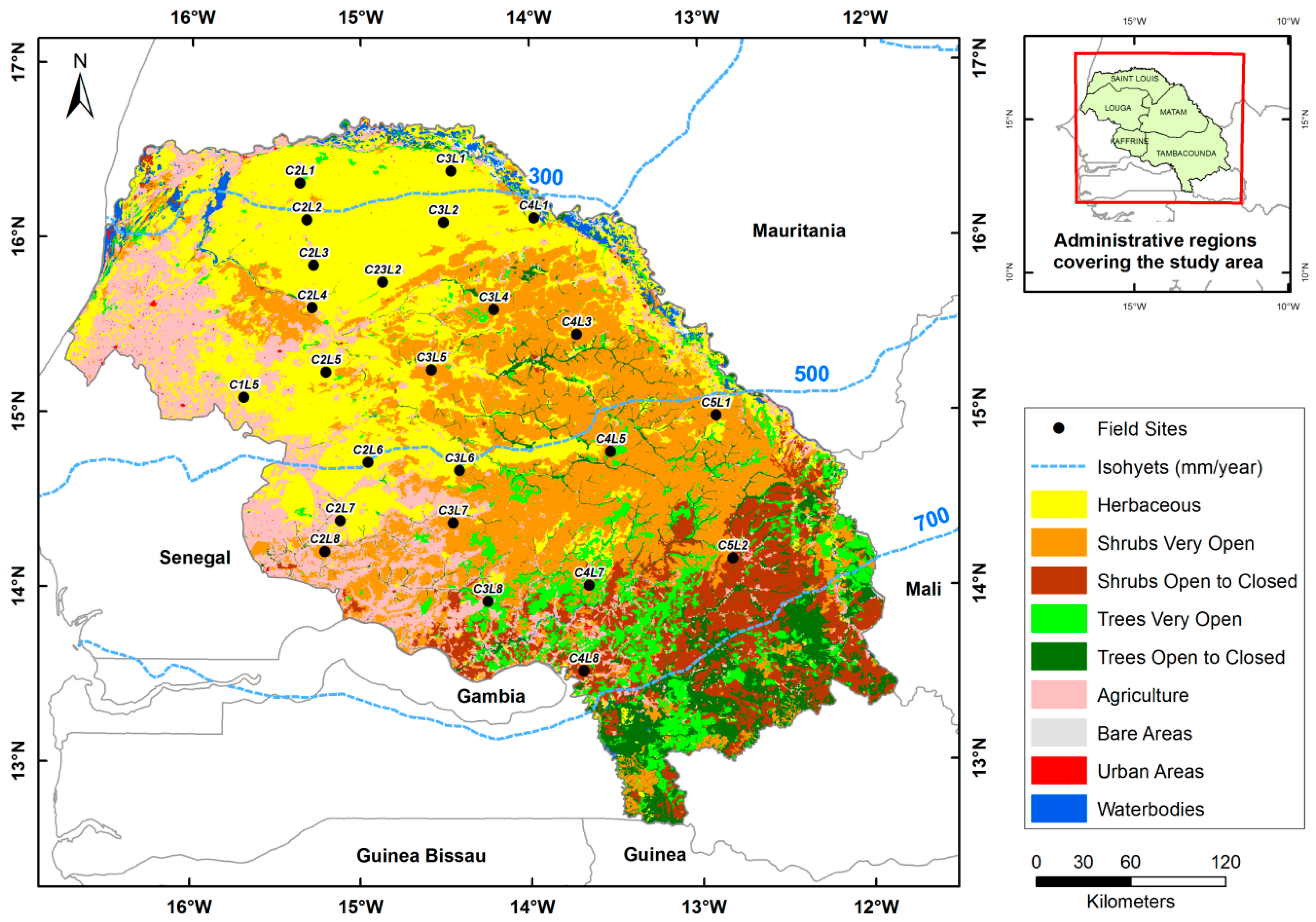
2.1. Study Area
2.2. Data and Processing
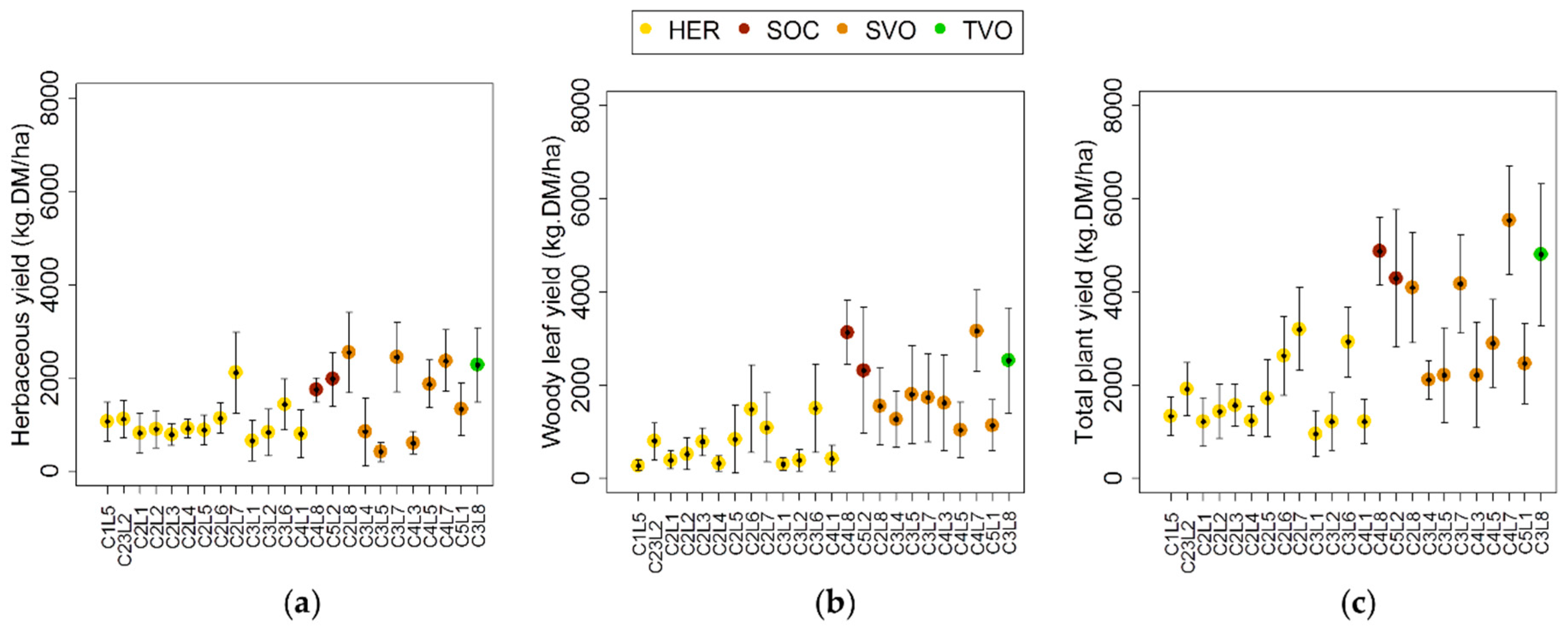
2.2.1. Historical Field Herbaceous Yields
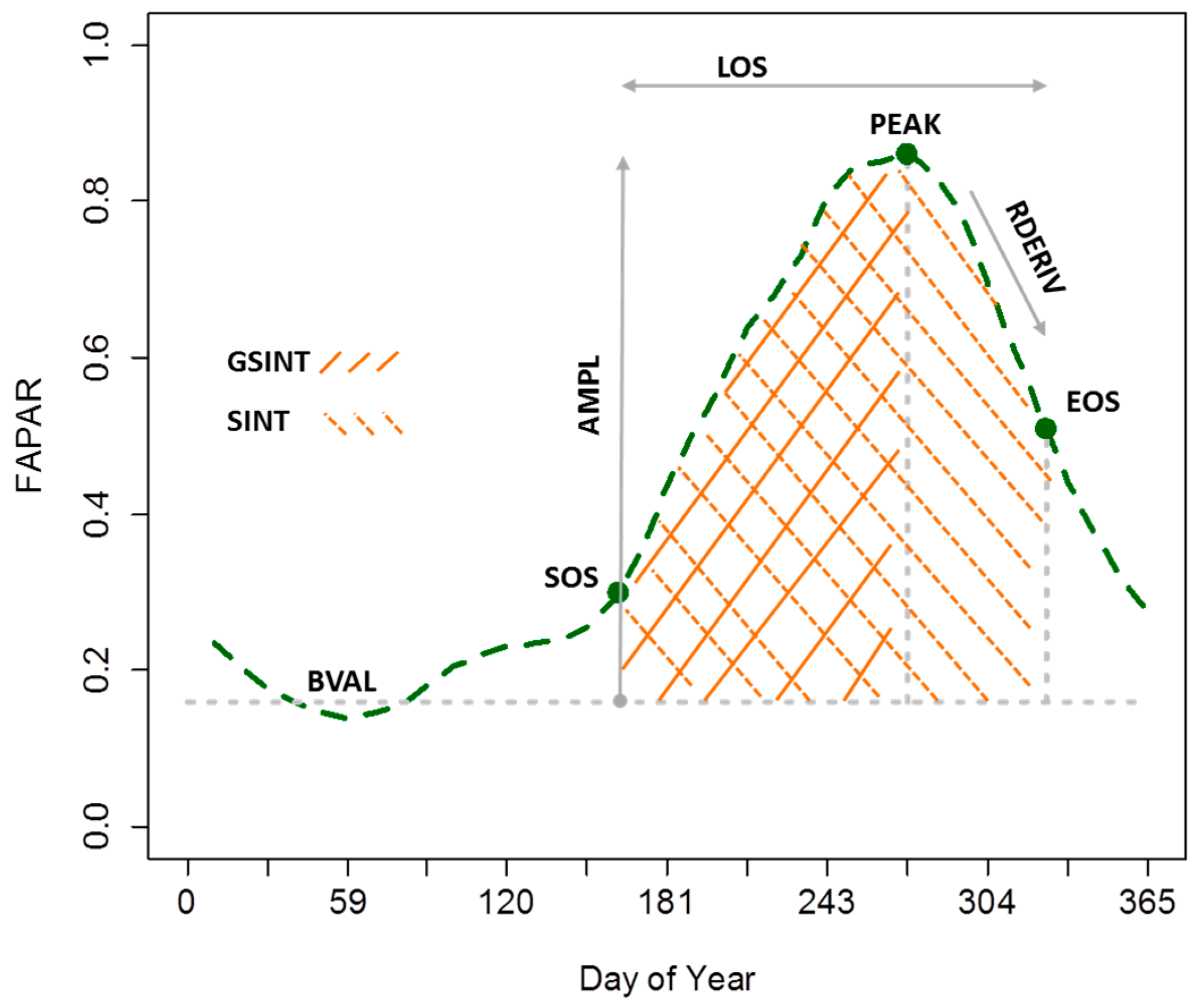
2.2.2. FAPAR Vegetation Dynamics and Calculated Metrics
2.2.3. Obtaining Agrometeorological Data
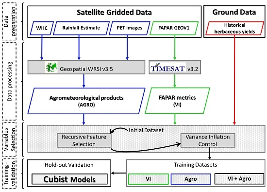
2.3. Methods
2.3.1. Explanatory Variable Selection for Herbaceous Mass Estimation
2.3.2. Rule-Based Regression Tree and Model Building
2.3.3. Model Verification, Error Analysis and Yield Anomaly Computation
3. Results
3.1. Variable Selection and Model Development
3.2. Spatio-Temporal Comparison of the Models’ Output
3.3. Season Onset/End Derived from FAPAR and Rainfall Data
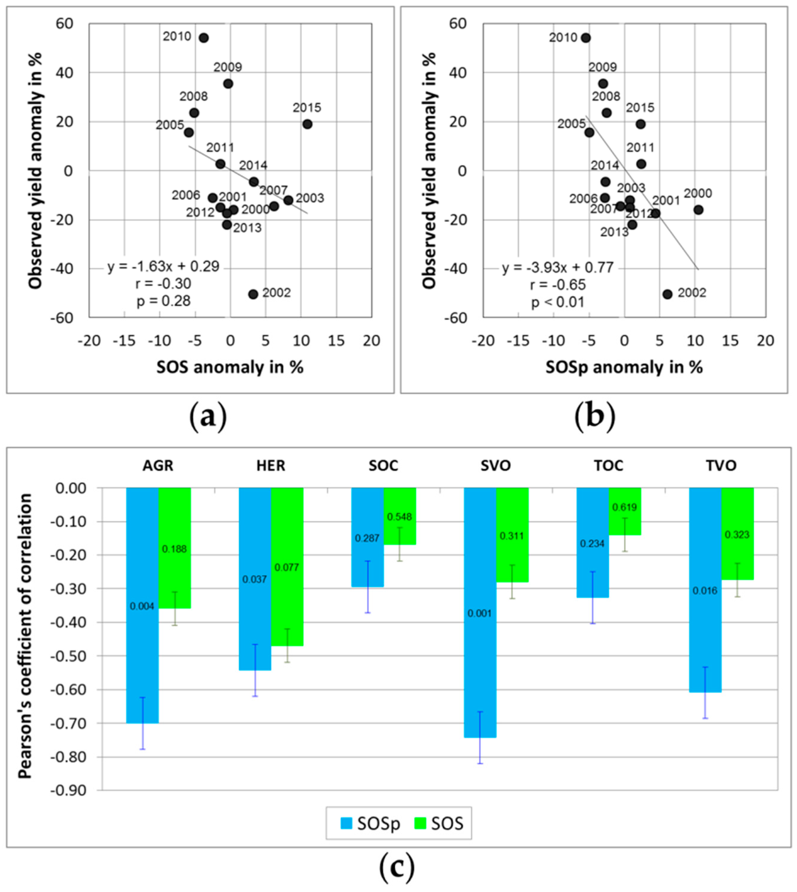
3.4. Linkage between Start of the Growing/Rainy Season and Annual Herbaceous Yield
4. Discussion
4.1. Model Development and Output Comparison
4.2. Model Applicability and Uncertainties
4.3. Management Implications of Models Results
4.4. Comparison of FAPAR and Rainfall-Based Onset/End Metrics
4.5. Early Assessment of Herbaceous Yield from Onset Metrics
5. Conclusions
Acknowledgments
Author Contributions
Conflicts of Interest
Appendix A
| Variables | Signification | Unit | Selection Status |
|---|---|---|---|
| WRSI | Water requirement satisfaction index | % | No |
| SOSp | Start of the rainy season | dekad | Yes |
| EOSp | End of the rainy season | - | No |
| AETi | Actual evapotranspiration accumulated over the initial stage of the growing season | mm | No |
| AETv | Actual evapotranspiration accumulated over the vegetative stage of the growing season | - | Yes |
| AETf | Actual evapotranspiration accumulated over the flowering stage of the growing season | - | Yes |
| AETr | Actual evapotranspiration accumulated over the ripening stage of the growing season | - | No |
| WDEFi | Water deficit accumulated over the initial stage of the growing season | - | Yes |
| WDEFv | Water deficit accumulated over the vegetative stage of the growing season | - | Yes |
| WDEFf | Water deficit accumulated over the flowering stage of the growing season | - | Yes |
| WDEFr | Water deficit accumulated over the ripening stage of the growing season | - | Yes |
| WSURi | Surplus water accumulated over the initial stage of the growing season | - | No |
| WSURv | Surplus water accumulated over the vegetative stage of the growing season | - | Yes |
| WSURf | Surplus water accumulated over the flowering stage of the growing season | - | Yes |
| WSURr | Surplus water accumulated over the ripening stage of the growing season | - | Yes |
| PPTc | Cumulated rainfall during the rainy season | - | No |
| PPTm | Averaged rainfall during the rainy season | - | No |
| Land Cover Classes | Mean Signed Difference in Dekads | |
|---|---|---|
| Start of Season | End of Season | |
| SOSp-SOS | EOSp-EOS | |
| Herbaceous | 1.3 | 0.1 |
| Agriculture | 0.3 | −1.4 |
| Shrubs very open | 0 | −2.1 |
| Shrubs open to closed | 0 | −1.7 |
| Trees very open | 0.3 | −1.6 |
| Trees open to closed | 0.4 | −2.2 |
| Overall mean | 0.4 | −1.5 |
References
- Anyamba, A.; Tucker, C.J. Analysis of sahelian vegetation dynamics using NOAA-AVHRR NDVI data from 1981–2003. J. Arid Environ. 2005, 63, 596–614. [Google Scholar] [CrossRef]
- Tagesson, T.; Fensholt, R.; Cropley, F.; Guiro, I.; Horion, S.; Ehammer, A.; Ardö, J. Dynamics in carbon exchange fluxes for a grazed semi-arid savanna ecosystem in West Africa. Agric. Ecosyst. Environ. 2015, 205, 15–24. [Google Scholar] [CrossRef]
- Carrière, M. Impact des Systèmes d’élevage Pastoraux sur L’environnement en Afrique et en asie Tropicale et Subtropicale Aride et Subaride; Technical Report; Scientific Environmental Monitoring Group—Universität des Saarlandes Institut für Biogeographie: Saarbrücken, Allemagne, 1996; p. 70. Available online: ftp://ftp.fao.org/docrep/nonfao/LEAD/x6215f/x6215F00.pdf (accessed on 23 March 2016).
- Tucker, C.J.; Vanpraet, C.; Boerwinkel, E.; Gaston, A. Satellite remote sensing of total dry matter production in the senegalese sahel. Remote Sens. Environ. 1983, 13, 461–474. [Google Scholar] [CrossRef]
- Tucker, C.J.; Vanpraet, C.L.; Sharman, M.J.; Itterstum, G.V. Satellite remote sensing of total herbaceous biomass production in the senegalese sahel: 1980–1984. Remote Sens. Environ. 1985, 17, 233–249. [Google Scholar] [CrossRef]
- Justice, C.O.; Hiernaux, P.H.Y. Monitoring the grasslands of the sahel using NOAA AVHRR data: Niger 1983. Int. J. Remote Sensi. 1986, 7, 1475–1497. [Google Scholar] [CrossRef]
- Seaquist, J.W.; Olsson, L.; Ardö, J. A remote sensing-based primary production model for grassland biomes. Ecol. Model. 2003, 169, 131–155. [Google Scholar] [CrossRef]
- Dardel, C.; Kergoat, L.; Hiernaux, P.; Mougin, E.; Grippa, M.; Tucker, C.J. Re-greening sahel: 30 years of remote sensing data and field observations (Mali, Niger). Remote Sens. Environ. 2014, 140, 350–364. [Google Scholar] [CrossRef]
- Tian, F.; Fensholt, R.; Verbesselt, J.; Grogan, K.; Horion, S.; Wang, Y. Evaluating temporal consistency of long-term global NDVI datasets for trend analysis. Remote Sens. Environ. 2015, 163, 326–340. [Google Scholar] [CrossRef]
- Baret, F.; Weiss, M.; Lacaze, R.; Camacho, F.; Makhmara, H.; Pacholcyzk, P.; Smets, B. Geov1: LAI and FAPAR essential climate variables and FCOVER global time series capitalizing over existing products. Part1: Principles of development and production. Remote Sens. Environ. 2013, 137, 299–309. [Google Scholar] [CrossRef]
- Prince, S.D. Satellite remote sensing of primary production: Comparison of results for sahelian grasslands 1981–1988. Int. J. Remote Sens. 1991, 12, 1301–1311. [Google Scholar] [CrossRef]
- Prince, S.D.; Goward, S.N. Global primary production: A remote sensing approach. J. Biogeogr. 1995, 22, 815–835. [Google Scholar] [CrossRef]
- Meroni, M.; Fasbender, D.; Kayitakire, F.; Pini, G.; Rembold, F.; Urbano, F.; Verstraete, M.M. Early detection of biomass production deficit hot-spots in semi-arid environment using FAPAR time series and a probabilistic approach. Remote Sens. Environ. 2014, 142, 57–68. [Google Scholar] [CrossRef]
- Meroni, M.; Rembold, F.; Verstraete, M.; Gommes, R.; Schucknecht, A.; Beye, G. Investigating the relationship between the inter-annual variability of satellite-derived vegetation phenology and a proxy of biomass production in the sahel. Remote Sens. 2014, 6, 5868–5884. [Google Scholar] [CrossRef] [Green Version]
- Brandt, M.; Hiernaux, P.; Tagesson, T.; Verger, A.; Rasmussen, K.; Diouf, A.A.; Mbow, C.; Mougin, E.; Fensholt, R. Woody plant cover estimation in drylands from earth observation based seasonal metrics. Remote Sens. Environ. 2016, 172, 28–38. [Google Scholar] [CrossRef]
- Diouf, A.; Brandt, M.; Verger, A.; Jarroudi, M.; Djaby, B.; Fensholt, R.; Ndione, J.; Tychon, B. Fodder biomass monitoring in sahelian rangelands using phenological metrics from FAPAR time series. Remote Sens. 2015, 7, 9122–9148. [Google Scholar] [CrossRef]
- Funk, C.C.; Brown, M.E. Intra-seasonal NDVI change projections in semi-arid Africa. Remote Sens. Environ. 2006, 101, 249–256. [Google Scholar] [CrossRef]
- Cornet, A. Utilisation de modéles simples de bilan hydrique et de production de biomasse pour déterminer les potentialités de production de parcours en zone sahélienne sénégalaise. In Proceedings of the Workshop on Land Evaluation for Extensive Grazing, Wageningen, The Netherlands, 31 October–4 November 1984; pp. 207–228.
- Hickler, T.; Eklundh, L.; Seaquist, J.W.; Smith, B.; Ardö, J.; Olsson, L.; Sykes, M.T.; Sjöström, M. Precipitation controls sahel greening trend. Geophys. Res. Lett. 2005, 32, L21415. [Google Scholar] [CrossRef]
- Ali, A. Variabilité et changements du climat au sahel : Ce que l’observation nous apprend sur la situation actuelle. Grain de sel 2010, 49, 13–14. [Google Scholar]
- Huber, S.; Fensholt, R. Analysis of teleconnections between AVHRR-based sea surface temperature and vegetation productivity in the semi-arid sahel. Remote Sens. Environ. 2011, 115, 3276–3285. [Google Scholar] [CrossRef]
- Brandt, M.; Mbow, C.; Diouf, A.A.; Verger, A.; Samimi, C.; Fensholt, R. Ground and satellite based evidence of the biophysical mechanisms behind the greening sahel. Glob. Chang. Biol. 2015, 1610–1620. [Google Scholar] [CrossRef] [PubMed]
- Ibrahim, Y.; Balzter, H.; Kaduk, J.; Tucker, C. Land degradation assessment using residual trend analysis of Gimms NDVI3g, soil moisture and rainfall in sub-saharan West Africa from 1982 to 2012. Remote Sens. 2015, 7, 5471–5494. [Google Scholar] [CrossRef]
- Penning de Vries, F.W.T.; Djitèye, M.A. La Productivité des Pâturages Sahéliens: Une Étude des Sols, des Végétations et de L’exploitation de Cette Ressource Naturelle; Centre for Agricultural Publishing and Documentation: Wageningen, The Netherlands, 1982; p. 525. [Google Scholar]
- Breman, H.; De Ridder, N. Manuel Sur Les Pâturages des Pays Sahéliens; CTA: Wageningen, The Netherlands, 1991; p. 481. [Google Scholar]
- Tarnavsky, E.; Grimes, D.; Maidment, R.; Black, E.; Allan, R.; Stringer, M.; Chadwick, R.; Kayitakire, F. Extension of the tamsat satellite-based rainfall monitoring over Africa and from 1983 to present. J. Appl. Meteorol. Climatol. 2014, 53, 2805–2822. [Google Scholar] [CrossRef]
- Xie, P.; Arkin, P.A. Analysis of global monthly precipitation using gauge observations, satellite estimates, and numerical model prediction. J. Clim. 1996, 9, 840–858. [Google Scholar] [CrossRef]
- Novella, N.S.; Thiaw, W.M. African rainfall climatology version 2 for famine early warning systems. J. Appl. Meteorol. Climatol. 2013, 52, 588–606. [Google Scholar] [CrossRef]
- Hiernaux, P. Distribution des pluies et production herbacée au sahel:Une méthode empirique pour caractériser la distribution des précipitations journalières et ses effets sur la production herbacée. In Premiers Résultats Acquis Dans le Sahel Malien; Doc. Prog. N AZ 98; CIPEA: Bamako, Mali, 1983. [Google Scholar]
- CSE. Rapport sur l’état de l’environnement au sénégal; Centre de Suivi Ecologique: Dakar, Senegal, 2010; p. 266. [Google Scholar]
- Breshears, D.; Barnes, F. Interrelationships between plant functional types and soil moisture heterogeneity for semiarid landscapes within the grassland/forest continuum: A unified conceptual model. Landsc. Ecol. 1999, 14, 465–478. [Google Scholar] [CrossRef]
- Hiernaux, P.; Ayantunde, A.; Kalilou, A.; Mougin, E.; Gérard, B.; Baup, F.; Grippa, M.; Djaby, B. Trends in productivity of crops, fallow and rangelands in southwest niger: Impact of land use, management and variable rainfall. J. Hydrol. 2009, 375, 65–77. [Google Scholar]
- Hiernaux, P.; Mougin, E.; Diarra, L.; Soumaguel, N.; Lavenu, F.; Tracol, Y.; Diawara, M. Sahelian rangeland response to changes in rainfall over two decades in the Gourma region, Mali. J. Hydrol. 2009, 375, 114–127. [Google Scholar]
- Rojas, O.; Rembold, F.; Royer, A.; Negre, T. Real-time agrometeorological crop yield monitoring in Eastern Africa. Agron. Sustain. Dev. 2005, 25, 63–77. [Google Scholar]
- Doorenbos, J.; Pruitt, W.O. Guidelines for Predicting Crop Water Requirements; FAO Irrigation and Drainage paper No. 24; FAO: Rome, Italy, 1977. [Google Scholar]
- Frère, M.; Popov, G. Agrometeorological Crop Monitoring and Forecasting; FAO plant production and protection paper No. 17.; FAO: Rome, Italy, 1979. [Google Scholar]
- Verdin, J.; Klaver, R. Grid cell based crop water accounting for the famine early warning system. Hydrol. Proces. 2002, 16, 617–1630. [Google Scholar]
- Senay, G.B.; Verdin, J. Evaluating the performance of a crop water balance model in estimating regional crop production. In Proceedings of the Pecora 15/Land Satellite Information IV/ISPRS Commission I/FIEOS 2002 Conference, Denver, CO, USA, 10–15 November 2002.
- Senay, G.B.; Verdin, J.P.; Rowland, J. Developing an operational rangeland water requirement satisfaction index. Int.J. Remote Sens. 2011, 32, 6047–6053. [Google Scholar]
- Mougin, E.; Lo Seena, D.; Rambal, S.; Gaston, A.; Hiernaux, P. A regional sahelian grassland model to be coupled with multispectral satellite data. I: Model description and validation. Remote Sens. Environ. 1995, 52, 181–193. [Google Scholar] [CrossRef]
- Rudorff, B.F.T.; Batista, G.T. Yield estimation of sugarcane based on agrometeorological-spectral models. Remote Sens. Environ. 1990, 33, 183–192. [Google Scholar] [CrossRef]
- Stancioff, A.; Staljanssens, M.; Tappan, G. Mapping and Remote Sensing of the Resources of the Republic of Senegal: A study of the Geology, Hydrology, Soils, Vegetation and Land use Potential; SDSU-RSI-86-01; Remote Sensing Institute of South Dakota State University: Brookings, SD, USA, 1986. [Google Scholar]
- Herman, A.; Kumar, V.B.; Arkin, P.A.; Ko Usky, J.V. Objectively determined 10-day african rainfall estimates created for famine early warning systems. Int. J. Remote Sens. 1997, 18, 2147–2159. [Google Scholar] [CrossRef]
- Xie, P.; Arkin, P.A. A 17-year monthly analysis based on gauge observations, satellite estimates, and numerical model outputs. Bull. Am. Meteorol. Soc. 1997, 78, 2539–2558. [Google Scholar] [CrossRef]
- Maignen, R. Notice explicative, carte pédologique du sénégal au 1/1.000.000; Publication ORSTOM: Dakar, Sénégal, 1965. [Google Scholar]
- Tappan, G.G.; Sall, M.; Wood, E.C.; Cushing, M. Ecoregions and land cover trends in senegal. J. Arid Environ. 2004, 59, 427–462. [Google Scholar] [CrossRef]
- Valenza, J. Dynamisme de quelques types de pâturages naturels sahélo-soudaniens en république du sénégal. In Proceedings of the XIIIe International Grassland Congress, Leipzig, Allemagne, 18–27 May 1977.
- Hiernaux, P.; Le Houérou, H.N. Les parcours du sahel. Sécheresse 2006, 17, 51–71. [Google Scholar]
- CSE. Suivi de la Production Végétale 2013 au Sénégal; National Report; Centre de Suivi Ecologique of Dakar: Dakar, Senegal, 2013. [Google Scholar]
- CSE. Suivi de la Production Végétale 2014 au Sénégal; National Report; Centre de Suivi Ecologique of Dakar: Dakar, Senegal, 2014. [Google Scholar]
- FAO. Global Land Cover Network: Senegal Land Cover Mapping. Available online: http://www.Glcn.Org/databases/se_landcover_en.Jsp (accessed on 2 November 2015).
- FAO. Land Cover Changes: Senegal 1990–2005. 2009. Available online: http://www.glcn.org/downs/prj/senegal/Sen_lc_change_report_dec08.pdf (accessed on 2 November 2015).
- FAO. Senegal Land Cover Mapping. 2009. Available online: http://www.glcn.org/downs/prj/senegal/Sen_lc_report_dec08.pdf (accessed on 27 August 2015).
- FAO. Senegal Land Cover Classes Description. 2009. Available online: http://www.glcn.org/downs/prj/senegal/Sen_lc_classes_descr_dec08.pdf (accessed on 2 November 2015).
- Diouf, A.; Sall, M.; Wélé, A.; Dramé, M. Méthode d’échantillonnage de la production primaire sur le terrain; Document technique; Centre de suivi écologique de Dakar: Dakar, Sénégal, 1998. [Google Scholar]
- Verger, A.; Baret, F.; Weiss, M.; Filella, I.; Peñuelas, J. Geoclim: A global climatology of LAI, FAPAR, and FCOVER from vegetation observations for 1999–2010. Remote Sens. Environ. 2015. [Google Scholar] [CrossRef]
- Jönsson, P.; Eklundh, L. Timesat—A program for analyzing time-series of satellite sensor data. Comput. Geosci. 2004, 30, 833–845. [Google Scholar] [CrossRef]
- Chen, J.; Jönsson, P.; Tamura, M.; Gu, Z.; Matsushita, B.; Eklundh, L. A simple method for reconstructing a high-quality NDVI time-series data set based on the Savitzky–Golay filter. Remote Sens. Environ. 2004, 91, 332–344. [Google Scholar] [CrossRef]
- Fensholt, R.; Anyamba, A.; Stisen, S.; Sandholt, I.; Pak, E.; Small, J. Comparisons of compositing period length for vegetation index data from polar-orbiting and geostationary satellites for the cloud-prone region of West Africa. Photogramm. Eng. Remote Sens. 2007, 73, 297–309. [Google Scholar] [CrossRef]
- Senay, G. Crop Water Requirement Satisfaction Index (WRSI): Model Description. 2004. Available online: http://iridl.ldeo.columbia.edu/documentation/usgs/adds/wrsi/WRSI_readme.pdf (accessed on 17 July 2015).
- Senay, G.B.; Verdin, J. Characterization of yield reduction in ethiopia using a GIS-based crop water balance model. Can. J. Remote Sens. 2003, 29, 687–692. [Google Scholar] [CrossRef]
- Senay, G.B.; Verdin, J. Using a GIS-based water balance model to assess regional crop performance. In Proceedings of the Fifth International Workshop on Application of Remote Sensing in Hydrology, Montpellier, France, 2–5 October 2001.
- Senay, G. Modeling landscape evapotranspiration by integrating land surface phenology and a water balance algorithm. Algorithms 2008, 1, 52–68. [Google Scholar] [CrossRef]
- Shuttleworth, J. Evaporation. In Handbook of Hydrology; Maidment, D., Ed.; McGraw-Hill: New York, NY, USA, 1992; pp. 1–4. [Google Scholar]
- Climate Hazard Group. Rainfall Estimate and Potential Evapotranspiration Data. Available online: Ftp://ftp.Chg.Ucsb.Edu/pub/org/chg/products/geowrsi/archives/ (accessed on 18 December 2015).
- FEWS NET. Fews Data Downloads. Available online: Http://earlywarning.Usgs.Gov/fews/datadownloads (accessed on 18 december 2015).
- FAO. Digital Soil Map of the World (CDROM); Food and Agriculture Organization of the United Nations: Rome, Italy, 1994. [Google Scholar]
- Allen, R.G.; Pereira, L.S.; Raes, D.; Smith, M. Crop Evapotranspiration; FAO Irrigation and Drainage Paper No. 56; FAO: Rome, Italy, 1998. [Google Scholar]
- AGRHYMET. Méthodologie de suivi des zones à risque. In Agrhymet flash, bulletin de suivi de la campagne agricole au sahel 0/96; AGRHYMET: Niamey, Niger, 1996; Volume 2, pp. 1–2. [Google Scholar]
- Domingos, P. A few useful things to know about machine learning. Commun. ACM 2012, 55, 78–87. [Google Scholar] [CrossRef]
- De Benedetto, D.; Castrignanò, A.; Quarto, R. A geostatistical approach to estimate soil moisture as a function of geophysical data and soil attributes. Proc. Environ. Sci. 2013, 19, 436–445. [Google Scholar] [CrossRef]
- Fraser, R.H.; Li, Z. Estimating fire-related parameters in boreal forest using spot vegetation. Remote Sens. Environ. 2002, 82, 95–110. [Google Scholar] [CrossRef]
- Zhang, C.; Kovacs, J.; Liu, Y.; Flores-Verdugo, F.; Flores-de-Santiago, F. Separating mangrove species and conditions using laboratory hyperspectral data: A case study of a degraded mangrove forest of the mexican pacific. Remote Sens. 2014, 6, 11673–11688. [Google Scholar] [CrossRef]
- Hastie, T.; Tibshirani, R.; Friedman, J. The Elements of Statistical Learning: Data Mining, Inference, and Prediction; Springer-Verlag: New York, NY, USA, 2009. [Google Scholar]
- Kuhn, M.; Johnson, K. Applied Predictive Modeling; Springer: New York, NY, USA, 2013. [Google Scholar]
- Guyon, I.; Weston, J.; Barnhill, S.; Vapnik, V. Gene selection for cancer classification using support vector machines. Mach. Learn. 2002, 46, 389–422. [Google Scholar] [CrossRef]
- Marill, T.; Green, D.M. On the effectiveness of receptors in recognition systems. IEEE Trans. Inf. Theory 1963, 9, 11–17. [Google Scholar] [CrossRef]
- Kuhn, M.; Wing, J.; Weston, S.; Williams, A.; Keefer, C.; Engelhardt, A.; Cooper, T.; Mayer, Z.; The R Core Team. Caret: Classification and Regression Training, R Package Version 6.0–24. Available online: Http://cran.R-project.Org/package=caret (accessed on 25 June 2015).
- Liaw, A.; Wiener, M. Classification and regression by randomforest. R News 2002, 2, 18–22. [Google Scholar]
- Belsley, D.A.; Kuh, E.; Welsh, R.E. Regression Diagnostics: Identifying Influential Data and Sources of Collinearity; John Wiley & Sons: New York, NY, USA, 1980. [Google Scholar]
- Herrmann, S.; Wickhorst, A.; Marsh, S. Estimation of tree cover in an agricultural parkland of senegal using rule-based regression tree modeling. Remote. Sens. 2013, 5, 4900–4918. [Google Scholar] [CrossRef]
- Brosofske, K.D.; Froese, R.E.; Falkowski, M.J.; Banskota, A. A review of methods for mapping and prediction of inventory attributes for operational forest management. For. Sci. 2014, 60, 733–756. [Google Scholar] [CrossRef]
- White, A.B.; Kumar, P.; Tcheng, D. A data mining approach for understanding topographic control on climate-induced inter-annual vegetation variability over the united states. Remote Sens. Environ. 2005, 98, 1–20. [Google Scholar] [CrossRef]
- Kuhn, M.; Weston, S.; Keefer, C.; Coulter, N. Cubist Models for Regression. 2012. Available online: http://cran.r-project.org/web/packages/Cubist/vignettes/cubist.pdf (accessed on 25 June 2015).
- Kohavi, R. A study of cross-validation and bootstrap for accuracy estimation and model selection. Int. J. Conf. Artif. Int. 1995, 14, 1137–1145. [Google Scholar]
- Refaeilzadeh, P.; Tang, L.; Liu, H. Cross-validation. In Encyclopedia of Database Systems; Liu, L., ÖZsu, M.T., Eds.; Springer: Heidelberg, Germany, 2009; pp. 532–538. [Google Scholar]
- Jin, Y.; Yang, X.; Qiu, J.; Li, J.; Gao, T.; Wu, Q.; Zhao, F.; Ma, H.; Yu, H.; Xu, B. Remote sensing-based biomass estimation and its spatio-temporal variations in temperate grassland, Northern China. Remote Sens. 2014, 6, 1496–1513. [Google Scholar] [CrossRef]
- Tian, F.; Brandt, M.; Liu, Y.Y.; Verger, A.; Tagesson, T.; Diouf, A.A.; Rasmussen, K.; Mbow, C.; Wang, Y.; Fensholt, R. Remote sensing of vegetation dynamics in drylands: Evaluating vegetation optical depth (VOD) using AVHRR NDVI and in situ green biomass data over west African Sahel. Remote Sens. Environ. 2016, 177, 265–276. [Google Scholar] [CrossRef]
- Diouf, A.A.; Djaby, B.; Diop, M.B.; Wele, A.; Ndione, J.-A.; Tychon, B. Fonctions d’ajustement pour l’estimation de la production fourragère herbacée des parcours naturels du sénégal à partir du ndvi s10 de spot-vegetation. In Proceedings of the XXVIIe Colloq. de l’Asso. Int. de Climatol, Dijon, France, 2–5 July 2014; pp. 284–289.
- Xiaoping, W.; Ni, G.; Kai, Z.; Jing, W. Hyperspectral remote sensing estimation models of aboveground biomass in gannan rangelands. Proc. Environ. Sci. 2011, 10, 697–702. [Google Scholar] [CrossRef]
- Santin-Janin, H.; Garel, M.; Chapuis, J.L.; Pontier, D. Assessing the performance of NDVI as a proxy for plant biomass using non-linear models: A case study on the kerguelen archipelago. Polar Biol. 2009, 32, 861–871. [Google Scholar] [CrossRef]
- Huete, A.; Didan, K.; Miura, T.; Rodriguez, E.P.; Gao, X.; Ferreira, L.G. Overview of the radiometric and biophysical performance of the modis vegetation indices. Remote Sens. Environ. 2002, 83, 195–213. [Google Scholar] [CrossRef]
- Touré, I.; Ickowicz, A.; Wane, A.; Garba, I.; Gerber, P.; Atté, I.; Cesaro, J.D.; Diop, A.T.; Djibo, S.; Ham, F.; et al. Atlas of Trends in Pastoral Systems in Sahel; FAO and CIRAD: Montpellier, France, 2012. [Google Scholar]
- Ikegami, M.; Barrett, C.B.; Chantarat, S. Dynamic effects of index based livestock insurance on household intertemporal behavior and welfare. In Proceedings of the Research Conference on Microinsurance, Twente, The Netherlands, 11–12 April 2012.
- Chantarat, S.; Mude, A.G.; Barrett, C.B.; Carter, M.R. Designing index based livestock insurance for managing asset risk in Nothern Kenya. J. Risk Insur. 2013, 80, 205–237. [Google Scholar] [CrossRef]
- Fitzpatrick, R.G.J.; Bain, C.L.; Knippertz, P.; Marsham, J.H.; Parker, D.J. The West African monsoon onset: A concise comparison of definitions. J. Clim. 2015, 28, 8673–8694. [Google Scholar] [CrossRef]
- Marteau, R.; Moron, V.; Philippon, N. Spatial coherence of monsoon onset over western and central sahel (1950–2000). J. Clim. 2009, 22, 1313–1324. [Google Scholar] [CrossRef]
- Omotosho, J.B.; Balogun, A.A.; Ogunjobi, K. Predicting monthly and seasonal rainfall, onset and cessation of the rainy season in west africa using only surface data. Int. J. Climatol. 2000, 20, 865–880. [Google Scholar] [CrossRef]
- Sivakumar, M.V.K. Predicting rainy season potential from the onset of rains in southern sahelian and sudanian climatic zones of West Africa. Agric. For. Meteorol. 1988, 42, 295–305. [Google Scholar] [CrossRef]
- Ali, M.; Saadou, M.; Jean, L. Phénologie de quelques espèces ligneuses du parc national du «W» (Niger). Science et Changements Planétaires/Sécheresse 2007, 18, 354–358. [Google Scholar]
- Devineau, J.-L. Seasonal rhythms and phenological plasticity of savanna woody species in a fallow farming system (South-West Burkina Faso). J. Trop. Ecol. 1999, 15, 497–513. [Google Scholar] [CrossRef]
- Hiernaux, P.H.Y.; Cissé, M.I.; Diarra, L.; De Leeuw, P.N. Fluctuations saisonnières de la feuillaison des arbres et des buissons sahéliens. Conséquences pour la quantification des ressources fourragères. Revue D’élevage et de Médecine Vétérinaire des Pays Tropicaux 1994, 47, 117–125. [Google Scholar]
- Proud, S.R.; Zhang, Q.; Schaaf, C.; Fensholt, R.; Rasmussen, M.O.; Shisanya, C.; Mutero, W.; Mbow, C.; Anyamba, A.; Pak, E.; et al. The normalization of surface anisotropy effects present in seviri reflectances by using the modis brdf method. IEEE Tran. Geosci. Remote Sens. 2014, 52, 6026–6039. [Google Scholar] [CrossRef]
- Mbow, C.; Fensholt, R.; Rasmussen, K.; Diop, D. Can vegetation productivity be derived from greenness in a semi-arid environment? Evidence from ground-based measurements. J. Arid Environ. 2013, 97, 56–65. [Google Scholar] [CrossRef]
- Vintrou, E.; Bégué, A.; Baron, C.; Saad, A.; Lo Seen, D.; Traoré, S. A comparative study on satellite and model-based crop phenology in West Africa. Remote Sens. 2014, 6, 1367–1389. [Google Scholar] [CrossRef] [Green Version]
- Begue, A.; Vintrou, E.; Saad, A.; Hiernaux, P. Differences between cropland and rangeland MODIS phenology (start-of-season) in Mali. Int. J. Appl. Earth Obs. Geoinf. 2014, 31, 167–170. [Google Scholar] [CrossRef]
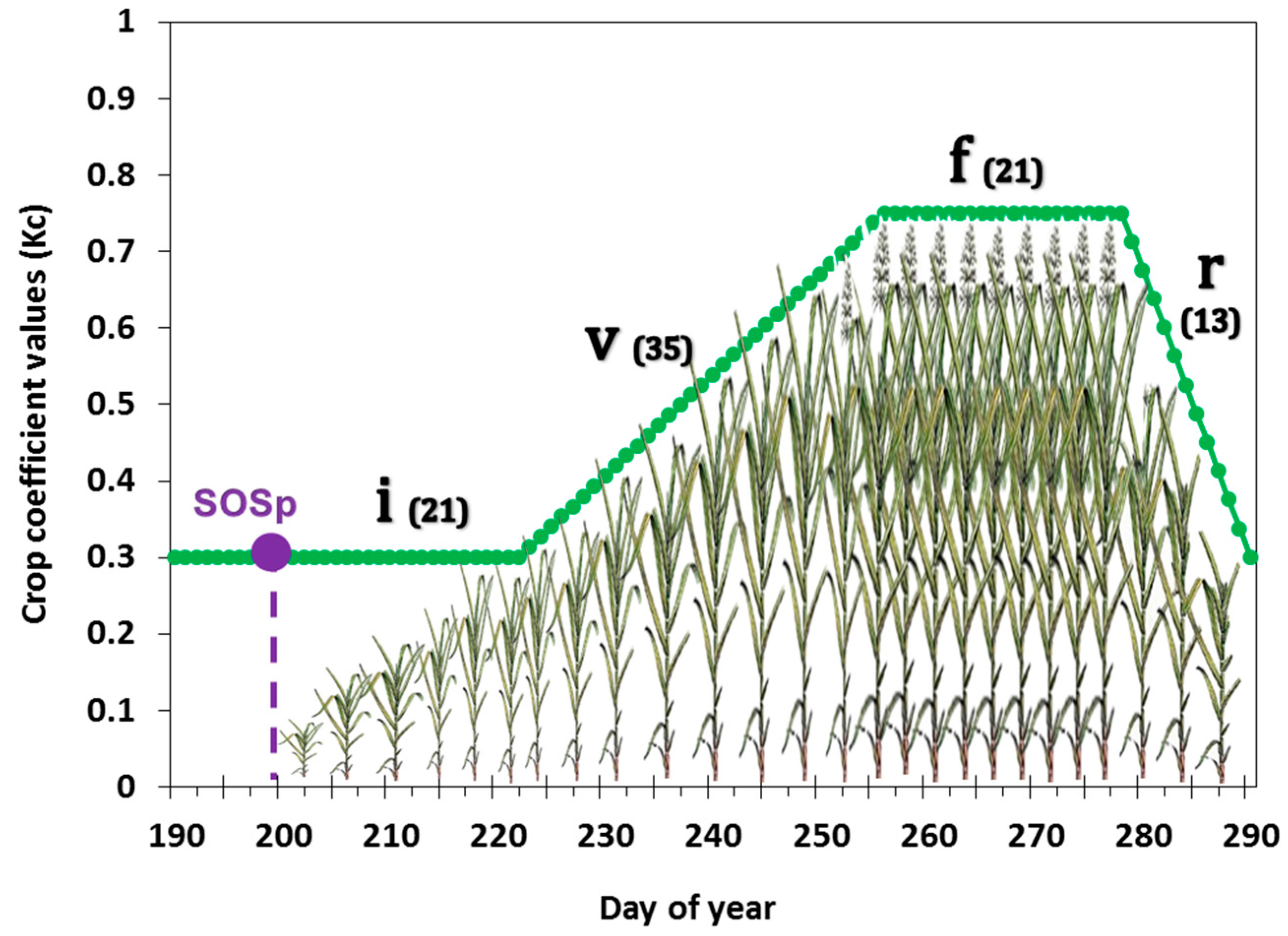
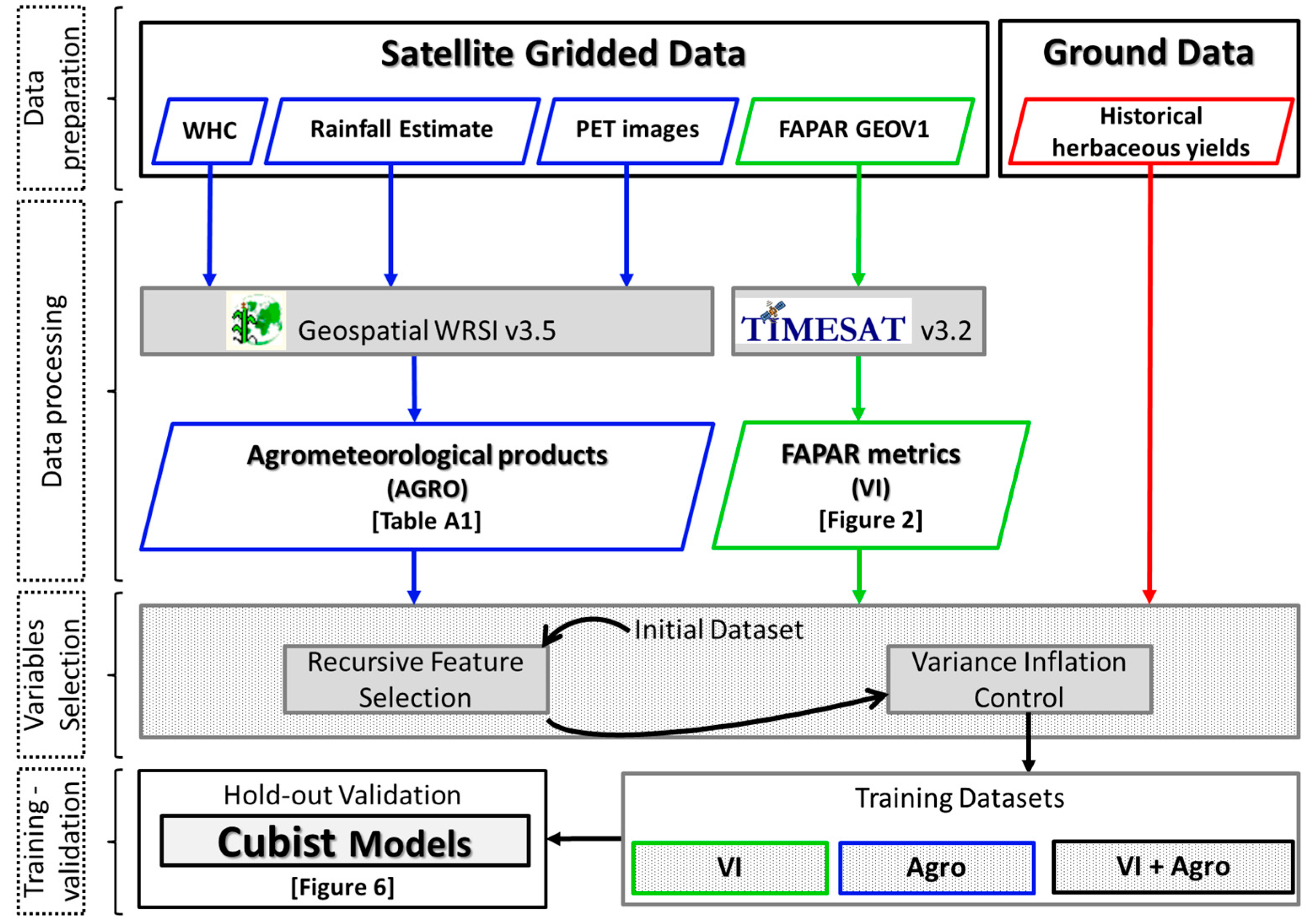
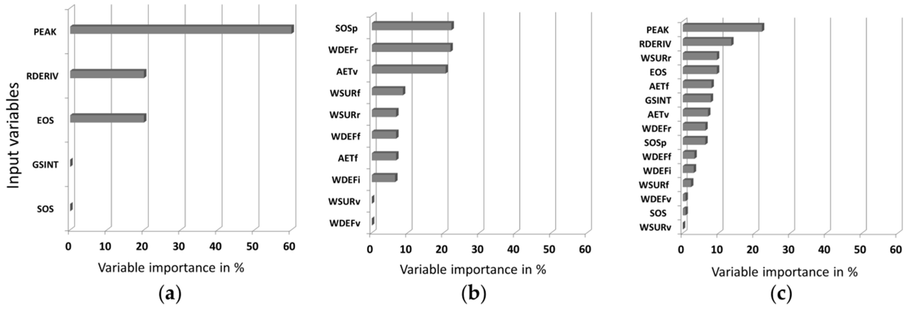
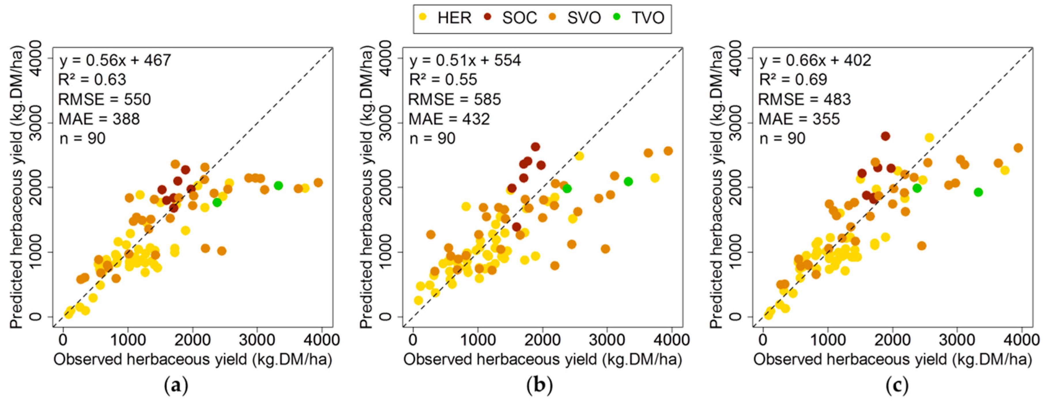
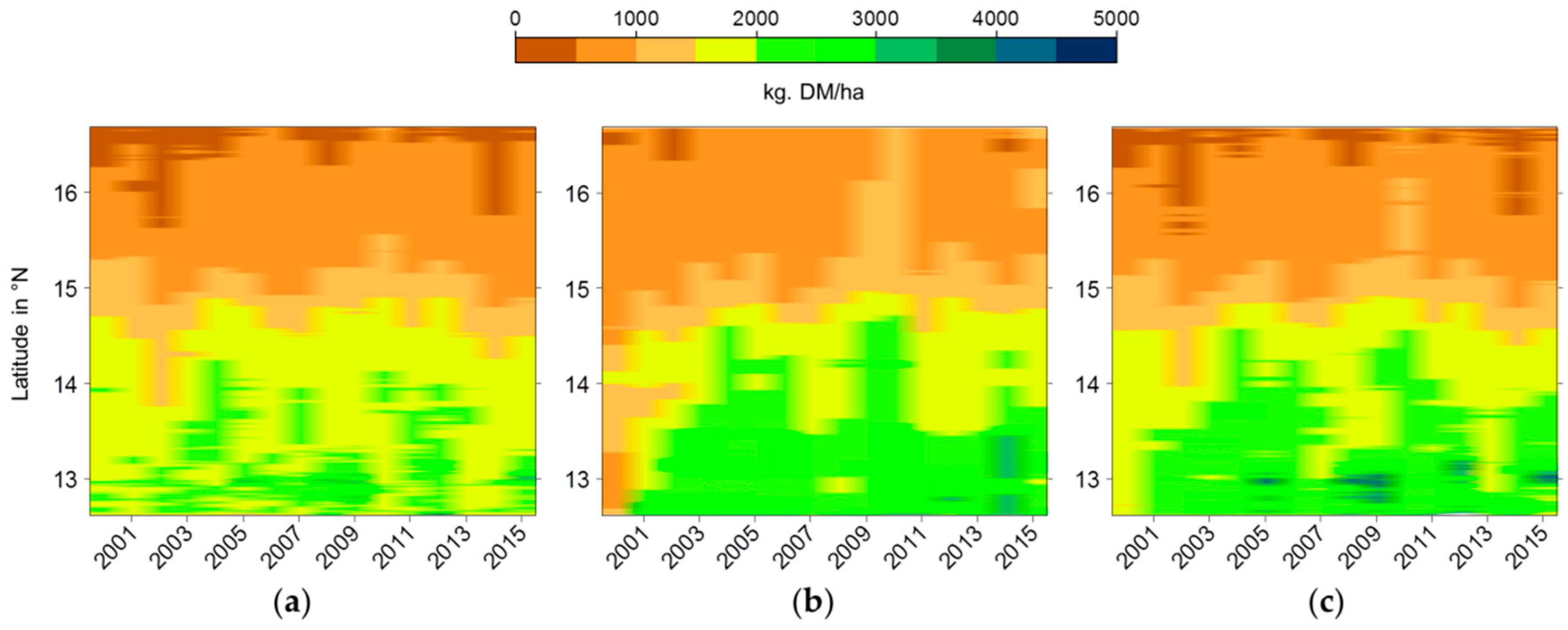
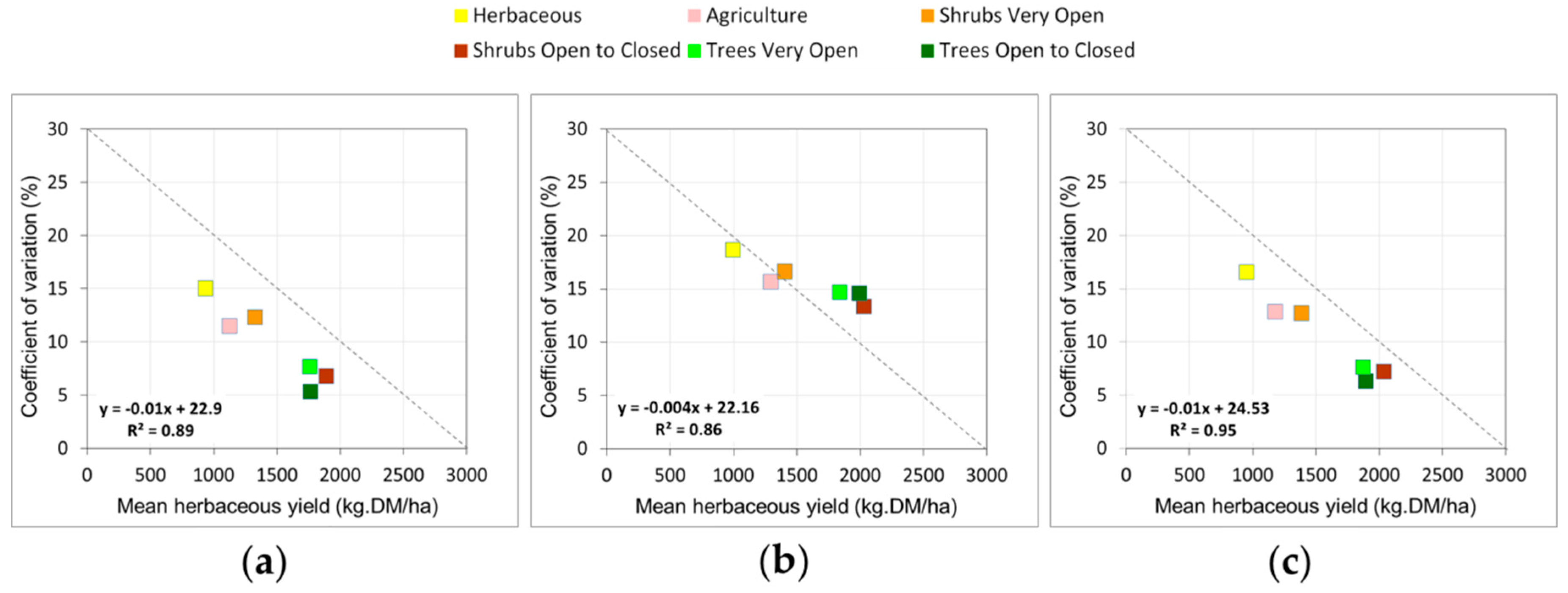
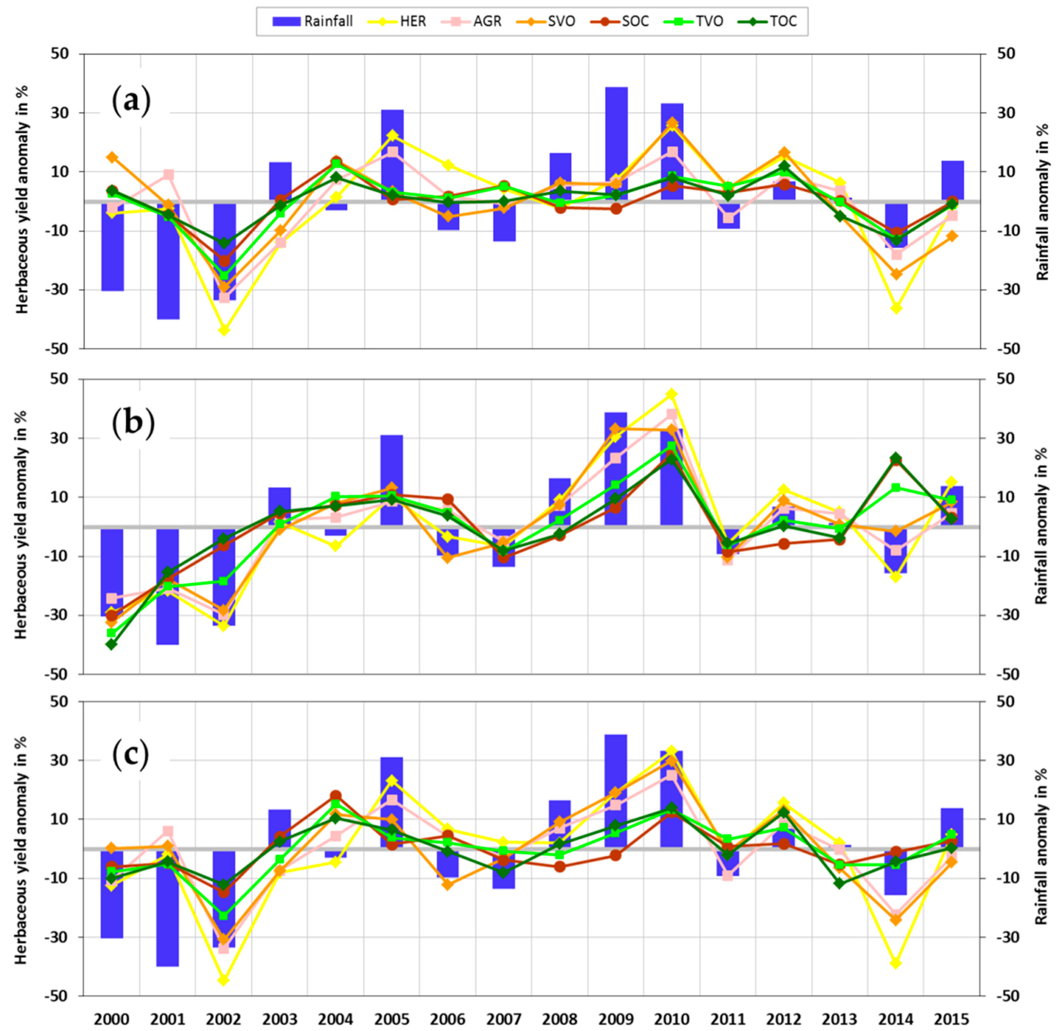
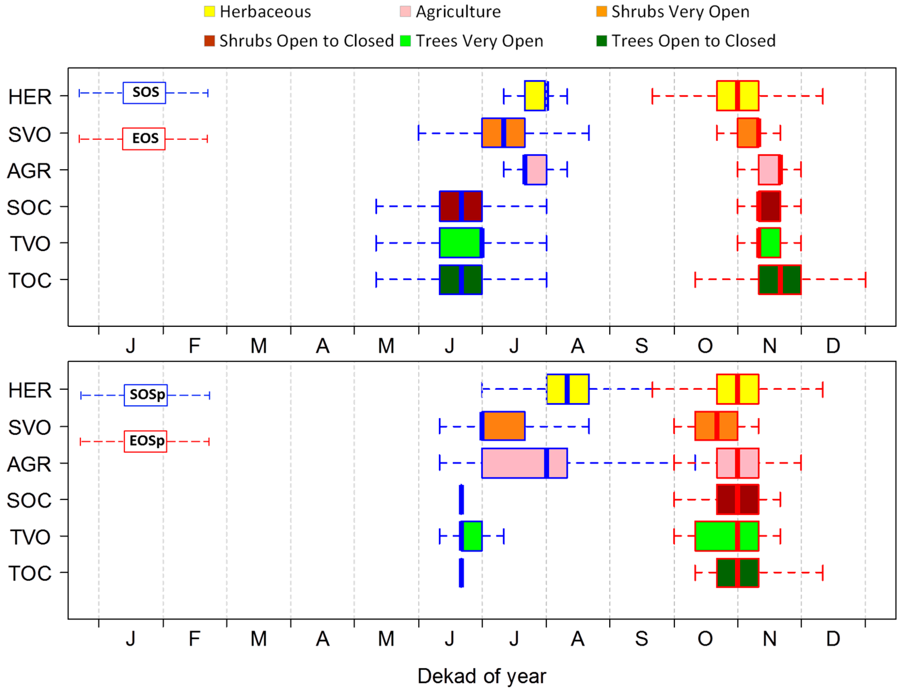
| Land Cover Class | Abbreviation | Short Description | Area (km²) | Area (%) | Woody Cover (%) | Number of Sites |
|---|---|---|---|---|---|---|
| Herbaceous | HER | Open to closed herbaceous vegetation with sparse trees and shrubs | 38,043 | 30.53 | 9 | 13 |
| Shrubs very open | SVO | Very open shrubs | 33,724 | 27.07 | 17 | 8 |
| Shrubs open to closed | SOC | Open to closed shrubs | 12,155 | 9.75 | 28 | 2 |
| Trees very open | TVO | Very open trees, gallery forest | 8889 | 7.13 | 25 | 1 |
| Trees open to closed | TOC | Open to closed trees, gallery forest | 9274 | 7.44 | 25 | 0 |
| Agriculture | AGR | Large to small tree plantations and rainfed herbaceous crops | 19,483 | 15.64 | 14 | 0 |
| Other classes | - | Bare areas, urban areas and water bodies | 3041 | 2.44 | - | 0 |
© 2016 by the authors; licensee MDPI, Basel, Switzerland. This article is an open access article distributed under the terms and conditions of the Creative Commons Attribution (CC-BY) license (http://creativecommons.org/licenses/by/4.0/).
Share and Cite
Diouf, A.A.; Hiernaux, P.; Brandt, M.; Faye, G.; Djaby, B.; Diop, M.B.; Ndione, J.A.; Tychon, B. Do Agrometeorological Data Improve Optical Satellite-Based Estimations of the Herbaceous Yield in Sahelian Semi-Arid Ecosystems? Remote Sens. 2016, 8, 668. https://doi.org/10.3390/rs8080668
Diouf AA, Hiernaux P, Brandt M, Faye G, Djaby B, Diop MB, Ndione JA, Tychon B. Do Agrometeorological Data Improve Optical Satellite-Based Estimations of the Herbaceous Yield in Sahelian Semi-Arid Ecosystems? Remote Sensing. 2016; 8(8):668. https://doi.org/10.3390/rs8080668
Chicago/Turabian StyleDiouf, Abdoul Aziz, Pierre Hiernaux, Martin Brandt, Gayane Faye, Bakary Djaby, Mouhamadou Bamba Diop, Jacques André Ndione, and Bernard Tychon. 2016. "Do Agrometeorological Data Improve Optical Satellite-Based Estimations of the Herbaceous Yield in Sahelian Semi-Arid Ecosystems?" Remote Sensing 8, no. 8: 668. https://doi.org/10.3390/rs8080668
APA StyleDiouf, A. A., Hiernaux, P., Brandt, M., Faye, G., Djaby, B., Diop, M. B., Ndione, J. A., & Tychon, B. (2016). Do Agrometeorological Data Improve Optical Satellite-Based Estimations of the Herbaceous Yield in Sahelian Semi-Arid Ecosystems? Remote Sensing, 8(8), 668. https://doi.org/10.3390/rs8080668


