
Spectral Indices to Improve Crop Residue Cover Estimation under Varying Moisture Conditions

Abstract
:
1. Introduction
2. Materials and Methods
2.1. Laboratory Experiment
2.1.1. Crop Residues
2.1.2. Soils
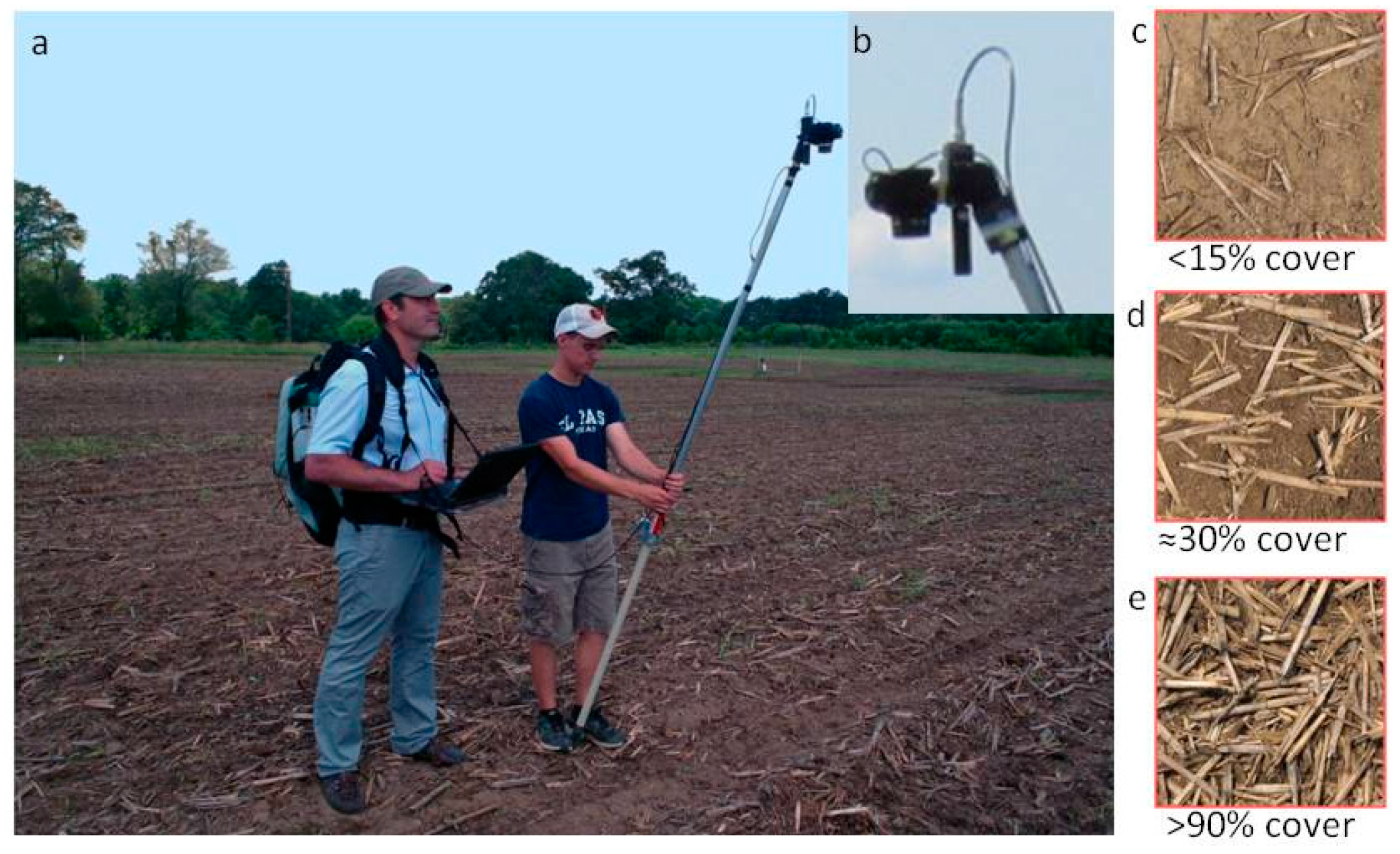
2.2. Field Experiment
2.3. Data Analysis
3. Results and Discussion
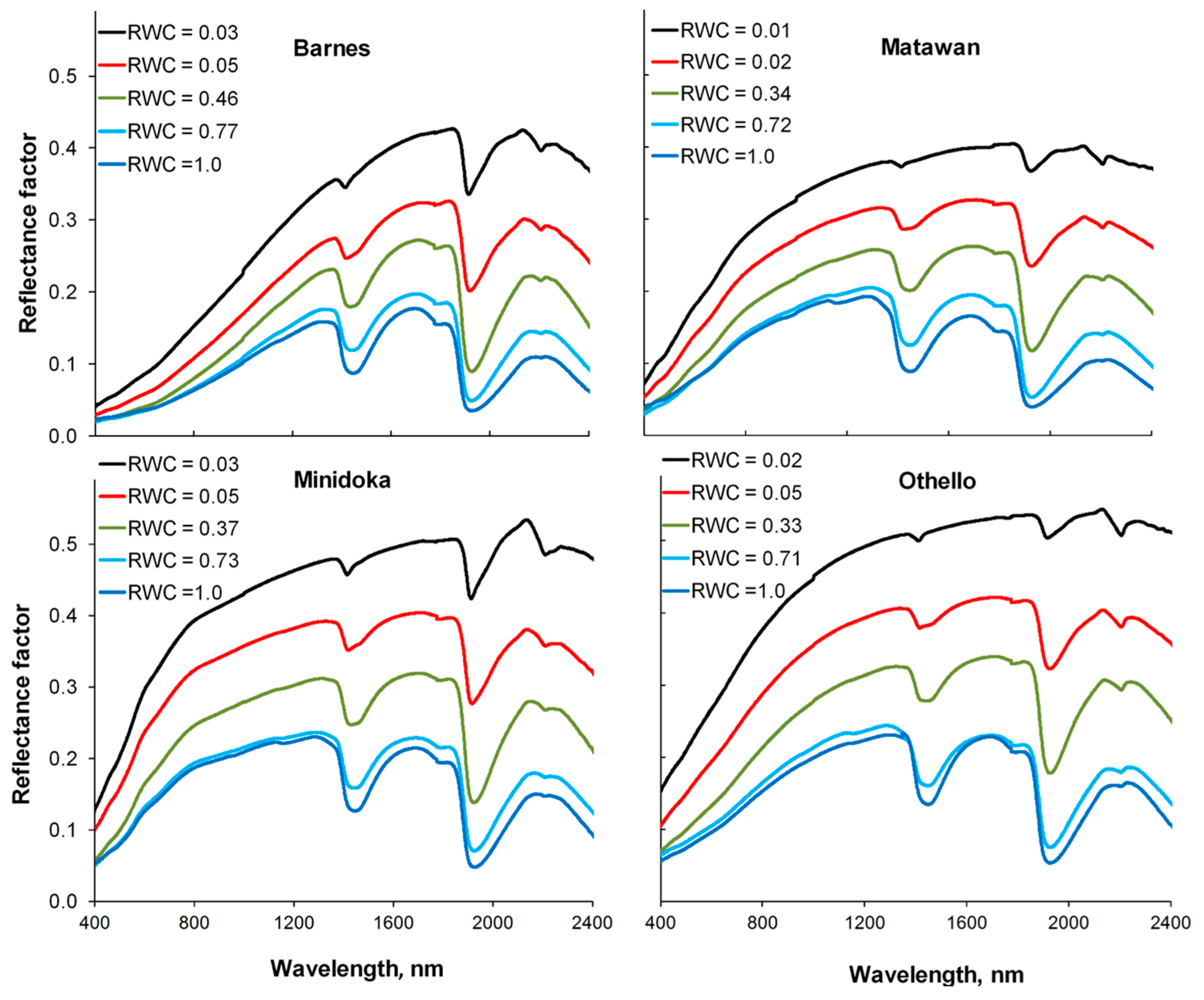
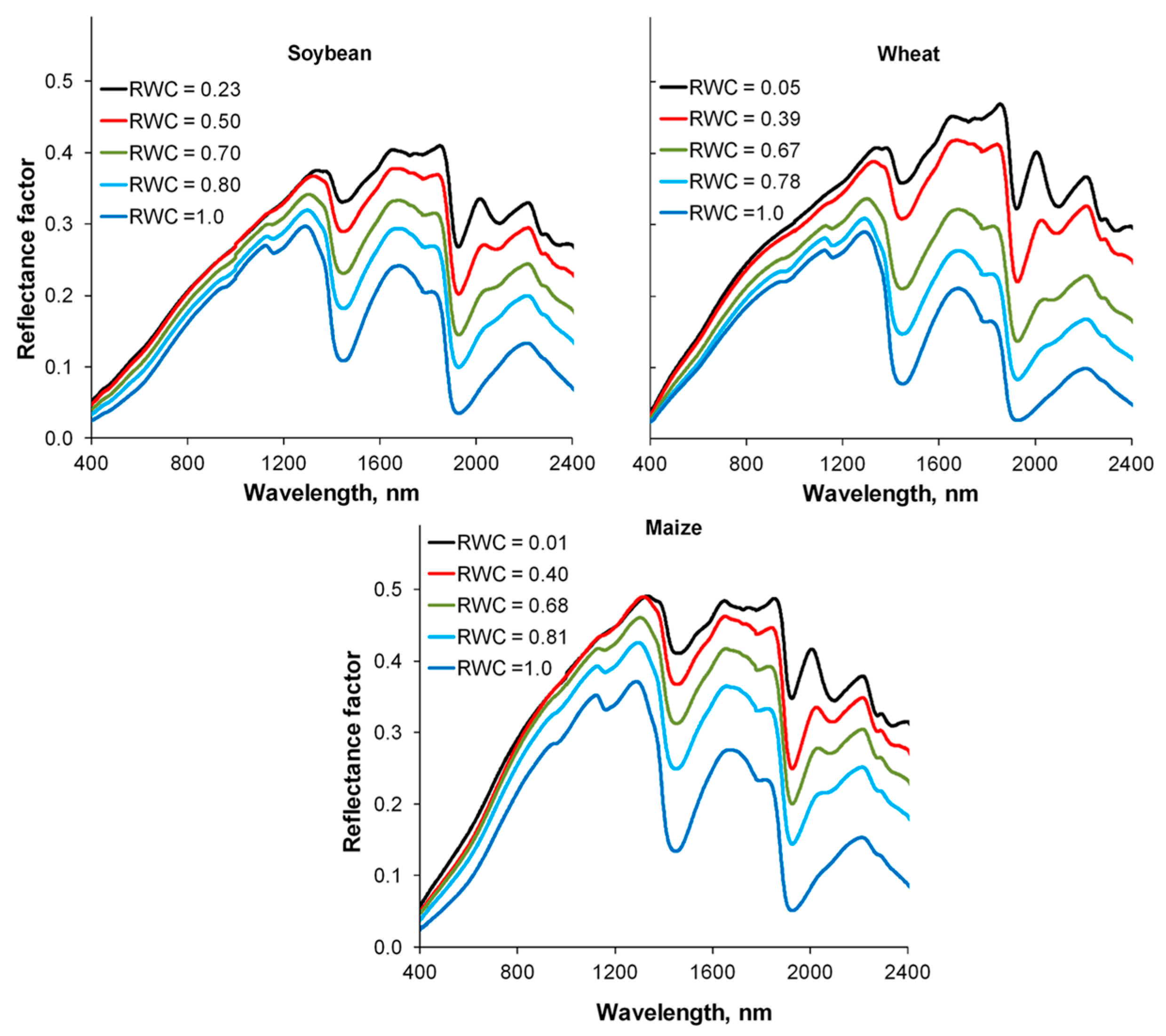
3.1. Lab Reflectance Spectra of Crop Residues and Soils
3.2. Simulated Reflectance Spectra of Mixed Scenes
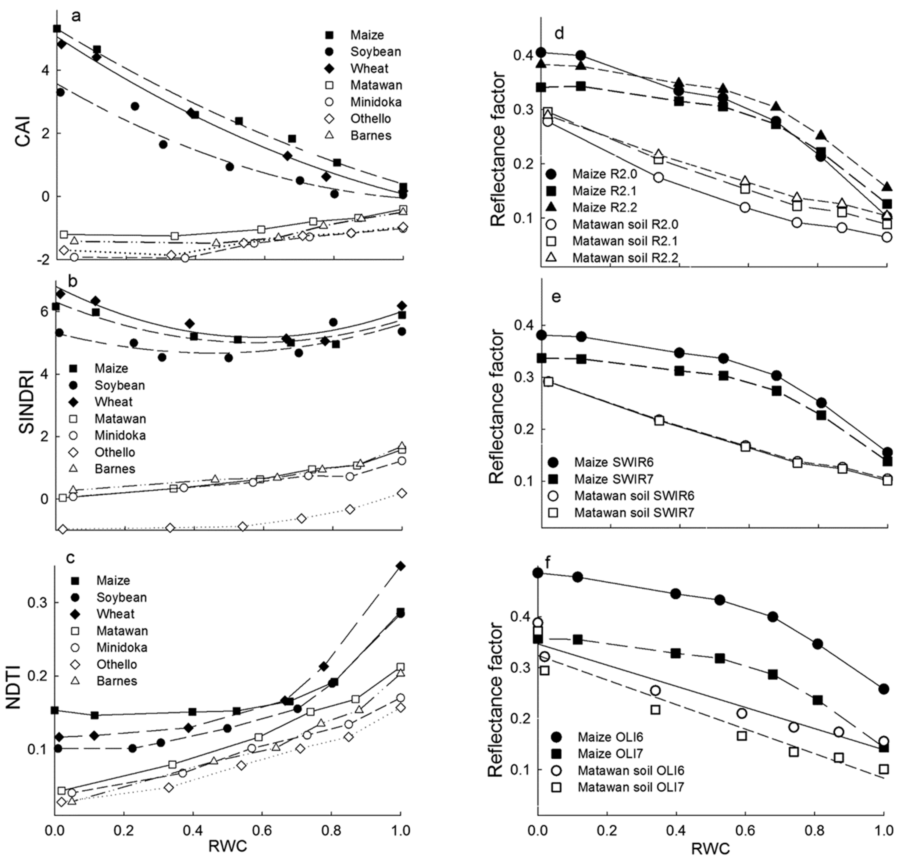
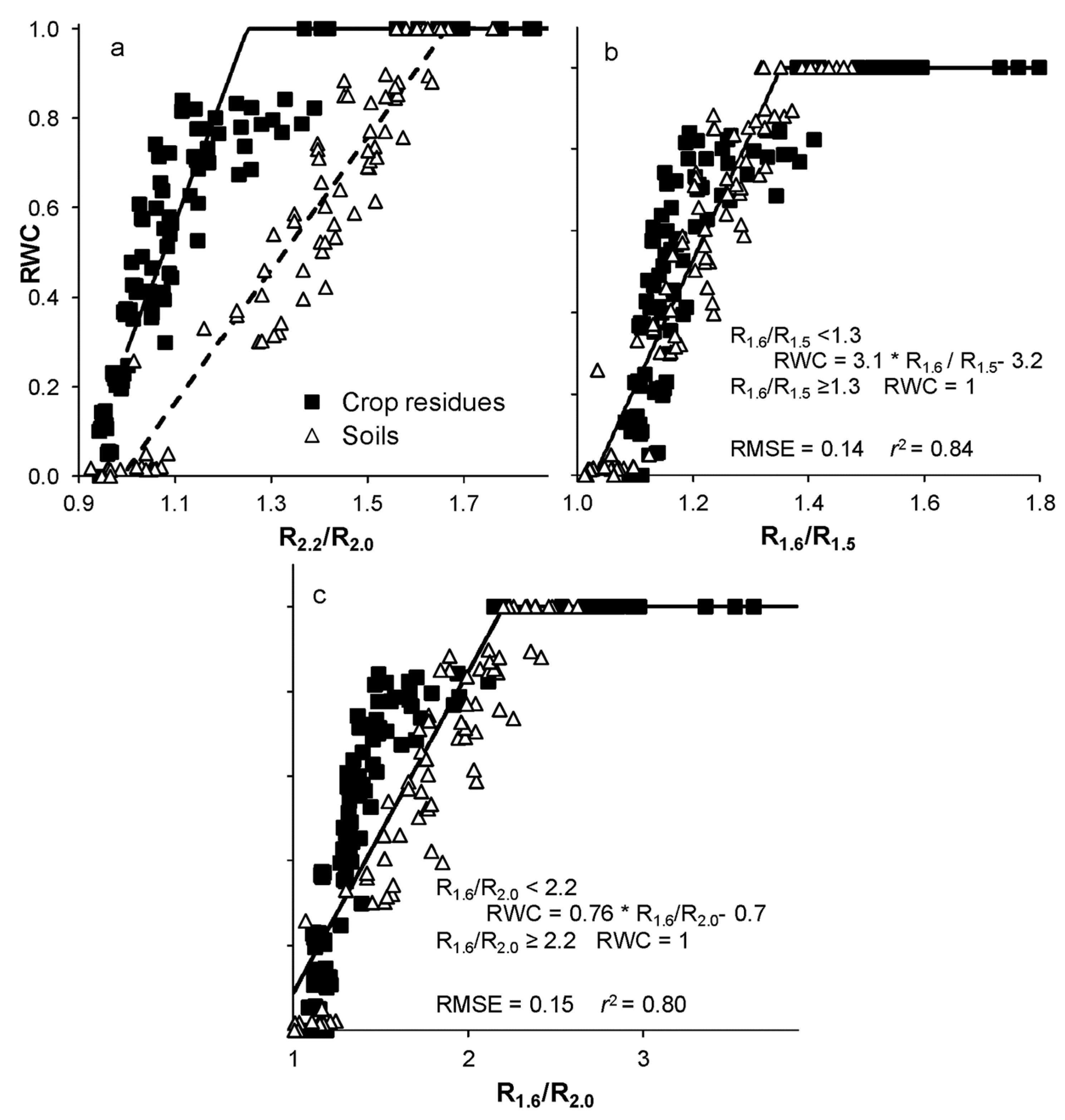
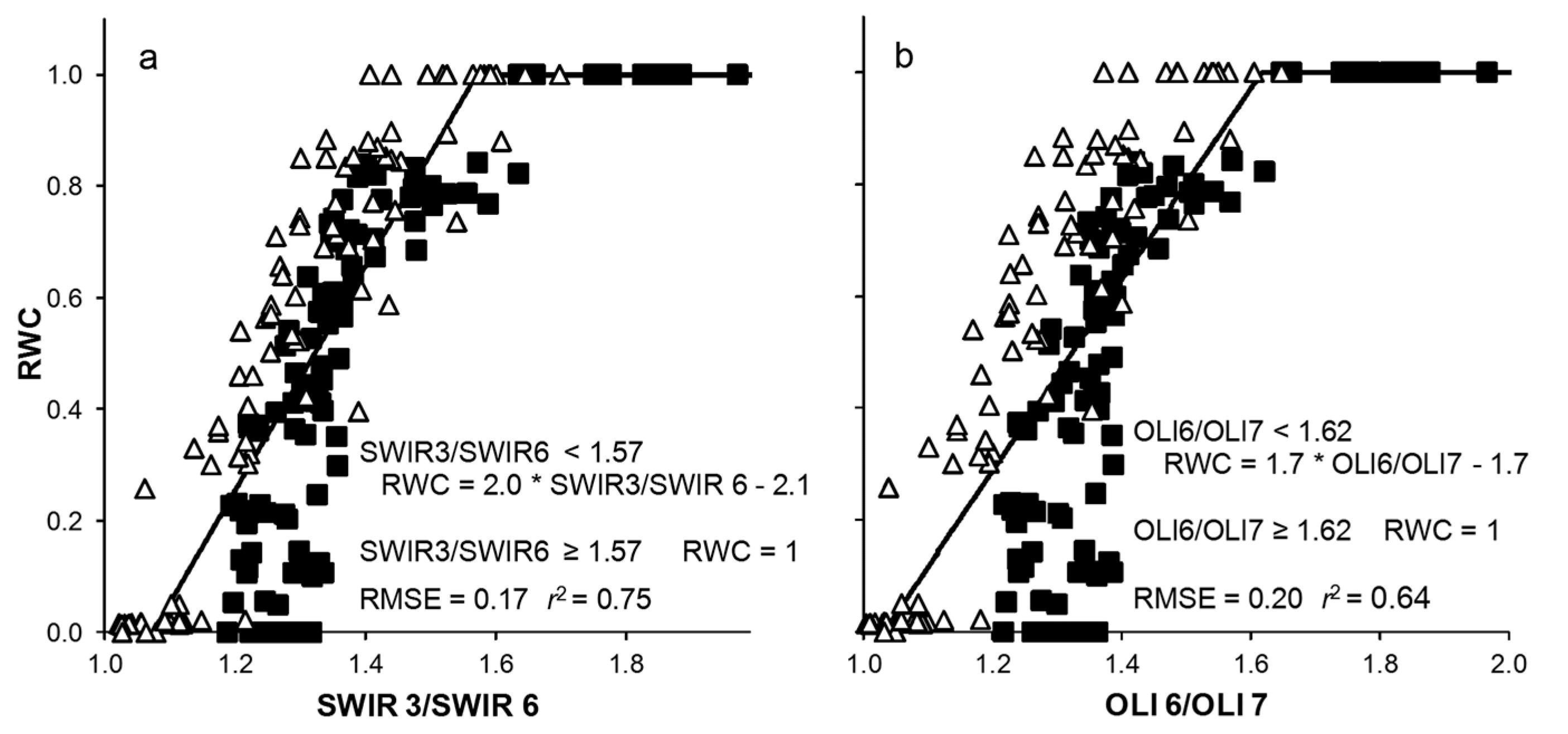
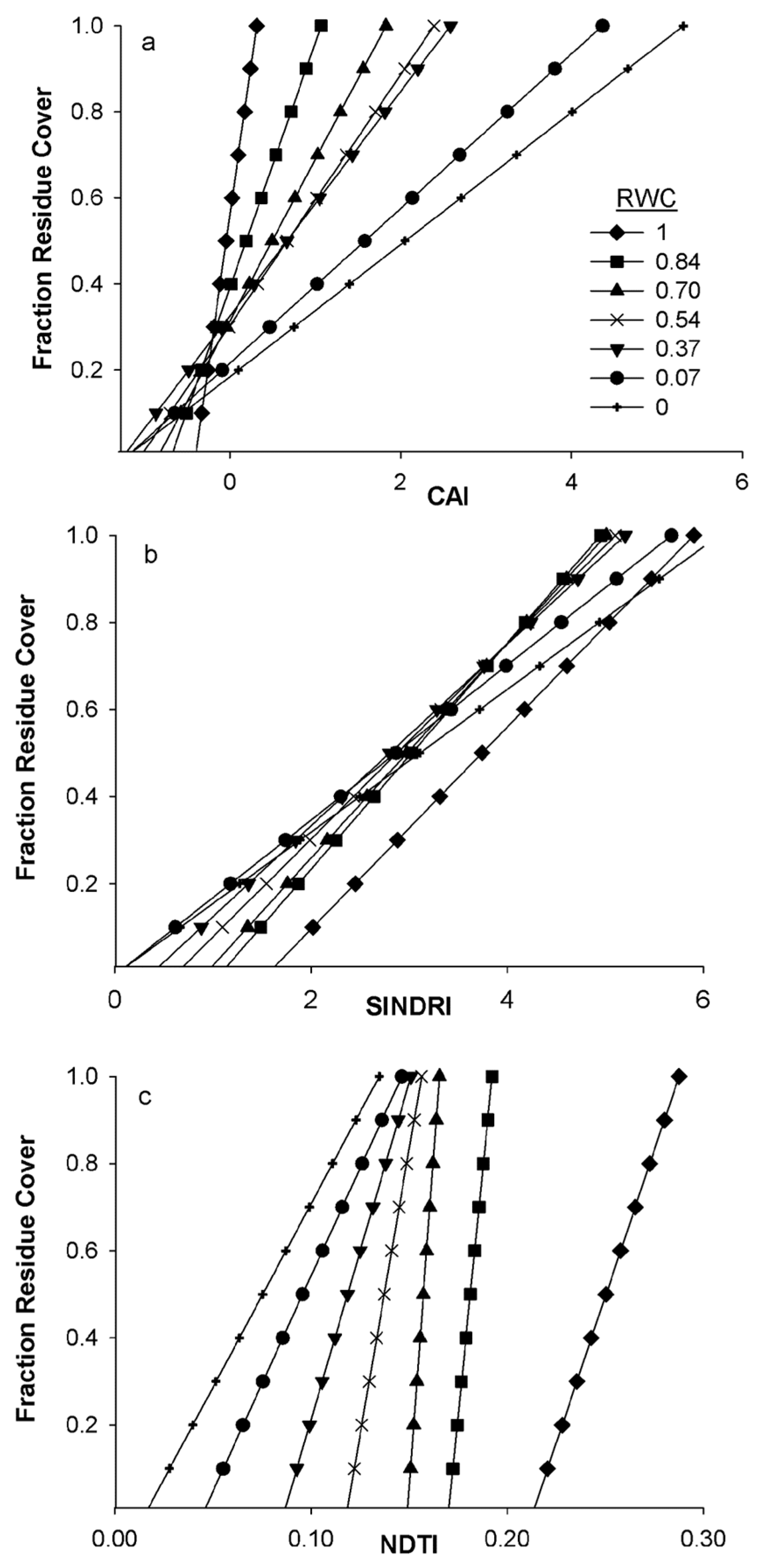
3.3. Spectral Water Indices: RWC Estimation from Lab Equations
3.4. Field Reflectance Spectra and Indices for fR Assessment
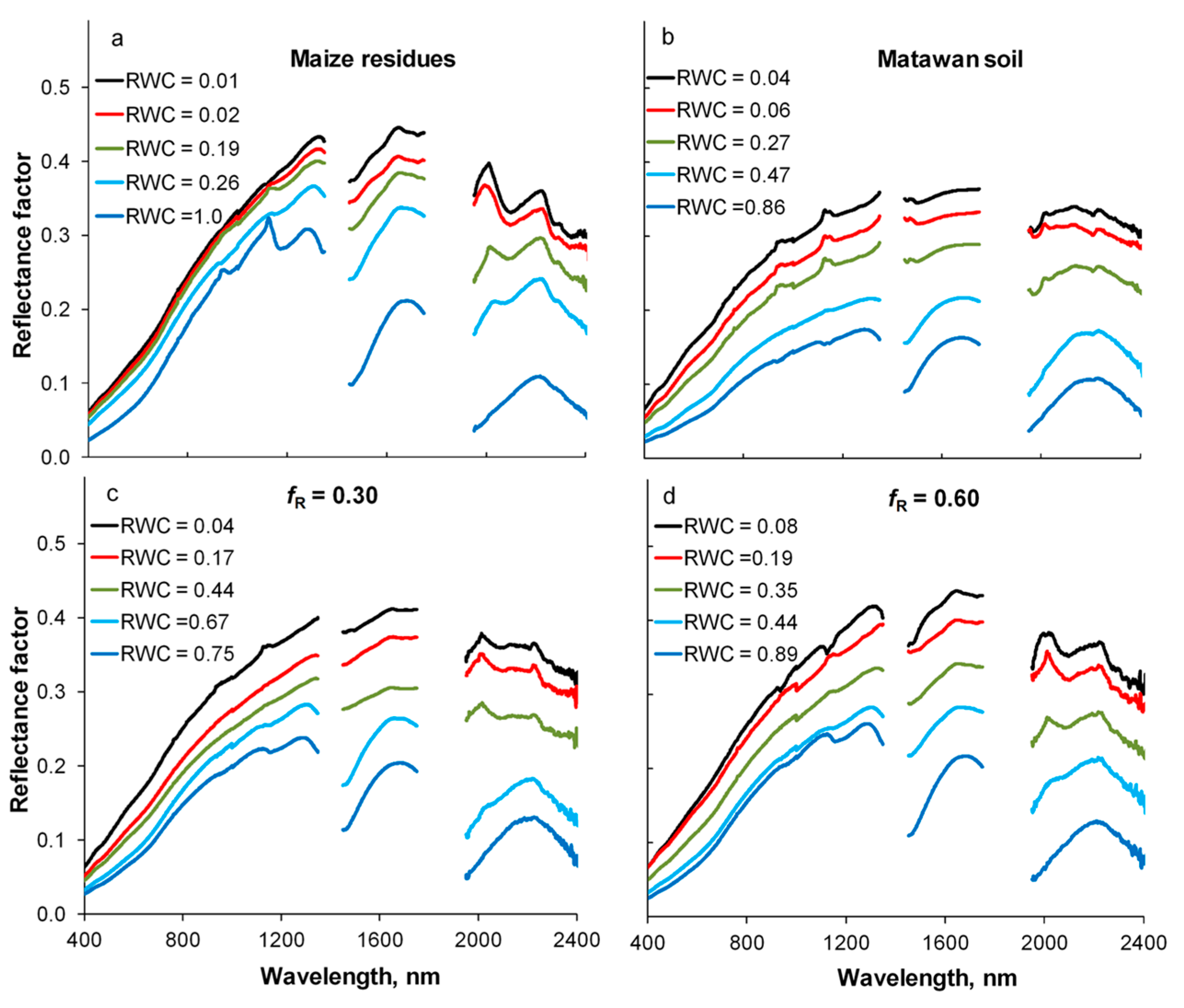
3.4.1. Reflectance Spectra
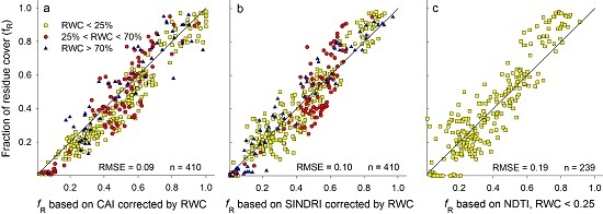
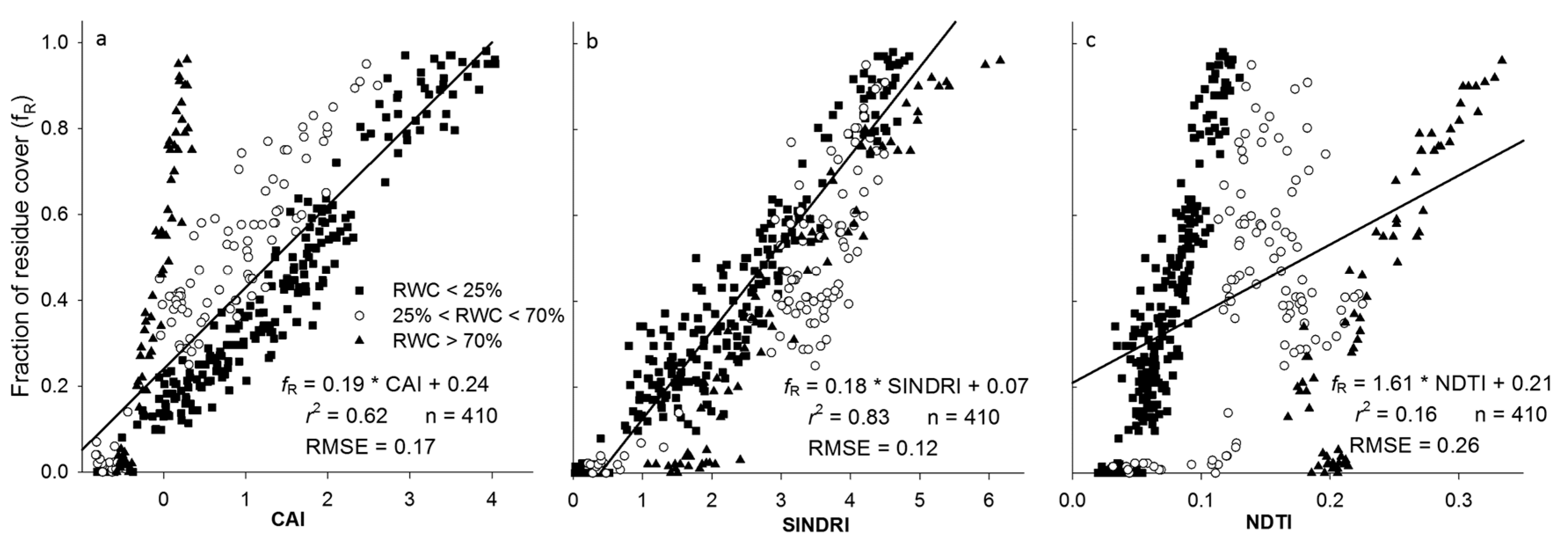
3.4.2. Relationship between fR and Spectral Indices
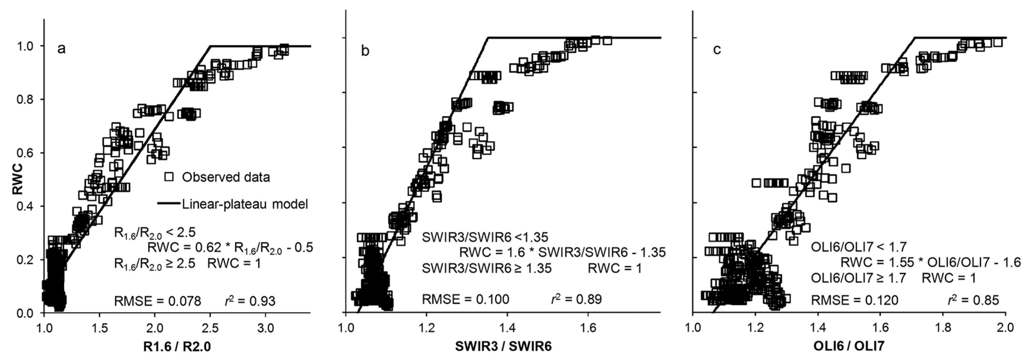
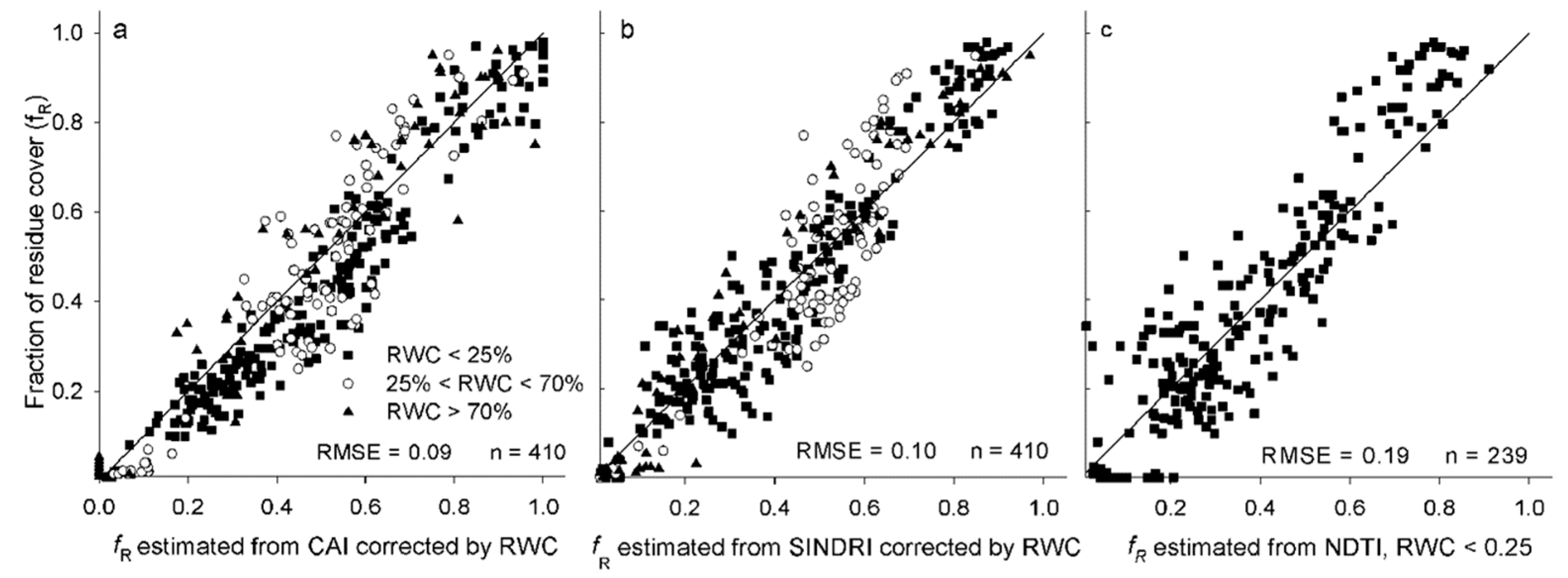
3.5. Spectral Water Indices and Prediction of fR (Residue Cover Spectral Index, Water Spectral Index)
4. General Discussion
5. Conclusions
Supplementary Materials
Acknowledgments
Author Contributions
Conflicts of Interest
References
- Delgado, J.A. Crop residue is a key for sustaining maximum food production and for conservation of our biosphere. J. Soil Water Conserv. 2010, 65, 111–116. [Google Scholar] [CrossRef]
- Lal, R.; Kimble, J.M.; Follett, R.F.; Cole, C.V. The Potential of U.S. Cropland to Sequester Carbon and Mitigate the Greenhouse Effect; Lewis Publishers: Boca Raton, FL, USA, 1999; p. 128. [Google Scholar]
- Izaurralde, R.C.; Williams, J.R.; McGill, W.B.; Rosenberg, N.J.; Quiroga Jakas, M.C. Simulating soil C dynamics with EPIC: Model description and testing against long-term data. Ecol. Model. 2006, 192, 362–384. [Google Scholar] [CrossRef]
- Gassman, P.W.; Reyes, M.; Green, C.H.; Arnold, J.G. The Soil and Water Assessment Tool: historical development, applications, and future directions. Trans. ASABE 2007, 50, 1211–1250. [Google Scholar] [CrossRef]
- CTIC Crop. Residue Management Survey System; Conservation Technology Information Center: West Lafayette, IN, USA, 2015. [Google Scholar]
- Morrison, J.E., Jr.; Huang, C.H.; Lightle, D.T.; Daughtry, C.S.T. Residue measurements techniques. J. Soil Water Conserv. 1993, 48, 479–483. [Google Scholar]
- Laflen, J.M.; Ameniya, M.; Hintz, E.A. Measuring crop residue cover. J. Soil Water Conserv. 1981, 36, 341–343. [Google Scholar]
- Corak, S.J.; Kaspar, T.C.; Meek, D.W. Evaluating methods for measuring residue cover. J. Soil Water Conserv. 1993, 48, 700–704. [Google Scholar]
- Thoma, D.P.; Gupta, S.C.; Bauer, M.E. Evaluation of optical remote sensing models for crop residue cover assessment. J. Soil Water Conserv. 2004, 59, 224–233. [Google Scholar]
- Serbin, G.; Hunt, E.R., Jr.; Daughtry, C.S.T.; Doraiswamy, P.C. An improved ASTER index for remote sensing of crop residue. Remote Sens. 2009, 1, 971–991. [Google Scholar] [CrossRef]
- Zheng, B.; Campbell, J.B.; de Beurs, K.M. Remote sensing of crop residue cover using multi-temporal Landsat imagery. Remote Sens. Environ. 2012, 117, 111–183. [Google Scholar] [CrossRef]
- Huete, A.R. Soil influences in remotely sensed vegetation-canopy spectra. In Theory and Applications of Optical Remote Sensing; Asrar, G., Ed.; John Wiley & Sons Inc.: New York, NY, USA, 1989; pp. 107–141. [Google Scholar]
- Brown, D.J.; Schepherd, K.D.; Walsh, M.G.; Mays, M.D.; Reinsch, T.G. Global soil characterization with VNIR diffuse reflectance spectroscopy. Geoderma 2006, 132, 273–290. [Google Scholar] [CrossRef]
- Daughtry, C.S.T.; Serbin, G.; Reeves, J.B.; Doraiswamy, P.C.; Hunt, E.R., Jr. Spectral reflectance of wheat residue during decomposition and remotely sensed estimates of residue cover. Remote Sens. 2010, 2, 416–431. [Google Scholar] [CrossRef]
- Nagler, P.L.; Daughtry, C.S.T.; Goward, S.N. Plant litter and soil reflectance. Remote Sens. Environ. 2000, 71, 207–215. [Google Scholar] [CrossRef]
- Wang, C.K.; Pan, X.Z.; Liu, Y.; Li, Y.L.; Shi, R.; Zhou, R.; Xie, X.L. Alleviating moisture effects on remote Sensing estimation of crop residue cover. Agron. J. 2013, 105, 967–976. [Google Scholar] [CrossRef]
- Kokaly, R.F.; Clark, R.N. Spectroscopic determination of leaf biochemistry using band-depth analysis of absorption features and stepwise multiple linear regression. Remote Sens. Environ. 1999, 67, 267–287. [Google Scholar] [CrossRef]
- Curran, P.J. Remote sensing of foliar chemistry. Remote Sens. Environ. 1999, 30, 271–278. [Google Scholar] [CrossRef]
- Daughtry, C.S.T.; Hunt, E.R., Jr.; Doraiswamy, P.C.; McMurtrey, J.E., III. Remote sensing the spatial distribution of crop residues. Agron. J. 2005, 97, 864–871. [Google Scholar] [CrossRef]
- Daughtry, C.S.T.; Hunt, E.R., Jr. Mitigating the effects of soil and residue water contents on remotely sensed estimates of crop residue cover. Remote Sens. Environ. 2008, 112, 1647–1657. [Google Scholar] [CrossRef]
- USGS. Earth Observing 1 (EO-1): Sensors—Hyperion. Available online: http://eo1.usgs.gov/hyperion.php (accessed on 9 June 2016).
- EnMap. EnMap Hyperspectral Imager. Available online: http://www.enmap.org/ (accessed on 9 June 2016).
- Daughtry, C.S.T. Discriminating crop residues from soil by shortwave infrared reflectance. Agron. J. 2001, 93, 125–131. [Google Scholar] [CrossRef]
- Goward, S.N.; Arvindson, T.; Williams, D.L.; Irish, R.; Irons, J.R. Moderate Spatial Resolution Optical Sensors. In The Sage Handbook of Remote Sensing; Warner, T.A., Ed.; Sage Publications: Thousand Oaks, CA, USA, 2009; pp. 123–138. [Google Scholar]
- SIC. Satellite Imaging Corporation. Available online: http://www.satimagingcorp.com/satellite-sensors/worldview-3/ (accessed on 9 June 2016).
- Abrams, M. The Advanced Spaceborne Thermal Emission and Reflection Radiometer (ASTER): Data products for the high spatial resolution imager on NASA’s Terra platform. Int. J. Remote Sens. 2000, 21, 847–859. [Google Scholar] [CrossRef]
- Bannari, A.; Pacheco, A.; Staenz, K.; McNairn, H.; Omari, K. Estimating and Mapping Crop Residue Cover in Agricultural Lands Using Hyperspectral and IKONOS data. Remote Sens. Environ. 2006, 104, 447–459. [Google Scholar] [CrossRef]
- Zheng, B.; Campbell, J.; Serbin, G.; Daughtry, C.S.T. Multi-temporal remote sensing of crop residue cover and tillage practices: A validation of the minNDTI strategy in the United States. J. Soil Water Conserv. 2013, 68, 120–131. [Google Scholar] [CrossRef]
- NASA. International Space Station. Available online: http://www.nasa.gov/mission_pages/landsat/main (accessed on 9 June 2016).
- European Space Agency. Available online: http://www.esa.int/Our_Activities/Observing_the_Earth/Copernicus/Sentinel-2 (accessed on 9 June 2016).
- McNairn, H.; Protz, R. Mapping corn residue cover on agricultural fields in Oxford County, Ontario using Thematic Mapper. Can. J. Remote Sens. 1993, 19, 152–158. [Google Scholar] [CrossRef]
- Van Deventer, A.P.; Ward, A.D.; Gowda, P.H.; Lyon, J.G. Using Thematic Mapper Data to Identify Contrasting Soil Plains and Tillage Practices. Photogramm. Eng. Remote Sens. 1997, 63, 87–93. [Google Scholar]
- Hunt, E.R.; Rock, B.N. Detection of changes in leaf water content using near- and middle-infrared reflectances. Remote Sens. Environ. 1989, 30, 43–54. [Google Scholar]
- Hunt, E.R., Jr.; Daughtry, C.S.T.; Li, L. Feasibility of estimating leaf water content using spectral indices from WolrdView-3’s near-infrared and shortwave infrared bands. Int. J. Remote Sens. 2016, 37, 388–402. [Google Scholar] [CrossRef]
- Lobell, D.; Asner, G.P. Moisture effects on soil reflectance. Soil Sci. Soc. Am. J. 2002, 66, 722–727. [Google Scholar] [CrossRef]
- Hardisky, M.A.; Klemas, V.; Smart, R.M. The influence of soil-salinity, growth form, and leaf moisture on the spectral radiance of Spartina alterniflora canopies. Photogramm. Eng. Remote Sens. 1983, 49, 77–83. [Google Scholar]
- Gao, Y.; Walker, J.P.; Allahmoradi, M.; Monerris, A.; Ryu, D.; Thomas, J.J. Optical sensing of vegetation water content: A synthesis study. IEEE J. Sel. Top. Appl. 2015, 8, 1456–1464. [Google Scholar]
- Pyne, S.J.; Andrews, P.L.; Laven, R.D. Introduction to Wildland Fire; John Wiley & Son Publishing: New York, NY, USA, 1996; p. 769. [Google Scholar]
- Robinson, B.F.; Biehl, L.L. Calibration procedures for measurement of reflectance factor in remote sensing field research. Soc. Photo-Opt. Instrum. 1979, 196, 16–26. [Google Scholar]
- Gish, T.J.; Walthall, C.L.; Daughtry, C.S.T.; Kung, K.-J.S. Using soil moisture and spatial yield patterns to identify subsurface flow pathways. J. Environ. Qual. 2005, 34, 274–286. [Google Scholar] [CrossRef] [PubMed]
- Booth, D.T.; Cox, S.E.; Berryman, R.D. Precision measurements from very-large scale aerial digital imagery. Environ. Monit. Assess. 2006, 112, 293–307. [Google Scholar] [CrossRef] [PubMed]
- Liaw, A.; Wiener, M. Classification and regression by random forest. R. News 2002, 2, 18–22. [Google Scholar]
- Murray, I.; Williams, P.C. Chemical Principles of Near-Infrared Technology. In Near-Infrared Technology in the Agricultural and Food Industries; Williams, P.C., Norris, K., Eds.; American Association Cereal Chemists: St. Paul, MN, USA, 1988. [Google Scholar]
- Whiting, M.L.; Li, L.; Ustin, S. Predicting water content using Gaussian model on soil spectra. Remote Sens. Environ. 2004, 89, 535–552. [Google Scholar] [CrossRef]
- Dematte, J.A.M.; Soussa, A.A.; Alves, M.C.; Nanni, M.R.; Fiorio, P.R.; Campos, R.C. Determining soil water status and other soil characteristics by spectral proximal sensing. Geoderma 2006, 135, 179–195. [Google Scholar] [CrossRef]
- Daughtry, C.S.T.; Doraiswamy, P.C.; Hunt, E.R.; Stern, A.J.; McMurtrey, J.E., III; Prueger, J.H. Remote sensing of crop residue cover and soil tillage intensity. Soil Tillage Res. 2006, 91, 101–108. [Google Scholar] [CrossRef]
- Galloza, M.S.; Crawford, M.M.; Heathman, G.C. Crop residue modeling and mapping using Landsat, ALI, Hyperion, airborne remote sensing data. IEEE J. Sel. Top. Appl. 2013, 6, 446–456. [Google Scholar] [CrossRef]
- Sullivan, D.G.; Strickland, T.C.; Masters, M.H. Satellite mapping of conservation tillage adoption in the Little River experimental watershed, Georgia. J. Soil Water Conserv. 2008, 63, 112–119. [Google Scholar] [CrossRef]
- Gelder, B.K.; Kaleita, A.L.; Cruse, R.M. Estimating Mean Field Residue Cover on Midwestern Soils Using Satellite Imagery. Agron. J. 2009, 101, 635–643. [Google Scholar] [CrossRef]
- Quemada, M.; Cabrera, M.L. Characteristic moisture curves and maximum water content of two crop residues. Plant. Soil 2002, 238, 295–299. [Google Scholar] [CrossRef]
- Quemada, M.; Cabrera, M.L. Predicting crop residue decomposition using moisture adjusted time scales. Nutr. Cycl. Agroecosyst. 2004, 70, 283–291. [Google Scholar] [CrossRef]
- Guerschman, J.P.; Hill, M.J.; Renzullo, L.J.; Barrett, D.J.; Marks, A.S.; Botha, E.J. Estimating fractional cover of photosynthetic vegetation, non-photosynthetic vegetation and bare soil in the Australian tropical savanna region upscaling the EO-1 Hyperion and MODIS sensors. Remote Sens. Environ. 2009, 113, 928–945. [Google Scholar] [CrossRef]
- Gao, F.; Masek, J.G.; Hall, J.; Schwaller, M. On the blending of the Landsat and MODIS surface reflectance: predicting daily Landsat surface reflectance. IEEE Trans. Geosci. Remote 2006, 44, 2207–2218. [Google Scholar]
- Gao, F.; Masek, J.; Wolfe, R.; Huang, C. Building consistent medium resolution satellite data set using moderate resolution imaging spectroradiometer products as reference. J. Appl. Remote Sens. 2010, 4, 043526. [Google Scholar]


| Soil Series | Class | Munsell Color | Texture | Location | |
|---|---|---|---|---|---|
| Dry | Moist | ||||
| Barnes | Fine-loamy, mixed, superactive, frigid Calcic Hapludolls | 10YR * 4/1 | 10YR 2/1 | Loam | Morris, MN, USA |
| Minidoka | Coarse-silty, mixed, superactive, mesic Xeric Haplodurids | 10YR 6/3 | 10YR 4/3 | Silt loam | Minidoka, MN, USA |
| Othello | Fine-silty, mixed, active, mesic Typic Endoaquults | 10YR 6/1 | 10YR 4/1 | Silt loam | Salisbury, MD, USA |
| Matawan | Fine-loamy, siliceous, semi-active, mesic Aquic Hapludults | 10YR 6/2 | 10YR 3/2 | Sandy loam | Beltsville, MD, USA |
| Band * | Wavelengths, nm | Residue Index | Equation | Reference |
|---|---|---|---|---|
| R2.0 | 2025–2035 | Cellulose Absorption Index (CAI) | (1) | [24] |
| R2.1 | 2095–2105 | |||
| R2.2 | 2200–2210 | |||
| SWIR6 | 2185–2225 | Shortwave Infrared Normalized Difference Residue Index (SINDRI) | (2) | [10] |
| SWIR7 | 2235–2285 | |||
| OLI6 | 1570–1650 | Normalized Difference Tillage Index (NDTI) | (3) | [32] |
| OLI7 | 2110–2290 |
| Equation | Reference | RMSE | Comments |
|---|---|---|---|
| R1.65/R0.85 | [33] | 0.40 | Rx.x reflectance in the hyperspectral 10-nm bands centered at the wavelengths designated by the sub-index in µm |
| (R0.85 − R1.65)/(R0.85 + R1.65) | [36] | 0.31 | |
| R1.6/R1.5 | This study | 0.14 | |
| R1.6/R2.0 | This study | 0.15 | |
| R2.2/R2.0 | [21] | 0.19 | |
| SWIR3/SWIR5 | This study | 0.18 | Reflectance in the WorldView, 3 bands |
| SWIR3/SWIR6 | This study | 0.17 | SWIR3: 1640–1680 nm SWIR5: 2145–2185 nm SWIR6: 2185–2225 nm |
| OLI5/OLI7 | [37] | 0.20 | Reflectance in the Landsat OLI bands |
| OLI6/OLI7 | [37] | 0.19 | OLI5:850–880 nm OLI6: 1570–1650 nm OLI7: 2110–2290 nm |
| (OLI5 − OLI6)/(OLI5 + OLI6) | [38] | 0.26 | |
| (OLI5 − OLI7)/(OLI5 + OLI7) | [37] | 0.20 |
| Model | Residue | fR Versus Index | RMSE | Adj. r2 | |||
|---|---|---|---|---|---|---|---|
| a ± SE | b ± SE | c ± SE | d ± SE | ||||
| Cellulose Adsorption Index (CAI) | |||||||
| Slope = a + b × exp (c × RWC) | Maize | 0.21 ± 0.29 | 0.001 ± 0.010 | 8.15 ± 1.08 | - | 0.055 | 0.98 |
| Soybean | 0.18 ± 0.02 | 0.008 ± 0.002 | 5.52 ± 0.24 | - | 0.030 | 0.99 | |
| Wheat | 0.14 ± 0.02 | 0.018 ± 0.004 | 4.47 ± 0.20 | - | 0.024 | 0.99 | |
| Intercept = a + b × exp (c × RWC) | Maize | 0.20 ± 0.02 | 0.009 ± 0.008 | 3.67 ± 0.92 | - | 0.028 | 0.95 |
| Soybean | 0.20 ± 0.03 | 0.029 ± 0.013 | 3.11 ± 0.41 | - | 0.025 | 0.98 | |
| Wheat | 0.26 ± 0.02 | 0.101 ± 0.005 | 4.09 ± 0.48 | - | 0.023 | 0.99 | |
| Shortwave Infrared Normalized Difference Residue Index (SINDRI) | |||||||
| RWC < d Slope = (a × (d − RWC) + b × (RWC − RWCmin))/(d − RWCmin) RWC > d Slope = (b × (RWCmax − RWC) + c × (RWC − d))/(RWCmax − d) | Maize | 0.17 ± 0.01 | 0.267 ± 0.028 | 0.23 ± 0.01 | 0.88 ± 0.26 | 0.006 | 0.97 |
| Soybean | 0.18 ± 0.01 | 0.286 ± 0.009 | 0.25 ± 0.01 | 0.76 ± 0.06 | 0.013 | 0.88 | |
| Wheat | 0.15 ± 0.02 | 0.254 ± 0.679 | 0.22 ± 0.01 | 0.78 ± 0.69 | 0.004 | 0.99 | |
| Intercept = a + b × RWC | Maize | 0.01 ± 0.02 | −0.348 ± 0.026 | - | - | 0.025 | 0.97 |
| Soybean | 0.01 ± 0.02 | −0.367 ± 0.031 | - | - | 0.024 | 0.97 | |
| Wheat | 0.01 ± 0.01 | −0.358 ± 0.006 | - | - | 0.005 | 0.99 | |
| Normalized Difference Tillage Index (NDTI) | |||||||
| Slope = a + b × exp (−0.5 × ((RWC − c)/d)2) | Maize | 10.6 ± 2.2 | 52.8 ± 4.1 | 0.74 ± 0.01 | 0.12 ± 0.01 | 3.772 | 0.97 |
| Soybean | 11.9 ± 5.9 | 90.9 ± 11.1 | 0.57 ± 0.02 | 0.14 ± 0.02 | 8.704 | 0.92 | |
| Wheat | 6.8 ± 0.8 | 100.1 ± 1.4 | 0.48 ± 0.01 | 0.16 ± 0.94 | 0.936 | 0.99 | |
| Intercept = a + b × exp (−0.5 × ((RWC − c)/d)2) | Maize | −0.59 ± 0.28 | −9.1 ± 0.5 | 0.77 ± 0.01 | 0.14 ± 0.01 | 0.476 | 0.98 |
| Soybean | −0.20 ± 1.71 | −11.7 ± 2.1 | 0.61 ± 0.03 | 0.18 ± 0.05 | 1.888 | 0.86 | |
| Wheat | −0.77 ± 0.64 | −13.6 ± 1.4 | 0.51 ± 0.00 | 0.15 ± 0.02 | 0.782 | 0.96 | |
| Slope | Intercept | Adj. r2 | n | |
|---|---|---|---|---|
| Cellulose Absorption Index (CAI) | ||||
| RWC < 0.25 | 0.22 | 0.13 | 0.95 ** | 240 |
| 0.25 < RWC < 0.70 | 0.27 | 0.26 | 0.88 ** | 100 |
| RWC > 0.70 | 1.13 | 0.56 | 0.93 ** | 70 |
| Shortwave Infrared Normalized Difference Residue Index (SINDRI) | ||||
| RWC < 0.25 | 0.20 | −0.05 | 0.91 ** | 240 |
| 0.25 < RWC < 0.70 | 0.17 | −0.07 | 0.76 * | 100 |
| RWC > 0.70 | 0.23 | −0.32 | 0.94 ** | 70 |
| Normalized Difference Tillage Index (NDTI) | ||||
| RWC < 0.25 | 10.13 | −0.34 | 0.85 ** | 240 |
| 0.25 < RWC < 0.70 | 6.74 | −0.31 | 0.22 | 100 |
| RWC > 0.70 | 6.35 | −1.09 | 0.83 ** | 70 |
| RMSE | Adj. r2 | |
|---|---|---|
| Water indices based on narrow bands | ||
| R2.2/R2.0 | 0.100 | 0.93 |
| R1.6/R1.5 | 0.099 | 0.93 |
| R1.6/R2.0 | 0.096 | 0.94 |
| Water indices based on satellite bands | ||
| SWIR 3/SWIR 6 | 0.151 | 0.88 |
| OLI6 /OLI7 | 0.177 | 0.84 |
| Spectral Water Index | Linear-Plateau Model † | ||||
|---|---|---|---|---|---|
| a | b | c | RMSE | Adj. r2 | |
| Water indices based on narrow bands | |||||
| R2.2/R2.0 | −1.1 | 1.23 | 1.66 | 0.081 | 0.92 |
| R1.6/R1.5 | −2.6 | 2.57 | 1.41 | 0.083 | 0.93 |
| R1.6/R2.0 | −0.5 | 0.62 | 2.50 | 0.078 | 0.93 |
| Water indices based on satellite bands | |||||
| SWIR 3/SWIR 6 | −1.7 | 1.60 | 1.69 | 0.100 | 0.89 |
| OLI6 /OLI7 | −1.6 | 1.55 | 1.71 | 0.120 | 0.85 |
| R2.2/R2.0 | R1.6/R1.5 | R1.6/R2.0 | SWIR3/SWIR6 | OLI6/OLI7 | Without RWC Correction | n | |
|---|---|---|---|---|---|---|---|
| CAI | 0.10 | 0.09 | 0.10 | 0.11 | 0.12 | 0.17 | 410 |
| SINDRI | 0.11 | 0.10 | 0.10 | 0.10 | 0.11 | 0.12 | 410 |
| NDTIall values | 0.31 | 0.31 | 0.32 | 0.34 | 0.34 | 0.26 | 410 |
| NDTIRWC<0.50 | 0.21 | 0.21 | 0.22 | 0.24 | 0.25 | 0.25 | 305 |
| NDTIRWC<0.25 | 0.18 | 0.18 | 0.19 | 0.19 | 0.19 | 0.21 | 239 |
© 2016 by the authors; licensee MDPI, Basel, Switzerland. This article is an open access article distributed under the terms and conditions of the Creative Commons Attribution (CC-BY) license (http://creativecommons.org/licenses/by/4.0/).
Share and Cite
Quemada, M.; Daughtry, C.S.T. Spectral Indices to Improve Crop Residue Cover Estimation under Varying Moisture Conditions. Remote Sens. 2016, 8, 660. https://doi.org/10.3390/rs8080660
Quemada M, Daughtry CST. Spectral Indices to Improve Crop Residue Cover Estimation under Varying Moisture Conditions. Remote Sensing. 2016; 8(8):660. https://doi.org/10.3390/rs8080660
Chicago/Turabian StyleQuemada, Miguel, and Craig S. T. Daughtry. 2016. "Spectral Indices to Improve Crop Residue Cover Estimation under Varying Moisture Conditions" Remote Sensing 8, no. 8: 660. https://doi.org/10.3390/rs8080660
APA StyleQuemada, M., & Daughtry, C. S. T. (2016). Spectral Indices to Improve Crop Residue Cover Estimation under Varying Moisture Conditions. Remote Sensing, 8(8), 660. https://doi.org/10.3390/rs8080660