Mapping Dynamics of Inundation Patterns of Two Largest River-Connected Lakes in China: A Comparative Study
Abstract
:1. Introduction
2. Study Area and Data Used
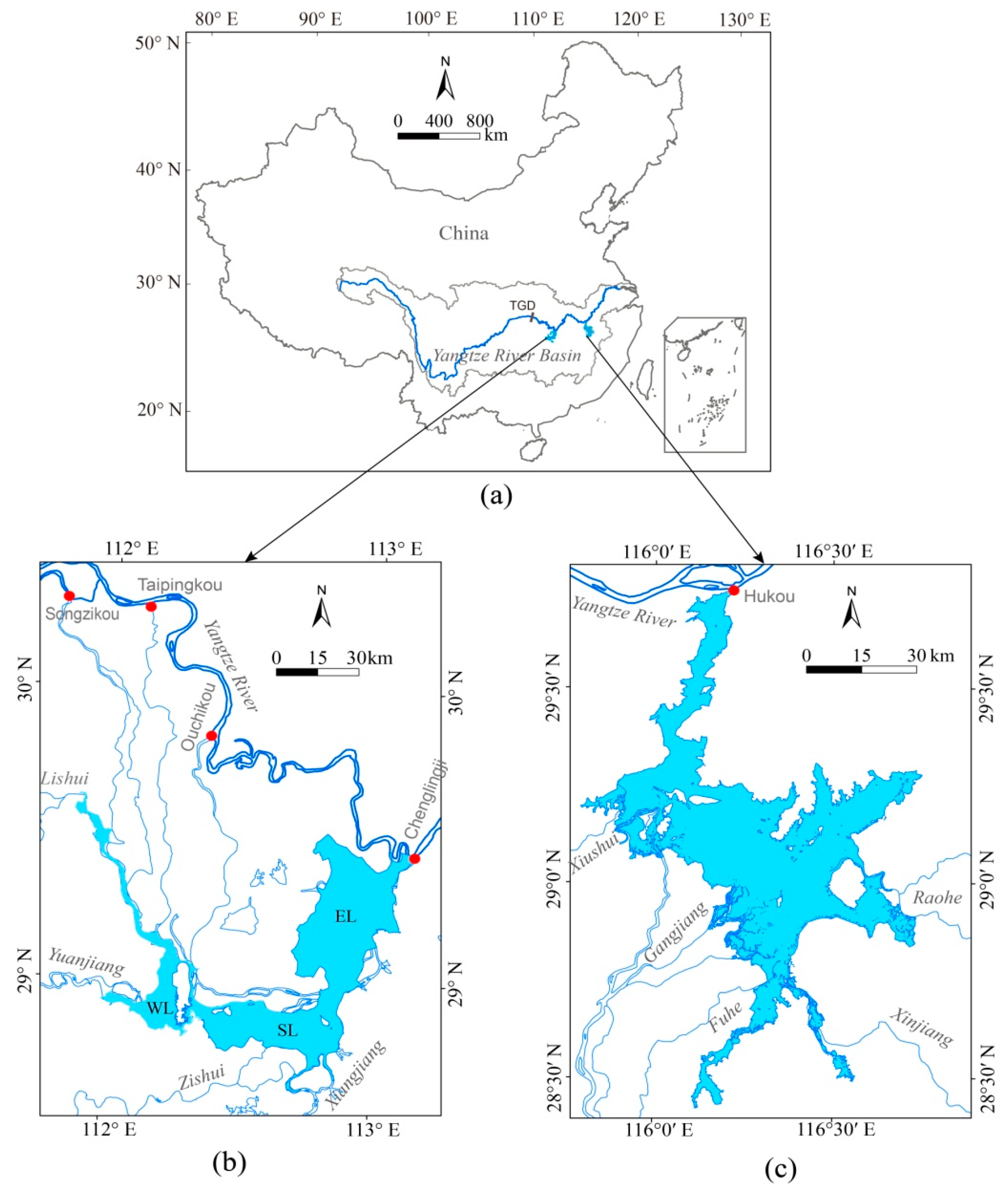
2.1. Study Area
- (1)
- Poyang Lake:
- (2)
- Dongting Lake:
2.2. Data Acquisition and Pre-Processing
3. Methodology
4. Results
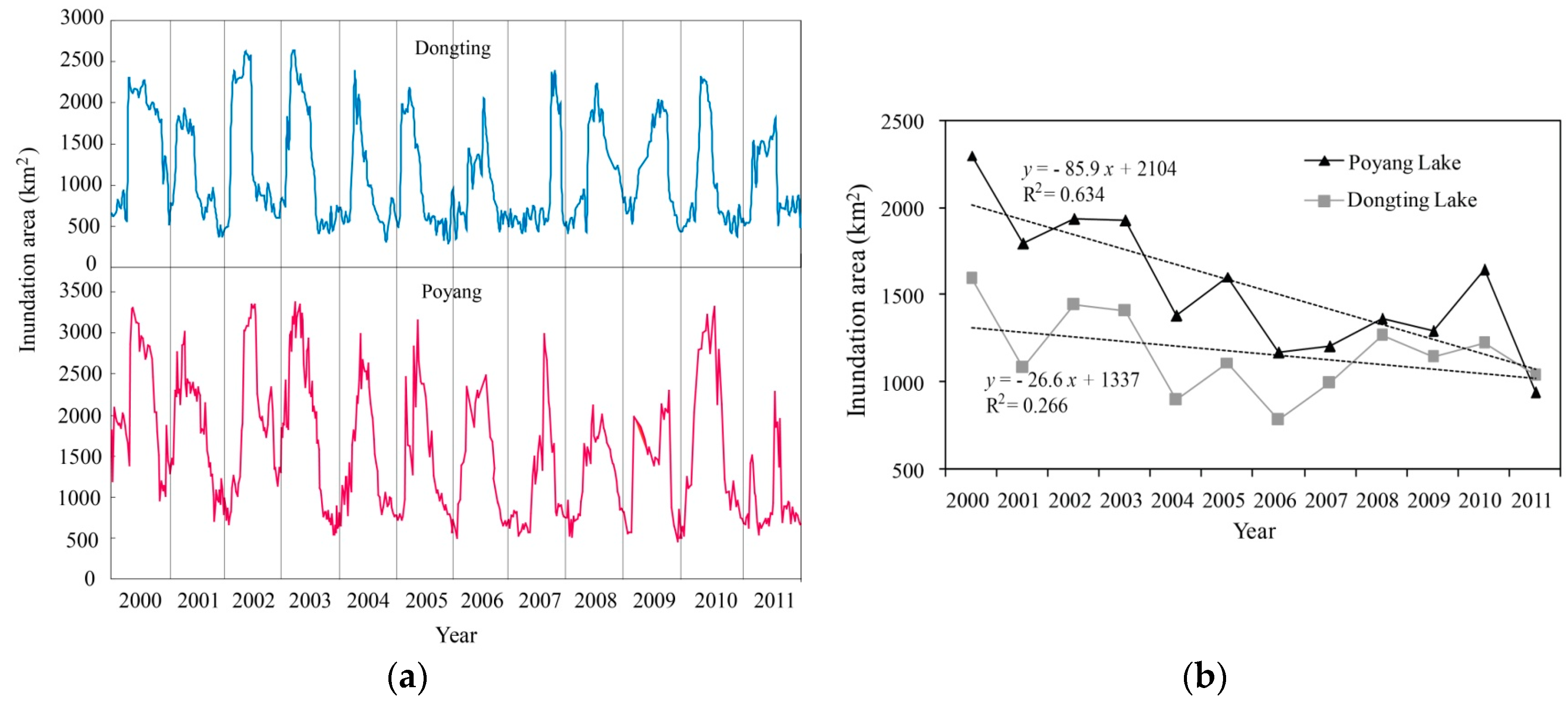
4.1. Temporal Dynamics of the Lake Inundation Area
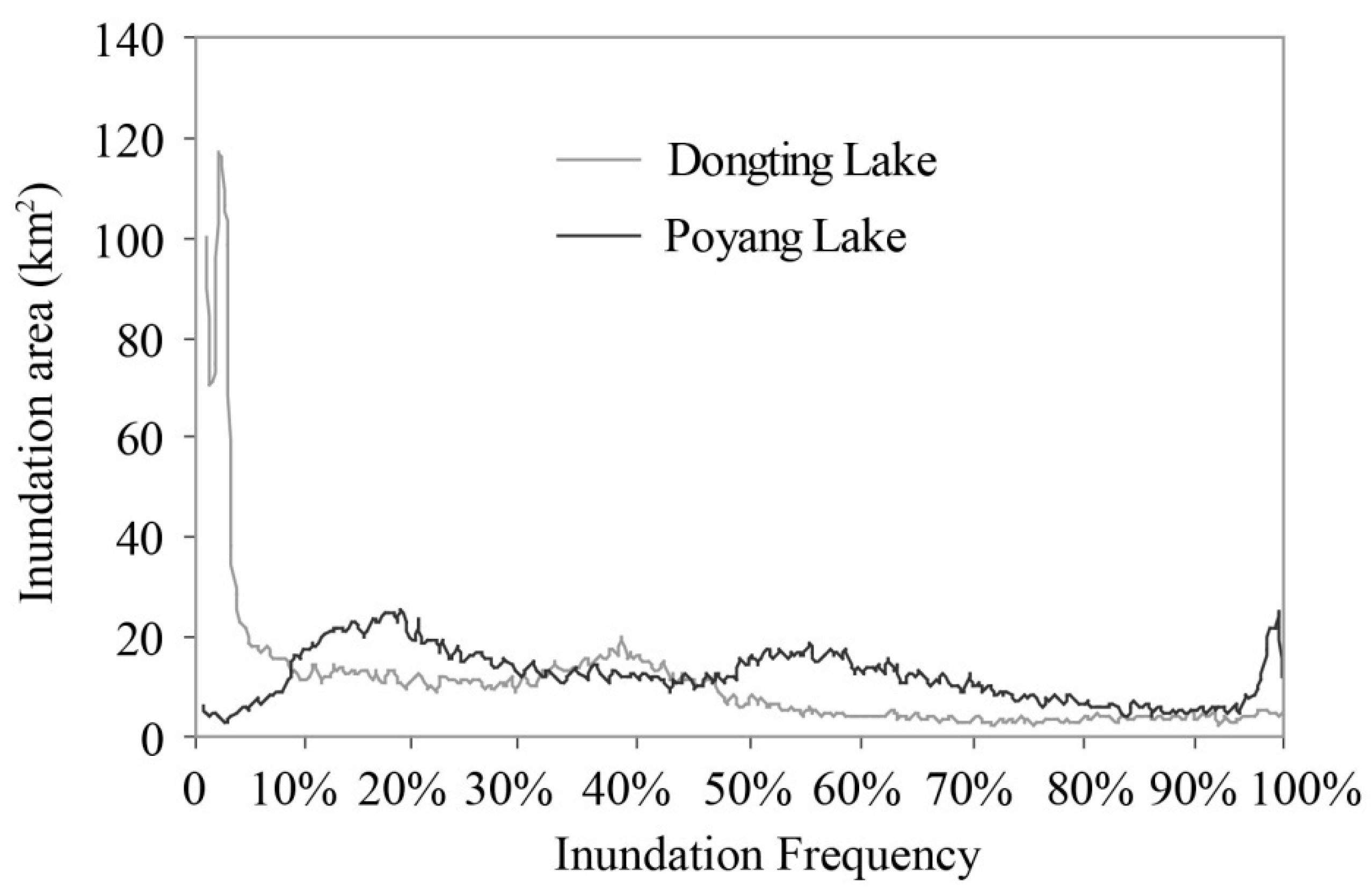
4.2. Spatial Dynamics of the Lake Inundation Extents
5. Discussion
6. Conclusions
Acknowledgments
Author Contributions
Conflicts of Interest
References
- Beeton, A.M. Large freshwater lakes: Present state, trends, and future. Environ. Conserv. 2002, 29, 21–38. [Google Scholar] [CrossRef]
- Williamson, C.E.; Saros, J.E.; Vincent, W.F.; Smol, J.P. Lakes and reservoirs as sentinels, integrators, and regulators of climate change. Limnol. Oceanogr. 2009, 54, 2273–2282. [Google Scholar] [CrossRef]
- Hampton, S.E.; Izmest’eva, L.R.; Moore, M.V.; Katz, S.L.; Dennis, B.; Silow, E.A. Sixty years of environmental change in the world’s largest freshwater lake e Lake Baikal, Siberia. Glob. Chang. Biol. 2008, 14, 1947–1958. [Google Scholar] [CrossRef]
- Lennox, B.; Spooner, I.; Jull, T.; Patterson, W. Post-glacial climate change and its effect on a shallow dimictic lake in Nova Scotia, Canada. J. Paleolimnol. 2010, 43, 15–27. [Google Scholar] [CrossRef]
- Gao, H.; Bohn, T.J.; Podest, E.; McDonald, K.C.; Lettenmaier, D.P. On the causes of the shrinking of Lake Chad. Environ. Res. Lett. 2011, 6, 034021. [Google Scholar] [CrossRef]
- Ariztegui, D.; Anselmetti, F.S.; Robbiani, J.M.; Bernasconi, S.M.; Brati, E.; Gilli, A.; Lehmann, M.F. Natural and human-induced environmental change in southern Albania for the last 300 years–Constraints from the Lake Butrint sedimentary record. Glob. Planet. Chang. 2010, 71, 183–192. [Google Scholar] [CrossRef]
- Du, Y.; Xue, H.P.; Wu, S.J.; Ling, F.; Xiao, F.; Wei, X.H. Lake area changes in the middle Yangtze region of China over the 20th century. J. Environ. Manag. 2011, 92, 1248–1255. [Google Scholar] [CrossRef] [PubMed]
- Junk, W.J. The central Amazon floodplain: Ecology of a pulsing system. In Ecological Studies; Springer: New York, NY, USA, 2013; pp. 3–5. [Google Scholar]
- Hamilton, S.K.; Suzanne, J.S.; John, M.M. Seasonal inundation patterns in two large savanna floodplains of South America: The Llanos de Moxos (Bolivvia) and the Llanos del Orinoco (Venezuela and Colombia). Hydrol. Process. 2004, 18, 2103–2116. [Google Scholar] [CrossRef]
- Decharme, B.; Douville, H.; Prigent, C.; Papa, F.; Aires, F. A new river flooding scheme for global climate applications: Off-line validation over South America. J. Geophys. Res. 2008, 113, D11110. [Google Scholar] [CrossRef]
- Wang, S.M.; Dou, H.H.; Chen, K.Z.; Wang, X.C.; Jiang, J.H. Chinese Lake Catalogue; Science Press: Beijing, China, 1998. [Google Scholar]
- Olson, D.M.; Dinerstein, E. The Global 200: Priority ecoregions for global conservation. Ann. Mo. Bot. Gard. 2002, 89, 199–224. [Google Scholar] [CrossRef]
- Lai, X.J.; Liang, Q.H.; Jiang, J.H.; Huang, Q. Impoundment effects of the Three-Gorges-Dam on flow regimes in two China’s largest freshwater lakes. Water Resour. Manag. 2014, 28, 5111–5124. [Google Scholar] [CrossRef]
- Huang, S.F.; Li, J.G.; Xu, M. Water surface variations monitoring and flood hazard analysis in Dongting Lake area using long-term Terra/MODIS data time series. Nat. Hazards 2012, 62, 93–100. [Google Scholar] [CrossRef]
- Feng, L.; Hu, C.M.; Chen, X.L.; Cai, X.B.; Tian, L.Q.; Gan, W.X. Assessment of inundation changes of Poyang Lake using MODIS observations between 2000 and 2010. Remote Sens. Environ. 2012, 121, 80–92. [Google Scholar] [CrossRef]
- Wang, J.D.; Sheng, Y.W.; Tong, T.S.D. Monitoring decal lake dynamics across the Yangtze Basin downstream of Three Gorges Dam. Remote Sens. Environ. 2014, 152, 251–269. [Google Scholar] [CrossRef]
- Liu, Y.B.; Wu, G.P.; Zhao, X.S. Recent declines in China’s largest freshwater lake: Trend or regime shift? Environ. Res. Lett. 2013, 8, 014010. [Google Scholar] [CrossRef]
- Feng, L.; Hu, C.M.; Cheng, X.L.; Zhao, X. Dramatic inundation changes of China’s two largest freshwater lakes linked to the Three Gorges Dam. Environ. Sci. Technol. 2013, 47, 9628–9634. [Google Scholar] [CrossRef] [PubMed]
- Zhao, X.; Stein, A.; Chen, X.L.; Feng, L. Modeling spatial-temporal change of Poyang Lake marshland based on an uncertainty theory-random sets. Proc. Environ. Sci. 2011, 3, 105–110. [Google Scholar] [CrossRef]
- Ding, X.W.; Li, X.F. Monitoring of the water-area variations of Lake Dongting in China with ENVISAT ASAR images. Int. J. Appl. Earth Obs. 2011, 13, 894–901. [Google Scholar] [CrossRef]
- Cui, L.J.; Gao, C.J.; Zhao, X.S.; Ma, Q.F.; Zhang, M.F.; Li, W.; Song, H.T. Dynamics of the lakes in the middle and lower reaches of the Yangtze River basin, China, since late nineteenth century. Environ. Monit. Asssess. 2013, 185, 4005–4018. [Google Scholar] [CrossRef] [PubMed]
- Deng, F.; Wang, X.L.; Cai, X.B.; Li, E.H.; Jiang, L.Z.; Li, H.; Yan, R.R. Analysis of the relationship between inundation frequency and wetland vegetation in Dongting Lake using remote sensing data. Ecohydrology 2014, 7, 717–726. [Google Scholar] [CrossRef]
- Wu, G.P.; Liu, Y.B. Capturing variations in inundation with satellite remote sensing in a morphologically complex, large lake. J. Hydrol. 2015, 523, 14–23. [Google Scholar] [CrossRef]
- Du, N.; Ottens, H.; Sliuzas, R. Spatial impact of urban expansion on surface water bodies—A case study of Wuhan, China. Landsc. Urban Plan. 2010, 94, 175–185. [Google Scholar] [CrossRef]
- Dewan, A.M.; Yamaguchi, Y. Effect of land cover changes on flooding: Example from Greater Dhaka of Bangladesh. Int. J. Geoinform. 2008, 4, 11–20. [Google Scholar]
- Shankman, D.; Liang, Q. Landscape changes and increasing flood frequency in China’s Poyang Lake region. Prof. Geogr. 2003, 55, 434–445. [Google Scholar] [CrossRef]
- Zhu, H.H.; Zhang, B. The Poyang Lake; Press of University of Science & Technology: Hefei, China, 1997. [Google Scholar]
- Hui, F.; Xu, B.; Huang, H.; Yu, Q.; Gong, P. Modelling spatial-temporal change of Poyang Lake using multitemporal Landsat imagery. Int. J. Remote Sens. 2008, 29, 5767–5784. [Google Scholar] [CrossRef]
- Dou, H.S.; Jiang, J.H. The Dongting Lake; Press of University of Science and Technology: Hefei, China, 2000. [Google Scholar]
- Yin, H.; Liu, G.; Pi, J. On the river-lake relationship of the middle Yangtze reaches. Geomorphology 2007, 85, 197–207. [Google Scholar] [CrossRef]
- McFeeters, S.K. The use of the normalized difference water index (NDWI) in the delineation of open water features. Int. J. Remote Sens. 1996, 17, 1425–1432. [Google Scholar] [CrossRef]
- Liu, Y.B.; Song, P.; Peng, J.; Ye, C. A physical explanation of the variation in threshold for delineating terrestrial water surface from multi-temporal images: Effects of radiometric correction. Int. J. Remote Sens. 2012, 33, 5862–5875. [Google Scholar] [CrossRef]
- Wu, G.P.; Liu, Y.B. Satellite-based detection of water surface variation in China’s largest freshwater lake in response to hydro-climatic drought. Int. J. Remote Sens. 2014, 35, 4511–4558. [Google Scholar] [CrossRef]
- Du, Y.; Cai, S.; Zhang, X. Interpretation of the environmental change of Dongting Lake, middle reach of Yangtze River, China, by 210 Pb measurement and satellite image analysis. Geomorphology 2001, 41, 171–181. [Google Scholar]
- Feng, L.; Hu, C.; Chen, X. MODIS observations of the bottom topography and its inter-annual variability of Poyang Lake. Remote Sens. Environ. 2011, 35, 2729–2741. [Google Scholar] [CrossRef]
- Yan, D.; Schneider, U.A.; Schmid, E. Interactions between land use change, regional development, and climate change in the Poyang Lake district from 1985 to 2035. Agric. Syst. 2013, 119, 10–21. [Google Scholar] [CrossRef]
- Zhao, J.K.; Li, J.F.; Dai, Z.J.; Yan, H. Analysis of water exchange between river and lakes in the middle and lower Yangtze River in low flow years. J. Nat. Resour. 2011, 26, 1613–1627. [Google Scholar]
- Dewan, A.M.; Islam, M.M.; Kumamoto, T.; Nishigaki, M. Evaluating flood hazard for land-use planning in Greater Dhaka of Bangladesh using remote sensing and GIS techniques. Water Resour. Manag. 2007, 21, 1601–1612. [Google Scholar] [CrossRef]
- Sparks, R.E. Need for ecosystem management of large rivers and floodplains. Bioscience 1995, 45, 168–182. [Google Scholar] [CrossRef]


© 2016 by the authors; licensee MDPI, Basel, Switzerland. This article is an open access article distributed under the terms and conditions of the Creative Commons Attribution (CC-BY) license (http://creativecommons.org/licenses/by/4.0/).
Share and Cite
Wu, G.; Liu, Y. Mapping Dynamics of Inundation Patterns of Two Largest River-Connected Lakes in China: A Comparative Study. Remote Sens. 2016, 8, 560. https://doi.org/10.3390/rs8070560
Wu G, Liu Y. Mapping Dynamics of Inundation Patterns of Two Largest River-Connected Lakes in China: A Comparative Study. Remote Sensing. 2016; 8(7):560. https://doi.org/10.3390/rs8070560
Chicago/Turabian StyleWu, Guiping, and Yuanbo Liu. 2016. "Mapping Dynamics of Inundation Patterns of Two Largest River-Connected Lakes in China: A Comparative Study" Remote Sensing 8, no. 7: 560. https://doi.org/10.3390/rs8070560
APA StyleWu, G., & Liu, Y. (2016). Mapping Dynamics of Inundation Patterns of Two Largest River-Connected Lakes in China: A Comparative Study. Remote Sensing, 8(7), 560. https://doi.org/10.3390/rs8070560


