
Improved Geoarchaeological Mapping with Electromagnetic Induction Instruments from Dedicated Processing and Inversion

 ,
,
Abstract
:
1. Introduction
- The EM fields from an EMI instrument are diffusive and will average over a certain volume depending on the instrument design. Hence, a given data point never reflects a certain place in space. The deeper the target depth, the larger the averaging volume.
- Calculating the full forward response is computationally efficient, making CPU time negligible.
- Dedicated tools for continuous datasets, such as Aarhus Workbench [34], are ready off-the-shelf.
- The full solution provides a more robust interpretation of the archaeological and geological features than derived via approximations or raw data analysis.
2. Materials and Methods
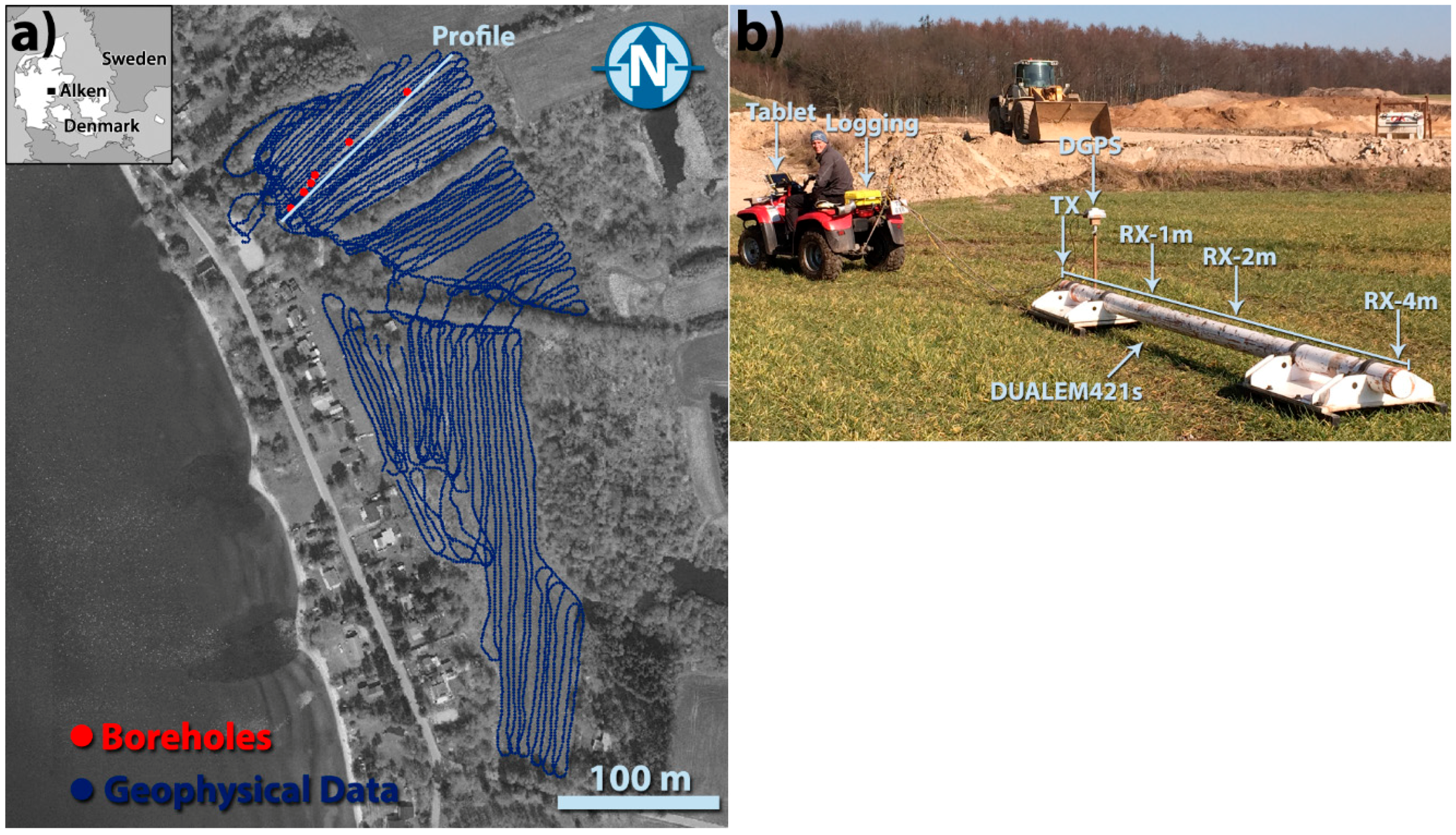
2.1. Study Site
2.2. Instrumental Setup and Field Work
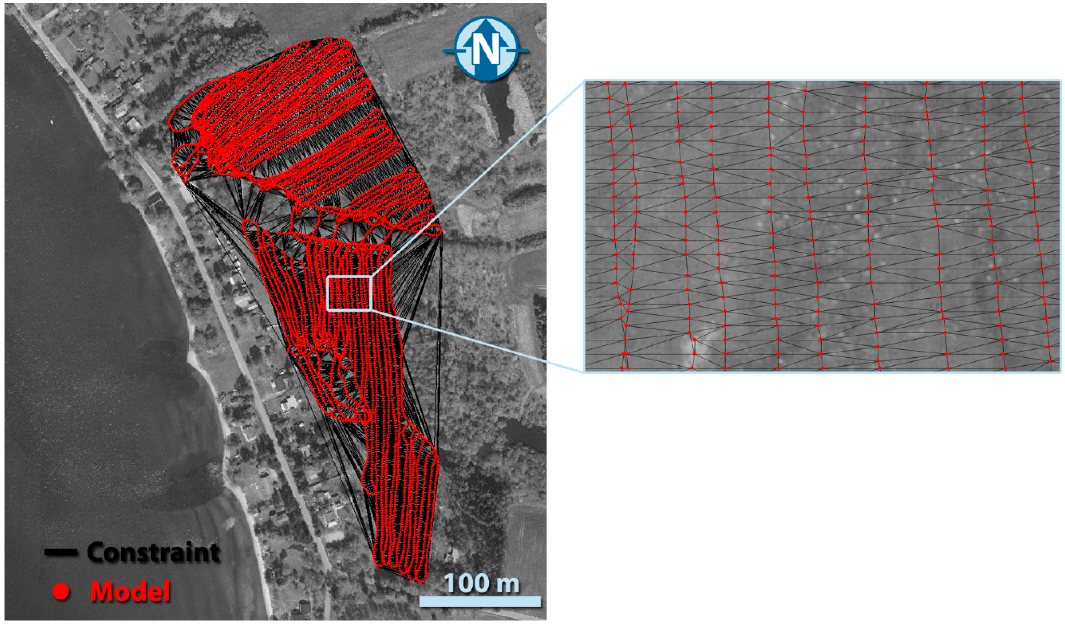
2.3. Data Processing and Modelling
- Negative data are removed.
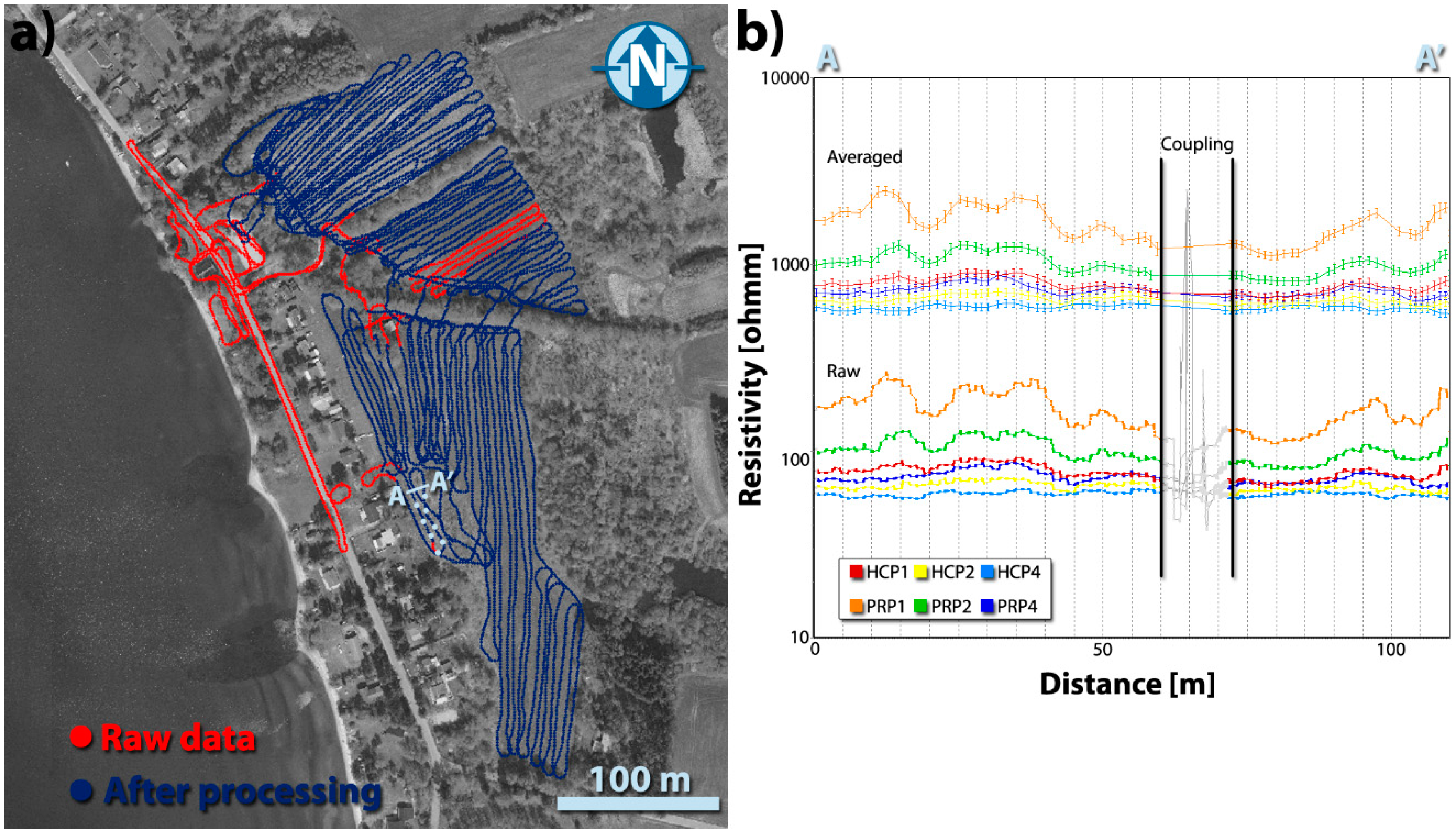
- Manual inspection of the raw data series with the primary target to identify couplings to human-made structures as buried cables, pipelines, metal fences, etc. Coupling effects are often easily identified by inspecting the GIS map with wire-installations shown together with the raw data. Figure 2a shows the full dataset with red dots whereas the superimposed blue dots show the resulting dataset after manual removal of couplings and noisy data. Figure 2b shows an example of a coupling in the dataset, which arises from a powered pump station. The effect of the manual processing for the entire survey is shown in the results section.
- The data are then averaged to improve the S/N-ratio. This is done by a running mean with a specified filter length, followed by a polynomial fit. The running mean filter length is typically in the order of 2–10 m, depending on the signal to noise ratio and the geological variability at hand. As the filter is a function of distance and not time, the number of measurements included in the filter will vary with the acquisition speed. In this process, great care is needed to make sure that geological structures are not smeared out by the averaging. Figure 2b shows a stretch of survey line with raw data as well as averaged data. Here, the averaging filter was set at 5 m.
- The averaged data are assigned noise according to (1) the absolute signal level with respect to absolute noise thresholds for the individual channels, and (2) the variance of the data entering the median filter. Here, the absolute noise level was set uniformly on all six channels to 0.6 mS/m based on on-site repetitive measurements. A sound estimate of noise-levels on the data are crucial for making a meaningful inversion later.
- Soundings for inversion are taken out at user-specified intervals, typically every 1–5 m. The trade-off is between computation speed and redundant information. There is no risk in choosing too low a sounding distance, but the soundings will then contain a lot of redundant information and the computation time for the subsequent inversion will go up. Here, a sounding distance of 1 m was chosen as some of the paleo-structures were thought to be quite small. The total number of raw measurements were 90,949. After processing and with one sounding every 1 m the total number of datasets (each with six data points) ready for inversion ends at 13,043.
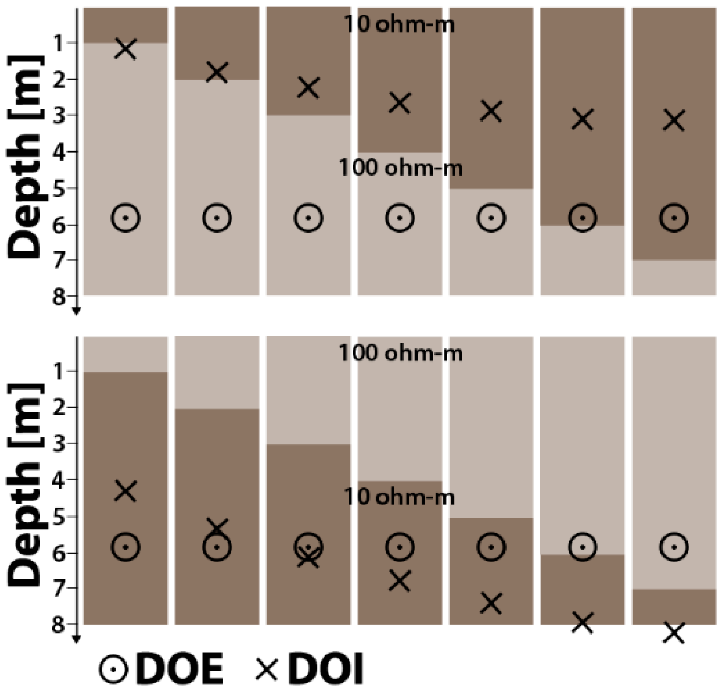
2.4. Comparing Approximate Modelling and Full Non-Linear Solution
3. Results and Discussion
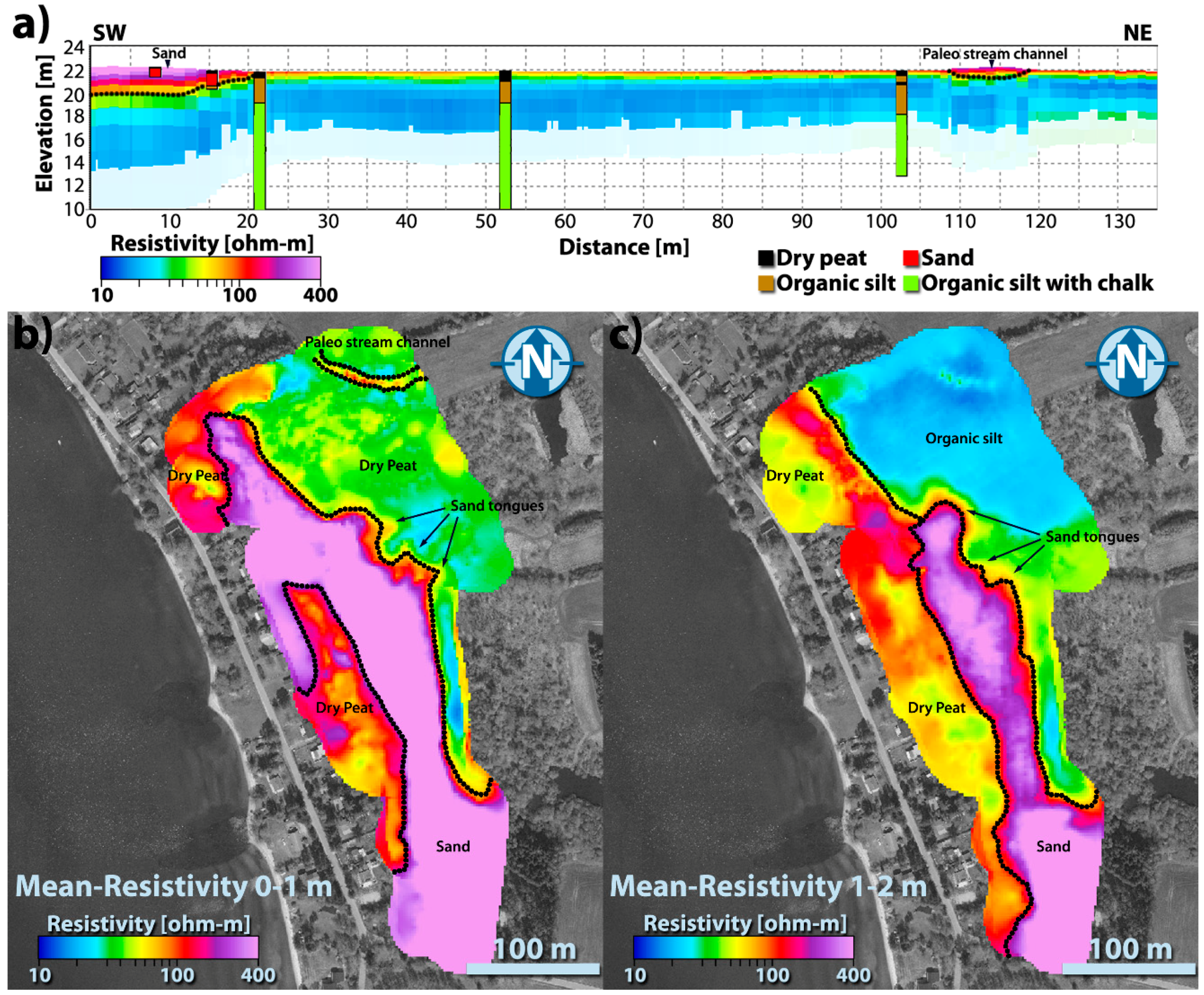
3.1. Geophysical Results and Borehole Comparison
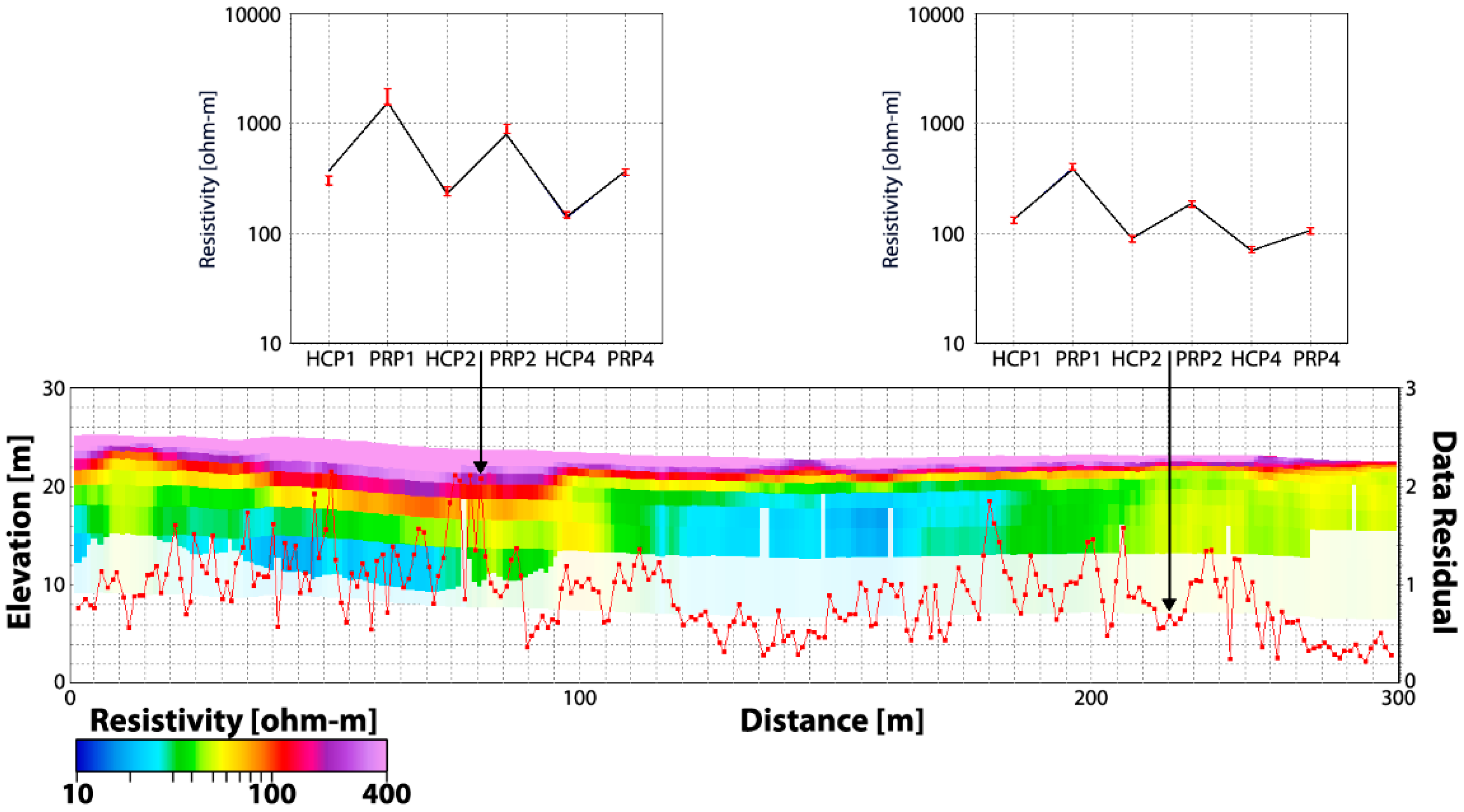
3.2. Comparing Data Values with Full Solution on the Field Case
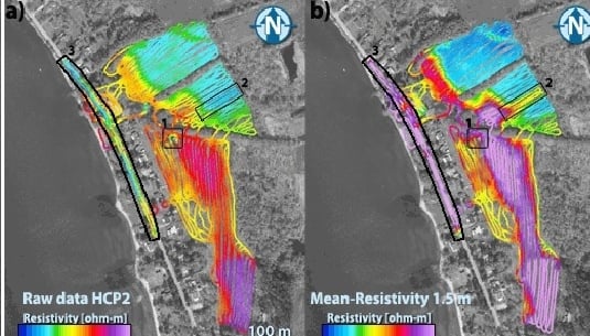
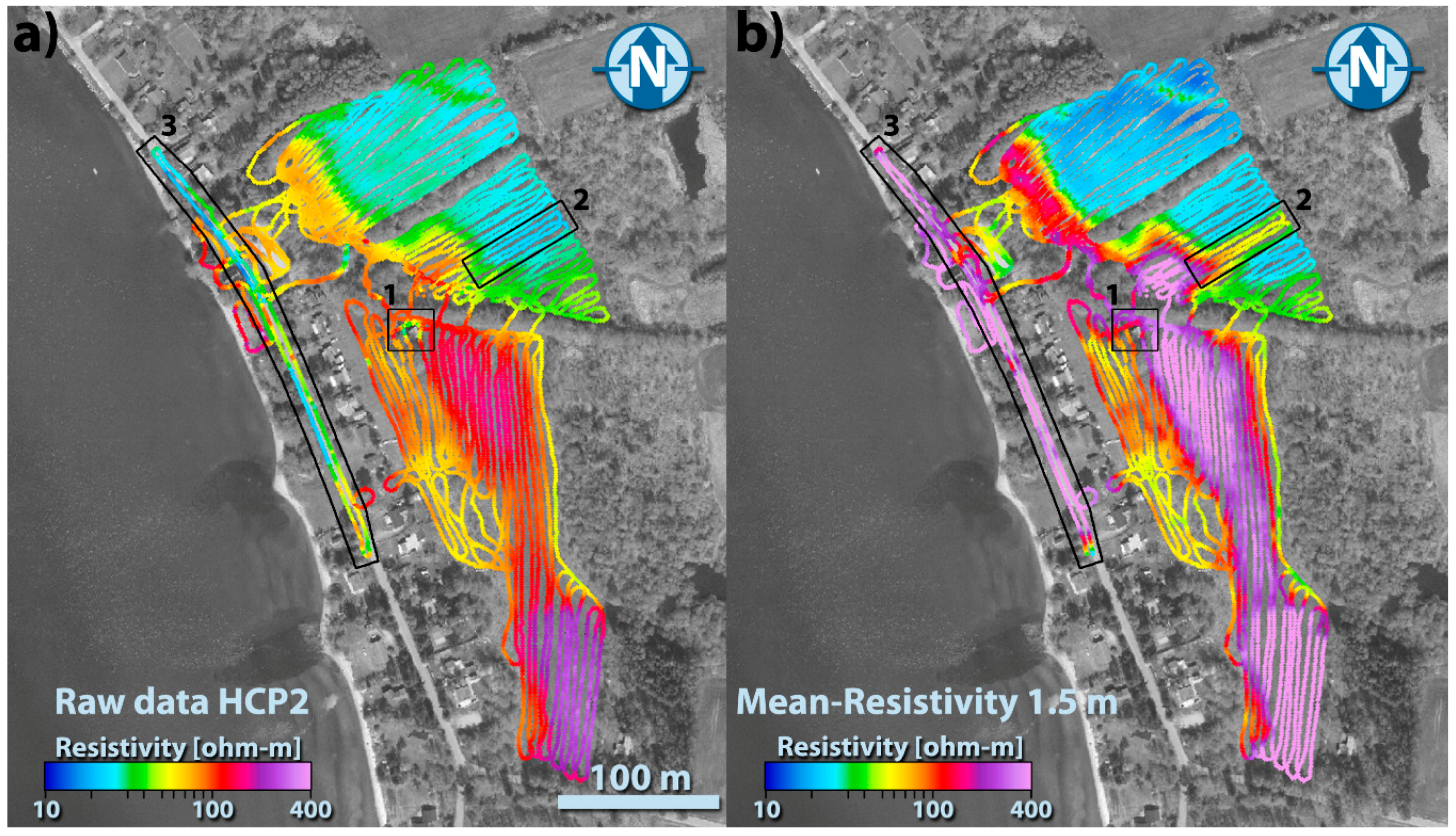
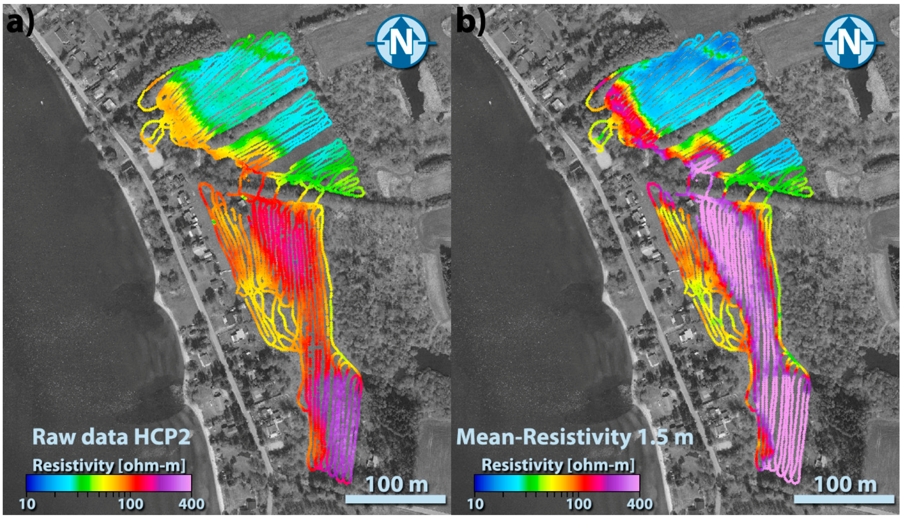
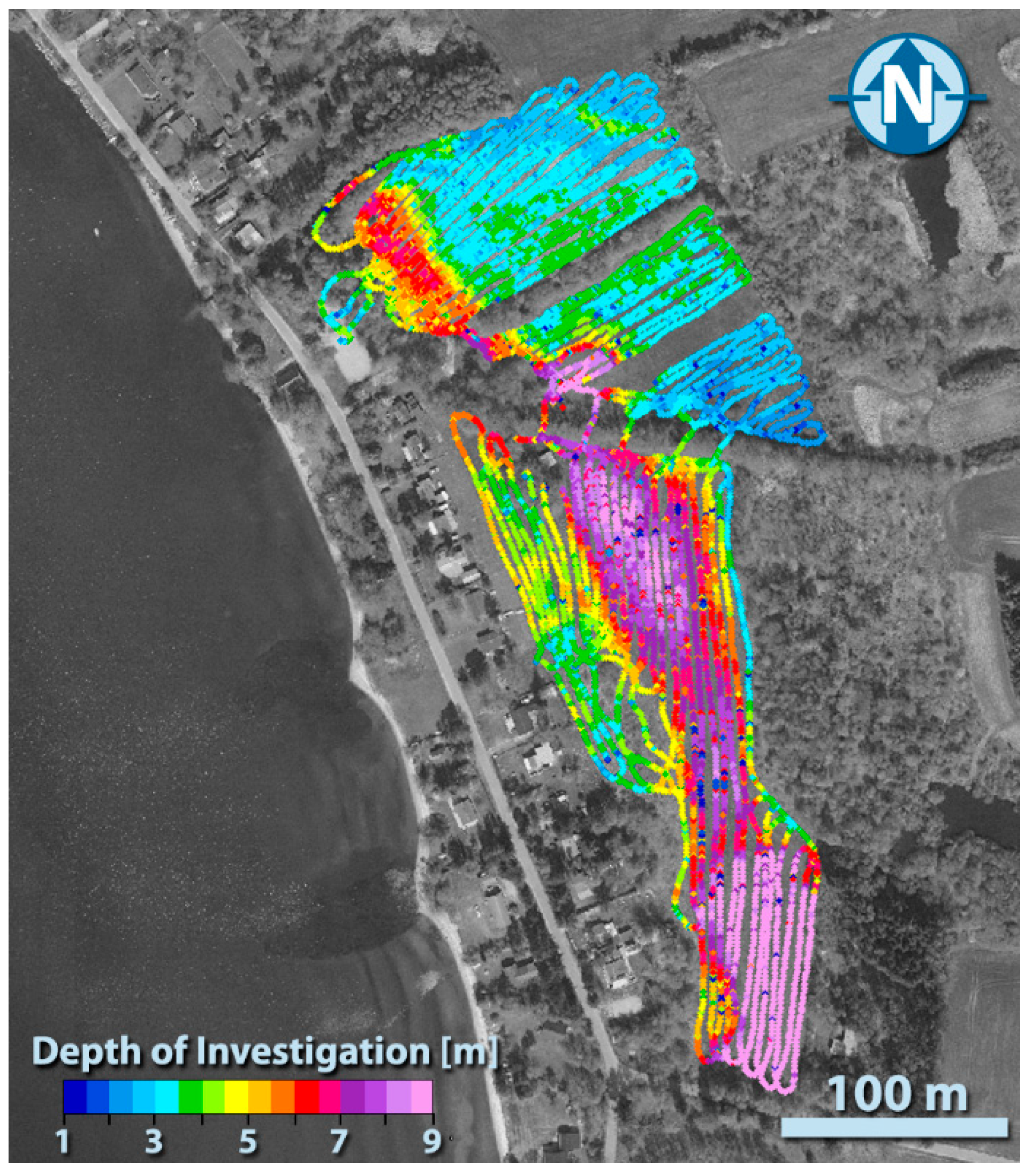
3.3. Evaluating the Benefit of Processing the Data before Inversion
4. Conclusions
Acknowledgments
Author Contributions
Conflicts of Interest
References
- Gaffney, C. Detecting trends in the prediction of the buried past: A review of geophysical techniques in archaeology. Archaeometry 2008, 50, 313–336. [Google Scholar] [CrossRef]
- Saey, T.; Van Meirvenne, M.; De Smedt, P.; Stichelbaut, B.; Delefortrie, S.; Baldwin, E.; Gaffney, V. Combining EMI and GPR for non-invasive soil sensing at the Stonehenge World Heritage Site: The reconstruction of a WW1 practice trench. Eur. J. Soil Sci. 2015, 66, 166–178. [Google Scholar] [CrossRef]
- Linford, N.; Linford, P.; Martin, L.; Payne, A. Recent results from the English Heritage caesium magnetometer system in comparison with recent fluxgate gradiometers. Archaeol. Prospect. 2007, 14, 151–166. [Google Scholar] [CrossRef]
- Bonsall, J.; Fry, R.; Gaffney, C.; Armit, I.; Beck, A.; Gaffney, V. Assessment of the CMD mini-explorer, a new low-frequency multi-coil electromagnetic device, for archaeological investigations. Archaeol. Prospect. 2013, 20, 219–231. [Google Scholar] [CrossRef]
- Bates, M.R.; Bates, C.R.; Whittaker, J.E. Mixed method approaches to the investigation and mapping of buried Quaternary deposits: Examples from southern England. Archaeol. Prospect. 2007, 14, 104–129. [Google Scholar] [CrossRef]
- De Smedt, P.; Saey, T.; Lehouck, A.; Stichelbaut, B.; Meerschman, E.; Islam, M.M.; De Vijver, E.V.; Van Meirvenne, M. Exploring the potential of multi-receiver EMI survey for geoarchaeological prospection: A 90ha dataset. Geoderma 2013, 199, 30–36. [Google Scholar] [CrossRef]
- De Smedt, P.; Van Meirvenne, M.; Saey, T.; Baldwin, E.; Gaffney, C.; Gaffney, V. Unveiling the prehistoric landscape at Stonehenge through multi-receiver EMI. J. Archaeol. Sci. 2014, 50, 16–23. [Google Scholar] [CrossRef]
- Jiang, P.P.; He, Z.Q.; Kitchen, N.R.; Sudduth, K.A. Bayesian analysis of within-field variability of corn yield using a spatial hierarchical model. Precis. Agric. 2009, 10, 111–127. [Google Scholar] [CrossRef]
- Lopez-Lozano, R.; Casterad, M.A.; Herrero, J. Site-specific management units in a commercial maize plot delineated using very high resolution remote sensing and soil properties mapping. Comput. Electron. Agric. 2010, 73, 219–229. [Google Scholar] [CrossRef]
- Eigenberg, R.A.; Woodbury, B.L.; Nienaber, J.A.; Spiehs, M.J.; Parker, D.B.; Varel, V.H. Soil conductivity and multiple linear regression for precision monitoring of beef feedlot manure and runoff. J. Environ. Eng. Geophys. 2010, 15, 175–184. [Google Scholar] [CrossRef]
- Serrano, J.M.; Shahidian, S.; da Silva, J.R.M. Apparent electrical conductivity in dry versus wet soil conditions in a shallow soil. Precis. Agric. 2013, 14, 99–114. [Google Scholar] [CrossRef]
- Everett, M.E. Theoretical developments in electromagnetic induction geophysics with selected applications in the near surface. Surv. Geophys. 2012, 33, 29–63. [Google Scholar] [CrossRef]
- Doolittle, J.A.; Brevik, E.C. The use of electromagnetic induction techniques in soils studies. Geoderma 2014, 223, 33–45. [Google Scholar] [CrossRef]
- Calamita, G.; Perrone, A.; Brocca, L.; Onorati, B.; Manfreda, S. Field test of a multi-frequency electromagnetic induction sensor for soil moisture monitoring in southern Italy test sites. J Hydrol. 2015, 529, 316–329. [Google Scholar] [CrossRef]
- McNeill, J.D. Why Doesn’t Geonics Limited Build a Multi-Frequency EM31 or EM38? Technical note TN-30; Geonics Limited: Mississauaga, ON, Canada, 1996. [Google Scholar]
- McNeill, J. Electromagnetic Terrain Conductivity Measurement at Low Induction Numbers; Technical Report TN-6; Geonics Limited: Mississauga, ON, Canada, 1980. [Google Scholar]
- Callegary, J.B.; Ferre, T.P.A.; Groom, R.W. Vertical spatial sensitivity and exploration depth of low-induction-number electromagnetic-induction instruments. Vadose Zone J. 2007, 6, 158–167. [Google Scholar] [CrossRef]
- Callegary, J.B.; Ferré, T.P.A.; Groom, R.W. Three-dimensional sensitivity distribution and sample volume of low-induction-number electromagnetic-induction instruments. Soil Sci. Soc. Am. J. 2012, 76, 85–91. [Google Scholar] [CrossRef]
- Wait, J.R. A note on the electromagnetic response of a stratified earth. Geophysics 1962, 27, 382–385. [Google Scholar] [CrossRef]
- Santos, F.A.M. 1-D laterally constrained inversion of EM34 profiling data. J. Appl. Geophys. 2004, 56, 123–134. [Google Scholar] [CrossRef]
- De Smedt, P.; Van Meirvenne, M.; Herremans, D.; De Reu, J.; Saey, T.; Meerschman, E.; Crombé, P.; De Clercq, W. The 3-D reconstruction of medieval wetland reclamation through electromagnetic induction survey. Sci. Rep. 2013, 3. [Google Scholar] [CrossRef] [PubMed]
- Saey, T.; De Smedt, P.; Meerschman, E.; Islam, M.M.; Meeuws, F.; Van De Vijver, E.; Lehouck, A.; Van Meirvenne, M. Electrical conductivity depth modelling with a multireceiver EMI sensor for prospecting archaeological features. Archaeol. Prospect. 2012, 19, 21–30. [Google Scholar] [CrossRef]
- Zare, E.; Huang, J.; Santos, F.A.M.; Triantafilis, J. Mapping salinity in three dimensions using a DualEM-421 and electromagnetic inversion software. Soil Sci. Soc. Am. J. 2015, 79, 1729–1740. [Google Scholar] [CrossRef]
- Mester, A.; Van Der Kruk, J.; Zimmermann, E.; Vereecken, H. Quantitative two-layer conductivity inversion of multi-configuration electromagnetic induction measurements. Vadose Zone J. 2011, 10, 1319–1330. [Google Scholar] [CrossRef]
- Dafflon, B.; Hubbard, S.S.; Ulrich, C.; Peterson, J.E. Electrical conductivity imaging of active layer and permafrost in an Arctic ecosystem, through advanced inversion of electromagnetic induction data. Vadose Zone J. 2013, 12. [Google Scholar] [CrossRef]
- Jadoon, K.Z.; Moghadas, D.; Jadoon, A.; Missimer, T.M.; Al-Mashharawi, S.K.; McCabe, M.F. Estimation of soil salinity in a drip irrigation system by using joint inversion of multicoil electromagnetic induction measurements. Water Resour. Res. 2015, 51, 3490–3504. [Google Scholar] [CrossRef]
- Lee, B.D.; Jenkinson, B.J.; Doolittle, J.A.; Taylor, R.S.; Tuttle, J.W. Electrical conductivity of a failed septic system soil absorption field. Vadose Zone J. 2006, 5, 757–763. [Google Scholar] [CrossRef]
- Saey, T.; De Smedt, P.; De Clercq, W.; Meerschman, E.; Monirul Islam, M.; Van Meirvenne, M. Identifying soil patterns at different spatial scales with a multi-receiver emi sensor. Soil Sci. Soc. Am. J. 2013, 77, 382–390. [Google Scholar] [CrossRef]
- Benech, C.; Dabas, M.; Simon, F.-X.; Tabbagh, A.; Thiesson, J. Interpretation of shallow electromagnetic instruments resistivity and magnetic susceptibility measurements using rapid 1D/3D inversion. Geophysics 2016, 81, E103–E112. [Google Scholar] [CrossRef]
- Dabas, M.; Anest, A.; Thiesson, J.; Tabbagh, A. Slingram EMI devices for characterizing resistive features using apparent conductivity measurements: Check of the DualEM-421S instrument and field tests. Archaeol. Prospect. 2016, 23, 165–180. [Google Scholar] [CrossRef]
- Triantafilis, J.; Wong, V.; Santos, F.A.M.; Page, D.; Wege, R. Modeling the electrical conductivity of hydrogeological strata using joint-inversion of loop-loop electromagnetic data. Geophysics 2012, 77, WB99–WB107. [Google Scholar] [CrossRef]
- Siemon, B.; Christiansen, A.V.; Auken, E. A review of helicopter-borne electromagnetic methods for groundwater exploration. Near Surf. Geophys. 2009, 7, 629–646. [Google Scholar] [CrossRef]
- Sengpiel, K.P.; Siemon, B. Advanced inversion methods for airborne electromagnetic exploration. Geophysics 2000, 65, 1983–1992. [Google Scholar] [CrossRef]
- Auken, E.; Viezzoli, A.; Christiansen, A.V. A single software for processing, inversion, and presentation of AEM data of different systems: The Aarhus Workbench. In Proceedings of the International Geophysical Conference and Exhibition, Adelaide, SA, Australia, 22–25 February 2009; pp. 1–5.
- Auken, E.; Christiansen, A.V.; Westergaard, J.A.; Kirkegaard, C.; Foged, N.; Viezzoli, A. An integrated processing scheme for high-resolution airborne electromagnetic surveys, the SkyTEM system. Explor. Geophys. 2009, 40, 184–192. [Google Scholar] [CrossRef]
- Pedersen, J.B.; Auken, E.; Vest, C.A.; Kristiansen, S.M. Mapping soil heterogeneity using spatially constrained inversion of electromagnetic induction data. In Proceedings of the First Conference on Proximal Sensing Supporting Precision Agriculture, Turin, Italy, 6 September 2015.
- Søe, N.E.; Odgaard, B.; Hertz, E.; Holst, M.K.; Kristiansen, S.M. Geological setting of a sacred landscape: Iron age post battle depositions at Alken Enge, Denmark. Geoarchaeology 2016. submitted. [Google Scholar]
- Lavoué, F.; Van Der Kruk, J.; Rings, J.; André, F.; Moghadas, D.; Huisman, J.A.; Lambot, S.; Weihermüller, L.; Vanderborght, J.; Vereecken, H. Electromagnetic induction calibration using apparent electrical conductivity modelling based on electrical resistivity tomography. Near Surf. Geophys. 2010, 8, 553–561. [Google Scholar] [CrossRef]
- Auken, E.; Christiansen, A.V.; Fiandaca, G.; Schamper, C.; Behroozmand, A.A.; Binley, A.; Nielsen, E.; Effersø, F.; Christensen, N.B.; Sørensen, K.I.; et al. An overview of a highly versatile forward and stable inverse algorithm for airborne, ground-based and borehole electromagnetic and electric data. Explor. Geophys. 2015, 46, 223–235. [Google Scholar] [CrossRef]
- Podgorski, J.E.; Green, A.G.; Kalscheuer, T.; Kinzelbach, W.; Horstmeyer, H.; Maurer, H.; Rabenstein, L.; Doetsch, J.; Auken, E.; Ngwisanyi, T.; et al. Integrated interpretation of helicopter and ground-based geophysical data recorded within the Okavango Delta, Botswana. J. Appl. Geophys. 2015, 114, 52–67. [Google Scholar] [CrossRef]
- Mikucki, J.A.; Auken, E.; Tulaczyk, S.; Virginia, R.A.; Schamper, C.; Sorensen, K.I.; Doran, P.T.; Dugan, H.; Foley, N. Deep groundwater and potential subsurface habitats beneath an Antarctic dry valley. Nat. Commun. 2015, 6. [Google Scholar] [CrossRef] [PubMed]
- Auken, E.; Violette, S.; d’Ozouville, N.; Deffontaines, B.; Sørensen, K.I.; Viezzoli, A.; de Marsily, G. An integrated study of the hydrogeology of volcanic islands using helicopter borne transient electromagnetic: Application in the Galápagos Archipelago. Comptes Rendus Geosci. 2009, 341, 899–907. [Google Scholar] [CrossRef]
- Viezzoli, A.; Christiansen, A.V.; Auken, E.; Sørensen, K.I. Quasi-3d modeling of airborne tem data by spatially constrained inversion. Geophysics 2008, 73, F105–F113. [Google Scholar] [CrossRef]
- Christiansen, A.V.; Auken, E. A global measure for depth of investigation. Geophysics 2012, 77, WB171–WB177. [Google Scholar] [CrossRef]
- Taylor, R. Apparent Conductivity as an Indicator of Thickness. Available online: http://www.dualem.com/acit.htm (accessed on 5 September 2016).
- Søe, N.E.; Odgaard, B.; Nielsen, A.B.; Olsen, J.; Kristiansen, S.M. The making of a sacred landscape: Late Holocene palaeoecology of Ilsø and the Illerup/Alken Enge valley, Denmark. Veg. Hist. Archaeobothany 2016. submitted. [Google Scholar]
- Tjelldén, A.K.E.; Matthiesen, H.; Petersen, L.M.M.; Søe, N.E.; Kristiansen, S.M. In-situ preservation solutions for deposited Iron age human bones in Alken Enge, Denmark. Conserv. Manag. Archaeol. Sites 2016, 18, 126–138. [Google Scholar] [CrossRef]


| Thickness, Upper Layer | 1 m | 2 m | 3 m | 4 m | 5 m | 6 m | 7 m |
|---|---|---|---|---|---|---|---|
| 10/100 ohm-m Model | |||||||
| DOI, full, all (m) | 1.2 | 1.8 | 2.3 | 2.7 | 2.9 | 3.1 | 3.2 |
| DOE, 4 m HCP (m) | 5.8 | 5.8 | 5.8 | 5.8 | 5.8 | 5.8 | 5.8 |
| Abs error (m) | 4.6 | 4.0 | 3.5 | 3.1 | 2.9 | 2.7 | 2.6 |
| (4 m HCP, LIN) (ohm-m) | 44.7 | 25.6 | 19.3 | 16.4 | 14.9 | 13.9 | 13.3 |
| (4 m HCP, true) (ohm-m) | 47.2 | 26.7 | 20.1 | 17.2 | 15.7 | 14.8 | 14.3 |
| 100/10 ohm-m Model | |||||||
| DOI, full, all (m) | 4.3 | 5.3 | 6.1 | 6.8 | 7.4 | 7.9 | 8.3 |
| DOE, 4 m HCP (m) | 5.8 | 5.8 | 5.8 | 5.8 | 5.8 | 5.8 | 5.8 |
| Abs error (m) | 1.5 | 0.5 | −0.3 | −1.0 | −1.6 | −2.1 | −2.5 |
| (4 m HCP, LIN) (ohm-m) | 11.4 | 14.1 | 17.2 | 20.3 | 23.4 | 26.3 | 29.0 |
| (4 m HCP, true) (ohm-m) | 15.6 | 20.4 | 26.6 | 33.5 | 40.8 | 48.0 | 55.1 |
© 2016 by the authors; licensee MDPI, Basel, Switzerland. This article is an open access article distributed under the terms and conditions of the Creative Commons Attribution (CC-BY) license (http://creativecommons.org/licenses/by/4.0/).
Share and Cite
Christiansen, A.V.; Pedersen, J.B.; Auken, E.; Søe, N.E.; Holst, M.K.; Kristiansen, S.M. Improved Geoarchaeological Mapping with Electromagnetic Induction Instruments from Dedicated Processing and Inversion. Remote Sens. 2016, 8, 1022. https://doi.org/10.3390/rs8121022
Christiansen AV, Pedersen JB, Auken E, Søe NE, Holst MK, Kristiansen SM. Improved Geoarchaeological Mapping with Electromagnetic Induction Instruments from Dedicated Processing and Inversion. Remote Sensing. 2016; 8(12):1022. https://doi.org/10.3390/rs8121022
Chicago/Turabian StyleChristiansen, Anders Vest, Jesper Bjergsted Pedersen, Esben Auken, Niels Emil Søe, Mads Kähler Holst, and Søren Munch Kristiansen. 2016. "Improved Geoarchaeological Mapping with Electromagnetic Induction Instruments from Dedicated Processing and Inversion" Remote Sensing 8, no. 12: 1022. https://doi.org/10.3390/rs8121022
APA StyleChristiansen, A. V., Pedersen, J. B., Auken, E., Søe, N. E., Holst, M. K., & Kristiansen, S. M. (2016). Improved Geoarchaeological Mapping with Electromagnetic Induction Instruments from Dedicated Processing and Inversion. Remote Sensing, 8(12), 1022. https://doi.org/10.3390/rs8121022