
Mapping Indigenous Settlement Topography in the Caribbean Using Drones


Abstract
:
1. Background and Rationale
2. Objectives
3. Methods
4. Discussion
5. Conclusions
Acknowledgments
Author Contributions
Conflicts of Interest
References
- Las Casas, B. Historia de Las Indias TII; Imprenta de Miguel Ginesta: Madrid, Spain, 1875. [Google Scholar]
- Colón, F. Vida del Almirante; Fondo de Cultura Económica: Ciudad de México, Mexico, 1947. [Google Scholar]
- Samson, A.V.M. Renewing the House. Trajectories of Social Life in the Yucayeque (Community) of El Cabo, Higuey, Dominican Republic, AD 800 to 1504; Sidestone Press: Leiden, The Netherlands, 2010. [Google Scholar]
- Hofman, C.L.; Hoogland, M.L. Investigaciones arqueológicas en los sitios El Flaco (Loma de Guayacanes) y La Luperona (Unijica). Informe pre-liminar. Bol. Mus. Hombre Dominic. 2015, 46, 61–74. [Google Scholar]
- Boyrie Moya, E. Cinco años de Arqueología Dominicana. In Anales de la Universidad de Santo Domingo; Universidad de Santo Domingo: Santo Domingo, Dominican Republic, 1960; pp. 33–86. [Google Scholar]
- Veloz Maggiolo, M.; Ortega, E. Nuevos hallazgos arqueológicos en la costa norte de Santo Domingo. Bol. Mus. Hombre Dominic. 1980, 13, 11–48. [Google Scholar]
- Veloz Maggiolo, M.; Ortega, E.; Caba, Á. Los Modos de Vida Meillacoides y sus Posibles Orígenes; Editora Taller: Santo Domingo, Dominican Republic, 1981. [Google Scholar]
- Ortega, E.; Denis, P.; Olsen Bogaert, H. Nuevos yacimientos arqueológicos en Arroyo Caña. Bol. Mus. Hombre Dominic. 1990, 23, 29–40. [Google Scholar]
- Moore, C.; Tremmel, N. Clark Moore’s Archaeological Map of Haiti. Available online: http://www.nilstremmel.com/haiti/images/Clark_Moore_Haiti_sites.kmz (accessed on 20 September 2015).
- Ulloa Hung, J. Arqueología. en la Línea Noroeste de La Española Paisajes, Cerámicas e Interacciones; Instituto Tecnológico de Santo Domingo: Santo Domingo, Dominican Republic, 2014. [Google Scholar]
- Ulloa Hung, J. Informe de los Trabajos de Campo Realizados en Junio-Julio 2014; Proyecto NEXUS 1492; Inédito, Museo del Hombre Dominicano: Santo Domingo, Dominican Republic, 2014. [Google Scholar]
- Ulloa Hung, J.; de Ruiter, S. Arqueología en la línea noroeste de la República Dominicana. Un esbozo del paisaje arqueológico y las interacciones. Caribe Arqueol. 2011, 12, 60–75. [Google Scholar]
- Deagan, K. Initial Encounters: Arawak Responses to European Contact at En Bas Saline Site, Haiti. In Proceedings of the First San Salvador Conference Columbus and His World, North Cansas City, MO, USA, 30 October–3 November 1987; pp. 341–359.
- Deagan, K.; Cruxent, J.M. From contact to criollos: The archaeology of Spanish Colonization in Hispaniola. Proc. Br. Acad. 1993, 81, 67–104. [Google Scholar]
- Ulloa Hung, J.; Herrera Malatesta, E. Investigaciones Arqueológicas en el Norte de La Española, Entre Viejos Esquemas y Nuevos Datos; Boletín del Museo del Hombre Dominicano: Santo Domingo, Dominican Republic, 2015. [Google Scholar]
- Herrera Malatesta, E. La Construcción del Territorio en el Nuevo Mundo: Cartografía colonial y asentamientos indígenas en el norte de la Republica Dominicana. Chungara, Revista de Antropologia Chilena 2016. submitted. [Google Scholar]
- Ortega, E.; Veloz Maggiolo, M. Excavación Arqueológica en el vasto residuario indígena de Hatillo Palma. Rev. Dominic. Arqueol. Antropol. 1972, 2, 5–27. [Google Scholar]
- Luna Calderón, F. El cementerio de La Unión. Provincia Puerto Plata. Bol. Mus. Hombre Dominic. 1973, 2, 130–146. [Google Scholar]
- Peña Sosa, S. Aspectos Arqueológicos de Río San Juan. Bol. Mus. Hombre Dominic. 1978, 11, 131–140. [Google Scholar]
- Marichal, P. Poblamientos aborígenes de la zona del Montecristi Histórico. Bol. Mus. Hombre Dominic. 1994, 26, 15–32. [Google Scholar]
- Keegan, W.F. Archaeological Investigations on Ile A Rat, Haití. In Association Internationale d’Archéologie de la Caraïbe Région Guadeloupe, Proceedings of the 18th International Congress for Caribbean Archaeology, Grenada, West Indies, 11–17 July 1999; pp. 233–239.
- Olsen Bogaert, H.; Pagán Perdomo, D.; Munera, L.C. Estudio de Impacto Ambiental Selección de Rutas y Topografía de líneas de Transmisión y subestaciones Aspectos Arqueológicos; Archived manuscript; Museo del Hombre Dominicano: Santo Domingo, Dominican Republic, 2000. [Google Scholar]
- De Grossi, J.; Tavarez, C.; Coppa, A. Reporte preliminar de los restos arqueozoológicos de Loma Perenal (Puerto Plata, República Dominicana, XII-XIII siglo AD). Bol. Mus. Hombre Dominic. 2008, 42, 317–323. [Google Scholar]
- Koski-Karell, D. Prehistoric Northem Haïti Settlement in Diacronic Ecological Context. Ph.D. Thesis, Catholic University of America, Washington, DC, USA, 2002. [Google Scholar]
- Sonnemann, T.; Herrera Malatesta, E.; Hofman, C.L. Applying UAS Photogrammetry to Analyze Spatial Patterns of Indigenous Settlement Sites in the Caribbean. In The Age of Sensing; Forte, M., Campana, S., Eds.; Springer Books: New York, NY, USA, 2016; in press. [Google Scholar]
- Veloz Maggiolo, M.; Vargas Arenas, I.; Sanoja, M.; Luna Calderón, F. Arqueología de Yuma; Editora Taller: Santo Domingo, Dominican Republic, 1976. [Google Scholar]
- Samson, A.V.M.; Hoogland, M.L.P. Residencia taina: Huellas de asentamiento en El Cabo. República Dominicana. Caribe Arqueol. 2007, 10, 93–102. [Google Scholar]
- Hofman, C.L.; Hoogland, M.L.P.; Samson, A.V.M.; Oliver, J.R. Investigaciones Arqueológicas En El Cabo, Oriente de La República Dominicana: Resultados Preliminares de Las Campañas 2005 y 2006. Bol. Mus. Hombre Dominic. 2008, 42, 307–316. [Google Scholar]
- López Belando, A. El Sitio Arqueológico Playa Grande Río San Juan, María Trinidad Sánchez Informe de las Excavaciones Arqueológicas Campaña 2011–2012; Museo del Hombre Dominicano: Santo Domingo, Dominican Republic, 2012. [Google Scholar]
- Deagan, K. Reconsidering Taino social dynamics after Spanish conquest: Gender and class in culture contact studies. Am. Antiq. 2004, 69, 597–626. [Google Scholar] [CrossRef]
- Veloz Maggiolo, M. La Isla de Santo Domingo Antes de Colón; Banco Central de la República Dominicana: Santo Domingo, Dominican Republic, 2003.
- De Ruiter, S. Mapping History. An Analysis of Site Locations in the North-Western Dominican Republic. Master’s Thesis, Leiden University, Leiden, The Netherlands, 2012. [Google Scholar]
- Welch, D. Geophysical Prospection at the Ceremonial Site of Tibes, 1998–2001. In Tibes, People, Power, and Ritual at the Center of the Cosmos; Curet, L.A., Stringer, L.M., Eds.; University Alabama Press: Tuscaloosa, AL, USA, 2010; pp. 60–79. [Google Scholar]
- Medica, D.; Mušič, B.; Samson, A. Recognition and interpretation of shallow microrelief features in limestone bedrock using the ground penetrating radar method, the case of El Cabo, Dominican Republic. Arheo 2010, 27, 15–43. (In Slovenian) [Google Scholar]
- Pincus, J.; Carr, R.; Whitman, D. Forthcoming. In Imaging Sub-Surface Features of the Miami Circle with GPR; University of Arizona’s Archaeological Sciences of the Americas Inaugural Symposium: Tucson, AZ, USA; Available online: http://www.mnemotrix.com/geo/mcircle/m_circ.doc (accessed on 2 May 2015).
- Opitz, R.; Ryzewski, K.; Cherry, J.; Moloney, B. Using Airborne LiDAR Survey to explore Historic-era archaeological landscapes of Montserrat in the Eastern Caribbean. J. Field Archaeol. 2015, 40, 523–541. [Google Scholar] [CrossRef]
- Aqdus, S.A.; Hanson, W.S.; Drummond, J. The potential of hyperspectral and multi-spectral imagery to enhance archaeological cropmark detection: A comparative study. J. Arch. Sci. 2012, 39, 1915–1924. [Google Scholar] [CrossRef]
- Tapete, D.; Cigna, F.; Masini, L.; Lasaponara, R. Prospection and monitoring of the archaeological heritage of Nasca, Peru with ENVISAT SAR. Archaeol. Prospect. 2013, 20, 133–147. [Google Scholar] [CrossRef]
- Sonnemann, T. Spatial configurations of water management at an early Angkorian capital—Combining GPR and TerraSAR-X data to complement an archaeol map. Arch. Prospect. 2015, 22, 105–115. [Google Scholar] [CrossRef]
- Nex, F.; Remondino, F. UAV: Platforms, regulations, data acquisition and processing. In 3D Re-Cording and Modelling in Archaeology and Cultural Heritage; Remondino, F., Campana, S., Eds.; BAR: Oxford, UK, 2014; pp. 73–88. [Google Scholar]
- Remondino, F. Photogrammetry—Basic theory. In 3D Recording and Modelling in Archaeology and Cultural Heritage; Remondino, F., Campana, S., Eds.; BAR: Oxford, UK, 2014; pp. 63–72. [Google Scholar]
- Eisenbeiss, H.; Lambers, K.; Sauerbier, M.; Li, Z. Photogrammetric documentation of an archaeological site (Palpa, Peru) using an autonomous model helicopter. In Proceedings of the CIPA 2005 XX International Symposium, Torino, Italy, 26 September–1 October 2005.
- Sonnemann, T.; Sauerbier, M.; Remondino, F.; Schlotter, G. Reality-based 3D modelling of Angkor Temples using aerial images. In Proceedings of the 2nd International Conference on Remote Sensing in Archaeology from Space to Place, Oxford, UK, 4–7 December 2006; pp. 573–579.
- Eisenbeiss, H.; Sauerbier, M. Investigation of UAV systems and flight modes for photogrammetric applications. Photogramm. Rec. 2011, 26, 400–421. [Google Scholar] [CrossRef]
- Lo Brutto, M.; Borrusco, A.; D’Argenio, A. UAV systems for photogrammetric data acquisition of archaeological sites. Int. J. Herit. Digit. Era 2012, 1, 7–14. [Google Scholar] [CrossRef]
- De Reu, J.; Plets, G.; Verhoeven, G.; De Smedt, P.; Bats, M.; Cherretté, B.; De Maeyer, W.; Deconynck, J.; Herremans, D.; Laloo, P.; et al. Towards a three-dimensional cost-effective registration of the archaeological heritage. J. Archaeol. Sci. 2012, 40, 1108–1121. [Google Scholar] [CrossRef]
- Gutiérrez, G.; Erny, G.; Friedman, A.; Godsey, M.; Gradoz, M. Archaeological topography with small unmanned aerial vehicles. SAA Archaeol. Rec. 2016, 16, 10–13. [Google Scholar]
- Harrison-Buck, E.; Willis, M.; Walker, C. Using drones in a threatened archaeological landscape—Rapid survey salvage and mapping of the Maya site of Saturday Creek, Belize. SAA Archaeol. Rec. 2016, 16, 30–35. [Google Scholar]
- Sauerbier, M.; Eisenbeiss, H. UAVs for the Documentation of Archaeological Excavations. Int. Arch. Photogram. Remote Sens. Spat. Inf. Sci. 2010, 38, 526–531. [Google Scholar]
- Soto Zamora, M.A.; Pacheco Martinez, J.; Sonnemann, T. Application of Digital Photogrammetric Survey Techniques to the Conservation of Heritage Monuments in the Camino Real de Tierra Adentro; Talk at Aid Monuments: Perugia, Italy, 2015. [Google Scholar]
- Zakšek, K.; Oštir, K.; Kokalj, Ž. Sky-View factor as a relief visualization technique. Remote Sens. 2011, 3, 398–415. [Google Scholar] [CrossRef]
- Guerrero, J.; Veloz Maggiolo, M. Los Inicios de la Colonización en América; Universidad Central del Este: San Pedro de Macorís, Dominican Republic, 1988. [Google Scholar]
- Ortega, E. La Isabela y la Arqueología en la ruta de Cristóbal Colón; Universidad Central del Este: San Pedro de Macorís, Dominican Republic, 1988. [Google Scholar]
- Deagan, K.; Cruxent, J.M. Columbus’s Outpost among the Taínos Spain and America at La Isabela; Yale University Press: New Haven, CT, USA, 2002; pp. 1493–1498. [Google Scholar]
- Ulloa Hung, J.; Sonnemann, T. Exploraciones en la ruta de Colón de 1494. Una nueva aproximación arqueológica a la Fortaleza de Santo Tomás de Jánico y su entorno. Ciencia y Sociedad 2016. Submitted. [Google Scholar]
- Sonnemann, T. Opportunities for Remote Sensing in Caribbean Archaeology. In Proceedings of the 26th International Association for Caribbean Archaeology Congress, Maho Reef, Sint Maarten, 19–25 July 2015.
- Casas de las Fray, B. Apologética. Historia Sumaria de las Indias; Alianza: Madrid, Spain, 1992. [Google Scholar]
- Veloz Maggiolo, M. Arqueología. Prehistórica de Santo Domingo; McGraw Hill: Singapore, 1972. [Google Scholar]
- Veloz Maggiolo, M. Notas sobre los modelos de ocupación prehistórica en la isla de Santo Domingo. Bol. Mus. Hombre Dominic. 1979, 12, 49–57. [Google Scholar]
- Alegría, R. Ball Courts and Ceremonial Plazas in the West Indies (Yale University Publications in Anthropology); Yale University Press: New Haven, CT, USA, 1983; Volume 79. [Google Scholar]
- Boyrie Moya, E. Monumento Megalítico y Petroglifos de Chacuey, República Dominicana; Editora del Caribe C. x A.: Ciudad Trujillo, Dominican Republic, 1955. [Google Scholar]
- Rainey, F.G. Excavations in the Ft. Liberté Region; Yale University Press: New Haven, CO, USA, 1941. [Google Scholar]
- Guarch, J.M. El Taino de Cuba: Ensayo de Reconstrucción Etnohistórica; Instituto de Ciencias Sociales, Academica de Ciencias de Cuba: Havana, Cuba, 1978. [Google Scholar]


| UAS | Attributes and Parameters |
|---|---|
| Platform | DJI Phantom 2 + Gimbal H3-3D |
| Camera | GoPro Hero 3+, 12MP, Fisheye lens |
| Focal Length | 2.77 |
| Camera angle | ~45 deg |
| Data Collection | 1 photo (4000 × 3000 pixel) per second |
| Flight height above surface | 30–50 m |
| Processing Software | Agisoft Photoscan Professional 64 Bit V1.2.5 |
| Camera Accuracy | 10 m |
| Marker Accuracy | 0.005 m |
| Visualization Software | ArcGIS 10.2.2 (ArcMap, ArcScene) |
| Site Name | Easting (m) | Northing (m) | No. of Photos | Ground Control Points (GCP) | Projection Err. (m) |
|---|---|---|---|---|---|
| El Flaco (August 2014) | 284,799 | 2,178,423 | 997 | 5 | 0.66 |
| El Flaco (October 2014) | 291 | 4 | 0.08 | ||
| El Flaco (July 2015) | 320 | 4 | 0.07 | ||
| El Manantial | 242,329 | 2,197,200 | 380 | 4 | 0.22 |
| El Carril | 282,175 | 2,180,074 | 861 | 8 | 0.17 |
| Rafelito Rosa | 278,372 | 2,195,310 | 301 | 4 | 0.06 |
| Popi | 269,477 | 2,194,266 | 255 | 5 | 0.20 |
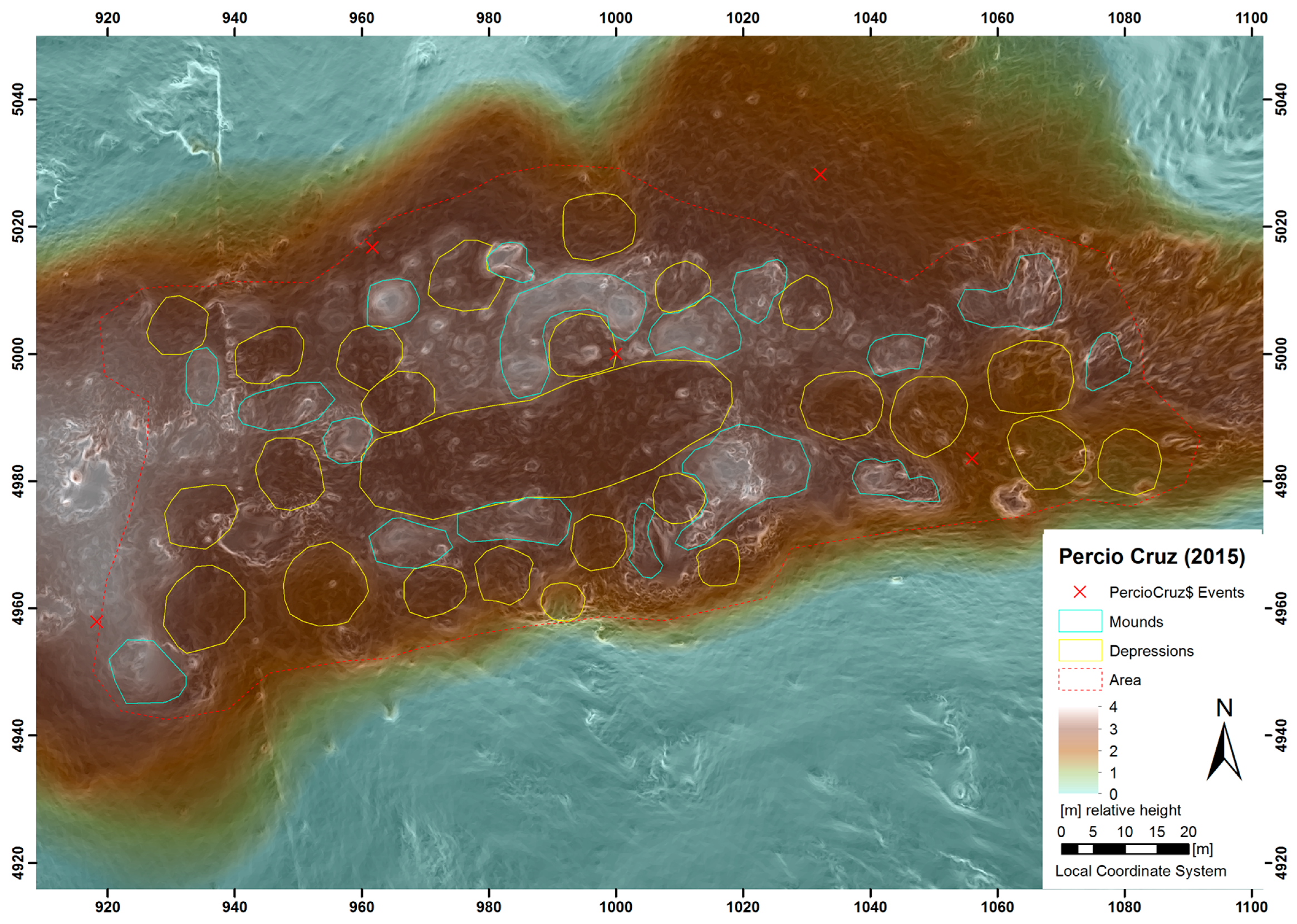
| Percio Cruz | 254,995 | 2,190,584 | 308 | 5 | 0.07 |
| Negrito | 279,470 | 2,195,037 | 350 | 4 | 0.06 |
| Laguna Grande | 282,502 | 2,195,516 | 356 | 5 | 0.07 |
| Chacuey | 230,707 | 2,158,124 | 206 | 5 | 0.03 |
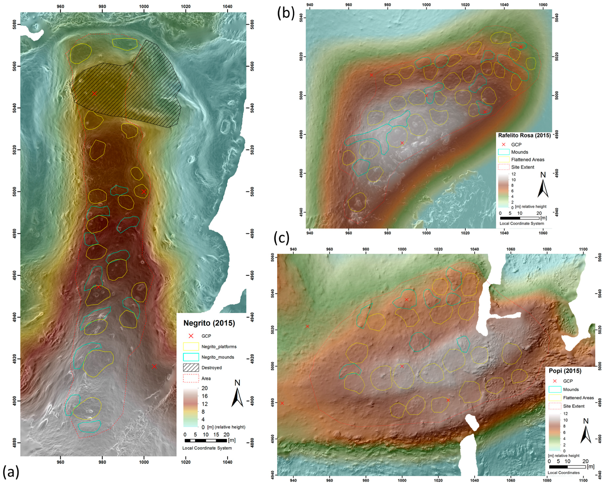
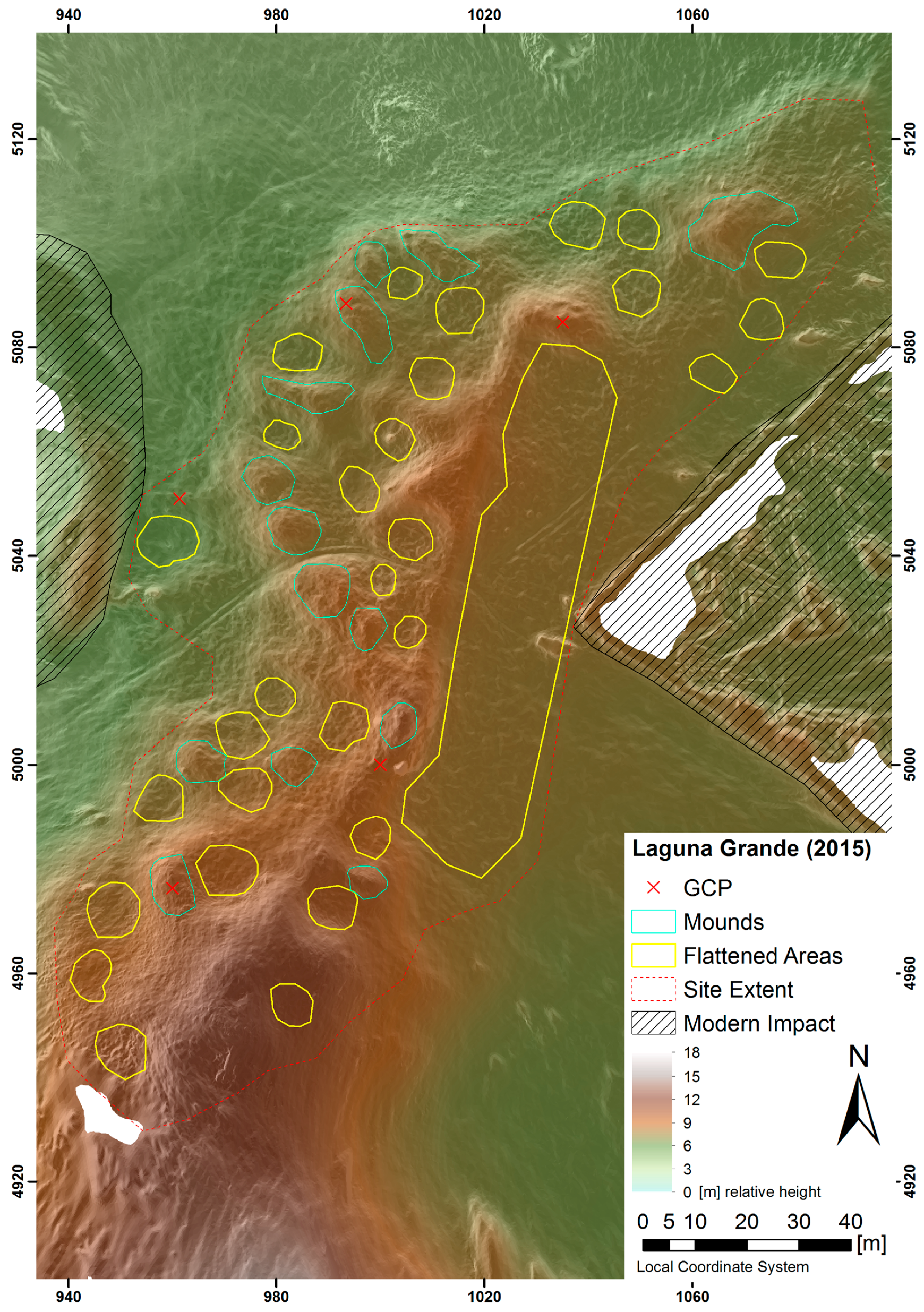
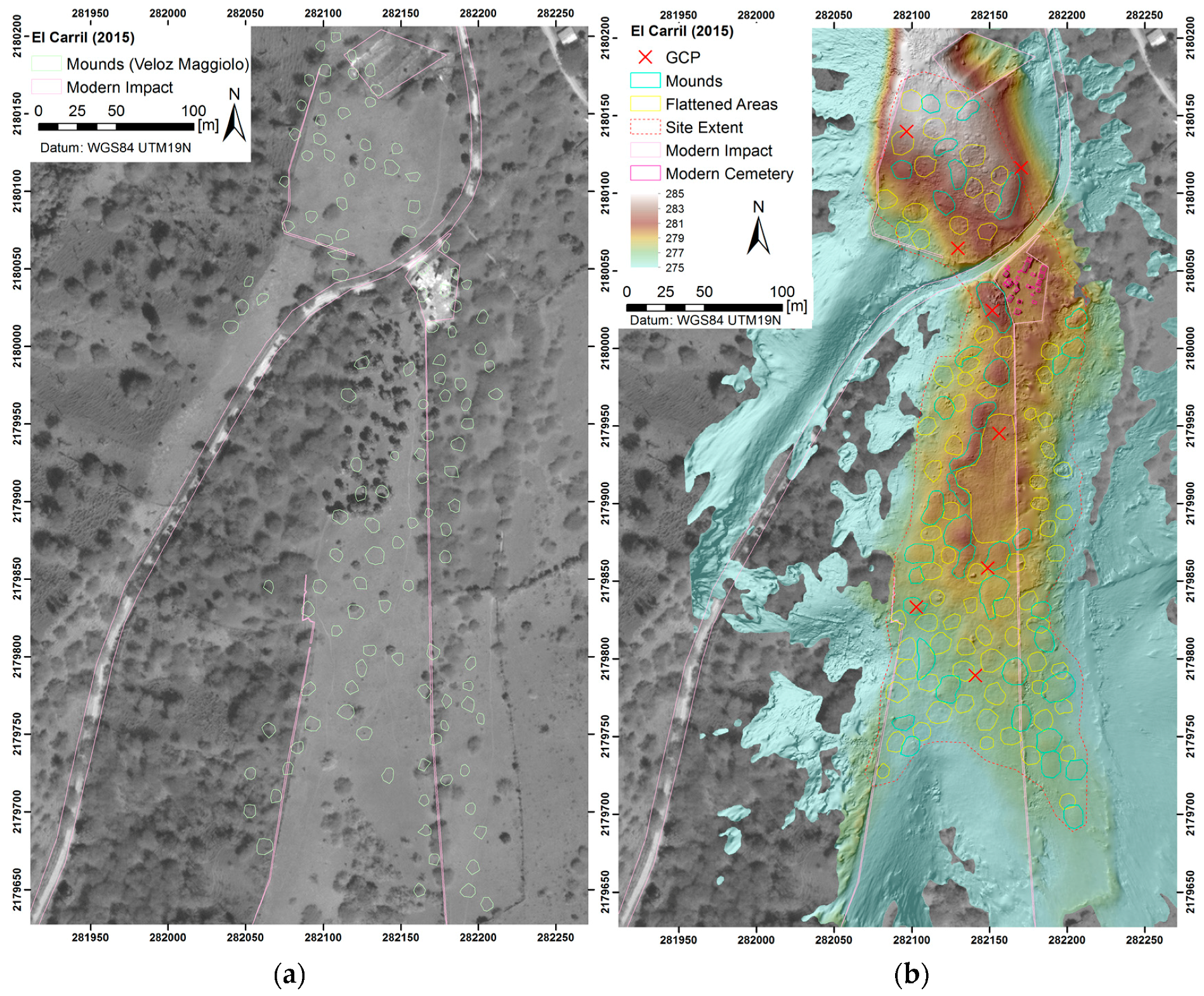
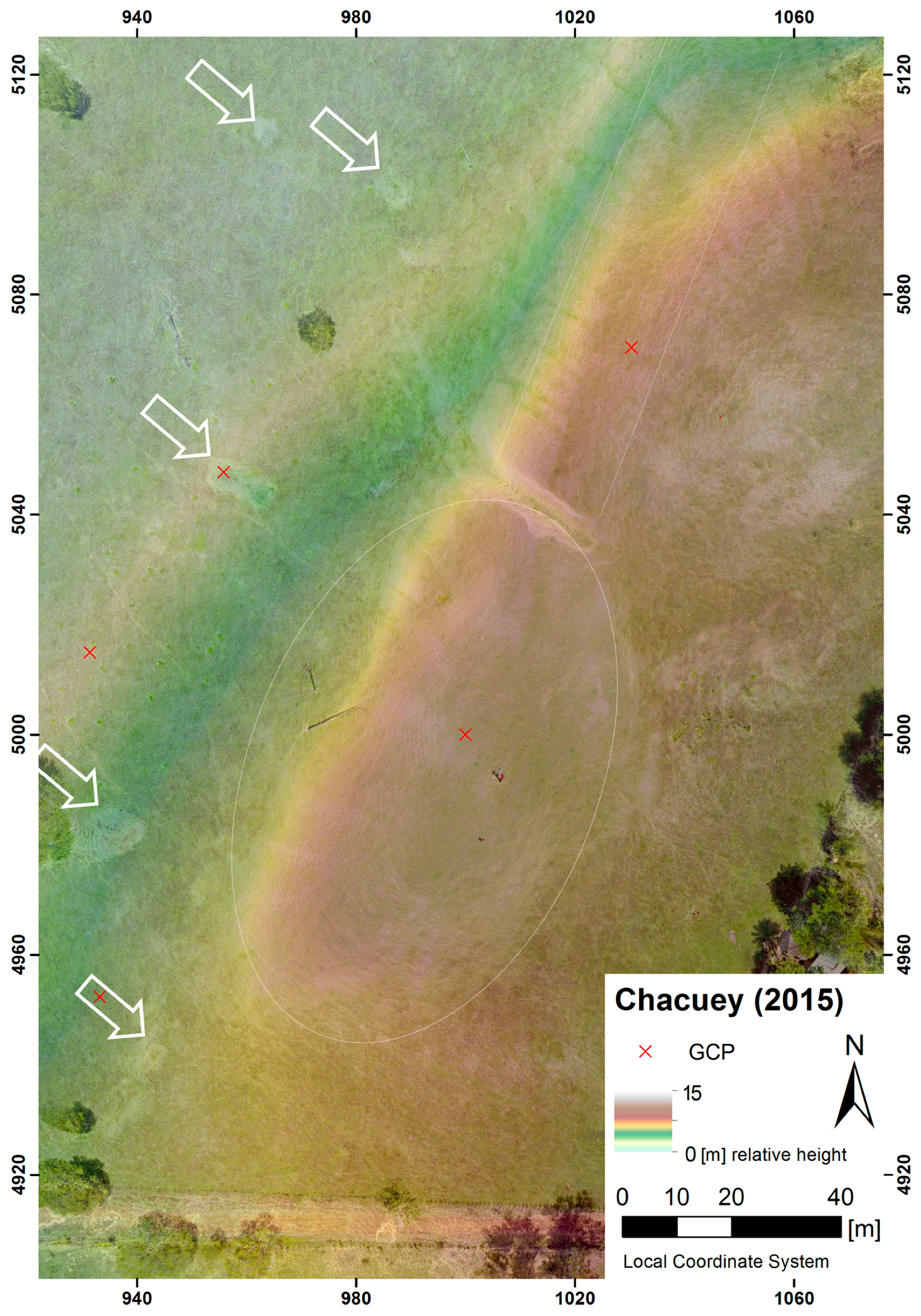
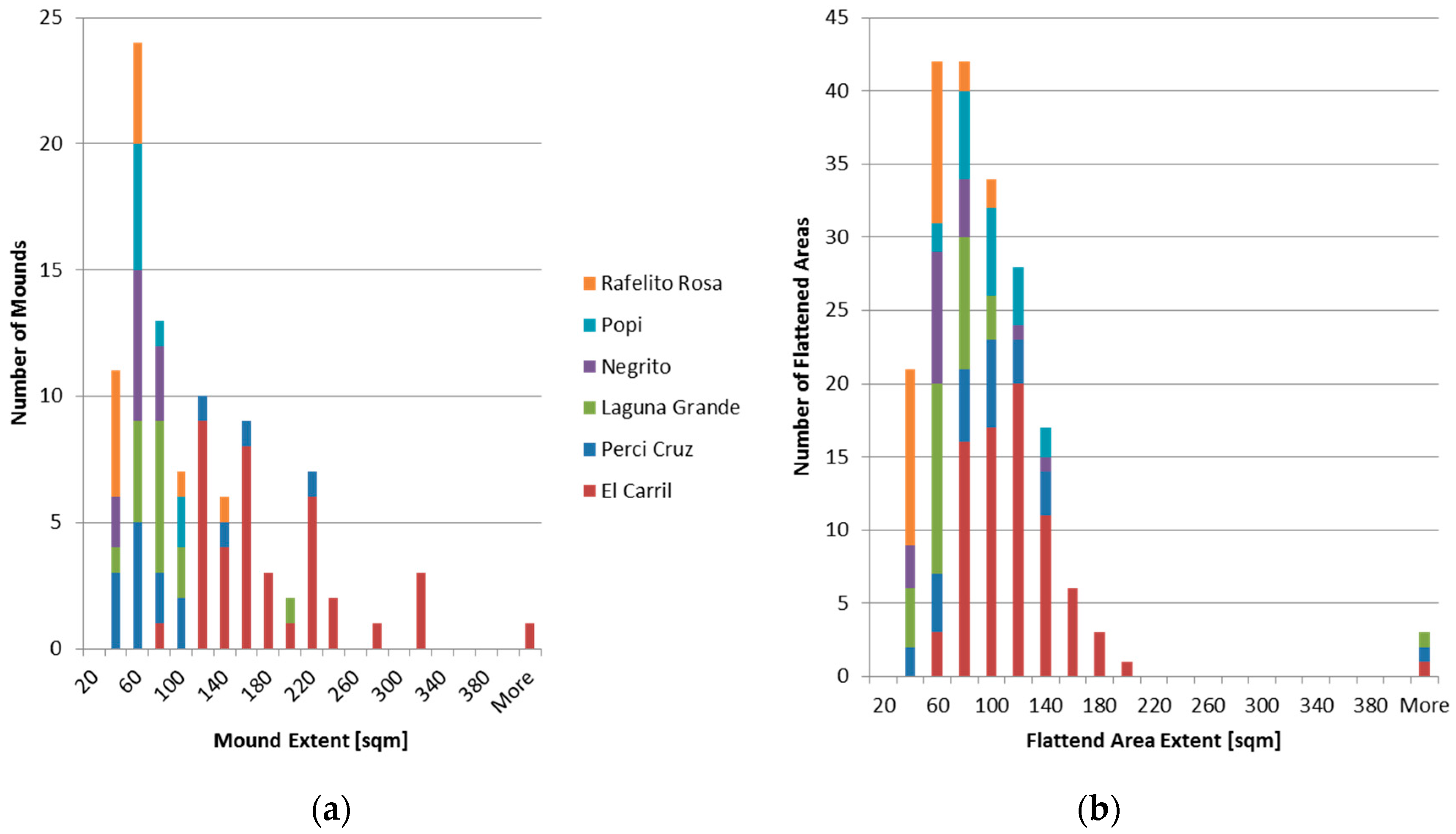
| Site Name | Altitude (m) | Estim. Settlem. Size (m2) | Distance from Sea (km) | Terrain | No. of Flattened Areas | No. of Mounds | Potential Central Plaza |
|---|---|---|---|---|---|---|---|
| El Flaco | 300 | / | 19.3 | Flank | Yes | Yes | No |
| El Manantial | 170 | 10,179 | 3,8 | flat | destroyed | 32 | unclear |
| El Carril | 300 | 44,582 | 17.5 | ridge | 78 | 42 | Yes |
| Laguna Gr. | 20 | 14,511 | 3.6 | flat | 30 | 14 | Yes |
| Percio Cruz | 200 | 9467 | 5.8 | ridge | 23 | 15 | Yes |
| Rafelito Rosa | 70 | 4519 | 1.2 | top | 28 | 11 | No |
| Negrito | 40 | 5478 | 2.0 | ridge | 17 | 11 | No |
| Popi | 70 | 8198 | 1.6 | top | 20 | 8 | No |
© 2016 by the authors; licensee MDPI, Basel, Switzerland. This article is an open access article distributed under the terms and conditions of the Creative Commons Attribution (CC-BY) license (http://creativecommons.org/licenses/by/4.0/).
Share and Cite
Sonnemann, T.F.; Ulloa Hung, J.; Hofman, C.L. Mapping Indigenous Settlement Topography in the Caribbean Using Drones. Remote Sens. 2016, 8, 791. https://doi.org/10.3390/rs8100791
Sonnemann TF, Ulloa Hung J, Hofman CL. Mapping Indigenous Settlement Topography in the Caribbean Using Drones. Remote Sensing. 2016; 8(10):791. https://doi.org/10.3390/rs8100791
Chicago/Turabian StyleSonnemann, Till F., Jorge Ulloa Hung, and Corinne L. Hofman. 2016. "Mapping Indigenous Settlement Topography in the Caribbean Using Drones" Remote Sensing 8, no. 10: 791. https://doi.org/10.3390/rs8100791
APA StyleSonnemann, T. F., Ulloa Hung, J., & Hofman, C. L. (2016). Mapping Indigenous Settlement Topography in the Caribbean Using Drones. Remote Sensing, 8(10), 791. https://doi.org/10.3390/rs8100791