
Land Surface Albedo Estimation from Chinese HJ Satellite Data Based on the Direct Estimation Approach


Abstract
:
1. Introduction
2. Data and Method
2.1. Chinese HJ Satellite Data

| HJ CCD | MODIS | ||
|---|---|---|---|
| Band No. | Spectral Range (µm) | Band No. | Spectral Range (µm) |
| 1 | 0.43–0.52 | 3 | 0.46–0.48 |
| 2 | 0.52–0.60 | 4 | 0.55–0.57 |
| 3 | 0.63–0.69 | 1 | 0.62–0.67 |
| 4 | 0.76–0.90 | 2 | 0.84–0.88 |
2.2. MODIS Surface BRDF Products
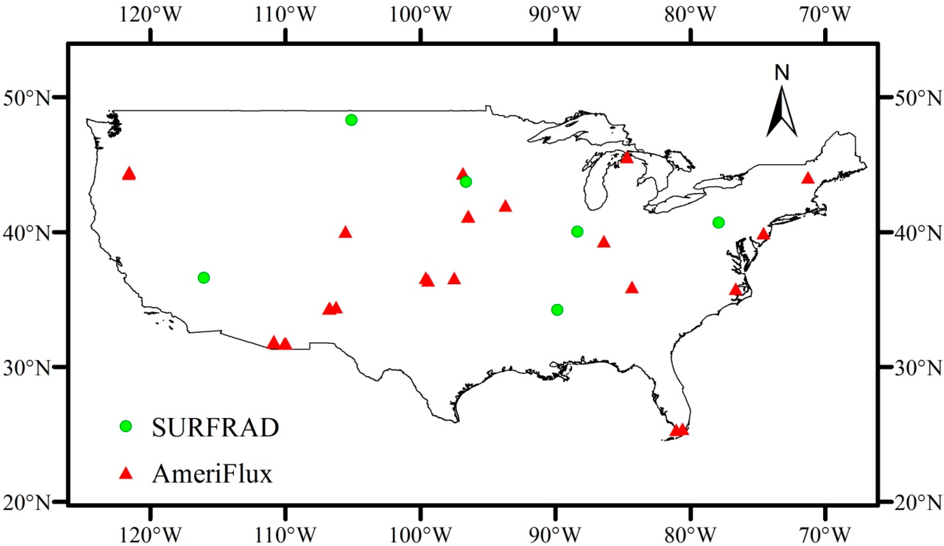
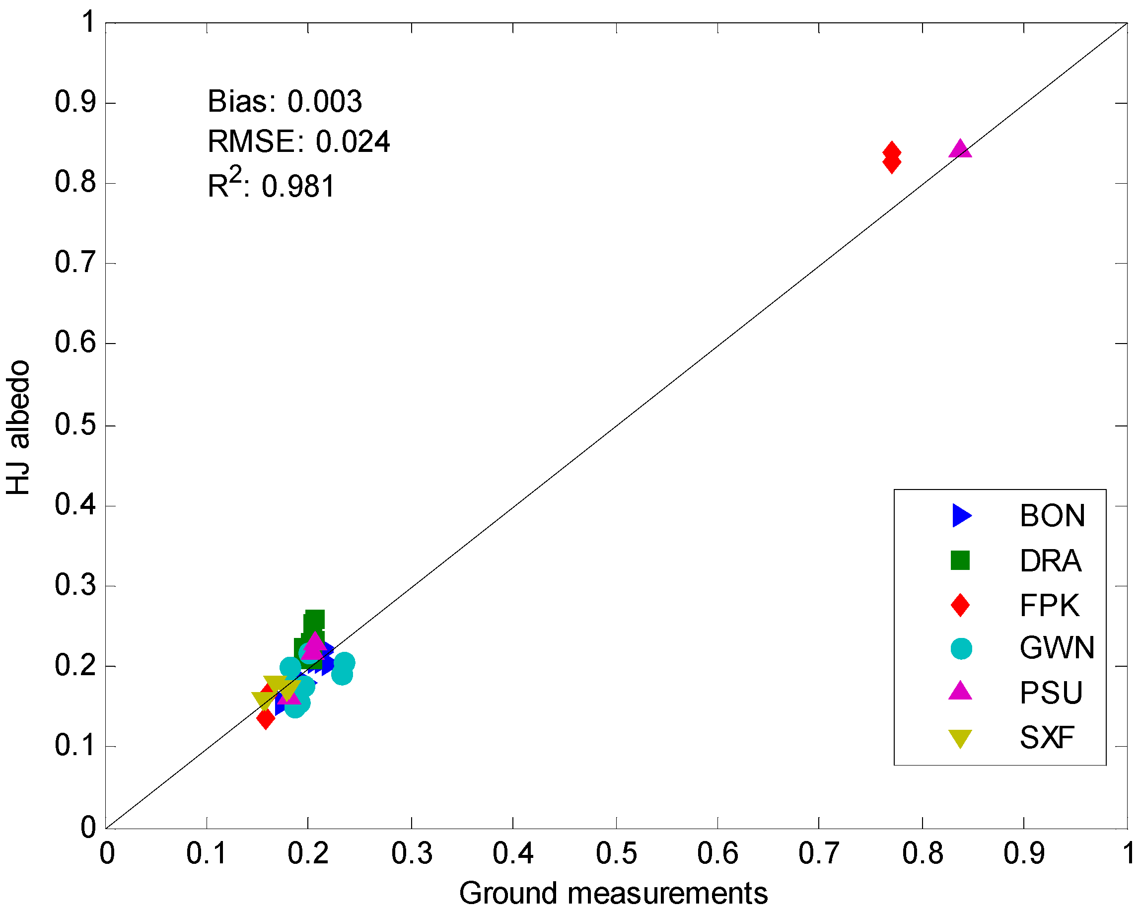
2.3. Flux Tower Measurements

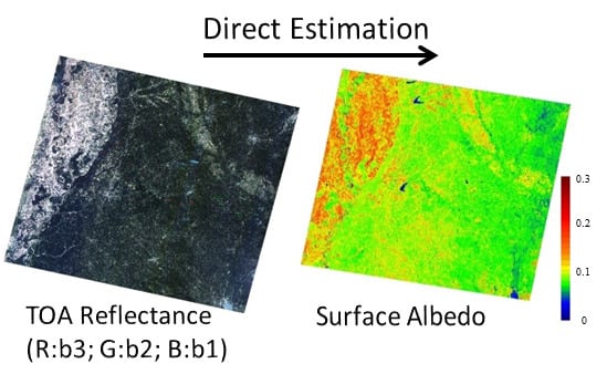
2.4. Albedo Direct Estimation
| Parameters | Values |
|---|---|
| Solar zenith angle | 0, 5, 10, 15, 20, 25, 30, 35, 40, 45, 50, 55, 60, 65, and 70 |
| View zenith angle | 0, 5, 10, 15, 20, 25, 30, and 35 |
| Relative azimuth angle | 0, 30, 60, 90, 120, 150, and 180 |
| Aerosol optical depth | 0.05, 0.10, 0.15, 0.20, 0.30, 0.40, and 0.60 |


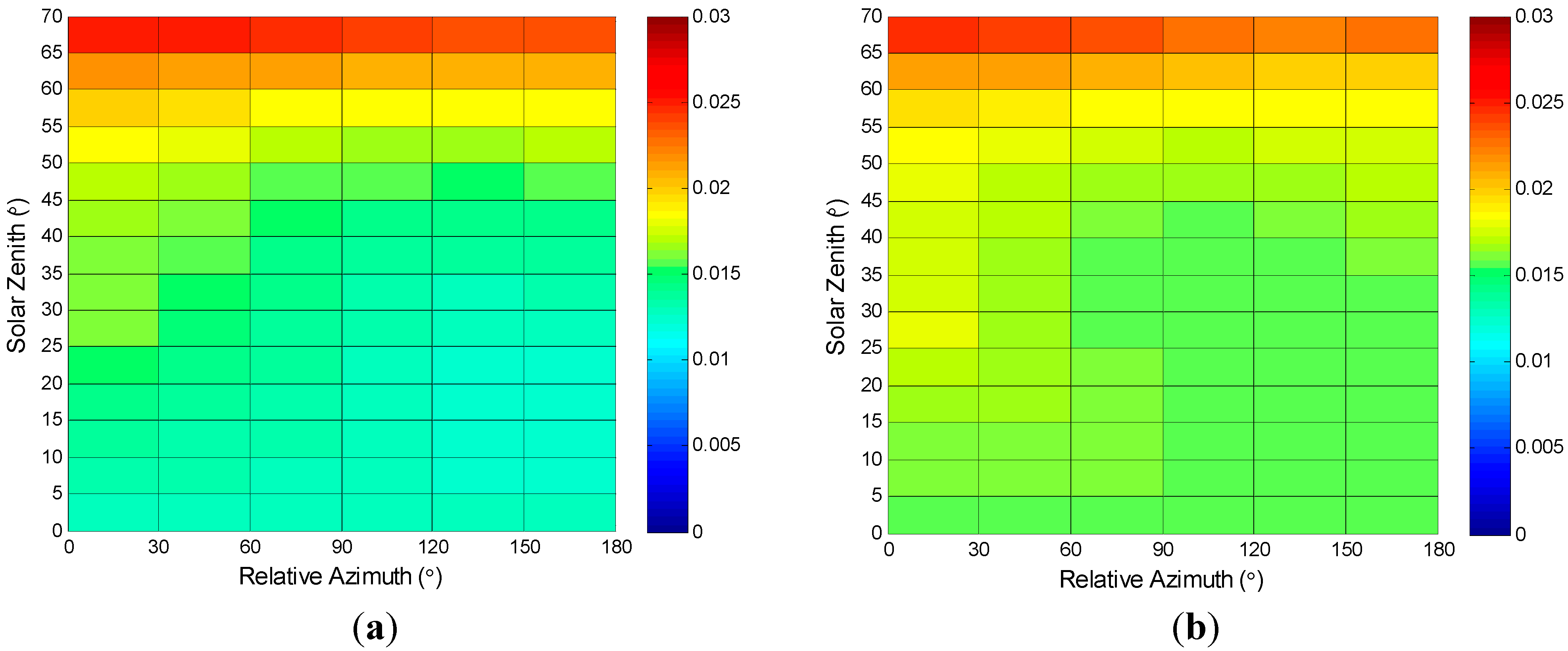
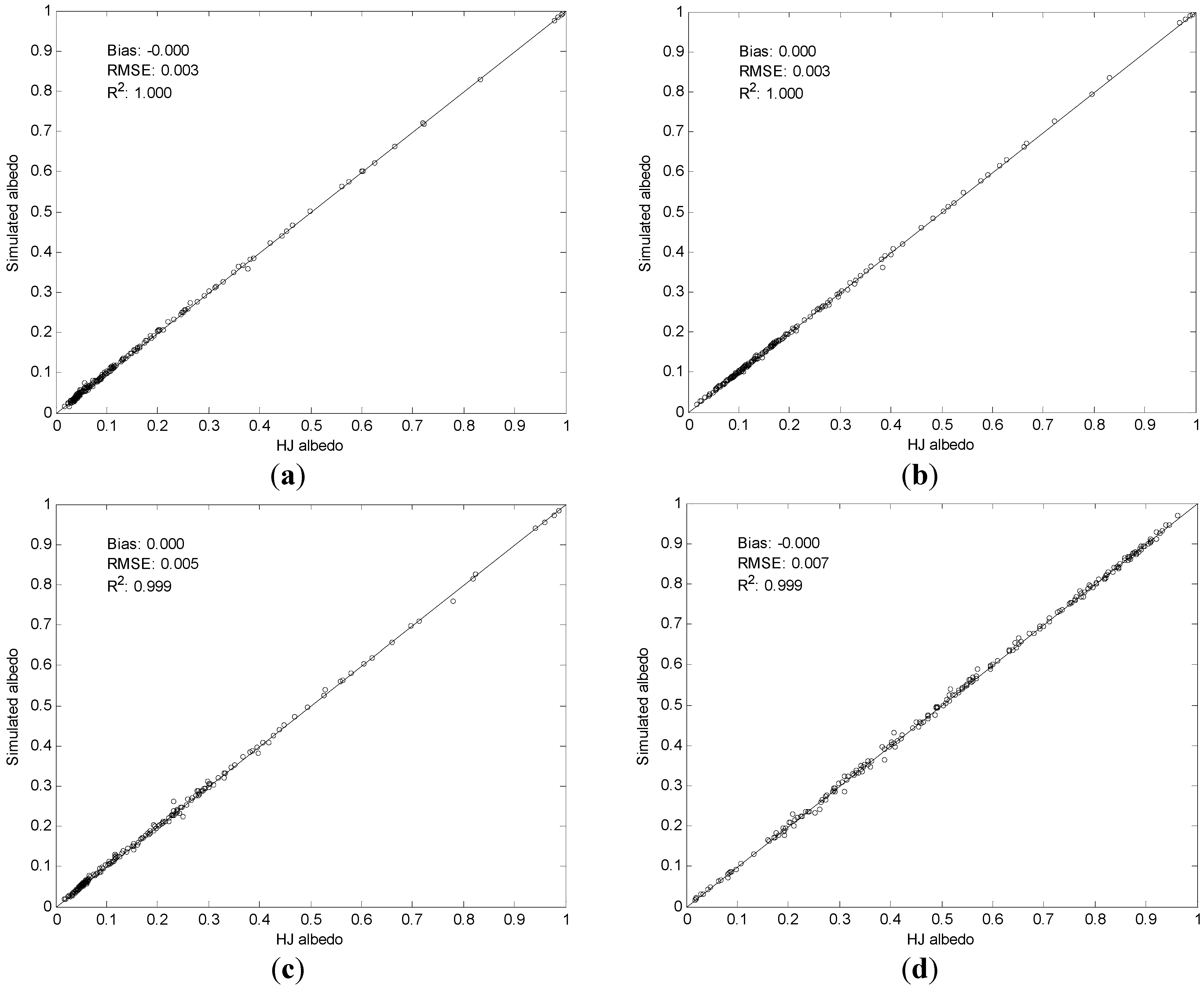
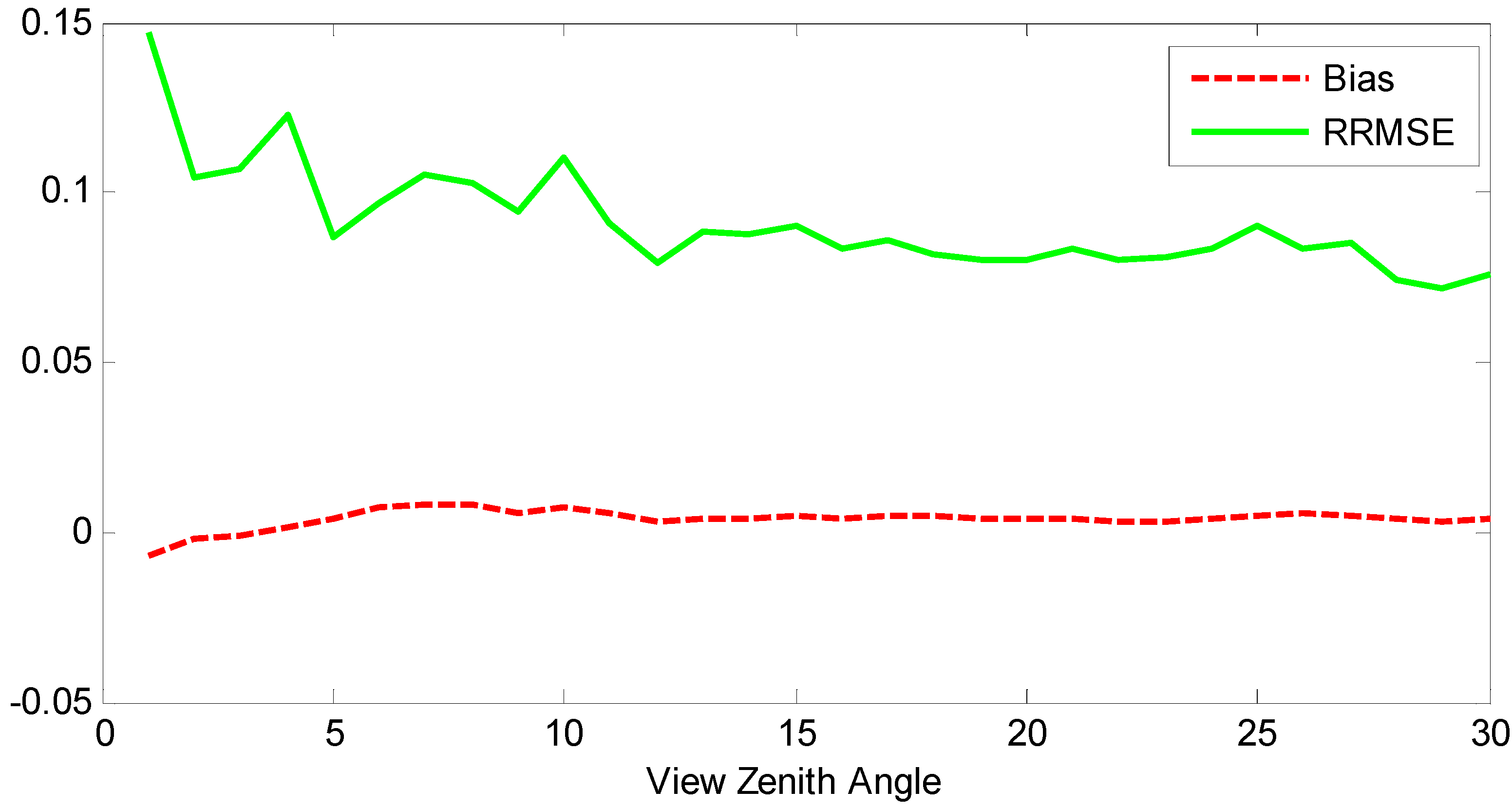
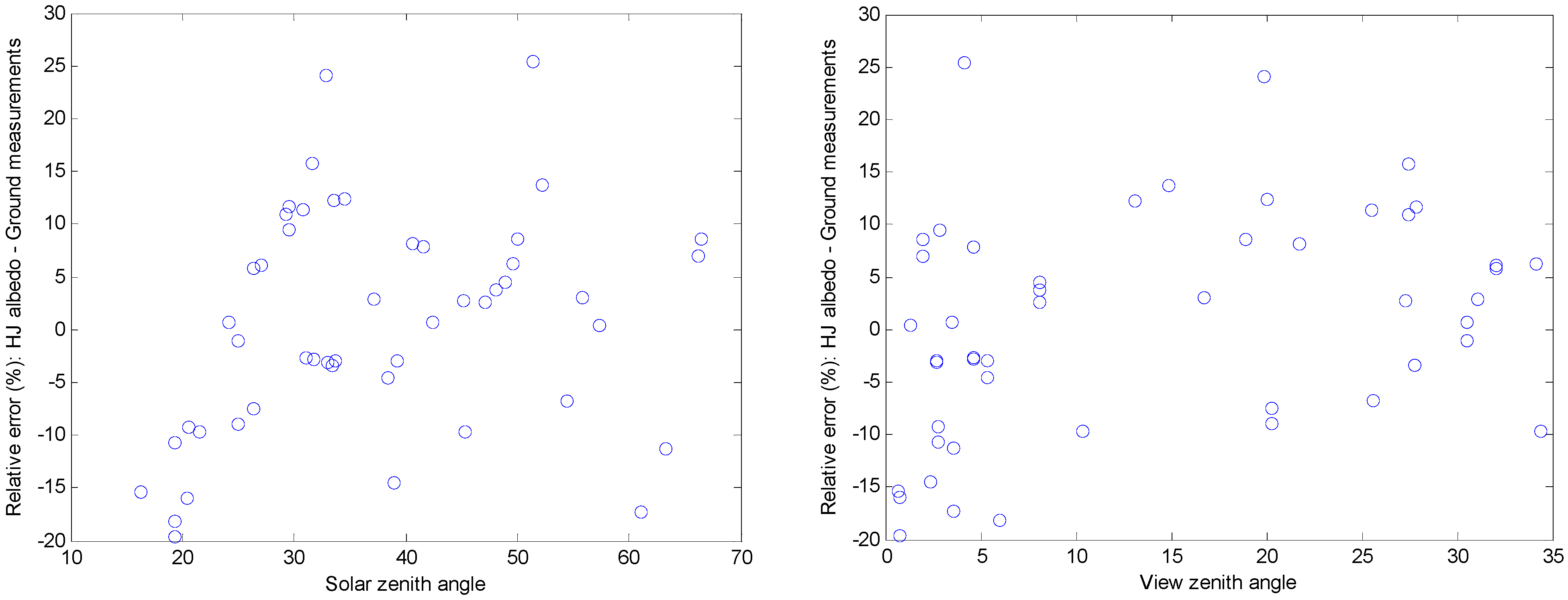
3. Results and Discussion
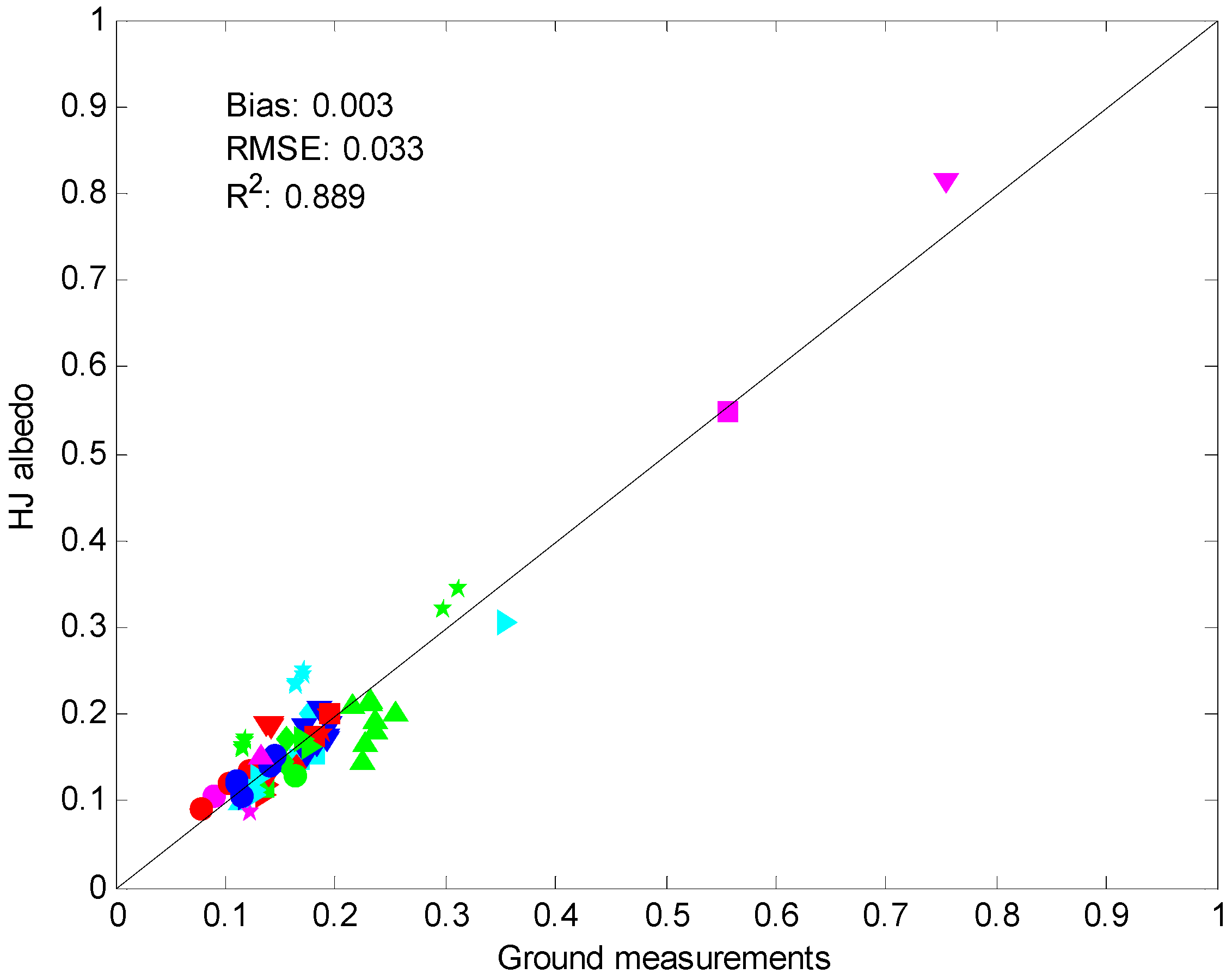
3.1. Validation against Ground Measurements


| Land Cover * | Mean | Standard Deviation | Bias | RMSE | N |
|---|---|---|---|---|---|
| DBF-ENF-EBF | 0.138 | 0.045 | 0.004 | 0.026 | 27 |
| GRA-CRO | 0.177 | 0.036 | −0.018 | 0.052 | 37 |
| OSH-WSV | 0.196 | 0.062 | 0.022 | 0.031 | 13 |
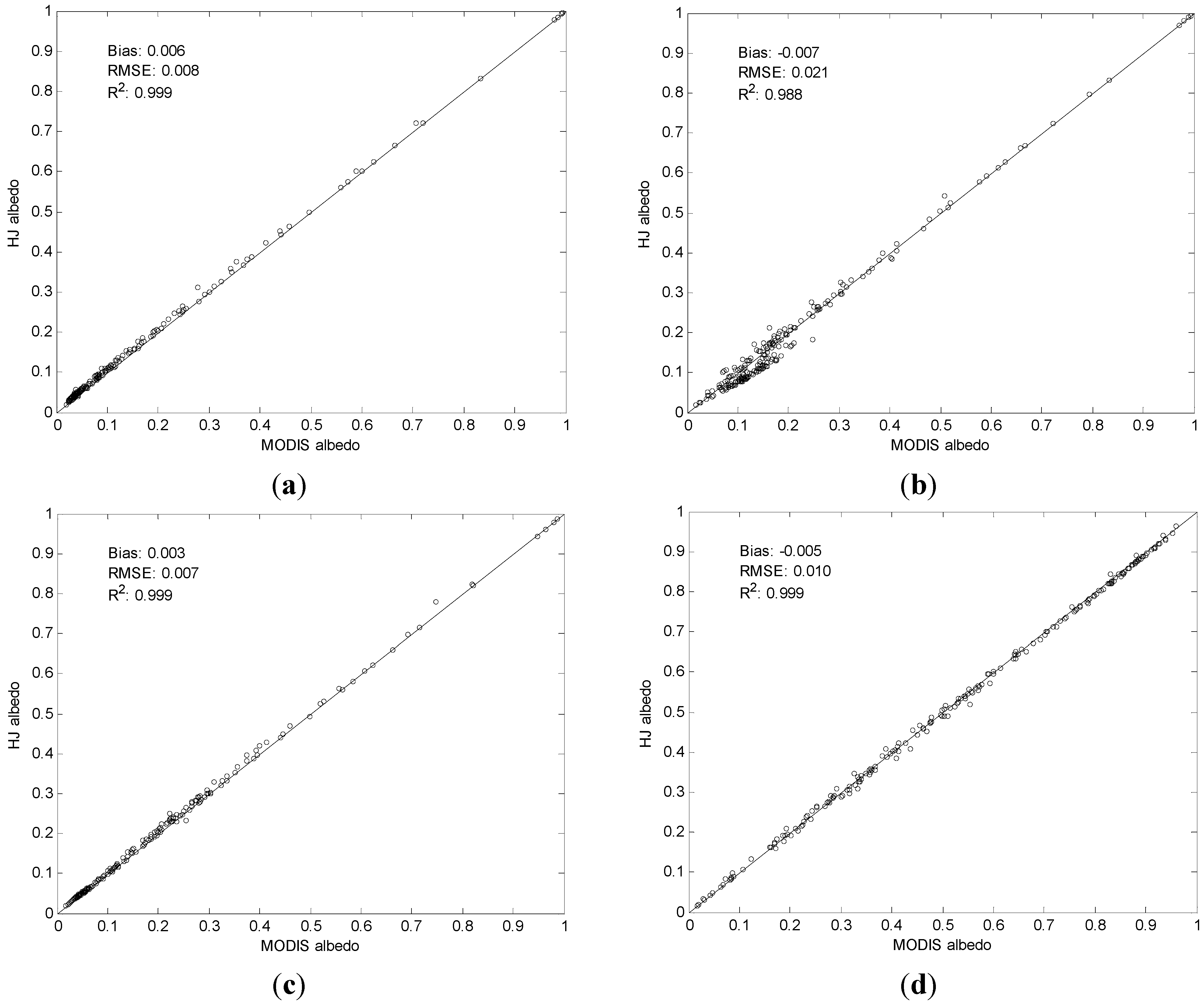
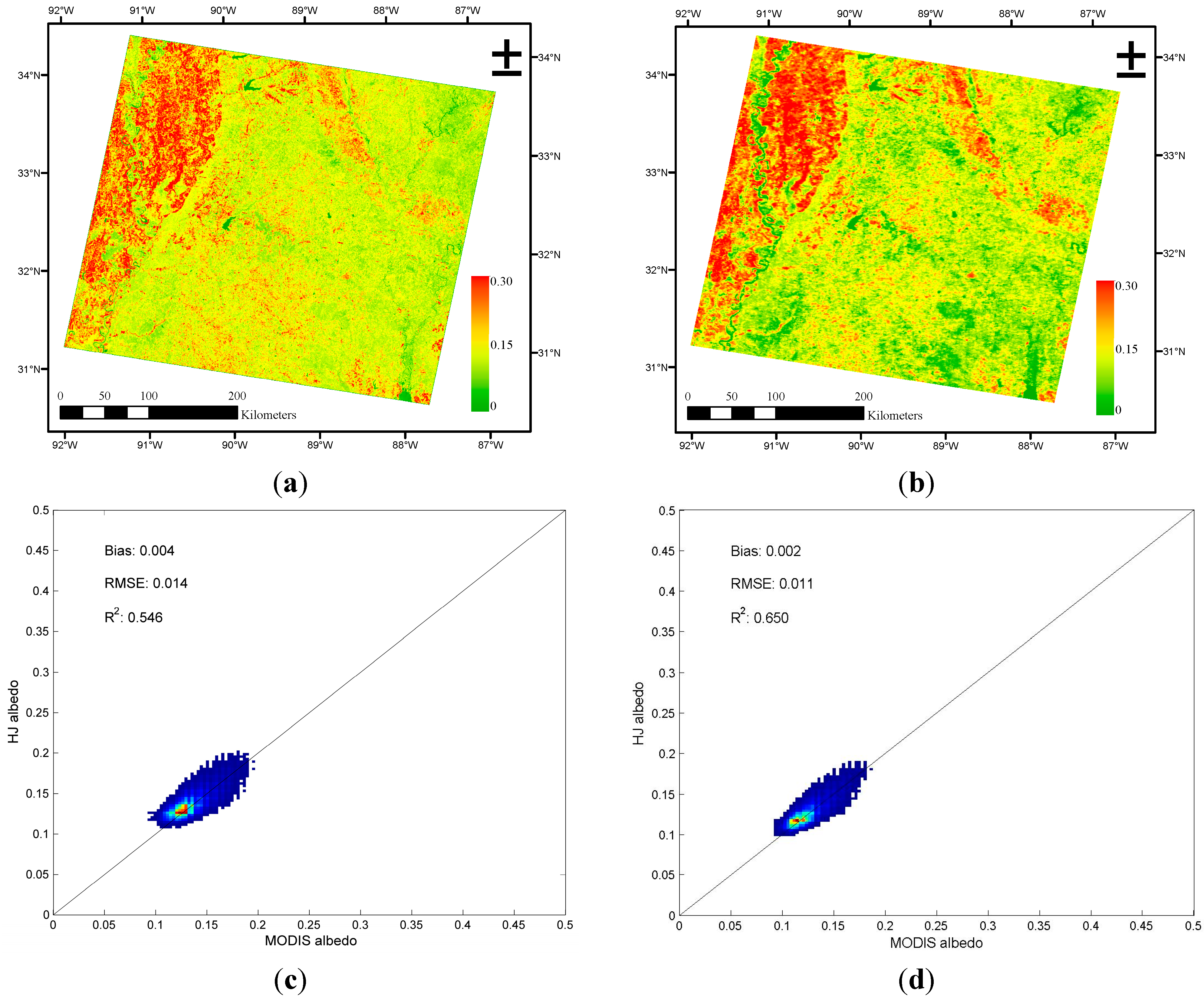
3.2. Comparison with MODIS Albedo Product


4. Summary and Conclusions
Acknowledgments
Author Contributions
Conflicts of Interest
References
- Gaffin, S.R.; Imhoff, M.; Rosenzweig, C.; Khanbilvardi, R.; Pasqualini, A.; Kong, A.Y.Y.; Grillo, D.; Freed, A.; Hillel, D.; Hartung, E.; et al. Bright is the new black-multi-year performance of high-albedo roofs in an urban climate. Environ. Res. Lett. 2012, 7. [Google Scholar] [CrossRef]
- Liang, S.L.; Zhang, X.; He, T.; Cheng, J.; Wang, D. Remote sensing of the land surface radiation budget. In Remote Sensing of Energy Fluxes and Soil Moisture Content; Petropoulos, G.P., Ed.; CRC Press: Boca Raton, FL, USA, 2013; pp. 125–165. [Google Scholar]
- Wild, M.; Folini, D.; Schar, C.; Loeb, N.; Dutton, E.G.; Konig-Langlo, G. The global energy balance from a surface perspective. Clim. Dyn. 2013, 40, 3107–3134. [Google Scholar] [CrossRef]
- He, T.; Liang, S.L.; Song, D.X. Analysis of global land surface albedo climatology and spatial-temporal variation during 1981–2010 from multiple satellite products. J. Geophys. Res.: Atmos. 2014, 119, 10281–10298. [Google Scholar] [CrossRef]
- Liang, S.L.; Wang, K.C.; Zhang, X.T.; Wild, M. Review on estimation of land surface radiation and energy budgets from ground measurement, remote sensing and model simulations. IEEE J. Sel. Top. Appl. Earth Obs. Remote Sens. 2010, 3, 225–240. [Google Scholar] [CrossRef]
- Roman, M.O.; Gatebe, C.K.; Shuai, Y.; Wang, Z.; Gao, F.; Masek, J.G.; He, T.; Liang, S.; Schaaf, C.B. Use of in situ and airborne multiangle data to assess MODIS- and Landsat-based estimates of directional reflectance and albedo. IEEE Trans. Geosci. Remote Sens. 2013, 51, 1393–1404. [Google Scholar] [CrossRef]
- Roman, M.O.; Gatebe, C.K.; Schaaf, C.B.; Poudyal, R.; Wang, Z.S.; King, M.D. Variability in surface brdf at different spatial scales (30 m–500 m) over a mixed agricultural landscape as retrieved from airborne and satellite spectral measurements. Remote Sens. Environ. 2011, 115, 2184–2203. [Google Scholar] [CrossRef]
- Kuusinen, N.; Lukes, P.; Stenberg, P.; Levula, J.; Nikinmaa, E.; Berninger, F. Measured and modelled albedos in finnish boreal forest stands of different species, structure and understory. Ecol. Model. 2014, 284, 10–18. [Google Scholar] [CrossRef]
- Vanderhoof, M.; Williams, C.A.; Shuai, Y.; Jarvis, D.; Kulakowski, D.; Masek, J. Albedo-induced radiative forcing from mountain pine beetle outbreaks in forests, south-central rocky mountains: Magnitude, persistence, and relation to outbreak severity. Biogeosciences 2014, 11, 563–575. [Google Scholar] [CrossRef]
- Kuusinen, N.; Tomppo, E.; Shuai, Y.; Berninger, F. Effects of forest age on albedo in boreal forests estimated from MODIS and Landsat Albedo retrievals. Remote Sens. Environ. 2014, 145, 145–153. [Google Scholar] [CrossRef]
- Gao, F.; He, T.; Masek, J.G.; Shuai, Y.M.; Schaaf, C.B.; Wang, Z.S. Angular effects and correction for medium resolution sensors to support crop monitoring. IEEE J. Sel. Top. Appl. Earth Obs. Remote Sens. 2014, 7, 4480–4489. [Google Scholar] [CrossRef]
- Zhou, Y.Y.; Weng, Q.H.; Gurney, K.R.; Shuai, Y.M.; Hu, X.F. Estimation of the relationship between remotely sensed anthropogenic heat discharge and building energy use. ISPRS J. Photogramm. Remote Sens. 2012, 67, 65–72. [Google Scholar] [CrossRef]
- Roberts, D.A.; Quattrochi, D.A.; Hulley, G.C.; Hook, S.J.; Green, R.O. Synergies between vswir and tir data for the urban environment: An evaluation of the potential for the hyperspectral infrared imager (HYSPIRI) decadal survey mission. Remote Sens. Environ. 2012, 117, 83–101. [Google Scholar] [CrossRef]
- Jiang, B.; Liang, S.L.; Townshend, J.R.; Dodson, Z.M. Assessment of the radiometric performance of Chinese HJ-1 satellite ccd instruments. IEEE J. Sel. Top. Appl. Earth Obs. Remote Sens. 2013, 6, 840–850. [Google Scholar] [CrossRef]
- Wang, Z.; Xiao, P.F.; Gu, X.F.; Feng, X.Z.; Li, X.Y.; Gao, H.L.; Li, H.; Lin, J.T.; Zhang, X.L. Uncertainty analysis of cross-calibration for HJ-1 CCD camera. Sci. China Technol. Sci. 2013, 56, 713–723. [Google Scholar] [CrossRef]
- Zhang, X.; Zhao, X.; Liu, G.D.; Kang, Q.; Wu, D.H. Radioactive quality evaluation and cross validation of data from the HJ-1A/B satellites’ CCD sensors. Sensors 2013, 13, 8564–8576. [Google Scholar] [CrossRef] [PubMed]
- Chen, W.; Cao, C.X.; He, Q.S.; Guo, H.D.; Zhang, H.; Li, R.Q.; Zheng, S.; Xu, M.; Gao, M.X.; Zhao, J.A.; et al. Quantitative estimation of the Shrub canopy LAI from atmosphere-corrected HJ-1 CCD data in MU US sandland. Sci. China Earth Sci. 2010, 53, 26–33. [Google Scholar] [CrossRef]
- Sun, L.; Sun, C.K.; Liu, Q.H.; Zhong, B. Aerosol optical depth retrieval by HJ-1/CCD supported by MODIS surface reflectance data. Sci. China Earth Sci. 2010, 53, 74–80. [Google Scholar] [CrossRef]
- Zhang, M.W.; Tang, J.W.; Dong, Q.; Duan, H.T.; Shen, Q. Atmospheric correction of HJ-1 CCD imagery over turbid lake waters. Opt. Express 2014, 22, 7906–7924. [Google Scholar] [CrossRef] [PubMed]
- Li, Y.J.; Xue, Y.; He, X.W.; Guang, J. High-resolution aerosol remote sensing retrieval over urban areas by synergetic use of HJ-1 CCD and MODIS data. Atmos. Environ. 2012, 46, 173–180. [Google Scholar]
- Wu, H.; Liang, S.L.; Tong, L.; He, T.; Yu, Y. Bidirectional reflectance for multiple snow-covered land types from MISR products. IEEE Geosci. Remote Sens. Lett. 2012, 9, 994–998. [Google Scholar] [CrossRef]
- Shuai, Y.M.; Masek, J.G.; Gao, F.; Schaaf, C.B. An algorithm for the retrieval of 30-m snow-free Albedo from Landsat surface reflectance and MODIS BRDF. Remote Sens. Environ. 2011, 115, 2204–2216. [Google Scholar] [CrossRef]
- Shuai, Y.M.; Masek, J.G.; Gao, F.; Schaaf, C.B.; He, T. An approach for the long-term 30-m land surface snow-free albedo retrieval from historic landsat surface reflectance and MODIS-based a priori anisotropy knowledge. Remote Sens. Environ. 2014, 152, 467–479. [Google Scholar] [CrossRef]
- He, T.; Liang, S.L.; Wang, D.; Shi, Q.; Tao, X. Estimation of high-resolution land surface shortwave Albedo from Aviris data. IEEE J. Sel. Top. Appl. Earth Obs. Remote Sens. 2014, 7, 4919–4928. [Google Scholar] [CrossRef]
- Schaaf, C.B.; Gao, F.; Strahler, A.H.; Lucht, W.; Li, X.W.; Tsang, T.; Strugnell, N.C.; Zhang, X.Y.; Jin, Y.F.; Muller, J.P.; et al. First operational Brdf, Albedo Nadir reflectance products from MODIS. Remote Sens. Environ. 2002, 83, 135–148. [Google Scholar] [CrossRef]
- Franch, B.; Vermote, E.F.; Claverie, M. Intercomparison of landsat albedo retrieval techniques and evaluation against in situ measurements across the us surfrad network. Remote Sens. Environ. 2014, 152, 627–637. [Google Scholar] [CrossRef]
- Gao, B.; Jia, L.; Wang, T.X. Derivation of land surface albedo at high resolution by combining HJ-1A/B reflectance observations with MODIS BRDF products. Remote Sens. 2014, 6, 8966–8985. [Google Scholar] [CrossRef]
- He, T.; Liang, S.L.; Wang, D.; Wu, H.; Yu, Y.; Wang, J. Estimation of surface albedo and directional reflectance from moderate resolution imaging spectroradiometer (MODIS) observations. Remote Sens. Environ. 2012, 119, 286–300. [Google Scholar] [CrossRef]
- Wang, D.; Liang, S.L.; He, T.; Yu, Y. Direct estimation of land surface albedo from VIIRS data: Algorithm improvement and preliminary validation. J. Geophys. Res.: Atmos. 2013, 118, 12577–12586. [Google Scholar] [CrossRef]
- Lucht, W.; Schaaf, C.B.; Strahler, A.H. An algorithm for the retrieval of Albedo from space using semiempirical BRDF models. IEEE Trans. Geosci. Remote Sens. 2000, 38, 977–998. [Google Scholar] [CrossRef]
- He, T.; Liang, S.L.; Wang, D.; Shuai, Y.; Yu, Y. Fusion of satellite land surface albedo products across scales using a multiresolution tree method in the north central United States. IEEE Trans. Geosci. Remote Sens. 2014, 52, 3428–3439. [Google Scholar] [CrossRef]
- Wang, Z.S.; Schaaf, C.B.; Strahler, A.H.; Chopping, M.J.; Roman, M.O.; Shuai, Y.M.; Woodcock, C.E.; Hollinger, D.Y.; Fitzjarrald, D.R. Evaluation of MODIS Albedo product (MCD43A) over grassland, agriculture and forest surface types during dormant and snow-covered periods. Remote Sens. Environ. 2014, 140, 60–77. [Google Scholar] [CrossRef]
- Liang, S.L.; Strahler, A.H.; Walthall, C. Retrieval of land surface albedo from satellite observations: A simulation study. J. Appl. Meteorol. 1999, 38, 712–725. [Google Scholar] [CrossRef]
- Vermote, E.F.; Tanre, D.; Deuze, J.L.; Herman, M.; Morcrette, J.J. Second Simulation of the Satellite Signal in the Solar Spectrum, 6S: An overview. IEEE Trans. Geosci. Remote Sens. 1997, 35, 675–686. [Google Scholar] [CrossRef]
- He, T.; Liang, S.L.; Wang, D. Direct estimation of land surface Albedo from simultaneous multi-angle MISR data. Remote Sens. Environ. 2015. submitted. [Google Scholar]
- Wang, D.; Liang, S.L.; He, T.; Yu, Y.; Schaaf, C.; Wang, Z. Estimating daily mean land surface albedo from MODIS data. J. Geophys. Res.: Atmos. 2015. submitted. [Google Scholar]
- Cescatti, A.; Marcolla, B.; Vannan, S.K.S.; Pan, J.Y.; Roman, M.O.; Yang, X.Y.; Ciais, P.; Cook, R.B.; Law, B.E.; Matteucci, G.; et al. Intercomparison of MODIS albedo retrievals and in situ measurements across the global fluxnet network. Remote Sens. Environ. 2012, 121, 323–334. [Google Scholar] [CrossRef]
- Jin, S.M.; Yang, L.M.; Danielson, P.; Homer, C.; Fry, J.; Xian, G. A comprehensive change detection method for updating the national land cover database to circa 2011. Remote Sens. Environ. 2013, 132, 159–175. [Google Scholar] [CrossRef]
© 2015 by the authors; licensee MDPI, Basel, Switzerland. This article is an open access article distributed under the terms and conditions of the Creative Commons Attribution license (http://creativecommons.org/licenses/by/4.0/).
Share and Cite
He, T.; Liang, S.; Wang, D.; Chen, X.; Song, D.-X.; Jiang, B. Land Surface Albedo Estimation from Chinese HJ Satellite Data Based on the Direct Estimation Approach. Remote Sens. 2015, 7, 5495-5510. https://doi.org/10.3390/rs70505495
He T, Liang S, Wang D, Chen X, Song D-X, Jiang B. Land Surface Albedo Estimation from Chinese HJ Satellite Data Based on the Direct Estimation Approach. Remote Sensing. 2015; 7(5):5495-5510. https://doi.org/10.3390/rs70505495
Chicago/Turabian StyleHe, Tao, Shunlin Liang, Dongdong Wang, Xiaona Chen, Dan-Xia Song, and Bo Jiang. 2015. "Land Surface Albedo Estimation from Chinese HJ Satellite Data Based on the Direct Estimation Approach" Remote Sensing 7, no. 5: 5495-5510. https://doi.org/10.3390/rs70505495
APA StyleHe, T., Liang, S., Wang, D., Chen, X., Song, D.-X., & Jiang, B. (2015). Land Surface Albedo Estimation from Chinese HJ Satellite Data Based on the Direct Estimation Approach. Remote Sensing, 7(5), 5495-5510. https://doi.org/10.3390/rs70505495