
Optimal Nodes Selectiveness from WSN to Fit Field Scale Albedo Observation and Validation in Long Time Series in the Foci Experiment Areas, Heihe

 ,
,
Abstract
:
1. Introduction
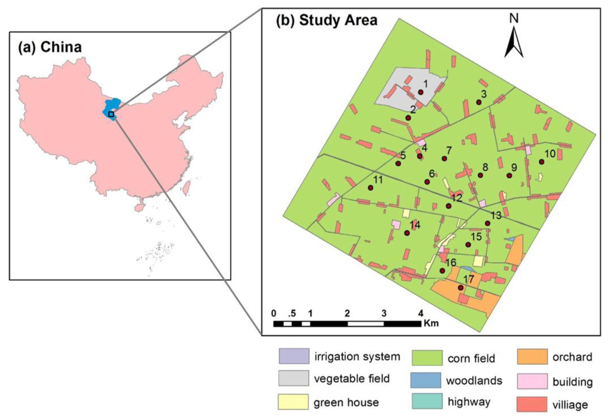
2. Study Area and Datasets


| Node | Lat | Lon | Elev (m) | Landcover | Measurement Period |
|---|---|---|---|---|---|
| 1 | 100.35813 | 38.89322 | 1552.75 | vegetable field | 10 June 2012 10:30 a.m.–17 September 2012 9:10 a.m. |
| 2 | 100.35406 | 38.88695 | 1559.09 | cornfield | 3 May 2012 1:50 p.m.–21 September 2012 3:00 p.m. |
| 3 | 100.37634 | 38.89053 | 1543.05 | cornfield | 3 June 2012 5:10 p.m.–18 September 2012 2:50 p.m. |
| 4 | 100.35753 | 38.87752 | 1561.87 | building | 10 May 2012 8:10 a.m.–17 September 8:50 a.m. |
| 5 | 100.35068 | 38.87574 | 1567.65 | cornfield | 4 June 2012 10:30 a.m.–18 September 2012 9:00 a.m. |
| 6 | 100.3597 | 38.87116 | 1562.97 | cornfield | 9 May 2012 5:50 p.m.–21 September 2012 5:30 p.m. |
| 7 | 100.36521 | 38.87676 | 1556.39 | cornfield | 28 May 2012 5:10 p.m.–18 September 2012 2:40 p.m. |
| 8 | 100.37649 | 38.87254 | 1550.06 | cornfield | 14 May 2012 3:20 a.m.–21 September 2012 8:50 a.m. |
| 9 | 100.38546 | 38.87239 | 1543.34 | cornfield | 4 June 2012 7:10 p.m.–17 September 2012 5:20 p.m. |
| 10 | 100.39572 | 38.87567 | 1534.73 | cornfield | 1 June 2012 12:00 a.m.–17 September 2012 2:50 p.m. |
| 11 | 100.34197 | 38.86991 | 1575.65 | cornfield | 2 June 2012 6:20 p.m.–18 September 2012 9:00 a.m. |
| 12 | 100.36631 | 38.86515 | 1559.25 | cornfield | 10 May 2012 10:40 a.m.–21 September 2012 2:50 p.m. |
| 13 | 100.37852 | 38.86074 | 1550.73 | cornfield | 6 May 2012 4:30 p.m.–20 September 2012 2:50 p.m. |
| 14 | 100.3531 | 38.85867 | 1570.23 | cornfield | 6 May 2012 5:40 p.m.–21 September 2012 8:50 a.m. |
| 15 | 100.37225 | 38.85557 | 1559.0 | cornfield | 10 May 2012 10:40 a.m.–26 September 2012 0:50 p.m. |
| 16 | 100.36411 | 38.84931 | 1564.31 | cornfield | 1 June 2012 0:00 a.m.–17 September 2012 4:50 p.m. |
| 17 | 100.36972 | 38.8451 | 1559.63 | orchard | 12 May 2012 9:50 a.m.–17 September 2012 2:30 p.m. |
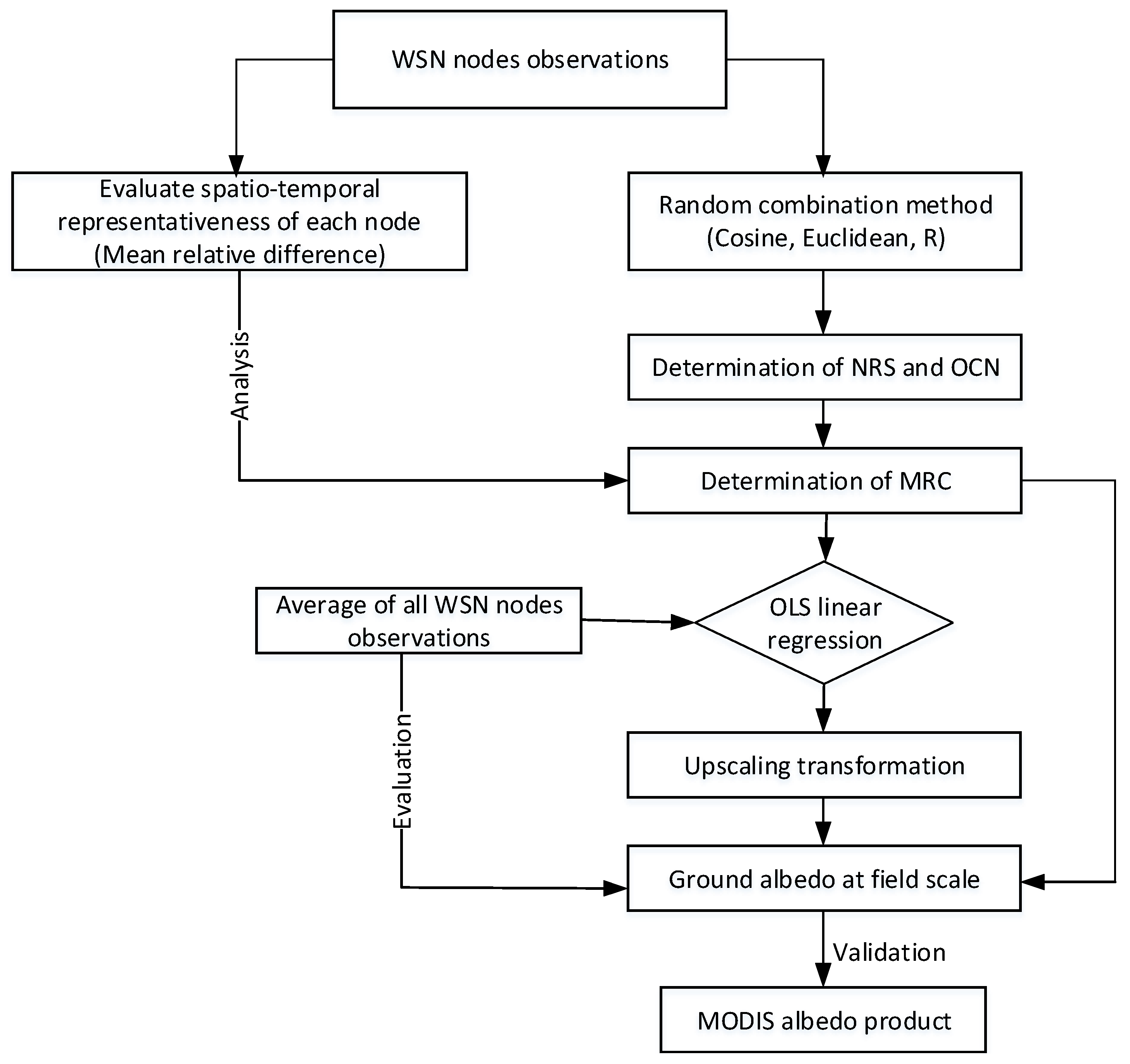
3. Methods

3.1. Spatiotemporal Characteristics and Assessment of Spatiotemporal Representativeness
3.2. Random Combination Method
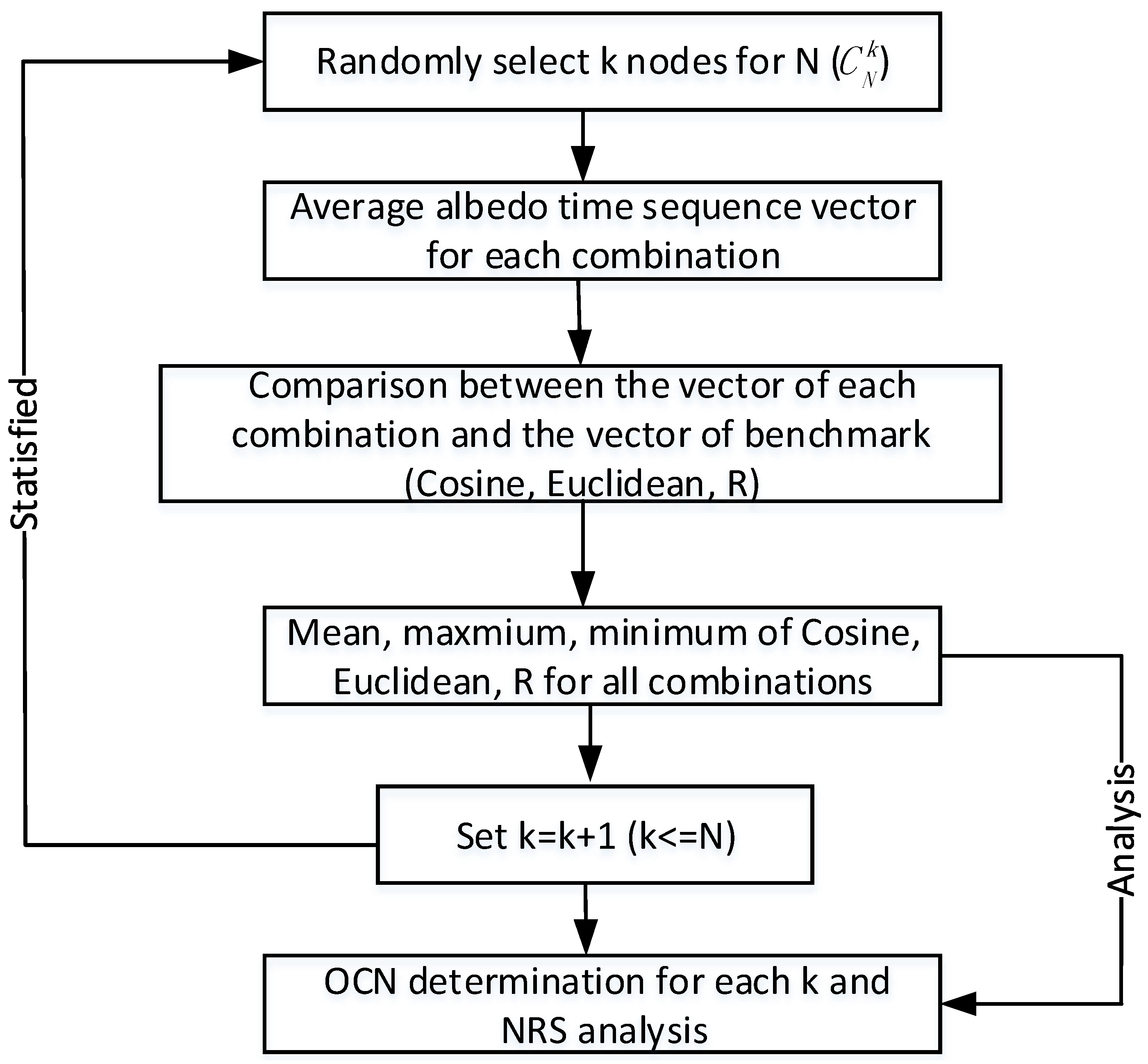
- (1)
- Randomly select k node measurements (k ≤ N) from the available N observations. Thus there are possible combinations in all.
- (2)
- For each possible combination, the time sequence vector of the field mean surface albedo is calculated, thus obtaining time sequence vectors in total.
- (3)
- time sequence vectors are compared with the one vector based N on all measurement nodes (denoted as benchmark); for that, the Cosine, Euclidean and R are calculated. In addition, the mean, maximum, minimum value of the Cosine, Euclidean and R are calculated.
- (4)
- Set k = k+1, repeat step 1 to step 4 until k = N to explore all the possible number of sampled nodes.
3.3. Upscaling Transfer Function
4. Results and Discussion
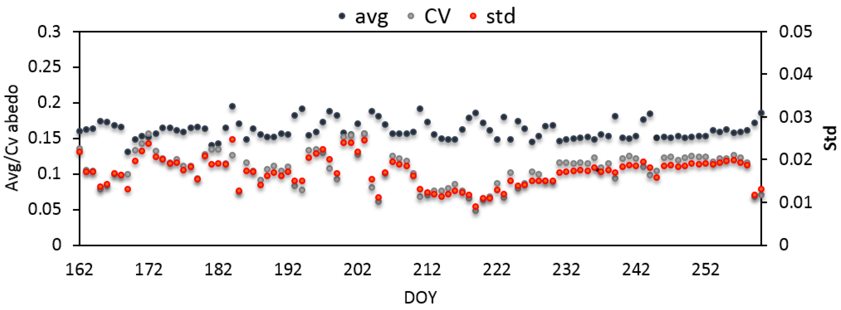
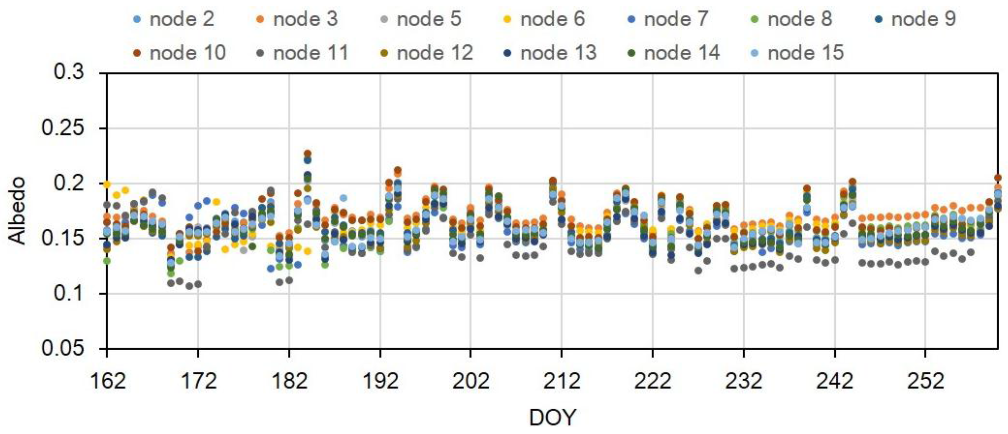
4.1. Spatiotemporal Characteristics
- (a)
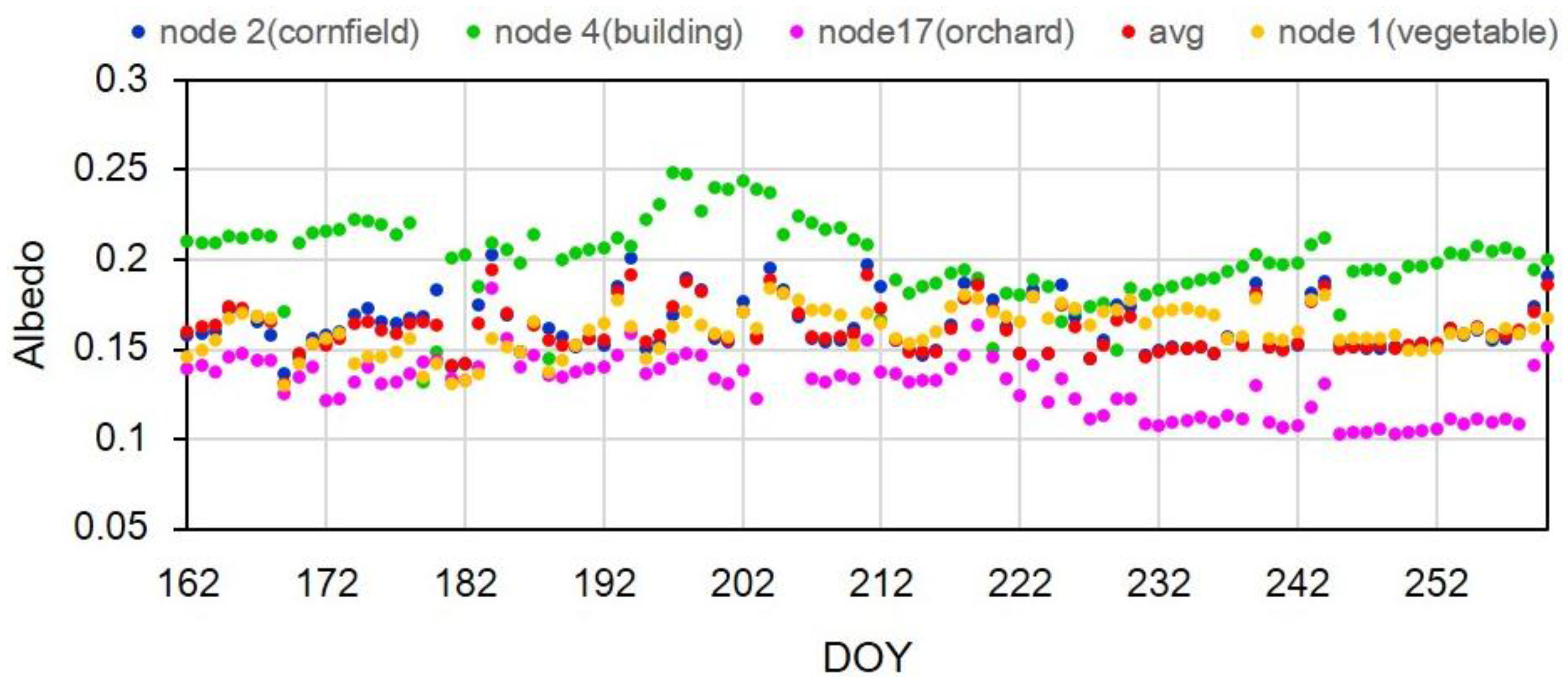
- The daily local-solar-noon field mean surface albedos reveal obvious day-to-day fluctuations. This phenomenon is strongly correlated with the change of the land surface cover. During the experimental period, the cornfields, as the main landcover, start from seed around DOY 162, and then are in closing with a little gap to the background around DOY 207, and at last mature with withered cornstalks around DOY 245. Besides, crop management (irrigation, fertilization, etc.) is frequent during this period, which has a strong impact on the field mean surface albedo.
- (b)
- Avg, std and CV show great temporal fluctuations. In addition, the CV shows almost the same trend as the std, while it shows a large difference compared with avg, indicating that the CV is insensitive to average albedo, and the std is the dominant factor to influence the CV. The highly dependence of CV on std indicates the highly spatial heterogeneity of the study area.

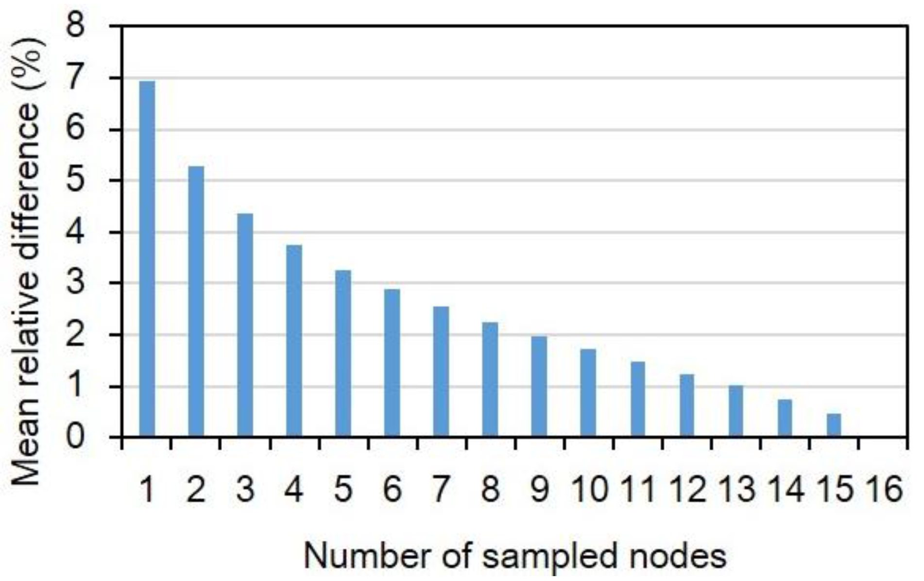
4.2. Spatiotemporal Representativeness of the WSN Nodes

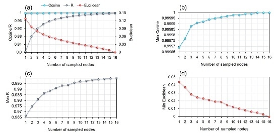
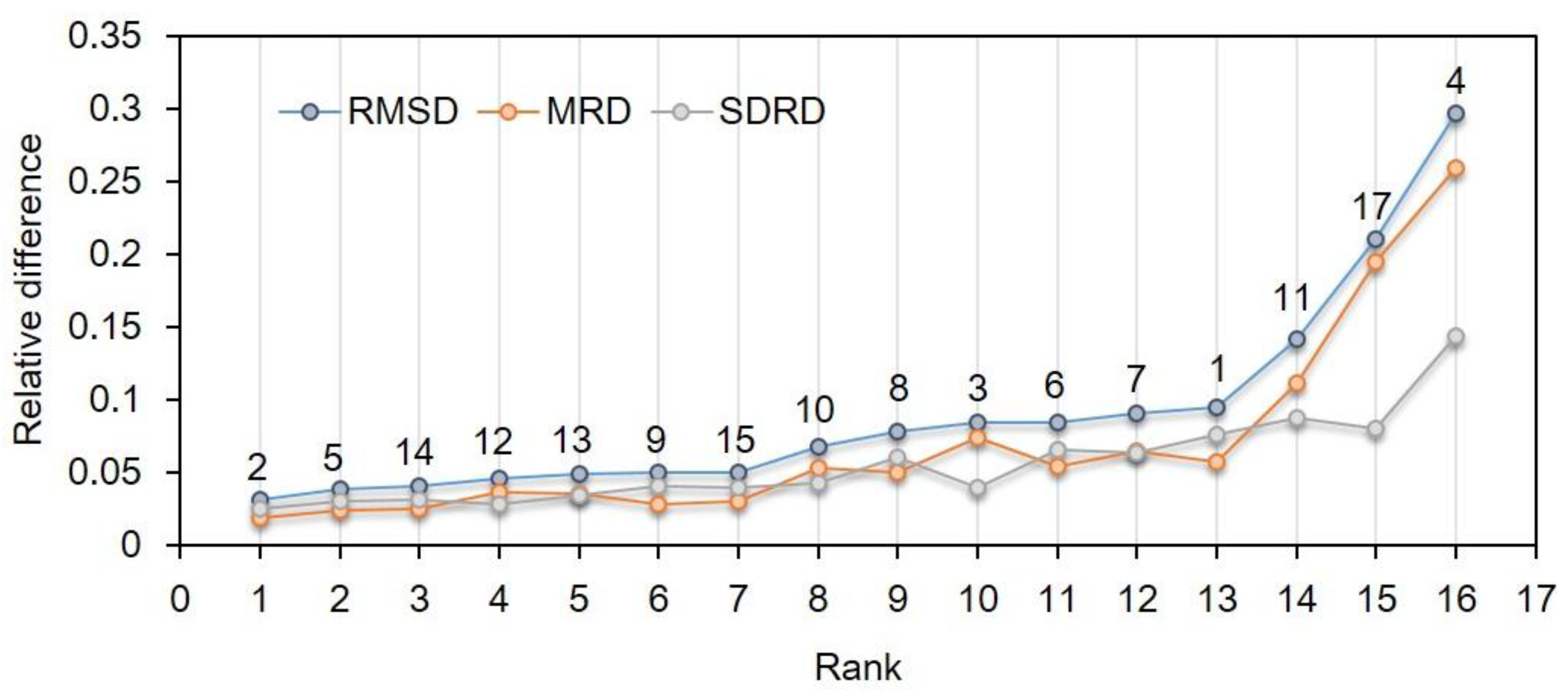
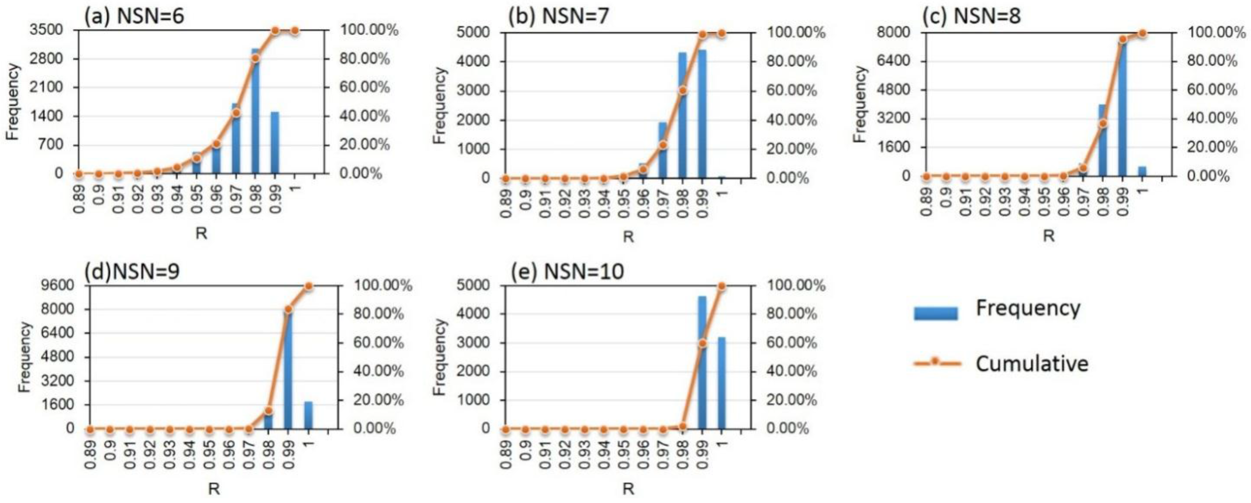
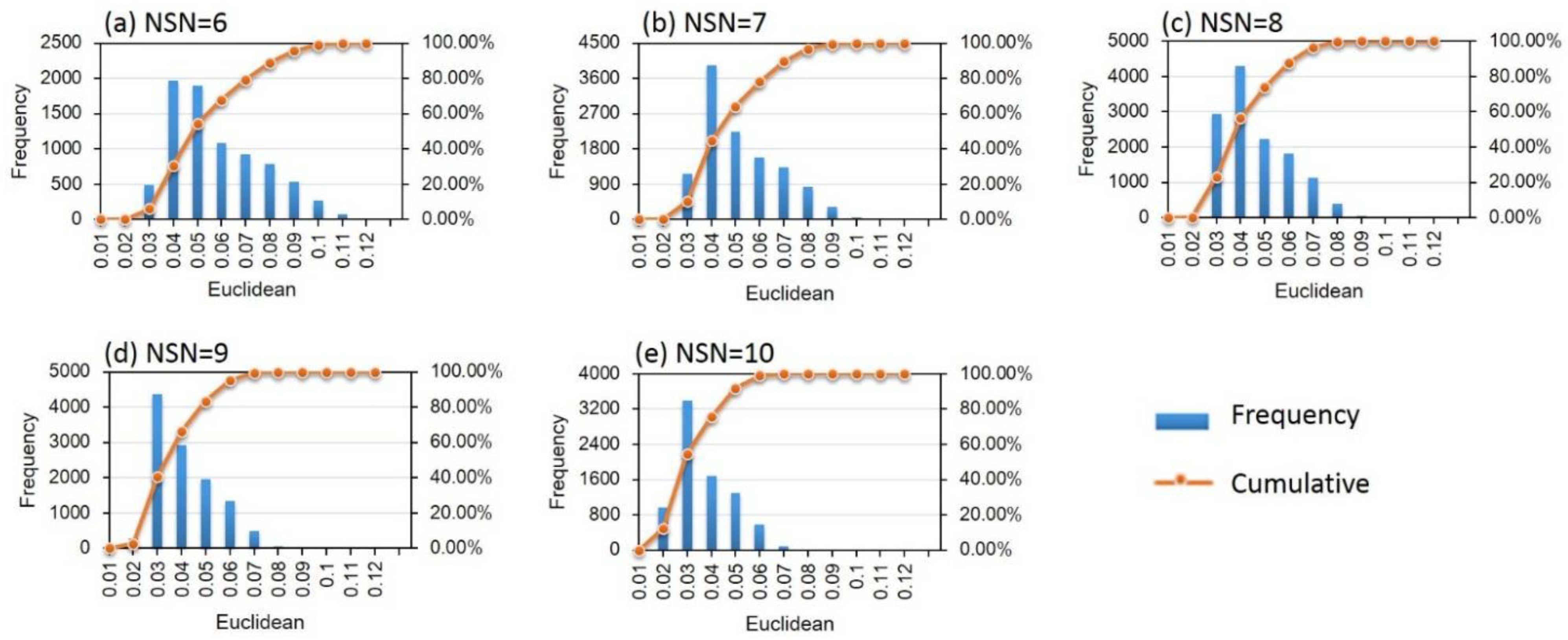
4.3. NRS and MRC Determination

| Number of Sampled Nodes | Cosine | R | Euclidean | ||||||
|---|---|---|---|---|---|---|---|---|---|
| Mean | Max | Min | Mean | Max | Min | Mean | Min | Max | |
| 1 | 0.9981181 | 0.99969 | 0.99315 | 0.8052069 | 0.96633 | 0.24541 | 0.1289426 | 0.043975 | 0.44659 |
| 2 | 0.9990732 | 0.99977 | 0.9957 | 0.8812874 | 0.97472 | 0.44442 | 0.0978517 | 0.037346 | 0.2704 |
| 3 | 0.9994228 | 0.99988 | 0.99786 | 0.9210191 | 0.98106 | 0.64692 | 0.0806185 | 0.028328 | 0.20167 |
| 4 | 0.9995988 | 0.99991 | 0.99862 | 0.944065 | 0.98641 | 0.7603 | 0.0689519 | 0.024508 | 0.1629 |
| 5 | 0.9997047 | 0.99992 | 0.99906 | 0.9586796 | 0.98874 | 0.83394 | 0.0600858 | 0.023139 | 0.13259 |
| 6 | 0.9997758 | 0.99994 | 0.99935 | 0.9686372 | 0.99125 | 0.8903 | 0.052869 | 0.021268 | 0.11133 |
| 7 | 0.9998266 | 0.99995 | 0.99957 | 0.9758096 | 0.99332 | 0.92763 | 0.0467138 | 0.019214 | 0.095883 |
| 8 | 0.999865 | 0.99996 | 0.99965 | 0.981203 | 0.99388 | 0.95092 | 0.0412758 | 0.018718 | 0.083555 |
| 9 | 0.9998948 | 0.99997 | 0.9997 | 0.9853979 | 0.99588 | 0.96487 | 0.0363307 | 0.014846 | 0.074969 |
| 10 | 0.9999188 | 0.99998 | 0.99975 | 0.9887498 | 0.99699 | 0.97121 | 0.0317171 | 0.012533 | 0.067144 |
| 11 | 0.9999386 | 0.99998 | 0.9998 | 0.9914875 | 0.99748 | 0.97516 | 0.0273054 | 0.010248 | 0.060526 |
| 12 | 0.9999548 | 0.99999 | 0.99983 | 0.9937648 | 0.99831 | 0.97937 | 0.0229754 | 0.0081909 | 0.054514 |
| 13 | 0.9999686 | 0.99999 | 0.99988 | 0.9956881 | 0.9989 | 0.98462 | 0.0185927 | 0.0065248 | 0.046738 |
| 14 | 0.9999803 | 1 | 0.99992 | 0.9973334 | 0.99931 | 0.98969 | 0.013961 | 0.0052595 | 0.038804 |
| 15 | 0.9999919 | 1 | 0.99995 | 0.9987569 | 0.9998 | 0.99426 | 0.0086297 | 0.0029524 | 0.029923 |
| 16 | 1 | 1 | 1 | 1 | 1 | 1 | 0 | 0 | 0 |
| Number of Sampled Nodes | Cosine (Max) | R (Max) | Euclidean (Min) |
|---|---|---|---|
| 1 | 2 | 2 | 2 |
| 2 | 2,3 | 5,12 | 7,10 |
| 3 | 3,5,7 | 7,9,14 | 3,5,7 |
| 4 | 2,3,5,7 | 2,3,5,7 | 3,5,7,12 |
| 5 | 2,6,8,13,17 | 2,6,8,13,17 | 1,2,5,7,10 |
| 6 | 3,6,7,13,14,17 | 3,6,7,13,14,17 | 1,3,5,7,9,13 |
| 7 | 2,3,6,7,13,14,17 | 2,3,6,7,13,14,17 | 1,2,3,5,7,9,13 |
| 8 | 2,3,6,7,13,14,15,17 | 2,3,6,7,13,14,15,17 | 1,2,3,5,7,10,11,14 |
| 9 | 1,2,4,5,8,9,10,11,12 | 1,2,4,5,8,9,10,11,12 | 4,6,8,10,11,12,14,15,17 |
| 10 | 1,2,4,5,8,9,10,11,12,15 | 1,2,4,5,8,9,10,11,12,15 | 3,4,6,8,11,12,13,14,15,17 |
| 11 | 1,3,4,5,7,9,10,11,12,14,15 | 1,3,4,5,7,9,10,11,12,14,15 | 2,3,4,6,8,11,12,13,14,15,17 |
| 12 | 1,4,6,8,9,10,11,12,13,14,15,17 | 1,4,6,8,9,10,11,12,13,14,15,17 | 1,2,4,6,8,9,10,11,13,14,15,17 |
| 13 | 1,2,4,6,8,9,10,11,12,13,14,15,17 | 1,2,4,6,8,9,10,11,12,13,14,15,17 | 1,2,4,6,8,9,10,11,12,13,14,15,17 |
| 14 | 1,2,4,5,6,7,8,9,10,11,13,14,15,17 | 1,2,3,4,6,7,8,9,10,11,13,14,15,17 | 1,2,3,4,5,6,8,9,11,12,13,14,15,17 |
| 15 | 1,3,4,5,6,7,8,9,10,11,12,13,14,15,17 | 1,3,4,5,6,7,8,9,10,11,12,13,14,15,17 | 1,3,4,5,6,7,8,9,10,11,12,13,14,15,17 |

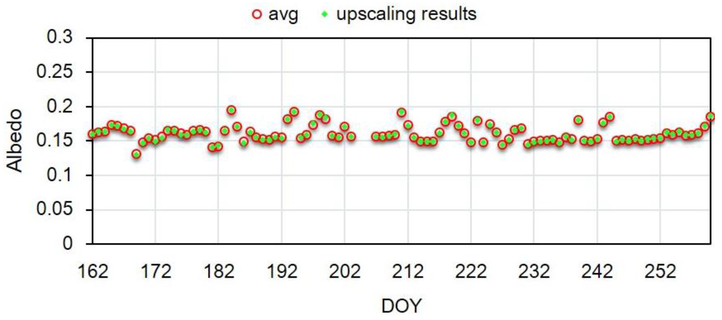
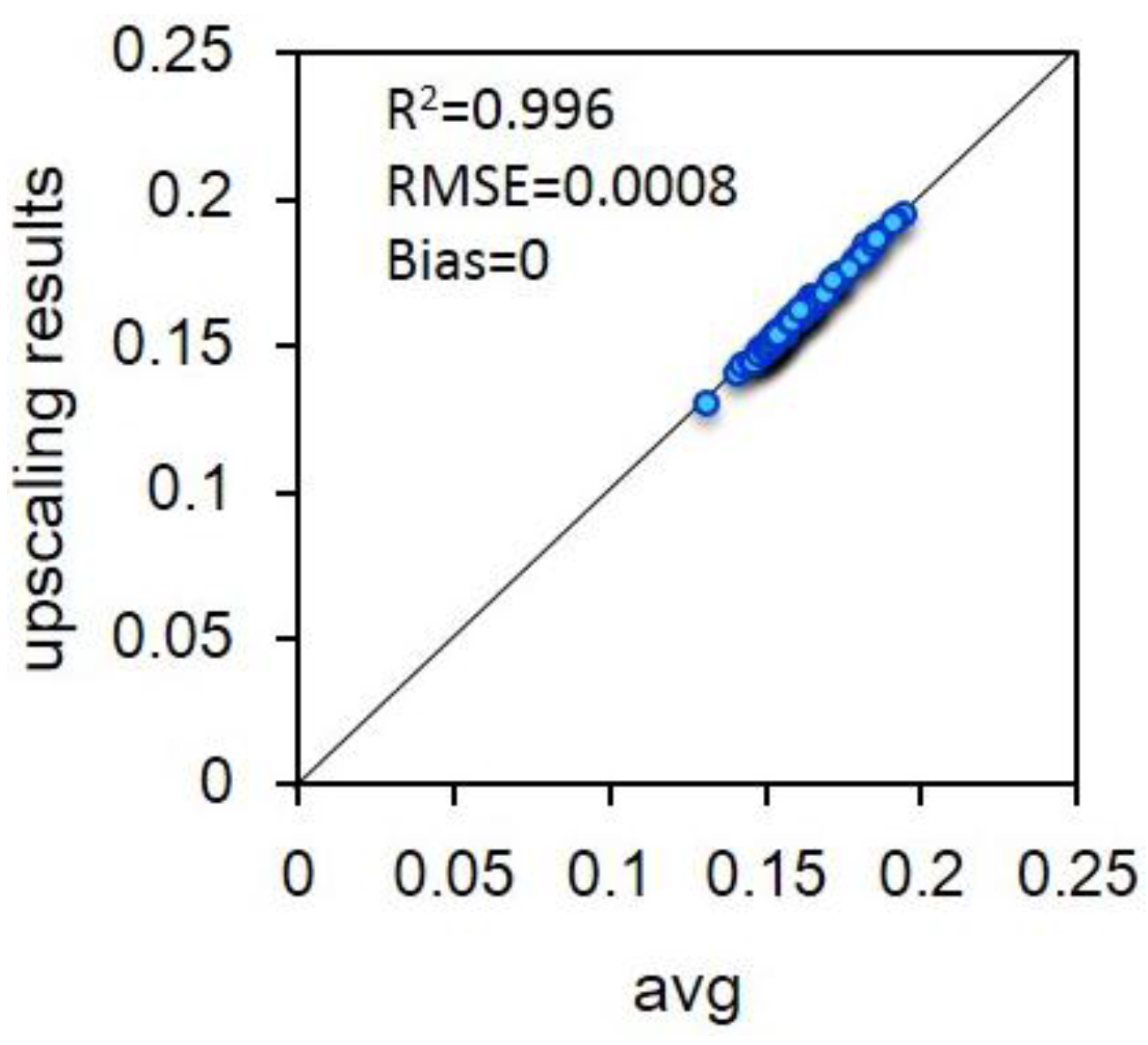
4.4. Upscaling Results and Evaluation
| Node | Weight | Rank |
|---|---|---|
| node4 | 0.090953 | 16 |
| node6 | 0.10031 | 11 |
| node8 | 0.14274 | 9 |
| node10 | 0.14665 | 8 |
| node11 | 0.07954 | 14 |
| node12 | 0.19748 | 4 |
| node14 | 0.073957 | 3 |
| node15 | 0.086302 | 7 |
| node17 | 0.079639 | 15 |
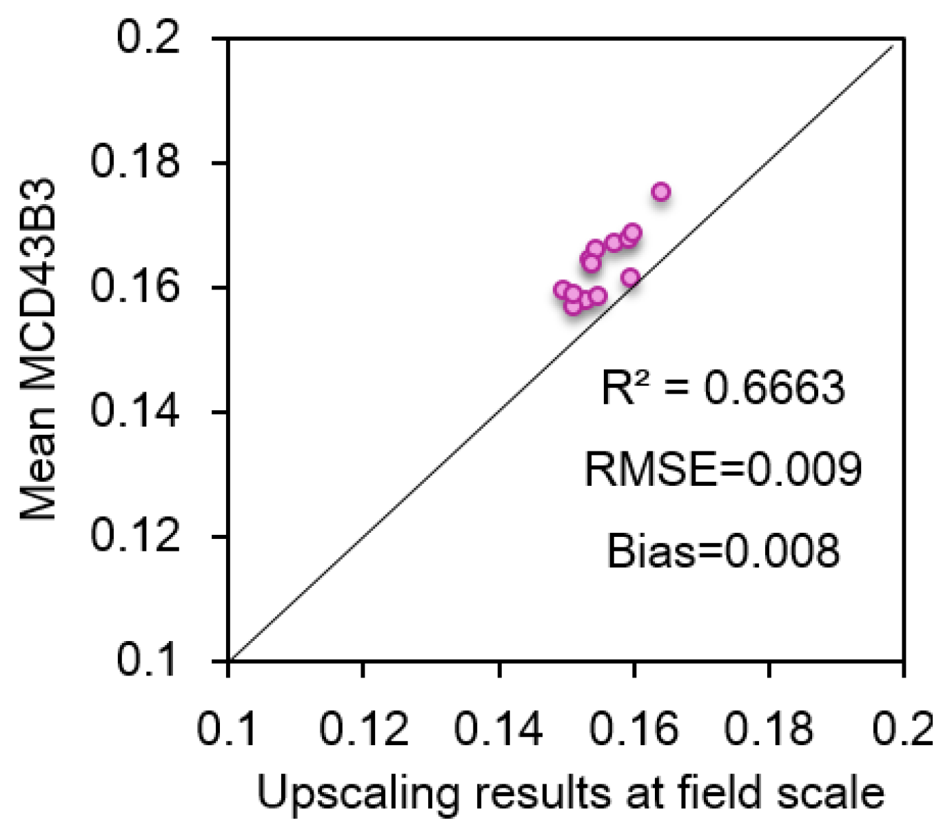
4.5. Preliminary Application for Assessment of MCD43B3 Product
5. Conclusions
Acknowledgments
Author Contributions
Conflicts of Interest
References
- Zhang, X.; Liang, S.; Wang, K.; Li, L.; Gui, S. Analysis of global land surface shortwave broadband albedo from multiple data sources. IEEE J. Sel. Top. Appl. Earth Obs. Remote Sens. 2010, 3, 296–305. [Google Scholar] [CrossRef]
- Sellers, P.J. Remote Sensing of Land Surface Climatology Change. In NASA/GSFC International Satellite Land Surface Climatology Project Report; NASA Goddard Space Flight Cent.: Greenbelt, MD, USA, 1993. [Google Scholar]
- Liang, S. Narrowband to broadband conversions of land surface albedo. I: Algorithms. Remote Sens. Environ. 2001, 76, 213–238. [Google Scholar] [CrossRef]
- Wen, J.G.; Zhao, X.J.; Liu, Q.; Tang, Y.; Dou, B.C. An improved land-surface albedo algorithm with DEM in rugged terrain. IEEE Geosci. Remote Sens. Lett. 2014, 11, 883–887. [Google Scholar] [CrossRef]
- Peng, J.J.; Liu, Q.; Wen, J.G.; Liu, Q.H.; Tang, Y.; Wang, L.Z.; Dou, B.C.; You, D.Q.; Sun, C.K.; Zhao, X.J.; et al. Multi-scale validation strategy for satellite albedo products and its uncertainty analysis. Sci. China: Earth Sci. 2015, 58, 573–588. [Google Scholar] [CrossRef]
- Liang, X.; Xu, M.; Gao, W.; Kunkel, K.; Slusser, J.; Dai, Y.; Min, Q.; Houser, P.R.; Rodell, M.; Schaaf, C.B.; et al. Development of land surface albedo parameterization based on Moderate Resolution Imaging Spectroradiometer (MODIS) data. J. Geophys. Res. Atmos. 2005, 110, 1341–1355. [Google Scholar] [CrossRef]
- Jin, Y.; Schaaf, C.B.; Woodcock, C.E.; Gao, F.; Li, X.; Strahler, A.H.; Lucht, W.; Liang, S. Consistency of MODIS surface bidirectional reflectance distribution function and albedo retrievals: 2. Validation. J. Geophys. Res. 2003, 108, 4159–4159. [Google Scholar] [CrossRef]
- Román, M.O.; Schaaf, C.B.; Woodcock, C.E.; Strahler, A.H.; Yang, X.; Braswell, R.H.; Wofsy, S.C. The MODIS (Collection V005) BRDF/albedo product: Assessment of spatial representativeness over forested landscapes. Remote Sens. Environ. 2009, 113, 2476–2498. [Google Scholar] [CrossRef]
- Román, M.O.; Gatebe, C.K.; Shuai, Y.M.; Wang, Z.S.; Gao, F.; Masek, J.G.; He, T.; Liang, S.L.; Schaaf, C.B. Use of in situ and airborne multiangle data to assess MODIS- and Landsat-Based estimates of directional reflectance and albedo. IEEE Trans. Geosci. Remote Sens. 2013, 51, 1393–1404. [Google Scholar] [CrossRef]
- Wang, Z.S.; Schaaf, C.B.; Chopping, M.J.; Strahler, A.H.; Wang, J.D.; Román, M.O.; Rocha, A.V.; Woodcock, C.E.; Shuai, Y.M. Evaluation of moderate-resolution imaging spectroradiometer (MODIS) snow albedo product (MCD43A) over tundra. Remote Sens. Environ. 2012, 117, 264–280. [Google Scholar] [CrossRef]
- Wang, Z.S.; Schaaf, C.B.; Chopping, M.J.; Román, M.O.; Shuai, Y.; Fitzjarrald, D.R. Evaluation of MODIS albedo product (MCD43A) over grassland, agriculture and forest surface types during dormant and snow-covered periods. Remote Sens. Environ. 2014, 140, 60–77. [Google Scholar] [CrossRef]
- Cescatti, A.; Marcolla, B.; Santhana Vannan, S.K.; Pan, J.Y.; Román, M.O.; Yang, X.; Schaaf, C.B. Intercomparison of MODIS albedo retrievals and in situ measurements across the global FLUXNET network. Remote Sens. Environ. 2012, 121, 323–334. [Google Scholar] [CrossRef]
- Liang, S.; Fang, H.; Chen, M.; Shuey, C.J.; Walthall, C.; Daughtry, C.; Morisette, J.; Schaaf, C.; Strahler, A. Validating MODIS land surface reflectance and albedo products: Methods and preliminary results. Remote Sens. Environ. 2002, 83, 149–162. [Google Scholar] [CrossRef]
- Wu, X.D.; Xiao, Q.; Wen, J.G.; Liu, Q.; You, D.Q.; Dou, B.C.; Lei, F.; Tang, Y.; Li, X.W. Upscaling albedo over heterogeneous surfaces using ground measurements and high-resolution imagery. Remote Sens. 2015, submitted. [Google Scholar]
- Wu, X.D.; Wen, J.G.; Xiao, Q.; Liu, Q.; Peng, J.J.; Dou, B.C.; Li, X.H.; You, D.Q.; Tang, Y.; Liu, Q.H.; et al. Coarse scale wireless sensor network-based albedo observations over heterogeneous land surfaces and preliminary results of validating Modis remote sensing products over Northern China. Remote Sens. Environ. 2015. submitted. [Google Scholar]
- Kang, J.; Jin, R.; Li, X. Regression kriging-based upscaling of soil moisture measurements from a wireless sensor network and multiresource remote sensing information over heterogeneous cropland. IEEE Geosci. Remote Sens. Lett. 2015, 12, 92–96. [Google Scholar] [CrossRef]
- Xu, Z.; Liu, S.; Li, X.; Shi, S.; Wang, J.; Zhu, Z.; Ma, M. Intercomparison of surface energy flux measurement systems used during the HiWATER-MUSOEXE. J. Geophys. Res.: Atmos. 2013, 118, 130–140. [Google Scholar] [CrossRef]
- Vachaud, G.; Passerat de Silans, A.; Balabanis, P.; Vauclin, M. Temporal stability of spatially measured soil water probability density function. Soil Sci. Soc. Am. J. 1985, 49, 822–828. [Google Scholar] [CrossRef]
- Hills, R.C.; Reynolds, S.G. Illustrations of soil moisture variability in selected areas and plots of different sizes. J. Hydrol. 1969, 8, 27–47. [Google Scholar] [CrossRef]
- Dane, J.H.; Reed, R.B.; Hopmans, J.W. Estimating soil parameters and sample-size by bootstrapping. Soil Soc. Am. J. 1986, 50, 283–287. [Google Scholar] [CrossRef]
- Famiglietti, J.S.; Devereaux, A.; Laymon, C.A.; Tsegaye, T.; Houser, P.R.; Jackson, T.J.; Graham, S.T.; Rodell, M.; Oevelen, P.J. Ground-based investigation of soil moisture variability within remote sensing footprints during the Southern Great Plains 1997 (SGP97) hydrology experiment. Water Resour. Res. 1999, 35, 1839–1851. [Google Scholar] [CrossRef]
- Famiglietti, J.S.; Ryu, D.; Berg, A.A.; Rodell, M.; Jackson, T.J. Field observations of soil moisture variability across scales. Water Resour. Res. 2008, 44, W01423. [Google Scholar] [CrossRef]
- Hupet, F.; Vanclooster, M. Intraseasonal dynamics of soil moisture variability within a small agricultural maize cropped field. J. Hydrol. 2002, 261, 86–101. [Google Scholar] [CrossRef]
- Brocca, L.; Morbidelli, R.; Melone, F.; Moramarco, T. Soil moisture spatial variability in experimental areas of central Italy. J. Hydrol. 2007, 333, 356–373. [Google Scholar] [CrossRef]
- Zhao, L.; Yang, K.; Qin, J.; Chen, Y.Y.; Tang, W.J.; Montzka, C.; Wu, H.; Lin, C.G.; Han, M.L.; Vereecken, H. Spatiotemporal analysis of soil moisture observations within a Tibetan mesoscale area and its implication to regional soil moisture measurements. J. Hydrol. 2013, 482, 92–104. [Google Scholar] [CrossRef]
- Cosh, M.H.; Jackson, T.J.; Bindlish, R.; Prueger, J.H. Watershed scale temporal and spatial stability of soil moisture and its role in validating satellite estimates. Remote Sens. Environ. 2004, 92, 427–435. [Google Scholar] [CrossRef]
- Martínez-Fernández, J.; Ceballos, A. Mean soil moisture estimation using temporal stability analysis. J. Hydrol. 2005, 312, 28–38. [Google Scholar] [CrossRef]
- Brocca, L.; Melone, F.; Moramarco, T.; Morbidelli, R. Spatial-temporal variability of soil moisture and its estimation across scales. Water Resour. Res. 2010, 46, W02516. [Google Scholar] [CrossRef]
- Brocca, L.; Tullo, T.; Melone, F.; Moramarco, T.; Morbidelli, R. Catchment scale soil moisture spatial-temporal variability. J. Hydrol. 2012, 422–423, 63–75. [Google Scholar] [CrossRef]
- Vanderlinden, K.; Vereecken, H.; Hardelauf, H.; Herbst, M.; Martínez, G.; Cosh, M.H.; Pachepsky, Y.A. Temporal stability of soil water contents: A review of data and analyses. Vadose Zone J. 2012, 11, 280–288. [Google Scholar] [CrossRef]
- Mcbratney, A.B.; Webster, R. How many observations are needed for regional estimation of soil properties? Soil Sci. 1983, 135, 177–183. [Google Scholar] [CrossRef]
- Di, H.J.; Trangmar, B.B.; Kemp, R.A. Use of geostatistics in designing sampling strategies for soil survey. Soil Sci. Soc. Am. J. 1989, 53, 1163–1167. [Google Scholar] [CrossRef]
- Chung, C.K.; Chong, S.; Varsa, E.C. Sampling strategies for fertility on a stony silt loam soil. Commun. Soil Sci. Plant Anal. 1995, 26, 741–763. [Google Scholar] [CrossRef]
- Cochran, W.G. Sampling Techniques, 3ed.; John Wiley & Sons, Inc.: New York, NY, USA, 1977; pp. 89–110. [Google Scholar]
- Miyamoto, S.; Chacon, A.; Hossain, M.; Martinez, I. Soil salinity of urban turf areas irrigated with saline water: I. Spatial variability. Landsc. Urban Plan. 2005, 71, 233–241. [Google Scholar] [CrossRef]
- Efron, B. Computers and the theory of statistics: solid thinking the unthinkable. Soc. Ind. Appl. Math. 1979, 21, 460–480. [Google Scholar] [CrossRef]
- Efron, B. The Jackknife, the Bootstrap and Other Resampling Plans. Soc. Ind. Appl. Math. 1982, 38. [Google Scholar] [CrossRef]
- Efron, B.; Gong, G. A leisurely look at the bootstrap, the jackknife, and cross-validation. Am. Stat. 1983, 37, 36–48. [Google Scholar]
- Diaconis, P.; Efron, B. Computer intensive methods in statistics. Soc. Ind. Appl. Math. 1983, 248, 116–130. [Google Scholar] [CrossRef]
- Brocca, L.; Melone, F.; Moramarco, T.; Morbidelli, R. Soil moisture temporal stability over experimental areas in central Italy. Geoderma 2009, 148, 364–374. [Google Scholar] [CrossRef]
- Wang, C.M.; Zuo, Q.; Zhang, R.D. Estimating the necessary sampling size of surface soil moisture at different scales using a random combination method. J. Hydrol. 2008, 352, 309–321. [Google Scholar] [CrossRef]
- Manly, B.F.J. Randomization, Bootstrap and Monte Carlo Methods in Biology, 2nd ed.; Chapman & Hall Press: London, UK, 1997; pp. 34–35. [Google Scholar]
- Cheng, G.D. Integrated Management of the Water-Ecology-E-Conomy System in the Heihe River Basin; Science Press: Beijing, China, 2009; p. 581. [Google Scholar]
- Li, X.; Cheng, G.; Liu, S.; Xiao, Q.; Ma, M.; Jin, R.; Xu, Z. Heihe watershed allied telemetry experimental research (HiWATER): Scientific objectives and experimental design. Bull. Am. Meteorol. Soc. 2013, 94, 1145–1160. [Google Scholar] [CrossRef]
- Sailor, D.J.; Resh, K.; Segura, D. Field measurement of albedo for limited extent test surfaces. Sol. Energy. 2006, 80, 589–599. [Google Scholar] [CrossRef]
- NASA’s Earth Observing System/ Data and Information System. Available online: http://reverb.echo.nasa.gov/reverb/ (accessed on 26 October 2015).
- Lucht, W.; Schaaf, C.B.; Strahler, A.H. An algorithm for the retrieval of albedo from space using semiempirical BRDF models. IEEE Trans. Geosci. Remote Sens. 2000, 38, 977–998. [Google Scholar] [CrossRef]
- Wanner, W.; Strahler, A.H.; Hu, B.; Lewis, P.; Muller, J.P.; Li, X.; Barker Schaaf, C.L.; Barnsley, M.J. Global retrieval of bidirectional reflectance and albedo over land from EOS MODIS and MISR data: Theory and algorithm. J. Geophys. Res.: Atmos. 1997, 102, 17143–17161. [Google Scholar] [CrossRef]
- Grayson, R.B.; Western, A.W. Towards areal estimation of soil water content from point measurements: Time and space stability of mean response. J. Hydrol. 1998, 207, 68–82. [Google Scholar] [CrossRef]
- Jacobs, J.M.; Mohanty, B.P.; Hsu, E.-C.; Miller, D. SMEX02: Field scale variability, time stability and similarity of soil moisture. Remote Sens. Environ. 2004, 92, 436–446. [Google Scholar] [CrossRef]
- Bell, K.R.; Blanchard, B.J.; Schmugge, T.J.; Witczak, M.W. Analysis of surface moisture variations within large field sites. Water Resour. Res. 1980, 16, 796–810. [Google Scholar] [CrossRef]
- Owe, M.; Jones, E.B.; Schmugge, T.J. Soil moisture variation patterns observed in hand county, South Dakota. JAWRA J. Am. Water Res. Assoc. 1982, 18, 949–954. [Google Scholar] [CrossRef]
- Gilbert, R.O. Statistical Methods for Environmental Pollution Monitoring; Van Nostrand Reinhold Company, Inc.: New York, NY, USA, 1987; pp. 26–54. [Google Scholar]
- Zhang, Y.; Liu, Y.D.; Zhao, J.I. Vector similarity measurement method. Tech. Acoust. 2009, 28, 532–536. [Google Scholar]
- Neter, J.; Kutner, M.H.; Nachtsheim, C.J.; Wasserman, W. Applied Linear Statistical Models, 4th ed.; McGraw-Hill: Boston, MA, USA, 1996; p. 1391. [Google Scholar]
© 2015 by the authors; licensee MDPI, Basel, Switzerland. This article is an open access article distributed under the terms and conditions of the Creative Commons Attribution license (http://creativecommons.org/licenses/by/4.0/).
Share and Cite
Wu, X.; Xiao, Q.; Wen, J.; Liu, Q.; You, D.; Dou, B.; Tang, Y.; Li, X. Optimal Nodes Selectiveness from WSN to Fit Field Scale Albedo Observation and Validation in Long Time Series in the Foci Experiment Areas, Heihe. Remote Sens. 2015, 7, 14757-14780. https://doi.org/10.3390/rs71114757
Wu X, Xiao Q, Wen J, Liu Q, You D, Dou B, Tang Y, Li X. Optimal Nodes Selectiveness from WSN to Fit Field Scale Albedo Observation and Validation in Long Time Series in the Foci Experiment Areas, Heihe. Remote Sensing. 2015; 7(11):14757-14780. https://doi.org/10.3390/rs71114757
Chicago/Turabian StyleWu, Xiaodan, Qing Xiao, Jianguang Wen, Qiang Liu, Dongqin You, Baocheng Dou, Yong Tang, and Xiaowen Li. 2015. "Optimal Nodes Selectiveness from WSN to Fit Field Scale Albedo Observation and Validation in Long Time Series in the Foci Experiment Areas, Heihe" Remote Sensing 7, no. 11: 14757-14780. https://doi.org/10.3390/rs71114757
APA StyleWu, X., Xiao, Q., Wen, J., Liu, Q., You, D., Dou, B., Tang, Y., & Li, X. (2015). Optimal Nodes Selectiveness from WSN to Fit Field Scale Albedo Observation and Validation in Long Time Series in the Foci Experiment Areas, Heihe. Remote Sensing, 7(11), 14757-14780. https://doi.org/10.3390/rs71114757