Potential of X-Band TerraSAR-X and COSMO-SkyMed SAR Data for the Assessment of Physical Soil Parameters
Abstract
:1. Introduction
2. Study Site and Database Description
2.1. Study Site Description
2.2. Database Description
2.2.1. Satellite Images
| Nr | Sensor | Date of Acquisition (dd/mm/yyyy) | Acquisition Time (UTC) | Acquisition Mode | Pol Mode | Inci. | Orbit | Geometric Resolution (m) |
|---|---|---|---|---|---|---|---|---|
| 1 | CSK1 | 06/11/2013 | 17:21:24 | PingPong | HV/HH | 26° | Desc | 7.9 |
| 2 | TSX | 09/11/2013 | 17:13:34 | Spotlight | HH/VV | 36° | Asc | 1.8 |
| 3 | TSX | 20/11/2013 | 17:13:34 | Spotlight | HH/VV | 36° | Asc | 1.8 |
| 4 | CSK1 | 22/11/2013 | 17:21:19 | PingPong | HV/HH | 26° | Desc | 7.9 |
| 5 | TSX | 01/12/2013 | 17:14:17 | Spotlight | HH/VV | 36° | Asc | 1.8 |
| 6 | CSK4 | 04/12/2013 | 17:21:14 | PingPong | HV/HH | 26° | Desc | 7.9 |
| 7 | CSK2 | 05/12/2013 | 17:15:13 | PingPong | HV/HH | 36° | Desc | 7.9 |
| 8 | TSX | 12/12/2013 | 17:14:17 | Spotlight | HH/VV | 36° | Asc | 1.8 |
| 9 | TSX | 23/12/2013 | 17:14:16 | Spotlight | HH/VV | 36° | Asc | 1.8 |
| 10 | TSX | 14/01/2014 | 17:14:15 | Spotlight | HH/VV | 36° | Asc | 1.8 |
| 11 | TSX | 25/01/2014 | 17:14:15 | Spotlight | HH/VV | 36° | Asc | 1.8 |
2.2.2. Ground Measurements
Soil Moisture
Soil Roughness
Soil Texture
3. Statistical Analysis of Radar Measurements
3.1. Inter-Comparison between TerraSAR-X and COSMO-SkyMed Measurements
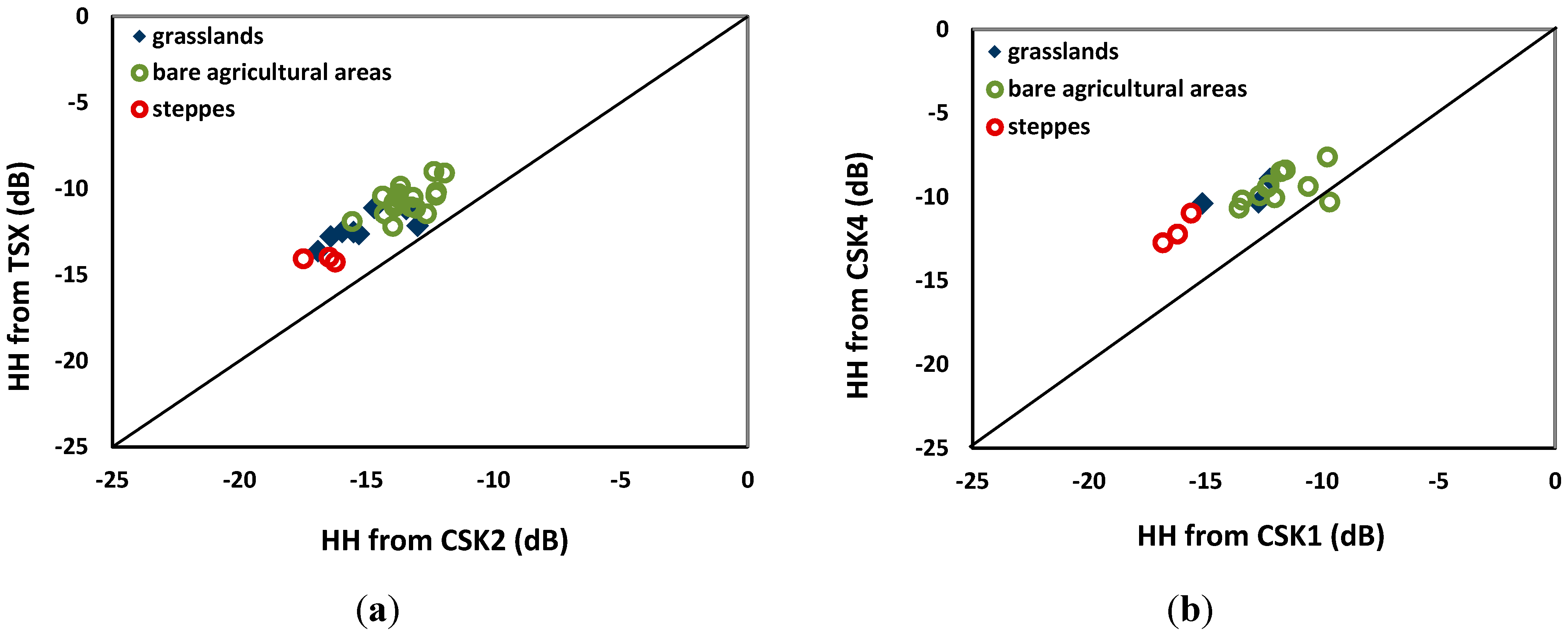
3.2. Relationship between Radar Signal and Soil Roughness
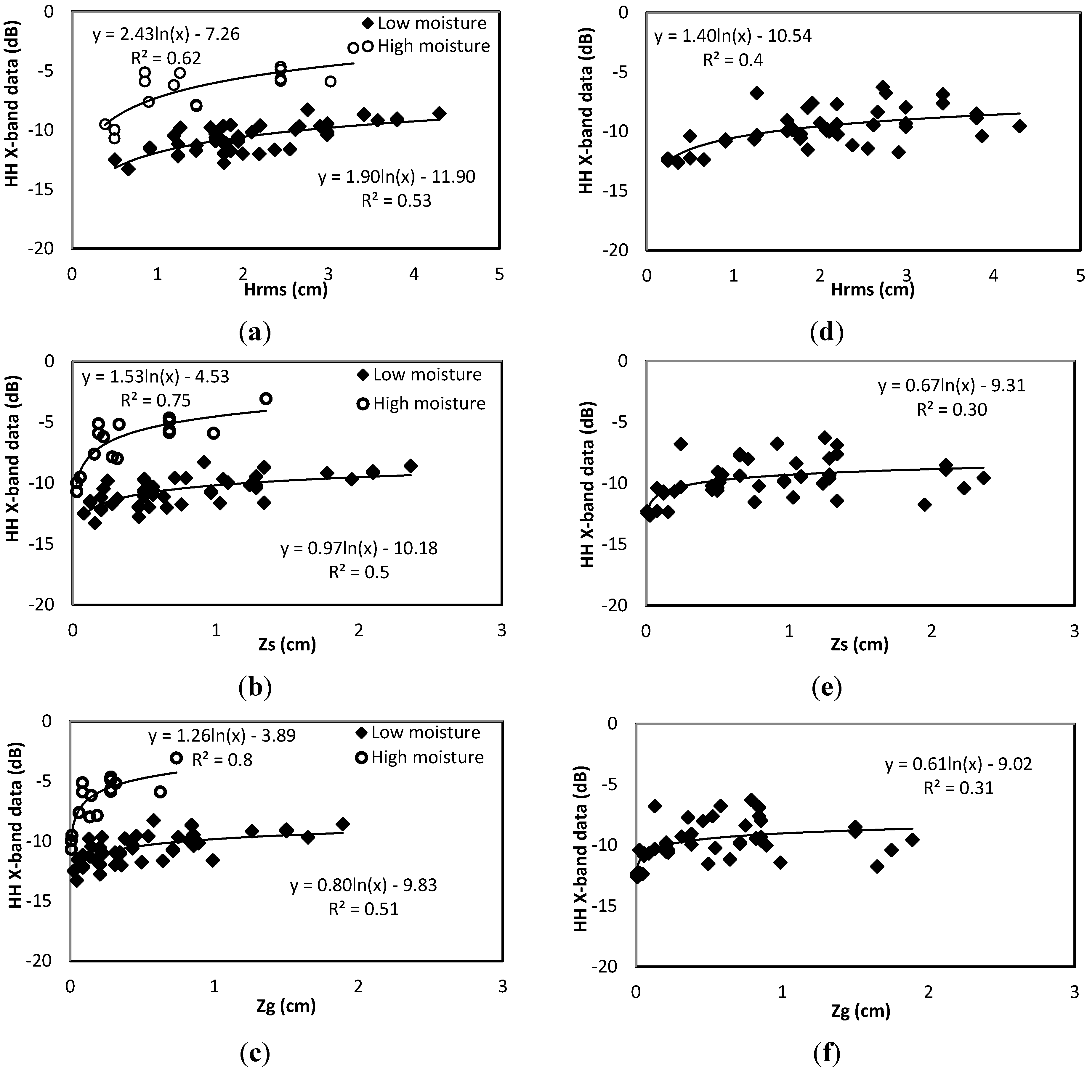
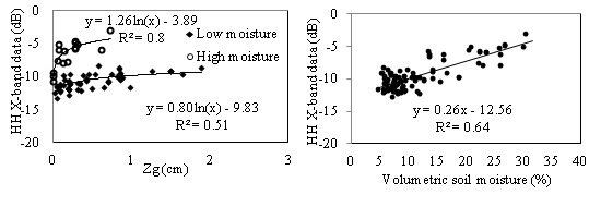
| HH Polarization | VV Polarization | ||||
|---|---|---|---|---|---|
| Low Moisture | High Moisture | Low Moisture | High Moisture | ||
| 36° | Hrms | 0.53 | 0.62 | 0.57 | 0.6 |
| Zs | 0.5 | 0.75 | 0.52 | 0.77 | |
| Zg | 0.51 | 0.8 | 0.53 | 0.8 | |
| 26° | Hrms | 0.4 | |||
| Zs | 0.3 | ||||
| Zg | 0.31 | ||||
3.3. Relationship between Radar Signal and Soil Moisture Content
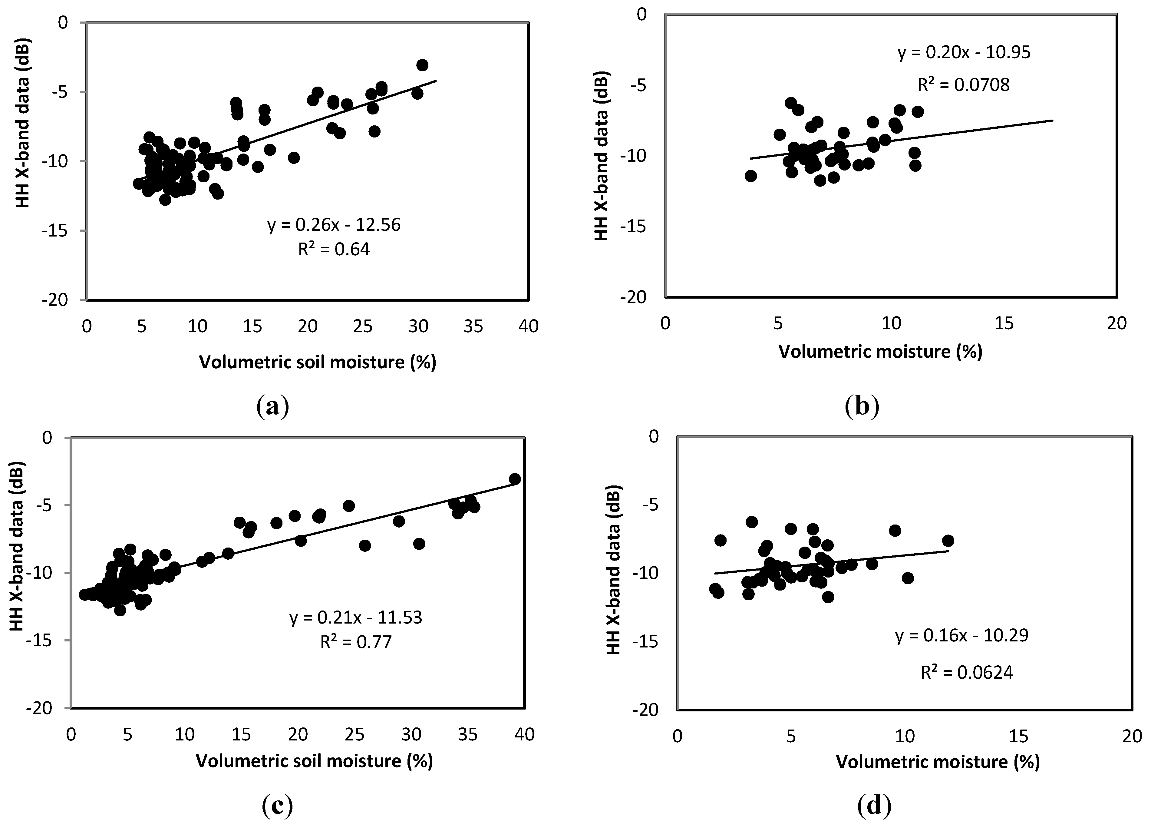
3.4. Relationship between Radar Signal and Soil Parameters
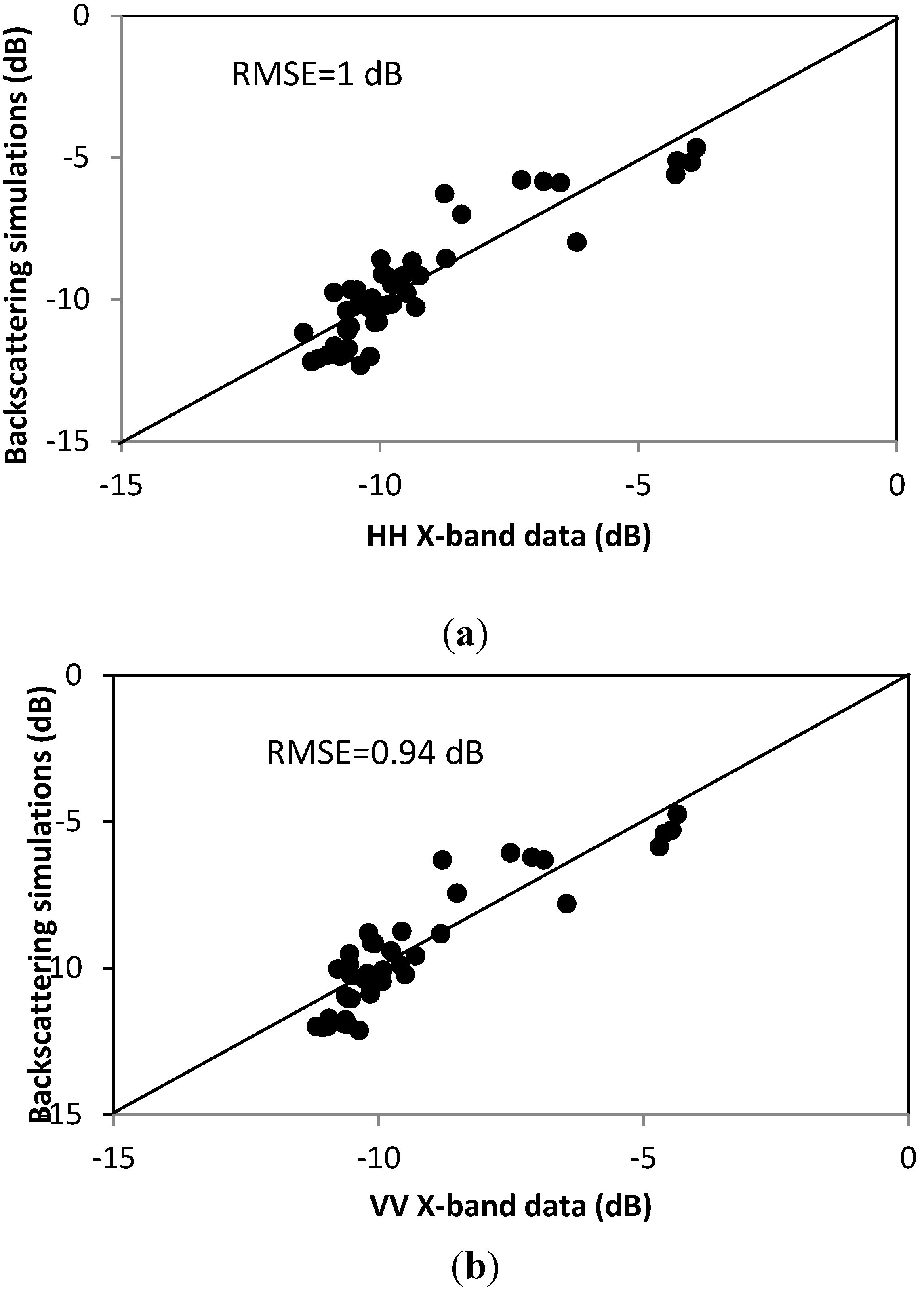
4. Evaluation of Backscattering Models
4.1. IEM Model
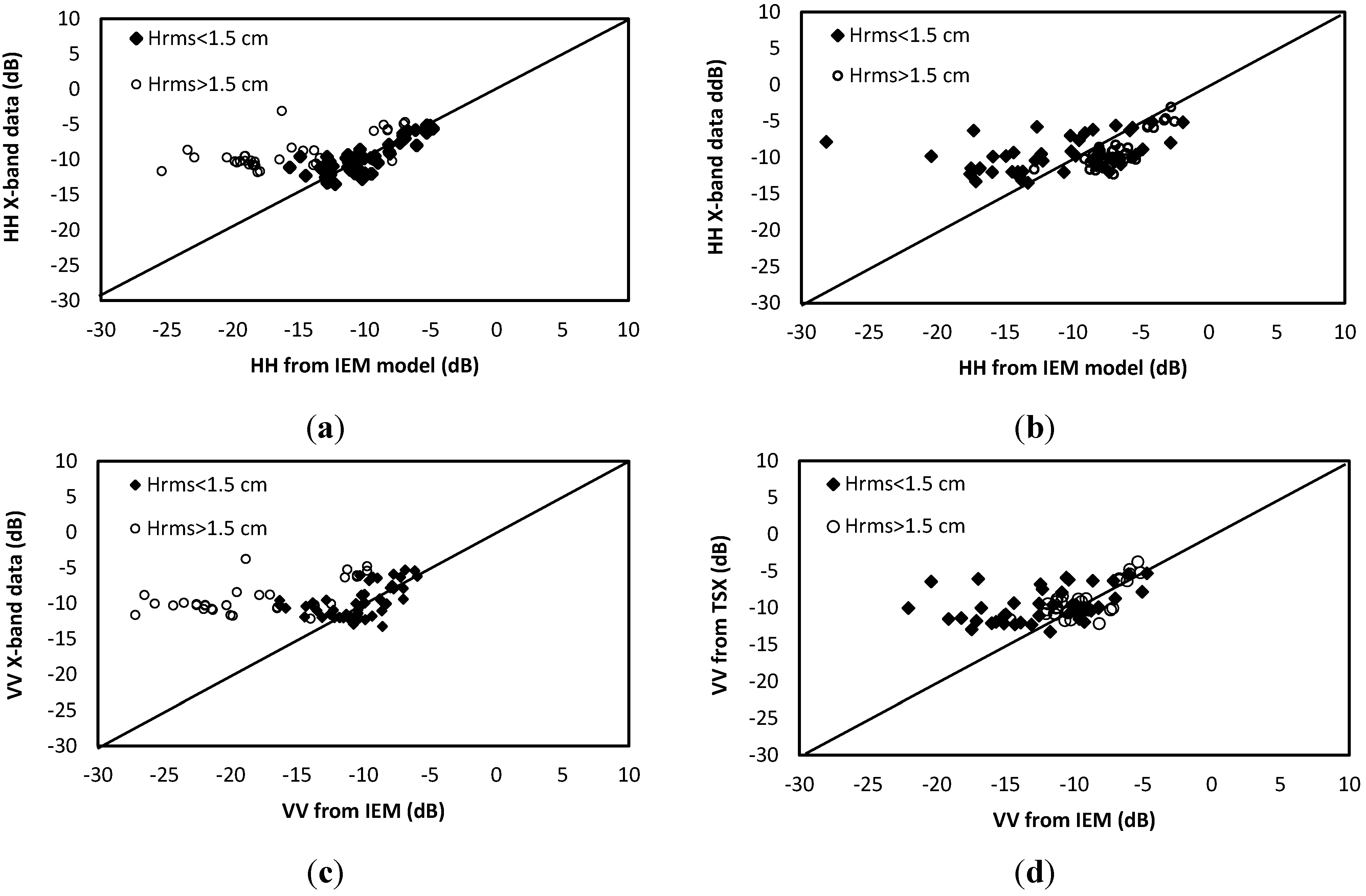
- -
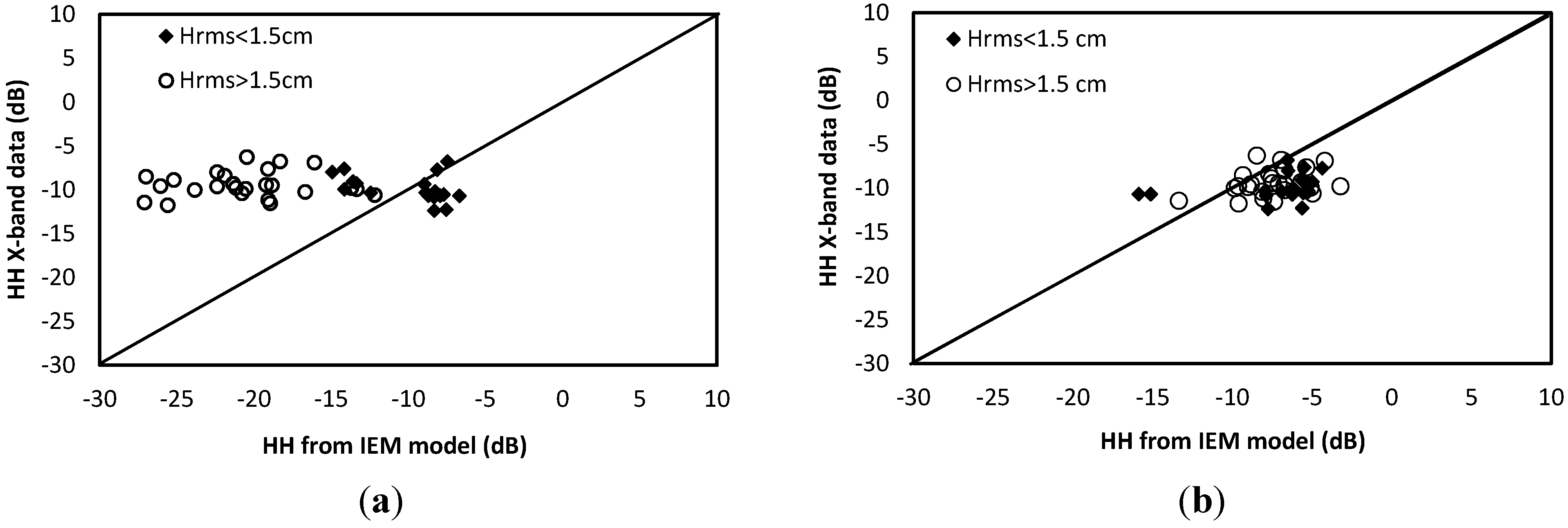
- In the HH polarization, for Hrms < 1.5 cm, with an exponential correlation function: at θ = 36°, bias = 0.29 dB and RMSE = 1.59 dB; and at θ = 26°, bias = 0.08 dB and RMSE = 3.54 dB. On the other hand, the IEM model tends to over-estimate the backscattering coefficient σ0HH in the following cases: Hrms > 1.5 cm with a Gaussian correlation function: bias approximately −2.31 and −1.98 dB, and RMSE equal to 2.64 and 2.9 dB, for θ = 36° and θ = 26°, respectively.
- -
- In the VV polarization, for Hrms < 1.5 cm, with an exponential correlation function: at θ = 36°, bias = 0.63 dB and RMSE = 2.4 dB. For Hrms > 1.5 cm, with a Gaussian correlation function: at 36°, bias = 0.24 and RMSE = 1.66 dB.
4.2. Dubois Model
4.3. Baghdadi Calibrated IEM Version

| HH Polarization | VV Polarization | ||||
|---|---|---|---|---|---|
| IEM Model (Using Measured Correlation Length) | |||||
| Bias (dB) | RMSE (dB) | Bias (dB) | RMSE (dB) | ||
| 36° (Exponential function) | Hrms < 1.5 cm | 0.29 | 1.59 | 0.63 | 2.41 |
| Hrms > 1.5 cm | 4.56 | 7.78 | 6.04 | 9.21 | |
| All Hrms | 2.11 | 5.2 | 3.34 | 6.72 | |
| 36° (Gaussian function) | Hrms < 1.5 cm | 3.42 | 8.2 | 4.32 | 8.36 |
| Hrms > 1.5 cm | −2.31 | 2.64 | 0.24 | 1.66 | |
| All Hrms | 0.99 | 6.5 | 3 | 6.9 | |
| 26° (Exponential function) | Hrms < 1.5 cm | 0.08 | 3.54 | ||
| Hrms > 1.5 cm | 11.1 | 11.8 | |||
| All Hrms | 6.45 | 3.05 | |||
| 26° (Gaussian function) | Hrms < 1.5 cm | −1.28 | 3.6 | ||
| Hrms > 1.5 cm | −1.98 | 2.89 | |||
| All Hrms | −1.2 | 3 | |||
| HH Polarization | VV Polarization | ||||
| Dubois Model | |||||
| Bias (dB) | RMSE (dB) | Bias (dB) | RMSE (dB) | ||
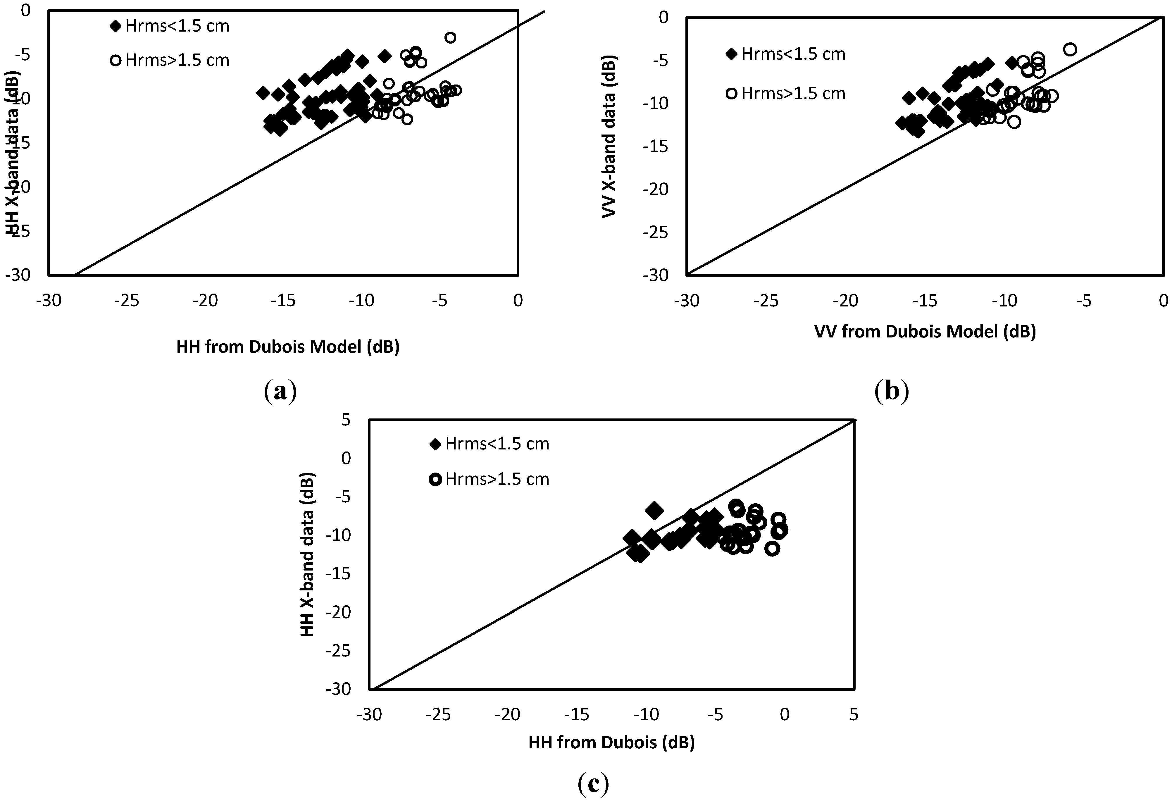
| 36° | Hrms < 1.5 cm | 2.32 | 3.25 | 3.48 | 3.9 |
| Hrms > 1.5 cm | −2.57 | 3.38 | -0.18 | 1.75 | |
| All Hrms | 0.22 | 3.3 | 1.91 | 1.78 | |
| 26° | Hrms < 1.5 cm | −2.19 | 2.85 | ||
| Hrms > 1.5 cm | −6.8 | 7.08 | |||
| All Hrms | −4.6 | 5.49 | |||
| IEM calibrated Model according to Baghdadi et al. [36] | |||||
| 36° (all Hrms) | 0.97 | 1.8 | 0.84 | 1.67 | |
| 26° (all Hrms) | −0.55 | 1.64 | |||
5. Conclusions
Acknowledgments
Author Contributions
Conflicts of Interest
References
- Ulaby, F.T.; Moore, R.K.; Fung, A.K. Microwave Remote Sensing Active and Passive; Artech House, Inc.: Norwood, MA, USA, 1986. [Google Scholar]
- Koster, R.D.; Dirmeyer, P.A.; Guo, Z.; Bonan, G.; Chan, E.; Cox, P.; Gordon, C.T.; Kanae, S.; Kowalczyk, E.; Lawrence, D.; et al. Regions of strong coupling between soil moisture and precipitation. Science 2004, 305, 1138–1140. [Google Scholar]
- Jackson, T.-J.; Schmugge, J.; Engman, E.-T. Remote sensing applications to hydrology: Soil moisture. Hydrol. Sci. 1996, 41, 517–530. [Google Scholar] [CrossRef]
- Moran, M.S.; Hymer, D.C.; Qi, J.; Sano, E.E. Soil moisture evaluation using multi-temporal synthetic aperture radar (SAR) in semiarid rangeland. Agric. For. Meteorol. 2000, 105, 69–80. [Google Scholar] [CrossRef]
- Zribi, M.; Saux-Picart, S.; André, C.; Descroix, L.; Ottlé, O.; Kallel, A. Soil moisture mapping based on ARSAR/ENVISAT radar data over a sahelian site. Int. J. Remote Sens. 2006, 28, 3547–3565. [Google Scholar] [CrossRef]
- Marticorena, B.; Kardous, M.; Bergametti, G.; Callot, Y.; Chazette, P.; Khatteli, H.; Le Hégarat-Mascle, S.; Maillé, M.; Rajot, J.L.; Vidal Madjar, D.; et al. Geometric and aerodynamic surface roughness in southern Tunisia and their relation with radar backscatter coefficient. J. Geophys. Res. 2006. [Google Scholar] [CrossRef]
- Paloscia, S.; Pampaloni, P.; Pettinato, S.; Santi, E. A comparison of algorithms for retrieving soil moisture from ENVISAT/ASAR images. IEEE Trans. Geosci. Remote Sens. 2008, 46, 3274–3284. [Google Scholar] [CrossRef]
- Rahman, M.M.; Moran, M.S.; Thoma, D.P.; Bryant, R.; Holifield Collins, C.D.; Jackson, T.; Orr, B.J.; Tischler, M. Mapping surface roughness and soil moisture using multi-angle radar imagery without ancillary data. Remote Sens. Environ. 2008, 112, 391–402. [Google Scholar] [CrossRef]
- Zribi, M.; Chahbi, A.; Lili Chabaane, Z.; Duchemin, B.; Baghdadi, N.; Amri, R.; Chehbouni, A. Soil surface moisture estimation over a semi-arid region using ENVISAT ASAR radar data for soil evaporation evaluation. Hydrol. Earth Syst. Sci. 2011, 15, 345–358. [Google Scholar] [CrossRef]
- Baghdadi, N.; Zribi, M.; Loumagne, C.; Ansart, P.; Anguela, T.P. Analysis of TerraSAR-X data and their sensitivity to soil surface parameters over bare agricultural fields. Remote Sens. Environ. 2008, 112, 4370–4379. [Google Scholar] [CrossRef]
- Aubert, M.; Baghdadi, N.; Zribi, M.; Douaoui, A.; Loumagne, C.; Baup, F.; El Hajj, M.; Garrigues, S. Analysis of TerraSAR-X data sensitivity to bare soil moisture, roughness, composition and soil crust. Remote Sens. Environ. 2011, 115, 1801–1810. [Google Scholar] [CrossRef]
- Anguela, T.P.; Zribi, M.; Baghdadi, N.; Loumagne, C. Analysis of local variation of soil surface parameters with TerraSAR-X radar data over bare agricultural fields. IEEE Trans. Geosci. Remote Sens. 2010, 48, 874–881. [Google Scholar] [CrossRef]
- Fung, A.K.; Li, Z.; Chen, K.S. Backscattering from a randomly rough dielectric surface. IEEE Trans. Geosci. Remote Sens. 1992, 30, 356–369. [Google Scholar] [CrossRef]
- Fung, A.K. Microwave Scattering and Emission Models and Their Applications; Artech House: Boston, MA, USA, 1994. [Google Scholar]
- Chen, K.S.; Wu, T.D.; Tsang, L.; Li, Q.; Shi, J.; Fung, A.K. Emission of rough surfaces calculated by the integral equation method with comparison to three-dimensional moment method simulations. IEEE Trans. Geosci. Remote Sens. 2003, 41, 90–101. [Google Scholar] [CrossRef]
- Wu, T.D.; Chen, K.S. A reappraisal of the validity of the IEM model for backscattering from rough surfaces. IEEE Trans. Geosci. Remote Sens. 2004, 42, 743–753. [Google Scholar] [CrossRef]
- Oh, Y.; Sarabandi, K.; Ulaby, F.T. An empirical model and an inversion technique for radar scattering from bare soil surfaces. IEEE Trans. Geosci. Remote Sens. 1992, 30, 370–382. [Google Scholar] [CrossRef]
- Dubois, P.; Van Zyl, J.; Engman, T. Measuring soil moisture with imaging radars. IEEE Trans. Geosci. Remote Sens. 1995, 33, 915–926. [Google Scholar] [CrossRef]
- Wu, T.D.; Chen, K.S.; Shi, J.; Fung, A.K. A transition model for the reflection coefficient in surface scattering. IEEE Trans. Geosci. Remote Sens. 2001, 39, 2040–2050. [Google Scholar] [CrossRef]
- Li, Q.; Shi, J.C.; Chen, K.S. A generalised power law spectrum and its applications to the backscattering of soil surfaces based on the integral equation model. IEEE Trans. Geosci. Remote Sens. 2002, 40, 271–281. [Google Scholar] [CrossRef]
- Le Morvan, A.; Zribi, M.; Baghdadi, N.; Chanzy, A. Soil moisture profile effect on radar signal measurement. Sensors 2008, 8, 256–270. [Google Scholar] [CrossRef]
- Shi, J.; Wang, J.; Hsu, A.Y.; O’Neill, P.E.; Engman, E.T. Estimation of bare surface soil moisture surface roughness parameter using L-band SAR image data. IEEE Trans. Geosci. Remote Sens. 1997, 35, 1254–1265. [Google Scholar] [CrossRef]
- Mattia, F.; Le Toan, T. Backscattering properties of multi-scale rough surfaces. J. Electro. Waves Appl. 1999, 13, 491–526. [Google Scholar]
- Davidson, M.W.; Le Toan, T.; Mattia, F.; Satalino, G.; Manninen, T.; Borgeaud, M. On the characterization of agricultural soil roughness for radar remote sensing studies. IEEE Trans. Geosci. Remote Sens. 2000, 38, 630–640. [Google Scholar] [CrossRef]
- Mattia, F.; Davidson, M.W.J.; Le Toan, T.; D’Haese, C.M.F.; Verhoest, N.E.C; Gatti, A.M.; Borgeaud, M. A Comparison between soil roughness statistics used in surface scattering models derived from mechanical and laser profilers. IEEE Trans. Geosci. Remote Sens. 2003, 41, 1659–1671. [Google Scholar] [CrossRef]
- Zribi, M.; Ciarletti, V.; Taconet, O. Validation of a rough surface model based on fractional brownian geometry with SIRC and ERASME radar data over Orgeval site. Remote Sens. Environ. 2000, 73, 65–72. [Google Scholar] [CrossRef]
- Callens, M.; Verhoest, N.E.C.; Davidson, M.W.J. Parameterization of tillage-induced single-scale soil roughness from 4-m profiles. IEEE Trans. Geosci. Remote Sens. 2006, 44, 878–888. [Google Scholar] [CrossRef]
- Verhoest, N.E.C.; Lievens, H.; Wagner, W.; Alvarez-Mozos, J.; Moran, M.S.; Mattia, F. On the soil roughness parameterization problem in soil moisture retrieval of bare surfaces from Synthetic Aperture Radar. Sensors 2008, 8, 4213–4248. [Google Scholar] [CrossRef]
- Lievens, H.; Vernieuwe, H.; Alvarez-Mozos, J.; de Baets, B.; Verhoest, N.E.C. Error in SAR-derived soil moisture due to roughness parameterization: An analysis based on synthetical surface profiles. Sensors 2009, 9, 1067–1093. [Google Scholar] [CrossRef] [PubMed]
- Lievens, H.; Verhoest, N.E.C.; de Keyser, E.; Vernieuwe, H.; Matgen, P.; Álvarez-Mozos, J.; de Baets, B. Effective roughness modelling as a tool for soil moisture retrieval from C- and L-band SAR. Hydrol. Earth Syst. Sci. 2011, 15, 151–162. [Google Scholar] [CrossRef]
- Zribi, M.; Dechambre, M. A new empirical model to retrieve soil moisture and roughness from radar data. Remote Sens. Environ. 2003, 84, 42–52. [Google Scholar] [CrossRef]
- Zribi, M.; Gorrab, A.; Baghdadi, N. A new soil roughness parameter for the modelling of radar backscattering over bare soil. Remote Sens. Environ. 2014, 152, 62–73. [Google Scholar] [CrossRef]
- Baghdadi, N.; Gherboudj, I.; Zribi, M.; Sahebi, M.; Bonn, F.; King, C. Semi-empirical calibration of the IEM backscattering model using radar images and moisture and roughness field measurements. Int. J. Remote Sens. 2004, 25, 3593–3623. [Google Scholar] [CrossRef]
- Baghdadi, N.; Holah, N.; Zribi, M. Calibration of the integral equation model for SAR data in C-band and HH and VV polarizations. Int. J. Remote Sens. 2006, 27, 805–816. [Google Scholar] [CrossRef]
- Baghdadi, N.; Abou Chaaya, J.; Zribi, M. Semi-empirical calibration of the integral quation model for SAR data in C-band and cross polarization using radar images and field measurements. IEEE Geosci. Remote Sens. Lett. 2011, 8, 14–18. [Google Scholar] [CrossRef]
- Baghdadi, N.; Saba, E.; Aubert, M.; Zribi, M.; Baup, F. Evaluation of radar backscattering models IEM, Oh, and Dubois for SAR data in X-band over bare soils. IEEE Geosci. Remote Sens. Lett. 2011, 8, 1160–1164. [Google Scholar] [CrossRef]
- Macelloni, G.; Paloscia, S.; Pampaloni, P.; Sigismondi, S.; de Matthaeis, P.; Ferrazzoli, P.; Schiavon, G.; Solimini, D. The SIR-C/X-SAR experiment on Montespertoli: Sensitivity to hydrological parameters. Int. J. Remote Sens. 1999, 20, 2597–2612. [Google Scholar] [CrossRef]
- Baghdadi, N.; El Hajj, M.; Dubois, P.; Zribi, M.; Belaud, G.; Cheviron, B. Signal level comparison between TerraSAR-X and COSMO-SkyMed SAR sensors. IEEE Geosci. Remote Sens. Lett. 2015, 12, 448–452. [Google Scholar] [CrossRef]
- Pettinato, S.; Santi, E.; Paloscia, S.; Pampaloni, P.; Fontanelli, G. The intercomparison of X-band SAR images from COSMO-SkyMed and TerraSAR-X satellites: Case studies. Remote Sens. 2013, 5, 2928–2942. [Google Scholar] [CrossRef]
- Zribi, M.; Ciarletti, V.; Taconet, O.; Vidal-Madjar, D. Effect of rows structure on radar microwave measurements over soil surface. Int. J. Remote Sens. 2002, 23, 5211–5224. [Google Scholar] [CrossRef]
- Zribi, M.; Baghdadi, N.; Holah, N.; Fafin, O.; Guérin, C. Evaluation of a rough soil surface description with ASAR-ENVISAT Radar Data. Remote Sens. Environ. 2005, 95, 67–76. [Google Scholar] [CrossRef]
© 2015 by the authors; licensee MDPI, Basel, Switzerland. This article is an open access article distributed under the terms and conditions of the Creative Commons Attribution license (http://creativecommons.org/licenses/by/4.0/).
Share and Cite
Gorrab, A.; Zribi, M.; Baghdadi, N.; Mougenot, B.; Chabaane, Z.L. Potential of X-Band TerraSAR-X and COSMO-SkyMed SAR Data for the Assessment of Physical Soil Parameters. Remote Sens. 2015, 7, 747-766. https://doi.org/10.3390/rs70100747
Gorrab A, Zribi M, Baghdadi N, Mougenot B, Chabaane ZL. Potential of X-Band TerraSAR-X and COSMO-SkyMed SAR Data for the Assessment of Physical Soil Parameters. Remote Sensing. 2015; 7(1):747-766. https://doi.org/10.3390/rs70100747
Chicago/Turabian StyleGorrab, Azza, Mehrez Zribi, Nicolas Baghdadi, Bernard Mougenot, and Zohra Lili Chabaane. 2015. "Potential of X-Band TerraSAR-X and COSMO-SkyMed SAR Data for the Assessment of Physical Soil Parameters" Remote Sensing 7, no. 1: 747-766. https://doi.org/10.3390/rs70100747
APA StyleGorrab, A., Zribi, M., Baghdadi, N., Mougenot, B., & Chabaane, Z. L. (2015). Potential of X-Band TerraSAR-X and COSMO-SkyMed SAR Data for the Assessment of Physical Soil Parameters. Remote Sensing, 7(1), 747-766. https://doi.org/10.3390/rs70100747


