Crop Condition Assessment with Adjusted NDVI Using the Uncropped Arable Land Ratio


Abstract
:1. Introduction
2. Data and Study Area
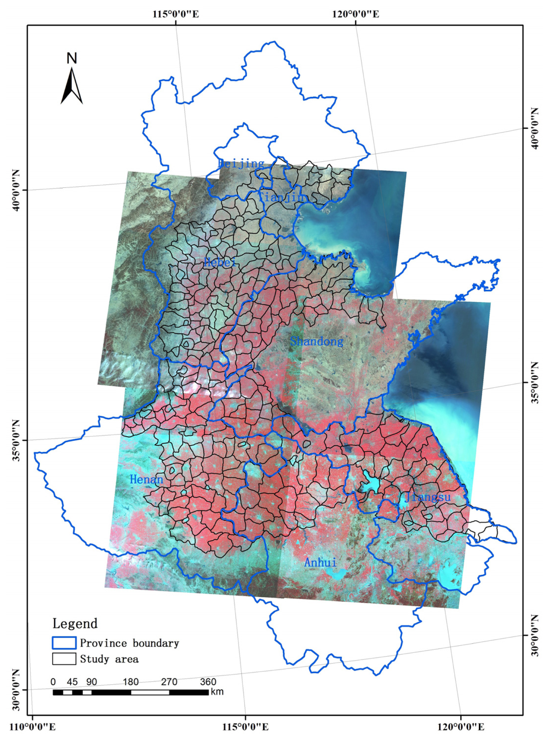
2.1. Site Description
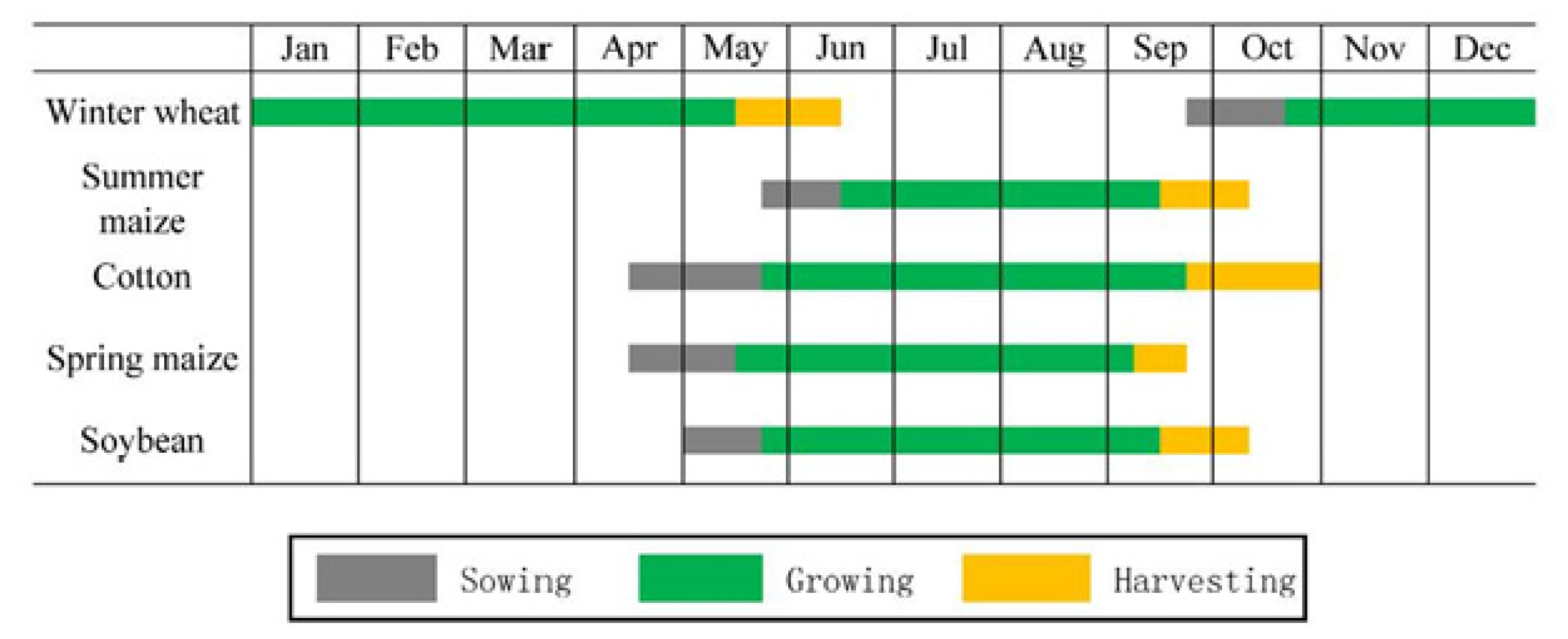
2.2. Field Survey
2.3. Remote Sensing Data
2.4. Auxiliary Data
3. Method
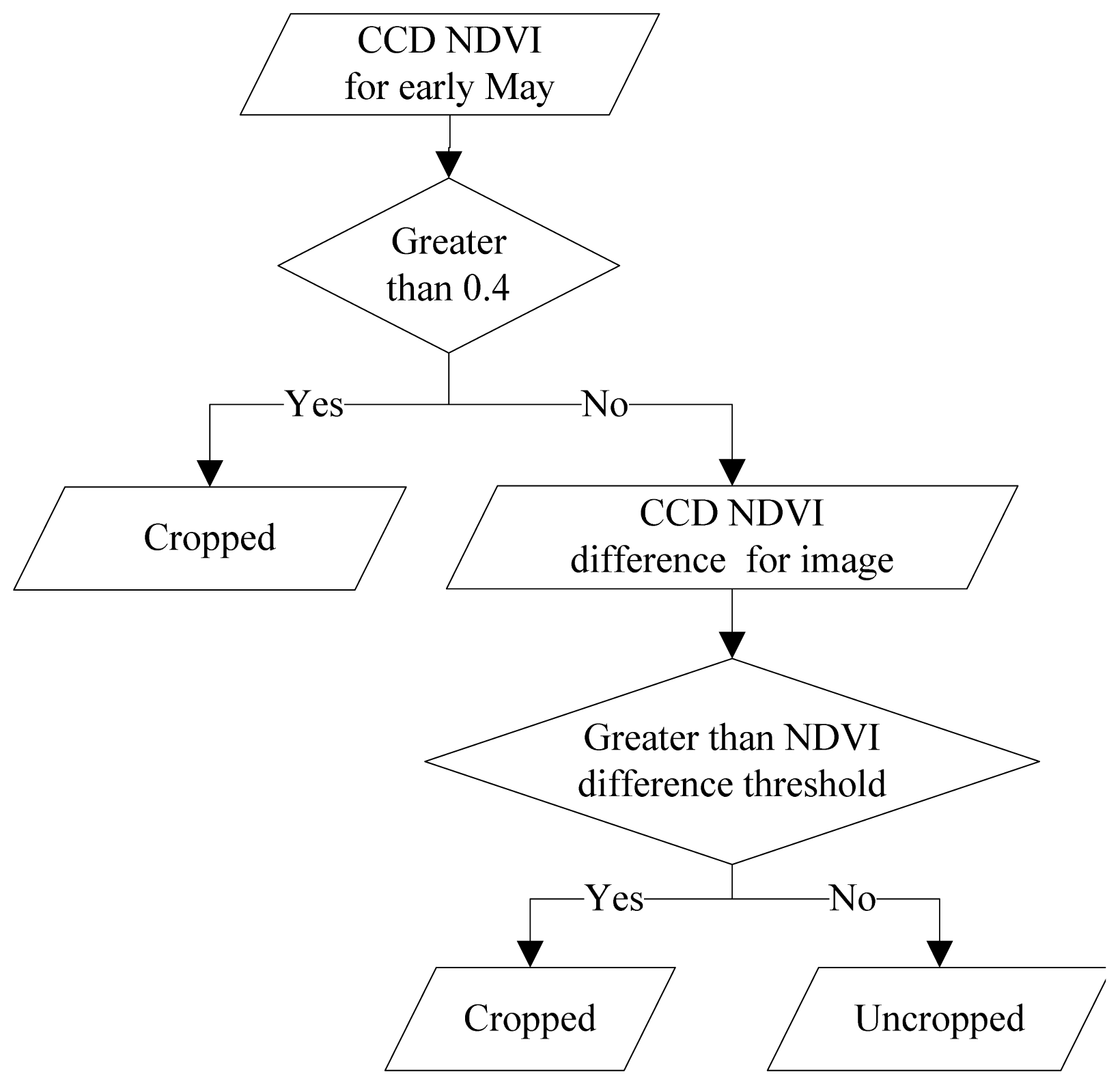
3.1. Uncropped Arable Land Ratio (UALR) Derivation
3.2. Linear Spectral Unmixing Using UALR
3.3. Crop Condition Monitoring Method
4. Results
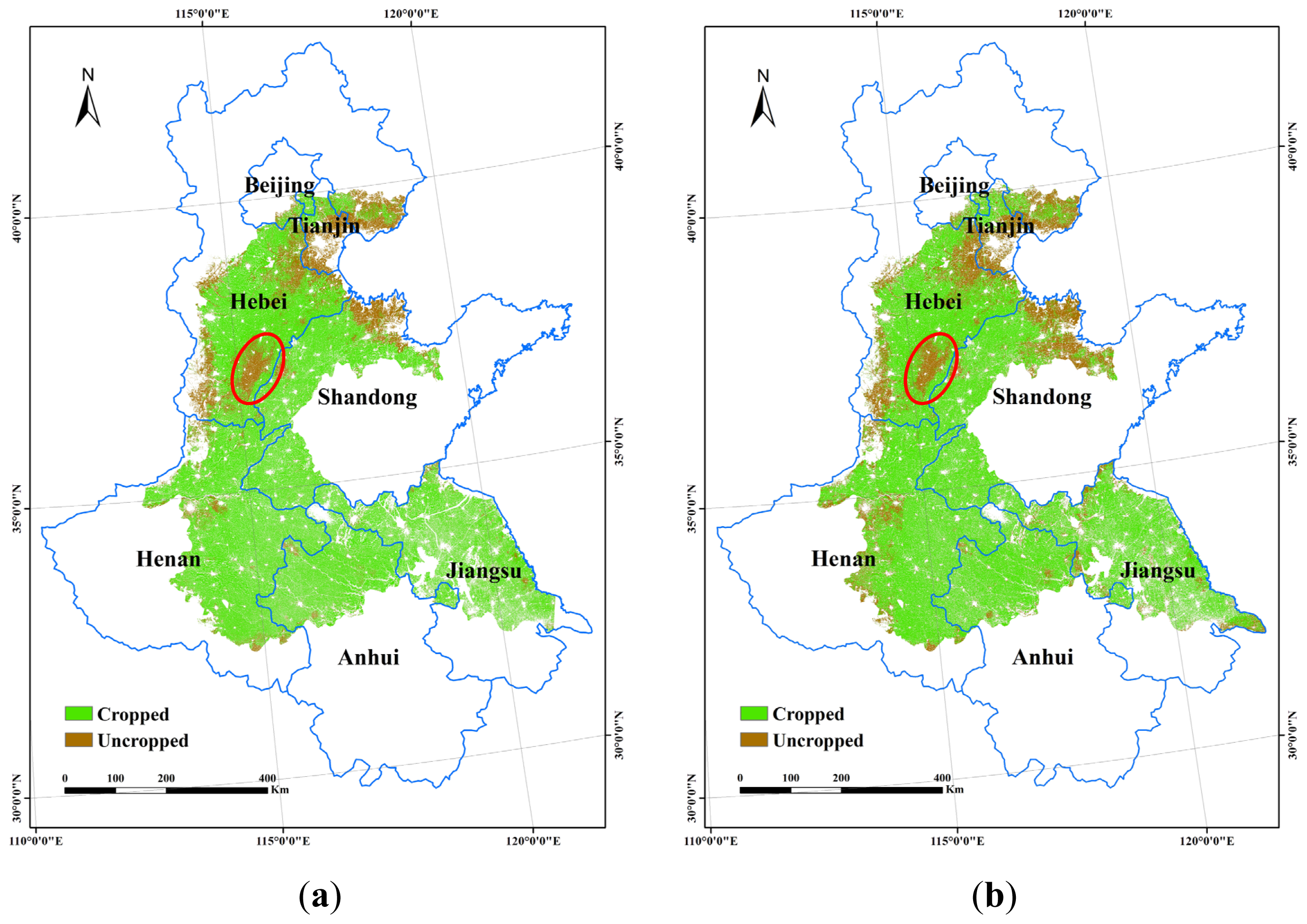
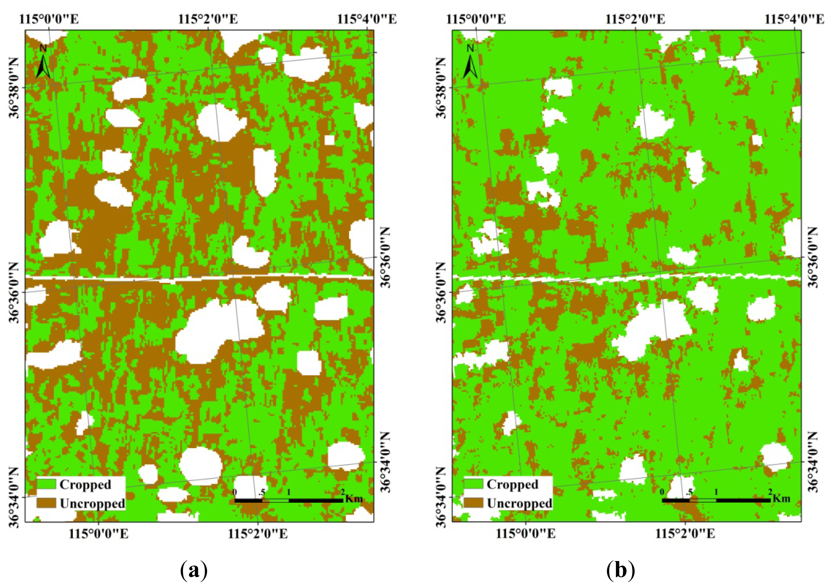
4.1. Cropped and Uncropped Arable Land Mapping and Accuracy Evaluation
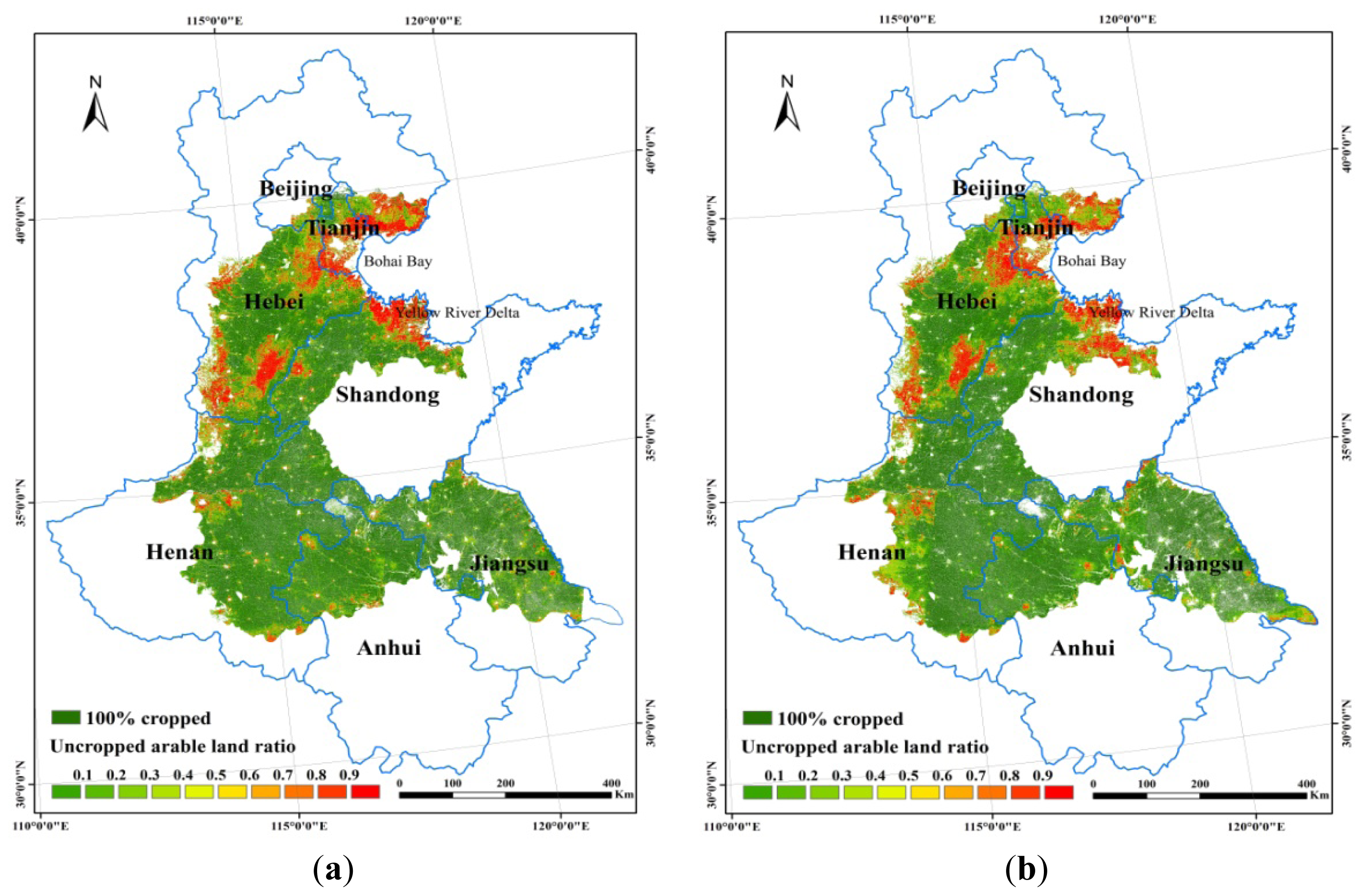
4.2. Uncropped Arable Land Ratio
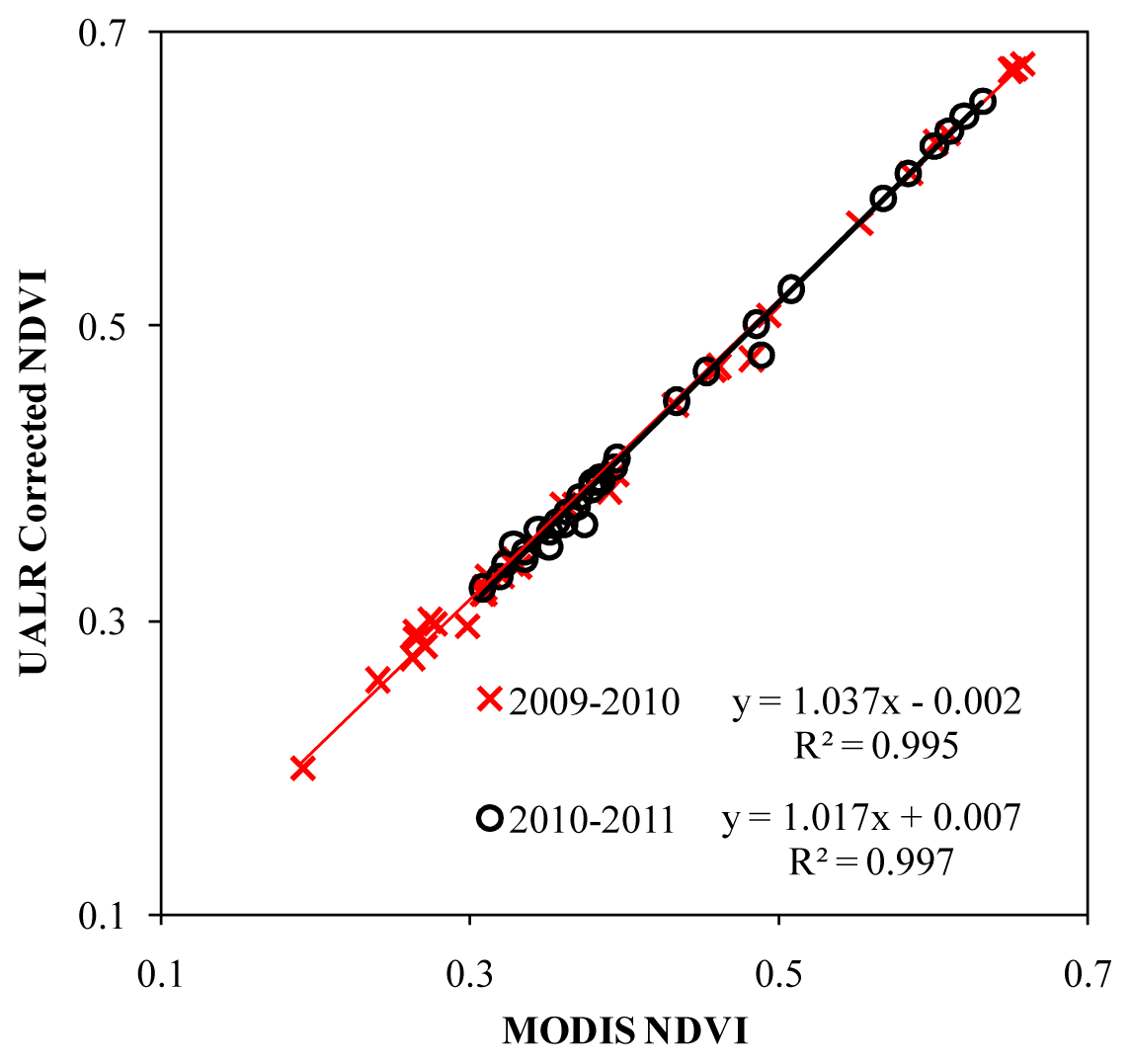
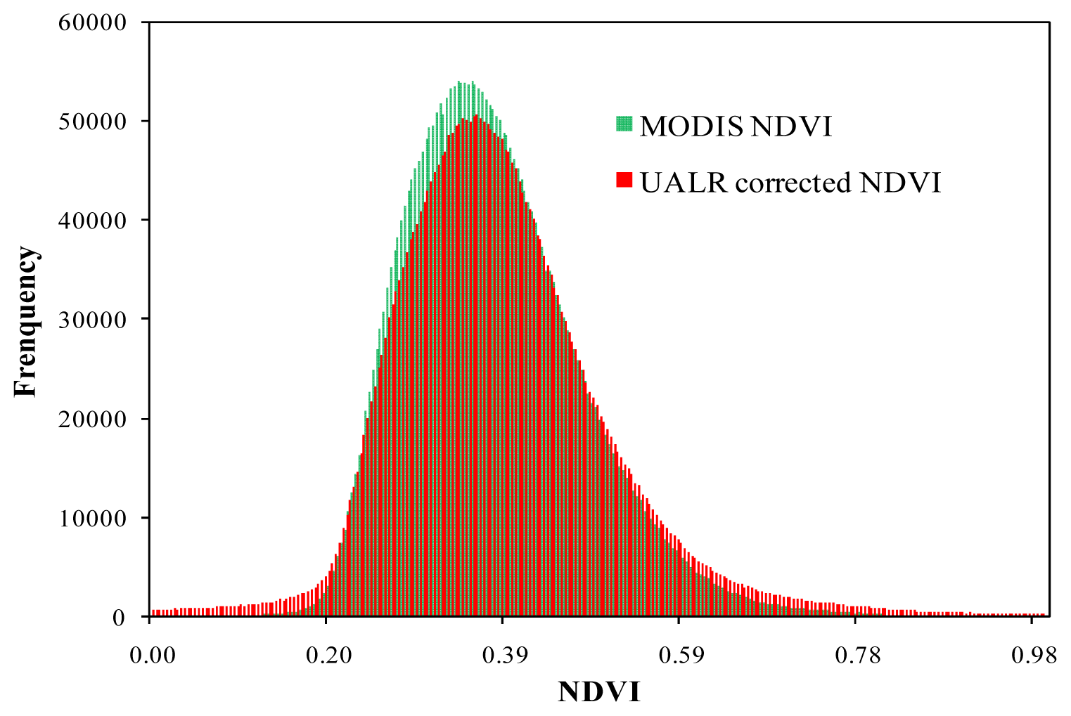
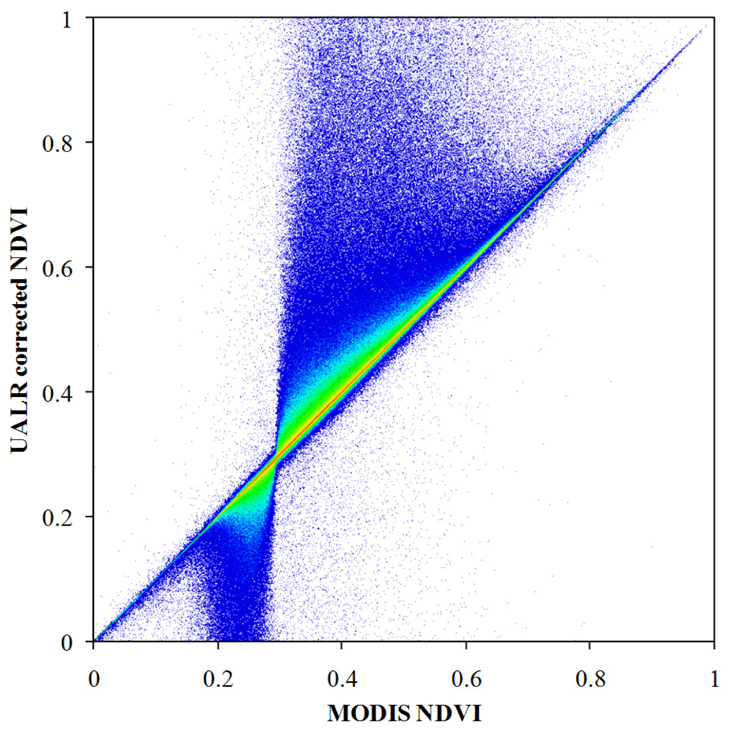
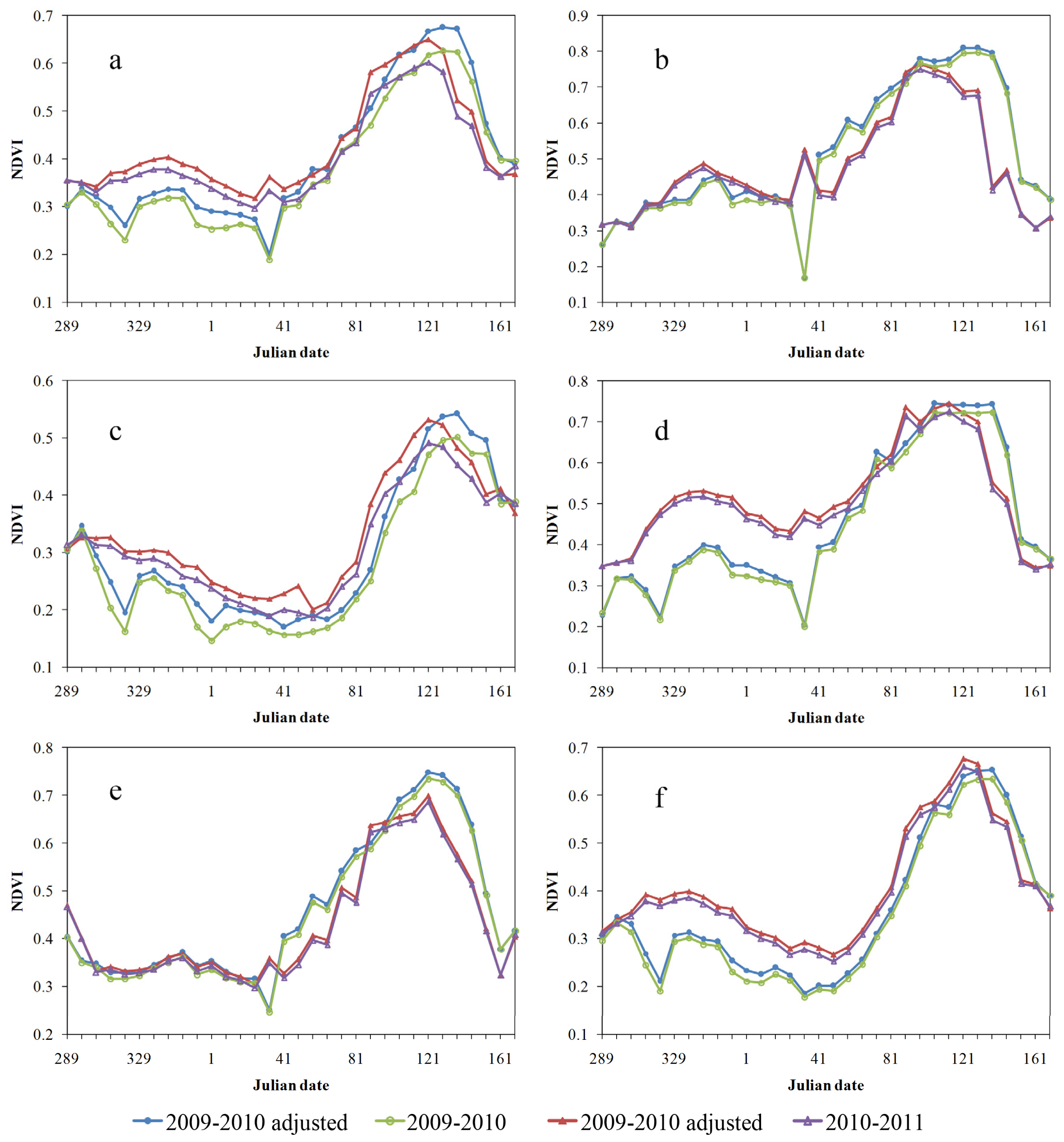
4.3. UALR-Adjusted NDVI vs. MODIS NDVI
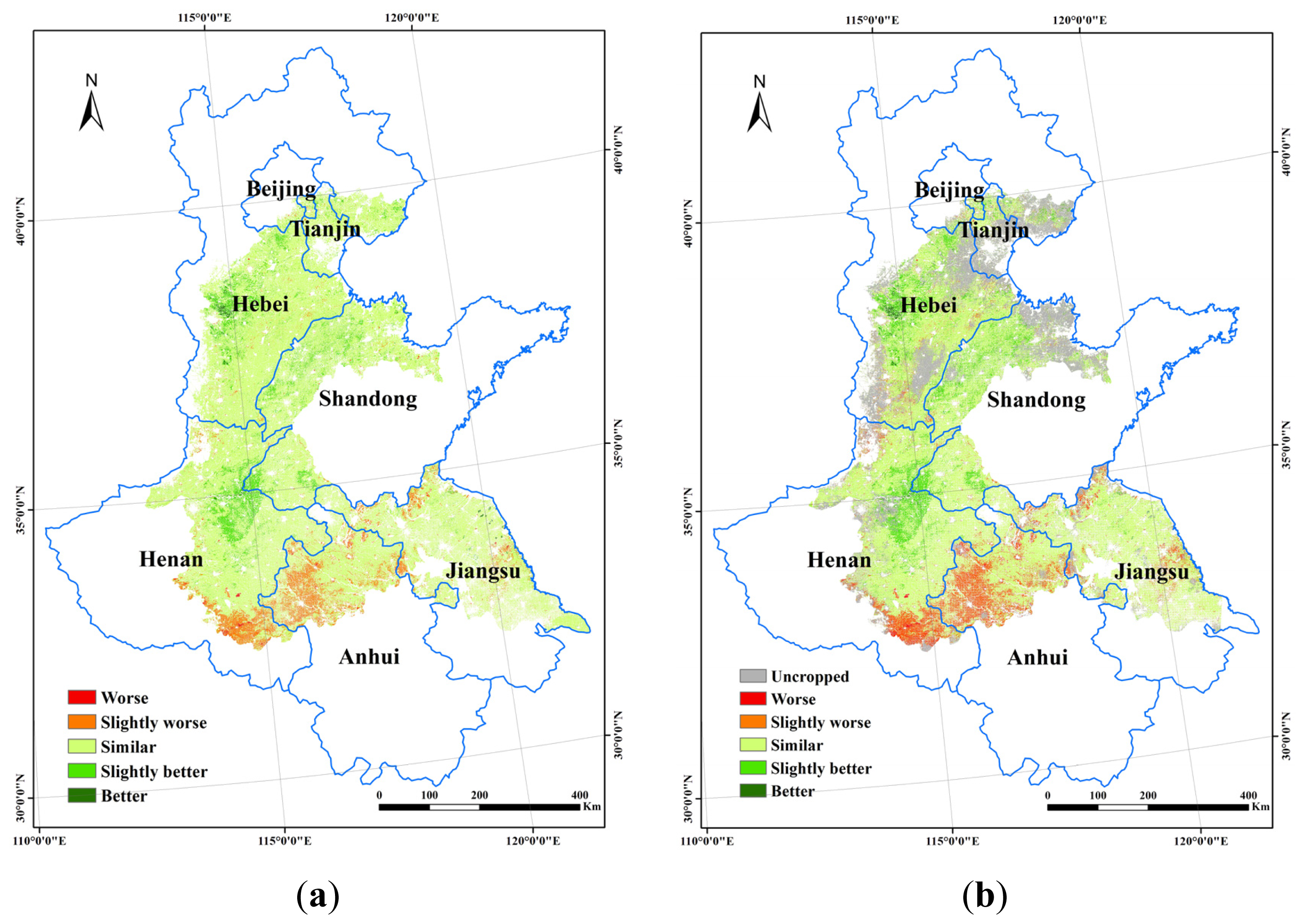
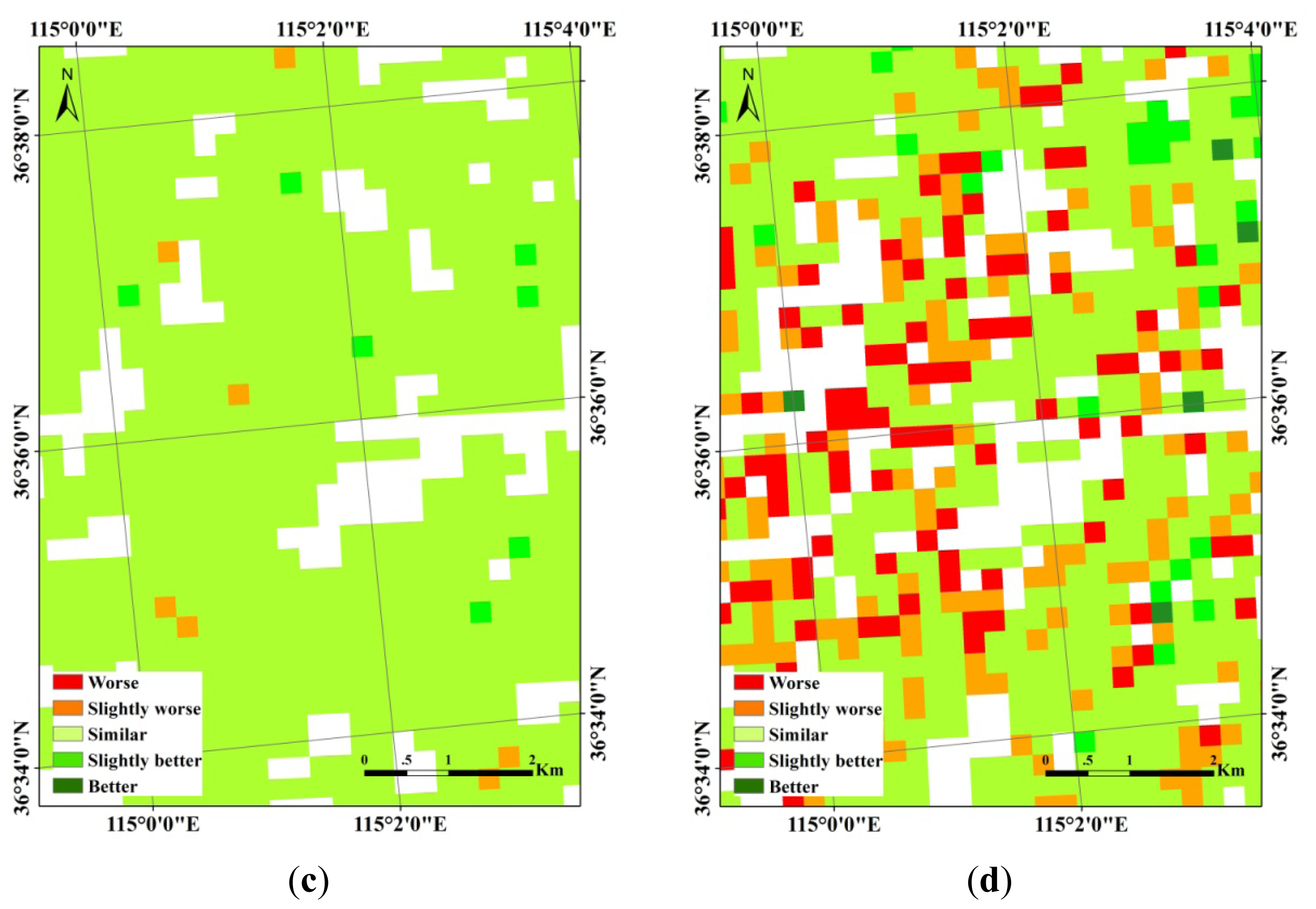
4.4. Crop Condition Assessment Result
5. Discussion
5.1. Highlighted Difference by Using UALR-Adjusted NDVI and MODIS NDVI
5.2. Advantages and Shortcomings
6. Conclusions
Acknowledgments
Conflicts of Interest
- Author ContributionsBingfang Wu, the corresponding author, brings us the concept of the proposed method and mainly contributes to the discussion section. Miao Zhang writes up introduction, data, method and conclusion sections. Miao Zhang, together with Mingzhao Yu, Wentao Zou and Yang Zheng write up the method and results sections. Data processing and results analysis are done together by all the listed authors.
References
- Meng, J.H.; Wu, B.F. Study on the crop condition monitoring methods with remote sensing. Remote Sens. Spat. Inf. Sci 2008, 37, 945–950. [Google Scholar]
- Jayne, T.S.; Rashid, S. The Value of Accurate Crop Production Forecasts. Proceedings of Fourth African Agricultural Markets Program (AAMP) Policy Symposium, Lilongwe, Malawi, 6–10 September 2010.
- Becker-Reshef, I.; Justice, C.; Sullivan, M.; Vermote, E.; Tucker, C.; Anyamba, A.; Small, J.; Pak, E.; Masuoka, E.; Schmaltz, J.; et al. Monitoring global croplands with coarse resolution earth observations: The Global Agriculture Monitoring (GLAM) Project. Remote Sens 2010, 2, 1589–1609. [Google Scholar]
- Wu, B.F.; Meng, J.H.; Li, Q.Z.; Yan, N.N.; Du, X.; Zhang, M. Remote sensing-based global crop monitoring: Experiences with China’s cropwatch system. Int. J. Digit. Earth 2014, 7, 113–137. [Google Scholar]
- System Description of the WOFOST 6.0 Crop Growth Simulation Model Implemented in CGMS; Supit, I.; Hooijer, A.A.; van Diepen, C.A. (Eds.) Joint Research Centre (JRC): Brussels, Belgium, 1994.
- Vossen, P.; Rijks, D. Early Crop Yield Assessment of the EU Countries: The System Implemented by the Joint Research Centre; Joint Research Centre (JRC): Brussels, Belgium, 1995. [Google Scholar]
- Genovese, G. Introduction to the MARS Crop Yield Forecasting System, Document of the Working Party of the Statistics of Crop Products from the Agriculture Statistics Committee; Research Centre (JRC): Brussels, Belgium, 2001. [Google Scholar]
- Genovese, G.P.; Fritz, S.; Bettio, M. A comparison and evaluation of performances among crop yield forecasting models based on remote sensing: Results from the geoland observatory of food monitoring. Int. Arch. Photogramm. Remote Sens. Spacial Inf. Sci 2006, 36, 71–77. [Google Scholar]
- Duveiller, G.; Lopez-Lozano, R.; Baruth, B. Enhanced processing of 1-km spatial resolution fAPAR time series for sugarcane yield forecasting and monitoring. Remote Sens 2013, 5, 1091–1116. [Google Scholar]
- FAO Global Information and Early Warning on Food and Agriculture (GIEWS). Available online: http://www.fao.org/giews/english/index.htm (accessed on 13 June 2014).
- Famine Early Warning Systems Network. Available online: http://www.fews.net/about-us (accessed on 13 June 2014).
- Space Applications Centre, Manual for Crop Production Forecasting Using Remotely Sensed Data; A Joint Project of Space and Ministry of Agriculture, Govt. of India, Technical Note, RSAF/SAC/CAPE-II/TN/46/95; Space Applications Centre: Ahmedabad, India, 1995.
- Reichert, G.C.; Caissy, D. A. Reliable Crop Condition Assessment Program (CCAP) Incorporating NOAA AVHRR Data, a Geographical Information System and the Internet, 2002. Available online: http://proceedings.esri.com/library/userconf/proc02/pap0111/po111.htm (accessed on 6 June 2014).
- Fontana, D.C.; Melo, R.W.; Wagner, A.P.L.; Weber, E.; Gusso, A. Use of Remote Sensing for Crop Yield and Area Estimates in the Southern of Brazil. Proceedings of ISPRS Archives XXXVI-8/W48 Workshop Remote Sensing Support to Crop Yield and Area Estimates, Stresa, Italy; 2006. [Google Scholar]
- Satellite Data Availability, Methods and Challenges for the Assessment Of Climate Change and Variability Impacts on Agriculture; Toulios, L.; Stancalie, G. (Eds.) European Science Foundation: Strasbourg, France, 2010.
- Wu, B.F.; Meng, J.H.; Li, Q.Z. An integrated crop condition monitoring system with remote sensing. Trans. ASABE 2010, 53, 971–979. [Google Scholar]
- Wu, B.F. Operational remote sensing methods for agricultural statistics. Acta Geogr. Sin 2000, 55, 23–35. [Google Scholar]
- Esquerdo, J.C.D.M.; Zullo, J.J.; Antunes, J.F.G. Use of NDVI/AVHRR time-series profiles for soybean crop monitoring in Brazil. Int. J. Remote Sens 2011, 32, 3711–3727. [Google Scholar]
- Justice, C.O. Monitoring the grasslands of semi-arid Africa using NOAA-AVHRR data. Adv. Space Res 1986, 13, 219–222. [Google Scholar]
- Huete, A.; Justice, C.; Liu, H. Development of vegetation and soil indices for MODIS-EOS. Remote Sens. Environ 1994, 49, 224–234. [Google Scholar]
- Moran, M.S.; Inoue, Y.; Barnes, E.M. Opportunities and limitations for image-based remote sensing in precision crop management. Remote Sens. Environ 1997, 61, 319–346. [Google Scholar]
- Genovese, G.; Vignolles, C.; Nègre, T.; Passera, G. A methodology for a combined use of normalised difference vegetation index and CORINE land cover data for crop yield monitoring and forecasting. A case study on Spain. Agronomie 2001, 21, 91–111. [Google Scholar]
- Papadavid, G.; Fasoula, D.; Hadjimitsis, M.; Perdikou, P.S.; Hadjimitsis, D.G. Image based remote sensing method for modeling black-eyed beans (Vigna unguiculata) Leaf Area Index (LAI) and Crop Height (CH) over Cyprus. Cent. Eur. J. Geosci 2013, 5, 1–11. [Google Scholar]
- Domrnikiotis, C.; Spiliotopoulos, M.; Tsiros, E.; Dalezios, N.R. Early cotton production assessment in Greece based on the combination of the drought vegetation condition index (VCI) and Bhalme and Mooley Drought Index (BMDI). Int. J. Remote Sens 2004, 25, 5373–5388. [Google Scholar]
- Meng, J.H. Research to Crop Growth Monitoring Indicators with Remote Sensing. Ph.D. Thesis, Chinese Academy of Sciences, Beijing, China, 2006. [Google Scholar]
- Yang, Z.W.; Di, L.P.; Yu, G.P.; Chen, Z.Q. Vegetation Condition Indices for Crop Vegetation Condition Monitoring. Proceedings of the 2001 IEEE International Geoscience and Remote Sensing Symposium (IGARSS), Vancouver, BC, Canada, 24–29 July 2011; pp. 3534–3537.
- Wu, B.F.; Zhang, M.; Zeng, H.W.; Liu, G.S.; Chang, S.; Gommes, R. New Indicators for Global Crop Monitoring in CropWatch—Case Study in North China Plain. Proceedings of the 35th International Symposium on Remote Sensing of Environment, Beijing, China, 22–26 April 2013.
- Liu, S.; Mo, X.; Lin, Z.; Xu, Y.; Ji, J.; Wen, G.; Richey, J. Crop yield responses to climate change in the Huang-Huai-Hai Plain of China. Agric. Water Manag 2010, 97, 1195–1209. [Google Scholar]
- Shi, X.Z.; Yu, D.S.; Warner, E.D.; Sun, W.X.; Petersen, G.W.; Gong, Z.T.; Lin, H. Cross-reference system for translating between genetic soil classification of China and soil taxonomy. Soil Sci. Soc. Am. J 2006, 70, 78–83. [Google Scholar]
- Grieser, J.; Gommes, R.; Bernardi, M. New_locClim, the Local Climate Estimator of FAO. Geophysical Research Abstracts. 2001, p. 08305. Available online: ftp://ext-ftp.fao.org/SD/Reserved/Agromet/New_LocClim/ (accessed on 6 June 2014).
- Zhang, M.W.; Zhou, Q.B.; Chen, Z.X.; Liu, J.; Zhou, Y.; Cai, C.F. Crop discrimination in Northern China with double cropping systems using Fourier analysis of time-series MODIS data. Int. J. Appl. Earth Obs 2008, 10, 476–485. [Google Scholar]
- Zhang, M.; Wu, B.F.; Meng, J.H.; Dong, T.F.; You, X.Z. Fallow Land Mapping for Better Crop Monitoring in Huang-Huai-Hai Plain Using HJ-1 CCD Data. Proceedings of the 35th International Symposium on Remote Sensing of Environment, Beijing, China, 22–26 April 2013.
- China Centre for Resource Satellite Data and Application, Technical Specification of Payloads of HJ-1A/1B/1C. Available online: http://www.cresda.com/n16/n92006/n92066/n98627/index.html (accessed on 13 June 2014).
- Reverb ECHO, NASA’s Earth Observation System Data and Information System (EOSDIS). Available online: http://reverb.echo.nasa.gov (accessed on 13 June 2014).
- Wu, B.F.; Zhang, L.; Yan, C.Z.; Wang, Z.M. China Cover 2010: Methodology and Features. Proceedings of 2010 GeoInformatics, Hong Kong, China, 15–17 June 2012.
- Li, M.M.; Wu, B.F.; Yan, C.Z.; Zhou, W.F. Estimation of vegetation fraction in the upper basin of Miyun reservoir by remote sensing. Res. Sci 2004, 26, 153–159. [Google Scholar]
- Jing, X.; Yao, W.Q.; Wang, J.H.; Song, X.Y. A study on the relationship between dynamic change of vegetation coverage and precipitation in Beijing’s mountainous areas during the last 20 years. Math. Comput. Model 2011, 54, 1079–1085. [Google Scholar]
- Sellers, P.J.; Tucker, C.J.; Collatz, G.J.; Los, S.O.; Justice, C.O.; Dazlich, D.A.; Randall, D.A. A revised land surface parameterization (SiB2) for atmospheric GCMs. Part II: The generation of global fields of terrestrial biophysical parameters from satellite data. J. Clim 1996, 9, 706–737. [Google Scholar]
- Gutman, G.; Ignatov, A. The derivation of the green vegetation fraction from NOAA/AVHRR data for use in numerical weather prediction models. Int. J. Remote Sens 1998, 19, 1533–1543. [Google Scholar]
- Zeng, X.; Dickinson, R.E.; Walker, A.; Shaikh, M.; DeFries, R.S.; Qi, J. Derivation and evaluation of global 1-km fractional vegetation cover data for land modeling. J. Appl. Meteorol 2000, 39, 826–839. [Google Scholar]
- Congalton, R.G.; Green, K. Assessing the Accuracy of Remotely Sensed Data: Principles and Practices; Lewis Publishers: Boca Raton, FL, USA, 1999. [Google Scholar]
- Meng, J.H.; Wu, B.F.; Li, Q.Z. A global crop growth monitoring system based on remote sensing. Int. Arch. Photogramm. Remote Sens. Spatial Inf. Sci 2008, XXXVII, 1695–1698. [Google Scholar]
- Guo, W.; Wang, R.; Zhou, S.; Zhang, S.; Zhang, Z. Genetic diversity and clonal structure of Phragmites australis in the Yellow River delta of China. Biochem. Syst. Ecol 2003, 31, 1093–1109. [Google Scholar]
- Kastens, J.H.; Kastens, T.L.; Kastens, D.L.; Price, K.P.; Martinko, E.A.; Lee, R.Y. Image masking for crop yield forecasting using AVHRR NDVI time series imagery. Remote Sens. Environ 2005, 99, 341–356. [Google Scholar]
- Cheng, W.F.; Zhou, Y.; Wang, S.X.; Han, Y.; Wang, F.T.; Pu, Q.Y. Study on the method of recognizing abandoned farmlands based on multispectral remote sensing. Spectrosc. Spect. Anal 2011, 31, 1615–1620. [Google Scholar]
- Zhang, M.; Li, Q.Z.; Wu, B.F. Investigating the Capability of Multitemporal Landsat Images for Crop Identification in High Farmland Fragmentation Regions. Proceedings of the 2012 First International Conference on Agro-Geoinformatics (Agro-Geoinformatics), Shanghai, China, 2–4 August 2012.
- Peña-Barragán, J.M.; Ngugi, M.K.; Plant, R.E.; Six, J. Object-based crop identification using multiple vegetation indices, textural features and crop phenology. Remote Sens. Environ 2011, 115, 1301–1316. [Google Scholar]
- Asner, G.P. Cloud cover in Landsat observations of the Brazilian Amazon. Int. J. Remote Sens 2001, 22, 3855–3862. [Google Scholar]

| Items | Anhui | Beijing | Hebei | Henan | Jiangsu | Shandong | Tianjin |
|---|---|---|---|---|---|---|---|
| Longitude (Degree) * | 116.66 | 116.56 | 115.87 | 114.73 | 119.27 | 116.56 | 117.37 |
| Latitude (Degree) * | 33.41 | 39.72 | 38.41 | 34.27 | 33.56 | 36.91 | 39.31 |
| Altitude (m) | 20 | 20 | 0 | 40 | 0 | 0 | 0 |
| Kōppen climate class | BSk | Dwa | BSk | Cwa | Cwa | BSk | Dwa |
| Kōppen Climate description | Cold arid steppe climate | Snow climate with dry winter and hot summer | Cold arid steppe climate | Warm temperate with dry winter and hot summer | Warm temperate with dry winter and hot summer | Cold arid steppe climate | Snow climate with dry winter and hot summer |
| Budyko radiation dryness | 2.574 | 1.881 | 2.932 | 1.615 | 1.299 | 2.653 | 2.001 |
| Budyko runoff (%) | 5.9 | 11.5 | 4.1 | 15.3 | 21.6 | 5.5 | 10.2 |
| Gorczynski Continentality | 62.7 | 59.9 | 68.8 | 59.0 | 60.2 | 60.6 | 60.9 |
| Miami model rainfed NPP (g (DM)/m2/year) | 807 | 962 | 677 | 1,173 | 1,377 | 772 | 934 |
| Satellite | Sensor | Channels (μm) | Spatial Resolution (m) | Swath Width (km) | Revisit Period |
|---|---|---|---|---|---|
| HJ-1A | Charge-coupled device (CCD) camera | B 0.43–0.52 | 30 | 360 | Four days |
| G 0.52–0.60 | 30 | ||||
| R 0.63–0.69 | 30 | ||||
| NIRCCD 0.76–0.90 | 30 | ||||
| Hyperspectral imager | 0.45–0.95 (110–128 bands) | 100 | 50 | ||
| HJ-1B | Charge-coupled device (CCD) camera | B 0.43–0.52 | 30 | 360 | |
| G 0.52–0.60 | 30 | ||||
| R 0.63–0.69 | 30 | ||||
| NIRCCD 0.76–0.90 | 30 | ||||
| IRS camera | NIRIRS 0.75–1.10 | 150 | 720 | ||
| SWIR 1.55–1.75 | 150 | ||||
| TIR1 3.50–3.90 | 150 | ||||
| TIR2 10.5–12.5 | 300 |
| Ground-Truth Category(pixels) | Classified Category (Pixels) | Producer’s Accuracy | |
|---|---|---|---|
| Uncropped | Cropped | ||
| Uncropped | 47,638 | 1341 | 97.26% |
| Cropped | 116 | 17,577 | 99.34% |
| User’s Accuracy | 99.76% | 92.91% | |
| Ground-Truth Category(Pixels) | Classified Category (Pixels) | Producer’s Accuracy | |
|---|---|---|---|
| Uncropped | Cropped | ||
| Uncropped | 47,832 | 389 | 99.19% |
| Cropped | 73 | 16,067 | 99.55% |
| User’s Accuracy | 99.85% | 97.64% | |
© 2014 by the authors; licensee MDPI, Basel, Switzerland This article is an open access article distributed under the terms and conditions of the Creative Commons Attribution license (http://creativecommons.org/licenses/by/3.0/).
Share and Cite
Zhang, M.; Wu, B.; Yu, M.; Zou, W.; Zheng, Y. Crop Condition Assessment with Adjusted NDVI Using the Uncropped Arable Land Ratio. Remote Sens. 2014, 6, 5774-5794. https://doi.org/10.3390/rs6065774
Zhang M, Wu B, Yu M, Zou W, Zheng Y. Crop Condition Assessment with Adjusted NDVI Using the Uncropped Arable Land Ratio. Remote Sensing. 2014; 6(6):5774-5794. https://doi.org/10.3390/rs6065774
Chicago/Turabian StyleZhang, Miao, Bingfang Wu, Mingzhao Yu, Wentao Zou, and Yang Zheng. 2014. "Crop Condition Assessment with Adjusted NDVI Using the Uncropped Arable Land Ratio" Remote Sensing 6, no. 6: 5774-5794. https://doi.org/10.3390/rs6065774
APA StyleZhang, M., Wu, B., Yu, M., Zou, W., & Zheng, Y. (2014). Crop Condition Assessment with Adjusted NDVI Using the Uncropped Arable Land Ratio. Remote Sensing, 6(6), 5774-5794. https://doi.org/10.3390/rs6065774