A Circa 2010 Thirty Meter Resolution Forest Map for China


 , , and
Abstract
:
1. Introduction
2. Data Sets
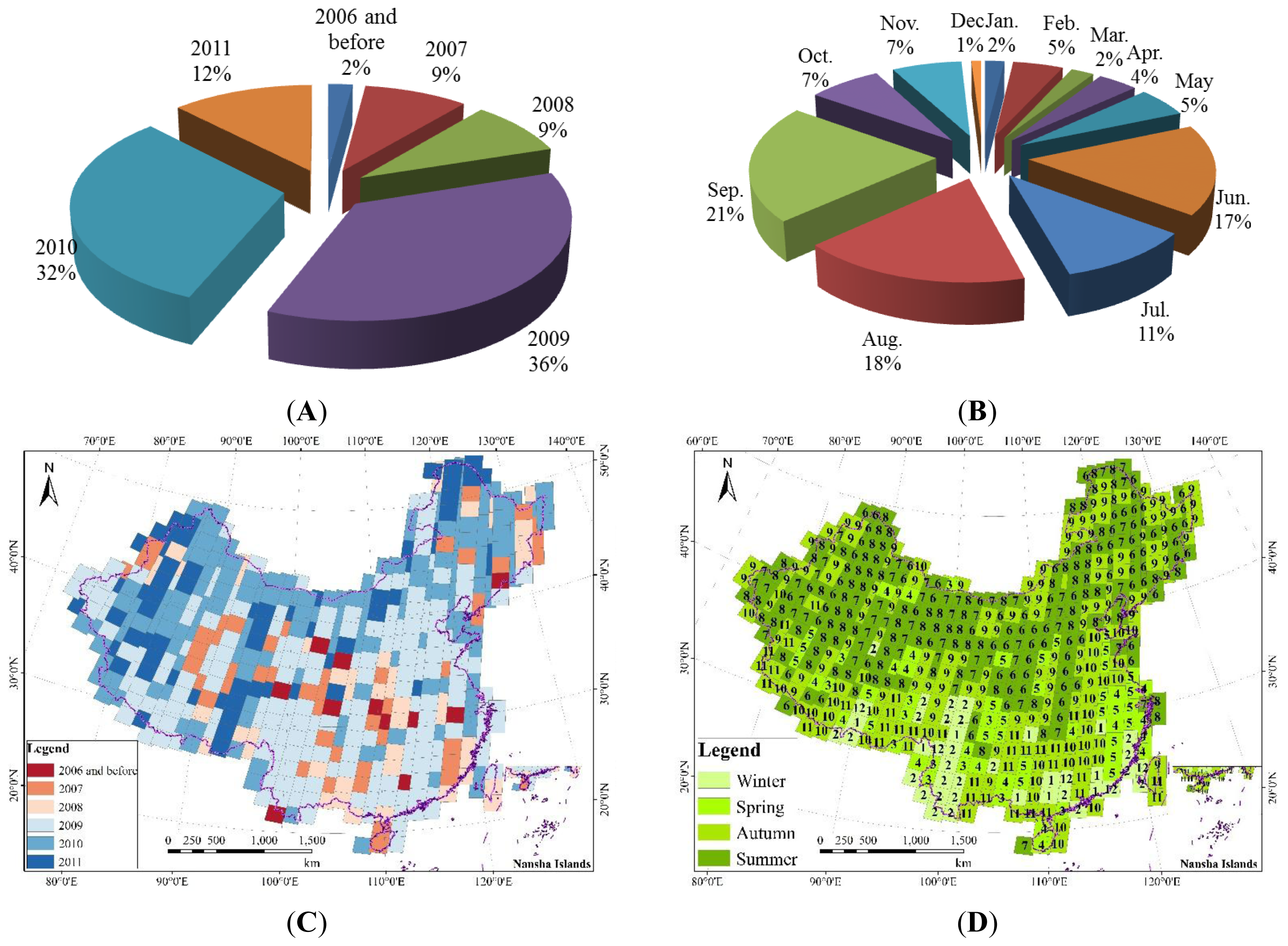
2.1. Landsat Data
2.2. MODIS
2.3. Shuttle Radar Topography Mission (SRTM) DEM
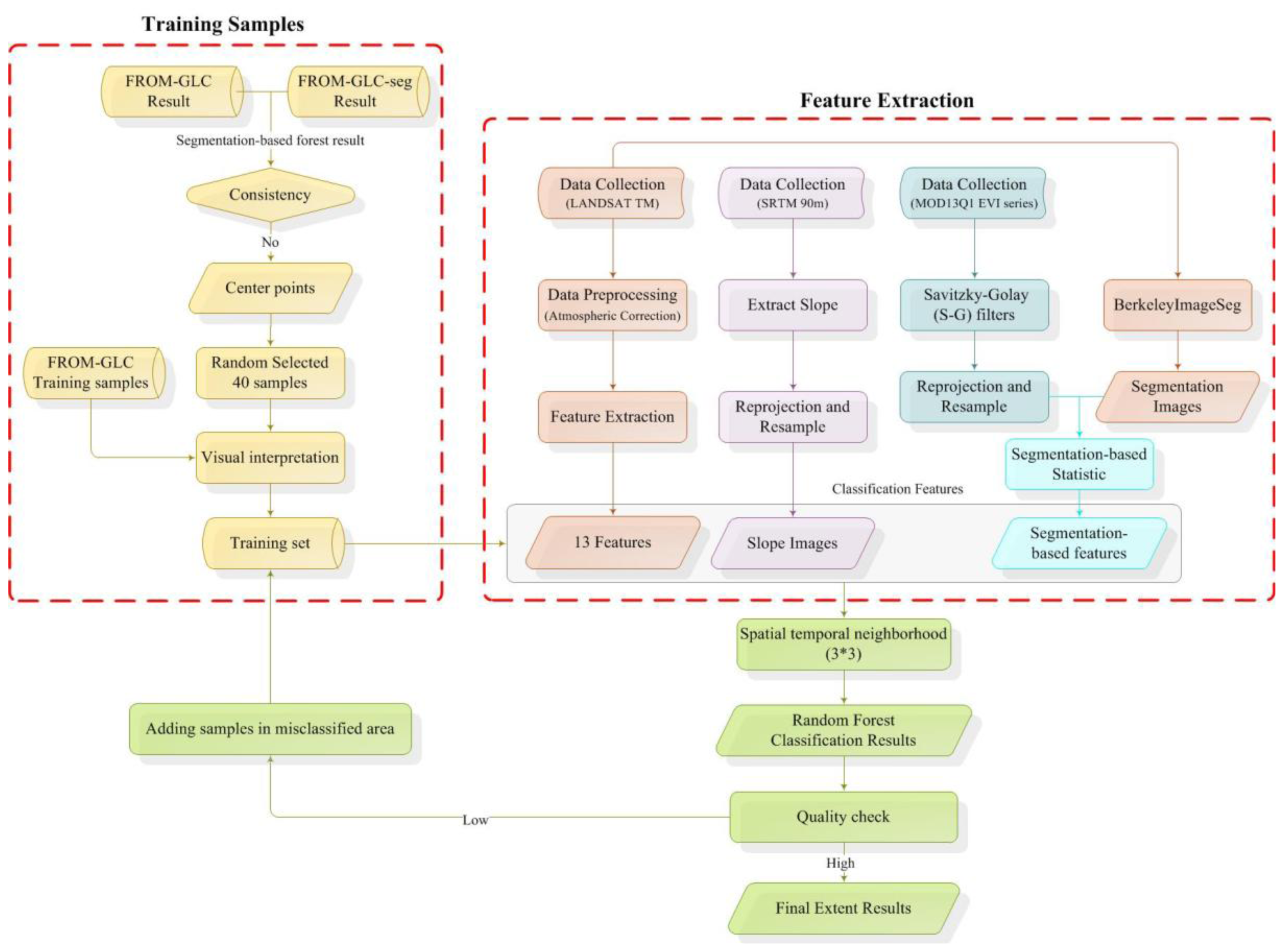
3. Methods
3.1. Forest/Non-Forest Classification
3.1.1. Feature Extraction
3.1.2. Training and Test Sample Collection
3.1.3. Forest/non-forest Classification
3.1.4. Post-Classification
3.2. Forest Type Classification
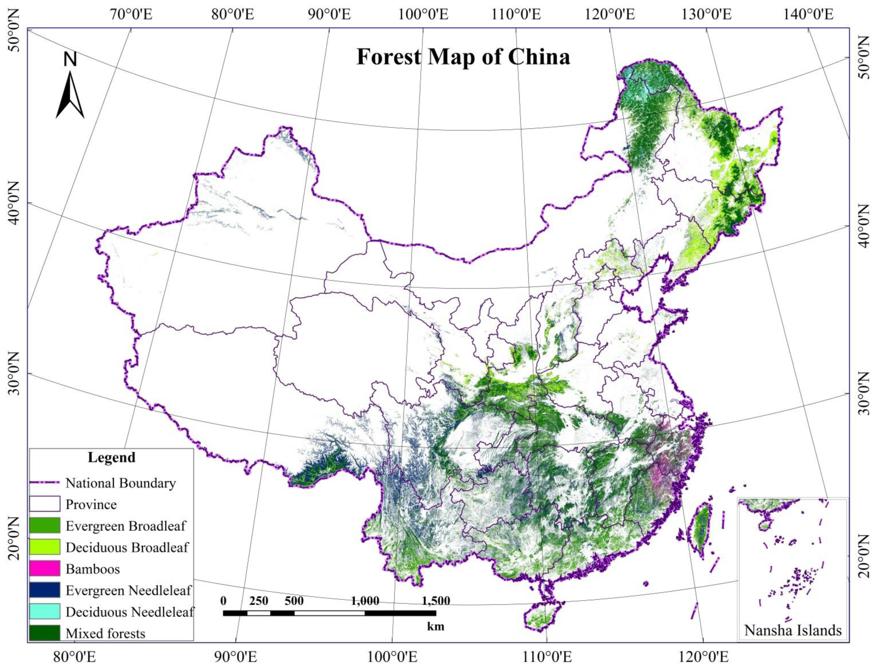
4. Results and Analysis
4.1. Results
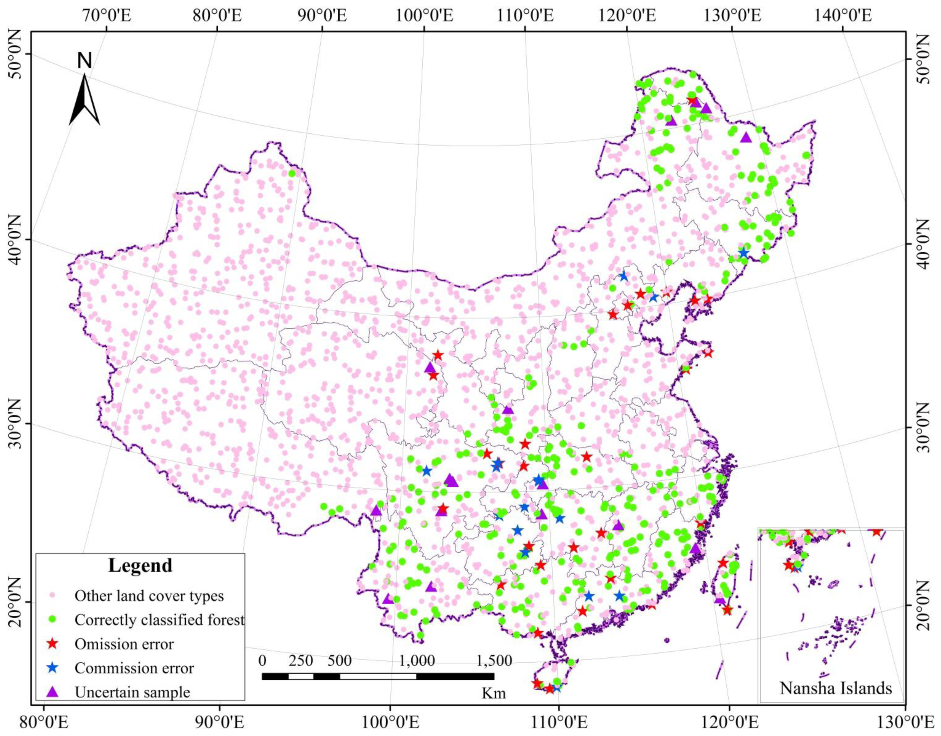
4.2. Classification Accuracy
4.2.1. Forest/Non-Forest Classification Accuracy
4.2.2. Forest Type Classification Accuracy
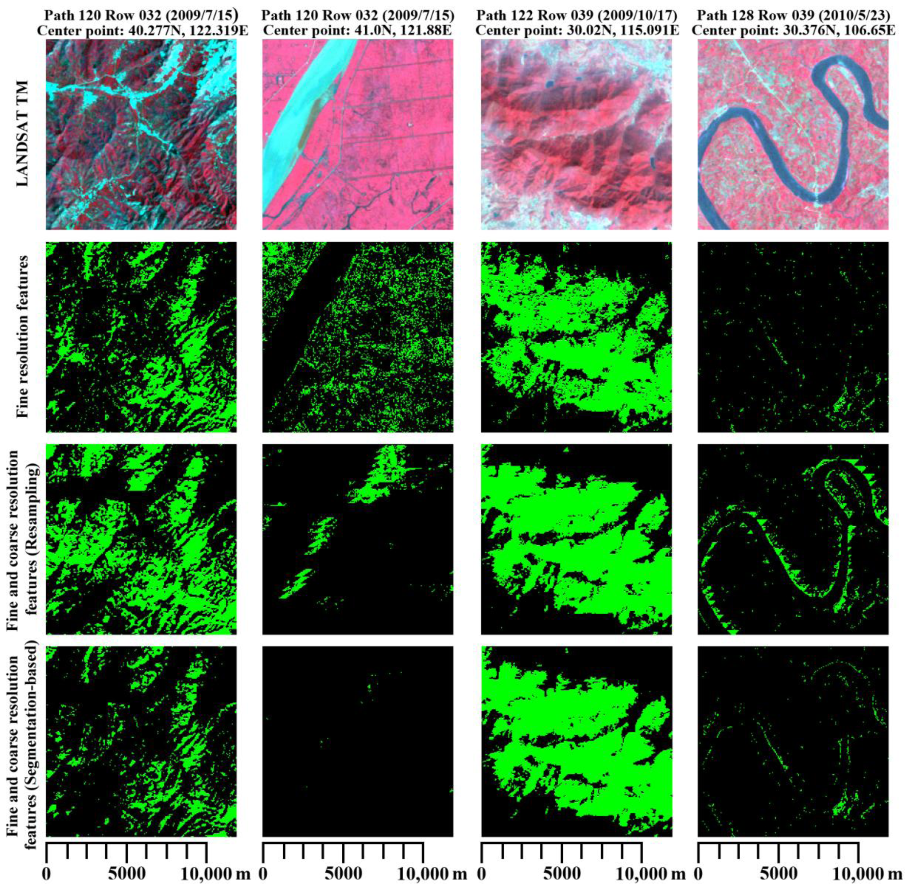
4.3. Influences of Resolution
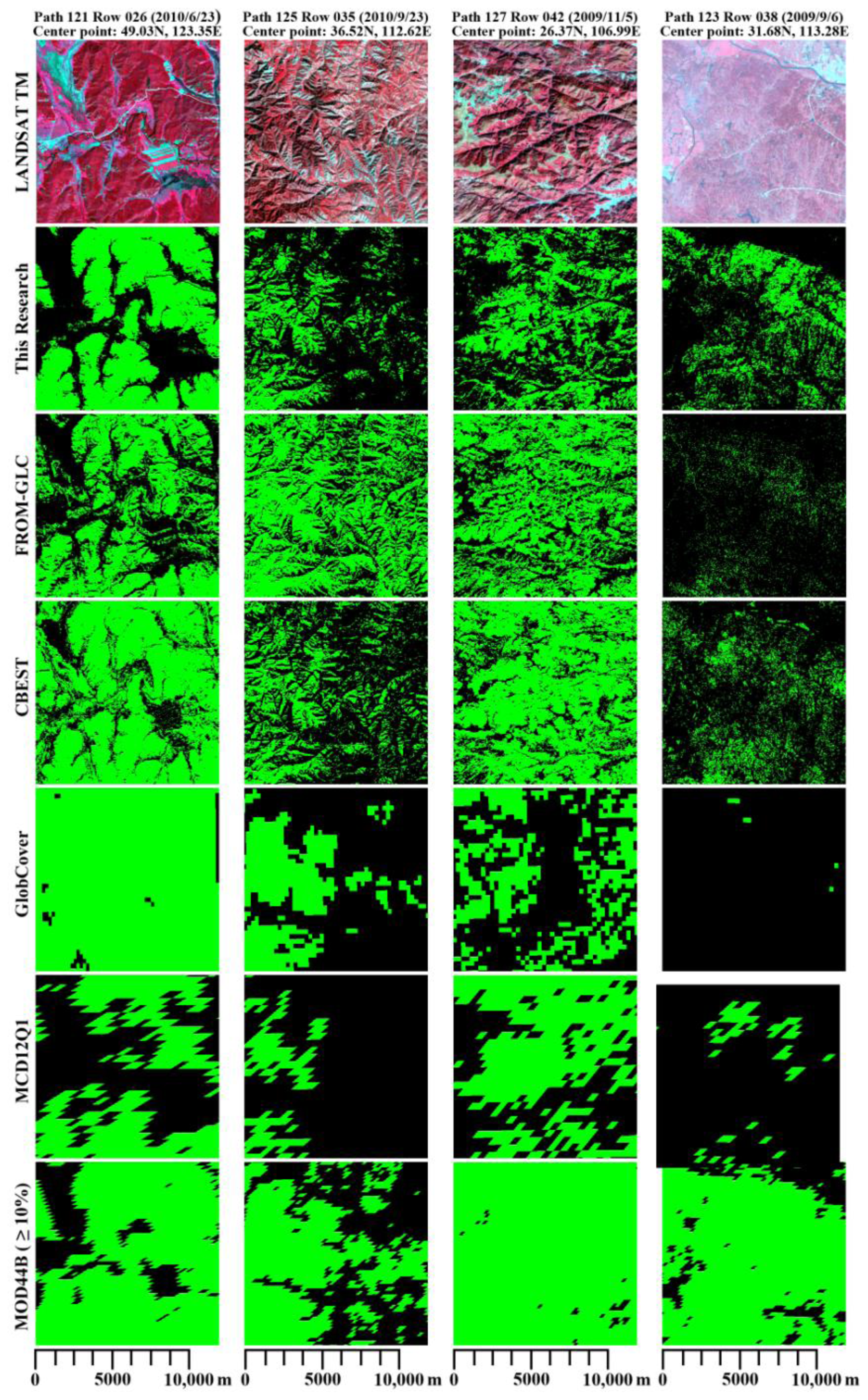
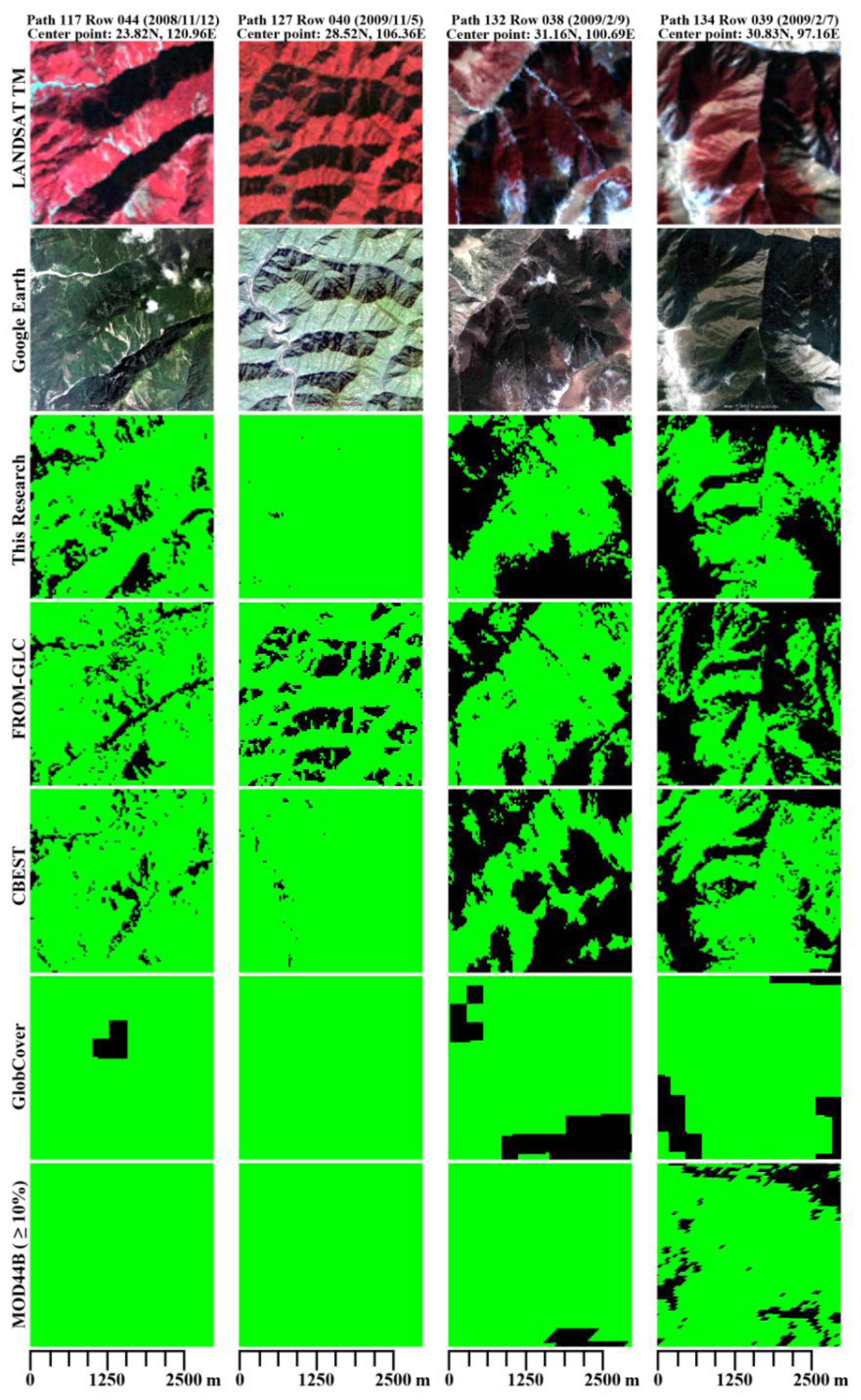
4.4. Comparison with Other Sources
5. Conclusions
Acknowledgments
Conflicts of Interest
- Author ContributionsPeng Gong and Congcong Li conceived and designed this research. Congcong Li did most of the analysis. All authors contributed extensively to data collection and writing of this paper.
References
- Food and Agriculture Organization of the United Nations, Global Forest Resources Assessment 2010; Main Report; Food and Agriculture Organization of the United Nations: Rome, Italy, 2010.
- Townshend, J.; Masek, J.G.; Huang, C.Q.; Vermote, E.F.; Gao, F.; Channan, S.; Sexton, J.O.; Feng, M.; Narasimhan, R.; Kim, D.; et al. Global characterization and monitoring of forest cover using Landsat data: Opportunities and challenges. Int. J. Digit. Earth 2012, 5, 373–397. [Google Scholar]
- Department of Forest Resources Management. The 7th national forest inventory and status of forest resources. Forest. Resour. Manag 2010, 1, 1–8. (In Chinese)
- The Central People’s Government of People’s Republic of China. Available online: http://www.gov.cn/wszb/zhibo416/ (accessed on 27 May 2014).
- Gong, P. Remote sensing of environmental changes over China: A review. Chin. Sci. Bull 2012, 57, 2793–2801. [Google Scholar]
- Liu, J.Y.; Kuang, W.H.; Zhang, X.Z.; Xu, X.L.; Qin, Y.W.; Jia, N.; Zhou, W.C.; Zhang, S.W.; Li, R.D.; Yan, C.Z.; et al. Spatiotemporal characteristics, patterns and causes of land use changes in China since the late 1980s. Acta Geogr. Sin 2014, 69, 3–14. (In Chinese) [Google Scholar]
- Zhang, Z.X. Monitoring Land Cover of China Using Remote Sensing; Planet Map Publishing House: Beijing, China, 2010. (In Chinese) [Google Scholar]
- Hu, L.; Chen, Y.; Xu, Y.; Zhao, Y.; Yu, L.; Wang, J.; Gong, P. 30 m land cover mapping of China with an efficient clustering algorithm CBEST. Sci. China Earth Sci 2014, in press. [Google Scholar]
- Bishop, C. Pattern Recognition and Machine Learning; Springer: New York, NY, USA, 2007. [Google Scholar]
- Li, C.; Wang, J.; Wang, L.; Hu, L.; Gong, P. Comparison of classification algorithms and training sample sizes in urban land classification with Landsat thematic mapper imagery. Remote Sens 2014, 6, 964–983. [Google Scholar]
- Bontemps, S.; Defourney, P.; van Bogaert, E.; Arino, O. GLOBCOVER2009 Products Description and Validation Report. Available online: http://due.esrin.esa.int/globcover/LandCover2009/GLOBCOVER2009_Validation_Report_2.2.pdf (accessed on 20 January 2012).
- Di Gregorio, A.; Jansen, L.J.M. Land Cover Classification System (LCCS). Classification Concepts and User Manual. 2000. Available online: http://www.fao.org/docrep/003/x0596e/x0596e00.HTM (accessed on 27 May 2014).
- Friedl, M.A.; Mciver, D.K.; Hodges, J.C.F.; Zhang, X.Y.; Muchoney, D.; Strahler, A.H.; Woodcock, C.E.; Gopal, S.; Schneider, A.; Cooper, A.; et al. Global land cover mapping from MODIS: Algorithms and early results. Remote Sens. Environ 2002, 83, 287–302. [Google Scholar]
- Friedl, M.A.; Sulla-Menashe, D.; Tan, B.; Schneider, A.; Ramankutty, N.; Sibley, A.; Huang, X.M. MODIS collection 5 global land cover: Algorithm refinements and characterization of new datasets. Remote Sens. Environ 2010, 114, 168–182. [Google Scholar]
- Gong, P.; Wang, J.; Yu, L.; Zhao, Y.C.; Zhao, Y.; Liang, L.; Niu, Z.G.; Huang, X.M.; Fu, H.H.; Liu, S.; et al. Finer resolution observation and monitoring of global land cover: First mapping results with Landsat TM and ETM+ data. Int. J. Remote Sens 2013, 34, 2607–2654. [Google Scholar]
- Yu, L.; Wang, J.; Gong, P. Improving 30 m global land cover map FROM-GLC with time series MODIS and auxiliary datasets: A segmentation based approach. Int. J. Remote Sens 2013, 34, 5851–5867. [Google Scholar]
- Yu, L.; Wang, J.; Li, X.C.; Li, C.C.; Zhao, Y.Y.; Gong, P. From-Hierarchy, a multi-resolution global land cover data set. Sci. China Earth Sci 2014, in press. [Google Scholar]
- Townshend, J.R.G.; Carroll, M.; Dimiceli, C.; Sohlberg, R.; Hansen, M.; DeFries, R. Vegetation Continuous Fields MOD44B, 2000–2010 Percent Tree Cover, Collection 5; University of Maryland: College Park, MD, USA, 2010. [Google Scholar]
- Hansen, M.C.; Potapov, P.V.; Moore, R.; Hancher, M.; Turubanova, S.A.; Tyukavina, A.; Thau, D.; Stehman, S.V.; Goetz, S.J.; Loveland, T.R.; et al. High-resolution global maps of 21st-century forest cover change. Science 2013, 342, 850–853. [Google Scholar]
- Food and Agriculture Organization of the United Nations (FAO). Global Forest Resources Assessment 2010: Terms and Definitions. 2010. Available online: http://www.fao.org/docrep/014/am665e/am665e00.pdf (accessed on 27 May 2014).
- Belward, A. The IGBP-DIS Global 1 km Land Cover Data Set “DISCover”: Proposal and Implementation Plans; IGBP-DIS Working Paper 13, International Geosphere Biosphere Programme; European Commission Joint Research Center: Varese, Italy, 1996. [Google Scholar]
- GLOVIS: The USGS Global Visualization Viewer. Available online: http://glovis.usgs.gov/ (accessed on 27 May 2014).
- Open Spatial Data Sharing Project RADI. Available online: http://ids.ceode.ac.cn/query.html (accessed on 27 May 2014).
- LP DAAC. Available online: https://lpdaac.usgs.gov/products/modis_products_table/mod13q1 (accessed on 14 April 2014).
- Huete, A.; Justice, C.; van Leewen, W. MODIS Vegetation Index (MODIS13) Algorithm Theoretical Basis Document Version 3. Available online: http://modis.gsfc.nasa.gov/data/atbd/atbd_mod13.pdf (access on 30 April 1999).
- Huete, A.; Didan, K.; Miura, T.; Rodriguez, E.P.; Gao, X.; Ferreira, L.G. Overview of the radiometric and biophysical performance of the MODIS vegetation indices. Remote Sens. Environ 2002, 83, 195–213. [Google Scholar]
- Miura, T.; Huete, A.R.; van Leeuwen, W.J.D.; Didan, K. Vegetation detection through smoke-filled AVIRIS images: An assessment using MODIS band passes. J. Geophys. Res 1998, 103, 32001–32011. [Google Scholar]
- CGIAR-CSI SRTM 90 m Digital Elevation Data Database. Available online: http://srtm.csi.cgiar.org/ (accessed on 19 August 2008).
- Mon, M.S.; Mizoue, N.; Htun, N.Z.; Kajisa, T.; Yoshida, S. Estimating forest canopy density of tropical mixed deciduous vegetation using Landsat data: A comparison of three classification approaches. Int. J. Remote Sens 2012, 33, 1042–1057. [Google Scholar]
- Kauth, R.J.; Thomas, G.S. The Tasseled Cap-Graphic Description of the Spectral-Temporal Development of Agricultural Crops as Seen by Landsat. Proceedings of the Symposium on Machine Processing of Remotely Sensed Data; Purdue University: West Lafayette, IN, USA, 1976; pp. 4b41–4b51. [Google Scholar]
- Crist, E.P.; Cicone, R.C. A physically-based transformation of Thematic Mapper data—The TM tasseled cap. IEEE Trans. Geosci. Remote Sens 1984, 22, 256–263. [Google Scholar]
- Chen, J.; Jönsson, P.; Tamura, M.; Gu, Z.H.; Matsushita, B.; Eklundh, L. A simple method for reconstructing a high-quality NDVI time-series dataset based on the Savitzky-Golay filter. Remote Sens. Environ 2004, 91, 332–344. [Google Scholar]
- BIS Cloud. Available online: http://www.imageseg.com (accessed on 27 May 2014).
- Clinton, N.; Holt, A.; Scarborough, J.; Yan, L.; Gong, P. Accuracy assessment measures for object based image segmentation goodness. Photogramm. Eng. Remote Sens 2010, 76, 289–299. [Google Scholar]
- Finer Resolution Observation and Monitoring—Global Land Cover. Available online: http://data.ess.tsinghua.edu.cn (accessed on 14 March 2014).
- Zhao, Y.; Yu, L.; Hu, L.Y.; Li, X.Y.; Li, C.; Zhang, H.Y.; Zheng, Y.M.; Zhao, Y.C.; Cheng, Q.; Liu, C.X.; et al. Towards a common validation sample set for global land cover mapping. Int. J. Remote Sens 2014, in press. [Google Scholar]
- Breiman, L. Random forests. Mach. Learn 2001, 45, 5–32. [Google Scholar]
- Landsat Bulk Metadata Service. Available online: http://Landsat.usgs.gov/consumer.php (accessed on 27 May 2014).
- China’s State Forestry Administration. China Forest Resources Report—The 7th National Forest Resource Inventory. Available online: http://wenku.baidu.com/link?url=yCgzhDhX0OFdntS4s-SMeyQwWYzaneh10tnU9br0pIVQCsakGH6Ogqey-uCdlrjMF6Z5TOO1FX3cO5oo300Gmf5QZd1pTdgK44BVaAcBMz3 (accessed on 27 May 2014).
- The Central People’s Government of People’s Republic of China. Available online: http://www.gov.cn/zxft/ft205/content_1695019.htm (accessed on 27 May 2014).
- Tibshirani, R. Bias, Variance, and Prediction Error for Classification Rules; Technical Report; University of Toronto: Toronto, ON, Canada, 1996. [Google Scholar]
- Huang, H.; Gong, P.; Clinton, N.; Hui, F. Reduction of atmospheric and topographic effect on Landsat TM data for forest classification. Int. J. Remote Sens 2008, 29, 5623–5642. [Google Scholar]
- Waske, B.; van der Linden, S. Classifying multilevel imagery from SAR and optical sensors by decision fusion. IEEE Trans. Geosci. Remote Sens 2008, 46, 1457–1466. [Google Scholar]


| Feature | Formula or Algorithm |
|---|---|
| Spectral features | Surface reflectance Band 1–Band 5, Band 7 |
| Temperature | Calibrated from thermal infrared band |
| Enhanced Vegetation Index (EVI) | |
| Shadow Index (SI) | ((10000 − BLUE) × (10000 − GREEN) × (10000 − RED))1/3 |
| Bare soil Index (BI) | |
| Greenness | −0.2848 (Band 1) − 0.2435 (Band 2) − 0.5436 (Band 3) + 0.7243 (Band 4) + 0.0840 (Band 5) − 0.1800 (Band 7) |
| Wetness | 0.1509 (Band 1) + 0.1973 (Band 2) + 0.3279 (Band 3) + 0.3406 (Band 4) − 0.7112 (Band 5) − 0.4572 (Band 7) |
| Brightness | 0.3037 (Band 1) + 0.2793 (Band 2) + 0.4743 (Band 3) + 0.5585 (Band 4) + 0.5082 (Band 5) + 0.1863 (Band 7) |
| Slope | Calculated from SRTM |
| Mean Winter EVI | Averaged EVI values of December, January and February |
| EVI time series | All the EVI values except those in winter |
| Province | Forest Area (10,000 ha) | Forest Coverage Rate | Province | Forest Area (10,000 ha) | Forest Coverage Rate |
|---|---|---|---|---|---|
| Anhui | 322.691 | 23.00% | Liaoning | 313.901 | 21.57% |
| Macao | 0.028 | 12.47% | Inner Mongolia | 1338.422 | 11.67% |
| Beijing | 25.334 | 15.46% | Ningxia | 5.194 | 1.00% |
| Fujian | 674.005 | 55.40% | Qinghai | 23.512 | 0.33% |
| Gansu | 276.577 | 6.82% | Shandong | 52.075 | 3.39% |
| Guangdong | 646.289 | 36.56% | Shanxi | 248.106 | 15.86% |
| Guangxi | 909.395 | 38.49% | Shaanxi | 766.779 | 37.24% |
| Guizhou | 593.855 | 33.75% | Shanghai | 0.055 | 0.09% |
| Hainan | 80.465 | 23.80% | Sichuan | 1347.007 | 27.84% |
| Hebei | 176.739 | 9.44% | Taiwan | 210.065 | 58.25% |
| Henan | 219.540 | 13.26% | Tianjin | 1.380 | 1.19% |
| Heilongjiang | 1822.689 | 40.27% | Tibet | 790.407 | 6.57% |
| Hubei | 714.795 | 38.43% | Hong Kong | 4.929 | 46.45% |
| Hunan | 938.114 | 44.24% | Xinjiang | 157.376 | 0.96% |
| Jilin | 735.188 | 38.52% | Yunnan | 1450.589 | 37.85% |
| Jiangsu | 37.491 | 3.71% | Zhejiang | 514.054 | 50.44% |
| Jiangxi | 797.623 | 47.75% | Chongqing | 295.540 | 35.84% |
| Total | 16,490.208 | 17.38% |
| Errors | Main Causes | Number of Samples |
|---|---|---|
| Omission Errors | Mixed pixels | 4 |
| The edge of land cover type | 17 | |
| Shadow of mountains | 2 | |
| Shadow of clouds or contaminated by clouds | 3 | |
| Pepper and Salt | 1 | |
| Others | 4 | |
| Commission Errors | Mixed pixels | 1 |
| The edge of land cover type | 8 | |
| Shadow of clouds or contaminated by clouds | 1 | |
| Others | 6 | |
| Ground Truth | |||||||
|---|---|---|---|---|---|---|---|
| Evergreen Broadleaf | Deciduous Broadleaf | Evergreen Needleleaf | Deciduous Needleleaf | Mixed Forests | Bamboos | Total | |
| Evergreen Broadleaf | 166 | 0 | 7 | 0 | 31 | 7 | 211 |
| Deciduous Broadleaf | 0 | 273 | 7 | 2 | 90 | 0 | 372 |
| Evergreen Needleleaf | 7 | 5 | 478 | 14 | 66 | 8 | 578 |
| Deciduous Needleleaf | 0 | 1 | 9 | 50 | 10 | 0 | 70 |
| Mixed forests | 30 | 111 | 78 | 29 | 437 | 16 | 701 |
| Bamboos | 3 | 0 | 1 | 0 | 5 | 28 | 37 |
| Total | 206 | 390 | 580 | 95 | 639 | 59 | 1969 |
| Overall Accuracy: 72.73% | |||||||
© 2014 by the authors; licensee MDPI, Basel, Switzerland This article is an open access article distributed under the terms and conditions of the Creative Commons Attribution license (http://creativecommons.org/licenses/by/3.0/).
Share and Cite
Li, C.; Wang, J.; Hu, L.; Yu, L.; Clinton, N.; Huang, H.; Yang, J.; Gong, P. A Circa 2010 Thirty Meter Resolution Forest Map for China. Remote Sens. 2014, 6, 5325-5343. https://doi.org/10.3390/rs6065325
Li C, Wang J, Hu L, Yu L, Clinton N, Huang H, Yang J, Gong P. A Circa 2010 Thirty Meter Resolution Forest Map for China. Remote Sensing. 2014; 6(6):5325-5343. https://doi.org/10.3390/rs6065325
Chicago/Turabian StyleLi, Congcong, Jie Wang, Luanyun Hu, Le Yu, Nicholas Clinton, Huabing Huang, Jun Yang, and Peng Gong. 2014. "A Circa 2010 Thirty Meter Resolution Forest Map for China" Remote Sensing 6, no. 6: 5325-5343. https://doi.org/10.3390/rs6065325