An Airborne Multispectral Imaging System Based on Two Consumer-Grade Cameras for Agricultural Remote Sensing

Abstract
:1. Introduction
2. System Design and Description
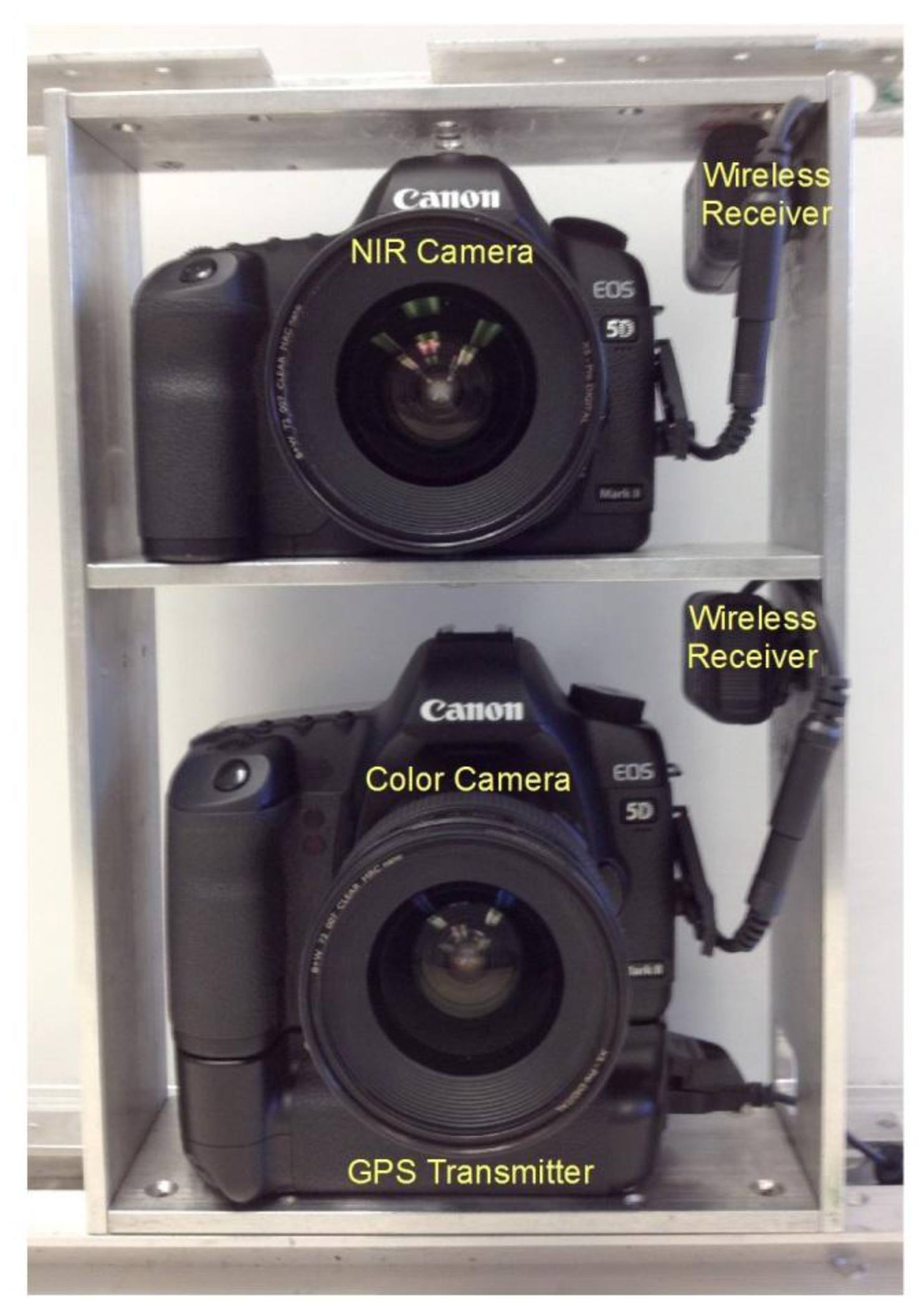
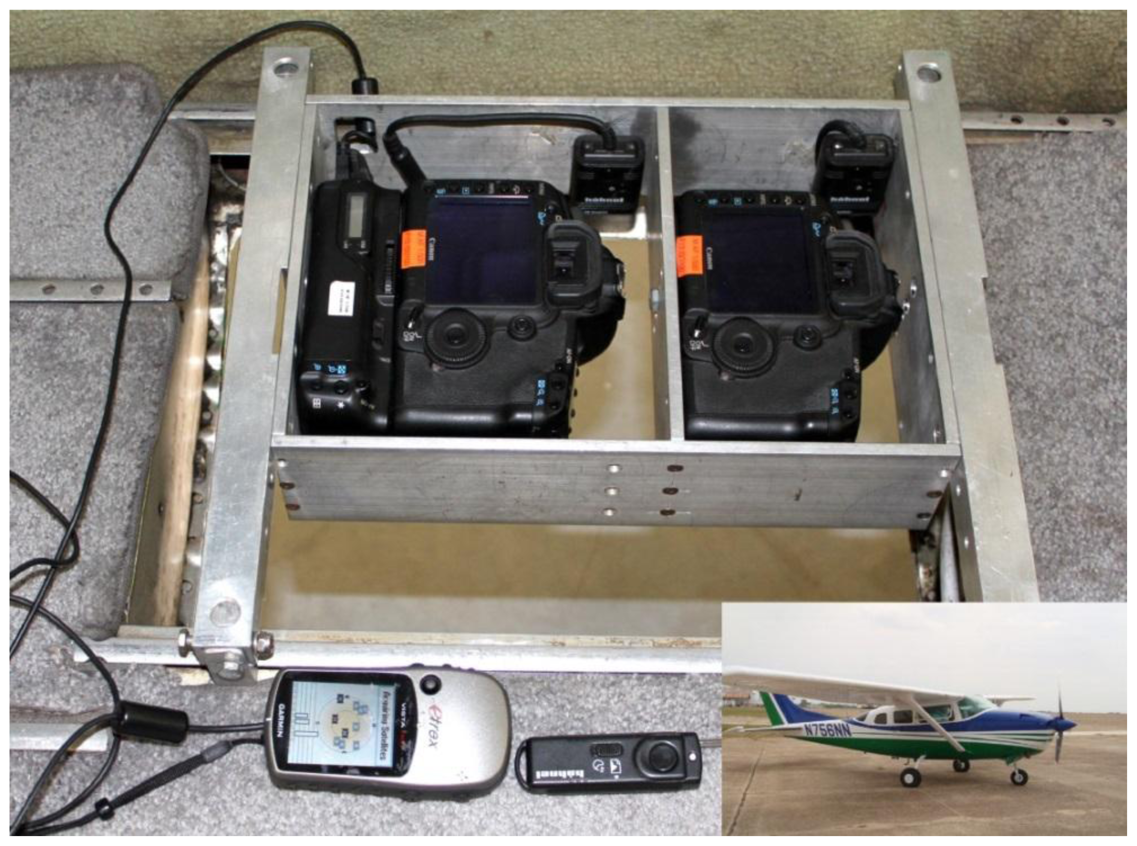
2.1. Selection and Configuration of System Components
2.2. Parameter Settings of Cameras
2.3. Image Alignment
2.4. Ground Coverage and Pixel Size
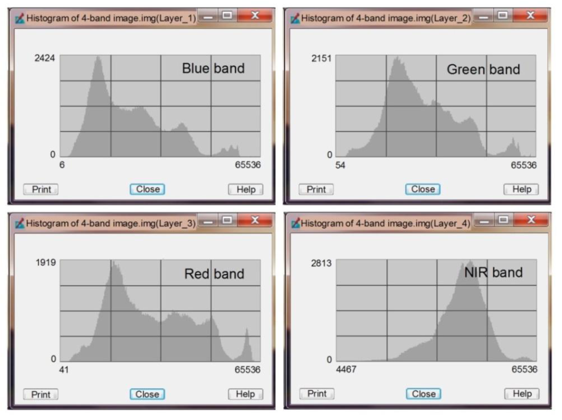
3. Image Acquisition, Visualization and Preprocessing
4. Application Examples
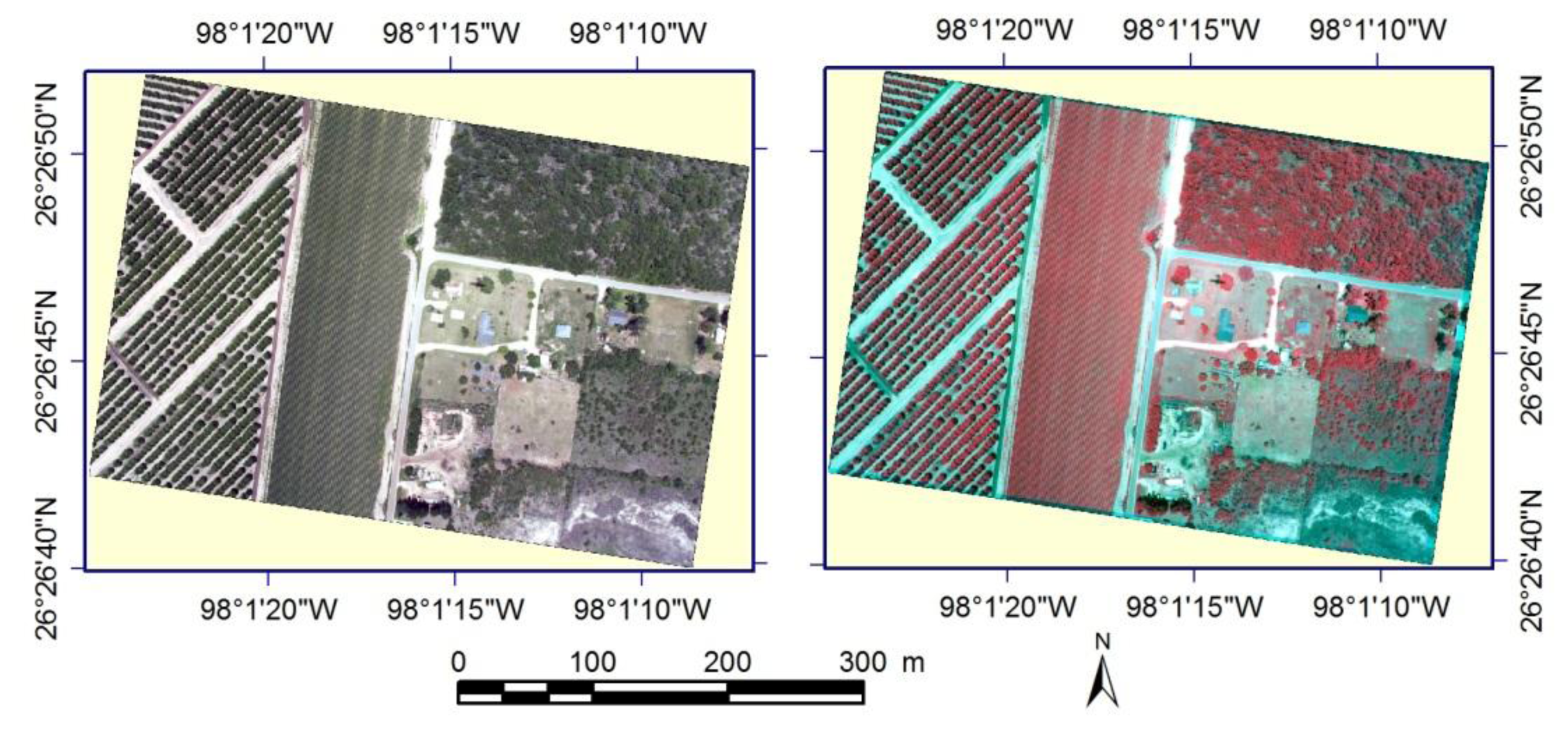
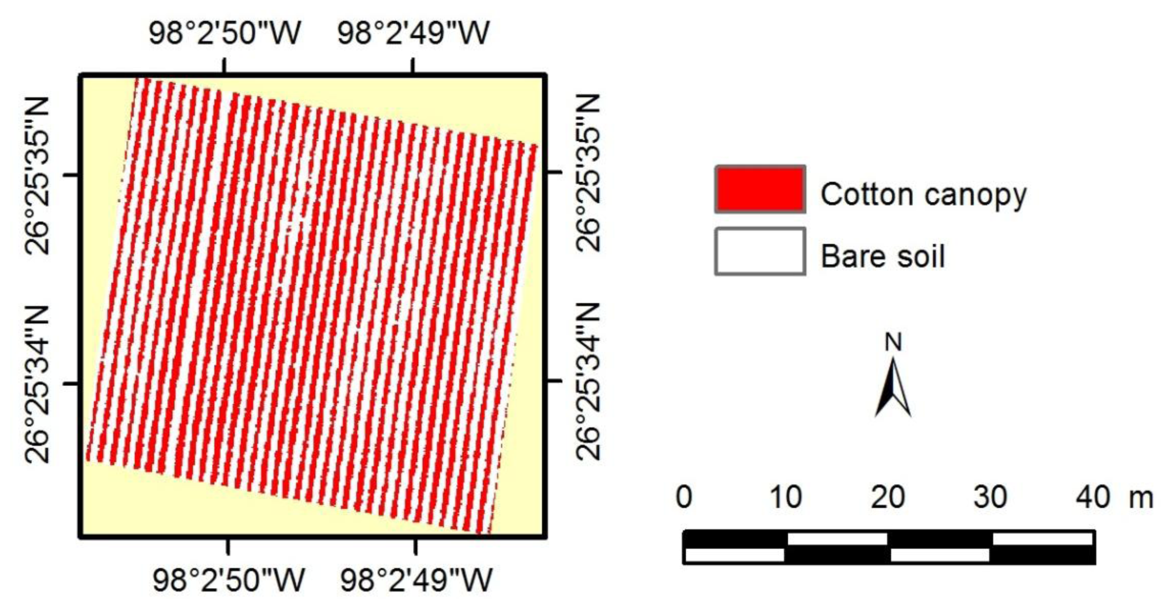
4.1. Estimating Cotton Canopy Cover
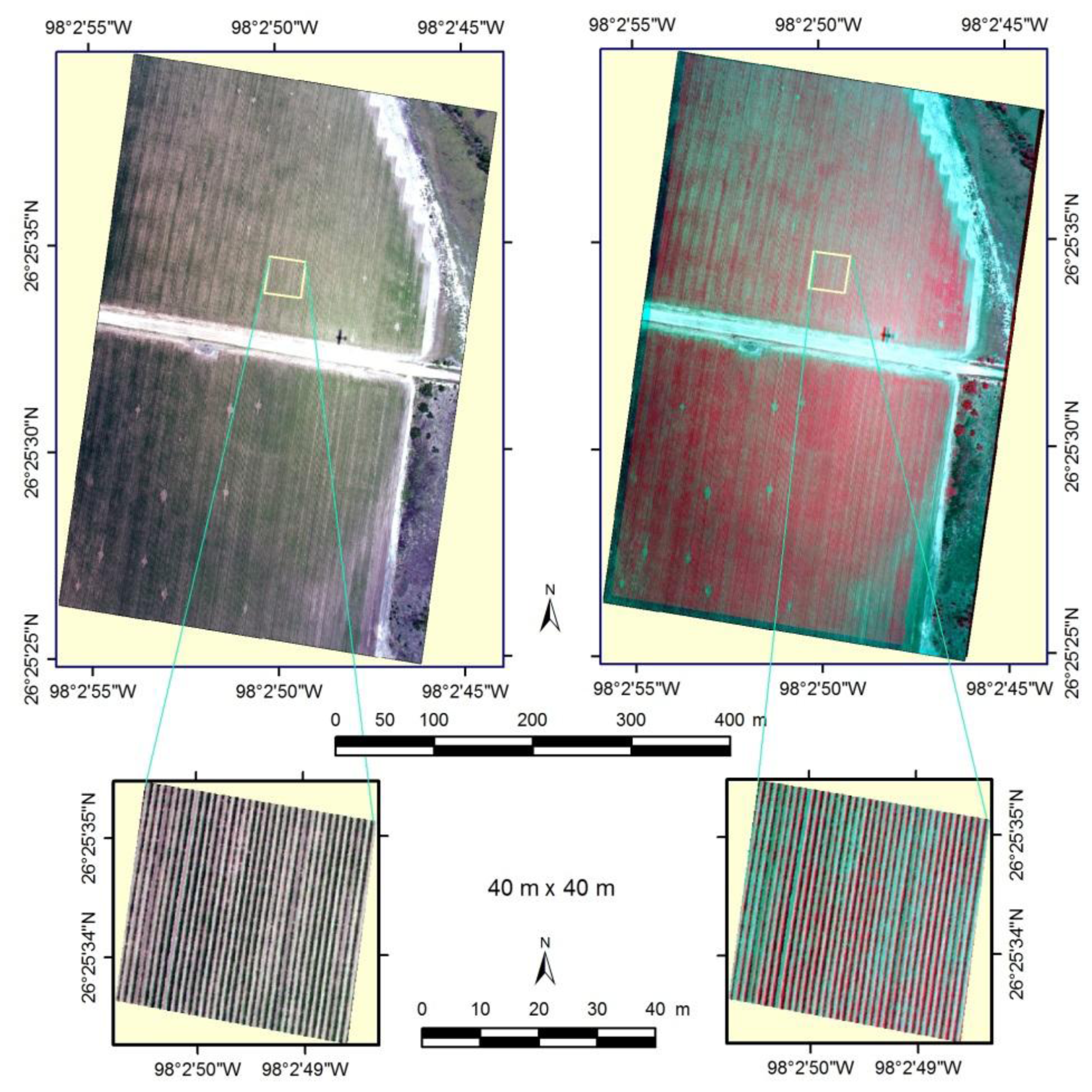
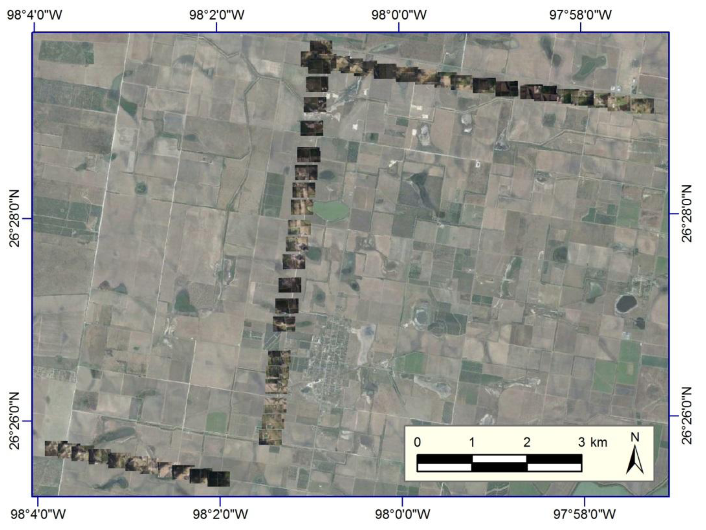
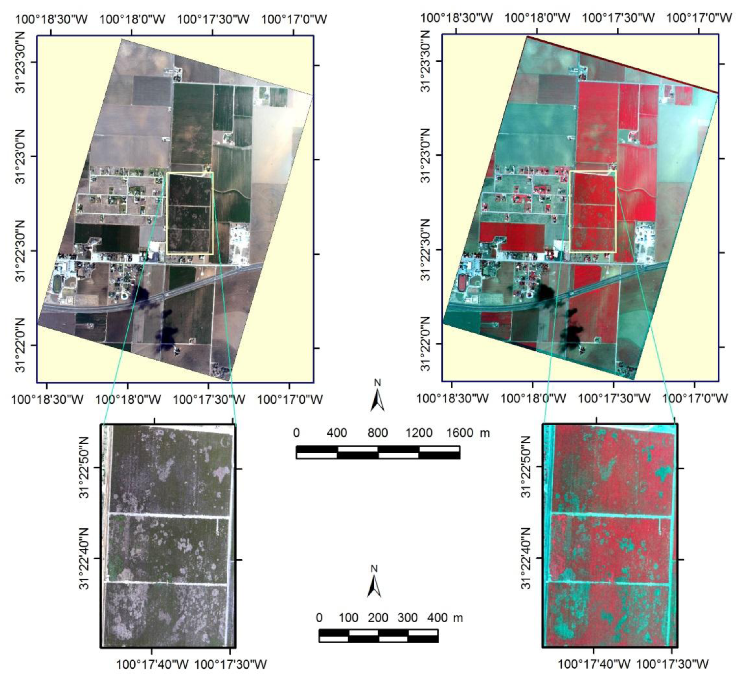
4.2. Mapping Cotton Root Rot
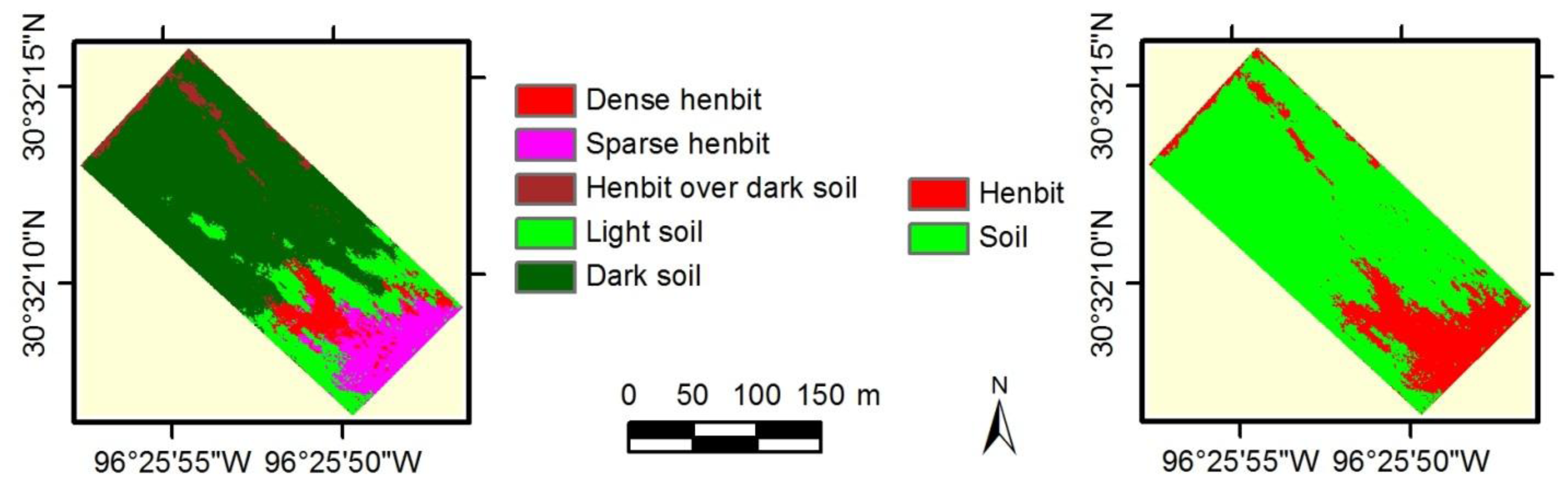
4.3. Mapping Henbit
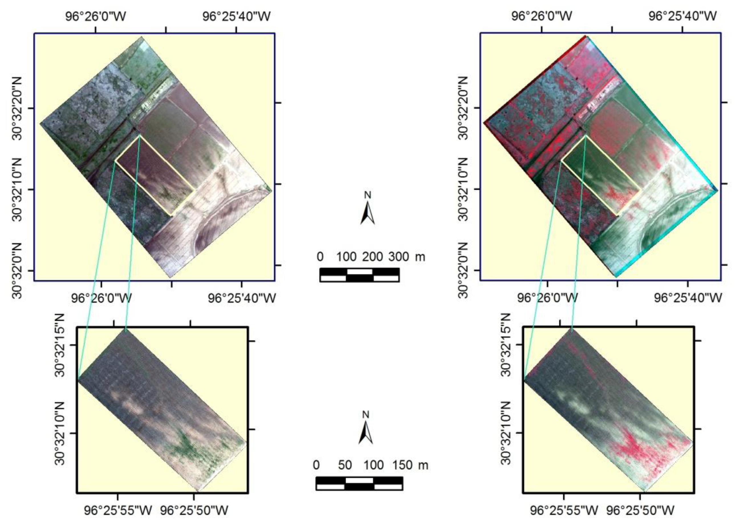
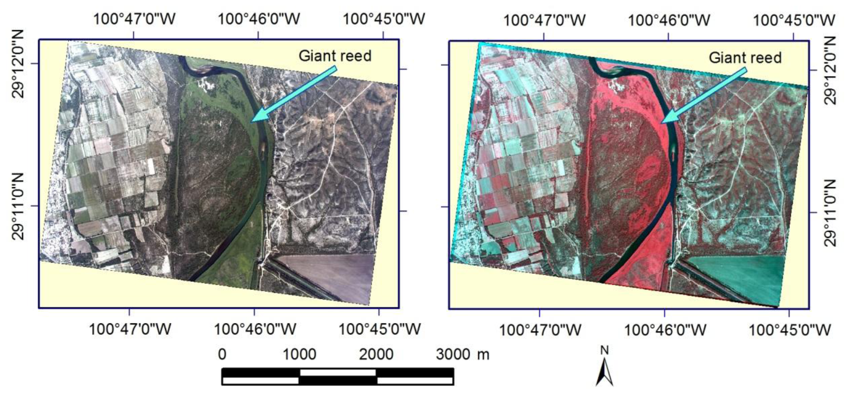
4.4. Mapping Giant Reed
5. Error and Uncertainty Analysis of the Imaging System
6. Conclusions
Acknowledgments
Conflicts of Interest
- Author ContributionsChenghai Yang designed, assembled, tested and evaluated the imaging system, analyzed the sample images and wrote the manuscript. The coauthors participated in the evaluation of the system for different applications. John Westbrook and Charles Suh were involved in the evaluation of the system for estimating cotton canopy cover. Daniel Martin, Clint Hoffmann, Yubin Lan and Bradley Fritz were involved in the evaluation of the system for mapping henbit infestations for aerial application. John Goolsby was involved in the evaluation of the system for mapping giant reed infestations.
- DisclaimerMention of trade names or commercial products in this publication is solely for the purpose of providing specific information and does not imply recommendation or endorsement by the U.S. Department of Agriculture.
References
- Everitt, J.H.; Escobar, D.E.; Alaniz, M.A.; Davis, M.R. Using multispectral video imagery for detecting soil surface conditions. Photogramm. Eng. Remote Sens 1989, 55, 467–471. [Google Scholar]
- Mausel, P.W.; Everitt, J.H.; Escobar, D.E.; King, D.J. Airborne videography: Current status and future perspectives. Photogramm. Eng. Remote Sens 1992, 58, 1189–1195. [Google Scholar]
- Pearson, R.; Mao, C.; Grace, J. Real-time airborne agricultural monitoring. Remote Sens. Environ 1994, 49, 304–310. [Google Scholar]
- Pinter, P.J., Jr.; Hatfield, J.L.; Schepers, J.S.; Barnes, E.M.; Moran, M.S.; Daughtry, C.S.T.; Upchurch, D.R. Remote sensing for crop management. Photogramm. Eng. Remote Sens 2003, 69, 647–664. [Google Scholar]
- Backoulou, G.F.; Elliott, N.C.; Giles, K.; Phoofolo, M.; Catana, V. Development of a method using multispectral imagery and spatial pattern metrics to quantify stress to wheat fields caused by. Diuraphis noxia. Comput. Electron. Agric 2011, 75, 64–70. [Google Scholar]
- Escobar, D.E.; Everitt, J.H.; Noriega, J.R.; Cavazos, I.; Davis, M.R. A twelve-band airborne digital video imaging system (ADVIS). Remote Sens. Environ 1998, 66, 122–128. [Google Scholar]
- Gorsevski, P.V.; Gessler, P.E. The design and the development of a hyperspectral and multispectral airborne mapping system. ISPRS J. Photogramm. Remote Sens 2009, 64, 184–192. [Google Scholar]
- Yang, C. A high resolution airborne four-camera imaging system for agricultural applications. Comput. Electron. Agric 2012, 88, 13–24. [Google Scholar]
- Bausch, W.C.; Khosla, R. QuickBird satellite versus ground-based multi-spectral data for estimating nitrogen status of irrigated maize. Precis. Agric 2010, 11, 274–290. [Google Scholar]
- McCarthy, M.J.; Halls, J.N. Habitat mapping and change assessment of coastal environments: An examination of WorldView-2, QuickBird, and IKONOS satellite imagery and airborne LiDAR for mapping barrier island habitats. ISPRS Int. J. Geo-Inf 2014, 3, 297–325. [Google Scholar]
- Hunt, E.R., Jr.; Hively, W.D.; Fujikawa, S.J.; Linden, D.S.; Daughtry, C.S.T.; McCarty, G.W. Acquisition of NIR-green-blue digital photographs from unmanned aircraft for crop monitoring. Remote Sens 2010, 2, 290–305. [Google Scholar]
- Laliberte, A.S.; Goforth, M.A.; Steele, C.M.; Rango, A. Multispectral remote sensing from unmanned aircraft: Image processing workflows and applications for rangeland environments. Remote Sens 2011, 3, 2529–2551. [Google Scholar]
- Watts, A.C.; Ambrosia, V.G.; Hinkley, E.A. Unmanned aircraft systems in remote sensing and scientific research: Classification and considerations of use. Remote Sens 2012, 4, 1671–1692. [Google Scholar]
- Bayer, B.E. Color Imaging Array. US Patent 3971065, 20.
- Hirakawa, K.; Wolfe, P.J. Spatio-Spectral Sampling and Color Filter Array Design. In Single-Sensor Imaging: Methods and Applications for Digital Cameras; Lukac, R., Ed.; CRC Press: Boca Raton, FL, USA, 2008; pp. 137–151. [Google Scholar]
- Levin, N.; Ben-Dor, E.; Singer, A. A digital camera as a tool to measure colour indices and related properties of sandy soils in semi-arid environments. Int. J. Remote Sens 2005, 26, 5475–5492. [Google Scholar]
- Lebourgeois, V.; Bégué, A.; Labbé, S.; Mallavan, B.; Prévot, L.; Roux, B. Can commercial digital cameras be used as multispectral sensors?—A crop monitoring test. Sensors 2008, 8, 7300–7322. [Google Scholar]
- Hardin, P.J.; Jensen, R.R. Small-scale unmanned aerial vehicles in environmental remote sensing: Challenges and opportunities. GISci. Remote Sens 2011, 48, 99–111. [Google Scholar]
- Sakamoto, T.; Gitelson, A.A.; Nguy-Robertson, A.L.; Arkebauer, T.J.; Wardlow, B.D.; Suyker, A.E.; Verma, S.B. An alternative method using digital cameras for continuous monitoring of crop status. Agric. For. Meteorol 2012, 154–155, 113–126. [Google Scholar]
- Nijland, W.; de Jong, R.; de Jong, S.M.; Wulder, M.A.; Bater, C.W.; Coops, N.C. Monitoring plant condition and phenology using infrared sensitive consumer grade digital cameras. Agric. For. Meteorol 2014, 184, 98–106. [Google Scholar]
- Rabatel, G.; Gorretta, N.; Labbé, N. Getting simultaneous red and near-infrared band data from a single digital camera for plant monitoring applications: Theoretical and practical study. Biosyst. Eng 2014, 117, 2–14. [Google Scholar] [Green Version]
- Yang, C.; Everitt, J.H.; Bradford, J.M. Airborne hyperspectral imagery and yield monitor data for estimating grain sorghum yield variability. Trans. ASAE 2004, 47, 915–924. [Google Scholar]
- Yang, C.; Everitt, J.H.; Bradford, J.M. Airborne hyperspectral imagery and linear spectral unmixing for mapping variation in crop yield. Precis. Agric 2007, 8, 279–296. [Google Scholar]
- Yang, C.; Goolsby, J.A.; Everitt, J.H.; Du, Q. Applying six classifiers to airborne hyperspectral imagery for detecting giant reed. Geocarto Int 2012, 27, 413–424. [Google Scholar]
- Kumar, A.; Lee, W.S.; Ehsani, M.R.; Albrigo, L.G.; Yang, C.; Mangan, R.L. Citrus greening disease detection using aerial hyperspectral and multispectral imaging techniques. J. Appl. Remote Sens 2012, 6, 063542. [Google Scholar]
- Akkaynak, D.; Treibitz, T.; Xiao, B.; Gürkan, U.A.; Allen, J.J.; Demirci, U.; Hanlon, R.T. Use of commercial off-the-shelf digital cameras for scientific data acquisition and scene-specific color calibration. J. Opt. Soc. Am 2014, 31, 312–321. [Google Scholar]
- Intergraph Corporation, ERDAS Field Guide; Intergraph Corporation: Huntsville, AL, USA, 2013.
- Yang, C.; Odvody, G.N.; Fernandez, C.J.; Landivar, J.A.; Minzenmayer, R.R.; Nichols, R.L.; Thomasson, J.A. Monitoring cotton root rot progression within a growing season using airborne multispectral imagery. J. Cotton Sci 2014, 18, 85–93. [Google Scholar]
- Richards, J.A. Remote Sensing Digital Image Analysis; Springer-Verlag: Berlin, Germany, 1999. [Google Scholar]
- Yang, C.; Everitt, J.H.; Goolsby, J.A. Using aerial photography for mapping giant reed infestations along the Texas-Mexico portion of the Rio Grande. Invasive Plant Sci. Manag 2011, 4, 402–410. [Google Scholar]


| Characteristics | Description |
|---|---|
| Camera type | Digital, single-lens reflex |
| Sensor type | CMOS |
| Sensing area | 36 × 24 mm |
| Pixel array | 2784 × 1856, 3861 × 2574 or 5616 × 3744 |
| Image type | RAW (14-bit) + JPEG |
| Image size | 10.8 + 2.1 MB, 14.8 + 3.6 MB or 25.8 + 6.1 MB |
| Shooting speed | Max 3.9 shots/s |
| Display | 3-in TFT color LCD |
| Recording media | Type I or II CF card |
| ISO speed | 100–6400 |
| Shutter speed | 1/8000 to 30 s |
| Dimensions | 152 × 113.5 × 75 mm |
| Weight | 810 g |
| Operating temperature | 0–40 °C |
| Flight Height | Ground Coverage | Pixel Size * | |||
|---|---|---|---|---|---|
| (m) | (ft) | (m × m) | (ft × ft) | (m) | (ft) |
| 305 | 1000 | 549 × 366 | 1800 × 1200 | 0.10 | 0.32 |
| 610 | 2000 | 1097 × 732 | 3600 × 2400 | 0.20 | 0.64 |
| 914 | 3000 | 1646 × 1097 | 5400 × 3600 | 0.29 | 0.96 |
| 1219 | 4000 | 2195 × 1463 | 7200 × 4800 | 0.39 | 1.28 |
| 1524 | 5000 | 2743 × 1829 | 9000 × 6000 | 0.49 | 1.60 |
| 1829 | 6000 | 3292 × 2195 | 10,800 × 7200 | 0.59 | 1.92 |
| 2134 | 7000 | 3840 × 2560 | 12,600 × 8400 | 0.68 | 2.24 |
| 2438 | 8000 | 4389 × 2926 | 14,400 × 9600 | 0.78 | 2.56 |
| 2743 | 9000 | 4938 × 3292 | 16,200 × 10,800 | 0.88 | 2.88 |
| 3048 | 10,000 | 5486 × 3658 | 18,000 × 12,000 | 0.98 | 3.21 |
| Flight Height AGL | No. of Points | First-Order Transformation | Second-Order Transformation | ||||
|---|---|---|---|---|---|---|---|
| x | y | Total | x | y | Total | ||
| 305 m (1000 ft) | 4 | 4.6 | 2.3 | 5.1 | |||
| 5 | 5.3 | 2.5 | 5.9 | ||||
| 6 | 4.9 | 2.5 | 5.5 | ||||
| 7 | 4.9 | 2.4 | 5.4 | 0.3 | 0.2 | 0.4 | |
| 8 | 4.6 | 2.3 | 5.1 | 0.5 | 0.4 | 0.6 | |
| 9 | 4.4 | 2.2 | 4.9 | 0.5 | 0.4 | 0.6 | |
| 10 | 4.2 | 2.1 | 4.7 | 0.5 | 0.4 | 0.6 | |
| 610 m (2000 ft) | 4 | 3.9 | 6.5 | 7.6 | |||
| 5 | 5.3 | 6.0 | 7.9 | ||||
| 6 | 4.9 | 6.0 | 7.8 | ||||
| 7 | 4.6 | 5.6 | 7.2 | 0.1 | 0.4 | 0.4 | |
| 8 | 5.9 | 5.2 | 7.9 | 0.3 | 0.4 | 0.5 | |
| 9 | 5.7 | 5.1 | 7.6 | 0.5 | 0.4 | 0.7 | |
| 10 | 5.6 | 4.8 | 7.4 | 0.5 | 0.4 | 0.7 | |
| 1219 m (4000 ft) | 4 | 5.8 | 3.1 | 6.6 | |||
| 5 | 5.6 | 2.9 | 6.3 | ||||
| 6 | 5.2 | 2.8 | 5.9 | ||||
| 7 | 4.9 | 2.8 | 5.6 | 0.3 | 0.4 | 0.5 | |
| 8 | 4.6 | 2.7 | 5.4 | 0.5 | 0.4 | 0.6 | |
| 9 | 4.6 | 2.8 | 5.4 | 0.5 | 0.3 | 0.6 | |
| 10 | 4.4 | 2.7 | 5.1 | 0.5 | 0.4 | 0.6 | |
| Application Example | Longitude | Latitude | Flight Height | First-Order | Second-Order | |||||
|---|---|---|---|---|---|---|---|---|---|---|
| Degree | Degree | m | ft | x | y | Total | x | y | Total | |
| Estimating cotton width | −98.0474 | 26.4257 | 305 | 1000 | 5.5 | 3.0 | 6.3 | 0.3 | 0.5 | 0.6 |
| Mapping root rot | −100.2948 | 31.3793 | 1524 | 5000 | 3.8 | 3.0 | 4.9 | 0.2 | 0.3 | 0.4 |
| Mapping henbit | −96.4317 | 30.5369 | 457 | 1500 | 4.9 | 4.5 | 6.7 | 0.3 | 0.4 | 0.5 |
| Mapping giant reed | −100.7716 | 29.1869 | 2438 | 8000 | 3.0 | 3.1 | 4.3 | 0.3 | 0.4 | 0.5 |
| Application Example | Overlapped Area | Error | |
|---|---|---|---|
| pixel | % | % | |
| Estimating cotton width | 20,365,805 | 96.86 | 3.14 |
| Mapping root rot | 20,718,507 | 98.54 | 1.46 |
| Mapping henbit | 20,374,554 | 96.90 | 3.10 |
| Mapping giant reed | 20,509,004 | 97.54 | 2.46 |
© 2014 by the authors; licensee MDPI, Basel, Switzerland This article is an open access article distributed under the terms and conditions of the Creative Commons Attribution license (http://creativecommons.org/licenses/by/3.0/).
Share and Cite
Yang, C.; Westbrook, J.K.; Suh, C.P.-C.; Martin, D.E.; Hoffmann, W.C.; Lan, Y.; Fritz, B.K.; Goolsby, J.A. An Airborne Multispectral Imaging System Based on Two Consumer-Grade Cameras for Agricultural Remote Sensing. Remote Sens. 2014, 6, 5257-5278. https://doi.org/10.3390/rs6065257
Yang C, Westbrook JK, Suh CP-C, Martin DE, Hoffmann WC, Lan Y, Fritz BK, Goolsby JA. An Airborne Multispectral Imaging System Based on Two Consumer-Grade Cameras for Agricultural Remote Sensing. Remote Sensing. 2014; 6(6):5257-5278. https://doi.org/10.3390/rs6065257
Chicago/Turabian StyleYang, Chenghai, John K. Westbrook, Charles P.-C. Suh, Daniel E. Martin, W. Clint Hoffmann, Yubin Lan, Bradley K. Fritz, and John A. Goolsby. 2014. "An Airborne Multispectral Imaging System Based on Two Consumer-Grade Cameras for Agricultural Remote Sensing" Remote Sensing 6, no. 6: 5257-5278. https://doi.org/10.3390/rs6065257
APA StyleYang, C., Westbrook, J. K., Suh, C. P.-C., Martin, D. E., Hoffmann, W. C., Lan, Y., Fritz, B. K., & Goolsby, J. A. (2014). An Airborne Multispectral Imaging System Based on Two Consumer-Grade Cameras for Agricultural Remote Sensing. Remote Sensing, 6(6), 5257-5278. https://doi.org/10.3390/rs6065257