Next Article in Journal
Response to Sheppard, C. Atoll Rim Expansion or Erosion in Diego Garcia Atoll, Indian Ocean? Comment on Hamylton, S.; East, H. A Geospatial Appraisal of Ecological and Geomorphic Change on Diego Garcia Atoll, Chagos Islands (British Indian Ocean Territory). Remote Sens. 2012, 4, 3444–3461
Previous Article in Journal
An Innovative Curvelet-only-Based Approach for Automated Change Detection in Multi-Temporal SAR Imagery
 
 
Reply published on 19 March 2014, see Remote Sens. 2014, 6(3), 2468-2472.
Comment

Atoll Rim Expansion or Erosion in Diego Garcia Atoll, Indian Ocean? Comment on Hamylton, S.; East, H. A Geospatial Appraisal of Ecological and Geomorphic Change on Diego Garcia Atoll, Chagos Islands (British Indian Ocean Territory). Remote Sens. 2012, 4, 3444–3461

School of Life Sciences, University of Warwick, UK
Remote Sens. 2014, 6(3), 2463-2467; https://doi.org/10.3390/rs6032463
Submission received: 21 November 2013 / Revised: 20 February 2014 / Accepted: 24 February 2014 / Published: 19 March 2014
Hamylton and East [1] reported a remarkably substantial expansion and accretion of land since the 1960s at numerous sites along the island of Diego Garcia atoll. This atoll has a near continuous rim encircling its lagoon, and they reported that the width of the island rim has expanded by several tens of metres in many places. Those results contrast markedly with my own near-annual observations on the ground where erosion and increased seawater inundation, rather than land accretion, is evident in many places. Hamylton and East have never visited the atoll but their results have been picked up for various reasons. Therefore I note possible reasons for the substantial discrepancy between their measurements and my own observations, and propose a resolution.
Hamylton and East [1] used a shoreline description and map from Stoddart (1971, [2]) as their position of the coast in the late 1960s (also East [3]) against which they compared more recent satellite images to determine accretion in many places. However, the Stoddart map (Figure 1, [2]) is a drawing of the atoll on one journal page. The atoll is about 25 km from north to south, making a map scale of about 1: 125,000 which is quite inappropriate. Indeed, the thickness of the pencil line drawing the coastline in the journal figure represents more than 30 metres, which is more than some of their claimed coastal changes of many metres. The satellite map used in the later image is at a more appropriate, finer scale.
Secondly, Hamylton and East say that “vegetation edge was used as a proxy for shoreline position”. While commonly perfectly reasonable, in the 1960s the atoll was a run-down coconut plantation, with coconut trees with relatively small canopy. It was then abandoned, and its coast now is vegetated partly with hardwoods with much larger canopies that overhang the beach (Figure 2). The overhangs alone (which can occur at both ends of any transect) can add a few tens of metres to any measurement of shoreline position.
Caution is needed therefore for their claims of land expansion for both these reasons.
We have recently discovered a set of aerial photographs of the atoll taken in 1965. Hamylton and East (2012) did not see these (East, [3]) but it appears likely that Stoddart [2] used them, at least to some degree, in the map he drew and which they did use. The clarity of the old photomosaic is not of the best quality, but features are mostly clear. Preliminary investigations of a half dozen of Hamylton and East claimed substantial expansions of land are in fact in general locations presently showing erosion.
Stoddart [2] himself stated that “most of the seaward and lagoonward coasts of Diego Garcia are slightly retreating”. Several of his photos and their captions reinforce the point.
Regarding erosion and accretion, we need also to distinguish between what we may term “white sand” movement and “brown earth” movement. All coral islands have mobile shorelines that ebb and flow seasonally, on decadal timescales or with longer cycles. New sand that is washed up is white—freshly made from ground-up corals, for example. Large banks of it can develop, and disappear. However, “brown earth” is “old”, its dark colour coming from humus developed over many decades. It is richer in dark organic matter. It is this that is also increasingly eroding in many places in this atoll—more of a one-way process (e.g., Figure 3).
In this area, there are further important changes that are not observable from vertically above. In the southeastern part of the atoll, the land is very low lying, becoming inundated more frequently at high tides in the last decade, by increasingly noticeable amounts. The raised ridges or berms that usually separate beaches from the interior of coral islands have been washed away in several areas, to the extent that they have completely disappeared over long stretches of lagoon coast, easing seawater ingress at high spring tides (Figure 4). A report available online illustrates several examples (Sheppard 2012, [4]).
The western arm of this atoll supports a military base, where the cost of “hardening” short stretches of lagoon and seaward shoreline against overtopping and other seawater flooding is now $10 million per year. While that “urbanised” section of the atoll cannot be regarded as natural and has extensive areas of artificial landfill, this does suggest emerging problems everywhere rather than accretion and stability of land.
To help resolve this, we are currently rectifying the newly discovered 1965 mosaic, to compare it with recent images and, with increased ground observations, try and obtain a better indication of the erosion or accretion status of this atoll.

References

  1. Hamylton, S.; East, H. A geospatial appraisal of ecological and geomorphic change on Diego Garcia Atoll, Chagos Islands (British Indian Ocean Territory). Remote Sens 2012, 4, 3444–3461. [Google Scholar]
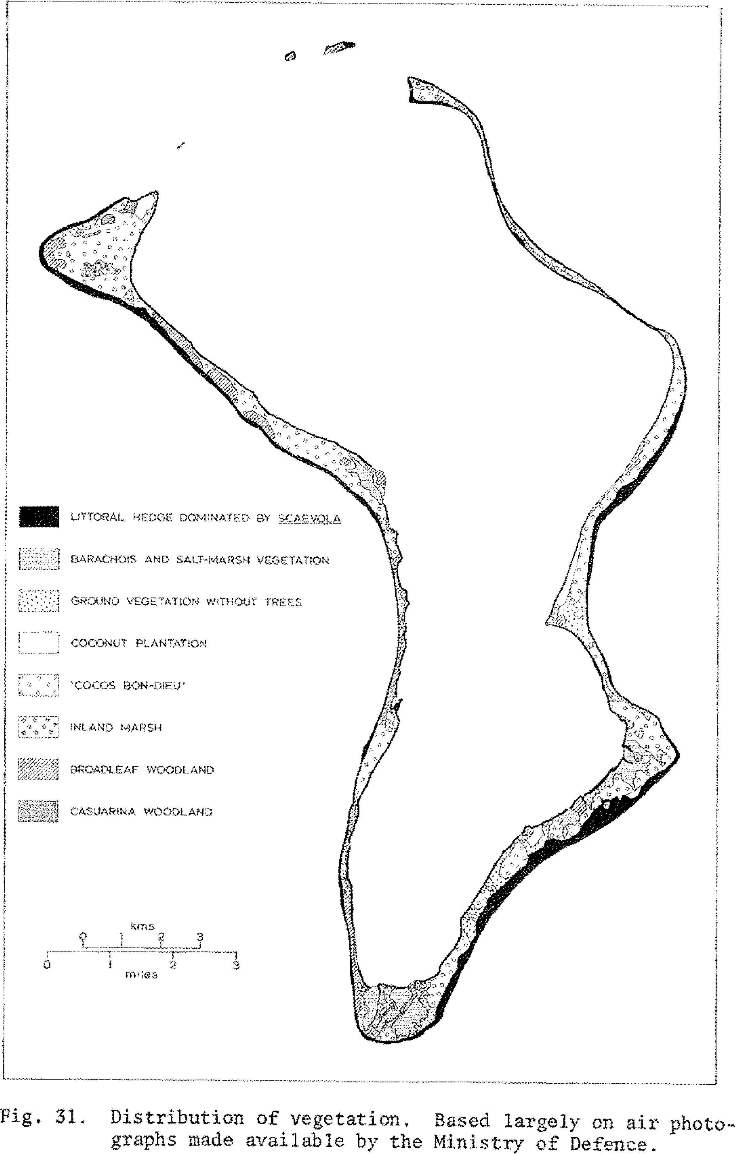
  2. Stoddart, D.R. Geomorphology of Diego Garcia Atoll. Atoll Res. Bull 1971, 149, 1–237. [Google Scholar]
  3. East, H. Personal communication. 2013. [Google Scholar]
  4. Sheppard, C. Seawater Inundations in the Chagos Archipelago at High Tides, and Shoreline Erosion; Report for British Indian Ocean Territory Administration;. Chagos Conservation Trust: London, UK, 2012; pp. 1–14. Available online: http://chagos-trust.org/sites/default/files/images/DG%20shoreline%20changes.pdf (accessed on 21 November 2013).
Figure 1. The map of Diego Garcia from Stoddart (1971) which was used to digitize the shoreline by Hamylton and East. Reprinted from Figure 31 of [2].
Remotesensing 06 02463f1
Figure 2. Hardwoods with large canopies now overhang the beach, instead of smaller canopied palms. These overhangs alone can add a few tens of metres to any measurement of shoreline position that uses vegetation edge to define extent of land.
Remotesensing 06 02463f2
Figure 3. Erosion on a sheltered, lagoonal facing shoreline. The erosion is of mature, dark soil, not transient white sand banks.
Remotesensing 06 02463f3
Figure 4. Sheltered, lagoon facing shore showing ingress of white sand onto the island. The raised ridge that mostly separates the beach from the interior of the island has disappeared along considerable lengths of the lagoon facing shore.
Remotesensing 06 02463f4

