Automated Extraction of the Archaeological Tops of Qanat Shafts from VHR Imagery in Google Earth
Abstract
:1. Introduction
2. Study Areas and Archaeological Circular Marks
2.1. Study Area
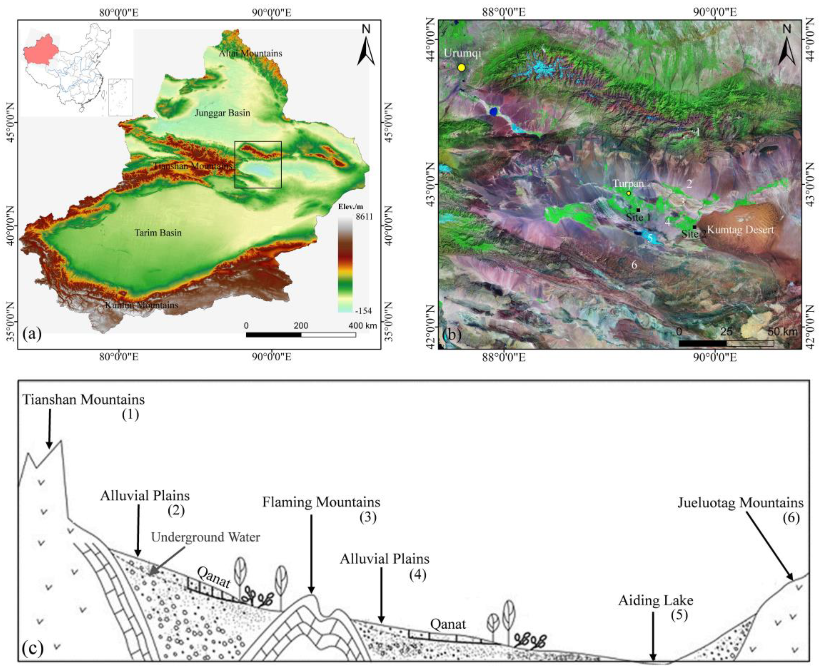
2.2. Circular Archaeological Traces: Tops of Qanat Shafts
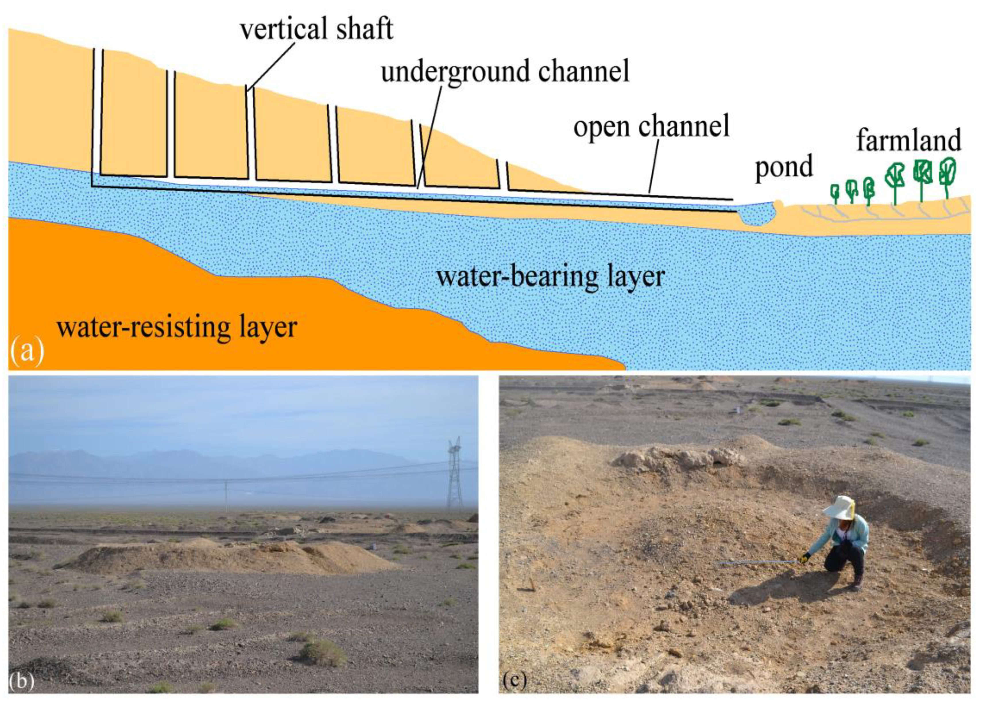
3. Data and Methods
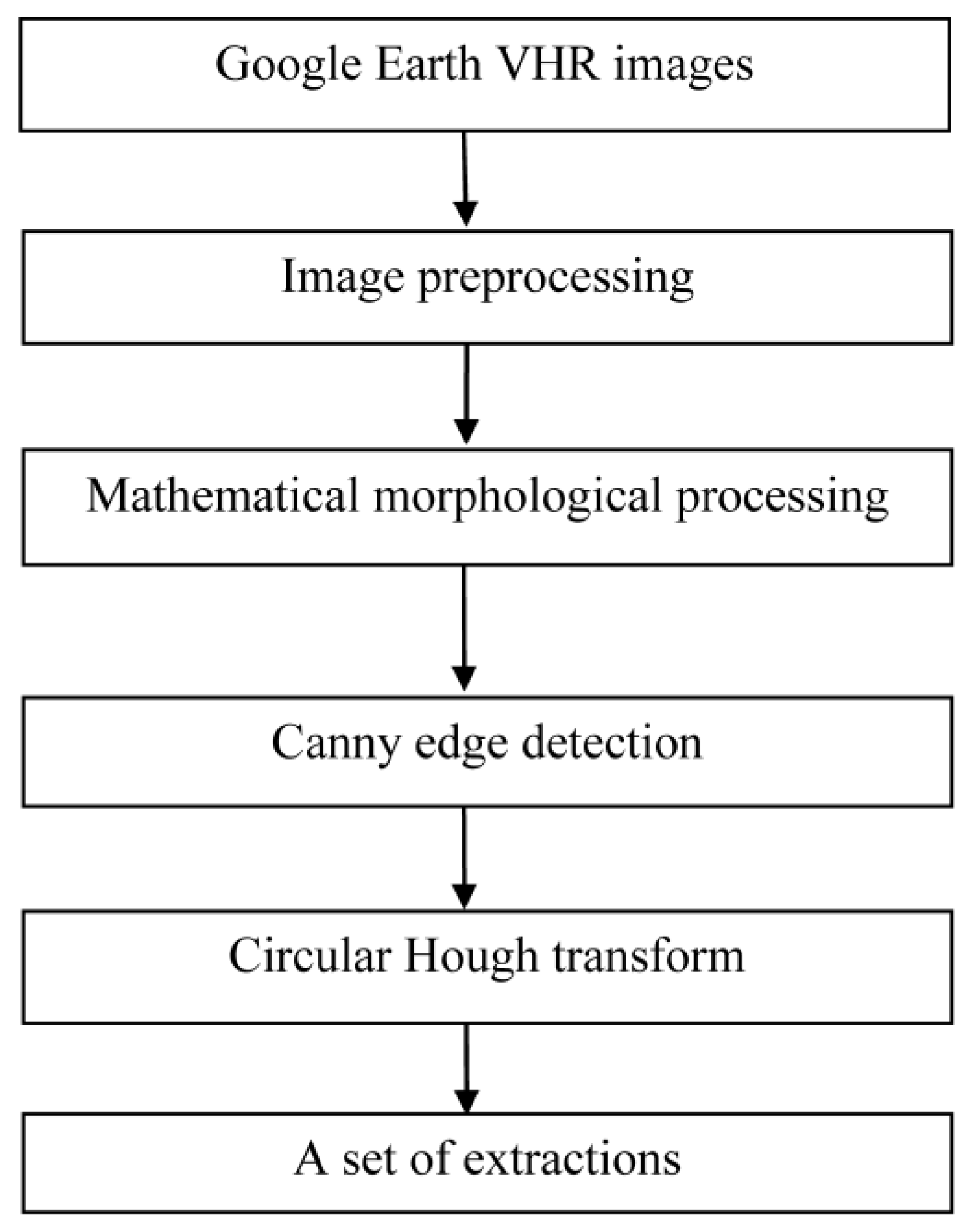
3.1. Google Earth VHR Images
3.2. Image Preprocessing
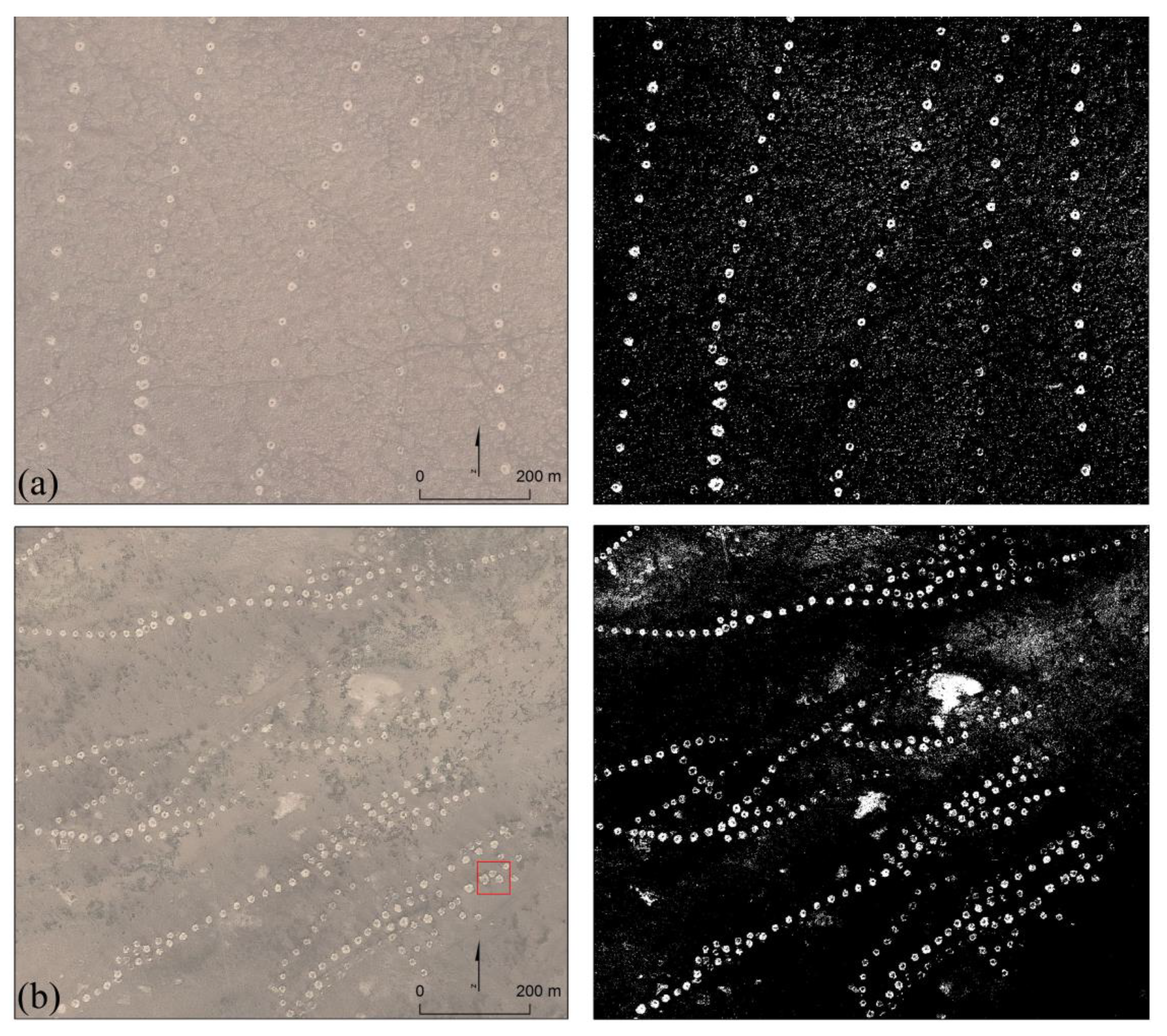
3.3. Mathematical Morphological Processing (MMP)
3.4. Edge Detection: Canny Edge Detector (CED)
3.5. Circular Hough Transform (CHT)
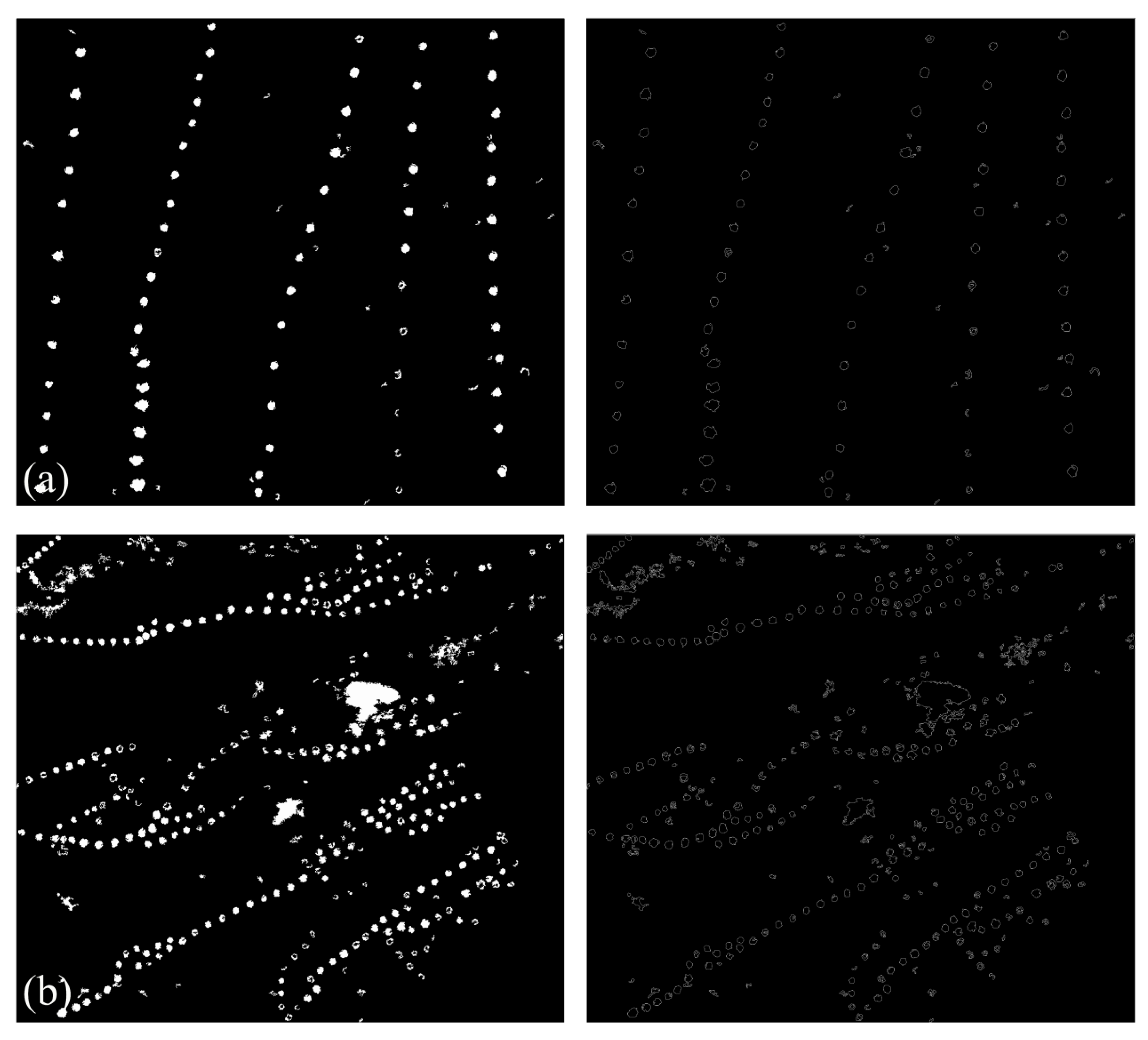
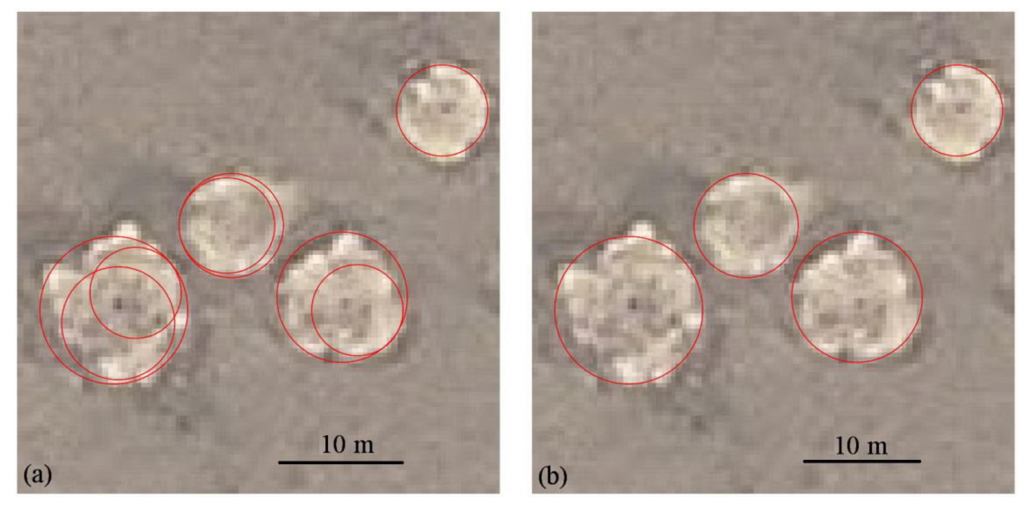
4. Results and Discussion
4.1. Results
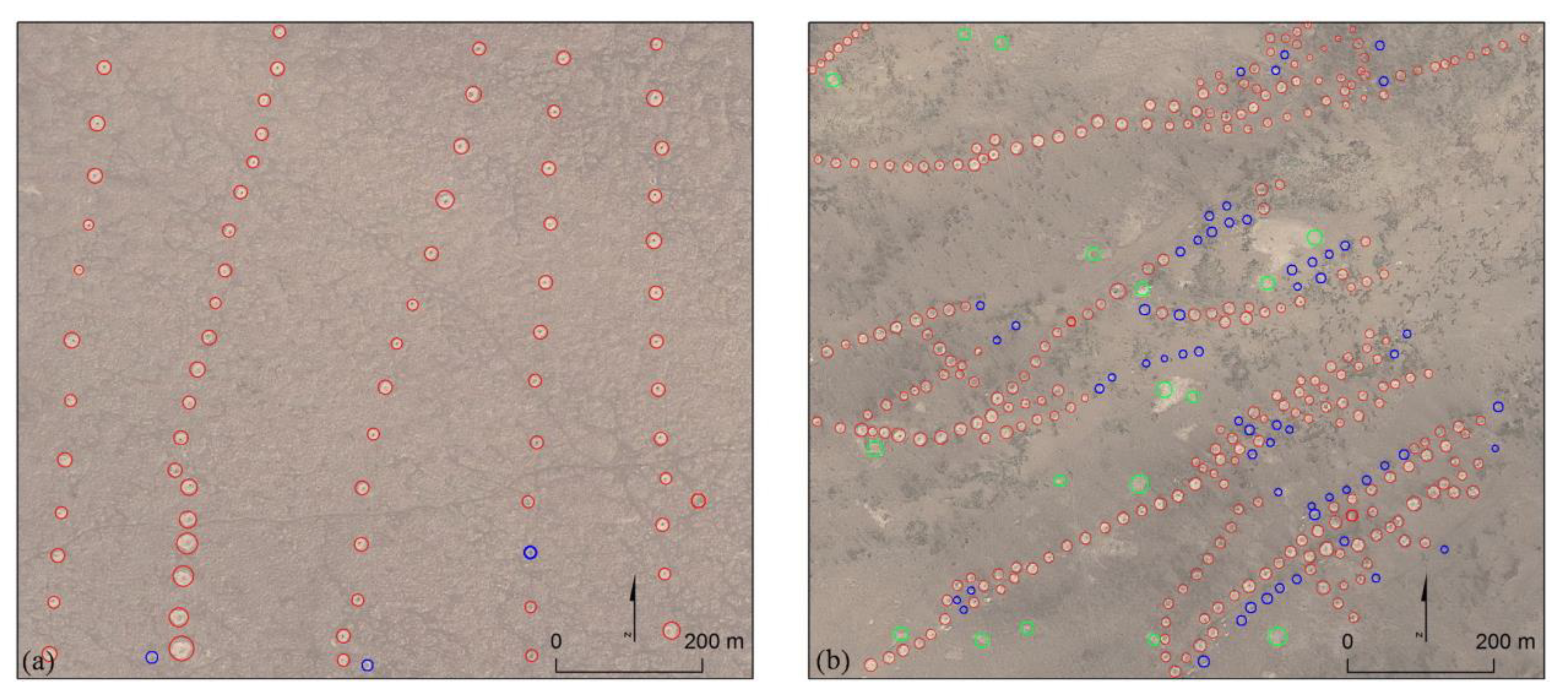
4.2. Quality Assessment
| Methods | GT | TE | FE | ME | E/% | B | Q/% | |
|---|---|---|---|---|---|---|---|---|
| Site 1 | Our proposed method | 74 | 71 | 0 | 3 | 95.9 | 0 | 95.9 |
| Standard CHT | 74 | 69 | 6 | 5 | 93.2 | 0.087 | 86.3 | |
| Site 2 | Our proposed method | 349 | 291 | 17 | 58 | 83.4 | 0.058 | 79.5 |
| Standard CHT | 349 | 265 | 54 | 84 | 75.9 | 0.204 | 65.8 |
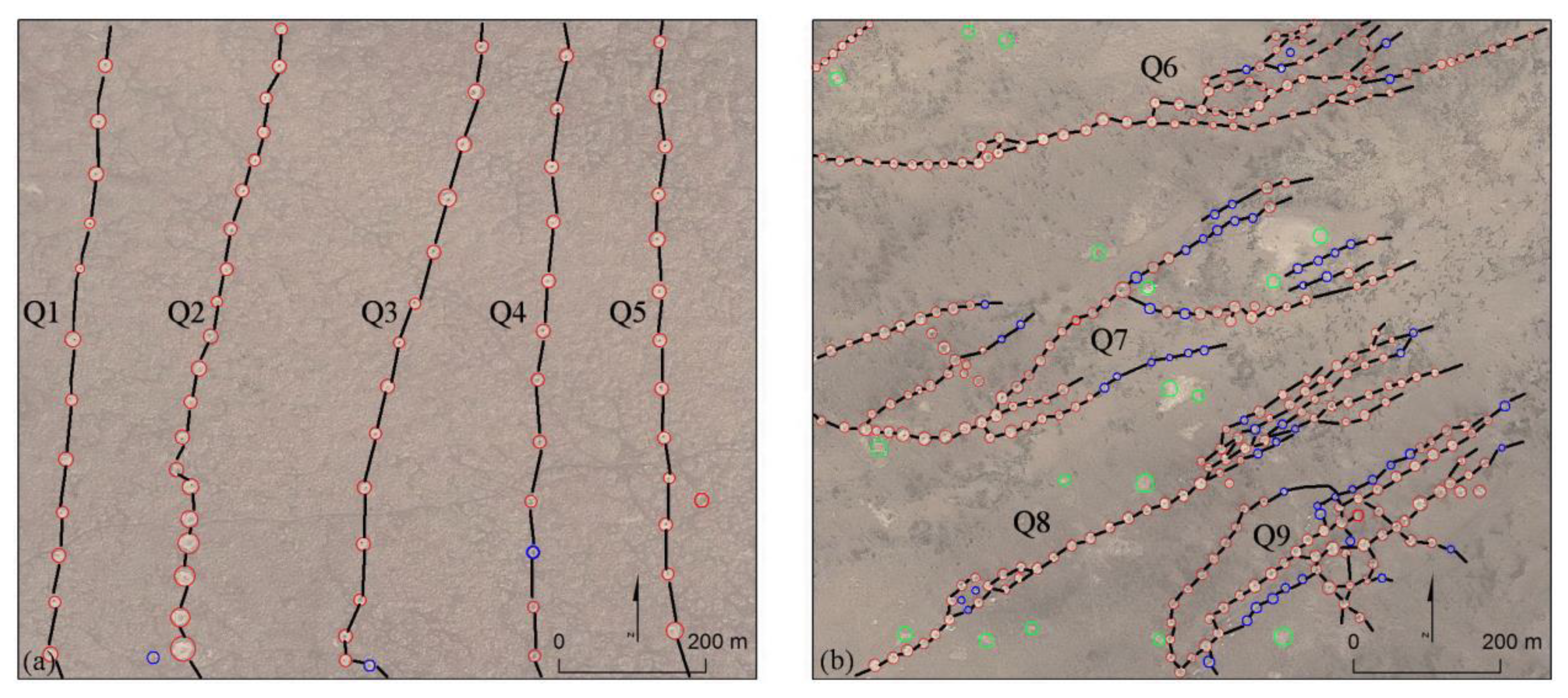
4.3. Mapping the Qanats
| Qanat | Number of TQSs | Average Distances between Two Adjacent TQSS | Normalized Number of TQSs | Normalized Average Distance | |
|---|---|---|---|---|---|
| Site 1 | Q1 | 12 | 54 | 0.00 | 1.000 |
| Q2 | 21 | 33 | 1.00 | 0.000 | |
| Q3 | 15 | 50 | 0.333 | 0.810 | |
| Q4 | 12 | 54 | 0.00 | 1.000 | |
| Q5 | 14 | 50 | 0.222 | 0.810 | |
| Site 2 | Q6 | 90 | 17 | 0.609 | 0.000 |
| Q7 | 99 | 20 | 1.000 | 1.000 | |
| Q8 | 76 | 19 | 0.000 | 0.667 | |
| Q9 | 84 | 18 | 0.348 | 0.333 |
5. Conclusions
Acknowledgments
Author Contributions
Conflicts of Interest
References
- Wilson, D.R. Air Photo Interpretation for Archaeologists; St. Martin’s Press: New York, NY, USA, 2012. [Google Scholar]
- Lasaponara, R.; Masini, N. Remote sensing in archaeology: From visual data interpretation to digital data manipulation. In Satellite Remote Sensing: A New Tool for Archaeology; Springer: New York, NY, USA, 2012; pp. 3–16. [Google Scholar]
- Beazeley, G.A. Air photography in archaeology. Geogr. J. 1919, 53, 330–335. [Google Scholar] [CrossRef]
- Musson, C.; Driver, T.; Pert, T. Air photo applications in Wales, UK. Exploration, landscape analysis, conservation and public presentation. In Proceedings of the 2nd International Conference on Remote Sensing in Archaeology, Rome, Italy, 4–7 December, 2006.
- McCauley, J.F.; Schaber, G.G.; Breed, C.S.; Grolier, M.J.; Haynes, C.V.; Issawi, B.; Elachi, C.; Blom, R. Subsurface valleys and geoarchaeology of the eastern Sahara revealed by shuttle radar. Science 1982, 218, 1004–1020. [Google Scholar] [CrossRef] [PubMed]
- Moore, E.; Freeman, T.; Hensley, S. Spaceborne and airborne radar at Angkor: Introducing new technology to the ancient site. In Remote Sensing in Archaeology; Wiseman, J., El-Baz, F., Eds.; Springer: New York, NY, USA, 2007; pp. 185–216. [Google Scholar]
- Stewarta, C.; Lasaponara, R.; Schiavona, G. Multi-frequency, polarimetric SAR analysis for archaeological prospection. Int. J. Appl. Earth Obs. 2014, 28, 211–219. [Google Scholar] [CrossRef]
- Chase, A.F.; Chase, D.Z.; Fisher, C.T.; Leisz, S.J.; Weishampel, J.F. Geospatial revolution and remote sensing LiDAR in Mesoamerican archaeology. PNAS 2012, 109, 12916–12921. [Google Scholar] [CrossRef] [PubMed]
- Johnson, K.M.; Ouimet, W.B. Rediscovering the lost archaeological landscape of southern New England using airborne light detection and ranging (LiDAR). J. Archaeol. Sci. 2014, 43, 9–20. [Google Scholar] [CrossRef]
- Aqdus, S.A.; Hanson, W.S.; Drummond, J. The potential of hyperspectral and multi-spectral imagery to enhance archaeological cropmark detection: A comparative study. J. Archaeol. Sci. 2012, 39, 1915–1924. [Google Scholar] [CrossRef]
- Atzberger, C.; Wess, M.; Doneus, M.; Verhoeven, G. ARCTIS—A MATLAB® toolbox for archaeological imaging spectroscopy. Remote Sens. 2014, 6, 8617–8638. [Google Scholar] [CrossRef]
- Cavalli, R.M.; Colosi, F.; Palombo, A.; Pignatti, S.; Poscolieri, M. Remote hyperspectral imagery as a support to archaeological prospection. J. Cult. Herit. 2007, 8, 272–283. [Google Scholar] [CrossRef]
- Challis, K.; Kincey, M.; Howard, A.J. Airborne remote sensing of valley floor geoarchaeology using Daedalus ATM and CASI. Archaeol. Prospect. 2009, 16, 17–33. [Google Scholar] [CrossRef]
- De Laet, V.; Paulissen, E.; Waelkens, M. Methods for the extraction of archaeological features from very high-resolution Ikonos-2 remote sensing imagery, Hisar (southwest Turkey). J. Archaeol. Sci. 2007, 34, 830–841. [Google Scholar] [CrossRef]
- Lasaponara, R.; Masini, N. Detection of archaeological crop marks by using satellite QuickBird multispectral imagery. J. Archaeol. Sci. 2007, 34, 214–221. [Google Scholar] [CrossRef]
- De Laet, V.; Paulissen, E.; Meuleman, K.; Waelkens, M. Effects of image characteristics on the identification and extraction of archaeological features from Ikonos-2 and Quickbird-2 imagery: Case study Sagalassos (southwest Turkey). Int. J. Remote Sens. 2009, 30, 5655–5668. [Google Scholar] [CrossRef]
- Lasaponara, R.; Masini, N. Pattern recognition and classification using VHR data for archaeological research. In Satellite Remote Sensing: A New Tool for Archaeology; Springer: New York, NY, USA, 2012; pp. 65–85. [Google Scholar]
- Noviello, M.; Ciminale, M.; Pasquale, V.D. Combined application of pansharpening and enhancement methods to improve archaeological cropmark visibility and identification in QuickBird imagery: Two case studies from Apulia, Southern Italy. J. Archaeol. Sci. 2013, 40, 3604–3613. [Google Scholar] [CrossRef]
- Lasaponara, R.; Masini, N. Beyond modern landscape features: New insights in the archaeological area of Tiwanaku in Bolivia from satellite data. Int. J. Appl. Earth Obs. Geoinf. 2014, 26, 464–471. [Google Scholar] [CrossRef]
- Luo, L.; Wang, X.; Liu, C.; Guo, H.; Du, X. Integrated RS, GIS and GPS approaches to archaeological prospecting in the Hexi Corridor, NW China: A case study of the royal road to ancient Dunhuang. J. Archaeol. Sci. 2014, 50, 178–190. [Google Scholar] [CrossRef]
- Wonsok, K.; Nie, Y.; Zhu, J.; Deng, B.; Yu, L.; Liu, F.; Gao, H. Local orientation based detection of circular soil marks of ancient graves by GA. J. Remote Sens. 2013, 17, 671–678. [Google Scholar]
- Myers, A. Camp Delta, Google Earth and the ethics of remote sensing in archaeology. World Archaeol. 2010, 42, 455–467. [Google Scholar] [CrossRef]
- Sheppard, S.; Cizek, P. The ethics of Google Earth: Crossing thresholds from spatial data to landscape visualization. J. Environ. Manage. 2008, 90, 2102–2117. [Google Scholar] [CrossRef] [PubMed]
- Parks, L. Digging into Google Earth: An analysis of “Crisis in Darfur”. Geoforum 2009, 40, 535–545. [Google Scholar] [CrossRef]
- Kennedy, D.; Bishop, M.C. Google Earth and the archaeology of Saudi Arabia, a case study from the Jeddah area. J. Archaeol. Sci. 2011, 38, 1284–1293. [Google Scholar] [CrossRef]
- Sadr, K.; Rodier, X. Google Earth, GIS and stone-walled structures in southern Gauteng, South Africa. J. Archaeol. Sci. 2012, 39, 1034–1042. [Google Scholar] [CrossRef]
- Kempe, S.; Al-Malabeh, A. Desert kites in Jordan and Saudi Arabia: Structure, statistics and function, a Google Earth study. Quat. Int. 2012, 297, 126–146. [Google Scholar] [CrossRef]
- Pringle, H. Google Earth shows clandestine worlds. Science 2010, 329, 1008–1009. [Google Scholar] [CrossRef] [PubMed]
- Ur, J. Google Earth and archaeology. SAA Record 2006, 6, 35–38. [Google Scholar]
- Luo, L.; Wang, X.; Cai, H.; Li, C.; Ji, W. Mapping a paleodrainage system of the Keriya River using remote sensing data and historical materials. J. Earth Sci. Eng. 2012, 2, 712–721. [Google Scholar]
- Morehart, C.T. Mapping ancient chinampa landscapes in the Basin of Mexico: A remote sensing and GIS approach. J. Archaeol. Sci. 2012, 39, 2541–2551. [Google Scholar] [CrossRef]
- Evans, D.; Pottier, C.; Fletcher, R.; Hensley, S.; Tapley, I.; Milne, A.; Barbetti, M. A comprehensive archaeological map of the world’s largest preindustrial settlement complex at Angkor, Cambodia. Proc. Natl. Acad. Sci. USA 2007, 104, 14277–14282. [Google Scholar] [CrossRef] [PubMed]
- Doneus, M.; Verhoeven, G.; Atzberger, C.; Wess, M.; Ruš, M. New ways to extract archaeological information from hyperspectral pixels. J. Archaeol. Sci. 2014, 52, 84–96. [Google Scholar] [CrossRef]
- D’Orazio, T.; Palumbo, F.; Guaragnell, C. Archaeological trace extraction by a local directional active contour approach. Pattern Recogn. 2012, 45, 3427–3438. [Google Scholar] [CrossRef]
- Lasaponara, R.; Masini, N. Satellite remote sensing in archaeology: Past, present and future perspectives. J. Archaeol. Sci. 2011, 38, 1995–2496. [Google Scholar] [CrossRef]
- Lasaponara, R.; Masini, N. Image enhancement, feature extraction and geospatial analysis in an archaeological perspective. In Satellite Remote Sensing: A New Tool for Archaeology; Springer: New York, NY, USA, 2012; pp. 17–63. [Google Scholar]
- Agapiou, A.; Alexakis, D.D.; Sarris, A.; Hadjimitsis, D.G. Orthogonal equations of multi-spectral satellite imagery for the identification of un-excavated archaeological sites. Remote Sens. 2013, 5, 6560–6586. [Google Scholar] [CrossRef]
- Tarantino, E.; Figorito, B. Steerable filtering in interactive tracing of archaeological linear features using digital true colour aerial images. Int. J. Digital Earth 2014, 7, 870–880. [Google Scholar] [CrossRef]
- Redfern, S.; Lyons, G. The Application of Digital Techniques to the Detection and Extraction of Archaeological Earthwork Monuments from Aerial Photographs. 1998. Available online: www.it.nuigalway.ie (accessed on 6 November 2013).
- Jahjah, M.; Ulivieri, C. Automatic archaeological feature extraction from satellite VHR images. Acta Astronaut. 2010, 66, 1302–1310. [Google Scholar] [CrossRef]
- Schuetter, J.; Goel, P.; McCorriston, J.; Park, J.; Senn, M.; Harrower, M. Autodetection of ancient Arabian tombs in high-resolution satellite imagery. Int. J. Remote Sens. 2013, 34, 6611–6635. [Google Scholar] [CrossRef]
- Trier, Ø.D.; Larsen, S.Ø.; Solberg, R. Automatic detection of circular structures in high-resolution satellite images of agricultural land. Archaeol. Prospect. 2009, 16, 1–15. [Google Scholar] [CrossRef]
- Figorito, B.; Tarantino, E. Semi-automatic detection of linear archaeological traces from orthorectified aerial images. Int. J. Appl. Earth Obs. 2014, 26, 458–463. [Google Scholar] [CrossRef]
- Pasolli, E.; Melgani, F.; Donelli, M.; Attoui, R.; de Vos, M. Automatic detection and classification of buried objects in GPR images using Genetic Algorithms and Support Vector Machines. In Proceedings of the 2008 IEEE International Geoscience and Remote Sensing Symposium, Boston, MA, USA, 7–11 July 2008; pp. II-525–II-528.
- Todd, D.K.; Mays, L.W. Introduction. In Groundwater Hydrology, 3rd ed.; Wiley: New York, NY, USA, 2004; pp. 7–41. [Google Scholar]
- Boustani, F. Sustainable water utilization in arid region of Iran by Qanats. Int. J. Human Soc. Sci. 2009, 4, 505–508. [Google Scholar]
- Karez: Afghanistan’s Traditional Irrigation System. Available online: http://www.adkn.org/en/agriculture/article.asp?a=67 (accessed on 25 September 2014).
- Ahmadi, H.; Samani, A.N.; Malekian, A. The Qanat: A living history in Iran. In Water and Sustainability in Arid Regions; Schneier-Madanes, G., Courel, M.F., Eds.; Springer: Landon, UK, 2010; pp. 125–138. [Google Scholar]
- Motiee, H.; Mcbean, E.; Semsar, A.; Gharabaghi, B.; Ghomashchi, V. Assessment of the contributions of Traditional Qanats in sustainable water resources management. Int. J. Water Res. Develop. 2006, 22, 575–588. [Google Scholar] [CrossRef]
- Abudu, S.; Cevik, S.Y.; Bawazir, S.; King, J.P.; Cui, C. Vitality of ancient Karez systems in arid lands: A case study in Turpan region of China. Water Hist. 2011, 3, 213–225. [Google Scholar] [CrossRef]
- Hu, W.; Zhang, J.; Liu, Y. The Qanats of Xinjiang: Historical development, characteristics and modern implications for environmental protection. J. Arid Land 2012, 4, 211–220. [Google Scholar] [CrossRef]
- Huang, S. Oasis Studies; Science Press: Beijing, China, 2003; pp. 3–17. (In Chinese) [Google Scholar]
- Li, J. A study on the origin and date of Xinjiang’s Kan’erjing. J. Xinjiang Norm. Univ. Soc. Sci. 2005, 26, 25–28. (In Chinese) [Google Scholar]
- Hosseini, S.A.; Shahraki, S.Z.; Farhudi, R.; Hosseini, S.M.; Salari, M.; Pourahmad, A. Effect of urban sprawl on a traditional water system (Qanat) in the City of Mashhad, NE Iran. Urb. Water J. 2010, 7, 309–320. [Google Scholar] [CrossRef]
- Haakon, L.; Shen, Y. The Disappearance of the Karez of Turfan; Report from the Project “Harvest from Wasteland. Land, People and Water Management Reforms in the Dry Lands of Xinjiang”; Acta Geographica Series A15; Department of Geography, Norwegian University of Science and Technology (NTNU): Trondheim, Norway, 2006. [Google Scholar]
- Haralick, R.M.; Sternberg, S.R.; Zhuang, X. Image analysis using mathematical morphology. IEEE Trans. Pattern Anal. Mach. Intell. 1987, PAMI-9, 532–550. [Google Scholar] [CrossRef]
- Gonzalez, R.C.; Woods, R.E. Morphological Image Processing. In Digital Image Processing, 2nd ed.; Prentice Hall: Upper Saddle River, NJ, USA, 2002; pp. 462–463. [Google Scholar]
- Maini, R.; Aggarwal, H. Study and comparison of various image edge detection techniques. Int. J. Image Process. 2009, 3, 1–11. [Google Scholar] [CrossRef]
- Rahnama, M.; Gloaguen, R. TecLines: A MATLAB-based toolbox for tectonic lineament analysis from satellite images and DEMs, part 1: Line segment detection and extraction. Remote Sens. 2014, 6, 5938–5958. [Google Scholar] [CrossRef]
- Canny, J. A computational approach to edge detection. IEEE Trans. Pattern Anal. Mach. Intell. 1986, PAMI-8, 679–698. [Google Scholar] [CrossRef]
- Hough, P.V.C. Method and Means for Recognizing Complex Patterns. U.S. Patent 3,069,654, 18 December 1962. [Google Scholar]
- Yuen, H.K.; Illingworth, J.; Kittler, J. Detecting partially occluded ellipses using the Hough transform. Image Vision Comput. 1989, 7, 31–37. [Google Scholar] [CrossRef]
- Rizon, M.; Yazid, H.; Saad, P.; Md Shakaff, A.Y.; Saad, A.R.; Sugisaka, M.; Yaacob, S.; Mamat, M.R.; Karthigayan, M. Object detection using circular Hough transform. Am. J. Appl. Sci. 2005, 2, 1606–1609. [Google Scholar] [CrossRef]
- Raymond, K.K.Y.; Peter, K.S.T.; Dennis, N.K.L. Modification of Hough transform for circles and ellipses detection using a 2-dimensional array. Pattern Recogn. 1992, 25, 1007–1022. [Google Scholar] [CrossRef]
- Duda, R.O.; Hart, P.E. Use of the Hough transform to detect lines and curves in pictures. Commun. ACM 1972, 15, 11–15. [Google Scholar] [CrossRef]
- Shufelt, J.A. Performance evaluation and analysis of monocular building extraction from Aerial imagery. IEEE Trans. Pattern Anal. Mach. Intell. 1999, 21, 311–326. [Google Scholar] [CrossRef]
© 2014 by the authors; licensee MDPI, Basel, Switzerland. This article is an open access article distributed under the terms and conditions of the Creative Commons Attribution license (http://creativecommons.org/licenses/by/4.0/).
Share and Cite
Luo, L.; Wang, X.; Guo, H.; Liu, C.; Liu, J.; Li, L.; Du, X.; Qian, G. Automated Extraction of the Archaeological Tops of Qanat Shafts from VHR Imagery in Google Earth. Remote Sens. 2014, 6, 11956-11976. https://doi.org/10.3390/rs61211956
Luo L, Wang X, Guo H, Liu C, Liu J, Li L, Du X, Qian G. Automated Extraction of the Archaeological Tops of Qanat Shafts from VHR Imagery in Google Earth. Remote Sensing. 2014; 6(12):11956-11976. https://doi.org/10.3390/rs61211956
Chicago/Turabian StyleLuo, Lei, Xinyuan Wang, Huadong Guo, Chuansheng Liu, Jie Liu, Li Li, Xiaocui Du, and Guoquan Qian. 2014. "Automated Extraction of the Archaeological Tops of Qanat Shafts from VHR Imagery in Google Earth" Remote Sensing 6, no. 12: 11956-11976. https://doi.org/10.3390/rs61211956
APA StyleLuo, L., Wang, X., Guo, H., Liu, C., Liu, J., Li, L., Du, X., & Qian, G. (2014). Automated Extraction of the Archaeological Tops of Qanat Shafts from VHR Imagery in Google Earth. Remote Sensing, 6(12), 11956-11976. https://doi.org/10.3390/rs61211956


