Using InSAR Coherence to Map Stand Age in a Boreal Forest

Abstract
:1. Introduction
1.1. Motivation
1.2. Modeling Forest Structure from InSAR Coherence Maps
1.3. Remote Sensing Data
2. Methods
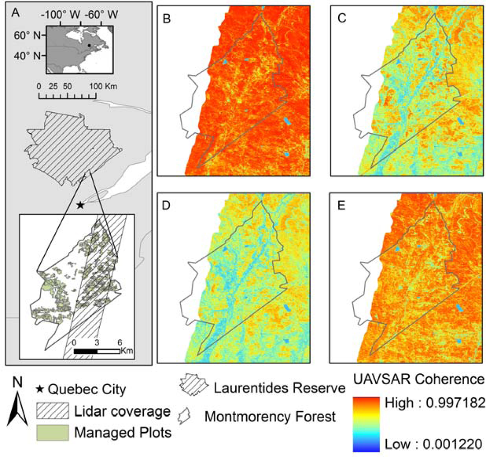
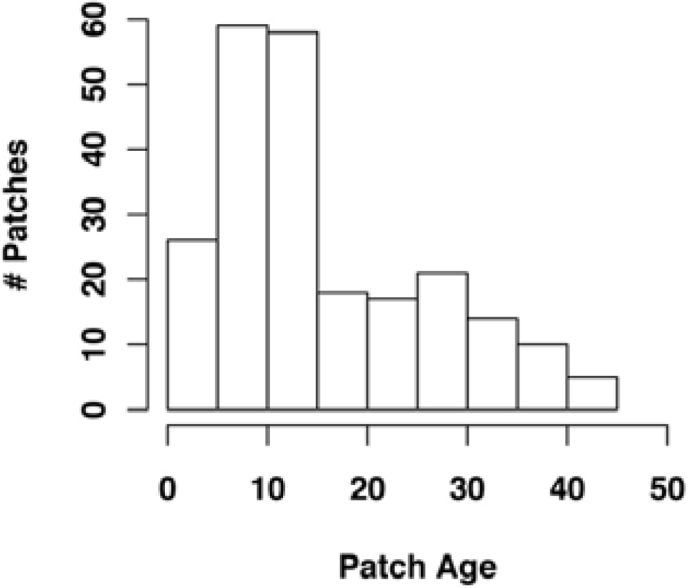
2.1. Study Site
2.2. UAVSAR Correlation and Backscatter
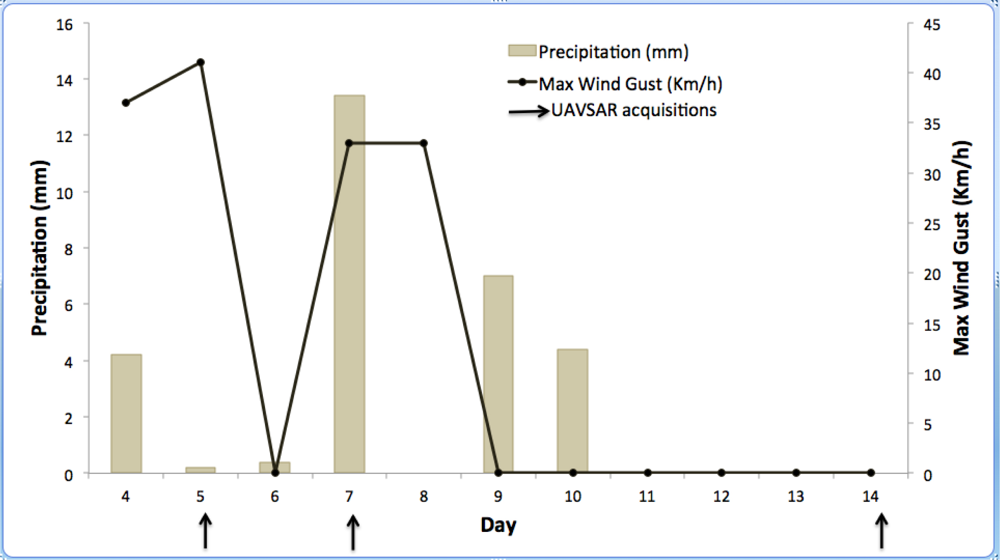
2.3. Weather Data
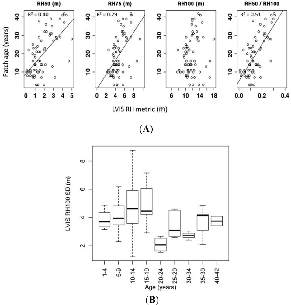
2.4. Canopy Height and Height Metrics
2.5. GIS and Statistical Analyses
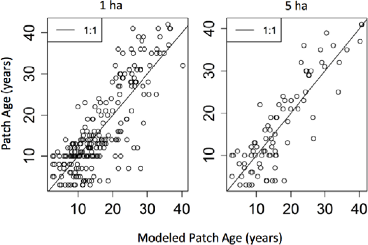
3. Results
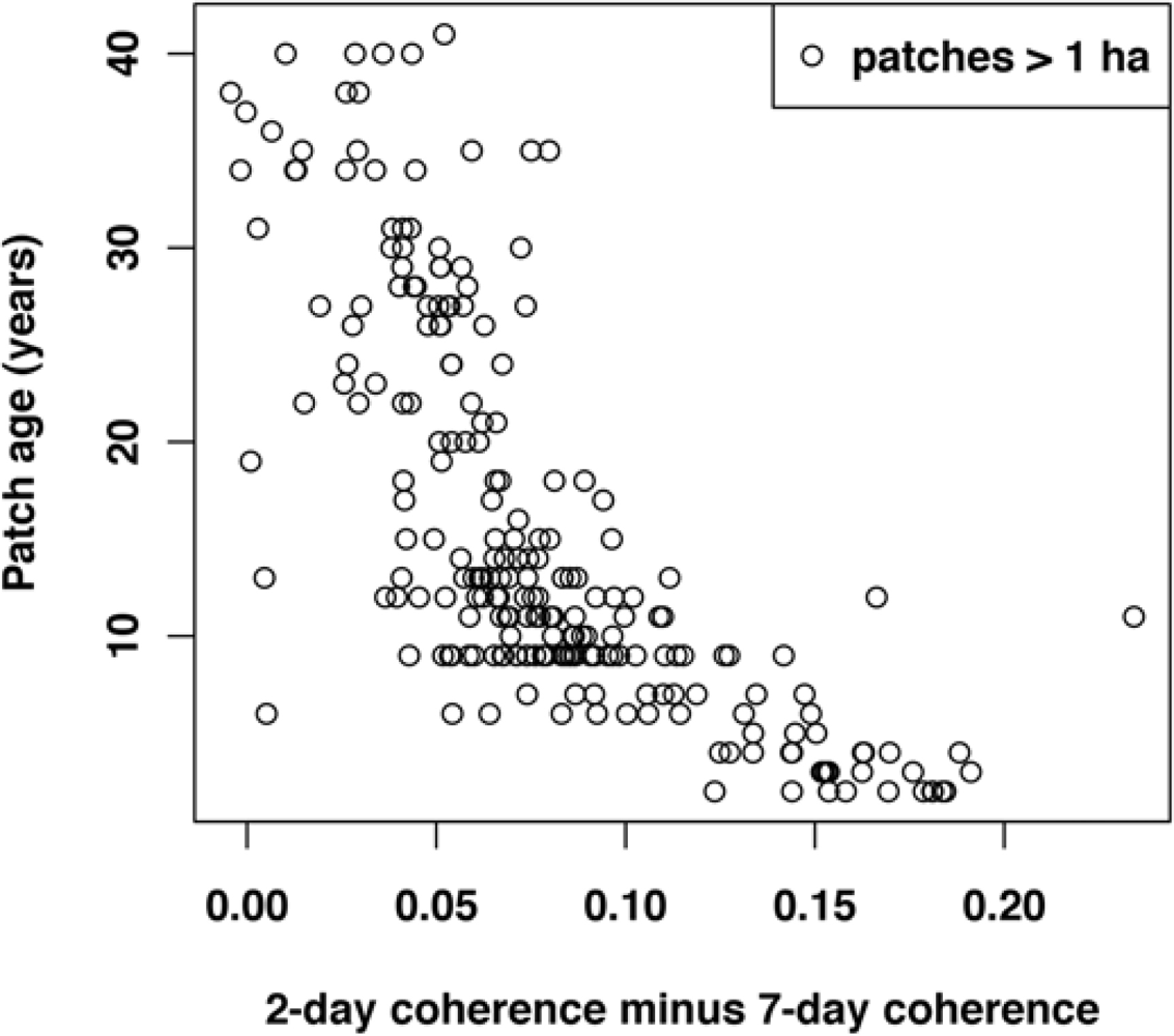
4. Discussion
5. Conclusions
Acknowledgments
References
- Canadell, J.G.; Le Quere, C.; Raupach, M.R.; Field, C.B.; Buitenhuis, E.T.; Ciais, P.; Conway, T.J.; Gillett, N.P.; Houghton, R.A.; Marland, G. Contributions to accelerating atmospheric CO2 growth from economic activity, carbon intensity, and efficiency of natural sinks. Proc. Natl. Acad. Sci. USA 2007, 104, 18866–18870. [Google Scholar]
- Le Quere, C.; Raupach, M.R.; Canadell, J.G.; Marland, G.; Bopp, L.; Ciais, P.; Conway, T.J.; Doney, S.C.; Feely, R.A.; Foster, P.; et al. Trends in the sources and sinks of carbon dioxide. Nat. Geosci 2009, 2, 831–836. [Google Scholar]
- Pan, Y.; Birdsey, R.A.; Fang, J.; Houghton, R.; Kauppi, P.E.; Kurz, W.A.; Phillips, O.L.; Shvidenko, A.; Lewis, S.L.; Canadell, J.G.; et al. A large and persistent carbon sink in the world’s forests. Science 2011, 333, 988–993. [Google Scholar]
- Hansen, M.C.; Stehman, S.V.; Potapov, P.V. Quantification of global gross forest cover loss. PNAS 2010, 107, 8650–8655. [Google Scholar]
- Houghton, R.A. Why are estimates of the terrestrial carbon balance so different? Glob. Change Biol 2003, 9, 500–509. [Google Scholar]
- Dolan, K.; Masek, J.G.; Huang, C.; Sun, G. Regional forest growth rates measured by combining ICESat GLAS and Landsat data. J. Geophys. Res.-Biogeosci. 2009. [Google Scholar] [CrossRef]
- Li, A.; Huang, C.; Sun, G.; Shi, H.; Toney, C.; Zhu, Z.; Rollins, M.G.; Goward, S.N.; Masek, J.G. Modeling the height of young forests regenerating from recent disturbances in Mississippi using Landsat and ICESat data. Remote Sens. Environ 2011, 115, 1837–1849. [Google Scholar]
- Huang, C.; Coward, S.N.; Masek, J.G.; Thomas, N.; Zhu, Z.; Vogelmann, J.E. An automated approach for reconstructing recent forest disturbance history using dense Landsat time series stacks. Remote Sens. Environ 2010, 114, 183–198. [Google Scholar]
- Champion, I.; Dubois-Fernandez, P.; Guyon, D.; Cottrel, M. Radar image texture as a function of forest stand age. Int. J. Remote Sens 2008, 29, 1795–1800. [Google Scholar]
- Kuplich, T.M. Classifying regenerating forest stages in Amazonia using remotely sensed images and a neural network. Forest Ecol. Manage 2006, 234, 1–9. [Google Scholar]
- Luckman, A.J.; Frery, A.C.; Yanasse, C.C.F.; Groom, G.B. Texture in airborne SAR imagery of tropical forest and its relationship to forest regeneration stage. Int. J. Remote Sens 1997, 18, 1333–1349. [Google Scholar]
- McNeill, S.; Pairman, D. Stand age retrieval in production forest stands in New Zealand using C-and L-band polarimetric radar. IEEE Trans. Geosci. Remote Sens 2005, 43, 2503–2515. [Google Scholar]
- Salas, W.A.; Ducey, M.J.; Rignot, E.; Skole, D. Assessment of JERS-1 SAR for monitoring secondary vegetation in Amazonia: I. Spatial and temporal variability in backscatter across a chrono-sequence of secondary vegetation stands in Rondonia. Int. J. Remote Sens 2002, 23, 1357–1379. [Google Scholar]
- Quegan, S.; Le Toan, T.; Yu, J.J.; Ribbes, F.; Floury, N. Multitemporal ERS SAR analysis applied to forest mapping. IEEE Trans. Geosci. Remote Sens 2000, 38, 741–753. [Google Scholar]
- Rosen, P.A.; Hensley, S.; Joughin, I.R.; Li, F.K.; Madsen, S.N.; Rodriguez, E.; Goldstein, R.M. Synthetic aperture radar interferometry. Proc. IEEE 2000, 88, 333–382. [Google Scholar]
- Zebker, H.A.; Werner, C.L.; Rosen, P.A.; Hensley, S. Accuracy of topographic maps derived from Ers-1 Interferometric Radar. IEEE Trans. Geosci. Remote Sens 1994, 32, 823–836. [Google Scholar]
- Zebker, H.A.; Villasenor, J. Decorrelation in interferometric radar echoes. IEEE Trans. Geosci. Remote Sens 1992, 30, 950–959. [Google Scholar]
- Askne, J.I.H.; Dammert, P.B.G; Ulander, L.M.H.; Smith, G. C-band repeat-pass interferometric SAR observations of the forest. IEEE Trans. Geosci. Remote Sens 1997, 35, 25–35. [Google Scholar]
- Santoro, M.; Askne, J.; Smith, G.; Fransson, J.E.S. Stem volume retrieval in boreal forests from ERS-1/2 interferometry. Remote Sens. Environ 2002, 81, 19–35. [Google Scholar]
- Askne, J.; Santoro, M.; Smith, G; Fransson, J.E.S. Multitemporal repeat-pass SAR interferometry of boreal forests. IEEE Trans. Geos. Remote Sens 2003, 41, 1540–1550. [Google Scholar]
- Castel, T.; Martinez, J.M.; Beaudoin, A.; Wegmuller, U.; Strozzi, T. ERS INSAR data for remote sensing hilly forested areas. Remote Sens. Environ 2000, 73, 73–86. [Google Scholar]
- Ahmed, R.; Siqueira, P.; Hensley, S.; Chapman, B.; Bergen, K. A survey of temporal decorrelation from spaceborne L-band repeat-pass InSAR. Remote Sens. Environ 2011, 115, 2887–2896. [Google Scholar]
- Lavalle, M.; Simard, M.; Hensley, S. A temporal decorrelation model for polarimetric radar interferometers. IEEE Trans. Geosci. Remote Sens 2012, 50, 2880–2888. [Google Scholar]
- Simard, M.; Hensley, S.; Lavalle, M.; Dubayah, R.; Pinto, N.; Hofton, M. An empirical assessment of temporal decorrelation using the Uninhabited Aerial Vehicle Synthetic Aperture Radar over forested landscapes. Remote Sens 2012, 4, 975–986. [Google Scholar]
- Hensley, S.; Lou, Y.; Rosen, P.; Wheeler, K.; Zebker, H.; Madsen, S.; Miller, T.; Hoffman, J.; Farra, D. An L-Band SAR for Repeat Pass Deformation Measurements on a UAV Platform. Proceedings of 2nd AIAA Unmanned-Unlimited System, Technologies and Operating-Aerospace, Land and Sea Conference and Workshop and Exhibit, San Diego, CA, USA, 20 September 2003.
- Simard, M.; Pinto, N.; Dubayah, R.; Hensley, S. UAVSAR’s First Campaign Over Temperate and Boreal Forests. Presentation at American Geophysical Union Fall Meeting, San Francisco, CA, USA, 15 December 2009.
- Blair, J.B.; Rabine, D.L.; Hofton, M.A. The laser vegetation imaging sensor: A medium-altitude, digitisation-only, airborne laser altimeter for mapping vegetation and topography. ISPRS J. Photogramm 1999, 54, 115–122. [Google Scholar]
- Drake, J.B.; Dubayah, R.O.; Clark, D.B.; Knox, R.G.; Blair, J.B.; Hofton, M.A.; Chazdon, R.L.; Weishampel, J.F.; Prince, S.D. Estimation of tropical forest structural characteristics using large-footprint lidar. Remote Sens. Environ 2002, 79, 305–319. [Google Scholar]
- Whittaker, J.W. Communities and Ecosystems; Macmillian: New York, NY, USA, 1975. [Google Scholar]
- Environment Canada. National Climate Data and Information Archive. Available online: www.climate.weatheroffice.gc.ca (assessed on 5 May 2012).
- Saucier, J.P.; Grondin, P.; Robitaille, A.; Bergeron, J.F. Vegetation Zones and Bioclimatic Domains in Québec. Available online: http://www.mrn.gouv.qc.ca/english/publications/forest/publications/zone-a.pdf (assessed on 5 May 2012).
- Messaoud, Y.; Bergeron, Y.; Leduc, A. Ecological factors explaining the location of the boundary between the mixedwood and coniferous bioclimatic zones in the boreal biome of eastern North America. Global Ecol. Biogeogr 2007, 16, 90–102. [Google Scholar]
- Carleton, T.J.; Maycock, P.F. Dynamics of boreal forest south of James Bay. Can. J. Bot 1978, 56, 1157–1173. [Google Scholar]
- Belanger, L. La foret mosaique comme strategie de conservation de la biodiversite de la sapiniere boreale de l’Est: L’experience de la Foret Montmorency. Le Naturalist Canadien 2001, 125, 18–25. [Google Scholar]
- Desponts, M.; Desrochers, A.; Belanger, L.; Huot, J. Structure of managed and old-growth fir stands in the Laurentian Mountains (Quebec) and diversity of nonvascular plants. Can. J. Forest Res 2002, 32, 2077–2093. [Google Scholar]
- Lee, S.; Ni-Meister, W; Yang, W; Chen, Q. Physically based vertical vegetation structure retrieval from ICESat data: Validation using LVIS in White Mountain National Forest, New Hampshire, USA. Remote Sens. Environ 2011, 115, 2776–2785. [Google Scholar]
- Swatantran, A.; Dubayah, R.; Roberts, D.; Hofton, M.; Blair, J.B. Mapping biomass and stress in the Sierra Nevada using lidar and hyperspectral data fusion. Remote Sens. Environ 2011, 115, 2917–2930. [Google Scholar]
- Anderson, J.; Martin, M.E.; Smith, M.L.; Dubayah, R.O.; Hofton, M.A.; Hyde, P.; Peterson, B.E.; Blair, J.B.; Knox, R.G. The use of waveform lidar to measure northern temperate mixed conifer and deciduous forest structure in New Hampshire. Remote Sens. Environ 2006, 105, 248–261. [Google Scholar]
- Santoro, M.; Shvidenko, A.; McCallum, I.; Askne, J.; Schmulius, C. Properties of ERS-1/2 coherence in the Siberian boreal forest and implications for stem volume retrieval. Remote Sens. Environ 2007, 106, 154–172. [Google Scholar]
- Chambers, J.M. Linear Models. In Statistical Models in S; Chambers, J.M., Hastie, T.J., Eds.; Chapter 4; Wadsworth & Brooks/Cole: Pacific Grove, CA, USA, 1992; pp. 95–144. [Google Scholar]
- Rignot, E.; Way, J.B.; Williams, C.; Viereck, L. Radar estimates of aboveground biomass in boreal forests of Interior Alaska. IEEE Trans. Geosci. Remote Sens 1994, 32, 1117–1124. [Google Scholar]
- Ranson, K.J.; Sun, G.Q.; Lang, R.H.; Chauhan, N.S.; Cacciola, R.J.; Kilic, O. Mapping of boreal forest biomass from spaceborne synthetic aperture radar. J. Geophys. Res.-Atmos 1997, 102, 29599–29610. [Google Scholar]
- Gaveau, D.L.A.; Balzter, H.; Plummer, S. Forest woody biomass classification with satellite-based radar coherence over 900,000 km2 in Central Siberia. Forest Ecol. Manage 2003, 174, 65–75. [Google Scholar]
- Tansey, K.J.; Luckman, A.J.; Skinner, L.; Balzter, H.; Strozzi, T.; Wagner, W. Classification of forest volume resources using ERS tandem coherence and JERS backscatter data. Int. J. Remote Sens 2004, 25, 751–768. [Google Scholar]
- Cartus, O.; Kellndorfer, J.; Rombach, M.; Walker, W. Mapping canopy height and growing stock volume using Airborne Lidar, ALOS PALSAR and Landsat ETM+. Remote Sens 2012, 4, 3320–3345. [Google Scholar]


| Acquisition Day (2009) | UAVSAR Pair | Temporal Baseline |
|---|---|---|
| 7 August | Laurnt_18801_09056_007_090807_L090*_CX_01.grd | 45 min |
| 7 August | Laurnt_18801_09056_005_090807_L090*_CX_01.grd | |
| 14 August | Laurnt_18801_09061_007_090814_L090*_CX_01.grd | 45 min |
| 14 August | Laurnt_18801_09061_005_090814_L090*_CX_01.grd | |
| 5 August | Laurnt_18801_09054_007_090805_L090*_CX_01.grd | 2 days |
| 7 August | Laurnt_18801_09056_007_090807_L090*_CX_01.grd | |
| 7 August | Laurnt_18801_09056_005_090807_L090*_CX_01.grd | 7 days |
| 14 August | Laurnt_18801_09061_007_090814_L090*_CX_01.grd | |
| 5 August | Laurnt_18801_09054_007_090805_L090*_CX_01.grd | 9 days |
| 14 August | Laurnt_18801_09061_007_090814_L090*_CX_01.grd |
| Predictor Variable | R2 | RMSE (years) | a | b | P |
|---|---|---|---|---|---|
| LVIS RH50 | 0.40 | 8.5 | 9.1 | 5.8 | <0.01 |
| LVIS RH75 | 0.29 | 9.2 | 0.8 | 3.9 | <0.01 |
| LVIS RH100 | 0.05 | 10.7 | 4.1 | 1.3 | 0.04 |
| LVIS RH50/RH100 | 0.51 | 7.6 | 5.1 | 100.4 | <0.01 |
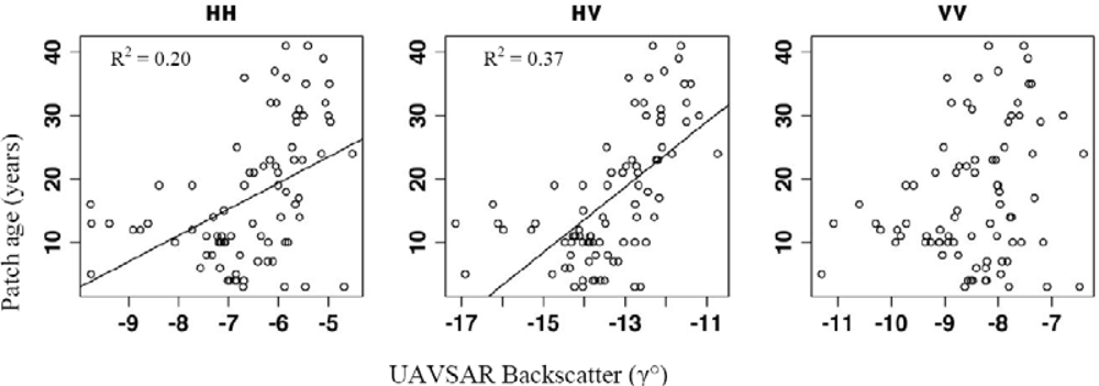
| UAVSAR Gamma naught HH | 0.20 | 9.5 | 44.1 | 4.1 | <0.01 |
| UAVSAR Gamma naught HV | 0.37 | 8.4 | 85.7 | 5.1 | <0.01 |
| UAVSAR Gamma naught VV | 0.06 | 10.3 | 41.5 | 2.9 | 0.02 |
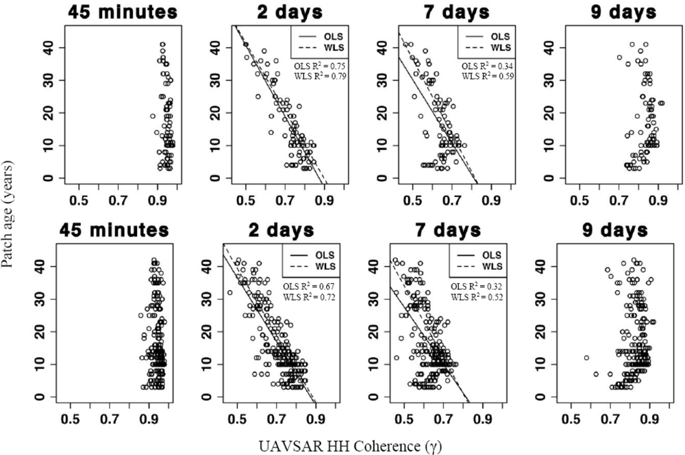
| UAVSAR coh HH 45 min | 0.03 | 10.4 | 126.3 | −115.5 | 0.058 |
| UAVSAR coh HH 2 days OLS | 0.75 | 5.3 | 95.3 | −109.2 | <0.01 |
| UAVSAR coh HH 2 days WLS | 0.79 | 19.8 | 93.7 | −104.4 | <0.01 |
| UAVSAR coh HH 7 days OLS | 0.34 | 8.6 | 78.7 | −97.1 | <0.01 |
| UAVSAR coh HH 7 days WLS | 0.59 | 27.9 | 94.0 | −115.1 | <0.01 |
| UAVSAR coh HH 9 days | <0.01 | 10.6 | −4.1 | 25.2 | 0.33 |
| Predictor Variable | R2 | RMSE (years) | a | b | P |
|---|---|---|---|---|---|
| LVIS RH50 | 0.07 | 10.2 | 13.4 | 2.2 | <0.01 |
| LVIS RH75 | 0.01 | 10.6 | 14.0 | 0.7 | 0.10 |
| LVIS RH100 | <0.01 | 10.6 | 20.1 | −0.2 | 0.46 |
| LVIS RH50/RH100 | 0.20 | 9.0 | 44.4 | 4.3 | <0.01 |
| UAVSAR Gamma naught HH | 0.20 | 9.1 | 42.6 | 4.0 | <0.01 |
| UAVSAR Gamma naught HV | 0.30 | 8.5 | 72.5 | 4.2 | <0.01 |
| UAVSAR Gamma naught VV | 0.10 | 9.7 | 42.0 | 3.1 | <0.01 |
| UAVSAR coh HH 45 min | 0.01 | 10.1 | 69.0 | −55.8 | 0.05 |
| UAVSAR coh HH 2 days OLS | 0.67 | 5.8 | 85.7 | −98.1 | <0.01 |
| UAVSAR coh HH 2 days WLS | 0.72 | 23.1 | 91.0 | −103.0 | <0.01 |
| UAVSAR coh HH 7 days OLS | 0.32 | 8.3 | 71.5 | −87.8 | <0.01 |
| UAVSAR coh HH 7 days WLS | 0.52 | 30.4 | 89.1 | −110.0 | <0.01 |
| UAVSAR coh HH 9 days | 0.01 | 10.1 | −4.3 | −25.0 | 0.07 |
Share and Cite
Pinto, N.; Simard, M.; Dubayah, R. Using InSAR Coherence to Map Stand Age in a Boreal Forest. Remote Sens. 2013, 5, 42-56. https://doi.org/10.3390/rs5010042
Pinto N, Simard M, Dubayah R. Using InSAR Coherence to Map Stand Age in a Boreal Forest. Remote Sensing. 2013; 5(1):42-56. https://doi.org/10.3390/rs5010042
Chicago/Turabian StylePinto, Naiara, Marc Simard, and Ralph Dubayah. 2013. "Using InSAR Coherence to Map Stand Age in a Boreal Forest" Remote Sensing 5, no. 1: 42-56. https://doi.org/10.3390/rs5010042
APA StylePinto, N., Simard, M., & Dubayah, R. (2013). Using InSAR Coherence to Map Stand Age in a Boreal Forest. Remote Sensing, 5(1), 42-56. https://doi.org/10.3390/rs5010042