Snow Cover Maps from MODIS Images at 250 m Resolution, Part 1: Algorithm Description

 , ,
, ,
Abstract
:
1. Introduction
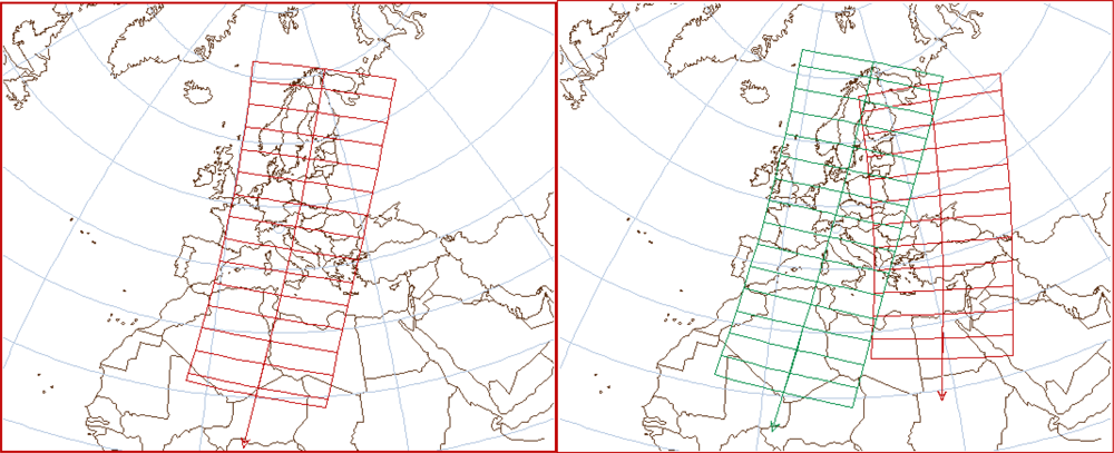
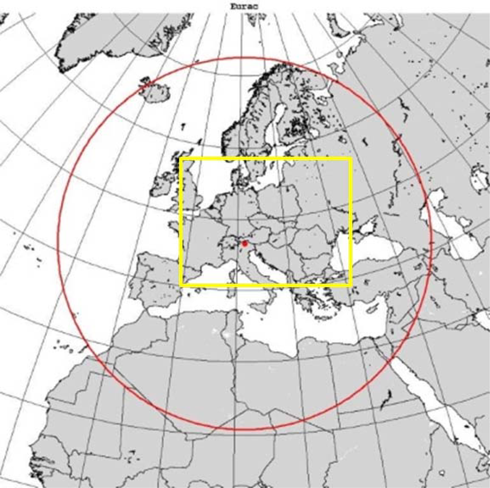
2. Study Area and Data
- - MOD09GQ–MYD09GQ and MOD09GA–MYD09GA (Terra–Aqua): atmospherically corrected surface reflectance product at 250 m–500 m resolution. The 250 m resolution bands, band 1 (0.62–0.67 μm) and 2 (0.841–0.876 μm), are used to detect snow and snow in forested areas. The 500 m resolution bands, bands 4 (0.545–0.565 μm) and 6 (1.628–1.652 μm) are used to detect clouds along with 1 km resolution bands.
- - MOD021KM–MYD021KM (Terra–Aqua): reflectance bands at 1 km resolution for cloud detection. The 1 km resolution bands are: 20 (3.660–3.840 μm), 21 (3.929–3.989 μm), 31 (10.780–11.280 μm), 32 (11.770–12.270 μm), 26 (1.360–1.390 μm).
- - MOD03–MYD03 (Terra–Aqua): Geo-location dataset.
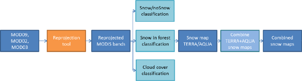
3. MODIS 250 m SCA Algorithm
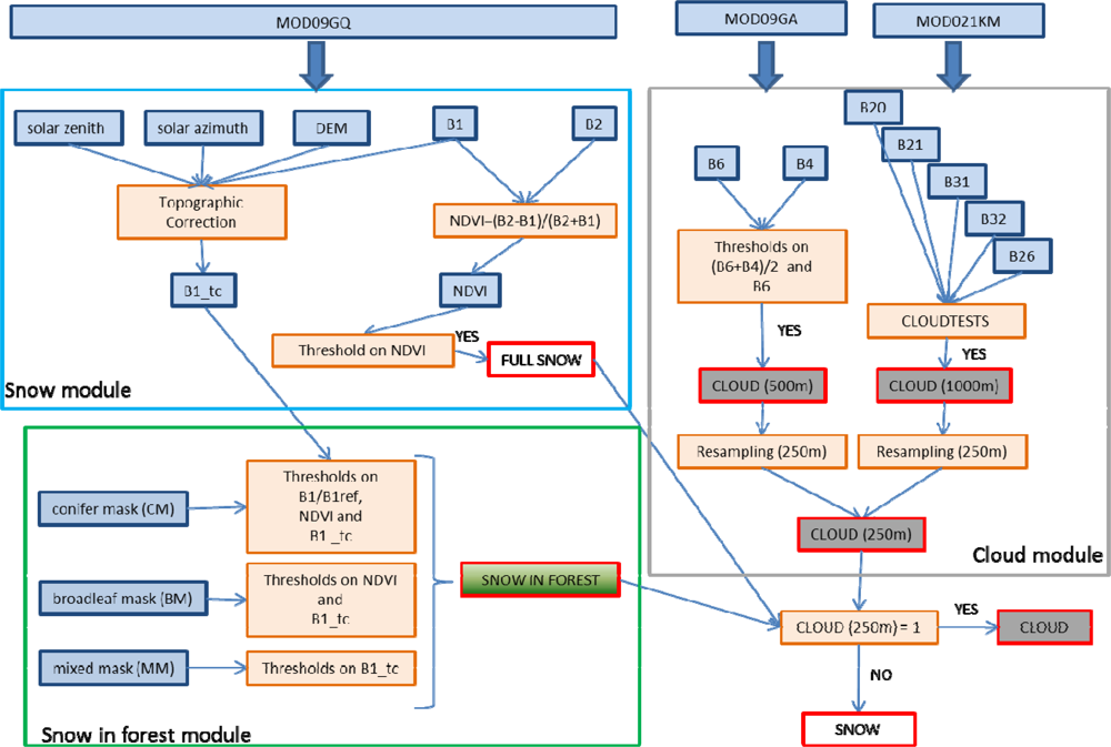
3.1. Preprocessing of MODIS Data
- - after the correction, the areas “in light” and those “in shadow” should have the same mean radiance;
- - the corrected radiance of areas in the correct sun illumination should remain equal to non-corrected radiance.
- cos θz = IL no topographic correction is required;
- cos θz > IL areas in shadows;
- cos θz < IL areas in light.
3.2. Snow Module
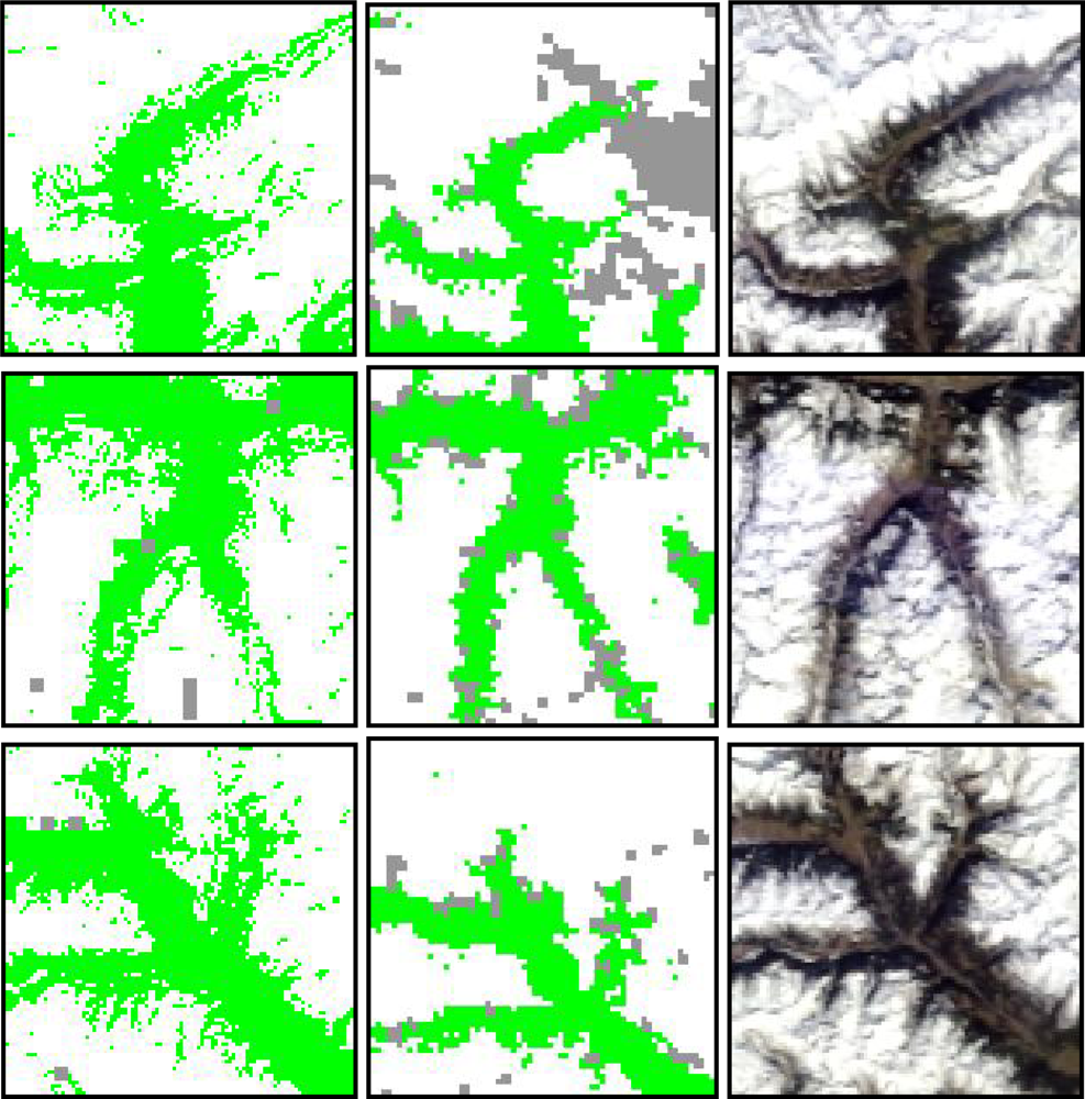
3.3. Snow Detection in Forest Module
Conifer:
- - B1 reflectance tc (topographically correct) values higher than 0.10–0.15 indicates the presence of snow due to the high value of snow reflectance even if mixed with forest reflectance;
- - B1/B1ref indicates a difference with respect to the summer image in order to avoid misclassification in the evaluation of B1 reflectance due to problem of mixed pixels and the contribution of tree reflectance. Ratio values higher than 1.2–1.4 may indicate the presence of snow.
Broadleaf:
Mixed:
3.4. Cloud Module
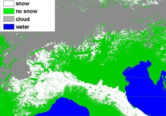
3.5. Merging Aqua and Terra SCA Maps
3.6. Product Delivery Information
- - single SCA map (indicated as IM) based on MODIS Terra or Aqua images on the area where the acquisitions are available;
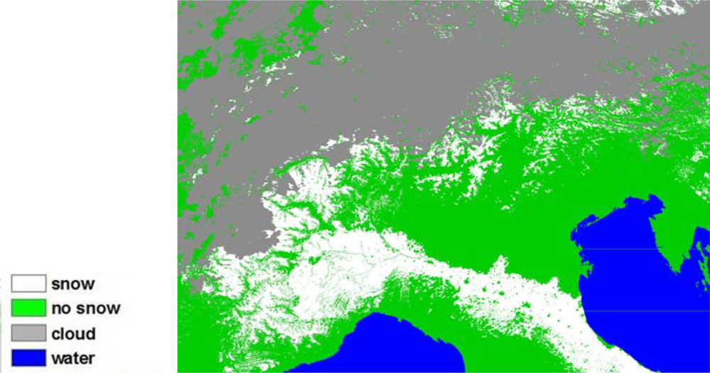
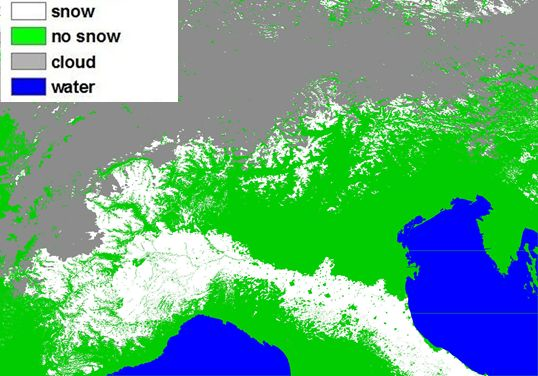
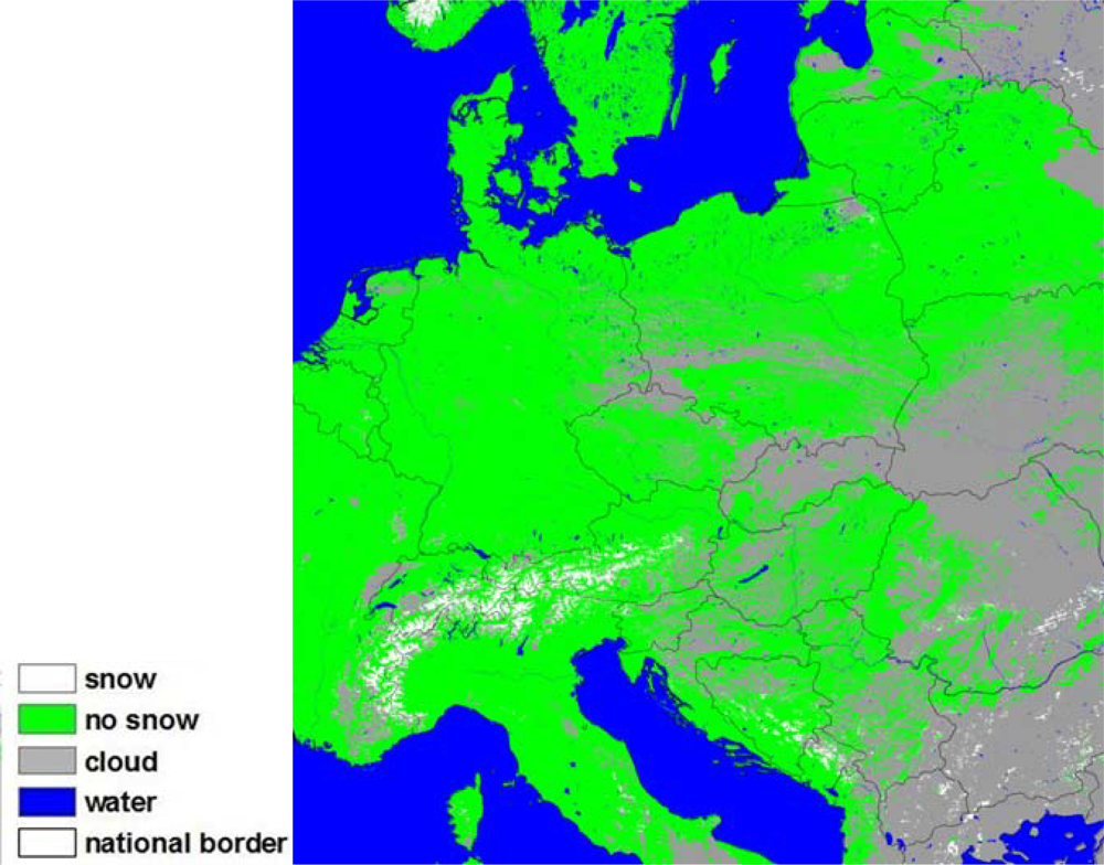
- - enhanced SCA maps (indicated as CM) based on a combination of snow maps derived from MODIS Terra and Aqua acquisitions on the area where the acquisitions are available, thus reducing both cloud and “no data”-pixel. To obtain a complete coverage of the area of interest, a single pass is sometimes enough, while in other cases, two consecutive passes from the same satellite are required. Examples of these two cases are respectively shown in Figure 5 for the Terra satellite.
4. SCA Maps Quality Indices
- 0: missing data;
- 1: low quality;
- 2: medium quality;
- 3: high quality.
- - In the case that both the standard NDSI indicates a high snow probability (NDSI > 0.7) and the proposed SCA have also detected snow, the data are flagged as high quality.
- - In the case that the NDSI maps indicate a medium snow probability (0.4 < NDSI < 0.7) and the proposed SCA maps detect snow, the data are flagged as medium quality.
- - In the case that the NDSI values indicate low probability of snow (NDSI < 0.4) and the proposed SCA maps detect snow, these pixels are flagged as low quality.
- - Cloudy pixels set to “HIGH” have a probability value in the cloud mask higher than 95%.
- - Cloudy pixels set to “MEDIUM” have a probability value in the cloud mask between 95% and 68%.
- - Cloudy pixels set to “LOW” have a probability value in the cloud mask lower than 68%.
- - High quality when the solar zenith is less than 85.0° and sensor zenith is less than 60°;
- - medium quality when the solar zenith is either greater than 85.0° or sensor zenith is greater than 60°;
- - low quality when the solar zenith is greater than 85.0° and sensor zenith is greater than 60°.
5. Results
- - The proposed algorithm determines from 200 to 310 available SCA maps;
- - MODIS algorithm produces from 150 to 280 available SCA maps.
6. Conclusions
References
- Roy, A.; Royer, A.; Turcotte, R. Improvement of springtime stream-flow simulations in a boreal environment by incorporating snow-covered area derived from remote sensing data. J. Hydrol 2010, 390, 35–44. [Google Scholar]
- Dozier, J.; Painter, T.H. Multispectral and hyperspectral remote sensing of alpine snow properties. Ann. Rev. Earth Planet. Sci 2004, 32, 465–494. [Google Scholar]
- Hall, D.K.; Riggs, G.; Salomonson, V.V.; DiGirolamo, N.E.; Bayr, K.J. MODIS snow-cover products. Remote Sens. Environ 2002, 83, 181–194. [Google Scholar]
- Clark, M.P.; Slater, A.G.; Barrett, A.P.; Hay, L.E.; McCabe, G.J.; Rajagopalan, B.; Leavesley, G.H. Assimilation of snow covered area information into hydrologic and land-surface models. Adv. Water Resour 2006, 29, 1209–1221. [Google Scholar]
- Tekeli, A.E.; Akyürek, Z.; Şorman, A.A.; Şensoy, A.; Şorman, A.Ü. Using MODIS snow cover maps in modeling snowmelt runoff process in the eastern part of Turkey. Remote Sens. Environ 2005, 97, 216–230. [Google Scholar]
- Dietz, A.J.; Wohner, C.; Kuenzer, C. European snow cover characteristics between 2000 and 2011 derived from improved MODIS daily snow cover products. Remote Sens 2012, 4, 2432–2454. [Google Scholar]
- Wang, X.; Xie, H.; Liang, T. Evaluation of MODIS snow cover and cloud mask and its application in Northern Xinjiang, China. Remote Sens. Environ 2008, 112, 1497–1513. [Google Scholar]
- Hall, D.K.; Riggs, G.A. Accuracy assessment of the MODIS snow-cover products. Hydrol. Process 2007, 21, 1534–1547. [Google Scholar]
- Klein, A.G.; Barnett, A. Validation of daily MODIS snow maps of the Upper Rio Grande River Basin for the 2000–2001 snow year. Remote Sens. Environ 2003, 86, 162–176. [Google Scholar]
- Liang, T.G.; Huang, X.D.; Wu, C.X.; Liu, X.Y.; Li, W.L.; Guo, Z.G. An application of MODIS data to snow cover monitoring in a pastoral area: A case study in Northern Xinjiang, China. Remote Sens. Environ 2008, 112, 514–1526. [Google Scholar]
- Maurer, E.P.; Rhoads, J.D.; Dubayah, R.O.; Lettenmaier, D.P. Evaluation of the snow covered area data product from MODIS. Hydrol. Process 2003, 17, 59–71. [Google Scholar]
- Zhou, X.; Xie, H.; Hendrickx, M.H.J. Statistical evaluation of remotely sensed snow-cover products with constraints from streamflow and SNOTEL measurements. Remote Sens. Environ 2005, 94, 214–231. [Google Scholar]
- Metsämäki, S.; Vepsäläinen, J.; Pulliainen, J.; Sucksdorff, Y. Improved linear interpolation method for the estimation of snow-covered area from optical data. Remote Sens. Environ 2002, 82, 64–78. [Google Scholar]
- Malcher, P.; Floricioiu, D.; Rott, H. Snow Mapping in Alpine Areas Using Medium Resolution Spectrometric Sensors. Proceedings of IEEE International Geoscience and Remote Sensing Symposium, Toulouse, France, 21–25 July 2003; 4, pp. 2835–2837.
- Warren, S.G. Optical properties of snow. Rev. Geophys. Space Phys 1982, 20, 67–89. [Google Scholar]
- Sirguey, P.; Mathieu, R.; Arnaud, Y. Subpixel monitoring of the seasonal snow cover with MODIS at 250 m spatial resolution in the Southern Alps of New Zealand: Methodology and accuracy assessment. Remote Sens. Environ 2009, 113, 160–181. [Google Scholar]
- Salomonson, V.V.; Appel, I. Development of the Aqua MODIS NDSI fractional snow cover algorithm and validation results. IEEE Trans. Geosci. Remote Sens 2006, 44, 1747–1756. [Google Scholar]
- Parajka, J.; Blöschl, G. MODIS-Based Snow Cover Products, Validation, and Hydrologic Applications. In Multiscale Hydrologic Remote Sensing Perspectives and Applications; Chang, N.-B., Hong, Y., Eds.; CRC Press: Boca Raton, FL, USA, 2012; pp. 185–212. [Google Scholar]
- Vikhamar, D.; Solberg, R. Snow-cover mapping in forests by constrained linear spectral unmixing of MODIS data. Remote Sens. Environ 2003, 88, 309–323. [Google Scholar]
- Painter, T.H.; Rittger, K.; McKenzie, C.; Slaughter, P.; Davis, R.E.; Dozier, J. Retrieval of subpixel snow covered area, grain size and albedo from MODIS. Remote Sens. Environ 2009, 113, 868–879. [Google Scholar]
- Rittger, K.; Painter, T.H.; Dozier, J. Assessment of methods for mapping snow cover from MODIS. Adv. Water Resour. 2012; in press. [Google Scholar]
- GCOS. Systematic Observation Requirements for Satellite-Based Data Products for Climate 2011 Update: Supplemental Details to the Satellite-Based Component of the “Implementation Plan for the Global Observing System for Climate in Support of the UNFCCC (2010 Update); WMO: Geneva, Switzerland, 2011; Available online: http://www.wmo.int/pages/prog/gcos/Publications/gcos-154.pdf (accessed on 15 December 2012).
- Notarnicola, C.; Duguay, M.; Moelg, N.; Schellenberger, T.; Tetzlaff, A.; Monsorno, R.; Costa, A.; Steurer, C.; Zebisch, M. Snow cover maps from MODIS images at 250m resolution, Part 2: validation. Remote Sens 2012. submitted.. [Google Scholar]
- MODIS Surface Reflectance User’s Guide, Version 1.3;; February 2011. Available online: http://modis-sr.ltdri.org/ (accessed on 15 December 2012).
- Civco, D.L. Topographic normalization of Landsat Thematic Mapper digital imagery. Photogramm. Eng. Remote Sensing 1980, 46, 1191–1200. [Google Scholar]
- Crane, R.G.; Anderson, M.R. Satellite discrimination of snow/cloud surfaces. Int. J. Remote Sens 1984, 5, 213–223. [Google Scholar]
- Dozier, J. Spectral signature of alpine snow cover from the Landsat thematic mapper. Remote Sens. Environ 1989, 28, 9–22. [Google Scholar]
- Lopez, P.; Sirguey, P.; Arnaud, Y.; Pouyaud, B.; Chevallier, P. Snow cover monitoring in the Northern Patagonia ice field using MODIS satellite images (2000–2006). Glob. Planet Change 2008, 61, 103–116. [Google Scholar]
- Klein, A.G.; Hall, D.K.; Riggs, G.A. Improving snow-cover mapping in forests through the use of a canopy reflectance model. Hydrol. Process 1998, 12, 1723–1744. [Google Scholar]
- Russow, W.B.; Garder, L.C. Validation of ISCCP cloud detection. J. Climate 1993, 6, 2370–2393. [Google Scholar]
- Ackerman, S.; Strabala, K.; Menzel, P.; Frey, R.; Moeller, C.; Gumley, L.; Baum, B.; Seemann, S.W.; Zhang, H. Discriminating Clear-Sky from Cloud with MODIS Algorithm Theoretical Basis Document (MOD35), MODIS Cloud Mask Team Version 5.0. October 2006.
- Cappelluti, G.; Morea, A.; Notarnicola, C.; Posa, F. Automatic detection of local cloud systems from MODIS data. J. Appl. Meteorol. Climatol 2006, 45, 1056–1072. [Google Scholar]
- Gafurov, A.; Bárdossy, A. Cloud removal methodology from MODIS snow cover product. Hydrol. Earth Syst. Sci 2009, 13, 1361–1373. [Google Scholar]
- Parajka, J.; Blöschl, G. Spatio-temporal combination of MODIS images—Potential for snow cover mapping. Water Resour. Res 2008, 44, W03406. [Google Scholar]
- Rastner, P.; Irsara, L.; Schellenberger, T.; Della Chiesa, S.; Bertoldi, G.; Endrizzi, S.; Notarnicola, C.; Steurer, C.; Zebisch, M. Snow Cover Monitoring and Modelling in the Alps Using Multi Temporal MODIS Data. Proceedings of the International Snow Science Workshop, Davos, Switzerland, 27 September–2 October 2009.
- Wang, X.; Xie, H. New methods for studying the spatiotemporal variation of snowcover based on combination products of MODIS Terra and Aqua. J. Hydrol 2009, 371, 192–200. [Google Scholar]
- Thirrel, G.; Notarnicola, C.; Kalas, M.; Zebisch, M.; Schellenberger, T.; Tetzlaff, A.; Duguay, M.; Mölg, N.; Burek, P.; de Roo, A. Assessing the quality of a real-time snow cover area product for hydrological applications. Remote Sens. Environ 2012, 127, 271–287. [Google Scholar]


| Satellite | Start Time | IM Delivery Time | IM Elapsed Time | CM Delivery Time | CM Elapsed Time |
|---|---|---|---|---|---|
| Terra | 09:19 | 11:01 | 01:41 | ||
| Terra | 10:57 | 12:58 | 02:01 | 13:07 | 02:10 |
| Aqua | 12:41 | 14:48 | 02:07 | 14:58 | 02:17 |
Share and Cite
Notarnicola, C.; Duguay, M.; Moelg, N.; Schellenberger, T.; Tetzlaff, A.; Monsorno, R.; Costa, A.; Steurer, C.; Zebisch, M. Snow Cover Maps from MODIS Images at 250 m Resolution, Part 1: Algorithm Description. Remote Sens. 2013, 5, 110-126. https://doi.org/10.3390/rs5010110
Notarnicola C, Duguay M, Moelg N, Schellenberger T, Tetzlaff A, Monsorno R, Costa A, Steurer C, Zebisch M. Snow Cover Maps from MODIS Images at 250 m Resolution, Part 1: Algorithm Description. Remote Sensing. 2013; 5(1):110-126. https://doi.org/10.3390/rs5010110
Chicago/Turabian StyleNotarnicola, Claudia, Martial Duguay, Nico Moelg, Thomas Schellenberger, Anke Tetzlaff, Roberto Monsorno, Armin Costa, Christian Steurer, and Marc Zebisch. 2013. "Snow Cover Maps from MODIS Images at 250 m Resolution, Part 1: Algorithm Description" Remote Sensing 5, no. 1: 110-126. https://doi.org/10.3390/rs5010110
APA StyleNotarnicola, C., Duguay, M., Moelg, N., Schellenberger, T., Tetzlaff, A., Monsorno, R., Costa, A., Steurer, C., & Zebisch, M. (2013). Snow Cover Maps from MODIS Images at 250 m Resolution, Part 1: Algorithm Description. Remote Sensing, 5(1), 110-126. https://doi.org/10.3390/rs5010110