Estimating Coastal Lagoon Tidal Flooding and Repletion with Multidate ASTER Thermal Imagery

Abstract
:
1. Introduction
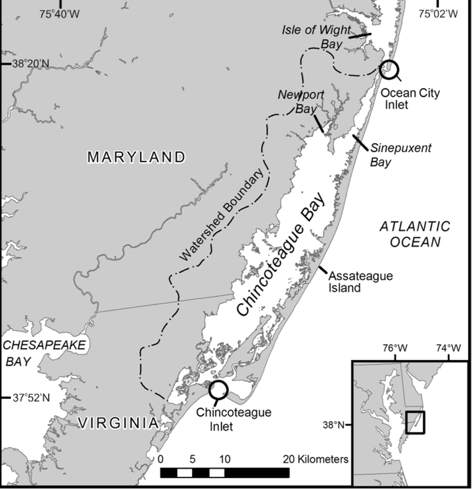
2. Study Area
3. Methodology
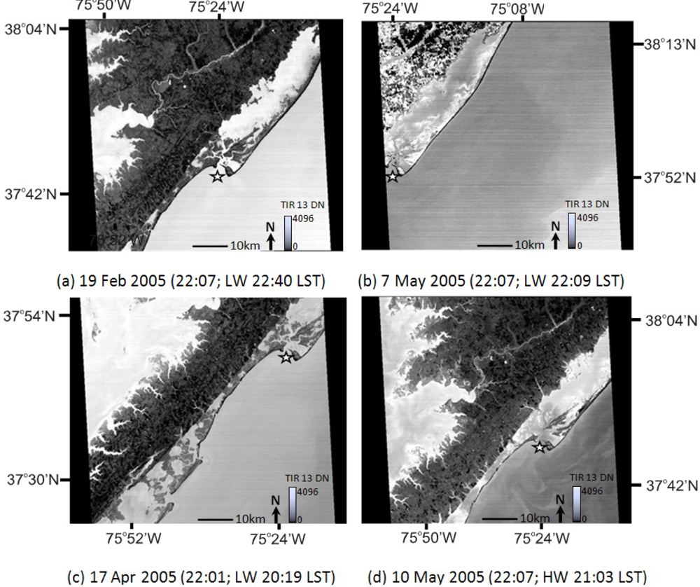
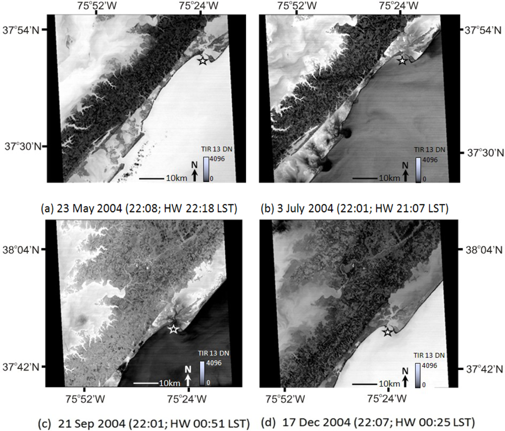
3.1. ASTER Quicklook Image Analysis
3.2. ASTER TIR Data and Surface Temperature
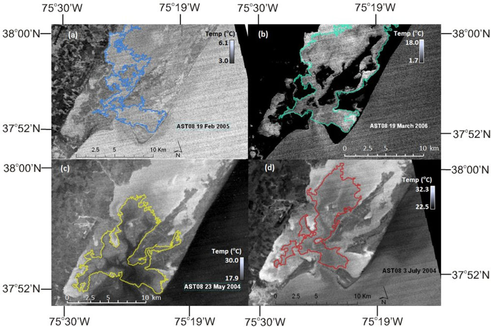
3.3. Tidal Repletion Footprint Delineation and Variability
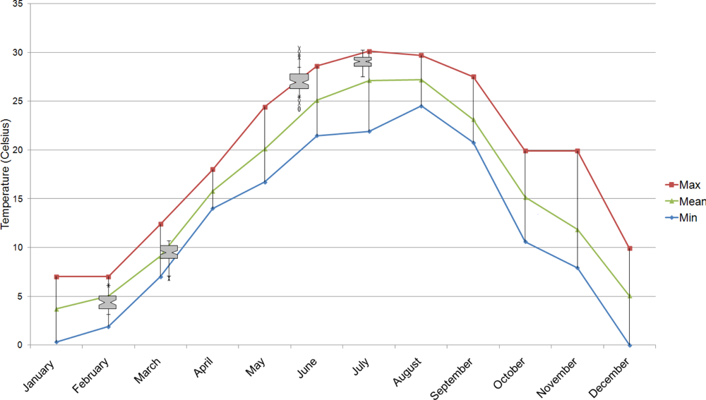
4. Results and Discussion
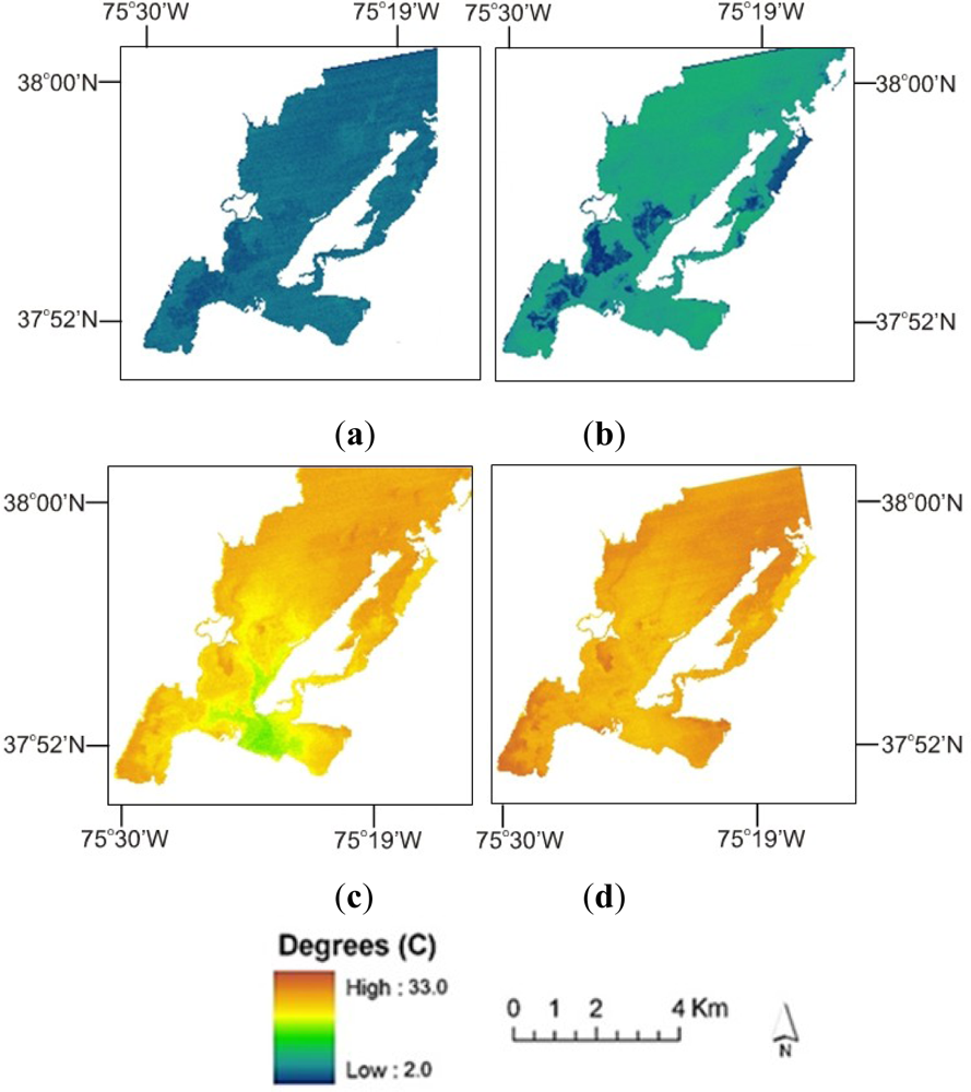
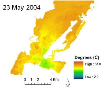
4.1. ASTER TIR Image Results
4.2. Flood Tide Repletion Zones
4.3. Spatial Zonation and Variation
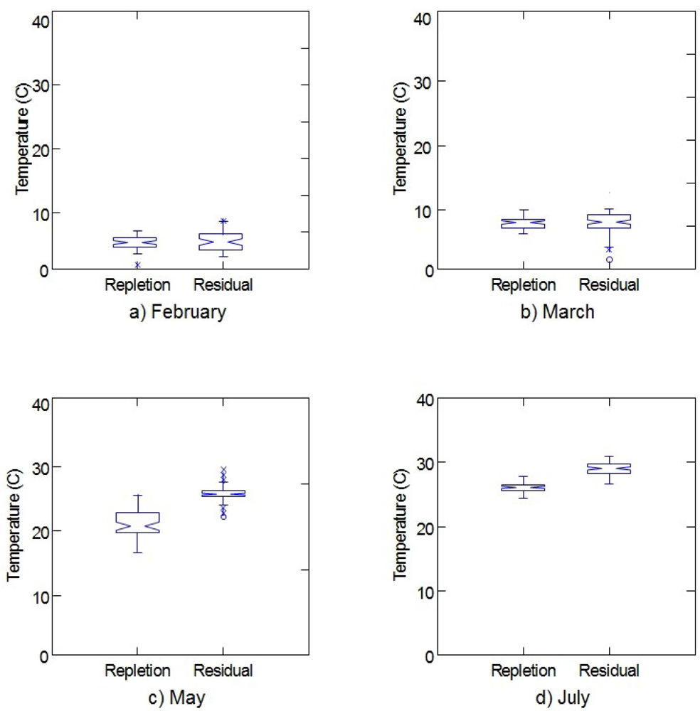
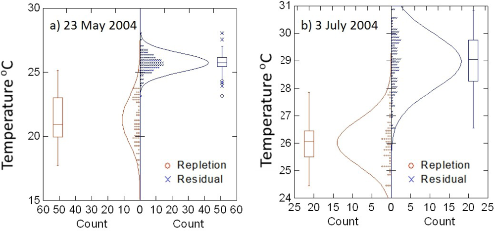
4.3.1. Verification with in situ Observations
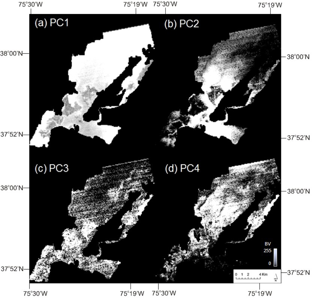
4.3.2 Zonation and Principal Components Analysis
4.4. Discussion
5. Conclusions
Acknowledgments
References
- Kjerfve, B.J.; Magill, K.E. Geographic and hydrodynamic characteristics of a shallow coastal lagoon. Mar. Geology 1989, 88, 187–199. [Google Scholar]
- Boone, J.D.; Byrne, R.J. On basin hypsometry and morphodynamic response of coastal inlet systems. Mar. Geology 1981, 40, 27–48. [Google Scholar]
- Eiser, W.C.; Kjerfve, B.J. Marsh topography and hypsometric characteristics of a shallow coastal lagoon. Mar. Geology 1986, 88, 187–199. [Google Scholar]
- Oertel, G.F. Hypsographic, hydro-hypsographic and hydrological analysis of coastal bay environments, Great Machipongo Bay, Virginia. J. Coastal Res 2001, 17, 775–783. [Google Scholar]
- Oertel, G.F.; Overman, K.; Carlson, R.; Porter, J.H.; Allen, T.R. Hypsographic Analysis of Coastal Bay Environments Using Integrated Remote Sensing Techniques, Great Machipongo Bay, Virginia. Proceedings of 6th International Conference Remote Sensing for Marine and Coastal Environments, Charleston, SC, USA, 1–3 May 2001; pp. 269–276.
- Takeoka, H. Fundamental concepts of exchange and transport time scales in a coastal sea. Cont. Shelf Res 1984, 3, 311–326. [Google Scholar]
- Matthews, J. Stereo observation of lakes and coastal zones using ASTER imagery. Remote Sens. Environ 2005, 99, 16–30. [Google Scholar]
- Ferrier, G.; Macklin, J.T.; Neill, S.P.; Folkard, A.M.; Copeland, G.J.M.; Anderson, J.M. Observing estuarine currents and fronts in the Tay Estuary, Scotland, using an airborne SAR with Along-Track Interferometry (ATI). Int. J. Rem. Sens 2005, 26, 4399–4404. [Google Scholar]
- Gillespie, A.; Rokugawa, S.; Matsunaga, T.; Cothern, J.S.; Hook, S.; Kahle, A.B. A temperature and emissivity separation algorithm for advanced spaceborne thermal emission and reflection radiometer (ASTER) images. IEEE Trans. Geosci. Remote Sens 1998, 36, 1113–1126. [Google Scholar]
- Trunk, L.; Bernard, C.A. Investigating crater lake warming using ASTER thermal imagery: Case studies at Ruapehu, Poás, Kawah Ijen, and CopahuéVolcanoes. J. Volcanol. Geothermal Res 2008, 178, 259–270. [Google Scholar]
- Dinnel, S.P.; Schroeder, W.W.; Wiseman, W.J., Jr. Estuarine-shelf exchange using Landsat images of discharge plumes. J. Coastal Res 1990, 6, 789–799. [Google Scholar]
- Thomas, A.; Byrne, D.; Weatherbee, R. Coastal sea surface temperature variability from Landsat infrared data. Remote Sens. Environ 2002, 81, 262–272. [Google Scholar]
- Fisher, J.I.; Mustard, J.F. High spatial resolution sea surface climatology from Landsat thermal infrared data. Remote Sens. Environ 2004, 90, 293–307. [Google Scholar]
- Handcock, R.N.; Gillespie, A.R.; Cherkauer, K.A.; Kay, J.E.; Burges, S.J.; Kampf, S.K. Accuracy and uncertainty of thermal-infrared remote sensing of stream temperatures at multiple spatial scales. Remote Sens. Environ 2006, 100, 427–440. [Google Scholar]
- Laymon, C.A.; Quattrochi, D.A. Estimating Spatially Distributed Surface Fluxes in a Semi-Arid Great Basin Desert Using Landsat TM Thermal Data. In Thermal Remote Sensing in Land Surface Processes; Quattrochi, D.A., Luval, J.C., Eds.; CRC Press: Boca Raton, FL, USA, 2004; pp. 133–159. [Google Scholar]
- Miliaresis, G.; Partsinevelos, P. Terrain segmentation of Egypt from multi-temporal night LST imagery and elevation data. Remote Sens 2010, 2, 2083–2096. [Google Scholar]
- Environmental Protection Agency (EPA), Delmarva’s Coastal Bay Watersheds: Not up the Creek Yet; Report R-96/052; EPA Office of Research and Development, US EPA: Ocean City, MD, USA, 1996.
- Wazniak, C.; Hall, M.; Cain, C.; Wilson, D.; Jesien, R.; Thomas, J.; Carruthers, C.; Dennison, W. State of the Maryland Coastal Bays. 2004. Available online: http://www.mdcoastalbays.org/archive/2004/MCB-State-Bay-2004.pdf (accessed on 17 August 2005).
- Bricker, S.B.; Clement, C.G.; Pirhalla, D.E.; Orlando, S.P.; Farrow, D.R.G. National Estuarine Eutrophication Assessment: Effects of Nutrient Enrichment in the Nation’s Estuaries; National Ocean Service, Special Projects Office and the National Centers for Coastal Ocean Science: Silver Spring, MD, USA, 1999. [Google Scholar]
- Bricker, S.B.; Longstaff, B.; Dennison, W.; Jones, A.; Boicourt, K.; Wicks, C.; Woerner, J. Effects of Nutrient Enrichment in the Nation’s Estuaries: A Decade of Change (National Estuarine Eutrophication Update); National Ocean Service, National Centers for Coastal Ocean Science: Silver Spring, MD, USA, 2007. [Google Scholar]
- National Aeronautics and Space Administration, ASTER Higher-Level Product User Guide, Version 2.0; Report JPL D-20062; NASA Jet Propulsion Laboratory, California Institute of Technology: Pasadena, CA, USA, 2001; p. 80.
- Hook, S.J.; Myers, J.J.; Thome, K.J.; Fitzgerald, M.; Kahle, M.B. The MODIS/ASTER airborne simulator (MASTER)—A new instrument for earth science studies. Remote Sens. Environ 2001, 76, 93–102. [Google Scholar]
- Jimenez-Munoz, J.C.; Sobrino, J.A. Feasibility of retrieving land-surface temperature from ASTER TIR bands using two-channel algorithms: A case study of agricultural areas. IEEE Geosci. Remote Sens. Lett 2007, 4, 460–464. [Google Scholar]
- NASA. Landsat 7 Science Data Users Handbook. Available online: http://landsathandbook.gsfc.nasa.gov/pdfs/Landsat7_Handbook.pdf (accessed on 14 September 2012).
- NASA. Landsat Data Continuity Mission (LDCM). Available online: http://www.nasa.gov/mission_pages/landsat/spacecraft/index.html (accessed on 14 September 2012).


| Image Date | Image Acquisition (LST) | Tide (LST) | Image-Tidal Stage Offset (min) | Note |
|---|---|---|---|---|
| 19 February 2005 | 22:07 | Low 22:40 | −33.0 | Nearest mean low water (MLW) |
| 19 March 2006 | 22:01 | High 22:27 | −26.0 | Near high water |
| 23 May 2004 | 22:08 | High 23:16 | −68.0 | Near high water |
| 3 July 2004 | 22:01 | High 22:07 | −6.0 | Nearest mean high water (MHW) |
| Image Date | Seed Pixel Temperature (°C) | Euclidean Threshold (°C) | Scene Temperature Range (°C) |
|---|---|---|---|
| 19 February 2005 | 6.0 | ±0.5 | 3.3–6.1 |
| 19 March 2006 | 5.0 | ± 1.0 | 1.7–17.8 |
| 23 May 2004 | 18.9 | ± 2.5 | 17.9–30.0 |
| 3 July 2004 | 24.5 | ± 1.5 | 22.5–32.3 |
| Principal Components | ||||
| 1 | 2 | 3 | 4 | |
| Eigenvalues (variance proportion) | 15,139.80 (0.958) | 438.707 (0.028) | 131.679 (0.008) | 85.652 (0.005) |
| Eigenvectors | ||||
| 19 February 2005 | 0.419 | 0.419 | 0.804 | 0.022 |
| 19 March 2006 | 0.641 | 0.490 | −0.589 | −0.032 |
| 23 May 2004 | 0.469 | −0.544 | 0.019 | 0.694 |
| 3 July 2004 | 0.438 | −0.535 | 0.070 | −0.718 |
Share and Cite
Allen, T.R. Estimating Coastal Lagoon Tidal Flooding and Repletion with Multidate ASTER Thermal Imagery. Remote Sens. 2012, 4, 3110-3126. https://doi.org/10.3390/rs4103110
Allen TR. Estimating Coastal Lagoon Tidal Flooding and Repletion with Multidate ASTER Thermal Imagery. Remote Sensing. 2012; 4(10):3110-3126. https://doi.org/10.3390/rs4103110
Chicago/Turabian StyleAllen, Thomas R. 2012. "Estimating Coastal Lagoon Tidal Flooding and Repletion with Multidate ASTER Thermal Imagery" Remote Sensing 4, no. 10: 3110-3126. https://doi.org/10.3390/rs4103110
APA StyleAllen, T. R. (2012). Estimating Coastal Lagoon Tidal Flooding and Repletion with Multidate ASTER Thermal Imagery. Remote Sensing, 4(10), 3110-3126. https://doi.org/10.3390/rs4103110