1. Introduction
Particulate Matter (PM) of natural and anthropogenic origin dominates the health effects of air pollution, as well as affecting the energy balance of the Earth-atmosphere system. Climate and human health effects depend on the size, amount, and composition of atmospheric particles, and as a consequence,
in situ observations are usually used to determine PM mass concentrations and to characterize chemical and physical properties of sampled particles. PM sources vary over small spatial scales and the aerosol lifetime is of the order of less than an hour to several days, depending on particle size, chemical composition and atmospheric conditions. PM ground-based observations represent point measurements that are poor or even missing in many regions of the world and do not allow achieving the necessary coverage to map the regional to global distribution of PM. Satellite observations offer a much wider spatial view than
in situ observations, and several studies have shown that they have great potential for deriving worldwide indirect estimates of ground PM [
1,
2,
3]. However, satellite observations are less precise than
in situ measurements. This suggests that they may be useful to improve the insight in regional PM distributions in combination with models and
in situ measurements [
2]. The satellite derived Aerosol Optical Thickness (AOT), which is the integral of the aerosol extinction from the ground up to the top of the atmosphere, is commonly used to provide a measure of the PM abundance. In particular, AOTs derived from the Moderate Resolution Imaging Spectral Radiometer (MODIS) have been compared with measured surface PM in several studies, due to the capability of the MODIS to provide near-daily global coverage and its good spatial resolution. Seven years of MODIS AOTs and ground PM2.5 measurements were used by [
1] to present a comprehensive analysis of various aspects of PM air quality over one site in the Southeastern United States. Koelemeijer
et al. [
4] also explored the relation between MODIS AOTs and PM (both PM10 and PM2.5) for Europe. They found that linear correlation coefficients between AOTs and 24 hour-averaged PM10 and PM2.5 mass concentrations vary within the 0.15–0.35 and 0.18–0.27 range, respectively. Linear correlation coefficients varying within the 0.11–0.85 range have also been found by [
5]. They performed an inter-comparative and quantitative analysis of MODIS-AOTs and PM2.5 mass concentrations collocated in space and time, in 26 sites spread over India, Australia, Hong Kong, Switzerland, and the United States. The above mentioned studies have shown that the PM-AOT correlation depends on the region, aerosol type, aerosol vertical profile, and meteorological parameters. Therefore, empirical relations between AOT and PM10 or PM2.5 measurements which take into account meteorological parameters have also been reported in studies referring to several world sites. In particular, Koelemeijer
et al. [
4] found that the correlation between PM and AOT is improved when the AOT is divided by the mixing layer height and, to lesser extent, when it is corrected for growth of aerosol with relative humidity. On the contrary, Schaap
et al. [
6] found that the AOT to PM2.5 relationship was insensitive to the inclusion of the mixed layer height while it was quite affected by cloud-contaminated AOTs. In particular, they showed that the correlation coefficients for the AOT-PM2.5 relations increased by restricting the analysis to clear-sky days. A better understanding of the main parameters affecting the strength of the AOT-PM correlation is therefore required to further contribute to the establishment of reliable satellite estimates of PM mass concentrations.
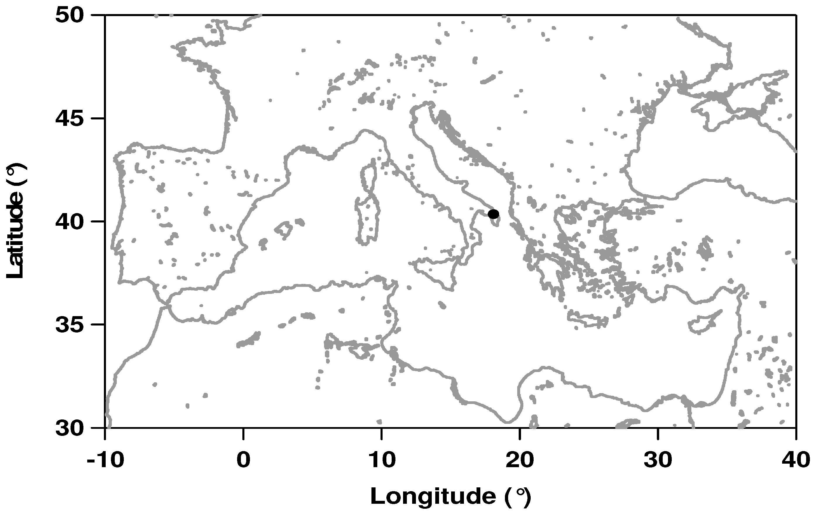
In this paper, we explore the relation between MODIS derived AOTs and 24 hour-averaged PM10 mass concentrations, since European air quality standards are at present set for 24-hour mean PM10 mass concentrations. The study is focused on a flat peninsular area in Southeastern Italy. This area is of particular importance as it is a crossroad where aerosols from different sources converge [
7,
8], such as fine anthropogenic aerosols from Europe, desert dust from North Africa and maritime aerosols from Mediterranean Sea. As a consequence, this area can be representative of many coastal areas of the central Mediterranean [
9]. We use MODIS Terra and Aqua AOTs in addition to PM10 mass concentrations of two air quality stations, to investigate cloud cover, mixing layer height, and wind speed effects on the AOT-PM10 relationship, between 2006 and 2008. In addition, measurements from the AERONET sun/sky radiometer operating on the roof of the Physics Department of Universita’ del Salento (Lecce University; 40.33°N, 18.10°E, 27 m a.s.l.), have been used to select clear sky MODIS measurements. The main statistical results on PM and AOT data are presented in
Section 2. Then, the AOT-PM relationship is analyzed in
Section 3. In addition to the MODIS cloud-cover product, the availability of sun-sky radiometer measurements performed within AERONET has been taken into account to select clear-sky MODIS-AOTs and to investigate how cloud-contaminated AOTs affect the AOT-PM relationship [
10]. Sensitivity studies on the role of mixing layer height and ground wind speed are reported in
Section 4. Summary and conclusions are in
Section 5.
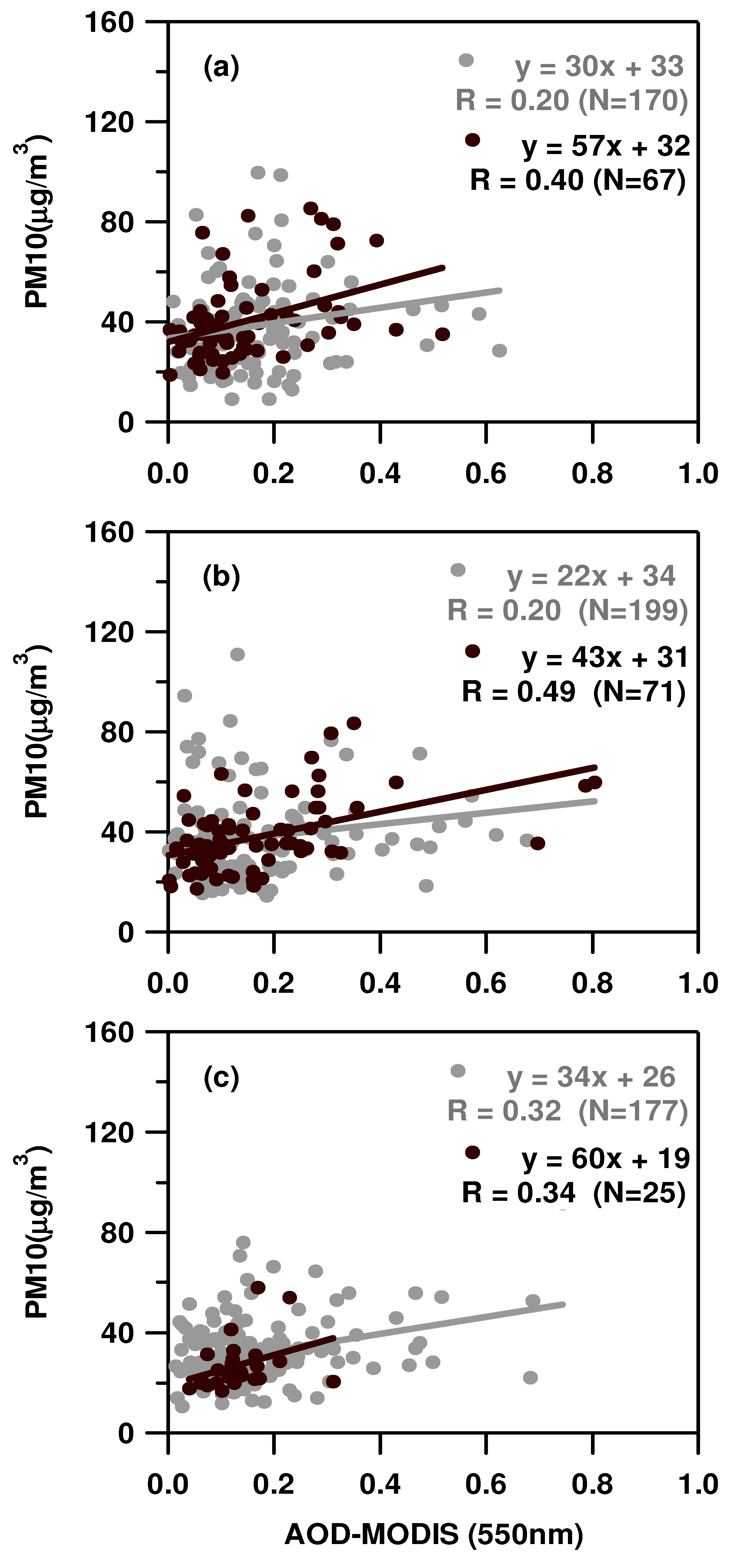
3. Results on PM10-MODIS AOT Correlations
Daily AOT means retrieved from MODIS-Terra and MODIS-Aqua measurements are plotted in this study against 24-hour averaged PM10 mass concentrations. As a first assessment of the regression relationship between AOT and PM10 mass,
Figure 5a–c and
Figure 6a–c (grey dots) show the scatterplot of PM10 mass concentrations
versus co-located in space MODIS-AOTs for Arnesano and Guagnano, respectively, for 2006, 2007, and 2008. In each plot, the grey solid lines represent the linear regression line fitting the data points. Regression line slope (
B), intercept (
C), and linear correlation coefficient (
R) are also given in each plot, in addition to the total number of data points (
N).
Figure 5 and
Figure 6 show that
B,
C, and
R values depend on the sampling year and on the monitoring site, even if the two sites considered in this study are suburban sites located 20 km apart. The AOT-PM10 regression relationship is characterized by slightly larger
B and
R values at Guagnano.
R values span the 0.20–0.32 and 0.25–0.35 range at Arnesano and Guagnano, respectively.
B values vary within the 22–34 μg/m
3 and 37–47 μg/m
3 range at Arnesano and Guagnano, respectively. Intercept values represent background PM10 mass concentrations leading to null AOT values:
i.e., the intercept represents the minimum mass concentration for which satellite derived AOT is sensitive.
C values vary within the 26–33 μg/m
3 and 20–28 μg/m
3 range at Arnesano and Guagnano, respectively.
Linear correlation coefficients of this study are in accordance with those by [
4]. They explored the relation between satellite derived AOT and PM for Europe, making use of PM mass concentrations obtained from the European AIRBASE database. In particular, they found mean
R values equal to 0.21 and 0.35 by investigating the correlation between AOTs and daily-PM10 mass concentrations at 54 background and eight rural-background stations, respectively. Engel-Cox
et al. [
25] investigated the relationship of MODIS-AOTs with ground-based particulate matter data from the United States Environmental Protection Agency (EPA) monitoring networks from April to September, 2002. They found that linear correlation coefficients of AOTs and daily-PM10 mass concentrations varied within the 0.016–0.91 range and that they were larger in the Eastern and Midwest portion of the United States.
The PM-AOT correlation depends on the study area, aerosol load and type, aerosol vertical profiles, and meteorological parameters, as several authors have outlined. However, Schaap
et al. [
2] recently showed that cloud contamination in the MODIS AOT data may significantly affect the AOT-PM correlation. At a first glance, the scatterplots of
Figure 5 and
Figure 6 (grey dots) show that several rather high AOT values are retrieved in days characterized by PM10 mass concentrations smaller than 20 μg/m
3: this could occur due to the presence of cloud-contaminated AOT values.
The MODIS algorithm initially uses radiance measurements at a resolution of 0.5 × 0.5 km
2, even if AOTs are provided at a 10 × 10 km
2 pixel resolution. All 400 pixels (20 × 20 pixels), each having resolution of 0.5 × 0.5 km
2 within the 10 × 10 km
2 area, are first examined for cloud contamination using a spatial distribution technique [
26]. The MODIS internal cloud mask at a 1 × 1 km
2 spatial resolution is also used to identify cirrus [
27]. All pixels identified as cloudy or close to clouds are removed and a further analysis uses only cloud free pixels to retrieve AOTs. However, MODIS AOTs can still be cloud contaminated, despite the rigorous cloud screening procedure used. There are two main possible sources of cloud contamination: (a) residual cirrus contamination, since cirrus screening eliminates cirrus cloud contamination above a threshold of 0.01 [
28,
29], (b) high concentration of broken cloudiness, which may generate illumination of the aerosol field beyond the 500 m distance from clouds [
30]. Therefore, the potential for contamination may increase as cloud fraction increases within the scene. The cloud fraction is defined as the fraction of the points which were rejected from the analysis by the aerosol algorithm.
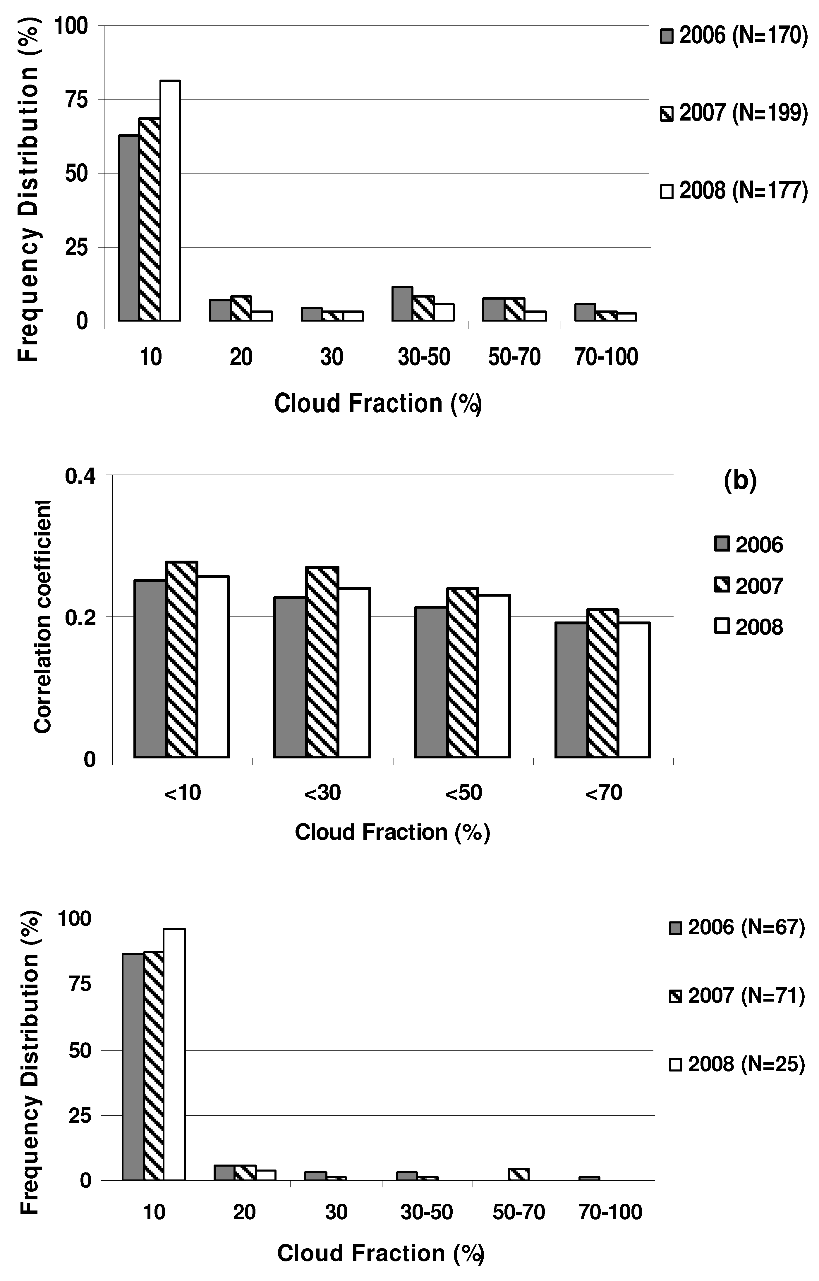
The Cloud Fraction (CF) Land product from the MODIS land only algorithm (MOD04 L2) has been used in this study to estimate, for each retrieved AOT, the fraction of rejected pixels for the presence of clouds within the 20 × 20 km
2 analyzed box. AOTs have been grouped in different CF bins and
Figure 7a shows as an example, the normalized frequency distribution histogram
versus CF bins for the AOT data set referring to Arnesano in 2006, 2007, and 2008. From
Figure 7a, we observe that 64, 70, and 82% of AOTs have been retrieved by 20 × 20 km
2 boxes with a CF smaller than 10% in 2006, 2007, and 2008, respectively. On the contrary, less than 15% of AOTs have been retrieved from boxes with a CF larger than 50%. Then, PM-AOT data points have been grouped in different CF ranges to investigate how the regression relationship between AOT and PM10 mass is affected by the CF.
Figure 7b shows, as an example, the histogram of linear correlation coefficients retrieved by taking into account Arnesano PM-AOT data points retrieved from boxes with CF <10, 30, 50, and 70%, respectively. Different bars are used to characterize
R values referring to 2006, 2007, and 2008. From
Figure 7b, it is noteworthy that the PM-AOT relationship becomes stronger when the CF decreases: correlation coefficients on average become larger as CFs decrease. These last results indicate that the PM-AOT relationship is probably affected by cloud contaminated AOTs. Results similar to those of
Figure 7b were also found at Guagnano. Gupta
et al. [
5] also found stronger PM-AOT correlations by selecting MODIS-AOTs retrieved at lower CF conditions. Conversely, Gupta
et al. [
5] found that the linear correlation coefficient decreased with CF by analyzing seven years of MODIS-AOTs and PM2.5 mass concentrations retrieved at one site in the Southeastern United States.
Figure 5.
Scatterplot of PM10 mass concentrations versus co-located in space MODIS-AOTs at Arnesano for (a) 2006, (b) 2007, and (c) 2008. Slope, intercept and linear correlation coefficient (R) are also given in each plot, in addition to the total number of data points (N). Black dots represent data points referring to clear-sky MODIS measurements.
Figure 6.
Scatterplot of PM10 mass concentrations versus co-located in space MODIS-AOTs at Guagnano for (a) 2006, (b) 2007, and (c) 2008. Slope, intercept and linear correlation coefficient (R) are also given in each plot, in addition to the total number of data points (N). Black dots represent data points referring to clear-sky MODIS measurements.
Figure 7.
(a) Normalized frequency distribution histogram versus CF bins for the PM-AOT data set of Arnesano in 2006, 2007, and 2008. (b) Histogram of linear correlation coefficients retrieved by taking into account PM-AOT data sets characterized by CF <10%, 30%, 50%, and 70%, respectively, in 2006, 2007, and 2008. (c) Normalized frequency distribution histogram versus CF calculated by considering all clear-sky MODIS measurements referring to Arnesano in 2006, 2007, and 2008. N represents the total number of used data points.
3.1. Clear-Sky MODIS Measurements According to AERONET
The availability of cloud cleared level 2 AERONET data collocated in time with Terra and Aqua overpasses is used in this study to select clear-sky MODIS AOTs, in accordance to [
6]. Particularly, AERONET measurements from the sun/sky radiometer operating on the roof of the Physics Department of Universita’ del Salento (40.33°N, 18.10°E, 27 m a.s.l.) in Lecce, which is few hundred meters away from the PM10 monitoring station of Arnesano, have been considered. AERONET is a federated international network of sun/sky radiometers established in 1993 which maintains more than 400 instruments worldwide [
31]. Data are publicly available online in near real-time mode (
http://aeronet.gsfc.nasa.gov). The CIMEL sun/sky radiometer measures direct sun radiance in eight spectral channels between 340 and 1,020 nm. An automated cloud-screening and quality control procedure is applied to AOD direct-sun measurements [
32]. The procedure consists of five parts: a data quality check, a triplet stability check, a diurnal stability check, a smoothness criteria check, and a three standard deviation criteria check [
33]. The underlying principle of both the triplet stability and smoothness criteria checks is that the temporal variation of cloud optical depth is typically greater than the one of aerosol optical depth. In the triplet stability check, three measurements, each made 30 seconds apart, are performed. Then, it is assumed that the AOD in the total atmospheric column should vary by less than 0.02 within one triplet for all wavelengths if the atmosphere is to be considered stable and cloud free. The smoothness check computes the limiting root-mean-square of the second derivative of the optical depth with time. Because the second derivative reflects the variability tendency, the root-mean-square of the second derivative of the optical depth is very sensitive to the changes of AOD caused by clouds. In general, the average second derivative increases substantially when the data are cloud contaminated. However, since temporal variations of AOT are identified as cloud contamination, it must be noted that the AERONET cloud-screening procedure will screen some cases of variable aerosol plume. Conversely, stable uniform clouds will pass the algorithm threshold and be identified as cloud free.
MODIS measurements collocated in space and time with AERONET measurements have only been taken into account to select clear-sky MODIS-AOTs and evaluate the impact of cloud contamination on the PM-AOT correlation.
Figure 5 and
Figure 6 (black dots) show the scatterplots of PM10 mass concentrations
versus clear-sky MODIS-AOTs at Arnesano and Guagnano, respectively, in 2006, 2007, and 2008. The data reported in
Figure 5 and
Figure 6 are summarized in
Table 3, and show that the PM-AOT correlation becomes stronger by taking away cloud-contaminated MODIS-AOTs. This highlights the impact of cloud contamination on the PM-AOT relationship: regression line slopes which are quite affected by the adopted cloud screening procedure increase when the analysis is restricted to clear-sky days, intercept values that are less affected decrease. Selected clear-sky MODIS-AOTs have been grouped in different CF bins. The histogram of the normalized CF frequency distribution is shown in
Figure 7c for the data set referring to Arnesano in 2006, 2007, and 2008. More than 87% of clear-sky AOTs have been retrieved from 20 × 20 km
2 boxes with a CF smaller than 10%. This last result further indicates that cloud-contaminated MODIS-AOTs can lead to weaker PM-AOT relationships.
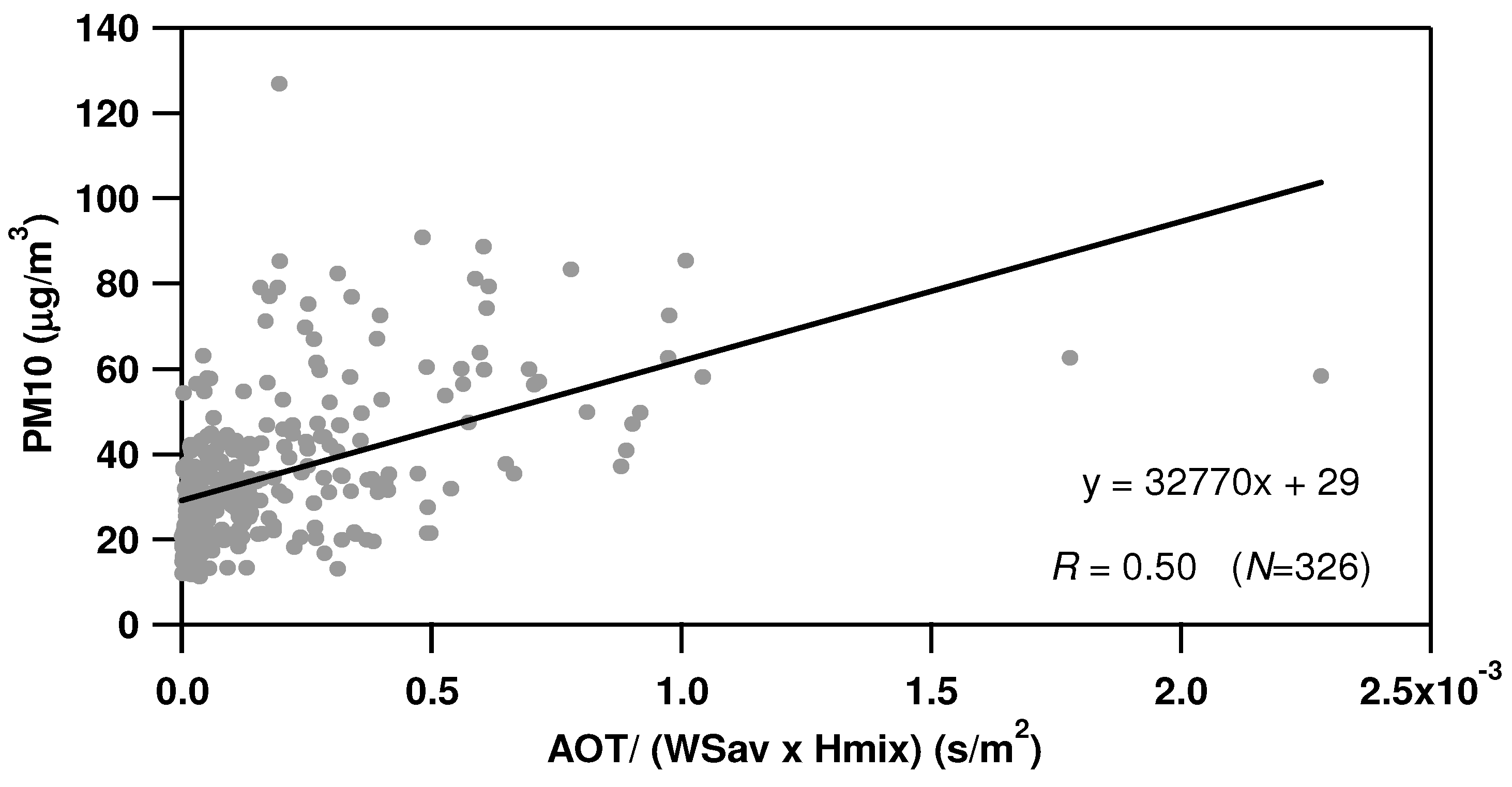
Table 3 reveals that the parameters of the PM-AOT relationship are quite sensitive to sampling year and monitoring site, even if the two sites of this study only are 20 km apart and both PM10 mass concentrations and MODIS-AOTs of the two sites are quite well correlated. However, multiyear data from different sites can allow a more general PM-AOT relationship to be achieved. The PM-AOT scatterplot (
Figure 8), obtained by taking into accounts the three-year, clear-sky PM-AOT data points of Arnesano and Guagnano, is used to retrieve a mean PM10-AOT regression relationship for suburban sites of Southeastern Italy. In
Figure 8, the solid line represents the linear regression line fitting the data points which is given by Equation (1). The linear correlation coefficient (
R = 0.46) and total number of data points (
N = 337) are also given in
Figure 8.
The average slope and intercept values given in
Table 3 leads to an equation rather similar to Equation (1).
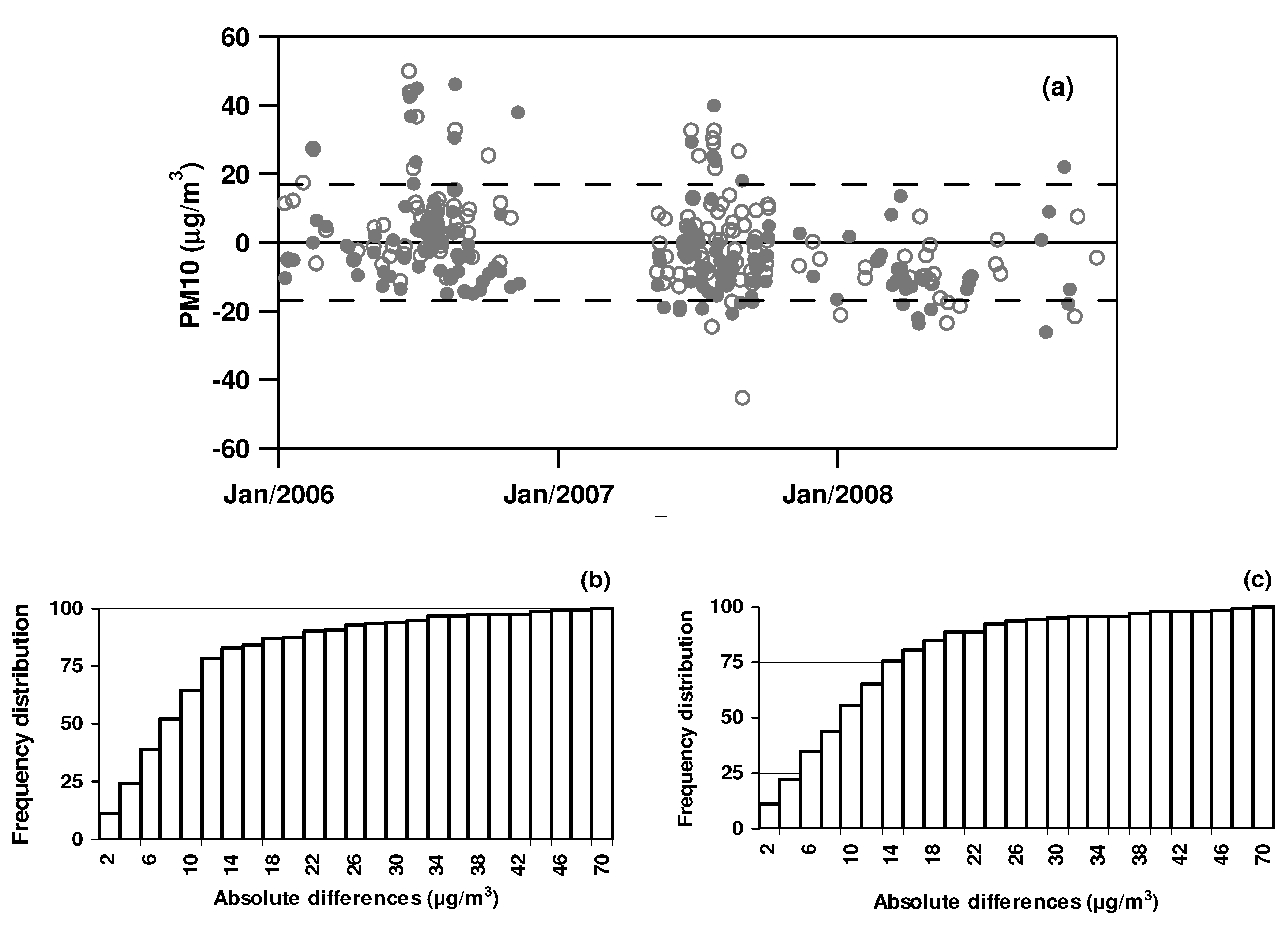
Equation (1) has been used to calculate PM10 mass concentrations at Arnesano and Guagnano in different years and to evaluate the accuracy of satellite estimated PM10 mass concentrations at the two selected sites of this study.
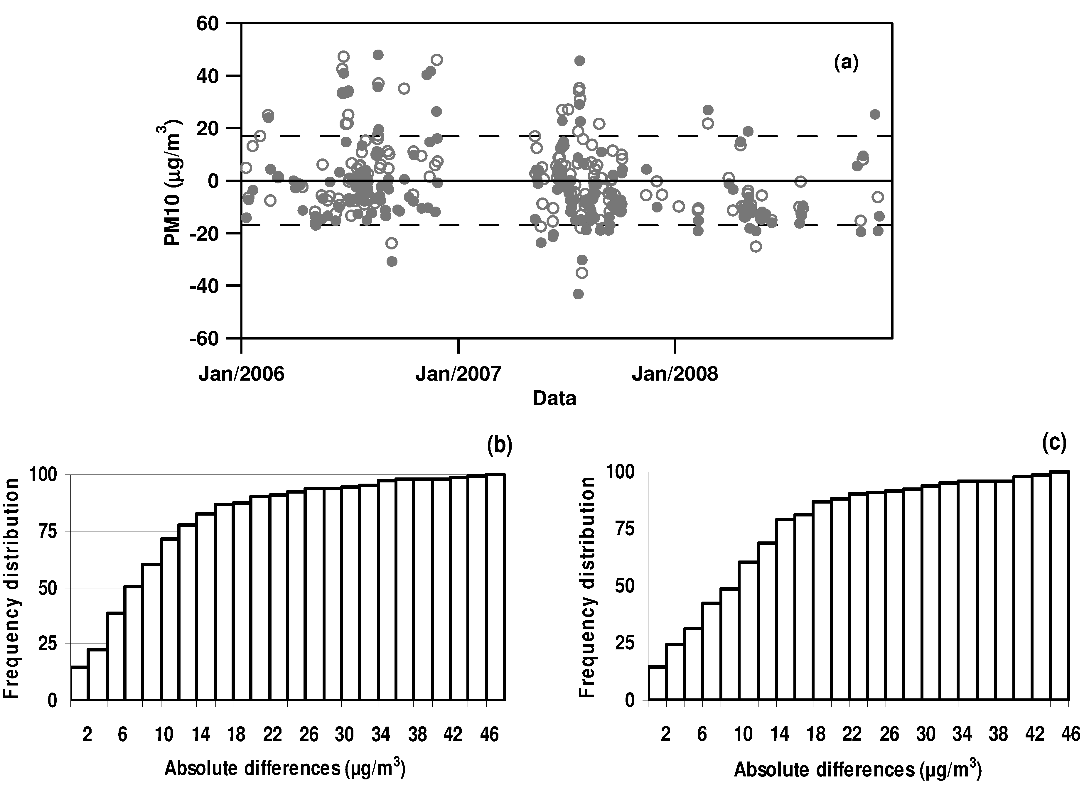
Figure 9a shows the differences between measured and estimated PM10 mass concentrations
versus time at Arnesano (open dots) and Guagnano (full dots). It is worth noting that rather few data points (37, 13, and 18, in 2006, 2007, and 2008, respectively) are, on average, available in AW months as a consequence of the larger presence of cloudy days. Dotted lines in
Figure 9a represent ±1 standard deviation of PM10 mass concentration yearly means (
Table 1). More than 80% of the differences are smaller than ±1 SD. This result is clearly revealed by
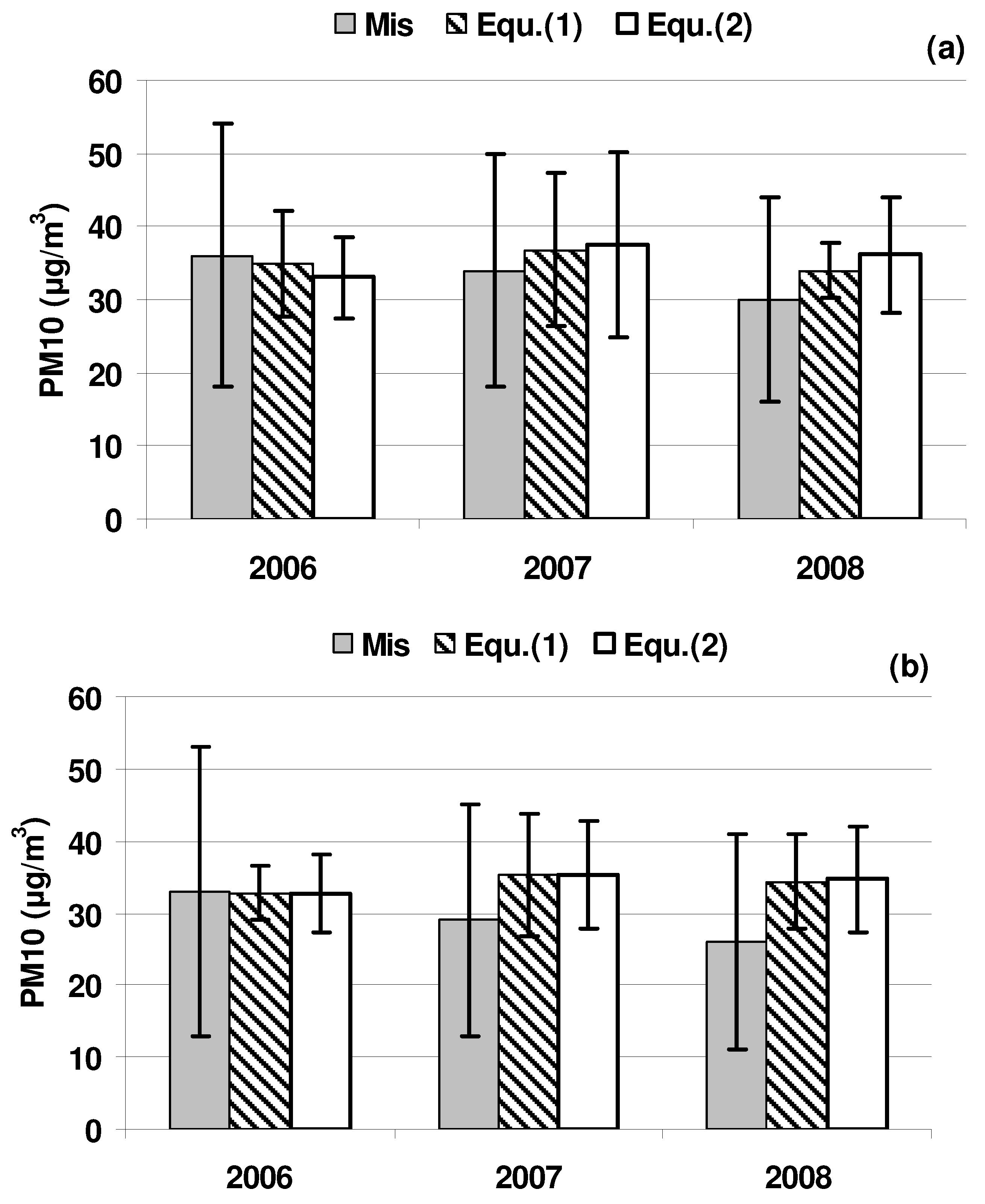
Figure 9b,c, showing the cumulative frequency distribution of absolute difference values at Arnesano and Guagnano, respectively. Yearly means ±1 SD of measured and satellite estimated PM10 mass concentrations are shown in the histogram of
Figure 10a,b for Arnesano and Guagnano, respectively. Yearly-means of PM10 mass concentrations, estimated in accordance with Equation (1), agree reasonably well with corresponding values from PM10 measurements: the difference between estimated and measured yearly means is rather small in 2006 and 2007 and are 4 μg/m
3 and 8 μg/m
3 in 2008 at Arnesano and Guagnano, respectively. The decrease of PM10 mass concentrations from 2006 to 2008, is responsible for this last result. The dependence of the PM-AOT relationship on monitoring site (
Table 3) also plays a role.
Table 3.
Slope, intercept and linear correlation coefficient of the relationship between PM10 mass concentrations and clear-sky MODIS AOTs at Arnesano and Guagnano in 2006, 2007, and 2008.
Table 3.
Slope, intercept and linear correlation coefficient of the relationship between PM10 mass concentrations and clear-sky MODIS AOTs at Arnesano and Guagnano in 2006, 2007, and 2008.
| | ARNESANO | GUAGNANO |
|---|
| | Slope | Intercept
(μg/m3) | R | Slope | Intercept
(μg/m3) | R |
|---|
| 2006 | 57 | 32 | 0.40 | 102 | 23 | 0.50 |
| 2007 | 43 | 31 | 0.49 | 69 | 20 | 0.57 |
| 2008 | 60 | 19 | 0.34 | 89 | 15 | 0.40 |
| Mean | 53 | 27 | 0.41 | 87 | 19 | 0.49 |
Figure 8.
PM-AOT scatterplot obtained by taking into accounts all clear-sky PM-AOT data points retrieved at Arnesano and Guagnano over the different years. The solid line represents the linear regression line fitting the data points. Slope, intercept, correlation coefficient (R ), and total number of data points (N ) are also given.
Figure 9.
(a) Differences between measured and estimated PM10 mass concentrations in accordance with Equation (1) at Arnesano (open dots) and Guagnano (full dots) in 2006, 2007, and 2008. Dotted lines represent ±1 SD deviation of PM10 mass concentration yearly mean values. Cumulative frequency distribution of absolute difference values at (b) Arnesano and (c) Guagnano.
Figure 10.
Yearly means ±1 SD of measured and satellite estimated PM10 mass concentrations by Equation (1) and Equation (2) at (a) Arnesano and (b) Guagnano.
Figure 10.
Yearly means ±1 SD of measured and satellite estimated PM10 mass concentrations by Equation (1) and Equation (2) at (a) Arnesano and (b) Guagnano.
Smaller differences between measured and satellite estimated PM10 mass concentrations could be obtained by using a PM10-AOT relationship more suitable for each site (
Table 3) and each year, however, the main goal of the paper was to get a more general PM10-AOT relationship for suburban sites of Southeastern Italy. AOT-PM relations reported in literature generally refer to PM2.5, since it is assumed that the coarse fraction contribute much less to the AOT than the fine fraction [
2]. Stronger PM-AOT relations have usually been found when the PM2.5 fraction is accounted for [
3]. Quite few AOT-PM10 relationships are reported in literature, even if the European air quality standard is at present set for 24-hour PM10 mass concentrations. Chu
et al. [
34] has provided some data for Northern Italy. In particular, they showed for the AERONET station at Ispra in Northern Italy, that time-series of AERONET-AOTs and 24-h average PM10 measurements correlate well (
R = 0.77), for a period of several months in 2001 with stable meteorological conditions and that the AOT-PM10 relation was: PM10 (μg/m
3) = 8 (μg/m
3) + 55 (μg/m
3) × AOT. AOTs are on average larger at Ispra than over Southeastern Italy and PM10 mass concentrations are characterized by a marked seasonal dependence with quite large (small) values in AW (SS) [
9].
5. Summary and Conclusion
24-hour averaged PM10 mass concentrations and MODIS-AOTs collocated in space have been used to explore the use of MODIS-AOTs for air quality predictions over Southeastern Italy and to contribute to the understanding of the PM10-AOT relationship since European air quality standards are now set for 24 hour PM10 mass concentrations. The study has been restricted to two suburban sites: the PM monitoring is usually less frequent or missing at suburban sites. The two sites of this study are only 20 km apart to better test the sensitivity of the PM10-AOT relationship on site location. The statistical analysis of PM10 mass concentrations has revealed a small seasonal dependence: AW-mass concentrations are slightly larger than SS mean values at both sites. The small dependence on seasons of PM10 mass concentrations is typically found over Southeastern Italy and it is probably due to the suppressed evolution with seasons of the planetary boundary layer height, as a consequence of sea breeze effects. In fact, the two selected sites are characterized by an unusual seasonal evolution of the MLH: autumn-winter MLH mean values are on average larger than spring-summer mean values. The Lagrangian HYSPLIT 4 model, widely applied in many studies for the estimation of the mixing layer height, has been used in our study. The statistical analysis of MODIS-AOTs based on Terra- and Aqua-MODIS measurements has revealed that AW-AOTs are smaller than SS-AOTs at both sites despite the seasonal dependence of PM10 mass concentrations.
A first assessment of the regression relationship between daily averaged PM10 mass concentrations and MODIS-AOTs has led to a weak PM-AOT relationship (0.20 ≤ R ≤ 0.35), partially due to the presence of cloud-contaminated AOTs: we have found that correlation coefficients on average increase as MODIS cloud fractions decrease. The cloud-screening procedure adopted within AERONET has been used to obtain a better selection of clear-sky MODIS measurements and hence stronger (0.34 ≤ R ≤ 0.57) PM-AOT relationships. Hence, the effect on the PM-AOT relationship of cloud-contaminated MODIS-AOTs has been demonstrated. The mean empirical relation we have found by taking into account three years of clear-sky data points has been used to calculate PM10 mass concentrations over different years and evaluate the accuracy of satellite estimated PM10 mass concentrations at the two suburban sites of this study. We have found that 80% of differences between measured and calculated PM10 mass concentrations are within ±1 SD of mass concentration yearly means. In particular, yearly-means of PM10 mass concentrations estimated in accordance with Equation (1) agree reasonably well with corresponding values from PM10 measurements: the differences between estimated and measured yearly means are rather small in 2006 and 2007 and equal 4 μg/m3 at Arnesano and 8 μg/m3 at Guagnano in 2008. The rather small amount of available clear-sky AOTs in 2008 and the PM10 mass concentration decrease from 2006 to 2008 are mainly responsible for the larger differences between measured and estimated PM mass concentrations found in 2008.
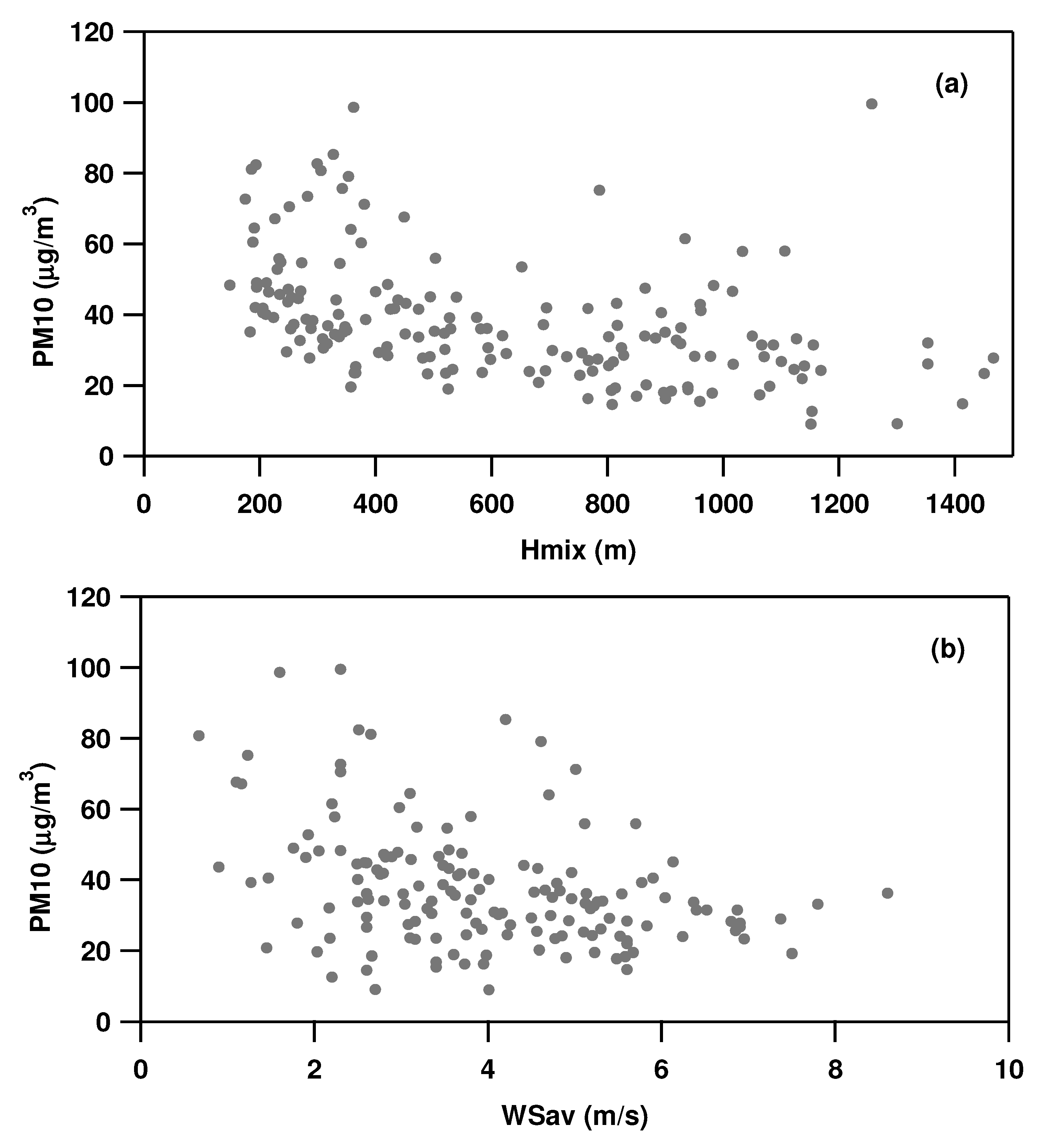
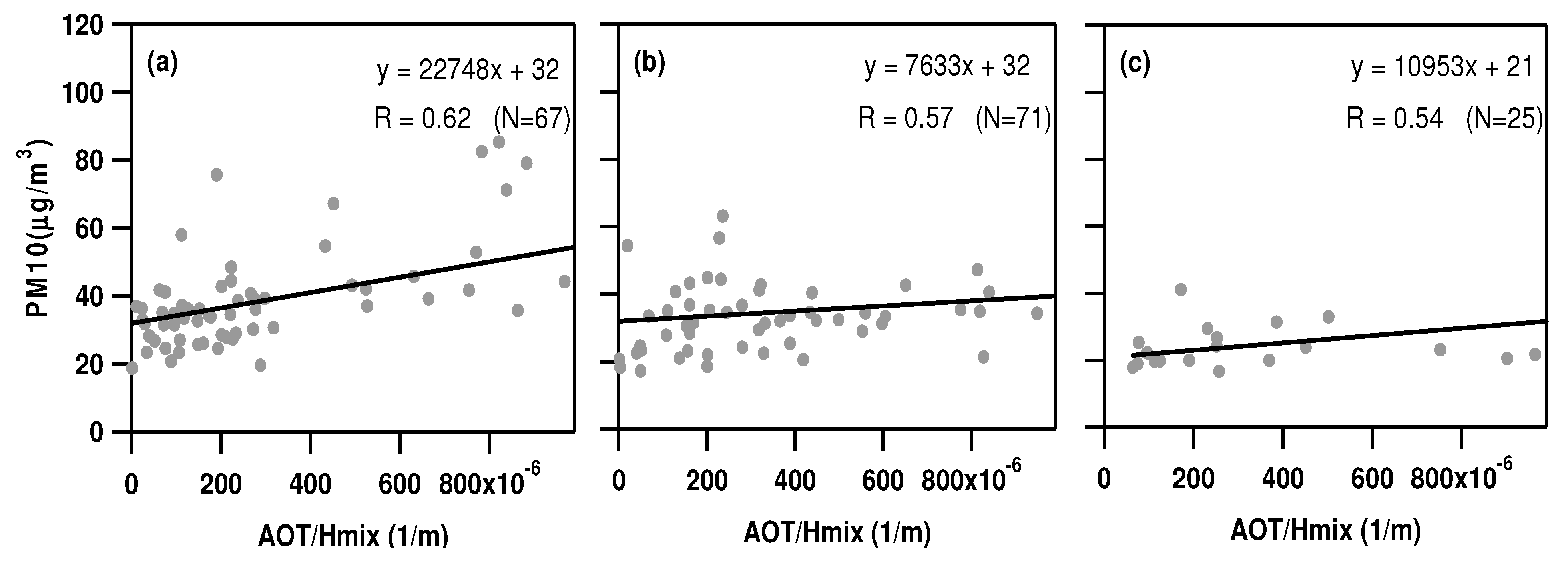
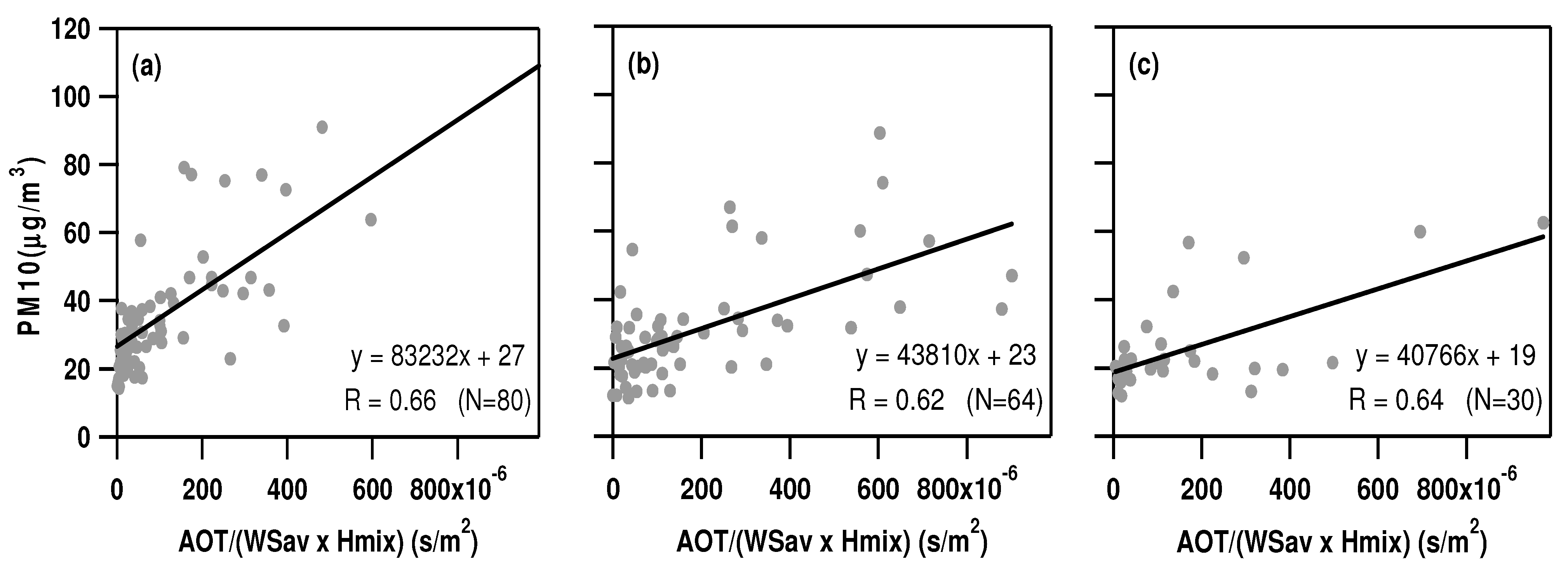
The role of the mixing layer height and ground wind-speed on the PM10-AOT relationship has also been explored. We have found that the PM-AOT relationship becomes stronger (0.52 ≤ R ≤ 0.65) when the AOT is divided by the mixing layer height and ground wind-speed. However, the empirical relationship that also accounts for mixing layer height and ground wind-speed, does not improve satellite estimated PM10 mass concentrations. The small effect on the PM-AOT relationship (small increase of correlation coefficients), when we account for mixing layer height and ground wind-speed, is probably responsible for these last results. Hence, a rather large increase of R is required to significantly improve satellite estimated PM10 mass concentrations. Several papers have also revealed that R values usually increase only a few percent when the AOT is normalized by meteorological parameters and/or factors that account for aerosol properties, in accordance with our results. Our results have also highlighted that the PM-AOT relationship for suburban sites can vary within a few tens of kilometers and can be affected by sampling year. In conclusion, our results, which are in accordance with those provided for different sites worldwide, show the potential of MODIS data for evaluating air quality in suburban sites of Southeastern Italy. We continue to investigate the effects of longer study periods on the PM-AOT relationship and to test if the empirical relation found can be applied to other suburban sites of Southeastern Italy and of the Central Mediterranean where PM10 mass concentrations and MODIS AOTs follow a seasonal trend similar to that observed in the two sites of this study.


