Article

Sensitivity Analysis of b-factor in Microwave Emission Model for Soil Moisture Retrieval: A Case Study for SMAP Mission

NOAA-Cooperative Remote Sensing Science & Technology Center (NOAA-CREST), City University of New York, NY 10031, USA
*
Author to whom correspondence should be addressed.
Remote Sens. 2010, 2(5), 1273-1286; https://doi.org/10.3390/rs2051273
Submission received: 10 February 2010 / Revised: 28 April 2010 / Accepted: 29 April 2010 / Published: 4 May 2010

Abstract

:
Sensitivity analysis is critically needed to better understand the microwave emission model for soil moisture retrieval using passive microwave remote sensing data. The vegetation b-factor along with vegetation water content and surface characteristics has significant impact in model prediction. This study evaluates the sensitivity of the b-factor, which is function of vegetation type. The analysis is carried out using Passive and Active L and S-band airborne sensor (PALS) and measured field soil moisture from Southern Great Plains experiment (SGP99). The results show that the relative sensitivity of the b-factor is 86% in wet soil condition and 88% in high vegetated condition compared to the sensitivity of the soil moisture. Apparently, the b-factor is found to be more sensitive than the vegetation water content, surface roughness and surface temperature; therefore, the effect of the b-factor is fairly large to the microwave emission in certain conditions. Understanding the dependence of the b-factor on the soil and vegetation is important in studying the soil moisture retrieval algorithm, which can lead to potential improvements in model development for the Soil Moisture Active-Passive (SMAP) mission.

Graphical Abstract

1. Introduction

Soil moisture is a very important variable in hydrology because its variations influence the evolution of weather and climate. The soil moisture controls runoff, affects vegetation growth, and plays a significant role on evaporation and transpiration at the land-atmosphere boundary as well as surface energy flux [1]. However, conducting ground-based measurements of soil moisture consistently and regionally is difficult. Remote sensing provides an opportunity without the limitation of time and area [2]. The application of remote sensing to measure soil moisture has been researched over the last thirty years using both passive and active microwave instruments [3]. Microwave remote sensing in low frequency has been optimal to estimate soil moisture since it is very sensitive to the dielectric properties of the soil [4,5]. Low frequency microwave spectrum has the advantage of longer penetration, therefore, less atmospheric effect. Two microwave satellite missions, the ESA Earth Explorer SMOS (Soil Moisture and Ocean Salinity) launched on November 2009 and SMAP (Soil Moisture Active Passive) by NASA that has been proposed to launch in 2015, take advantages of low frequency in soil moisture retrievals. SMOS mission has been designed to observe soil moisture over the global land with the first-ever polar-orbiting space-borne 2-D interferometric radiometer. This novel technique of the SMOS mission will provide operational monitoring of water in soils. SMAP mission will overlap with the SMOS mission in time so that it will enable intercalibration and intercomparison of their respective data[6]. Moreover, the synthetic aperture radar in the SMAP will provide higher spatial resolution (1–3 km) soil moisture product [7].
The soil moisture retrieval algorithms have been derived based on the microwave radiation theory and the dielectric properties of soil and vegetation [3,8,9,10]. In order to apply the soil moisture retrieval in global scale, algorithm development and validation are essential [11]. The following input data are required to perform the microwave emission model; soil temperature, soil texture, surface roughness, soil bulk density, vegetation type and vegetation water content. Because of relatively longer penetration in low frequencies, the L-band has been assumed to have lower sensitivity to the vegetation so far, and is therefore relatively transparent [3,4,8]. However, it is uncertain how low the vegetation sensitivity is and how much the vegetation affects to the emission at L-band. Therefore, the analysis of the canopy transparency which expressed in the optical depth (τ) is necessary. The optical depth is the linear relationship of the vegetation water content and the b-factor (vegetation parameter).
The b-factor is a regression coefficient that is frequency, polarization and vegetation type dependent [12]. Unlike the physical temperature and vegetation water content, the dependence of the b-factor on various physical and sensor variables cannot be determined using existing algorithms and sensor systems [13]. Consequently, the functional dependence of the b-factor on different wavelength and canopy type was investigated using published data [12]. It was shown that b-factors varied with different wavelength, suggesting that the entire wavelength range should not be described by a single function. The variation in b-factor is much smaller at L-band than at C-band, hence, it was proposed to use a single value of the b-factor regardless of vegetation cover type in the L-band range. However, a range of b-factor at L-band has been found among dominant canopy structures [14]. Therefore, further investigation of the b-factor depends on vegetation types in low frequencies are studied here by analyzing previously published data and evaluating with SGP99 experiment.
This study validates the effect of vegetation emission and verifies the importance of the b-factor sensitivity. The relative sensitivity of the b-factor is carried out through a comparison with soil moisture, vegetation water content, soil roughness and surface temperature in different soil and vegetation condition. Also, the relationship between the b-factor and different vegetation types is analyzed using field soil moisture and vegetation water content data from SGP99.

2. Study Area and Data Sets

The Southern Great Plains experiment (SGP99) was conducted during July 6th to July 20th in 1999. The goal of SGP99 was to establish and validate the retrieval algorithms for surface soil moisture developed at higher spatial resolution and extended to coarser resolutions [15]. The selected study area for this research is Little Washita watershed, located in southwest Oklahoma in the Great Plains region and covers 603 km2.
Gravimetric surface soil moisture and vegetation sampling data were used in this study. Soil moisture sampling was performed on site approximately 800 m by 800 m in size. Each site is separated by one horizontal transect and one vertical transect by 400 m. The samples were collected every 100 m being apart horizontally and vertically at the same time. These diagonal two lines lay perpendicularly resulting in 14 samples per site. Average values of each site for gravimetric soil moisture from surface to 2.5 cm deep were employed, and converted to volumetric soil moisture. The vegetation was sampled 2 to 3 per m2 for the vegetation water content measurement [2,16]. The brightness temperature data from aircraft remote sensing instrument was used in order to evaluate the potential of alternative approach to soil moisture retrieval. The Passive and Active L and S band system (PALS) was selected in this study, designed to be flown on a C-130 aircraft since it has the same frequency range (1.2–1.4 GHz) as the future Soil Moisture Active and Passive (SMAP) mission. The PALS acquired data over several flight lines in conjunction with ground sampling of soil moisture. Table 1 show PALS flight lines that coincide with geological coordinates of Little Washita Area sampling sites used in this research.
Table 1. Study area of PALS flight line and Little Washita site ID.
PALS flight lineSGP 99 Little Washita site ID
Line 9LW 21, 22, 23
Line 10LW 3, 4, 5

3. Microwave Emission Retrieval Model

The microwave emission model commonly used in L-band passive microwave is described in Equation (1) [3,16]. The model assumes that the effect of atmospheric variability is negligible [17].
T B h = T s e h exp ( τ h cos θ ) + T c ( 1 ω h ) × [ 1 exp ( τ h cos θ ) ] [ 1 + r h exp ( τ h cos θ ) ]
The total brightness temperature TBh consists of soil and vegetation components. Subscript h refers to horizontal polarization. This study analyzed only the horizontal polarization because the most of the vegetation stem has a vertical orientation, therefore the vertical polarization has a strong angle dependence on the optical depth [18]. In the above equation, Ts is the soil temperature, eh is the emissivity, Tc is the vegetation temperature, τh is the nadir vegetation opacity, ωh is the vegetation single scattering albedo, and rh is the soil reflectivity. The optical depth τ is the product of vegetation water content (Wc) and vegetation b-factor [8]. The vegetation b-factor depends upon vegetation type. Therefore, the effect of the vegetation type has been considered crucial to the soil moisture estimation. However, the effect of the b-factor has not clearly showed so far. Hence establishing the relationship between the b-factor and the vegetation type will facilitate in determining the soil moisture.
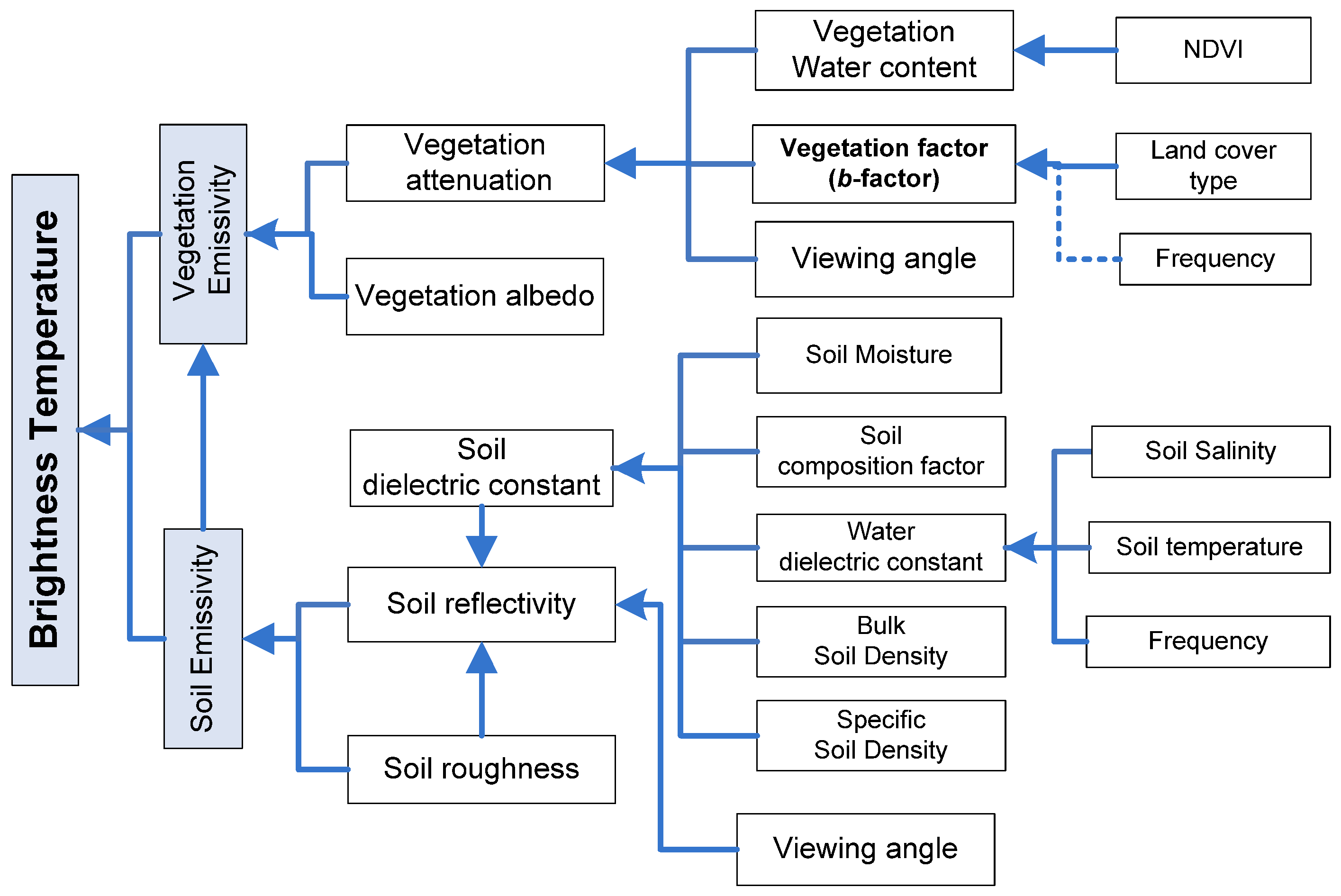
The flow chart that explicates the microwave emission model (1) is shown in Figure 1. The model is mainly divided by soil emissivity and vegetation emissivity. The b-factor is determined by land cover type and frequency and it becomes a decisive factor for vegetation attenuation along with vegetation water content. The vegetation water content can be derived from the Normalized Difference Vegetation Index (NDVI) [15]. Schmugge and Jackson [19] verified the agreement between the observed b-factor values and Ulaby-El-Rayes calculated the model [18] for dielectric properties of vegetative material model. The agreement indicates that the dominant interaction is the absorption (attenuation) by the vegetation at the longer microwave wavelength.
Figure 1. Flow chart of the microwave emission model for soil moisture retrieval.
Remotesensing 02 01273 g001

4. Sensitivity Analysis of Vegetation b-factor

4.1. Relative Sensitivity Analysis

In order to evaluate the sensitivity between the parameters, the brightness temperature was calculated using Equation (1) at four conditions in terms of soil moisture and vegetation water content as shown in Table 2. The brightness temperature was calculated using base values (Table 3) in the minimum and maximum of soil moisture (0.05 and 0.45) and vegetation water content (0.1 and 6.0). The same calculation was carried out but using the minimum and maximum range of the b-factor, soil roughness and soil temperature at different conditions. Comparing the brightness temperature differences (Δ) to soil moisture (93 K), relative sensitivities were obtained. The range of maximum and minimum values and the base values of parameters (Table 3) were adopted from different publications [11,14,20,21,22,23]. According to the investigation of other researchers the base values for vegetation water content (0.7), b-factor (0.1), and soil roughness (0.1) are not close to the arithmetic mean of the range because they are not normally distributed [2,11].
Table 2. Relative sensitivity of variable to four conditions (1) Dry and wet soil moisture condition, (2) Low and high vegetated field conditions.
VariablesConditionTb(K) using min and max rangeRelative Sensitivity (%)
minmax
soil moisture (Sm)
(range:0.05–0.45)
base257.3164.093100
veg water content (Wc)
(range:0.1–6.0)
base276.8203.67378.5
b-factor
(range:0– 0.5)
Sm = 0.05254.0274.320.321.7
Sm =0.45151.4231.780.386.1
Wc =0.1200.2211.010.711.5
Wc = 6.0200.2282.282.088.2
surface roughness
(range:0–0.3)
Sm = 0.05255.9266.911.011.9
Sm = 0.45160.9196.535.738.3
Wc = 0.1192.3220.127.930.0
Wc = 6.0265.6272.06.46.9
surface temp (k)
(range:270–320)
Sm = 0.05236.4272.536.138.7
Sm = 0.45159.2175.716.517.7
Wc = 0.1182.9208.725.727.6
Wc = 6.0270.5279.99.410.1
Table 3. Base values of parameters.
ParameterBase valueunit
Volumetric soil moisture0.2-
Vegetation water content0.7kg m−2
b-factor0.1-
Surface roughness0.1-
Surface temperature300K
Viewing angle40degree
Bulk soil density1.2g/ cm3
Specific soil density2.59g/ cm3
Soil composition (clay)0.15-
Soil composition (sand)0.20-
As a result, the relative sensitivity compared to soil moisture of the vegetation water content is 78.5%. Remarkably, the relative sensitivity of the b-factor is higher than the vegetation water content, which is 86.1% for wet soil condition (Sm = 0.45) and 88.2% for high vegetated condition (Wc = 6.0). This result indicates that the b-factor is more effective than vegetation water content at certain conditions. Therefore, the b-factor has to be considered for soil moisture retrieval. Surface roughness and temperature have moderate to low relative sensitivity. However, the interesting point is that the sensitivity of each parameter varies under different conditions. For example, the b-factor shows a high sensitivity at wet soil and high vegetated condition, surface roughness is comparatively sensitive at wet soil and low vegetated condition and dry soil and low vegetated condition for surface temperature. Hence, using suitable b-factors at different soil conditions and vegetation types is suggested for soil moisture retrieval rather than constant single value.
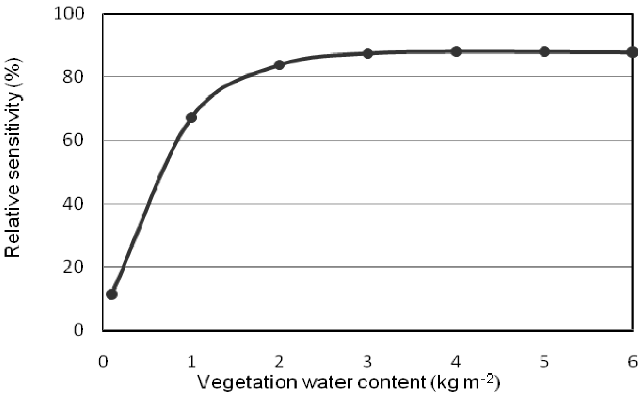
Figure 2. Relative sensitivity of b-factor with respect to vegetation water content.
Remotesensing 02 01273 g002
In order to ensure how the vegetation water content affect to the b-factor sensitivity, the relative sensitivity of the b-factor is plotted with respect to the vegetation water content as presented in Figure 2. It shows that the relative sensitivity is rapidly increased when the vegetation water content is between 0 and 1 and already saturated at 2. Therefore, the b-factor affects the microwave emission significantly when Wc > 1. In this figure, the base soil moisture (0.2) is used. Thus, for the higher soil moisture, the bigger impact on sensitivity is expected.
Table 4 is the summary of the b-factor data that has been sorted out at only low frequency (1.4 or 1.6 GHz) for five vegetation types from different literature, which was tabulated by [12], and [14]. The b-factors for a specific vegetation type were mostly calculated from given vegetation water content and τ in the literatures. If there are two growth stages or angular dependence in the literature, the b-factors were calculated from different vegetation water contents or angles and the average was taken.
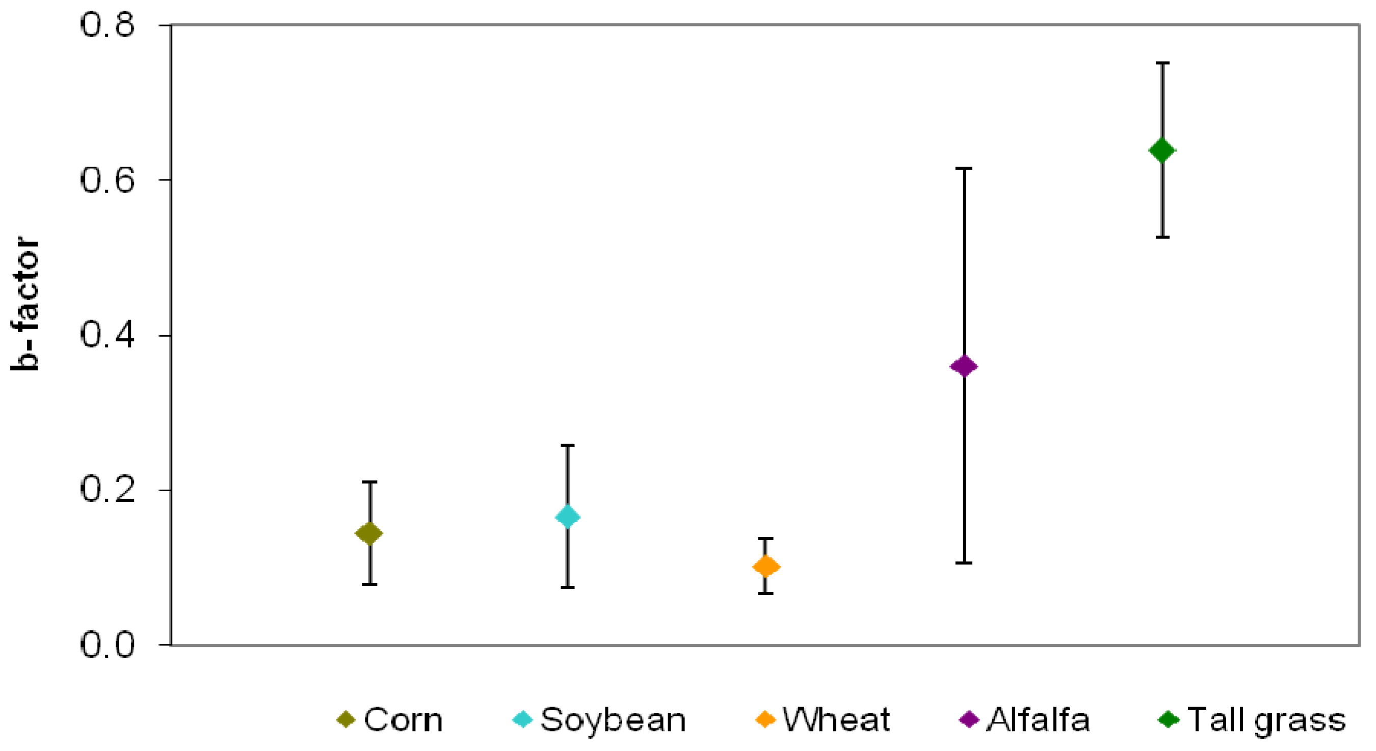
It was observed that the b-factors between literatures sources vary although they are in the same vegetation cover in Table 4. The corn has b-factors from 0.1 to 0.26. The range of soybean is from 0.08 to 0.3, wheat is from 0.05 to 0.13, alfalfa has 0.18 and 0.54, and tall grass has 0.56 and 0.72. Considering a large variation, inappropriate selection of the b-factor can results in significant errors. Figure 3 is the averaged b-factor for each vegetation type with standard deviation range. Alfalfa and tall grass have large standard deviation range, however, more research on these vegetation types is required for general analysis.
Table 4. The b-factor for different vegetation covers at L-band.
Sourceƒ(GHz)Vegetation typeb-factorVegetation water content (kg/m2)
Jackson and O’neill [24] 1.4Corn0.1152.7 to 4.5
Ulaby, Ranzani et al.[25]1.4Corn0.1134.0
Jackson, Schmugge et al.[13]1.4Corn0.1331.2
O'Neill, Jackson et al.[22] 1.4Corn0.1026.0
Parde et al.[23] 1.4Corn0.26 ± 0.04-
Jackson and O'neill[24] 1.4Soybean0.086-
Ulaby and Wilson [26]1.6Soybean0.1001.8
Jackson et al.[13]1.4Soybean0.0871.0
Wigneron, Chanzy et al.[27]1.4Soybean0.19 ± 0.01-
Haboudane, Chanzy et al.[28]1.4Soybean0.28 ±0.03-
Burke, Wigneron et al.[29]1.4Soybean0.1222.4 and 5.2
Parde et al.[23]1.4Soybean0.30 ± 0.02-
Ulaby and Wilson [26]1.6Wheat0.0505.2
Wigneron, Chanzy et al.[27]1.4Wheat0.12 ± 0.01-
Haboudane, Chanzy et al.[28]1.4Wheat0.13 ± 0.01-
Parde et al.[23]1.4Wheat0.11 ± 0.01-
Chukhlantsev and Shutko [30]1.6Alfalfa0.1822.0
Parde et al.[23]1.4Alfalfa0.54 ± 0.02-
Wang [31]1.4Tall grass0.720.4
Parde et al.[23]1.4Tall grass0.56 ± 0.05-
Figure 3. Averaged b-factor and the range for different vegetation type.
Remotesensing 02 01273 g003

4.2. Field Application of Sensitivity Analysis
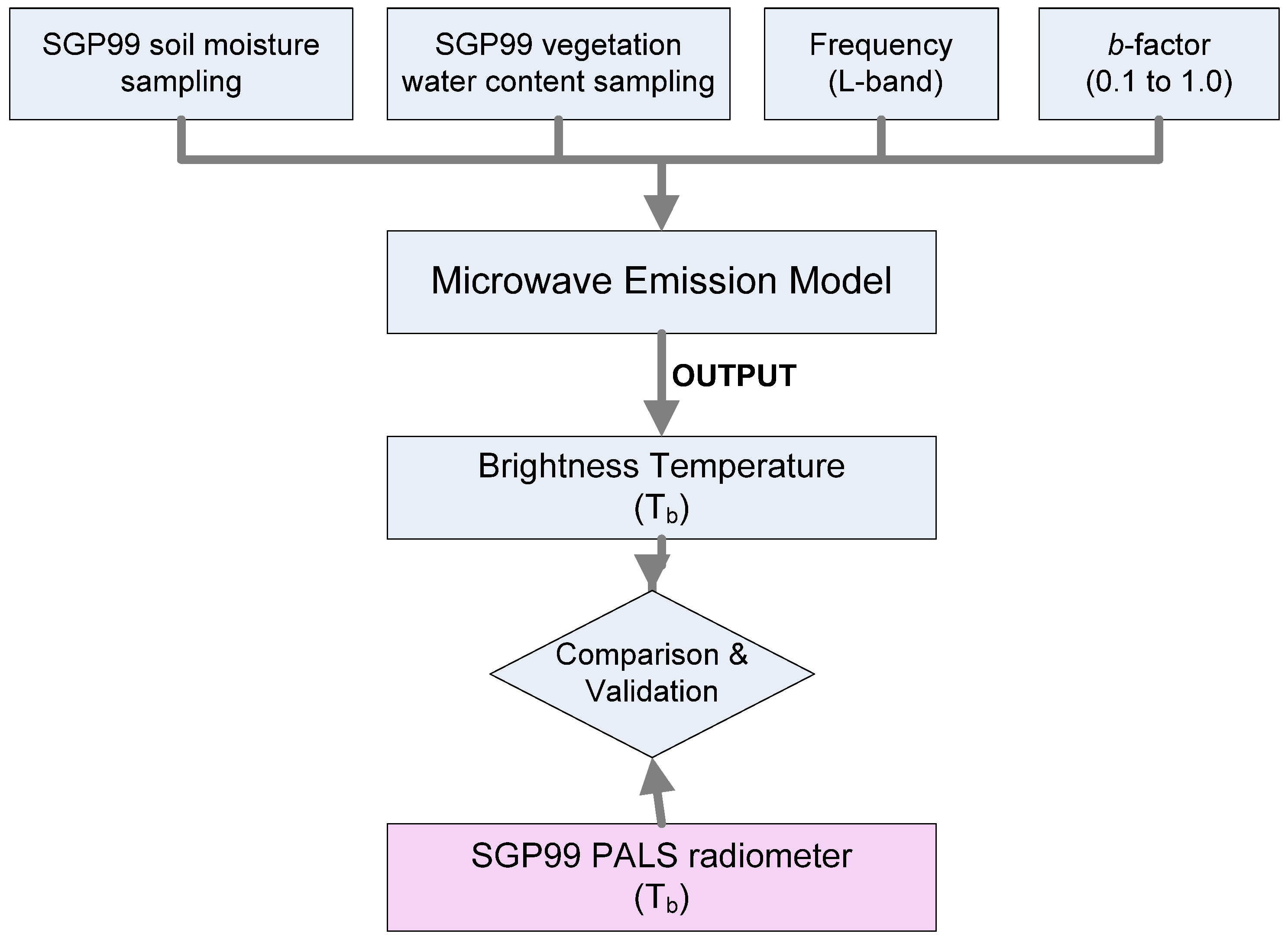
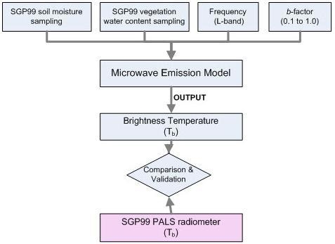
The measured data from SGP99 was used to evaluate the importance of the b-factor. As described in Figure 4, the soil moisture and the vegetation water content data sampled from Little Washita site and other variables (Table 3) were applied to the microwave emission model (1) in order to estimate the brightness temperature for the range of the b-factor from 0.1 to 1.0. The brightness temperature measured from PALS airborne radiometer was compared to the model output results.
Figure 4. Flowchart of the validation of brightness temperature using the microwave emission model.
Remotesensing 02 01273 g004
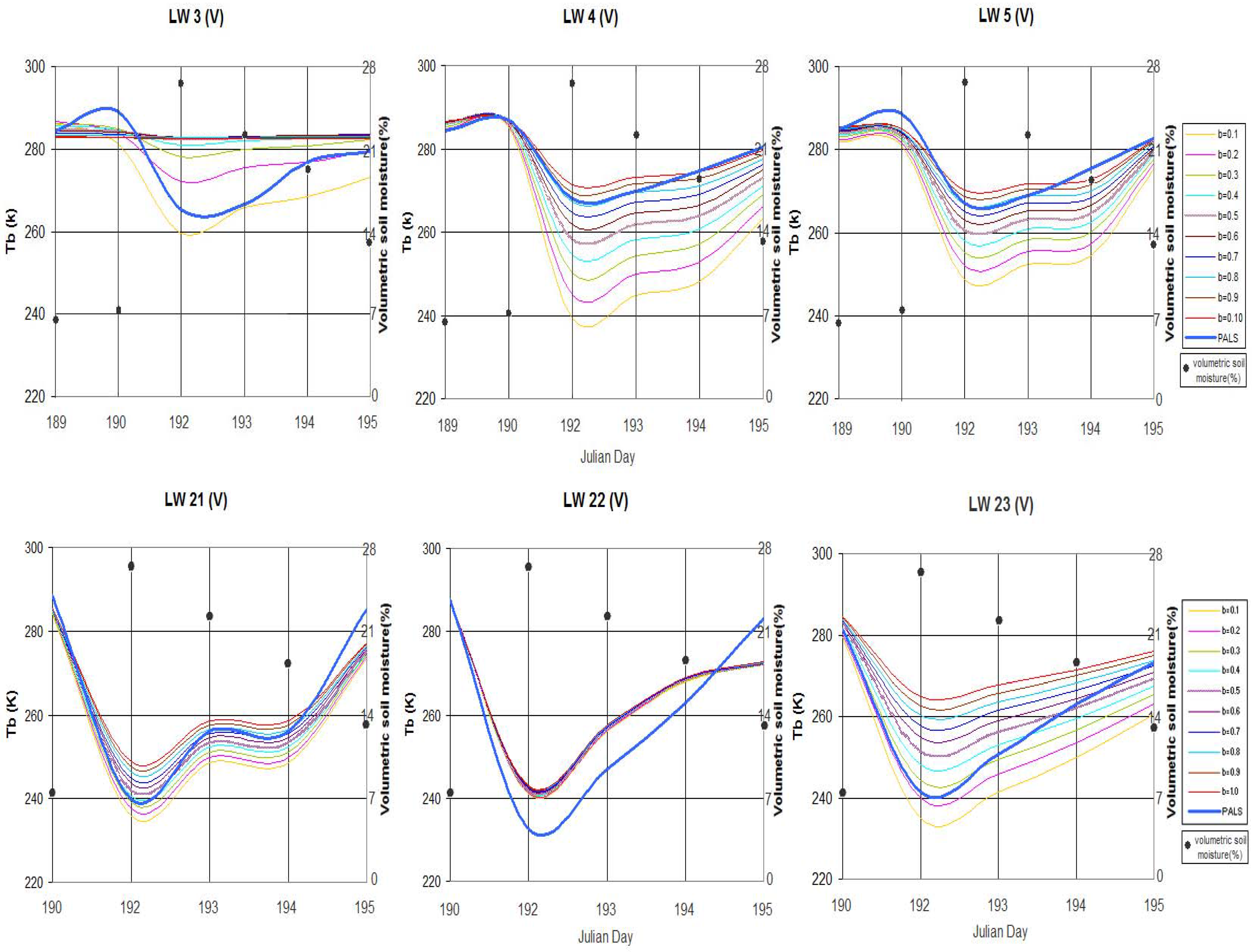
The comparison of brightness temperature from PALS radiometer and microwave emission model varying b-factor is shown along with the corresponding volumetric soil moisture in Figure 5. The graphs in Figure 5 demonstrate the brightness temperature variability as the b-factor changes in the microwave emission model calculation with ground sampling input of the soil moisture and the vegetation water content. Sites 3, 4, 5, 21, 22 and 23 in Little Washita were analyzed since these sites have available data for both PALS and measured sampling in the same dates. The data are accessible for six days from July 8th (Julian day 189) through 14th (Julian day 195) at LW 3, LW 4 and LW 5, and five days at LW 21, LW 22 and LW 23 in 1999. The land cover type of the LW 3, LW 4 and LW 5 is rangeland, and the LW 21, LW 22 and LW 23 is wheat (Table 5).
The soil moisture data has converted from gravimetric which originally sampled in SGP99 to volumetric, then averaged at each day for studied LW sites. The solid dots represent volumetric soil moisture in Figure 5. A considerable increase of volumetric soil moisture from 7% to 27% was observed between day 190 and 192, which was deduced as precipitation occurred. It is noticeable that the brightness temperatures have became apart each other as the b-factor changes when precipitation occurred (day 192). The gap is reducing afterward as the volumetric soil moisture decrease. In other words, the brightness temperature depends on the b-factor when the soil is saturated. This phenomenon applies well when the value of the vegetation water content is high. The vegetation water content in LW 22 was measured as 0.02 kg/m2 and the b-factor is almost constant whereas relatively high vegetation water content (2.38 kg/m2, 0.48 kg/m2) in LW 3 and LW 4 shows large variation. Hence, despite the different vegetation water content, applying the same b-factor for a vegetation type may increase error in brightness temperature estimation. Figure 5 proves high sensitivity of the b-factor in wet condition and with high vegetation water content that was discussed in Table 2.
Thick blue solid line in Figure 5 is actual brightness temperature data acquired from the PALS. The closest brightness temperature to the PALS data would be the optimal value of the b-factor. However, the closest brightness temperature is different at each site because the b-factor depends on vegetation water content and soil moisture. The closest brightness temperature is found when the b-factors are 0.7 in LW 4, 0.8 to 1.0 in LW 5, 1.0 in LW 21 and 0.3 to 0.8 in LW 23.
Figure 5. Brightness temperature from PALS radiometer (blue wide line) compared with microwave emission model varying b-factor and the corresponding volumetric soil moisture.
Remotesensing 02 01273 g005
Table 5. Land cover type and vegetation water content at each site from SGP99.
Site IDLand coverVegetation water content (Wc)
LW3Rangeland2.38 kg/m2
LW4Rangeland0.48 kg/m2
LW5Rangeland0.34 kg/m2
LW21Wheat0.12 kg/m2
LW22Wheat0.02 kg/m2
LW23Wheat0.36 kg/m2
Table 6. Correlation coefficient (R), Root Mean Squared Error (RMSE), and bias values at b-factors (from 0.1 to 1.0) in LW 4, 5 and LW 21, 22, 23.
LW 4,5 (Rangeland)LW 21,22,23 (Wheat)
b-factorRRMSEBiasb-factorRRMSEBias
0.10.97137.23635.6000.10.94824.90523.611
0.20.9728.648−7.6600.20.95421.72620.336
0.30.96624.03723.0060.30.94619.25517.318
0.40.95918.61617.7290.40.92517.50014.530
0.50.95013.91513.0240.50.89416.45111.958
0.60.9399.9718.8380.60.85616.0389.578
0.70.9266.9625.1070.70.81516.1497.378
0.80.9115.4011.7840.80.77416.6485.340
0.90.8955.700−1.1740.90.73417.4053.453
1.00.8797.200−3.8001.00.69718.3161.701
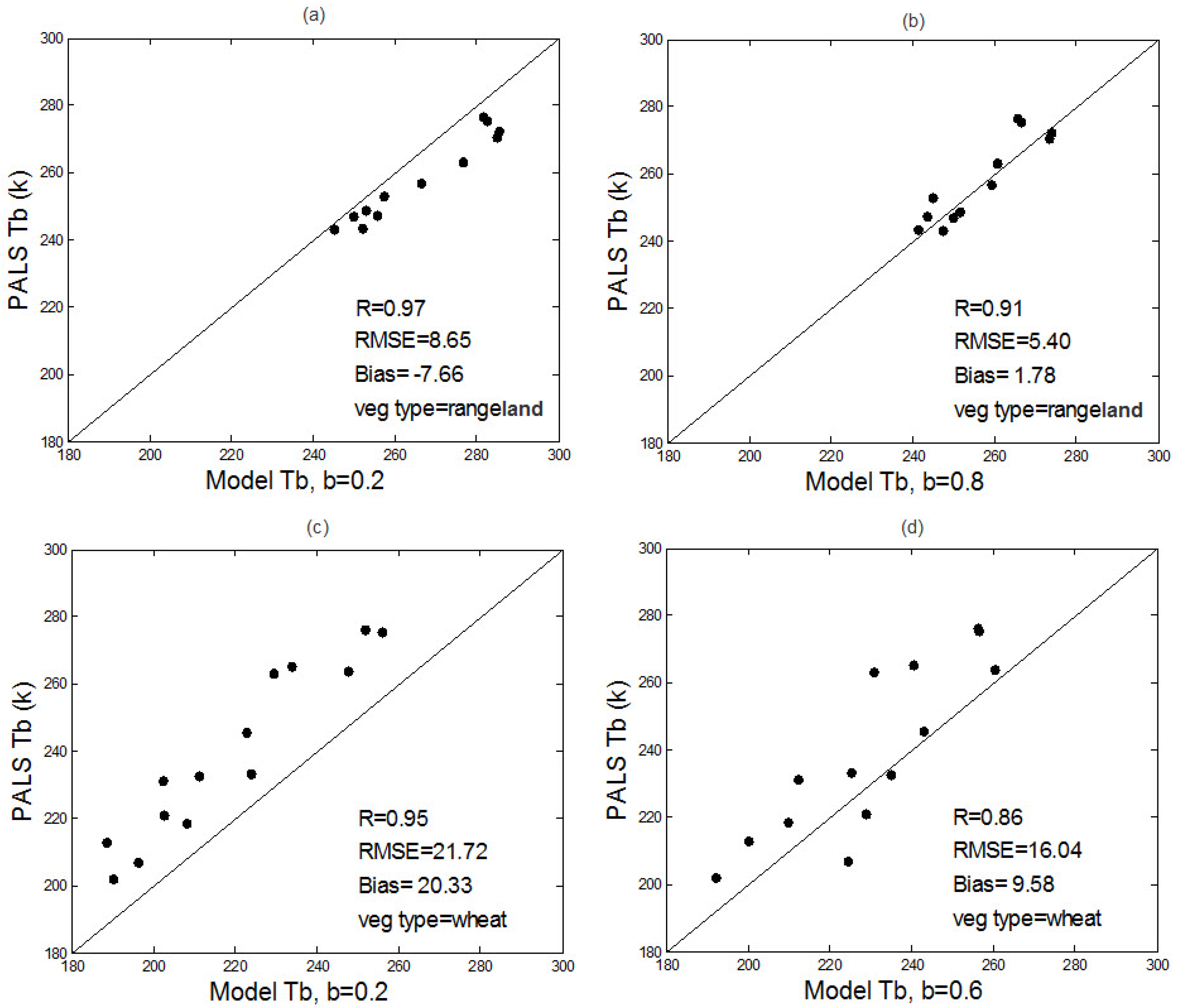
The brightness temperature measures using PALS and estimated from the microwave emission model is statistically analyzed. The correlation coefficient, RMSE, and bias have been computed in Table 6. For both the rangeland and wheat, the correlation coefficient (R) is the highest when the b-factors are 0.2 as 0.97 and 0.95 respectively and only slight difference is observed between when the b-factors are 0.1 and 0.2. However, when b-factor is 0.2, the RMSE (8.648) and bias (−7.66) are far lower than those of when b-factor is 0.1 for the rangeland. The lowest RMSE is 5.4 when the b-factor is 0.8 for the rangeland and 16.04 when the b-factor is 0.6 for the wheat. Thus, the b-factor of 0.2 gives the highest correlation in the validation of the microwave emission model, which is close to the average b-factor of wheat in other literature investigation as referred in Table 4. However, the b-factors that create the lowest errors differ extensively.
The b-factors for the highest correlation coefficient and the lowest root mean square error are presented to scattered graph in Figure 6. The sites were grouped as vegetation type characteristics. In Figure 6, (a) and (b) are LW 4 and 5 which are the rangeland, (c) and (d) are the wheat in LW 21, LW 22 and 23. Furthermore, in order to address the closest value of which vegetation cover type, constant value of the b-factor at each vegetation type is placed into the model even though the b-factor yields irregular brightness temperature in different conditions.
Figure 6. Correlation between PALS measured and calculated by Model: LW 4, 5 (a) b = 0.2 (b) b = 0.8 and LW 21, 22, 23 (c) b = 0.2 (d) b = 0.6.
Remotesensing 02 01273 g006

5. Summary and Conclusion

Considering the effect of the b-factor to the soil moisture retrieval, which is the main factor of the optical depth along with the vegetation water content, the sensitivity analysis for the microwave emission model is carried out. The sensitivities of three different variables are computed as comparing to the soil moisture relatively. The b-factor showed the highest sensitivity for wet soil and when the vegetation water content is above 1 kg/m2. The vegetation water content is little less sensitive than the b-factor in these conditions with base values. The surface roughness and temperature has moderate to low sensitivity relatively. Yet, it is observed that the efficiency of each variable varies with different soil and vegetation conditions. Therefore, the weight of the b-factor should be the same ranking as the vegetation water content in the microwave emission model for the soil moisture retrieval.
In order to investigate the importance of the b-factor, the brightness temperature that generated by the microwave emission model using ground sampling soil moisture data from SGP99 were evaluated with that obtained by the PALS radiometer. This evaluation confirmed that the b-factor is depending on different soil and vegetation conditions, which was proved in sensitivity analysis. The brightness temperature measured by the PALS and the model output comparison graph (Figure 5) showed that when the precipitation occurred there is dramatic change of the b-factor sensitivity as the variation of brightness temperature is being large and it is more remarkable when the vegetation water content is high.
The statistical analysis is carried out for grouped sites that are in the same vegetation cover. When the b-factor is 0.2, it gives the highest correlation for both the rangeland and wheat. However, the lowest values of the root mean square error and bias are when b-factor is 0.8 and 0.6 for the rangeland and wheat respectively. The closest b-factor (0.2) obtained from the evaluation does not perfectly agree with the b-factors in other literature (Table 4). It is because the vegetation water content is fairly small in the SGP99 field data (Table 5). Therefore, further evaluation is required with higher vegetation water content in variety of the vegetation types.
The evaluation of the b-factor in this study obtains a better understanding of the microwave emission model for the soil moisture and will contribute the improvement of the future satellite, SMAP (Soil Moisture Active Passive), which utilizes a unique active and passive L-band microwave concept to measure the microwave emission and backscatter simultaneously.

Acknowledgements

This study was supported and monitored by National Oceanic and Atmospheric Administration (NOAA) under Grant NA06OAR4810162. The views, opinions, and findings contained in this report are those of the author(s) and should not be construed as an official National Oceanic and Atmospheric Administration or US Government position, policy, or decision. Authors would like to thank Andrew S. Jones from Cooperative Institute for Research in the Atmosphere, Colorado State University for useful discussion and suggestions.

References and Notes

  1. Beljaars, A.C.M.; Viterbo, P.; Miller, M.J.; Betts, A.K. The anomalous rainfall over the United States during July 1993: Sensitivity to land surface parameterization and soil moisture anomalies. Mon. Weather Rev. 1996, 124, 362–383. [Google Scholar] [CrossRef]
  2. Jackson, T.J.; Vine, D.M.L.; Hsu, A.Y.; Oldak, A.; Starks, P.J.; Swift, C.T.; Isham, J.; Haken, M. Soil moisture mapping at regional scales using the microwave radiometry: the Southern Great Plains hydrology experiment. IEEE Trans. Geosci. Remote Sens. 1999, 37, 2135–2151. [Google Scholar] [CrossRef]
  3. Ulaby, F.T.; Moore, R.; Fung, A. Microwave Remote Sensing Active and Passive From Theory to Applications; Artech House: Norwood, MA, USA, 1986. [Google Scholar]
  4. Jackson., T.J.; Vine, D.M.L.; Swift, C.T.; Schmugge, T.J.; Schiebe, F.R. Large area mapping of soil moisture using the ESTAR passive microwave radiometer in Washita ’92. Remote Sens. Environ. 1995, 53, 27–37. [Google Scholar] [CrossRef]
  5. Lakhankar, T.; Ghedira, H.; Temimi, M.; Sengupta, M.; Khanbilvardi, R.; Blake, R. Non-parametric methods for soil moisture retrieval from satellite remote sensing data. Remote Sens. 2009, 1, 3–21. [Google Scholar] [CrossRef] [Green Version]
  6. Kerr, Y.H.; Waldteufel, P.; Wigneron, J.P.; Delwart, S.; Cabot, F.; Boutin, J.; Escorihuela, M.J.; Font, J.; Reul, N.; Gruhier, C.; Juglea, S.E.; Drinkwater, M.R.; Hahne, A.; MartAn-Neira, M.; Mecklenburg, S. The SMOS mission: New tool for monitoring key elements of the global water cycle. IEEE Trans. Geosci. Remote Sens. 2010, 98, 1–22. [Google Scholar] [CrossRef] [Green Version]
  7. Entekhabi, D.; O’Neil, E.N.P.; Jackson, T.; Thomas, J.; Entin, J.; Eastwood, I. The soil moisure active/passive mission (SMAP). In Proceedings of IEEE Int. Geoscience Remote Sensing Symposium, Boston, MA, USA, July 2008.
  8. Kirdyashev, K.P.; Chukhlantsev, A.A.; Shutko, A.M. Microwave radiation of the Earth’s surface in the presence of a vegetation cover. Radio Eng. Electron. Phys. 1979, 24, 37–44. [Google Scholar]
  9. Wang, J.R.; Schmugge, T.J. An empirical model for the complex dielectric permittivity of soils as a function of water content. IEEE Trans. Geosci. Remote Sens. 1980, 18, 288–295. [Google Scholar] [CrossRef]
  10. Dobson, M.C.; Ulaby, F.T.; Hallikainen, M.T.; El-Rayes, M.A. Microwave dielectric behavior of wet soil-part II: Dielectric mixing models. IEEE Trans. Geosci. Remote Sens. 1985, GE-23, 35–46. [Google Scholar] [CrossRef]
  11. Gao, H.; Wood, E.F. Using a microwave emission model to estimate soil moisture from ESTAR observation during SGP 99. J. Hydrometeorol. 2004, 5, 49–63. [Google Scholar] [CrossRef]
  12. Jackson, T.J.; Schmugge, T. Vegetation effects on the microwave emission of soils. Remote Sens. Environ. 1991, 36, 203–212. [Google Scholar] [CrossRef]
  13. Jackson, T.J.; Schmugge, T.J.; Wang, J.R. Passive microwave remote sensing of soil moisture under vegetation canopies. Water Resour. Res. 1982, 18, 1137–1142. [Google Scholar] [CrossRef]
  14. Van de Griend, A.A.; Wigneron, J.-P. The b-factor as a function of frequency and canopy type at H-polarization. IEEE Trans. Geosci. Remote Sens. 2004, 42, 786–794. [Google Scholar] [CrossRef]
  15. Jackson, T.J.; Vine, D.L.; Hsu, A.Y.; Oldak, A.; Starks, P.; Swift, C.; Isham, J.; Haken, M. Soil moisture mapping at regional scales using microwave radiometry: the Southern Great Plains Hydrology Experiment. IEEE Trans. Geosci. Remote Sens. 1999, 37, 2136–2151. [Google Scholar] [CrossRef]
  16. Njoku, E.G.; Wilson, W.J.; Yueh, S.H.; Dinardo, S.J.; Li, F.K.; Jackson, T.J.; Lakshmi, V.; Bolten, J. Observations of soil moisture using a passive and actove low-frequency microwave airborne sensor during SGP99. IEEE Trans. Geosci. Remote Sens. 2002, 40, 2659–2673. [Google Scholar] [CrossRef]
  17. Crow, W.T.; Chan, S.T.K.; Entekhabi, D.; Houser, P.R.; Hus, A.Y.; Jackson, T.J.; Njoku, E.G.; O’Neill, P.E.; Shi, J.; Zhan, X. An observing system simulation experiment for Hydrow radiometer-only soil moisture products. IEEE Trans. Geosci. Remote Sens. 2005, 43, 1289–1303. [Google Scholar] [CrossRef]
  18. Ulaby, F.T.; El-Rayes, M.A. Microwave dielectric spectrum of vegetation Part II: Dual dispersion model. IEEE Trans. Geosci. Remote Sens. 1987, GE-25, 550–557. [Google Scholar] [CrossRef]
  19. Schmugge, T.J.; Jackson, T.J. A dielectric model of the vegetation effects on the microwave emission from soils. IEEE Trans. Geosci. Remote Sens. 1992, 30, 757–760. [Google Scholar] [CrossRef]
  20. Njoku, E.G.; Li, L. Retrieval of land surface parameters using passive microwave measurements at 6-18 GHz. IEEE Trans. Geosci. Remote Sens. 1999, 37, 79–93. [Google Scholar] [CrossRef]
  21. Jones, A.S.; Vukicevic, T.; Vonder-Haar, T.H. A microwave satellite observational operator for variational data assimilation of soil moisture. J. Hydrometeorol. 2004, 5, 213–229. [Google Scholar] [CrossRef]
  22. O’Neill, P.E.; Jackson, T.J.; Blanchard, B.; van den Hoek, R.; Gould, W.; Wang, J.; Glazar, W.; McMurtey, J., III. The Effects of Vegetation and Soil Hydraulic Properties on Passive Microwave Sensing of Soil Moisture: Data Report for the 1982 Field Experiments; NASA Tech. Memorandum 85106; NASA: Greenbelt, MD, USA, 1983. [Google Scholar]
  23. Parde, M.; Wigneron, J.-P.; Chanzy, A.; Waldteufel, P.; Kerr, Y.; Huet, S. Retrieving surface soil moisture over a wheat field: Comparison of different methods. Remote Sens. Environ. 2003, 87, 334–344. [Google Scholar] [CrossRef]
  24. Jackson, T.J.; O’Neill, P.E. Attenuation of soil microwave emissivity by corn and soybeans at 1.4 and 5 GHz. IEEE Trans. Geosci. Remote Sens. 1990, GE-28, 978–980. [Google Scholar] [CrossRef]
  25. Ulaby, F.T.; Ranzani, M.; Dobson, M.C. Effects of vegetation cover on the microwave radiometric sensitivity to soil moisture. IEEE Trans. Geosci. Remote Sens. 1983, GE-21, 51–61. [Google Scholar] [CrossRef]
  26. Ulaby, F.T.; Wilson, E.W. Microwave attenuation properties of vegetation canopies. IEEE Trans. Geosci. Remote Sens. 1985, GE-23, 746–753. [Google Scholar] [CrossRef]
  27. Wigneron, J.-P.; Chanzy, A.; Calvet, J.-C.; Bruguier, N. A simple algorithm to retrieve soil moisture and vegetation biomass using passive microwave measurements over crop fields. Remote Sens. Environ. 1995, 51, 331–341. [Google Scholar] [CrossRef]
  28. Haboudane, D.; Chanzy, A.; Calvet, J.-C.; Wigneron, J.-P.; Bonn, F. Radiometrie micro-onde dans le cas des couverts vegetaux partiels: Etimation de la teneur en eau du soil. Can. J. Remote Sens., 1996, 22, 208–217. [Google Scholar] [CrossRef]
  29. Burke, E.J.; Wigneron, J.-P.; Gurney, R.J. The comparison of two models that determine the effects of a vegetation canopy on passive microwave emission. Hydrol. Earth. Syst. Sci 1999, 3, 439–444. [Google Scholar] [CrossRef]
  30. Chukhlantsev, A.A.; Shutko, A.M. An account of the effect of vegetation during remote microwave radiometric sounding of terrestrial deposits. Remote Sens. Earth Space 1988, 2, 67–72. [Google Scholar]
  31. Wang, J.; Shiue, J.; Engman, E.; McMurtrey, J.; Lawless, I.P.; Schmugge, T.J.; Jackson, T.J.; Gould, W.; Fuchs, J.; Calhoon, C.; Carnahan, T.; Hirschmann, E. Remote Measurements of Soil Moisture by Microwave Radiometers at Barc Test Site; Tech. Memo 80720; NASA: Greenbelt, MD, USA, 1980. [Google Scholar]