Using Lidar-Derived Vegetation Profiles to Predict Time since Fire in an Oak Scrub Landscape in East-Central Florida


Abstract
:1. Introduction
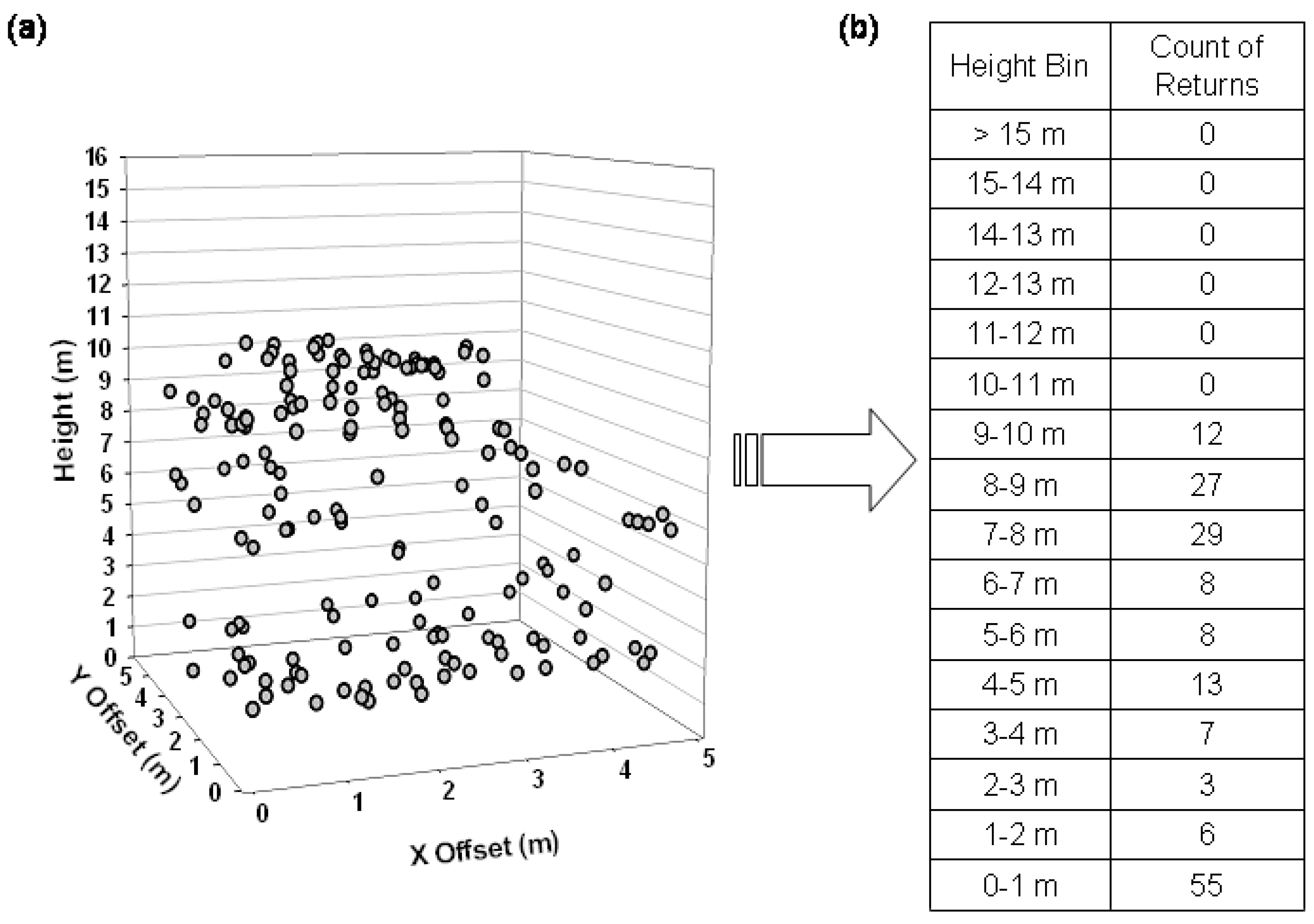
2. Methods
2.1. Study Area
2.2. Lidar Data Acquisition and Pre-Processing

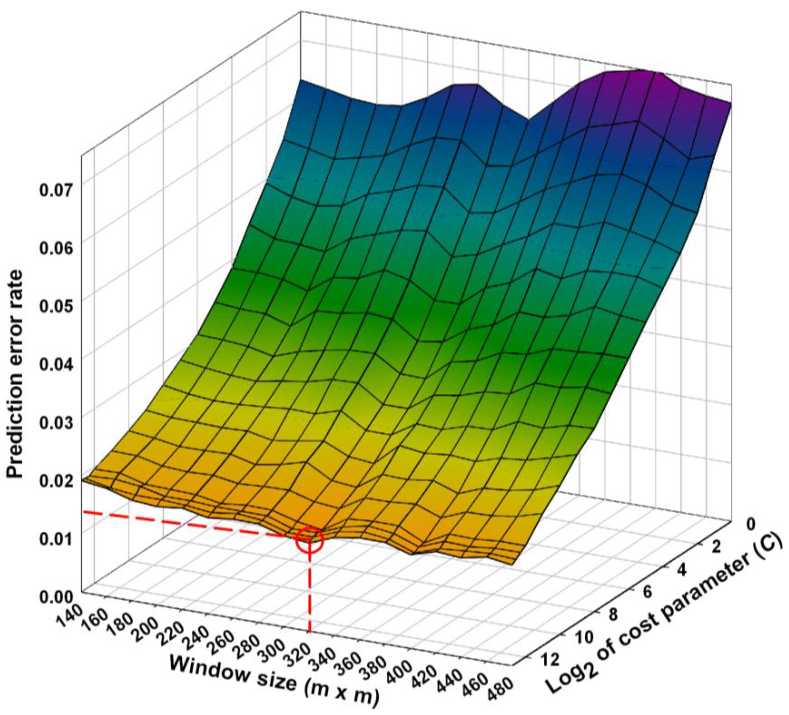
2.3. Data Analyses
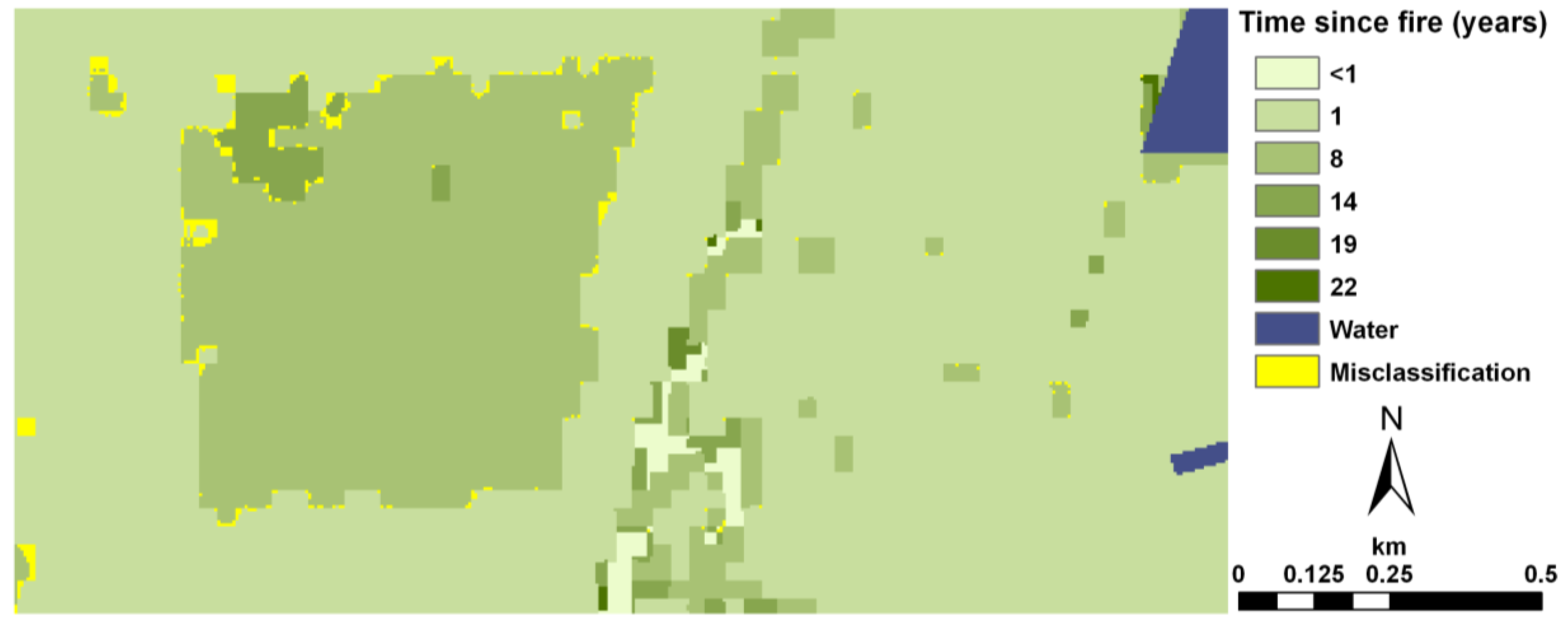
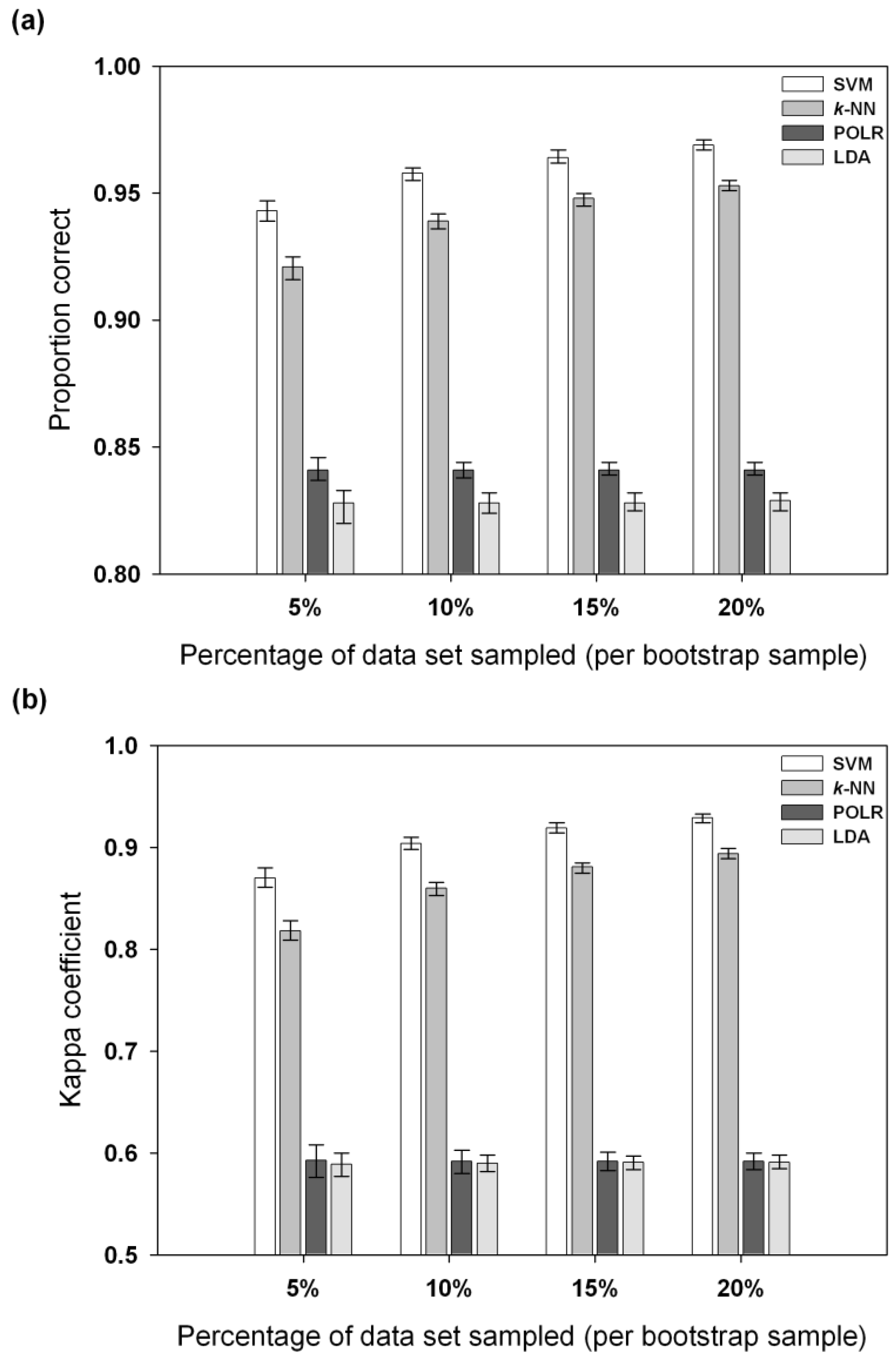
3. Results


4. Discussion and Conclusions
Acknowledgements
References
- White, P.S. Pattern, process, and natural disturbance in vegetation. Bot. Rev. 1979, 45, 229–299. [Google Scholar] [CrossRef]
- Oliver, C.D. Forest development in North America following major disturbances. Forest Ecol. Manage. 1980, 3, 153–168. [Google Scholar] [CrossRef]
- Brokaw, N.; Lent, R. Vertical structure. In Maintaining Biodiversity in Forest Ecosystems; Hunter, M., Ed.; Cambridge University Press: Cambridge, UK, 1999; pp. 373–399. [Google Scholar]
- Tierney, G.L.; Faber-Langendoen, D.; Mitchell, B.R.; Shriver, W.G.; Gibbs, J.P. Monitoring and evaluating the ecological integrity of forest ecosystems. Front. Ecol. Environ. 2009, 7, 308–316. [Google Scholar] [CrossRef]
- Ahlgren, I.F.; Ahlgren, C.E. Ecological effects of forest fires. Bot. Rev. 1960, 26, 483–533. [Google Scholar] [CrossRef]
- Bond, W.J.; Keeley, J.E. Fire as a global ‘herbivore’: the ecology and evolution of flammable ecosystems. Trend. Ecol. Evolut. 2005, 20, 387–394. [Google Scholar] [CrossRef] [PubMed]
- Parisien, M.A.; Moritz, M.A. Environmental controls on the distribution of wildfire at multiple spatial scales. Ecol. Monogr. 2009, 79, 127–154. [Google Scholar] [CrossRef]
- Landres, P.B.; Morgan, P.; Swanson, F.J. Overview of the use of natural variability concepts in managing ecological systems. Ecol. Appl. 1999, 9, 1179–1188. [Google Scholar]
- Foster, D.; Swanson, F.; Aber, J.; Burke, I.; Brokaw, N.; Tilman, D.; Knapp, A. The importance of land-use legacies to ecology and conservation. Bioscience. 2003, 53, 77–88. [Google Scholar] [CrossRef]
- Romme, W.H. Fire and landscape diversity in subalpine forests of Yellowstone National Park. Ecol. Monogr. 1982, 52, 199–221. [Google Scholar] [CrossRef]
- Turner, M.G.; Hargrove, W.W.; Gardner, R.H.; Romme, W.H. Effects of fire on landscape heterogeneity in Yellowstone National Park, Wyoming. J. Veg. Sci. 1994, 5, 731–742. [Google Scholar] [CrossRef]
- DeFries, R. Terrestrial vegetation in the coupled human-Earth system: contributions of remote sensing. Ann. Rev. Environ. Res. 2008, 33, 369–390. [Google Scholar] [CrossRef]
- Shao, G.; Duncan, B.W. Effects of band combinations and GIS masking on fire-scar mapping at local scales in east-central Florida, USA. Can. J. Remote Sens. 2007, 33, 250–259. [Google Scholar] [CrossRef]
- Lefsky, M.A.; Cohen, W.B.; Parker, G.G.; Harding, D.J. Lidar remote sensing for ecosystem studies. Bioscience 2002, 52, 19–30. [Google Scholar] [CrossRef]
- Omasa, K.; Hosoi, F.; Konishi, A. 3D lidar imaging for detecting and understanding plant responses and canopy structure. J. Exp. Bot. 2007, 58, 881–898. [Google Scholar] [CrossRef] [PubMed]
- Zimble, D.A.; Evans, D.L.; Carlson, G.C.; Parker, R.C.; Grado, S.C.; Gerard, P.D. Characterizing vertical forest structure using small-footprint airborne LiDAR. Remote Sens. Environ. 2003, 87, 171–182. [Google Scholar] [CrossRef]
- Hurtt, G.C.; Dubayah, R.; Drake, J.; Moorcroft, P.R.; Pacala, S.W.; Blair, J.B.; Fearon, M.G. Beyond potential vegetation: combining lidar data and a height-structured model for carbon studies. Ecol. Appl. 2004, 14, 873–883. [Google Scholar] [CrossRef]
- Naesset, E. Practical large-scale forest stand inventory using a small-footprint airborne scanning laser. Scand. J. Forest Res. 2004, 19, 164–179. [Google Scholar] [CrossRef]
- Boelman, N.T.; Asner, G.P.; Hart, P.J.; Martin, R.E. Multi-trophic invasion resistance in Hawaii: Bioacoustics, field surveys, and airborne remote sensing. Ecol. Appl. 2007, 17, 2137–2144. [Google Scholar] [CrossRef] [PubMed]
- Koetz, B.; Morsdorf, F.; van der Linden, S.; Curt, T.; Allgöwer, B. Multi-source land cover classification for forest fire management based on imaging spectrometry and LiDAR data. Forest Ecol. Manage. 2008, 256, 263–271. [Google Scholar] [CrossRef]
- Falkowski, M.J.; Evans, J.S.; Martinuzzi, S.; Gessler, P.E.; Hudak, A.T. Characterizing forest succession with lidar data: An evaluation for the Inland Northwest, USA. Remote Sens. Environ. 2009, 113, 946–956. [Google Scholar] [CrossRef]
- Schmalzer, P.A.; Hinkle, C.R. Effects of Fire on Composition, Biomass, and Nutrients in Oak Scrub Vegetation on John F. Kennedy Space Center, Florida; National Aeronautics and Space Administration: Kennedy Space Center, FL, USA, 1987; p. 149.
- Menges, E.S. Ecology and conservation of Florida scrub. In Savannas, Barrens, and Rock Outcrop Plant Communities of North America; Anderson, R.C., Fralish, J.S., Baskin, J.M., Eds.; Cambridge University Press: New York, NY, USA, 1999; pp. 7–22. [Google Scholar]
- Duncan, B.W.; Boyle, S.; Breininger, D.R.; Schmalzer, P.A. Coupling past management practice and historic landscape change on John F. Kennedy Space Center, Florida. Landscape Ecol. 1999, 14, 291–309. [Google Scholar] [CrossRef]
- Duncan, B.W.; Shao, G.F.; Adrian, F.W. Delineating a managed fire regime and exploring its relationship to the natural fire regime in East Central Florida, USA: a remote sensing and GIS approach. Forest Ecol. Manage. 2009, 258, 132–145. [Google Scholar] [CrossRef]
- McGaughey, R.J. FUSION/LDV: Software for LIDAR Data Analysis and Visualization; US Department of Agriculture, Forest Service, Pacific Northwest Research Station: Seattle, WA, USA, 2009; p. 123. [Google Scholar]
- SJRWMD. SJRWMD Land Use and Land Cover–2004; St. Johns River Water Management District: Palatka, FL, USA, 2006. [Google Scholar]
- Karatzoglou, A.; Smola, A.; Hornik, K.; Zeileis, A. kernlab–An S4 package for kernel methods in R. J. Stat. Softw. 2004, 11, 1–20. [Google Scholar] [CrossRef]
- R: A Language and Environment for Statistical Computing; R Development Core Team, R Foundation for Statistical Computing: Vienna, Austria, 2008.
- Burges, C.J.C. A tutorial on support vector machines for pattern recognition. Data Min. Knowl. Discov. 1998, 2, 121–167. [Google Scholar] [CrossRef]
- Dalponte, M.; Bruzzone, L.; Gianelle, D. Fusion of hyperspectral and LIDAR remote sensing data for classification of complex forest areas. IEEE Trans. Geosci. Remote Sens. 2008, 46, 1416–1427. [Google Scholar] [CrossRef]
- Melgani, F.; Bruzzone, L. Classification of hyperspectral remote sensing images with support vector machines. IEEE Trans. Geosci. Remote Sens. 2004, 42, 1778–1790. [Google Scholar] [CrossRef]
- Tan, C.O.; Özesmi, U.; Beklioglu, M.; Per, E.; Kurt, B. Predictive models in ecology: comparison of performances and assessment of applicability. Ecol. Inform. 2006, 1, 195–211. [Google Scholar] [CrossRef]
- Fielding, A.H. Cluster and Classification Techniques for the Biosciences; Cambridge University Press: Cambridge, UK, 2007; p. 246. [Google Scholar]
- Holling, C.S. Cross-scale morphology, geometry, and dynamics of ecosystems. Ecol. Monogr. 1992, 62, 447–502. [Google Scholar] [CrossRef]
- Brown, R.T.; Agee, J.K.; Franklin, J.F. Forest restoration and fire: principles in the context of place. Conserv. Biol. 2004, 18, 903–912. [Google Scholar] [CrossRef]
© 2010 by the authors; licensee MDPI, Basel, Switzerland. This article is an open access article distributed under the terms and conditions of the Creative Commons Attribution license (http://creativecommons.org/licenses/by/3.0/).
Share and Cite
Angelo, J.J.; Duncan, B.W.; Weishampel, J.F. Using Lidar-Derived Vegetation Profiles to Predict Time since Fire in an Oak Scrub Landscape in East-Central Florida. Remote Sens. 2010, 2, 514-525. https://doi.org/10.3390/rs2020514
Angelo JJ, Duncan BW, Weishampel JF. Using Lidar-Derived Vegetation Profiles to Predict Time since Fire in an Oak Scrub Landscape in East-Central Florida. Remote Sensing. 2010; 2(2):514-525. https://doi.org/10.3390/rs2020514
Chicago/Turabian StyleAngelo, James J., Brean W. Duncan, and John F. Weishampel. 2010. "Using Lidar-Derived Vegetation Profiles to Predict Time since Fire in an Oak Scrub Landscape in East-Central Florida" Remote Sensing 2, no. 2: 514-525. https://doi.org/10.3390/rs2020514
APA StyleAngelo, J. J., Duncan, B. W., & Weishampel, J. F. (2010). Using Lidar-Derived Vegetation Profiles to Predict Time since Fire in an Oak Scrub Landscape in East-Central Florida. Remote Sensing, 2(2), 514-525. https://doi.org/10.3390/rs2020514