
Remote Sensing-Based Detection and Analysis of Slow-Moving Landslides in Aba Prefecture, Southwest China

 ,
,
Abstract
1. Introduction
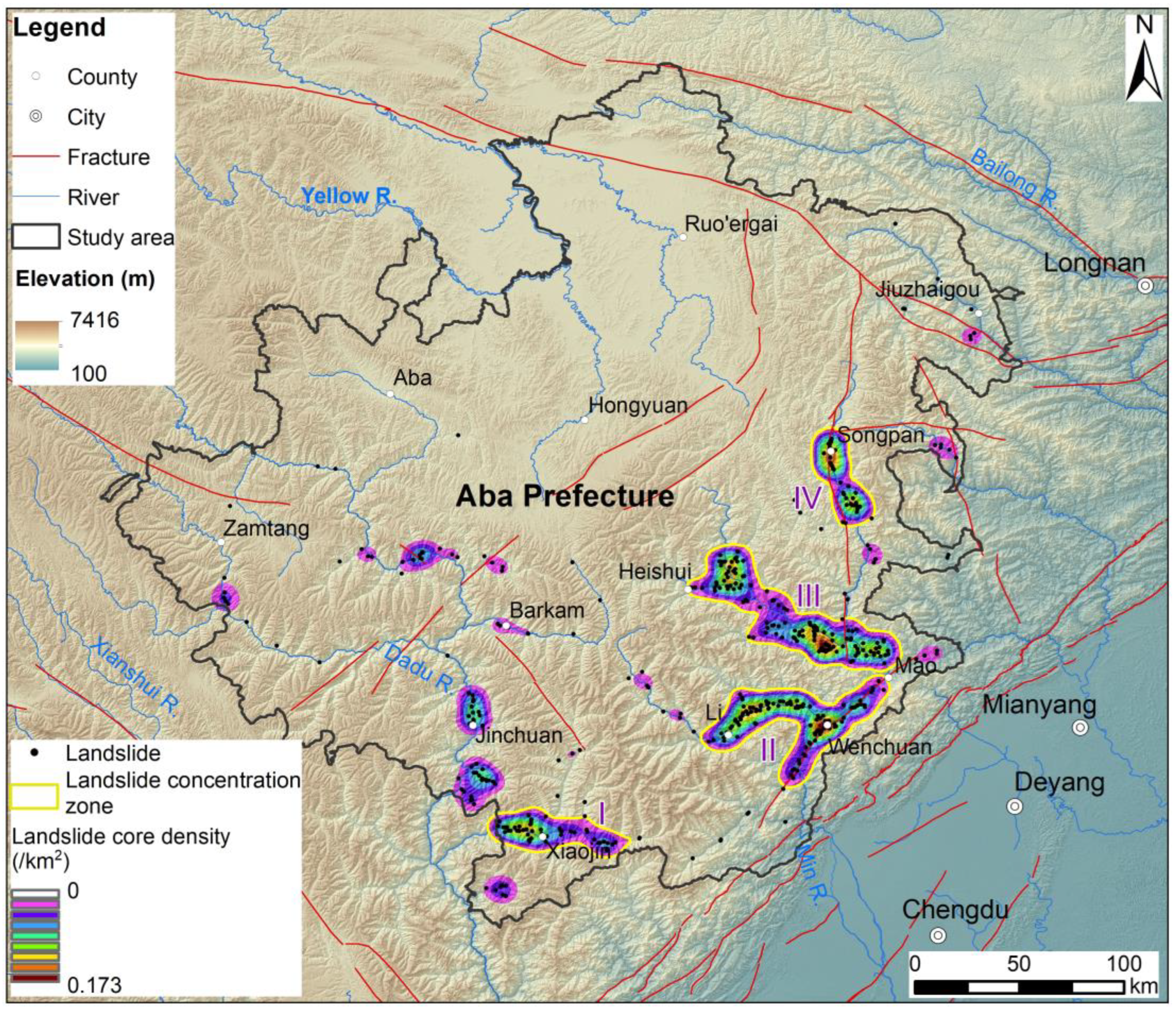
2. Study Area
3. Data and Methods
3.1. Identification of Slow-Moving Landslide
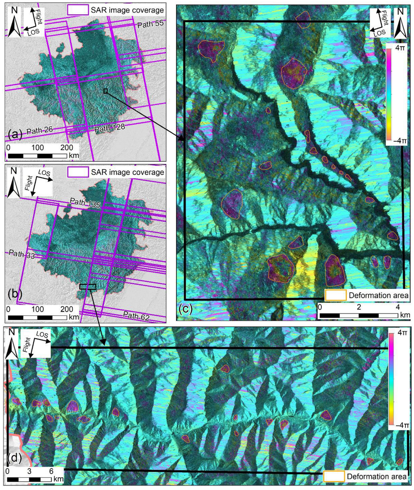
3.1.1. Deformation Detection with InSAR Technology
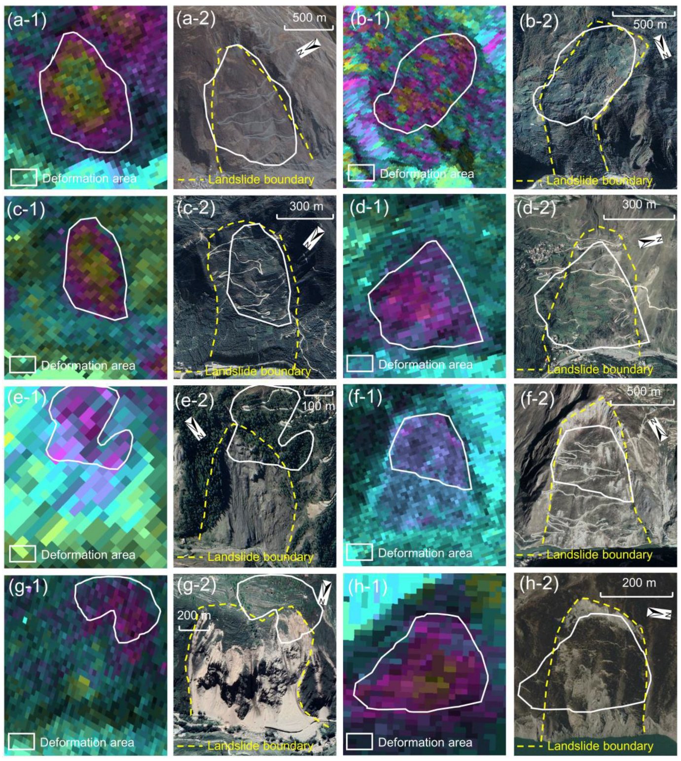
3.1.2. Landslide Mapping Based on Optical Satellite Images
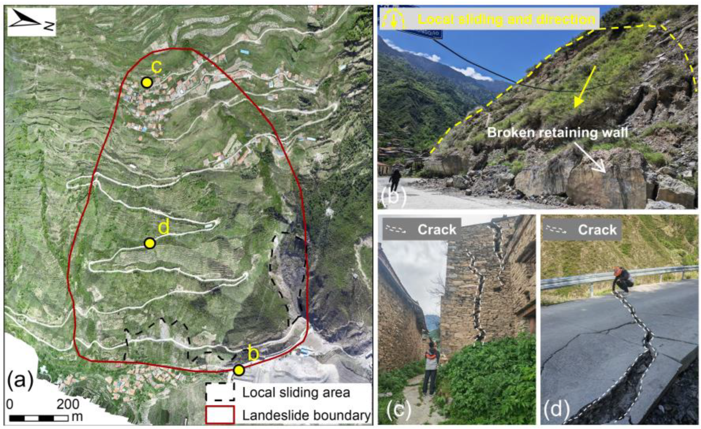
3.1.3. Field Investigation
- (1)
- Identifying deformation features of the landslide, such as local sliding failures and surface cracks (Figure 5b).
- (2)
- Evaluating infrastructure damage, including its impact on residential areas and transportation networks (Figure 5c,d).
- (3)
- Assessing the effectiveness of existing landslide control measures, such as drainage systems and stabilization works (Figure 5b).
3.2. Analysis of Influencing Factors
4. Results
4.1. Result of Slow-Moving Landslides Catalogue
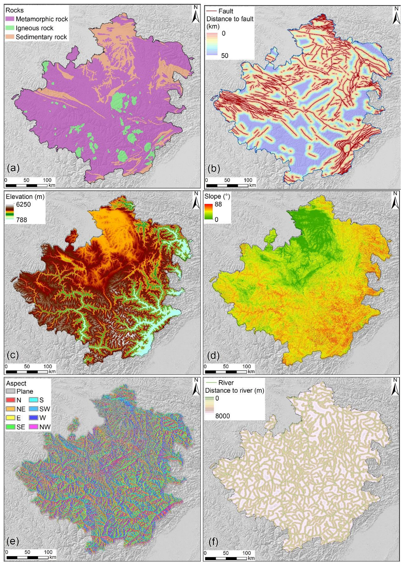
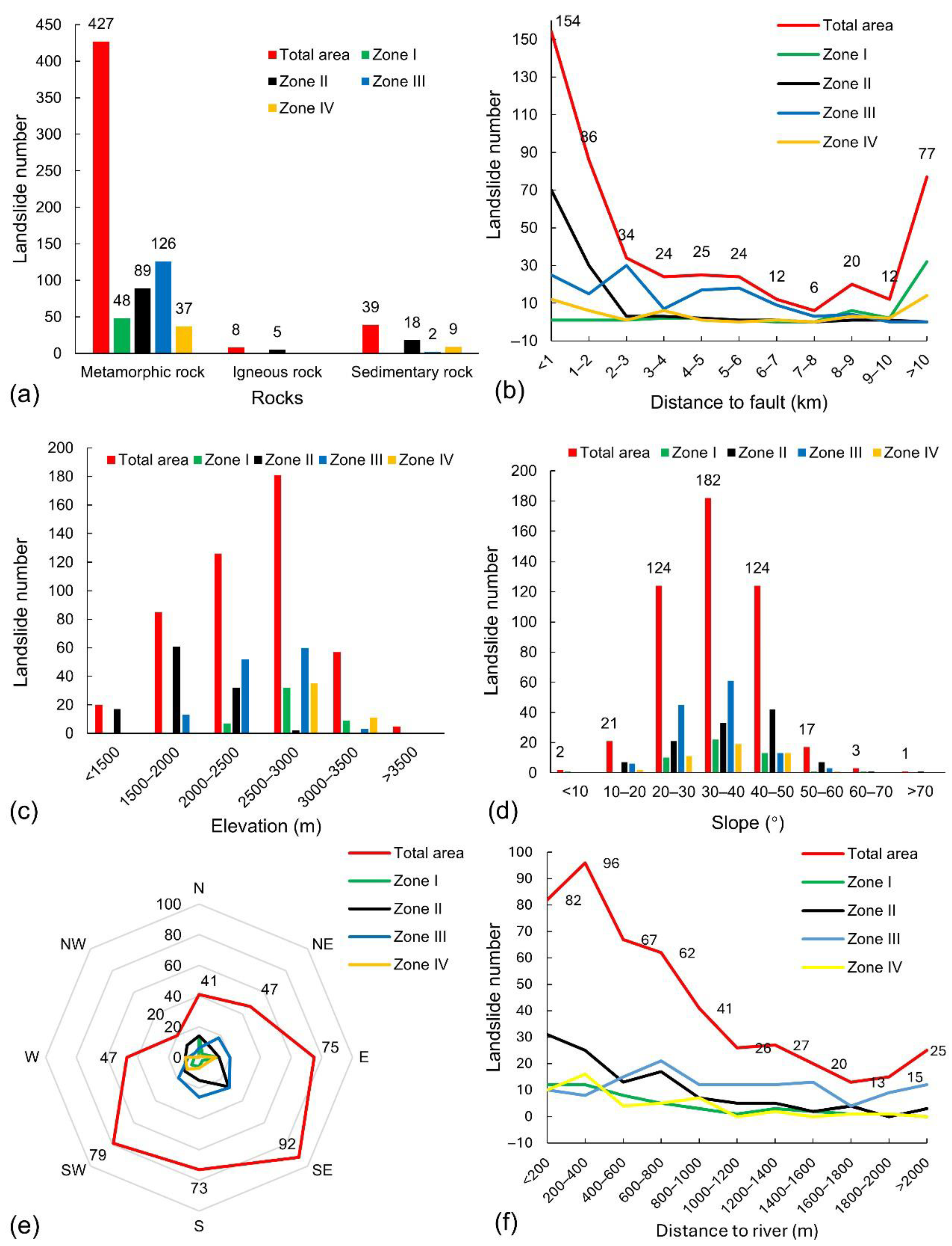
4.2. Influencing Factors of Landslide Distribution
4.2.1. Influence of Lithology
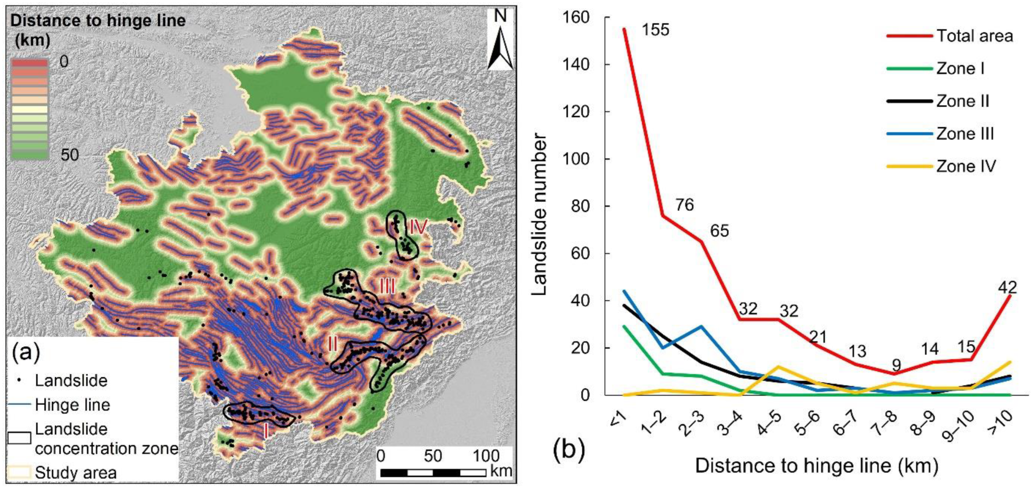
4.2.2. Influence of Fault
4.2.3. Influence of Topography and River
5. Discussion
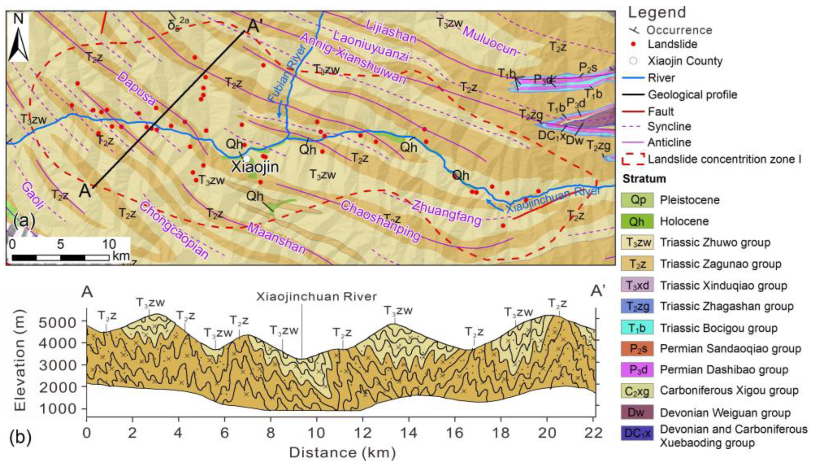
5.1. Structural Controls on Landslides in Zone I
5.2. Importance of Slow-Moving Landslides Identification for Disaster Risk Reduction
6. Conclusions
Author Contributions
Funding
Data Availability Statement
Conflicts of Interest
References
- Huang, R.; Fan, X. The landslide story. Nat. Geosci. 2013, 6, 325–326. [Google Scholar] [CrossRef]
- Hungr, O.; Leroueil, S.; Picarelli, L. The Varnes classification of landslide types, an update. Landslides 2013, 11, 167–194. [Google Scholar] [CrossRef]
- Allen, S.K.; Rastner, P.; Arora, M.; Huggel, C.; Stoffel, M. Lake outburst and debris flow disaster at Kedarnath, June 2013: Hydrometeorological triggering and topographic predisposition. Landslides 2015, 13, 1479–1491. [Google Scholar] [CrossRef]
- Froude, M.J.; Petley, D.N. Global fatal landslide occurrence from 2004 to 2016. Nat. Hazards Earth Syst. Sci. 2018, 18, 2161–2181. [Google Scholar] [CrossRef]
- Huang, R. Large-scale landslides and their sliding mechanisms in China since the 20th century. Chin. J. Rock Mech. Eng. 2007, 3, 12. [Google Scholar]
- Zhang, S.; Li, C.; Peng, J.; Zhou, Y.; Wang, S.; Chen, Y.; Tang, Y. Fatal landslides in China from 1940 to 2020: Occurrences and vulnerabilities. Landslides 2023, 20, 1243–1264. [Google Scholar] [CrossRef]
- Xu, Q. Understanding and Consideration of Related Issues in Early Identification of Potential Geohazards. Geomat. Inf. Sci. Wuhan Univ. 2020, 45, 1651–1659. [Google Scholar] [CrossRef]
- Ge, D.; Dai, K.; Guo, Z.; Li, Z. Early Identification of Serious Geological Hazards with Integrated Remote Sensing Technologies: Thoughts and Recommendations. Geomat. Inf. Sci. Wuhan Univ. 2019, 7, 949–956. [Google Scholar] [CrossRef]
- Palmer, J. Creeping earth could hold secret to deadly landslides. Nature 2017, 548, 384–386. [Google Scholar] [CrossRef]
- Lacroix, P.; Handwerger, A.L.; Bièvre, G. Life and death of slow-moving landslides. Nat. Rev. Earth Environ. 2020, 1, 404–419. [Google Scholar] [CrossRef]
- Fan, X.; Xu, Q.; Alonso-Rodriguez, A.; Subramanian, S.S.; Li, W.; Zheng, G.; Dong, X.; Huang, R. Successive landsliding and damming of the Jinsha River in eastern Tibet, China: Prime investigation, early warning, and emergency response. Landslides 2019, 16, 1003–1020. [Google Scholar] [CrossRef]
- Veveakis, E.; Vardoulakis, I.; Di Toro, G. Thermoporomechanics of creeping landslides: The 1963 Vaiont slide, northern Italy. J. Geophys. Res. Earth Surf. 2007, 112, F03026. [Google Scholar] [CrossRef]
- Xu, Q.; Dong, X.; Li, W. Integrated Space-Air-Ground Early Detection, Monitoring and Warning System for Potential Catastrophic Geohazards. Geomat. Inf. Sci. Wuhan Univ. 2019, 7, 957–966. [Google Scholar] [CrossRef]
- Yin, Y.; Sun, P.; Zhang, M.; Li, B. Mechanism on apparent dip sliding of oblique inclined bedding rockslide at Jiweishan, Chongqing, China. Landslides 2010, 8, 49–65. [Google Scholar] [CrossRef]
- Zhou, J.; Fan, G.; Chen, Q.; Yang, X. Comprehensive analyses of initiation and failure mechanisms of the 2017 Xinmo catastrophic rockslide. J. Mt. Sci. 2022, 19, 1525–1540. [Google Scholar] [CrossRef]
- Wagner, A. A new approach for geo-monitoring using modern total stations and RGB + D images. Measurement 2016, 82, 64–74. [Google Scholar] [CrossRef]
- Huang, G.; Du, S.; Wang, D. GNSS techniques for real-time monitoring of landslides: A review. Satell. Navig. 2023, 4, 5. [Google Scholar] [CrossRef]
- Klimeš, J.; Rowberry, M.D.; Blahůt, J.; Briestenský, M.; Hartvich, F.; Košťák, B.; Rybář, J.; Stemberk, J.; Štěpančíková, P. The monitoring of slow-moving landslides and assessment of stabilisation measures using an optical–mechanical crack gauge. Landslides 2011, 9, 407–415. [Google Scholar] [CrossRef]
- Zhang, Y.; Tang, H.; Li, C.; Lu, G.; Cai, Y.; Zhang, J.; Tan, F. Design and Testing of a Flexible Inclinometer Probe for Model Tests of Landslide Deep Displacement Measurement. Sensors 2018, 18, 224. [Google Scholar] [CrossRef]
- Malet, J.P.; Maquaire, O.; Calais, E. The use of Global Positioning System techniques for the continuous monitoring of landslides; application to the Super-Sauze earthflow (Alpes-de-Haute-Provence, France). Geomorphology 2002, 1–2, 33–54. [Google Scholar] [CrossRef]
- Liu, X.; Zhao, C.; Zhang, Q.; Lu, Z.; Li, Z.; Yang, C.; Zhu, W.; Liu-Zeng, J.; Chen, L.; Liu, C. Integration of Sentinel-1 and ALOS/PALSAR-2 SAR datasets for mapping active landslides along the Jinsha River corridor, China. Eng. Geol. 2021, 284, 106033. [Google Scholar] [CrossRef]
- Xu, Q.; Zhao, B.; Dai, K.; Dong, X.; Li, W.; Zhu, X.; Yang, Y.; Xiao, X.; Wang, X.; Huang, J.; et al. Remote sensing for landslide investigations: A progress report from China. Eng. Geol. 2023, 321, 107156. [Google Scholar] [CrossRef]
- Scaioni, M.; Longoni, L.; Melillo, V.; Papini, M. Remote Sensing for Landslide Investigations: An Overview of Recent Achievements and Perspectives. Remote Sens. 2014, 10, 9600–9653. [Google Scholar] [CrossRef]
- Li, W.; Zhan, W.; Lu, H.; Xu, Q.; Pei, X.; Wang, D.; Huang, R.; Ge, D. Precursors to large rockslides visible on optical remote-sensing images and their implications for landslide early detection. Landslides 2023, 20, 1–12. [Google Scholar] [CrossRef]
- Schlögl, M.; Gutjahr, K.; Fuchs, S. The challenge to use multi-temporal InSAR for landslide early warning. Nat. Hazards 2022, 112, 2913–2919. [Google Scholar] [CrossRef]
- Ferretti, A.; Fumagalli, A.; Novali, F.; Prati, C.; Rocca, F.; Rucci, A. A New Algorithm for Processing Interferometric Data-Stacks: SqueeSAR. IEEE Trans. Geosci. Remote Sens. 2011, 49, 3460–3470. [Google Scholar] [CrossRef]
- Hooper, A.; Zebker, H.; Segall, P.; Kampes, B. A new method for measuring deformation on volcanoes and other natural terrains using InSAR persistent scatterers. Geophys. Res. Lett. 2004, 31, L23611. [Google Scholar] [CrossRef]
- Sandwell, D.T.; Price, E.J. Phase gradient approach to stacking interferograms. J. Geophys. Res. Solid Earth 1998, 103, 30183–30204. [Google Scholar] [CrossRef]
- Carlà, T.; Intrieri, E.; Raspini, F.; Bardi, F.; Farina, P.; Ferretti, A.; Colombo, D.; Novali, F.; Casagli, N. Perspectives on the prediction of catastrophic slope failures from satellite InSAR. Sci. Rep. 2019, 9, 14137. [Google Scholar] [CrossRef]
- Intrieri, E.; Raspini, F.; Fumagalli, A.; Lu, P.; Del Conte, S.; Farina, P.; Allievi, J.; Ferretti, A.; Casagli, N. The Maoxian landslide as seen from space: Detecting precursors of failure with Sentinel-1 data. Landslides 2018, 15, 123–133. [Google Scholar] [CrossRef]
- Li, Z.; Liu, Y.; Zhou, X.; Cross, P.; Feng, W. Using small baseline Interferometric SAR to map nonlinear ground motion: A case study in Northern Tibet. J. Appl. Geod. 2009, 3, 163–170. [Google Scholar] [CrossRef]
- Lu, H.; Li, W.; Xu, Q.; Yu, W.; Zhou, S.; Li, Z.; Zhan, W.; Li, W.; Xu, S.; Zhang, P.; et al. Active landslide detection using integrated remote sensing technologies for a wide region and multiple stages: A case study in southwestern China. Sci. Total Environ. 2024, 931, 172709. [Google Scholar] [CrossRef]
- Zhou, S.; Chen, B.; Lu, H.; Shan, Y.; Li, Z.; Li, P.; Cao, X.; Li, W. Analysis of the Spatial Distribution and Deformation Types of Active Landslides in the Upper Jinsha River, China, Using Integrated Remote Sensing Technologies. Remote Sens. 2023, 16, 100. [Google Scholar] [CrossRef]
- Pu, C.; Xu, Q.; Wang, X.; Li, Z.; Chen, W.; Zhao, K.; Xiu, D.; Liu, J. Refined mapping and kinematic trend assessment of potential landslides associated with large-scale land creation projects with multitemporal InSAR. Int. J. Appl. Earth Obs. Geoinf. 2023, 118, 103266. [Google Scholar] [CrossRef]
- Shao, X.; Ma, S.; Xu, C.; Cheng, J.; Xu, X. Seismically-induced landslide probabilistic hazard mapping of Aba Prefecture and Chengdu Plain region, Sichuan Province, China for future seismic scenarios. Geosci. Lett. 2023, 10, 55. [Google Scholar] [CrossRef]
- Zhou, J.; Jiang, N.; Li, H. Automatic discontinuity identification and quantitative monitoring of unstable blocks using terrestrial laser scanning in large landslide during emergency disposal. Landslides 2024, 21, 607–620. [Google Scholar] [CrossRef]
- Li, M.; Zhang, L.; Dong, J.; Tang, M.; Shi, X.; Liao, M.; Xu, Q. Characterization of pre- and post-failure displacements of the Huangnibazi landslide in Li County with multi-source satellite observations. Eng. Geol. 2019, 257, 105140. [Google Scholar] [CrossRef]
- Wang, D.; Liu, M.; Zhu, X.; Ma, H.; Cheng, Q.; Zhu, M.; Chen, Z.; Ouyang, C. Failure mechanisms and deformation processes of a high-locality landslide at Tonghua Town, Li County, China, 2017. Landslides 2019, 17, 165–177. [Google Scholar] [CrossRef]
- Yang, H.; Xing, B.; He, J.; Cheng, Q.; Wang, F. The kinematic characterization of a rockfall in Zagunao Valley in the eastern margin of the Tibetan Plateau. Landslides 2022, 20, 601–614. [Google Scholar] [CrossRef]
- Gao, Z.; Liu, X.; Ding, M.; Hassan, M.; Yang, G.; She, T. Detailed investigation and movement process analysis of typical high-locality landslide in dry season: A case of Qingliu landslide. Landslides 2023, 20, 1943–1959. [Google Scholar] [CrossRef]
- Li, Y.; Huang, S.; Tang, P.; Wang, Y.; Scaringi, G.; Liu, E.; Meng, M.; Qin, L. Successive landsliding on the G213 National Highway, a section of the Sichuan-Qinghai traffic corridor (May 10, 2023, Songpan County, Sichuan, China). Landslides 2024, 21, 669–677. [Google Scholar] [CrossRef]
- Wang, W.; Yin, Y.; Yang, L.; Zhang, N.; Wei, Y. Investigation and dynamic analysis of the catastrophic rockslide avalanche at Xinmo, Maoxian, after the Wenchuan Ms 8.0 earthquake. Bull. Eng. Geol. Environ. 2020, 79, 495–512. [Google Scholar] [CrossRef]
- Xu, Q.; Li, W.; Dong, X.; Xiao, X.; Fan, X.; Pei, X. The Xinmocun landslide on June 24, 2017 in Maoxian, Sichuan: Characteristics and failure mechanism. Chin. J. Rock Mech. Eng. 2017, 11, 2612–2628. [Google Scholar] [CrossRef]
- Zhou, Y.; Zhao, X.; Zhang, J.; Meng, M. Identification of a locking segment in a high-locality landslide in Shidaguan, Southwest China. Nat. Hazards 2022, 111, 2909–2931. [Google Scholar] [CrossRef]
- Shan, Y.; Xu, Z.; Zhou, S.; Lu, H.; Yu, W.; Li, Z.; Cao, X.; Li, P.; Li, W. Landslide Hazard Assessment Combined with InSAR Deformation: A Case Study in the Zagunao River Basin, Sichuan Province, Southwestern China. Remote Sens. 2023, 16, 99. [Google Scholar] [CrossRef]
- Ren, J.; Xu, X.; Zhang, S.; Yeats, R.S.; Chen, J.; Zhu, A.; Liu, S. Surface rupture of the 1933 M 7.5 Diexi earthquake in eastern Tibet: Implications for seismogenic tectonics. Geophys. J. Int. 2018, 212, 1627–1644. [Google Scholar] [CrossRef]
- Yin, Y.; Wang, F.; Sun, P. Landslide hazards triggered by the 2008 Wenchuan earthquake, Sichuan, China. Landslides 2009, 6, 139–152. [Google Scholar] [CrossRef]
- Hubbard, J.; Shaw, J.H. Uplift of the Longmen Shan and Tibetan plateau, and the 2008 Wenchuan (M = 7.9) earthquake. Nat. Geosci. 2009, 458, 194–197. [Google Scholar] [CrossRef]
- Lin, X.; Chu, R.; Zeng, X. Rupture processes and Coulomb stress changes of the 2017 Mw 6.5 Jiuzhaigou and 2013 Mw 6.6 Lushan earthquakes. Earth Planets Space 2019, 71, 81. [Google Scholar] [CrossRef]
- Liang, J.; Dong, J.; Zhang, S.; Zhao, C.; Liu, B.; Yang, L.; Yan, S.; Ma, X. Discussion on InSAR Identification Effectivity of Potential Landslides and Factors That Influence the Effectivity. Remote Sens. 2022, 14, 1952. [Google Scholar] [CrossRef]
- Zhang, L.; Dai, K.; Deng, J.; Ge, D.; Liang, R.; Li, W.; Xu, Q. Identifying Potential Landslides by Stacking-InSAR in Southwestern China and Its Performance Comparison with SBAS-InSAR. Remote Sens. 2021, 13, 3662. [Google Scholar] [CrossRef]
- Guo, Q.; Tong, L.; Wang, H. A Monitoring Method Based on Vegetation Abnormal Information Applied to the Case of Jizong Shed-Tunnel Landslide. Remote Sens. 2022, 14, 5640. [Google Scholar] [CrossRef]
- Wang, H.; Guo, Q.; Ge, X.; Tong, L. A Spatio-Temporal Monitoring Method Based on Multi-Source Remote Sensing Data Applied to the Case of the Temi Landslide. Land 2022, 11, 1367. [Google Scholar] [CrossRef]
- Guo, X.; Guo, Q.; Feng, Z. Relationship between landslide creep and vegetation anomalies in remote sensing images. Natl. Remote Sens. Bull. 2020, 24, 776–786. [Google Scholar] [CrossRef]
- Nichol, J.; Wong, M.S. Satellite remote sensing for detailed landslide inventories using change detection and image fusion. Int. J. Remote Sens. 2007, 26, 1913–1926. [Google Scholar] [CrossRef]
- Hong, H.; Pourghasemi, H.R.; Pourtaghi, Z.S. Landslide susceptibility assessment in Lianhua County (China): A comparison between a random forest data mining technique and bivariate and multivariate statistical models. Geomorphology 2016, 259, 105–118. [Google Scholar] [CrossRef]
- Süzen, M.L.; Kaya, B.Ş. Evaluation of environmental parameters in logistic regression models for landslide susceptibility mapping. Int. J. Digit. Earth 2012, 5, 338–355. [Google Scholar] [CrossRef]
- Fossen, H. Structural Geology; Cambridge University Press: Cambridge, UK, 2016. [Google Scholar]
- Roger, F.; Jolivet, M.; Malavieille, J. The tectonic evolution of the Songpan-Garzê (North Tibet) and adjacent areas from Proterozoic to Present: A synthesis. J. Asian Earth Sci. 2010, 39, 254–269. [Google Scholar] [CrossRef]


| Orbit Direction | Path | Frame | Collection Date | Scenes |
|---|---|---|---|---|
| Ascending | 26 | 93/98/103 | 1 October 2020–1 November 2023 | 258 |
| 128 | 94/99/104/109 | 6 October 2020–27 October 2023 | 332 | |
| 55 | 102/107 | 1 October 2020–22 October 2023 | 133 | |
| Descending | 33 | 482 | 11 October 2020–20 October 2023 | 91 |
| 135 | 478/483/488 | 6 October 2020–27 October 2023 | 255 | |
| 62 | 479/484/489 | 1 October 2020–22 October 2023 | 368 |
| Zone | Area (km2) | Number | Percentage of Total Landslides | Average Density (/103 km2) | Mean Area (×104 m2) | Mean Height (m) |
|---|---|---|---|---|---|---|
| Zone I | 822.5 | 48 | 10.1% | 58.4 | 44.1 | 448 |
| Zone II | 1643.3 | 112 | 23.6% | 68.2 | 26.8 | 439 |
| Zone III | 1931.0 | 128 | 27.0% | 66.3 | 46.7 | 465 |
| Zone IV | 656.2 | 46 | 9.7% | 70.1 | 6.4 | 130 |
| Others | 78,041.9 | 140 | 29.5% | 1.8 | 25.7 | 361 |
| Total area | 83,095.0 | 474 | 100% | 5.7 | 31.6 | 394 |
Disclaimer/Publisher’s Note: The statements, opinions and data contained in all publications are solely those of the individual author(s) and contributor(s) and not of MDPI and/or the editor(s). MDPI and/or the editor(s) disclaim responsibility for any injury to people or property resulting from any ideas, methods, instructions or products referred to in the content. |
© 2025 by the authors. Licensee MDPI, Basel, Switzerland. This article is an open access article distributed under the terms and conditions of the Creative Commons Attribution (CC BY) license (https://creativecommons.org/licenses/by/4.0/).
Share and Cite
Ren, J.; Yang, W.; Ma, Z.; Li, W.; Zeng, S.; Fu, H.; Wen, Y.; He, J. Remote Sensing-Based Detection and Analysis of Slow-Moving Landslides in Aba Prefecture, Southwest China. Remote Sens. 2025, 17, 1462. https://doi.org/10.3390/rs17081462
Ren J, Yang W, Ma Z, Li W, Zeng S, Fu H, Wen Y, He J. Remote Sensing-Based Detection and Analysis of Slow-Moving Landslides in Aba Prefecture, Southwest China. Remote Sensing. 2025; 17(8):1462. https://doi.org/10.3390/rs17081462
Chicago/Turabian StyleRen, Juan, Wunian Yang, Zhigang Ma, Weile Li, Shuai Zeng, Hao Fu, Yan Wen, and Jiayang He. 2025. "Remote Sensing-Based Detection and Analysis of Slow-Moving Landslides in Aba Prefecture, Southwest China" Remote Sensing 17, no. 8: 1462. https://doi.org/10.3390/rs17081462
APA StyleRen, J., Yang, W., Ma, Z., Li, W., Zeng, S., Fu, H., Wen, Y., & He, J. (2025). Remote Sensing-Based Detection and Analysis of Slow-Moving Landslides in Aba Prefecture, Southwest China. Remote Sensing, 17(8), 1462. https://doi.org/10.3390/rs17081462