
Comprehensive Assessment of Nine Fine-Resolution Global Forest Cover Products in the Three-North Shelter Forest Program Region


Abstract
1. Introduction
2. Study Area and Datasets
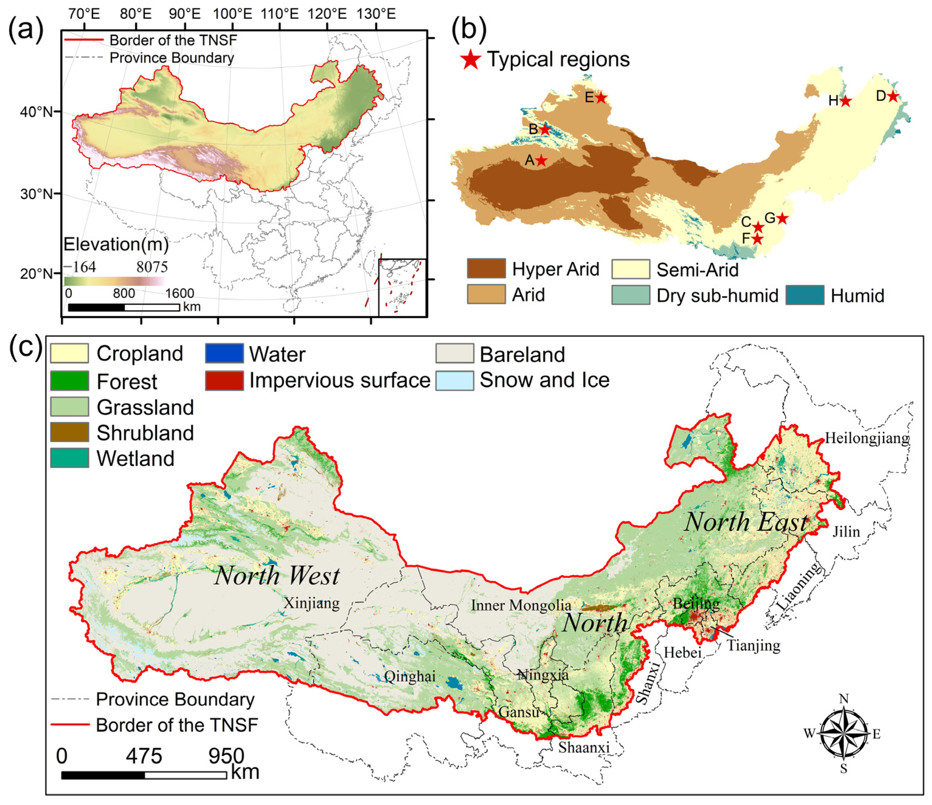
2.1. Three-North Shelter Forest Region
2.2. Nine Global 10–30 m Forest Products
2.3. Forest Inventory Statistical Data
2.4. Climate Zone Data
3. Materials and Methods
3.1. Generating Validation Dataset from the Multi-Sourced Products
3.2. The Harmonization of Multi-Sourced Global Forest Products
3.3. Consistency Analysis and Accuracy Assessment
4. Results
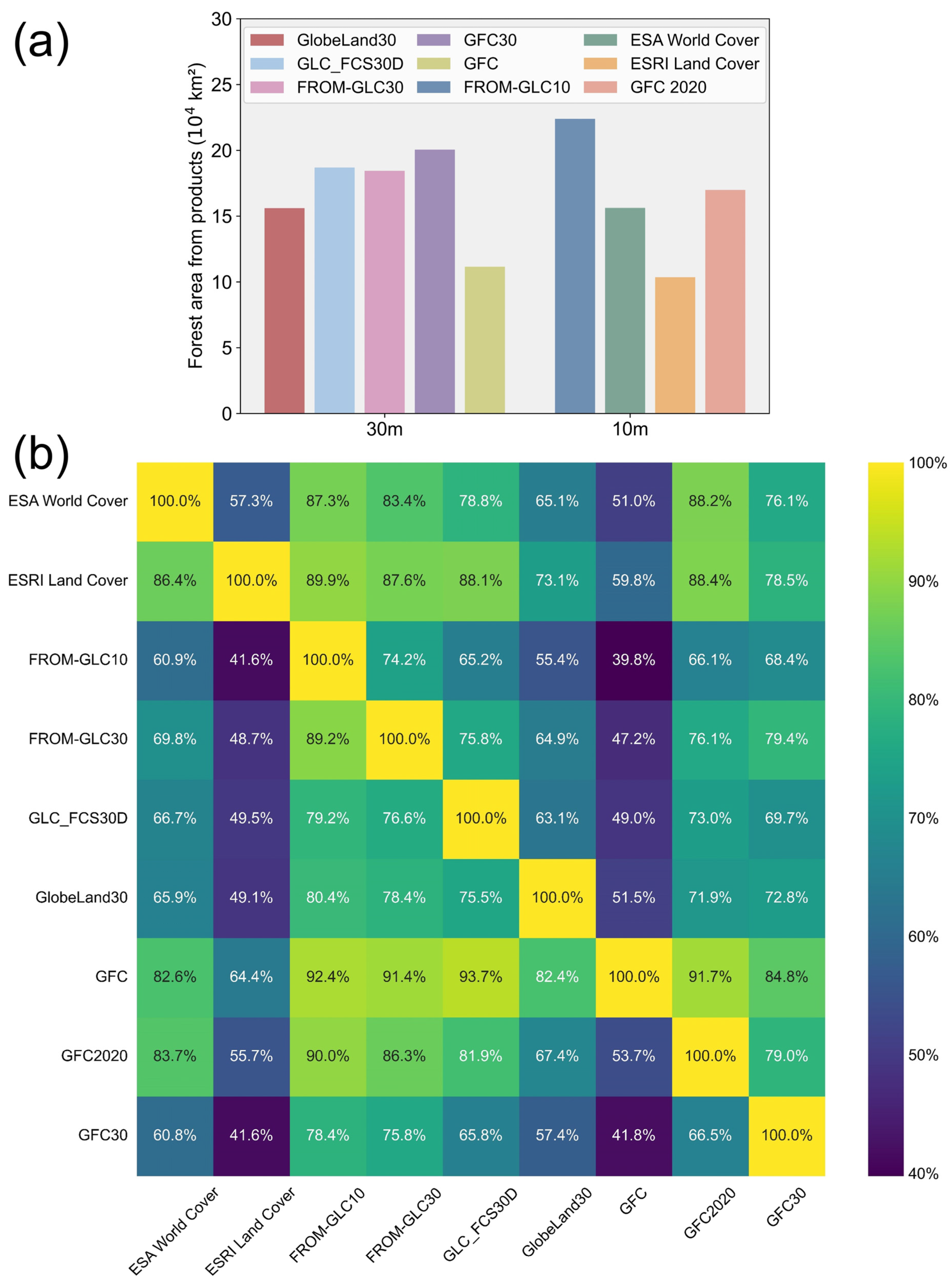
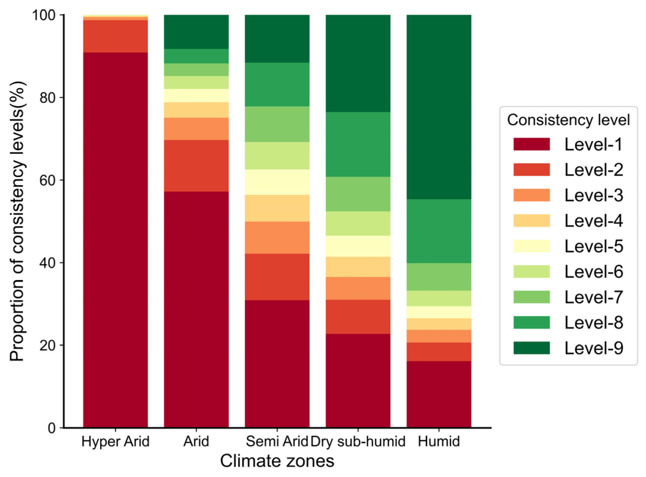
4.1. Area-Based Consistency Analysis of Multiple Products
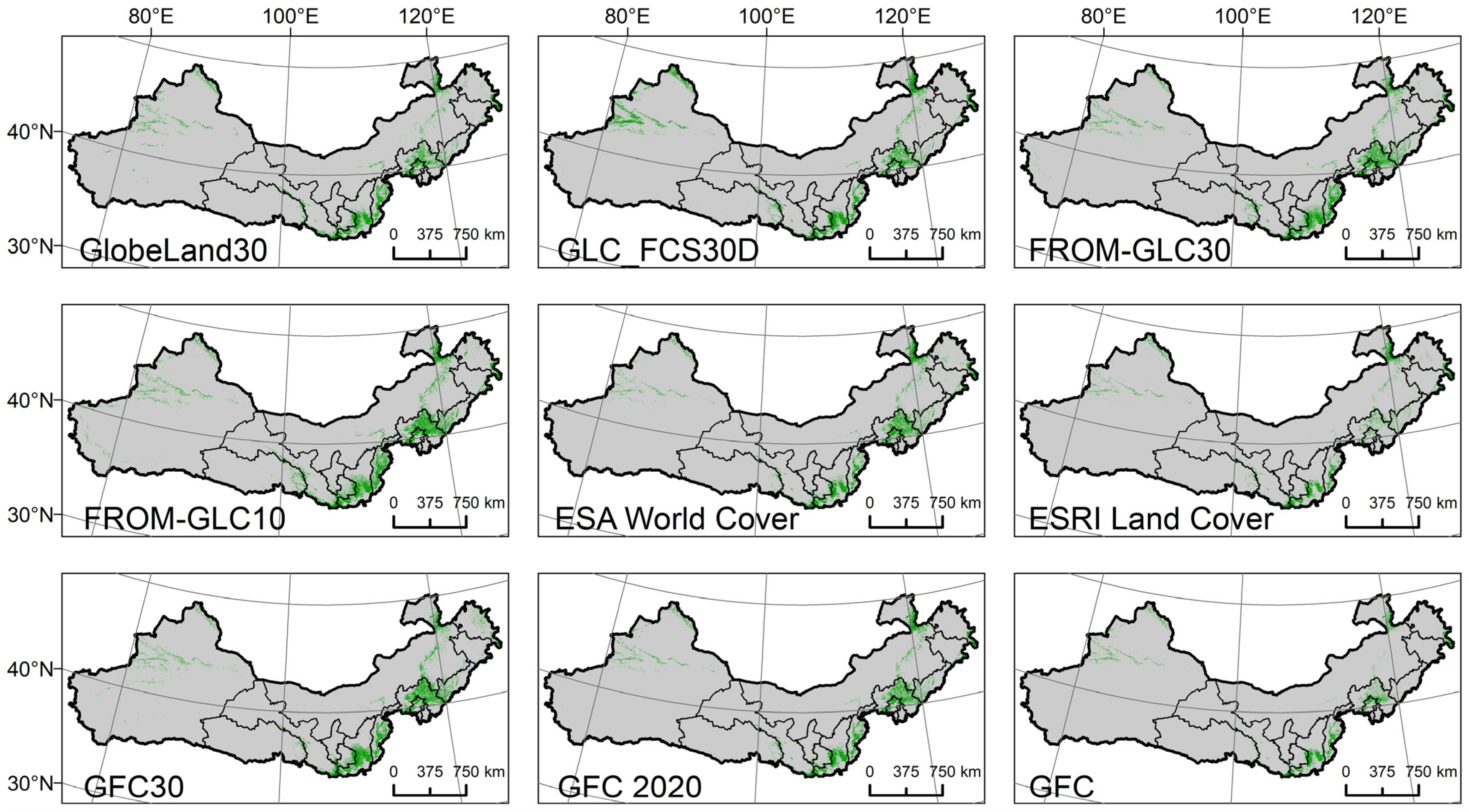
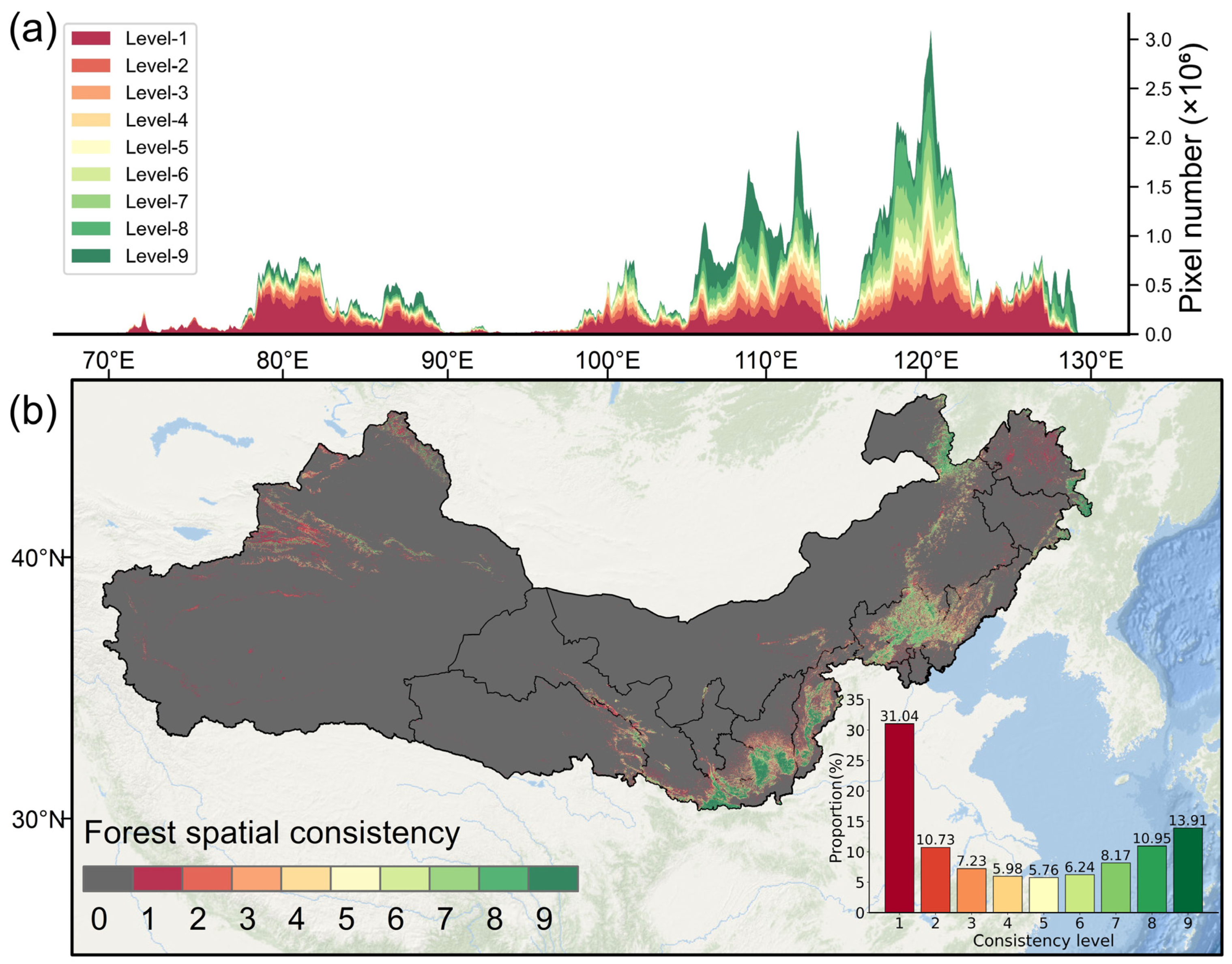
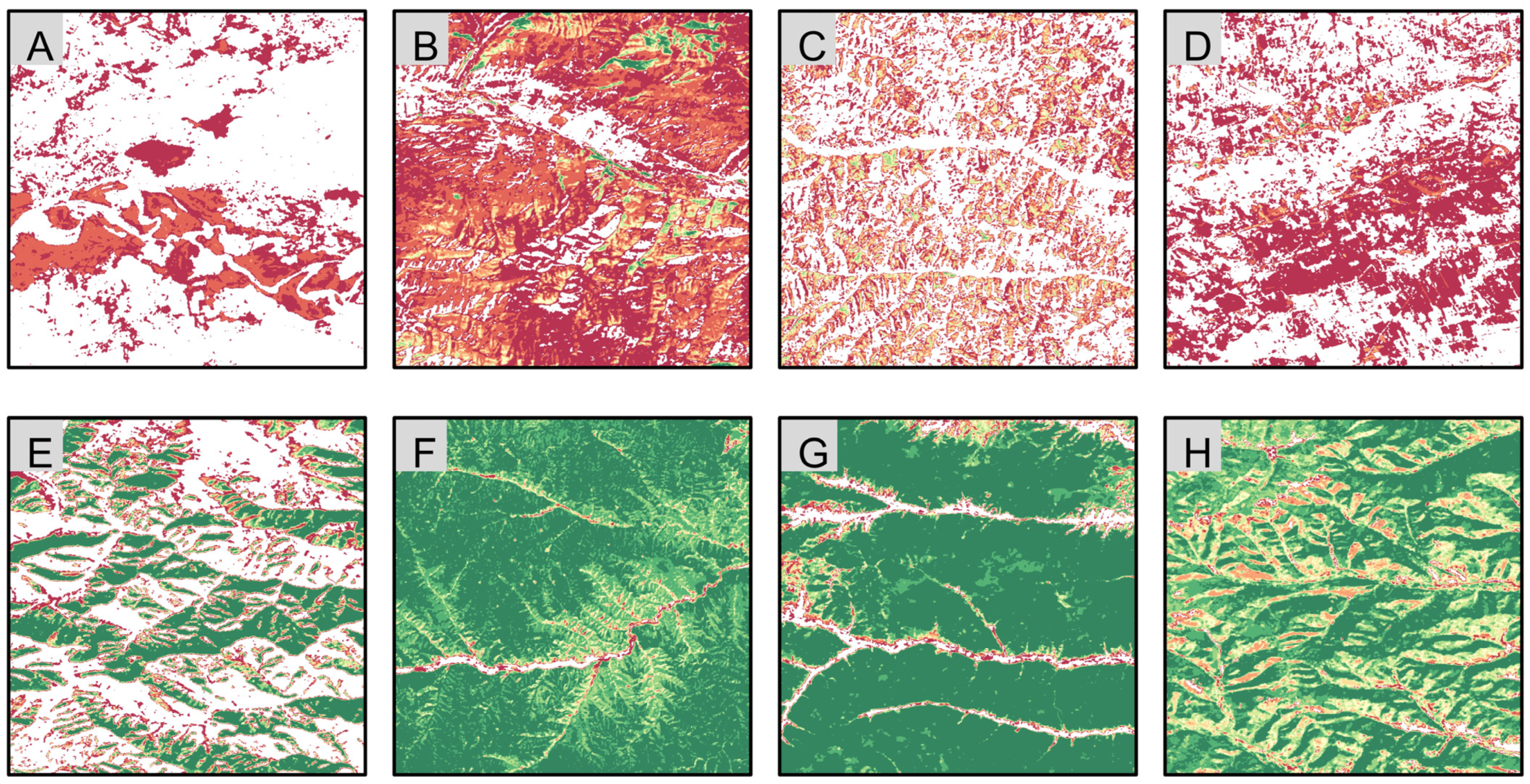
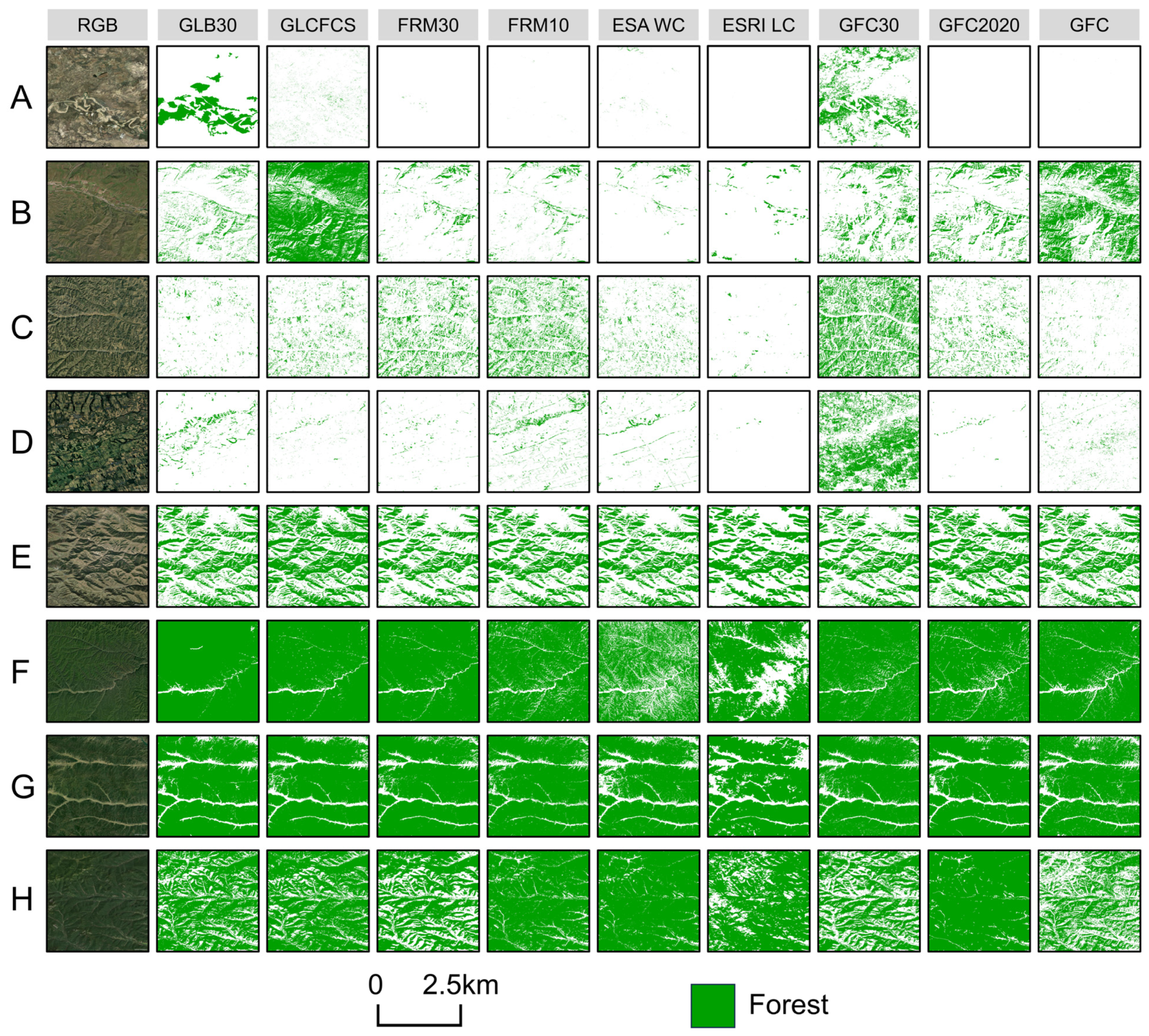
4.2. Spatial Consistency Analysis of Nine Products
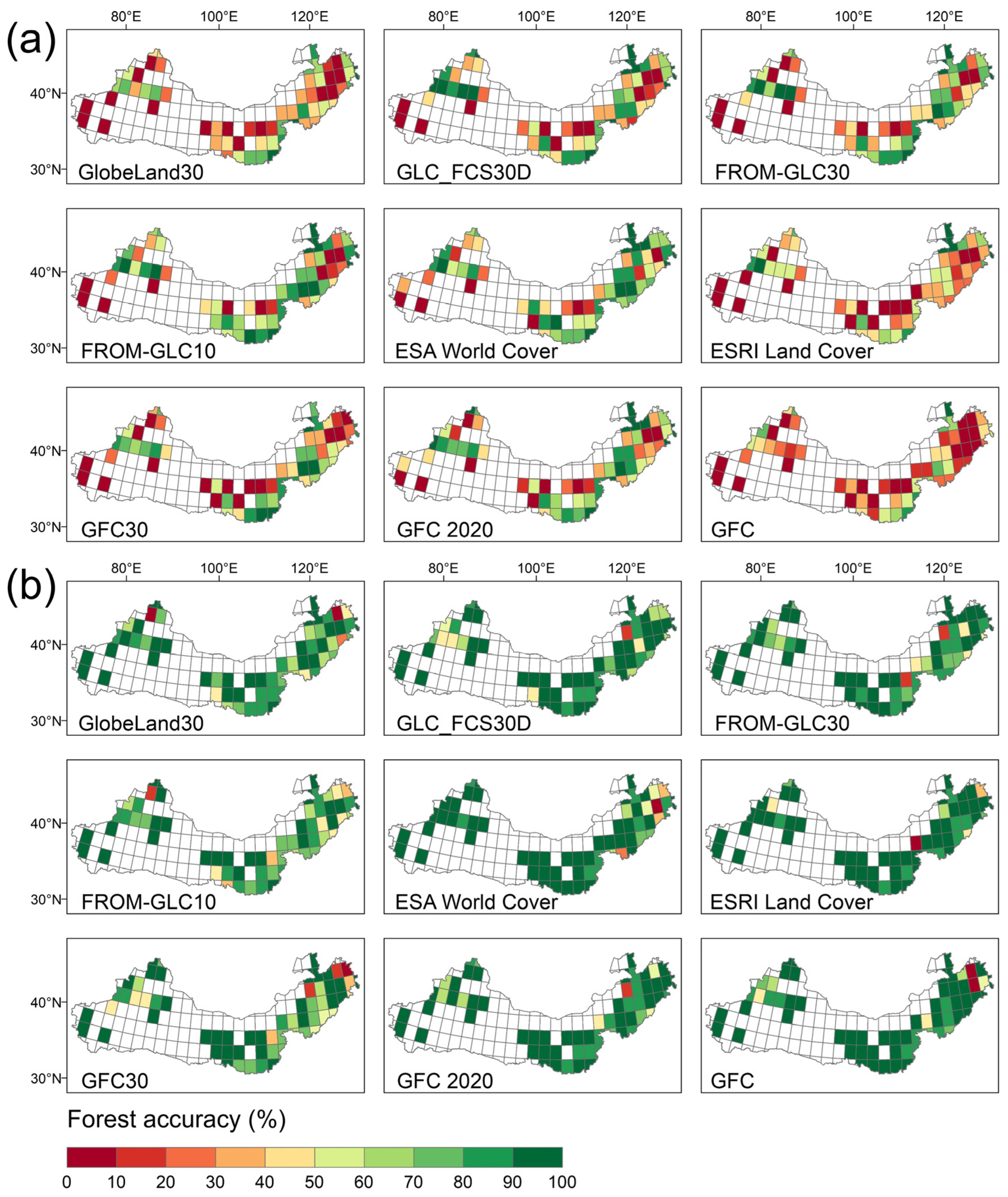
4.3. Accuracy Assessment of the Nine Products
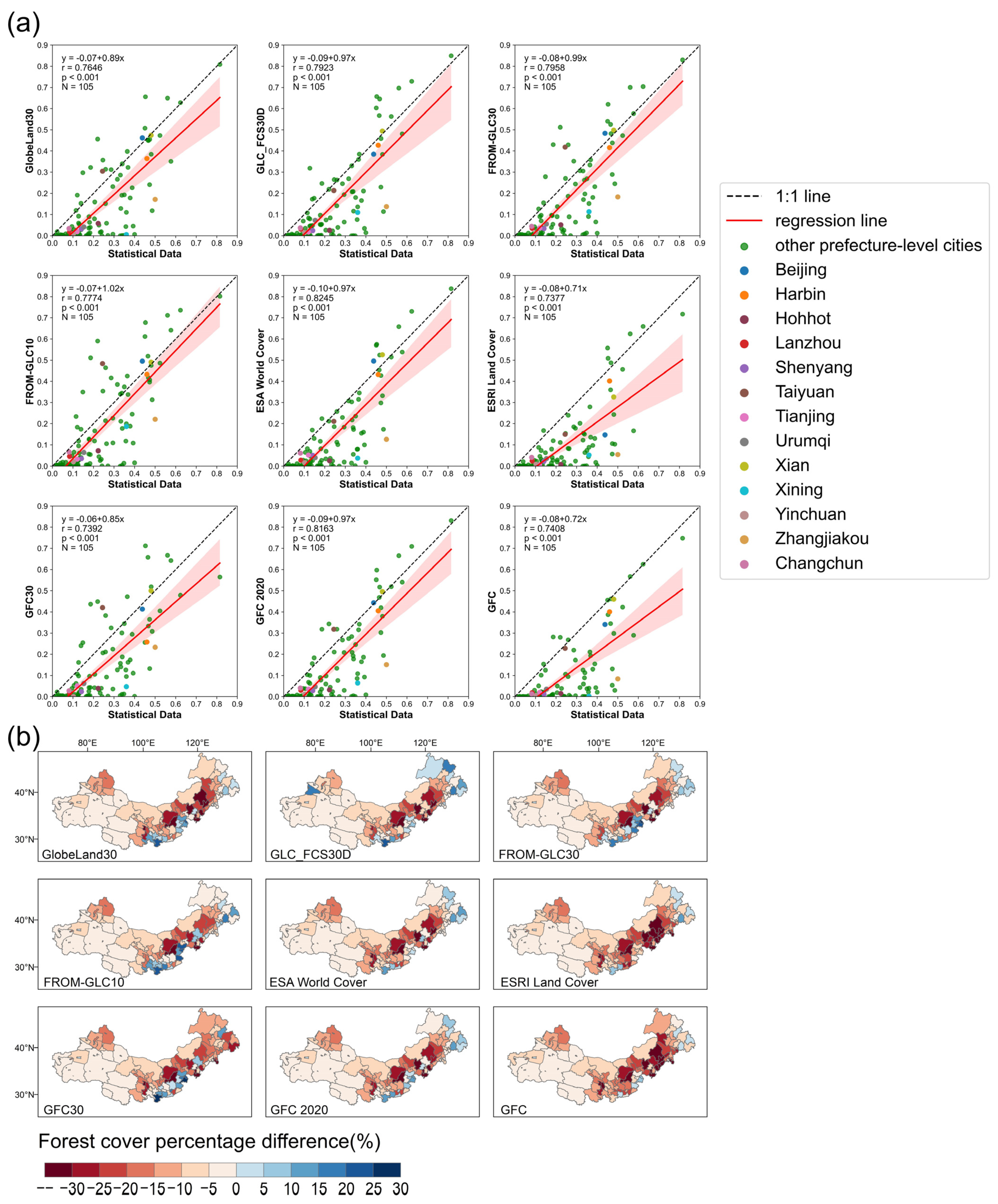
4.4. Comparison Between Statistical Data and Global Forest Cover Products
5. Discussion
5.1. Reasons for Discrepancies Among Forest Products
5.2. Differences Between Forest Cover Products and Statistical Data
5.2.1. Underestimation of Forest Cover Products in Arid Regions
5.2.2. Differences from the Forest Definition in the Forest Resources Survey
6. Conclusions
Supplementary Materials
Author Contributions
Funding
Data Availability Statement
Acknowledgments
Conflicts of Interest
References
- Keenan, R.J.; Reams, G.A.; Achard, F.; de Freitas, J.V.; Grainger, A.; Lindquist, E. Dynamics of global forest area: Results from the FAO Global Forest Resources Assessment 2015. For. Ecol. Manag. 2015, 352, 9–20. [Google Scholar] [CrossRef]
- Harris, N.L.; Gibbs, D.A.; Baccini, A.; Birdsey, R.A.; De Bruin, S.; Farina, M.; Fatoyinbo, L.; Hansen, M.C.; Herold, M.; Houghton, R.A. Global maps of twenty-first century forest carbon fluxes. Nat. Clim. Change 2021, 11, 234–240. [Google Scholar] [CrossRef]
- Keenan, T.F.; Hollinger, D.Y.; Bohrer, G.; Dragoni, D.; Munger, J.W.; Schmid, H.P.; Richardson, A.D. Increase in forest water-use efficiency as atmospheric carbon dioxide concentrations rise. Nature 2013, 499, 324–327. [Google Scholar] [CrossRef]
- Nguyen, T.H.; Jones, S.D.; Soto-Berelov, M.; Haywood, A.; Hislop, S. A spatial and temporal analysis of forest dynamics using Landsat time-series. Remote Sens. Environ. 2018, 217, 461–475. [Google Scholar] [CrossRef]
- Xiao, Y.; Wang, Q.; Zhang, H.K. Global Natural and Planted Forests Mapping at Fine Spatial Resolution of 30 m. J. Remote Sens. 2024, 4, 0204. [Google Scholar] [CrossRef]
- Zhao, C.; Jia, M.; Zhang, R.; Wang, Z.; Mao, D.; Zhong, C.; Guo, X. Distribution of Mangrove Species Kandelia obovata in China Using Time-series Sentinel-2 Imagery for Sustainable Mangrove Management. J. Remote Sens. 2024, 4, 0143. [Google Scholar] [CrossRef]
- Chen, J.; Chen, J.; Liao, A.; Cao, X.; Chen, L.; Chen, X.; He, C.; Han, G.; Peng, S.; Lu, M. Global land cover mapping at 30 m resolution: A POK-based operational approach. ISPRS J. Photogramm. Remote Sens. 2015, 103, 7–27. [Google Scholar] [CrossRef]
- Gong, P.; Wang, J.; Yu, L.; Zhao, Y.; Zhao, Y.; Liang, L.; Niu, Z.; Huang, X.; Fu, H.; Liu, S. Finer resolution observation and monitoring of global land cover: First mapping results with Landsat TM and ETM+ data. Int. J. Remote Sens. 2013, 34, 2607–2654. [Google Scholar] [CrossRef]
- Zhang, X.; Zhao, T.; Xu, H.; Liu, W.; Wang, J.; Chen, X.; Liu, L. GLC_FCS30D: The first global 30 m land-cover dynamics monitoring product with a fine classification system for the period from 1985 to 2022 generated using dense-time-series Landsat imagery and the continuous change-detection method. Earth Syst. Sci. Data 2024, 16, 1353–1381. [Google Scholar] [CrossRef]
- Hansen, M.C.; Potapov, P.V.; Moore, R.; Hancher, M.; Turubanova, S.A.; Tyukavina, A.; Thau, D.; Stehman, S.V.; Goetz, S.J.; Loveland, T.R. High-resolution global maps of 21st-century forest cover change. Science 2013, 342, 850–853. [Google Scholar] [CrossRef]
- Zhang, X.; Long, T.; He, G.; Guo, Y.; Yin, R.; Zhang, Z.; Xiao, H.; Li, M.; Cheng, B. Rapid generation of global forest cover map using Landsat based on the forest ecological zones. J. Appl. Remote Sens. 2020, 14, 022211. [Google Scholar]
- Zanaga, D.; De Kerchove, R.V.; Keersmaecker, W.D.; Souverijns, N.; Brockmann, C.; Quast, R.; Wevers, J.; Grosu, A.; Paccini, A.; Vergnaud, S. ESA WorldCover 10 m 2020 v100, Version 100; The European Space Agency: Paris, France, 2021. [Google Scholar] [CrossRef]
- Gong, P.; Liu, H.; Zhang, M.; Li, C.; Wang, J.; Huang, H.; Clinton, N.; Ji, L.; Li, W.; Bai, Y. Stable classification with limited sample: Transferring a 30-m resolution sample set collected in 2015 to mapping 10-m resolution global land cover in 2017. Sci. Bull. 2019, 64, 370–373. [Google Scholar]
- Karra, K.; Kontgis, C.; Statman-Weil, Z.; Mazzariello, J.C.; Mathis, M.; Brumby, S.P. Global land use/land cover with Sentinel 2 and deep learning. In Proceedings of the 2021 IEEE International Geoscience and Remote Sensing Symposium IGARSS, Brussels, Belgium, 11–16 July 2021; pp. 4704–4707. [Google Scholar]
- Bourgoin, C.; Ameztoy, I.; Verhegghen, A.; Desclée, B.; Carboni, S.; Bastin, J.; Beuchle, R.; Brink, A.; Defourny, P.; Delhez, B. Mapping Global Forest Cover of the Year 2020 to Support the EU Regulation on Deforestation-Free Supply Chains; Publications Office of the European Union: Luxembourg, 2024. [Google Scholar]
- Kang, J.; Wang, Z.; Sui, L.; Yang, X.; Ma, Y.; Wang, J. Consistency Analysis of Remote Sensing Land Cover Products in the Tropical Rainforest Climate Region: A Case Study of Indonesia. Remote Sens. 2020, 12, 1410. [Google Scholar] [CrossRef]
- Peng, X.; He, G.; Wang, G.; Long, T.; Zhang, X.; Yin, R. User-Aware Evaluation for Medium-Resolution Forest-Related Datasets in China: Reliability and Spatial Consistency. Remote Sens. 2023, 15, 2557. [Google Scholar] [CrossRef]
- Gao, Y.; Liu, L.; Zhang, X.; Chen, X.; Mi, J.; Xie, S. Consistency Analysis and Accuracy Assessment of Three Global 30-m Land-Cover Products over the European Union using the LUCAS Dataset. Remote Sens. 2020, 12, 3479. [Google Scholar] [CrossRef]
- Tsendbazar, N.E.; Herold, M.; de Bruin, S.; Lesiv, M.; Fritz, S.; Van De Kerchove, R.; Buchhorn, M.; Duerauer, M.; Szantoi, Z.; Pekel, J.F. Developing and applying a multi-purpose land cover validation dataset for Africa. Remote Sens. Environ. 2018, 219, 298–309. [Google Scholar] [CrossRef]
- Chen, H.; Zeng, Z.; Wu, J.; Peng, L.; Lakshmi, V.; Yang, H.; Liu, J. Large uncertainty on forest area change in the early 21st century among widely used global land cover datasets. Remote Sens. 2020, 12, 3502. [Google Scholar] [CrossRef]
- Schimel, D.S. Drylands in the earth system. Science 2010, 327, 418–419. [Google Scholar] [CrossRef]
- Almalki, R.; Khaki, M.; Saco, P.M.; Rodriguez, J.F. Monitoring and Mapping Vegetation Cover Changes in Arid and Semi-Arid Areas Using Remote Sensing Technology: A Review. Remote Sens. 2022, 14, 5143. [Google Scholar] [CrossRef]
- Bastin, J.-F.; Berrahmouni, N.; Grainger, A.; Maniatis, D.; Mollicone, D.; Moore, R.; Patriarca, C.; Picard, N.; Sparrow, B.; Abraham, E.M. The extent of forest in dryland biomes. Science 2017, 356, 635–638. [Google Scholar] [CrossRef]
- Qin, Y.; Xiao, X.; Wang, J.; Dong, J.; Ewing, K.; Hoagland, B.; Hough, D.; Fagin, T.; Zou, Z.; Geissler, G.; et al. Mapping Annual Forest Cover in Sub-Humid and Semi-Arid Regions through Analysis of Landsat and PALSAR Imagery. Remote Sens. 2016, 8, 933. [Google Scholar] [CrossRef]
- Rotenberg, E.; Yakir, D. Contribution of semi-arid forests to the climate system. Science 2010, 327, 451–454. [Google Scholar] [CrossRef]
- Hüttich, C.; Herold, M.; Wegmann, M.; Cord, A.; Strohbach, B.; Schmullius, C.; Dech, S. Assessing effects of temporal compositing and varying observation periods for large-area land-cover mapping in semi-arid ecosystems: Implications for global monitoring. Remote Sens. Environ. 2011, 115, 2445–2459. [Google Scholar] [CrossRef]
- Cunningham, D.; Cunningham, P.; Fagan, M.E. Identifying Biases in Global Tree Cover Products: A Case Study in Costa Rica. Forests 2019, 10, 853. [Google Scholar] [CrossRef]
- Fagan, M.E. A lesson unlearned? Underestimating tree cover in drylands biases global restoration maps. Glob. Change Biol. 2020, 26, 4679–4690. [Google Scholar] [CrossRef]
- Yang, J.; Weisberg, P.J.; Bristow, N.A. Landsat remote sensing approaches for monitoring long-term tree cover dynamics in semi-arid woodlands: Comparison of vegetation indices and spectral mixture analysis. Remote Sens. Environ. 2012, 119, 62–71. [Google Scholar] [CrossRef]
- Bie, Q.; Luo, J.; Lu, G. Accuracy Performance of Three 10-m Global Land Cover Products Around 2020 in an Arid Region of Northwestern China. IEEE Access 2023, 11, 133215–133228. [Google Scholar] [CrossRef]
- Zhao, Y.; Gong, P.; Yu, L.; Hu, L.; Li, X.; Li, C.; Zhang, H.; Zheng, Y.; Wang, J.; Zhao, Y.; et al. Towards a common validation sample set for global land-cover mapping. Int. J. Remote Sens. 2014, 35, 4795–4814. [Google Scholar] [CrossRef]
- Foody, G.M. Assessing the accuracy of land cover change with imperfect ground reference data. Remote Sens. Environ. 2010, 114, 2271–2285. [Google Scholar] [CrossRef]
- Olofsson, P.; Stehman, S.V.; Woodcock, C.E.; Sulla-Menashe, D.; Sibley, A.M.; Newell, J.D.; Friedl, M.A.; Herold, M. A global land-cover validation data set, part I: Fundamental design principles. Int. J. Remote Sens. 2012, 33, 5768–5788. [Google Scholar] [CrossRef]
- Stehman, S.V.; Pengra, B.W.; Horton, J.A.; Wellington, D.F. Validation of the U.S. Geological Survey’s Land Change Monitoring, Assessment and Projection (LCMAP) Collection 1.0 annual land cover products 1985–2017. Remote Sens. Environ. 2021, 265, 112646. [Google Scholar] [CrossRef]
- Olofsson, P.; Foody, G.M.; Herold, M.; Stehman, S.V.; Woodcock, C.E.; Wulder, M.A. Good practices for estimating area and assessing accuracy of land change. Remote Sens. Environ. 2014, 148, 42–57. [Google Scholar] [CrossRef]
- Fritz, S.; McCallum, I.; Schill, C.; Perger, C.; Grillmayer, R.; Achard, F.; Kraxner, F.; Obersteiner, M. Geo-Wiki.Org: The Use of Crowdsourcing to Improve Global Land. Cover. Remote Sens. 2009, 1, 345–354. [Google Scholar] [CrossRef]
- Stehman, S.V.; Foody, G.M. Key issues in rigorous accuracy assessment of land cover products. Remote Sens. Environ. 2019, 231, 111199. [Google Scholar] [CrossRef]
- Hu, J.; Ni, J.; Liu, J. A China’s Sample Trees Biomass Dataset Based on Literature Collection; Science Data Bank: Beijing, China, 2022. [Google Scholar] [CrossRef]
- Wu, X.; Jiang, X.; Liu, H.; Allen, C.; Li, X.; Wang, P.; Li, Z.; Yang, Y.; Zhang, S.; Shi, F.; et al. CPSDv0: A forest stand structure database for plantation forests in China. Big Earth Data 2022, 7, 212–230. [Google Scholar] [CrossRef]
- Yu, Z.; Dong, Y.; Lu, C.; Agathokleous, E.; Zhang, L.; Liu, S.; Zhou, G. China’s forestation on marginal land was less efficient in carbon sequestration compared with non-marginal land. One Earth 2023, 6, 1692–1702. [Google Scholar] [CrossRef]
- Qi, K.; Zhu, J.; Zheng, X.; Wang, G.G.; Li, M. Impacts of the world’s largest afforestation program (Three-North Afforestation Program) on desertification control in sandy land of China. GISci. Remote Sens. 2023, 60, 2167574. [Google Scholar] [CrossRef]
- Zhai, J.; Wang, L.; Liu, Y.; Wang, C.; Mao, X. Assessing the effects of China’s Three-North Shelter Forest Program over 40 years. Sci. Total Environ. 2023, 857, 159354. [Google Scholar] [CrossRef]
- Qiu, B.; Chen, G.; Tang, Z.; Lu, D.; Wang, Z.; Chen, C. Assessing the Three-North Shelter Forest Program in China by a novel framework for characterizing vegetation changes. ISPRS J. Photogramm. Remote Sens. 2017, 133, 75–88. [Google Scholar] [CrossRef]
- Cao, S.; Suo, X.; Xia, C. Payoff from afforestation under the Three-North Shelter Forest Program. J. Clean. Prod. 2020, 256, 120461. [Google Scholar] [CrossRef]
- Wang, Y.; Xu, Y.; Xu, X.; Jiang, X.; Mo, Y.; Cui, H.; Zhu, S.; Wu, H. Evaluation of six global high-resolution global land cover products over China. Int. J. Digit. Earth 2024, 17, 2301673. [Google Scholar] [CrossRef]
- Zhang, D.; Wang, H.; Wang, X.; Lü, Z. Accuracy assessment of the global forest watch tree cover 2000 in China. Int. J. Appl. Earth Obs. Geoinf. 2020, 87, 102033. [Google Scholar] [CrossRef]
- Zomer, R.J.; Xu, J.; Trabucco, A. Version 3 of the Global Aridity Index and Potential Evapotranspiration Database. Sci. Data 2022, 9, 409. [Google Scholar] [CrossRef] [PubMed]
- Zhao, T.; Zhang, X.; Gao, Y.; Mi, J.; Liu, W.; Wang, J.; Jiang, M.; Liu, L. Assessing the accuracy and consistency of six fine-resolution global land cover products using a novel stratified random sampling validation dataset. Remote Sens. 2023, 15, 2285. [Google Scholar] [CrossRef]
- Ballin, M.; Barcaroli, G.; Masselli, M.; Scarnó, M. Redesign sample for land use/cover area frame survey (LUCAS) 2018. Eurostat Stat. Work. Pap. 2018, 10, 132365. [Google Scholar]
- Gao, J. Belowground Biomass of Natural and Planted Forests in China; Science Data Bank: Beijing, China, 2023. [Google Scholar] [CrossRef]
- Lesiv, M.; Schepaschenko, D.; Buchhorn, M.; See, L.; Durauer, M.; Georgieva, I.; Jung, M.; Hofhansl, F.; Schulze, K.; Bilous, A.; et al. Global forest management data for 2015 at a 100 m resolution. Sci. Data 2022, 9, 199. [Google Scholar] [CrossRef]
- Bukoski, J.J.; Cook-Patton, S.C.; Melikov, C.; Ban, H.; Chen, J.L.; Goldman, E.D.; Harris, N.L.; Potts, M.D. Rates and drivers of aboveground carbon accumulation in global monoculture plantation forests. Nat. Commun. 2022, 13, 4206. [Google Scholar] [CrossRef]
- Liang, J.; Crowther, T.W.; Picard, N.; Wiser, S.; Zhou, M.; Alberti, G.; Schulze, E.D.; McGuire, A.D.; Bozzato, F.; Pretzsch, H.; et al. Positive biodiversity-productivity relationship predominant in global forests. Science 2016, 354, aaf8957. [Google Scholar] [CrossRef]
- Xu, L.; He, N.; Yu, G. A dataset of carbon density in Chinese terrestrial ecosystems (2010s). China Sci. Data 2019, 4, 90–91. [Google Scholar] [CrossRef]
- Zhang, S.; Xu, H.; Liu, A.; Qi, S.; Hu, B.; Huang, M.; Luo, J. Mapping of secondary forest age in China using stacked generalization and Landsat time series. Sci. Data 2024, 11, 302. [Google Scholar] [CrossRef]
- Xu, H.; He, B.; Guo, L.; Yan, X.; Zeng, Y.; Yuan, W.; Zhong, Z.; Tang, R.; Yang, Y.; Liu, H. Global forest plantations mapping and biomass carbon estimation. J. Geophys. Res. Biogeosci. 2024, 129, e2023JG007441. [Google Scholar] [CrossRef]
- Fritz, S.; See, L.; Perger, C.; McCallum, I.; Schill, C.; Schepaschenko, D.; Duerauer, M.; Karner, M.; Dresel, C.; Laso-Bayas, J.C.; et al. A global dataset of crowdsourced land cover and land use reference data. Sci. Data 2017, 4, 170075. [Google Scholar] [CrossRef] [PubMed]
- Liang, L.; Liu, Q.; Liu, G.; Li, H.; Huang, C. Accuracy Evaluation and Consistency Analysis of Four Global Land Cover Products in the Arctic Region. Remote Sens. 2019, 11, 1396. [Google Scholar] [CrossRef]
- Foody, G.M. Status of land cover classification accuracy assessment. Remote Sens. Environ. 2002, 80, 185–201. [Google Scholar] [CrossRef]
- Cui, Y.; Liu, R.; Li, Z.; Zhang, C.; Song, X.-P.; Yang, J.; Yu, L.; Chen, M.; Dong, J. Decoding the inconsistency of six cropland maps in China. Crop J. 2024, 12, 281–294. [Google Scholar] [CrossRef]
- Shi, W.; Zhao, X.; Zhao, J.; Zhao, S.; Guo, Y.; Liu, N.; Sun, N.; Du, X.; Sun, M. Reliability and consistency assessment of land cover products at macro and local scales in typical cities. Int. J. Digit. Earth 2023, 16, 486–508. [Google Scholar] [CrossRef]
- Xia, X.; Xia, J.; Chen, X.; Fan, L.; Liu, S.; Qin, Y.; Qin, Z.; Xiao, X.; Xu, W.; Yue, C. Reconstructing Long-Term Forest Cover in China by Fusing National Forest Inventory and 20 Land Use and Land Cover Data Sets. J. Geophys. Res. Biogeosci. 2023, 128, e2022JG007101. [Google Scholar]
- Venter, Z.S.; Barton, D.N.; Chakraborty, T.; Simensen, T.; Singh, G. Global 10 m Land Use Land Cover Datasets: A Comparison of Dynamic World, World Cover and Esri Land Cover. Remote Sens. 2022, 14, 4101. [Google Scholar] [CrossRef]
- Jiang, G.; Wang, J.; Li, K.; Xu, C.; Li, H.; Jin, Z.; Liu, J. Consistency Analysis and Accuracy Evaluation of Multi-Source Land Cover Data Products in the Eastern European Plain. Remote Sens. 2023, 15, 4254. [Google Scholar] [CrossRef]
- Hua, T.; Zhao, W.; Liu, Y.; Wang, S.; Yang, S. Spatial Consistency Assessments for Global Land-Cover. Datasets: A Comparison among GLC2000, CCI LC, MCD12, GLOBCOVER and GLCNMO. Remote Sens. 2018, 10, 1846. [Google Scholar] [CrossRef]
- Yang, Y.; Xiao, P.; Feng, X.; Li, H. Accuracy assessment of seven global land cover datasets over China. ISPRS J. Photogramm. Remote Sens. 2017, 125, 156–173. [Google Scholar] [CrossRef]
- Amin, G.; Imtiaz, I.; Haroon, E.; Saqib, N.u.; Shahzad, M.I.; Nazeer, M. Assessment of Machine Learning Algorithms for Land Cover Classification in a Complex Mountainous Landscape. J. Geovis. Spat. Anal. 2024, 8, 34. [Google Scholar] [CrossRef]
- Cheng, K.; Su, Y.; Guan, H.; Tao, S.; Ren, Y.; Hu, T.; Ma, K.; Tang, Y.; Guo, Q. Mapping China’s planted forests using high resolution imagery and massive amounts of crowdsourced samples. ISPRS J. Photogramm. Remote Sens. 2023, 196, 356–371. [Google Scholar] [CrossRef]
- Shafeian, E.; Fassnacht, F.E.; Latifi, H. Mapping fractional woody cover in an extensive semi-arid woodland area at different spatial grains with Sentinel-2 and very high-resolution data. Int. J. Appl. Earth Obs. Geoinf. 2021, 105, 102621. [Google Scholar] [CrossRef]
- Reiner, F.; Brandt, M.; Tong, X.; Skole, D.; Kariryaa, A.; Ciais, P.; Davies, A.; Hiernaux, P.; Chave, J.; Mugabowindekwe, M.; et al. More than one quarter of Africa’s tree cover is found outside areas previously classified as forest. Nat. Commun. 2023, 14, 2258. [Google Scholar] [CrossRef]
- Verchot, L.V.; Zomer, R.; Straaten, O.V.; Muys, B. Implications of Country-Level Decisions on the Specification of Crown Cover in the Definition of Forests for Land Area Eligible for Afforestation and Reforestation Activities in the CDM. Clim. Change 2007, 81, 415–430. [Google Scholar] [CrossRef]


| Name | Forest Definition | Spatial Resolution | Accuracy | References |
|---|---|---|---|---|
| GlobeLand30 | Covered by trees with a tree cover greater than 30% and open woodland with a tree cover of 10–30% | 30 m | UA:92.40% PA:84.10% | [7] |
| GLC_FCS30D | Tree-cover percentage > 15% and tree height > 3 m | 30 m | UA:86.35% PA:92.83% | [9] |
| FROM-GLC30 | Tree-cover percentage > 15%, tree height > 3 m | 30 m | UA:80.49% PA:76.45% | [8] |
| FROM-GLC10 | Tree-cover percentage > 15%, tree height > 3 m | 10 m | UA:83.47% PA:84.20% | [13] |
| ESA World Cover | Areas dominated by trees with a cover greater than 10%, or areas planted with trees for afforestation purposes and plantations (e.g., oil palm and olive trees) are included in this class, or some tree-covered areas seasonally or permanently flooded with fresh water except for mangroves | 10 m | UA:80.80% PA:89.90% | [12] |
| ESRI Land Cover | Trees with significant clustering and a minimum height (~15 feet or higher) | 10 m | UA:90.35% PA:91.07% | [14] |
| GFC30 | Land area greater than 0.5 ha with trees taller than 5 m, canopy cover greater than 10% | 30 m | UA:87.12% PA:93.95% | [11] |
| GFC 2020 | Land area greater than 0.5 hectares with trees taller than 5 m, canopy cover greater than 10%, excluding land that is predominantly under agricultural or urban land use (cocoa, coffee, oil palm, and rubber) | 10 m | UA:95.20% PA:60.30% | [15] |
| GFC | Vegetation height greater than 5 m | 30 m | No-provide | [10] |
| Name | Coverage | Method | Size | Source |
|---|---|---|---|---|
| China’s sample trees biomass dataset based on literature collection | China | Field survey | 2506 | [38] |
| CPSDv0: A forest stand structure database for plantation forests over China | China | Field survey | 594 | [39] |
| Belowground biomass of natural and planted forests in China | China | Field survey | 926 | [50] |
| Global forest management data at a 100 m resolution for the year 2015 | Global | Image interpretation | 231,453 | [51] |
| Global Plantation Forest Carbon Database | Global | Field survey | 4756 | [52] |
| GFBI Ground-Sourced Forest Inventory Data | Global | Field survey | 777,125 | [53] |
| A dataset of carbon density in Chinese terrestrial ecosystems (2010s) | China | Field survey | 15,610 | [54] |
| Validation Samples for SFAC | China | Image interpretation | 3000 | [55] |
| China planted forest data | China | Field survey | 5072 | [40] |
| Global interpreted planted forest, natural forests validation samples | Global | Image interpretation | 23,215 | [56] |
| Name | Forest Categories | Non-Forest Categories |
|---|---|---|
| GlobeLand30 | Forest | Cultivated land, Grassland, Shrubland, Wetland, Water bodies, Tundra, Artificial surfaces, Bareland, Permanent snow and ice |
| GLC_FCS30D | Open evergreen broadleaved forest Closed evergreen broadleaved forest Open deciduous broadleaved forest Closed deciduous broadleaved forest Open evergreen needle-leaved forest Closed evergreen needle-leaved forest Open deciduous needle-leaved forest Closed deciduous needle-leaved forest Open mixed leaf forest Closed mixed leaf forest | Rainfed cropland, Herbaceous cover, Tree or shrub cover (Orchard), Irrigated cropland, Grassland, Shrubland, Evergreen shrubland, Deciduous shrubland, Wetlands, Water body, Lichens and mosses, Impervious surface, Sparse vegetation, Sparse shrubland, Sparse herbaceous, Bare areas, Consolidated bare areas, Unconsolidated bare areas, Permanent ice and snow |
| FROM-GLC30 | Forest | Cropland, Grassland, Shrubland, Wetland, Water, Tundra, Impervious surface, Bareland, Snow/Ice |
| FROM-GLC10 | Forest | Cropland, Grassland, Shrubland, Wetland, Water, Tundra, Impervious surface, Bareland, Snow/Ice |
| ESA World Cover | Tree Cover | Cropland, Grassland, Shrubland, Herbaceous wetland, Mangroves, Permanent water bodies, Moss and lichen, Built-up area, Bare/Sparse vegetation, Snow and ice |
| ESRI Land Cover | Trees | Crops, Grass, Scrub/shrub, Flooded vegetation, Water, Built-up area, Bare ground, Snow/Ice |
| GFC30 | Forest | Not provided |
| GFC 2020 | Forest | Not provided |
| GFC | Tree cover Forest gain Forest loss | Not provided |
| Datasets | Kappa | OA | UA | PA |
|---|---|---|---|---|
| GlobeLand30 * | 0.5852 | 84.78 | 84.36 | 49.66 |
| GLC_FCS30D * | 0.7022 | 88.55 | 87.21 | 64.41 |
| FROM-GLC30 * | 0.7222 | 89.01 | 83.73 | 69.92 |
| FROM-GLC10 | 0.7300 | 89.18 | 82.14 | 72.46 |
| ESA World Cover | 0.7343 | 89.44 | 83.79 | 71.64 |
| ESRI Land Cover | 0.6025 | 85.71 | 92.72 | 48.28 |
| GFC30 * | 0.6892 | 87.63 | 79.64 | 68.37 |
| GFC 2020 | 0.7571 | 90.49 | 89.23 | 71.08 |
| GFC * | 0.5769 | 84.91 | 91.30 | 45.57 |
Disclaimer/Publisher’s Note: The statements, opinions and data contained in all publications are solely those of the individual author(s) and contributor(s) and not of MDPI and/or the editor(s). MDPI and/or the editor(s) disclaim responsibility for any injury to people or property resulting from any ideas, methods, instructions or products referred to in the content. |
© 2025 by the authors. Licensee MDPI, Basel, Switzerland. This article is an open access article distributed under the terms and conditions of the Creative Commons Attribution (CC BY) license (https://creativecommons.org/licenses/by/4.0/).
Share and Cite
Wang, C.; Zhang, X.; Zhao, T.; Liu, L. Comprehensive Assessment of Nine Fine-Resolution Global Forest Cover Products in the Three-North Shelter Forest Program Region. Remote Sens. 2025, 17, 1296. https://doi.org/10.3390/rs17071296
Wang C, Zhang X, Zhao T, Liu L. Comprehensive Assessment of Nine Fine-Resolution Global Forest Cover Products in the Three-North Shelter Forest Program Region. Remote Sensing. 2025; 17(7):1296. https://doi.org/10.3390/rs17071296
Chicago/Turabian StyleWang, Chengfei, Xiao Zhang, Tingting Zhao, and Liangyun Liu. 2025. "Comprehensive Assessment of Nine Fine-Resolution Global Forest Cover Products in the Three-North Shelter Forest Program Region" Remote Sensing 17, no. 7: 1296. https://doi.org/10.3390/rs17071296
APA StyleWang, C., Zhang, X., Zhao, T., & Liu, L. (2025). Comprehensive Assessment of Nine Fine-Resolution Global Forest Cover Products in the Three-North Shelter Forest Program Region. Remote Sensing, 17(7), 1296. https://doi.org/10.3390/rs17071296