Article

Compatibility Between OLCI Marine Remote-Sensing Reflectance from Sentinel-3A and -3B in European Waters

European Commission, Joint Research Centre (JRC), 21027 Ispra, Italy
*
Author to whom correspondence should be addressed.
Remote Sens. 2025, 17(7), 1132; https://doi.org/10.3390/rs17071132
Submission received: 18 February 2025 / Revised: 17 March 2025 / Accepted: 18 March 2025 / Published: 22 March 2025

Abstract

:
There has been an uninterrupted suite of ocean-color missions with global coverage since 1997, a continuity now supported by programs ensuring the launch of a series of platforms such as the Sentinel-3 missions hosting the Ocean and Land Color Imager (OLCI). The products derived from these missions should be consistent and allow the analysis of long-term multi-mission data records, particularly for climate science. In metrological terms, this agreement is expressed by compatibility, by which data from different sources agree within their stated uncertainties. The current study investigates the compatibility of remote-sensing reflectance products R R S derived from standard atmospheric correction algorithms applied to Sentinel-3A and -3B (S-3A and S-3B, respectively) data. For the atmospheric correction l 2 g e n , validation results obtained with field data from the ocean-color component of the Aerosol Robotic Network (AERONET-OC) and uncertainty estimates appear consistent between S-3A and S-3B as well as with other missions processed with the same algorithm. Estimates of the error correlation between S-3A and S-3B R R S , required to evaluate their compatibility, are computed based on common matchups and indicate varying levels of correlation for the various bands and sites in the interval 0.33–0.60 between 412 and 665 nm considering matchups of all sites put together. On average, validation data associated with Camera 1 of OLCI show lower systematic differences with respect to field data. In direct comparisons between S-3A and S-3B, R R S data from S-3B appear lower than S-3A values, which is explained by the fact that a large share of these comparisons relies on S-3B data collected by Camera 1 and S-3A data collected by Cameras 3 to 5. These differences are translated into a rather low level of metrological compatibility between S-3A and S-3B R R S data when compared daily. These results suggest that the creation of OLCI climate data records is challenging, but they do not preclude the consistency of time (e.g., monthly) composites, which still needs to be evaluated.

1. Introduction

Operational oceanography benefits from sustained observations from satellite-borne sensors for ocean monitoring, validation of models, or data assimilation [1]. Following the example set by meteorology, the associated data stream has relied on a series of satellite programs, such as the Advanced Very High-Resolution Radiometer (AVHRR) on board the National Oceanic and Atmospheric Administration (NOAA) polar orbiting platforms [2], the US Joint Polar Satellite System (JPSS) [3] or the Sentinel satellite series part of the Copernicus European programme [4] (https://www.copernicus.eu/, accessed on 17 March 2025). In the latter case, its Sentinel-3 component [5] aims at producing a long-term ocean-color data stream from its Ocean and Land Color Imager (OLCI).
Besides operational monitoring applications, data products from suites of satellite missions are needed for climate science. Ocean-color data are associated with two Essential Climate Variables (ECV) [6] listed by the Global Climate Observing System (GCOS) [7]: the water-leaving radiance L W , or its equivalent the remote-sensing reflectance R R S , and the chlorophyll-a concentration (Chl-a). Standard R R S products are proportional to L W (i.e., the radiance originating from below the water surface) corrected for bidirectional effects [8] and normalized by the extra-terrestrial solar irradiance. Data of R R S , obtained after atmospheric correction of the top-of-atmosphere radiance collected by the sensor [9], are the primary products of ocean-color remote sensing as they are used as inputs of bio-optical algorithms to derive higher-level products such as Chl-a or optical properties of the water bodies (absorption, scattering, attenuation) leading to a variety of applications [10] including climate research [11,12].
In this context, studies have suggested that ocean-color data over two decades or more (depending on the region and the variable considered) will be needed to identify a long-term climate signal out of natural interannual variability [13,14,15], which requires the combination of data from successive satellite missions into a single coherent data record. This step must take into account the differences existing between products from individual missions [16,17,18,19,20]; if these differences are not corrected or properly accounted for, they may introduce spurious trends in temporal analysis of multi-mission time series [21,22]. In turn, these inter-mission differences must be considered in the context of the uncertainties associated with individual products. Eventually, combining data from various sources begs the question about the extent to which these data are compatible.
Metrological compatibility is defined as the “property of a set of measurement results for a specified measure, such that the absolute value of the difference of any pair of measured quantity values from two different measurement results is smaller than some chosen multiple of the standard measurement uncertainty of that difference” [23], which can be summarized by the fact that data from different sources agree within their stated uncertainties. OLCI R R S data derived with various atmospheric correction algorithms have been assessed with field data [24,25,26,27,28,29,30] but their compatibility across Sentinel-3 missions has been comparatively little investigated. The present study aims to test the compatibility between remote-sensing reflectance R R S data from the Sentinel-3A and Sentinel-3B missions (S-3A and S-3B from here on). These two missions should be followed by similar instruments for the creation of long-term time series of ocean-color products [5], and the potential offered by the Sentinel-3 program as a whole would be enhanced if its individual parts appeared compatible.
The analysis took place at European validation sites that allowed a characterization of the uncertainties of the satellite R R S . Validation results are first presented, leading to uncertainty estimates for the Sentinel-3 R R S . This step includes assessing error correlations between S-3A and S-3B R R S data, which is required to test their compatibility. The second stage compares S-3A and S-3B data and concludes on their compatibility. Results are analyzed by taking into account the geometry and cameras of observation. Finally, they are discussed in the context of creating a time series of ocean-color products.

2. Data and Methods

2.1. Satellite Data

The main satellite data assessed here are the remote-sensing reflectance R R S (and secondarily the aerosol optical thickness τ a ) obtained by processing OLCI top-of-atmosphere Reduced-Resolution (RR) level-1B (L1B) data with the atmospheric correction algorithm l 2 g e n [31,32,33] associated with the National Aeronautics and Space Administration (NASA) reprocessing level R2022 (L1B data were obtained from NASA’s Ocean Biology Distributed Active Archive Center (OB.DAAC)). Parallel results will be shown in Supplementary Material for RR level-2 data obtained from the European Organisation for the Exploitation of Meteorological Satellites (EUMETSAT) Operation Baseline 3 Collection OL_L2M.003.01 [34,35]; the related products will be referred to as EUM. Indeed, validation results have already been discussed for the latter products using the same validation data (albeit on a shorter period) [36]. Even though the current work goes beyond this analysis, more emphasis is thus given to new results obtained with l 2 g e n (in addition, the application of l 2 g e n on OLCI has received relatively little attention [28]).
For each considered validation site (see next Section 2.2), all Sentinel-3 imagery was processed and selected as potential validation data using an established protocol [37], only briefly recalled here for completeness. Satellite values of R R S (corrected for bidirectional effects) were extracted for each validation site as macro-pixels of 3 × 3 pixels centered on a site location and kept for analysis if none of the pixels was affected by standard level-2 l 2 g e n flags (https://oceancolor.gsfc.nasa.gov/resources/atbd/ocl2flags/, accessed 17 March 2025). Standard flags mostly exclude conditions associated with a failure of the atmospheric correction algorithm (such as clouds, high glint, detection of stray light) or large satellite or solar zenith angles (above 60° and 70°, respectively). EUM products were extracted in the same manner, selected based on the relative flags [34,36,38], and corrected for bidirectional effects following [8].
Conditions of high spatial variability were filtered out by excluding pixel extractions with a Coefficient of Variation (CV) larger than 20% for R R S between 490 and 560 nm. Even though this test is not ideal [39], it excludes the most heterogeneous satellite extractions in view of a comparison with point field measurements. The final satellite value is computed with a bilinear interpolation of the values found for the four pixels closest to the validation site.
A unique feature of the suite of Sentinel-3 missions is that S-3B was initially flown on the same orbit (just 30 s apart) of S-3A during the so-called tandem phase (from 7 June to 16 October 2018), allowing observations at virtually the same time and with the same geometry [40,41].

2.2. Field Data

Uncertainty estimates are here based on validation statistics obtained by comparing satellite data with field observations collected by autonomous above-water radiometers operating in the ocean-color component of the Aerosol Robotic Network (AERONET-OC) [42,43]. The characteristics of the sites considered here have been largely described in the literature [44,45,46,47,48]. They are in coastal regions of the European seas (see Table 1 for information on the sites and locations in Supplementary Material Figure S1) and cover a wide range of optical conditions [46,49].
The three sites found in the Baltic Sea are in the Baltic Proper offshore Sweden (Gustav Dalen Lighthouse Tower, GDLT), at the entrance of the Gulf of Finland (Helsinki Lighthouse Tower, HLT), and within the Irbe Strait closing the Gulf of Riga (Irbe Lighthouse Tower, IRLT). Baltic waters tend to show low values of R R S in association with high levels of absorbing Chromophoric Dissolved Organic Matter (CDOM), but higher values can be seen when affected by blooms of cyanobacteria [50]. Five sites are considered representative of a range of turbid waters: one in the northern Adriatic Sea (Acqua Alta Oceanographic Tower, AAOT), two in the North Sea off Belgium (Thornton_C-Power, TCP, and Zeebrugge-MOW1, ZEE), and two in the western Black Sea (the Gloria/Section-7, GLR, and the Galata, GLT, platforms). In the Black Sea, coccolithophore blooms lead to high R R S values with a distinct spectral signature [51]. The GLR site is situated on the northwest shelf and can also feel the influence of the Danube River outflow. Finally, a site is in the western Mediterranean Sea (Casablanca Platform, CSP) and shows R R S data typical of clearer waters.
Field data used here are remote-sensing reflectance derived from AERONET-OC Version 3 normalized water-leaving radiance corrected for bidirectional effects [8] and divided by the extra-terrestrial solar irradiance [52]. Only level-2 data were considered for the analysis, having gone through the complete quality checking procedures [53]. Uncertainty estimates were computed for each R R S record [54] and averaged for each site. Additional data available at the sites are those of aerosol optical thickness τ a determined according to the AERONET protocols [55,56].
Data were collected by SeaWiFS (standing for Sea-viewing Wide Field-of-view Sensor) Photometer Revision for Incident Surface Measurements (SeaPRISM or simply PRS hereafter) CE-318 systems that were progressively substituted by CE-318T systems with improved measurement capacity and spectral bands matching those of OLCI [43]. When required, τ a PRS data were also matched onto the OLCI bands using a band-shifting scheme representing the τ a spectrum as a 2nd-order polynomial [57,58].
Only field data collected within a time window of ±2-h of the satellite overpass were considered for comparison with satellite data (then called matchup data). In cases when field data were available before and after the satellite overpass, a temporally interpolated value was calculated; otherwise, only the closest field value was kept. Finally, small spectral differences between OLCI and PRS bands were corrected by regional band-shifting relationships applied to R R S [46]. This step was not necessary for a large part of the data as CE-318T instruments with bands associated with OLCIs were installed on most sites for most of the period associated with Sentinel-3 data (except TCP and ZEE).

2.3. Validation Statistics and Uncertainties

The comparison between N pairs ( x i ) i = 1 , N and ( y i ) i = 1 , N of field and satellite data, respectively, is based on standard comparison metrics [59,60] expressing dispersion and bias (expressed in absolute or relative terms) associated with the population of residuals δ i = y i x i :
Δ = 1 N i = 1 N ( y i x i ) 2
δ = 1 N i = 1 N ( y i x i ) = y ¯ x ¯
with the overline indicating an average value. Δ is the root-mean-square (RMS) difference between x and y, and δ is the bias in units of x and y (i.e., the average of the δ i ’s). The equivalent formula for relative differences (median absolute relative difference | ψ | m and median relative difference ψ m ) are:
| ψ | m = median | y i x i | x i i = 1 , N
ψ m = median y i x i x i i = 1 , N
The “median” operator was selected to lessen the impact of outliers when the denominator was nearing 0.
From a sizeable matchup data set and the knowledge of the uncertainties associated with the field data, uncertainty estimates for satellite R R S could be derived according to [61]. This framework, briefly summarized here, relied on the following error model:
x i = t i + ξ i
y i = α + β t i + ϵ i
Again ( x i ) i = 1 , N and ( y i ) i = 1 , N are field and satellite data, respectively, while ( t i ) i = 1 , N are target reference values. The populations ( ξ i ) i = 1 , N and ( ϵ i ) i = 1 , N are zero-mean random (i.e., uncorrelated with other terms) errors. The terms α and β are additive and multiplicative biases, respectively. The standard deviation of ( ξ i ) i = 1 , N , σ ξ , was assumed equal to the standard uncertainty defined for the field data and was considered known for each validation site (see Section 2.2 and [54]). Calculating variance and co-variance terms σ x 2 , σ y 2 and σ x y from Equations (5) and (6) led to the definition of σ ϵ , the standard deviation of ( ϵ i ) i = 1 , N [61]:
σ ϵ 2 = σ y 2 σ x y 2 σ x 2 σ ξ 2
This provided an estimate of the non-systematic component of the uncertainty associated with the satellite data. This estimate will be noted σ S (S for satellite values).

2.4. Analysis of Compatibility

The agreement of two measurands y A and y B within their stated uncertainties (or compatibility) can be translated by the fact that their difference tends to be lower than the uncertainty of their difference. Given populations ( y A , i ) i = 1 , N and ( y B , i ) i = 1 , N and k being defined as the coverage factor [62,63], the inequality
| y B , i y A , i | < k u A , i 2 + u B , i 2 2 . r ( e A , i , e B , i )
should be true for a large share of the population. The term on the right-hand side is the uncertainty associated with the difference | y B , i y A , i | that depends on the uncertainties of y A , i and y B , i and the correlation between their errors. In Equation (8), u A , i ( u B , i ) is the uncertainty associated with y A , i ( y B , i ), while e A , i ( e B , i ) is the error associated with y A , i ( y B , i ), and r ( . ) is the correlation operator. With a normal hypothesis (supported by results given in [37]), Equation (8) should be true for compatible data sets in 68% of the cases for a coverage factor k = 1 (95% for k = 2). If this is not the case, the two data sets should not be considered compatible because of large systematic differences (not represented in Equation (8)) or because their uncertainties have been underestimated. In the relevant Section 3.3, the uncertainty estimates σ S obtained for S-3A and S-3B through Equation (7) will be used to approximate the terms u A and u B in Equation (8).

3. Results

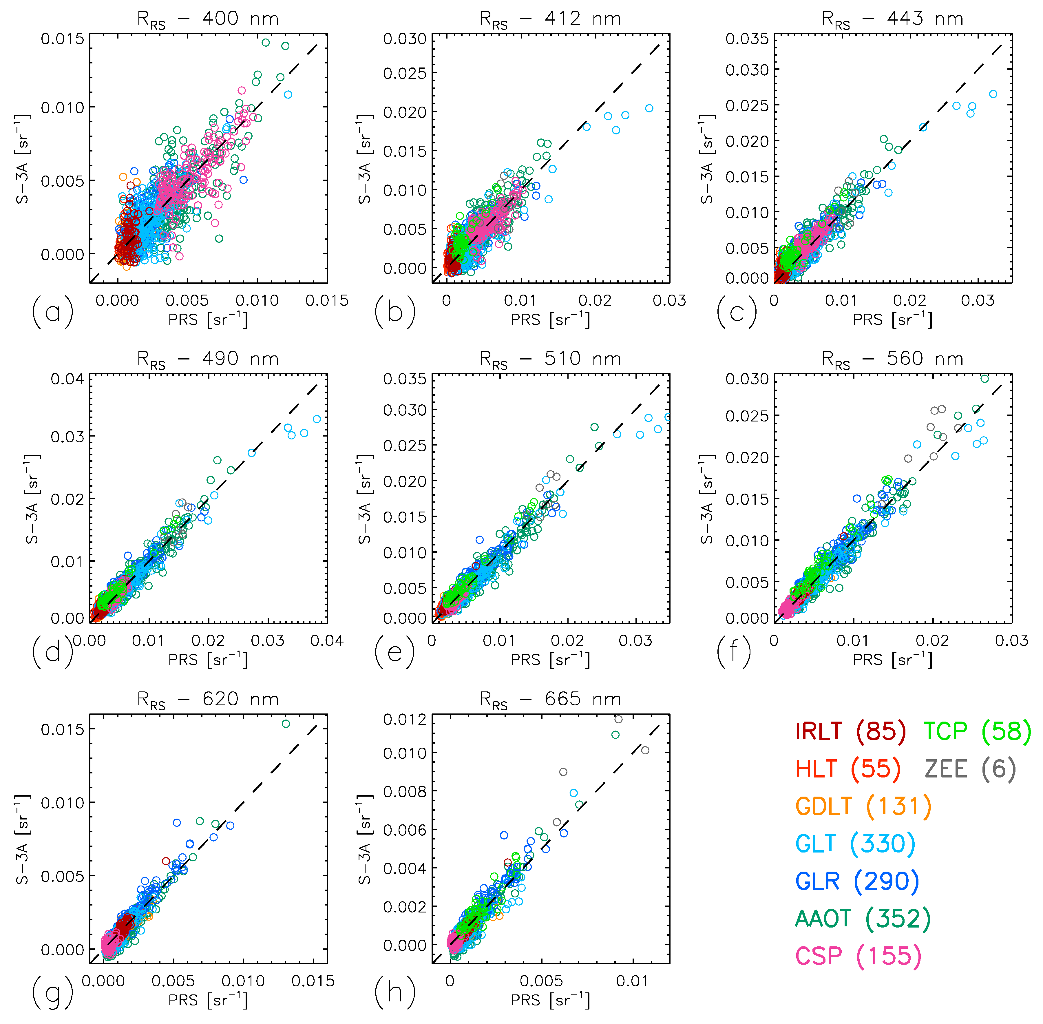
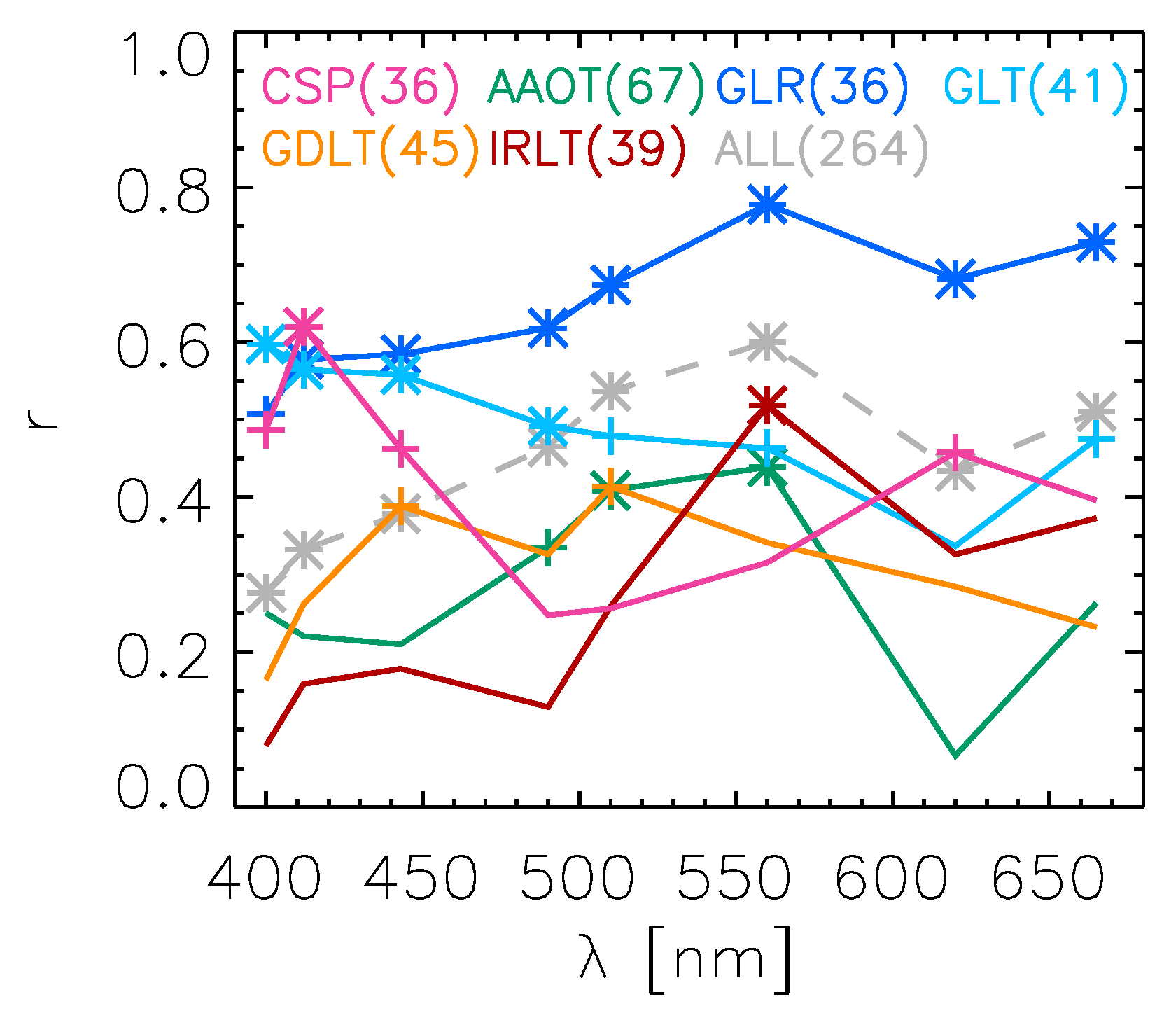
3.1. Validation Results and Uncertainty Estimates

Scatter plots comparing τ a and R R S satellite data from l 2 g e n with field measurements are shown for S-3A in Figure 1 and Figure 2, respectively. Considering that the results are comparable for S-3B, the equivalent figures are given in Supplementary Material (Figures S2 and S3). The number of matchups varies broadly by site as a function of the period of field data collection and meteorological conditions associated with the sites. For instance, AAOT has the highest number of matchups (352 and 256 for S-3A and S-3B, respectively), while CSP has 155 matchups. The number of matchups is low for the Baltic sites where PRS systems operate only in spring-summer; in the best of cases (GDLT) with data collection every year, matchups number 131 and 113 for S-3A and S-3B, respectively. Sites in the North Sea (TCP and ZEE) had an irregular time coverage with few measurements after 2019, which explains a low number of matchups.
Comparison results are very consistent with those obtained for l 2 g e n with other sensors [37,61,64,65] such as the Sea-viewing Wide Field-of-view Sensor (SeaWiFS) [66], the Medium Resolution Imaging Spectrometer (MERIS) [67], the Moderate Resolution Imaging Spectroradiometer (MODIS) [68] or the Visible Infrared Imager Radiometer Suite (VIIRS) [3,69].
As a simple measure of aerosol type [70], the Ångström exponent α a found at the various coastal sites considered here show comparable values, with averages over the matchup set around 1.5 for S-3A at AAOT, GLR, GLT, GDLT, and IRLT. Lower values are found in the North Sea (TCP, 1.24) and the western Mediterranean Sea (CSP, 1.16) more influenced by marine aerosols. Beyond these average values, α a shows a fairly large variability between 0.5 and 2 (Figure 1f) as a result of the prevalent influence of various aerosol sources. The site with the lowest average τ a at 865 nm is GDLT in the Baltic Proper (0.038 for S-3A), while it is typically 0.06 at other sites. The RMS difference Δ between PRS and satellite values for τ a is fairly homogeneous spectrally and even between sites (see Supplementary Tables S5 and S10). For instance, at AAOT, Δ decreases from 0.044 at 412 nm to 0.030 at 865 nm for S-3A (from 0.046 to 0.034 for S-3B). Values of Δ are slightly higher at GDLT (above 0.05 at all wavelengths). In relative terms, differences | ψ | m are typically found in the interval 10–18% for AAOT, GLR, or GLT, and higher for CSP (18–27%) and GDLT (26–42%). A large part of the differences is associated with systematic positive differences (biases) that tend to become more prominent with increasing wavelength (see Figure 1 and Supplementary Figure S2 for S-3A and S-3B, respectively). A much larger overestimate of τ a was noticed for the EUM products, typically in the range of 50–80% at 865 nm [36]. For α a , Δ varies from approximately 0.4 (GLT) to 0.6 (IRLT) for both S-3A and S-3B. The satellite products show a saturation of α a values above 2.2. Even though there is a large dispersion of values, they do not show the systematic underestimate of α a seen for the EUM products [36].
When looking at the reflectance spectra R R S , the various sites are associated with distinct water types [49], with R R S intervals that vary by wavelength (Figure 2 and Supplementary Figure S3 for S-3A and S-3B, respectively). At the CSP site, characterized by relatively clear waters, R R S tend to be in the upper range in the blue and switch to low values with increasing wavelengths, while the Baltic sites show low R R S in the blue. Coastal sites with moderately turbid waters (AAOT, GLR, GLT, TCP, ZEE) exhibit R R S peaking in the interval 490–560 nm. Some high values observed at GLR and GLT are associated with coccolithophore blooms in the Black Sea [51].
Validation results for l 2 g e n ’s R R S expressed as Δ , δ , | ψ | m and ψ m are listed for all sites in Supplementary Material (Tables S1–S4 and S6–S9). As demonstrated in previous studies [37,61,64,65], relative differences | ψ | m tend to be inversely related to R R S . So, for the Baltic sites, | ψ | m exceeds 50% in the blue but decreases to approximately 10% at 510–560 nm and 10–20% at 665 nm (Supplementary Tables S3 and S8). For moderately turbid sites, | ψ | m is lower in the blue with respect to Baltic waters (e.g., 21% at 412 nm at AAOT), also around 10% in the middle spectral range (from 490 to 560 nm) but usually higher in the red (e.g., 30–41% for AAOT at 665 nm). At CSP, | ψ | m is in the interval 12–17% for 400–443 nm, 8–11% for 490–560 nm and larger than 40% at 620 and 665 nm.
When considering differences expressed in RMS terms, Δ usually decreases with wavelength, from the interval 1–1.5 10−3 sr−1 at 400–412 nm to 0.1–0.4 10−3 sr−1 at 665 nm. Higher values are observed at TCP for S-3A, but the number of matchups is limited to 58. Systematic differences expressed by δ show different amplitudes, mostly in the interval ±0.5 10−3 sr−1 (Figure 3), but with a striking similarity in spectral shape (except TCP): for both S-3A and S-3B, δ increases from 400 to 443 nm, decreases from 443 to 510 nm and then stays relatively stable with a tendency to become closer to 0 in the red. Differences in the amplitude of δ between sites are not easily explained but may be associated with different water and atmospheric properties as well as broadly varying numbers of matchups. A relative peak in δ was also noticed at 443 nm in [36] for the EUM products, but it is far less evident with a larger number of matchups (Supplementary Figure S4). For the EUM products, the spectra of δ also share some spectral features between sites and for both S-3A and S-3B (like a low at 490 nm, particularly for S-3B), but it is not a general result; δ is negative (underestimate of the field data) for most bands and sites.
Knowing the uncertainties associated with the field data, validation statistics can be converted into uncertainty estimates σ S through Equation (7) [61]. Considering that uncertainties of field data are usually noticeably lower than for satellite data, σ S shows spectra comparable to Δ (Figure 4), with values decreasing from 1 to 1.5 10−3 sr−1 in the blue to less than 0.4 10−3 sr−1 in the red. Sites with moderately turbid waters (AAOT, GLR, GLT) have high values of σ S (above 1.2 10−3 sr−1 at 400–412 nm) across the spectrum relative to other sites. For CSP, σ S is also high at 400–412 nm but shows a rapid decrease with wavelength mirroring the behavior of R R S . The Baltic sites (GDLT, HLT, IRLT) are characterized by the lowest σ S across the spectrum, including in the blue where relative differences with field data are instead the largest, which is explained by R R S values close to 0 in that spectral region. Similar results are seen for the EUM products, but σ S tends to be higher than for l 2 g e n products (Supplementary Figure S5).
One important application of uncertainty values for R R S is their propagation through bio-optical algorithms in order to estimate uncertainties associated with derived products such as Chl-a or inherent optical properties (IOPs) [71], but this propagation requires the knowledge of inter-band error correlations. Assuming that the uncertainties associated with field data are significantly lower than those found for satellite data (which is supported by Figure 4, even though to a lesser extent in the red) and considering that errors in field data and satellite data are a priori not correlated, a good approximation of the inter-band error correlation r( λ l , λ m ) between bands l and m can be given by the correlation between residuals δ i ’s at these wavelengths. Please note that this assumption does not entail assuming that field values have no uncertainties.
For a given wavelength λ l , the correlation between residuals at λ l and λ m tends to decrease as the inter-band distance λ m - λ l increases (Figure 5) with values similar to those observed for other missions like MODIS or VIIRS [37]. This behavior is observed similarly for both S-3A and S-3B, for all sites, and for the EUM products too. Correlation coefficients are usually above 0.9 for adjoining wavelengths. Differences between sites are seen concerning the rate at which the correlation coefficient decreases as a function of the spectral interval. For instance, for moderately turbid water sites, the correlation coefficient stays above 0.6 for all wavelength pairs (as influenced by the scattering component of R R S ), while it decreases more sharply in clear waters (CSP) characterized by lower R R S in the green. Overall, correlations between 443 and 560 nm (blue and green bands present in many algorithm formulations) are found in the interval from 0.64 (for S-3B at CSP) to 0.87 (for S-3A at GLT); for the pair 443 and 665 nm, the interval is from 0.51 (CSP) to 0.84 (for S-3A at GLT).
Dependence of the validation results on satellite zenith angle θ v or camera number was suggested in [36] for the EUM products and is investigated here for R R S from l 2 g e n . The OLCI instrument is an imaging spectrometer with five cameras set up in a fan shape and associated with the following intervals of satellite zenith angles: −55° to −38° for the westernmost-viewing Camera 1, −38° to −22° for Camera 2, −22° to −6° for Camera 3, −6° to +9° for Camera 4 and +9° to +25° for the easternmost-viewing Camera 5 [5] (signs being negative for angles to the left, or west, from nadir, and positive to the right, or east). Orbiting with a morning local overpass, the sensor is tilted towards the west to reduce the occurrence of Sun glint conditions.
The matchup populations were split by camera number, and the average residuals were computed for each camera for sites with a sufficient number of matchups, arbitrarily fixed at 80 (Figure 6 for S-3A). The number of matchups (1343 shown for the sites AAOT, CSP, GLR, GLT, GDLT and IRLT in Figure 6) is fairly well distributed across all cameras even though it tends to decrease with camera number (27% for Camera 1 down to 13% for Camera 5) because of orbital characteristics (with a morning local overpass), viewing geometry and glint conditions still more frequent with Camera 5 (eastern part of the swath). Similar results are obtained for 920 S-3B matchups for the same sites (Supplementary Figure S6). It should be noted here that the analysis for S-3B was conducted during the post-tandem period when the satellite reached its final orbit.
Two important results emerged from this analysis. First, the relative maximum of δ observed at 443 nm with respect to lower values at 412 and 490 nm (Figure 3) is observed for all cameras in most cases (exceptions are δ slightly higher at 412 nm than at 443 nm for Camera 5 and S-3B at AAOT and GLT). The other observed feature is a lower value of δ for Camera 1 across the spectrum. This result is to be considered with caution as the standard deviations associated with δ (vertical bars in Figure 6) are often overlapping, but it is seen to a varying extent at most bands and sites. The Baltic sites (GDLT and IRLT) for S-3B are the cases where this is the least obvious (i.e., δ of Camera 1 close to the results for the other cameras). Spectra of δ are otherwise fairly close for Cameras 2 to 5 with few exceptions, like δ slightly higher for S-3A and Camera 4 at GDLT and for Camera 5 in the blue bands at IRLT or lower for S-3B and Camera 2 at GLR (in that case δ is actually close to that of Camera 1).
In the case of the EUM products, these results are noticeably different (Supplementary Figures S7 and S8): δ associated with Camera 1 are often close to δ for Cameras 2 and 3; it is actually Camera 2 that consistently shows the lowest δ regardless of the site, in some cases together with Camera 1 or 3. On the other hand, δ for Camera 5, and in some cases Camera 4, are almost always higher than for other cameras (and usually positive).
Considering the viewing angles associated with the different cameras, the results obtained for l 2 g e n can be translated in terms of relationships between δ and the satellite zenith angle θ v . Figure 7 illustrates this with the representative example of S-3A at AAOT, showing δ as a function of θ v color-coded by camera numbers. Obviously, values of δ tend to be depressed for θ v above 38° associated with Camera 1, but it can also be seen that there is a large variability around this behavior. In Figure 7, data points cover discrete angular values for θ v due to the orbital characteristics of S-3.

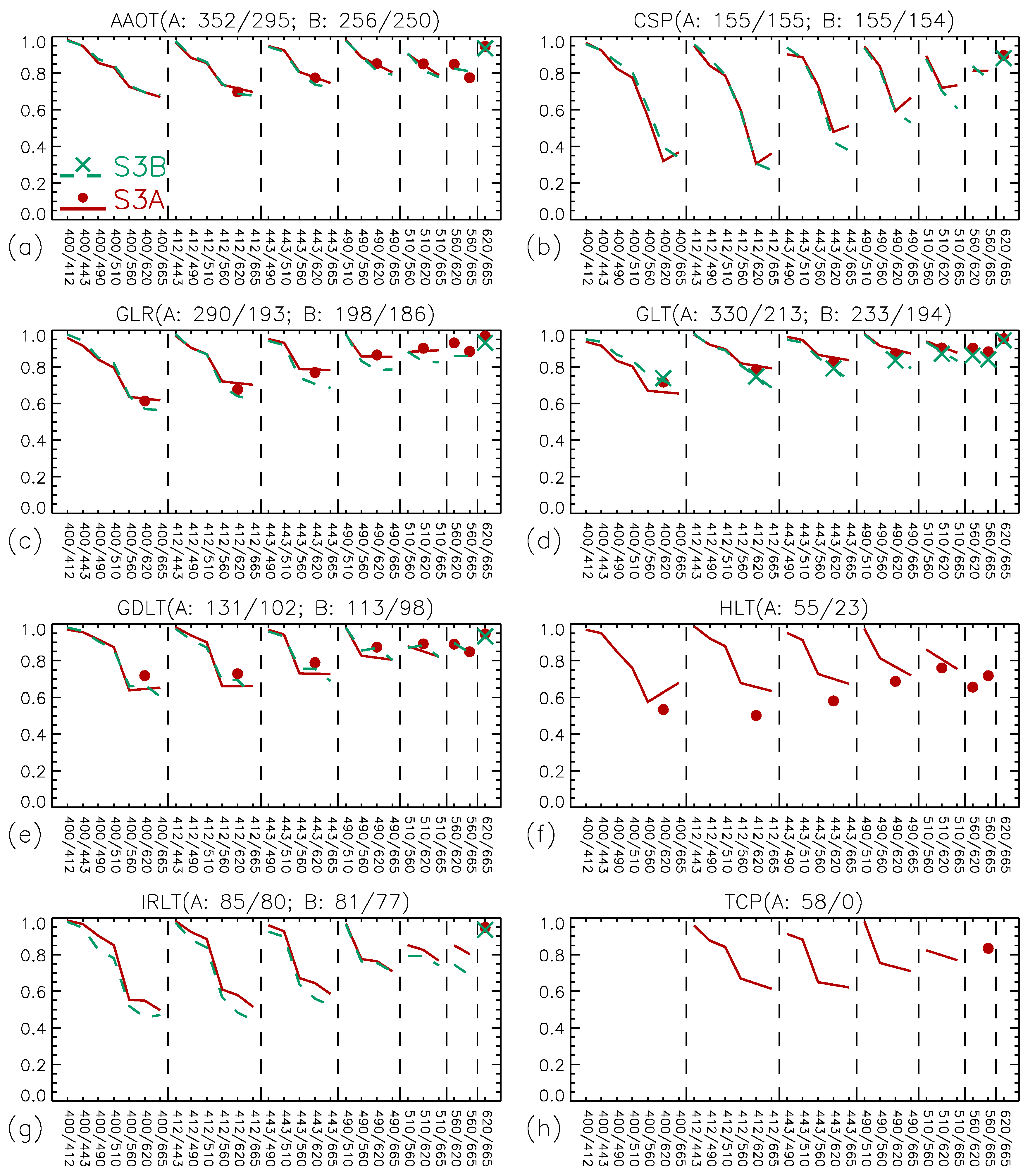
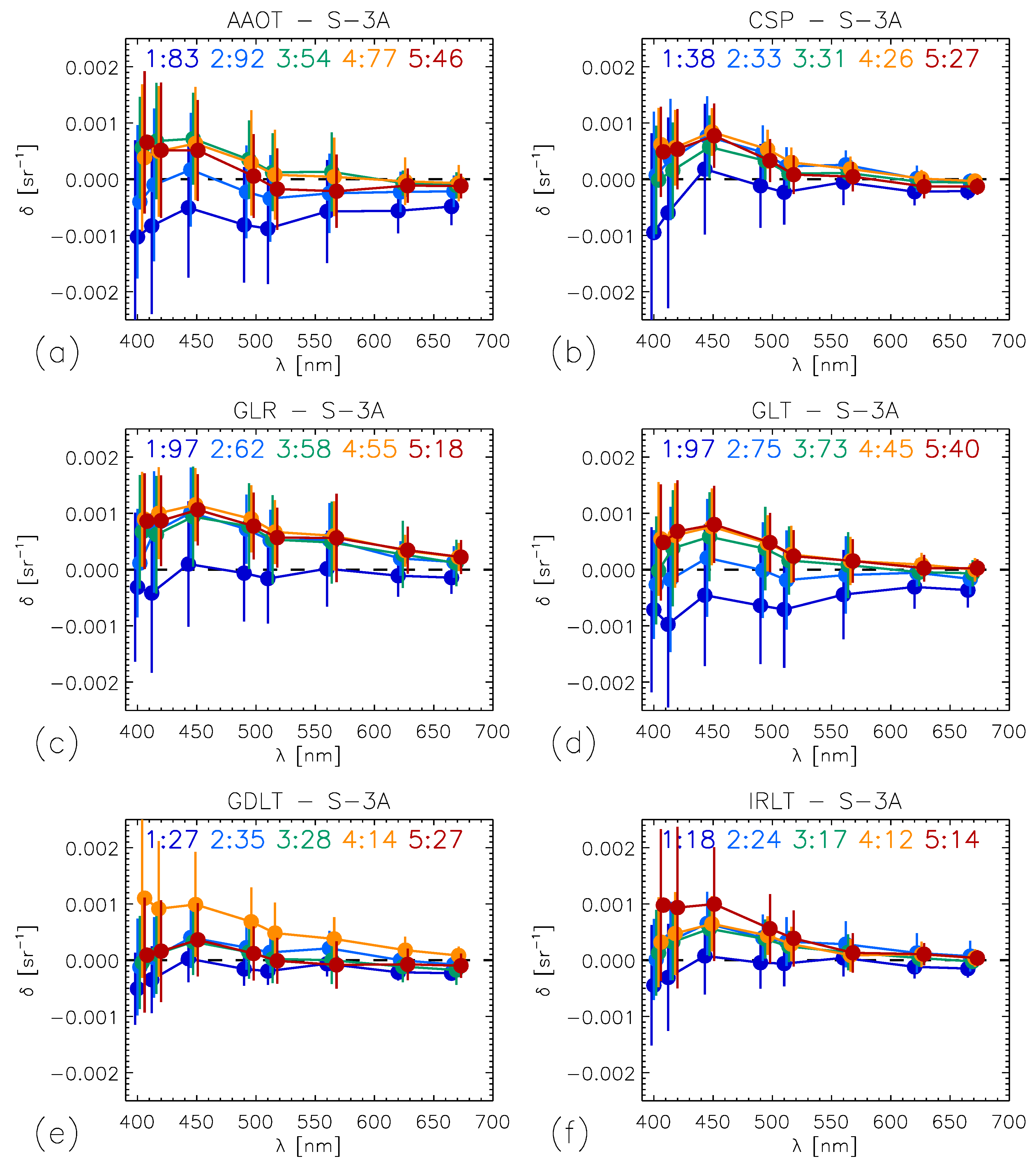
3.2. Comparison Between S-3A and S-3B R R S

The comparison between S-3A and S-3B was conducted on each site and relied on matched data selected following the same protocol as for the validation (see Section 2.1; the time difference between S-3A and S-3B matchups does not exceed 1 h). Except for ZEE (with few valid data provided by l 2 g e n ), the total number of matchups per site is between 75 and 158. Considering first a comparison for τ a (865), the agreement is remarkable for the matchups found during the tandem period but much degraded outside this period (see Supplementary Figure S9): when computing the median relative difference ψ m of S-3B values with respect to S-3A, there is only a slight underestimate (−1% to −4%) in the former case while this underestimate is much larger (i.e., ψ m lower than −20%) after the tandem phase. This underestimate is almost systematic (i.e., almost all points below the 1:1 line) for some sites (CSP, GLR, GLT), whereas cases of overestimates are also observed for the Baltic sites. For the Ångström exponent α a , differences are below 3% in tandem conditions, whereas there is a large overestimate of S-3B out of the tandem phase, from +12% at IRLT to +60% at GLR. These higher values of α a are translated for shorter wavelengths in a relative increase in S-3B τ a values with respect to S-3A. At 443 nm, the agreement during the tandem phase is excellent ( | ψ m | between 2% and 4%) while there is a larger scatter out of the tandem phase ( | ψ m | between 12% and 33%) but this dispersion is mostly centered around the 1:1 line ( ψ m from −15% at CSP to +1% at AAOT).
A similar difference between the two phases is observed for R R S at the wavelength 443 nm (Figure 8). For the tandem phase, matchup points are well located along the 1:1 line with differences ψ m between −2% and −5% (except −8% at HLT), and | ψ m | not exceeding 9%. Outside of the tandem phase, an underestimate (i.e., S-3B R R S lower) is observed, from −9% to −33%. The results described above for τ a at 443 nm suggest that this underestimate of S-3B R R S is not a compensation for differences in aerosol products. The differences outside the tandem phase tend to improve for larger wavelengths. For instance at 560 nm, ψ m is between −6% (CSP) to −1% (GDLT and GLT) during the tandem phase ( | ψ m | not exceeding 4% except at CSP), −2% (HLT) to −17% (GLT) outside (see Supplementary Figure S10).
Figure 9 shows the spectra of the mean difference δ between S-3A and S-3B l 2 g e n   R R S for their matchup sets during the tandem and the post-tandem phases. Results are difficult to interpret at 400 nm since, regardless of the phase, there is a large dispersion of data (with both over- and underestimates) for all sites (this is actually the only wavelengths for which there is no clear agreement in R R S during the tandem phase). For instance, at AAOT, | ψ m | is 45% and 50% within and out of the tandem phase, respectively. Excluding 400 nm, the spectral behavior is clearer: S-3B R R S tends to underestimate S-3A values (i.e., negative δ ) with an amplitude that decreases with wavelength. During the tandem phase, the differences are much lower for each site, as anticipated by Figure 8.
Comparable results are found for the EUM products. The agreement between S-3A and S-3B data is remarkable during the tandem phase but much degraded in the post-tandem phase with a larger scatter and average underestimate of S-3B R R S with respect to S-3A particularly in the blue part of the spectrum (Supplementary Figure S11). As for l 2 g e n products, this underestimate tends to decrease with increasing wavelength (Supplementary Figure S12). One clear difference with respect to l 2 g e n is seen at 400 nm: the EUM products show a good agreement along the 1:1 line during the tandem phase without the scatter seen for l 2 g e n (e.g., | ψ m | is 4–5% for AAOT, CSP and ZEE), and a more systematic underestimate by S-3B after the tandem phase, leading to a more continuous spectrum from 400 nm to 412 nm and longer wavelengths (compare Supplementary Figure S12 and Figure 9).

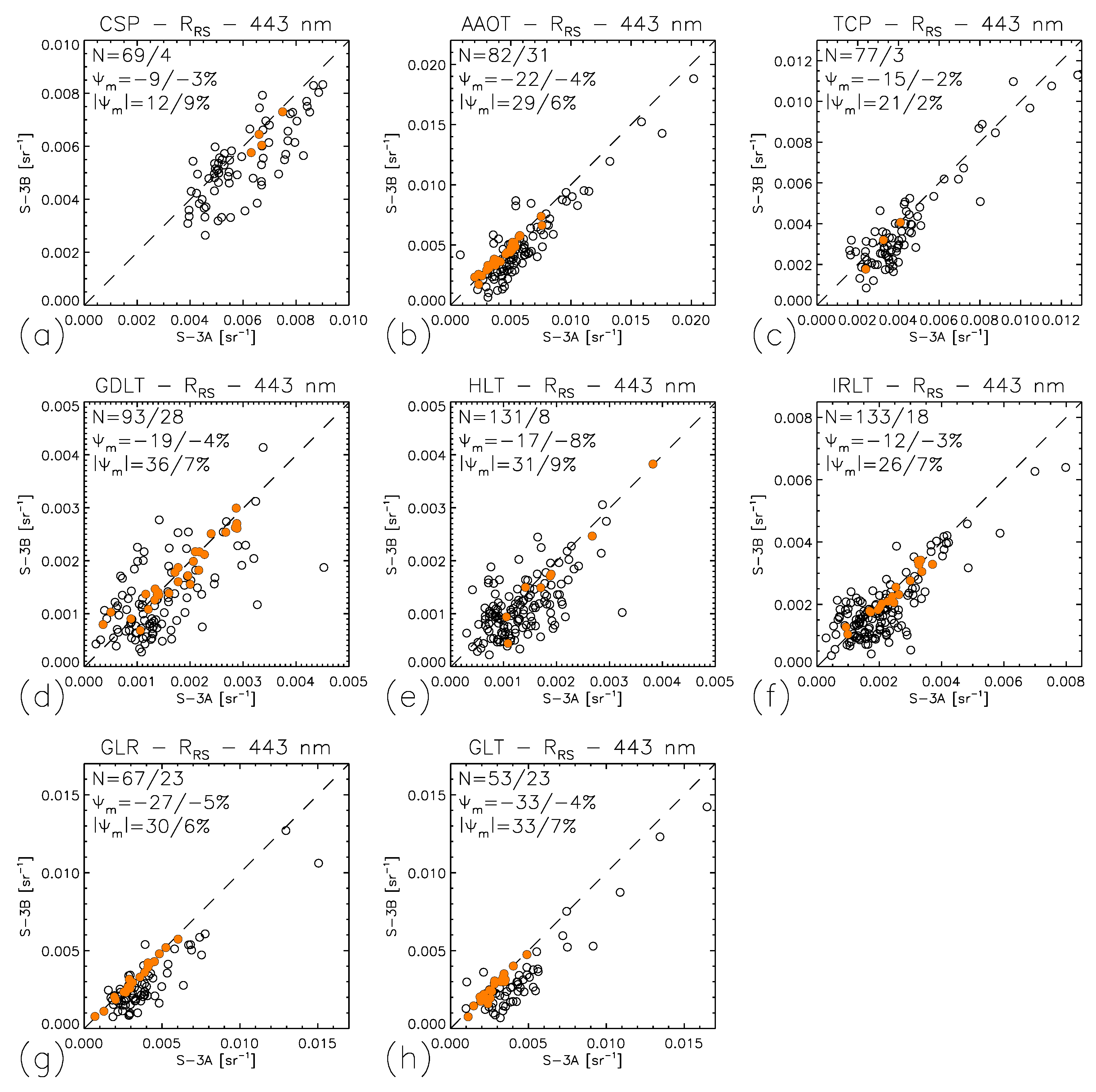
3.3. Analysis of Compatibility

As introduced in Section 2.4, an analysis of compatibility between two data sets requires an estimate of their error correlation. Following the same logic as for the inter-band correlation, the assumption was made of considering the correlation between residuals for S-3A and S-3B as a good approximation of their error correlation. This Pearson’s correlation calculation was carried out using common satellite matchups with field data (matchups selected for both S-3A and S-3B for the same day). During the tandem phase, there are only four sites with enough common matchups (arbitrarily more than 10: AAOT (N = 27), GLR (N = 23), GLT (N = 19) and GDLT (N = 13)) for a correlation analysis that shows that the correlation coefficient between S-3A and S-3B residuals is always larger than 0.89.
Considering the excellent agreement observed during the tandem phase (Section 3.2) and that it was only a preliminary phase before S-3B was placed on its nominal orbit, the correlation analysis focused on the post-tandem period. In that case, six sites show a number of common matchups larger than 25 and varying levels of correlation coefficient r between R R S residuals (Figure 10). For the CSP site, r is fairly high (0.6, level of significance p < 0.001 ) at 412 nm and decreases for longer wavelengths (following the changes in the mean R R S at that site) while losing significance. For the sites in the Black Sea, the spectra of r are regular and fairly high, mostly above 0.6 and 0.4 for GLR and GLT, respectively ( p < 0.001 or at least p < 0.01), while r tends to be smaller than 0.4 for the other sites with usually a low level of significance. Assembling matchups of all sites together, r varies from 0.28 at 400 nm, 0.33 at 412 nm to a maximum of 0.60 at 560 nm (Figure 10, p < 0.001 ). In general, the inter-mission residual correlations between S-3A and S-3B appear somewhat lower than results obtained for other pairs of missions processed with l 2 g e n (see Figure 14 in [37]). As far as τ a , the correlation between residuals at 865 nm is weak, with | r | below 0.1 for AAOT, GLR, GLT, r approximately -0.2 for GDLT and IRLT and +0.49 for CSP. At 443 nm, | r | does not exceed 0.23 except for AAOT (+0.44).
The inter-mission residual correlations between S-3A and S-3B for the EUM R R S products show r in the range 0.25–0.9, with common points as well as differences with respect to l 2 g e n (see Supplementary Figure S13). As for l 2 g e n , the level of correlation is relatively low for GDLT (less than 0.45) and high for GLR (above 0.5, p < 0.01 below 510 nm, p < 0.001 above). On the other hand, r is higher for EUM data for CSP (0.65–0.85) and AAOT (with p < 0.001 ) but lower for GLT.
Having defined the uncertainties associated with the satellite R R S (Figure 4) and having obtained an approximation for the error correlation between S-3A and S-3B R R S (Figure 10), it is possible to feed Equation (8) and assess the compatibility of the products from the two missions (again, for the post-tandem phase). Table 2 provides the fraction of cases κ for which Equation (8) is verified for coverage factors k equal to 1 and 2. In most cases for the sites CSP, AAOT, GLR, and GLT, κ is clearly below 68% for k = 1. At the Baltic sites, κ is close or above the threshold of compatibility: 65–83% at GDLT between 412 and 665 nm, 66–73% at IRLT between 400 and 665 nm (except 61% at 560 nm). For τ a at 443 nm, κ is larger than 68% (68–83%) for all sites, whereas it is somewhat smaller at 865 nm (these two bands are selected as representative wavelengths).
Taking a coverage factor k = 2, results for R R S are more favorable, i.e., κ is relatively closer to the threshold of compatibility (0.95). For instance, for AAOT between 412 and 665 nm, κ is smaller than 49% for k = 1, while it is in the interval 89-93% for k = 2 (except 81% at 510 nm). For τ a at 443 or 865 nm, κ is mostly close to 95%. The relative discrepancy observed for k = 1 or k = 2 suggests that the population of differences between S-3A and S-3B R R S departs from a normal distribution. The comparison data sets are also limited in size, usually not exceeding 100 (see Figure 8). With these points taken into account, the results of Table 2 suggest that the R R S data from S-3A and S-3B cannot be considered metrologically compatible at the considered sites, except in the Baltic Sea.
These results can be related to those observed in Figure 8 showing significant differences between S-3A and S-3B R R S during the post-tandem period, partly explained by underestimates of S-3B with respect to S-3A. Considering that the validation results vary as a function of camera number (or θ v ) (Figure 6 and Figure 7), it is logical to look at which cameras are involved in the comparison between S-3A and S-3B. The numbers of matchups per camera pair and site are reported in Table 3. For instance, for CSP, S-3A versus S-3B matchups are 11 involving Camera 3 of S-3A and Camera 1 of S-3B, 29 with Cameras 4 and 1, 21 with Cameras 5 and 1, and 8 with Cameras 5 and 2. The comparison is far from covering all possible combinations of cameras: 16 camera pairs have no matchups, while 58% of matchups (considering all sites) are associated with Camera 1 of S-3B (first row of Table 3), or 81% considering Cameras 1 and 2 of S-3B, but in both cases never including Camera 1 of S-3A and rarely Camera 2 (3 matchups). Camera 1 of S-3A is involved for only 16% of the matchups, and with Camera 4 or 5 of S-3B, combinations are associated with the western side of S-3A imagery and the eastern side of the S-3B imagery.
Validation results showed that matchups relying on Camera 1 tend to be associated with underestimates of R R S for both S-3A and S-3B with respect to other cameras (Figure 6). The fact that a large share of the S-3A versus S-3B matchups (58% combining all six sites analyzed) involve Camera 1 for S-3B, it is logical that S-3B R R S are on average biased low with respect to S-3A in a direct comparison. It can also be noted that the Baltic sites (GDLT and IRLT) have a slightly different distribution of the camera pairs, 31% of the S-3A versus S-3B matchups being associated with Camera 1 of S-3A, 30% with Camera 1 of S-3B and 39% with camera combinations not involving Camera 1. This different distribution is consistent with a higher level of compatibility found for these sites (Table 2).
Table 2 can be compared with a similar analysis conducted with the EUM R R S products (see Supplementary Table S11). For k = 1, the agreement for EUM products appears generally higher than for l 2 g e n , in some cases nearing or exceeding the level of compatibility, for instance, with κ between 400 and 620 nm in the interval 55–69% for CSP or 55–79% for GLT. An exception is the Baltic GDLT site, where κ is usually lower (except at 560 nm). For k = 2, statistics also tend to be better for the EUM products (but not at GDLT).
As for l 2 g e n products, the comparison between S-3A and S-3B for EUM data points to an underestimate by S-3B of R R S (Supplementary Figures S11 and S12). Following the same logic, the combination of cameras involved in this comparison was also compiled (Supplementary Table S12). Of course, they are very consistent with those obtained for l 2 g e n as they are heavily conditioned by orbital characteristics. Considering all sites, most S-3A versus S-3B matchups involve Camera 1 of S-3B (70%) together with Cameras 3, 4 or 5 of S-3A, or secondarily Camera 2 of S-3B (16.5%) with Cameras 4 or 5 of S-3A. Camera 1 of S-3A is involved in only 10% of the matchups (only with Cameras 4 or 5 of S-3B), largely due to GDLT.
In Section 3.2, it was noticed that satellite EUM R R S tended to be biased high with respect to field data when associated with Camera 5 and to a lower extent with Camera 4 (this is particularly the case for S-3A), while δ was much closer to 0 for Cameras 1 to 3. Considering that 35% of the S-3A versus S-3B matchups are associated with Camera 5 for S-3A (and Cameras 1–3 for S-3B) and an additional 36% with Camera 4 of S-3A (and Cameras 1–2 for S-3B), this is consistent with the underestimate of R R S by S-3B with respect to S-3A, in turn leading to rather low statistics of compatibility.

4. Discussion and Conclusions

An analysis of compatibility between two data sets requires an estimate of the related uncertainties as well as of their error correlations (according to Equation (8)). This explains why the current work focused on specific sites where enough field data were available to derive uncertainty estimates for OLCI’s R R S and an approximation of the error correlations. At the level of European waters, this geographic limitation is only relative since the water types encountered at these sites are representative of a large part of the natural variability found in European seas [49]. A more stringent limitation is associated with the number of matchups supporting the analysis. Ideally, an analysis of compatibility would require concurrent S-3A and S-3B data together with field data, conditions that are not often met, even for AERONET-OC sites where measurements are continuous (at maximum, N = 67 at AAOT for l 2 g e n in the post-tandem period). An alternative would be to combine all data, but this has the drawback of ignoring the specific characteristics of the various sites, whether they are due to atmospheric or water properties, or latitude.
When processed with the l 2 g e n atmospheric correction, the validation results obtained for R R S are very close for S-3A and S-3B and are consistent with those found for other missions such as MODIS or VIIRS processed with the same algorithm [37]. This applies to τ a and R R S . In the case of the average differences with respect to field data, δ , the statistics for R R S are slightly lower for S-3B (i.e., towards more negative values, Figure 3) but the spectral shapes are really similar for both missions, with relatively high δ at 443 nm and low δ at 510 nm, which could suggest issues with the calibration and/or the algorithms. The similarity between S-3A and S-3B and with other missions is also seen in the uncertainty estimates σ S (Figure 4). In line with R R S amplitudes, coastal sites with moderately turbid waters such AAOT, GLT, GLR, or TCP show the highest σ S across the spectrum, while absorbing Baltic waters show the lowest. The CSP site associated with clearer waters has relatively high σ S in the blue and low σ S in the green and red parts of the spectrum. If the spectral (i.e., inter-band) error correlation can be approximated by the correlation of residuals, it is usually greater than 0.5 (except at CSP, Figure 5) depending on the inter-band distance.
For l 2 g e n   R R S from both S-3A and S-3B, and all sites to a varying extent, δ is lower (i.e., towards more negative values) for matchups with field data associated with Camera 1. This camera is the only one with satellite zenith angles θ v above 38° and the relative effects of camera number or θ v in the atmospheric correction are not easily distinguished. Results obtained for other missions (MODIS, VIIRS) processed with l 2 g e n showed some slight dependence on θ v (with decreasing residuals) for some sites (AAOT, GLT, GLR), which would rather suggest an effect of the algorithm (even though this is not observed at all sites, like GDLT or CSP).
In the EUM case, a positive bias is observed for Camera 5 and for Camera 4 in some cases, which could point to issues related to the cameras, but the eastern side of the swath is also the part most influenced by glint conditions. In [36], a distinction was made between EUM matchups obtained with θ v below or above 30°, with a largely negative bias ψ m in the latter case for the sites AAOT, GLR and GLT, suggesting an impact of Camera 1 or an influence of θ v . In reality, this was a simplified interpretation: often, matchups associated with Camera 2 (associated with θ v between 22° and 38°) show a comparable or more negative bias than those of Camera 1. For instance, at AAOT, ψ m for S-3A in the interval 412–560 nm varies from −14% to −9% for Camera 1, and from −22% to −11% for Camera 2, while ψ m for S-3B varies from −19% to −13% for Camera 1, and from −23% to −13% for Camera 2. Therefore, on average matchups associated with Camera 1 and Camera 2 with θ v > 30° are characterized by a significant negative bias, while the matchups of Camera 2 with θ v < 30° (still with a negative bias) are compensated for by the matchups associated with Cameras 4 and 5 with θ v always <30° (with a positive bias). The distinct behaviors between the EUM and l 2 g e n   R R S products may be attributed to differences in calibration, which could introduce systematic effects, as well as differences in the underlying algorithms, even though they share some common elements. For instance, the Bright-Pixel Correction module active in the EUM atmospheric correction [35,72] relies on channels above 700 nm (up to 1020 nm in turbid waters) not used in the standard l 2 g e n configuration; cross-camera differences affecting these bands would propagate to the rest of the spectrum differently with respect to l 2 g e n .
Regardless of algorithm precise behaviors, both products tend to show relatively higher residuals for Cameras 4 and 5 and lower residuals for Cameras 1 or 2 (Figure 6 and Figures S6–S8, with similar consequences on the direct comparison between S-3A and S-3B data (S-3B R R S usually lower than S-3A R R S ); in addition, residual differences between products observed by adjacent cameras (or even by different detectors within a camera) are readily observed as artefactual gradients in OLCI imagery [41,73,74]. This currently makes any conclusion on the relative influence of camera or viewing geometry (and their consequence through the atmospheric correction algorithms) rather speculative. Certainly, the intertwined effects of geometry and cameras cannot be excluded.
These behaviors have clear implications in the S-3A versus S-3B comparison and the analysis of compatibility of l 2 g e n -derived or EUM R R S products. While matching data appear very close during the tandem phase, in the post-tandem phase, a large part of the matchups rely on Camera 1 for S-3B and Cameras 4 and 5 for S-3A (Table 3, Supplementary Table S12), so that S-3B R R S tend to be lower on average than matching S-3A values (Figure 8 and Figure 9, Supplementary Figures S11 and S12). This degrades the level of compatibility between S-3A and S-3B R R S , and metrological compatibility cannot be demonstrated for level-2 daily data. The analysis of compatibility relied on estimates of the error correlation between S-3A and S-3B. These estimates are to be taken with caution as they are based on a limited number of points, which might have an impact on the level of significance of the correlation (Figure 10). To test the importance of that term that decreases the right-hand side of Equation (8) and, therefore, the percentage of compatibility, the same calculations were repeated assuming no error correlation between S-3A and S-3B (Table 4). For a coverage factor k = 1, κ is close to 68% for CSP and GLR, above 68% for GDLT and IRLT, but still below 68% for AAOT and GLT. For k = 2, κ is close to or greater than 95% in most cases. This analysis underlines the importance of obtaining robust estimates of cross-mission error correlations to assess compatibility, besides their necessity for uncertainty propagation in multi-mission merging schemes.
These conclusions, suggesting insufficient compatibility, certainly have an impact on derived products such as Chl-a as errors are propagated through bio-optical algorithms [60,71]. Uncertainties expressed in relative terms generally tend to increase for derived products, but without dedicated studies, it is challenging to conclude their inter-mission compatibility based on the results obtained with R R S as the propagation of errors depends on the functional form of the associated algorithm. For instance, band-ratio and band-difference algorithms used for Chl-a behave differently when handling errors in R R S [75]. Besides implications on pixel-based uncertainties, the potential cross-camera issues discussed in this work would also have a bearing on spatial analyses using ocean-color data, such as front detection [76], by introducing spurious artifacts in the imagery.
These results deserve additional comments related to the Sentinel-3 missions. Strictly speaking, this analysis does not evaluate the two systems, S-3A and S-3B, as a whole but only a restricted set of camera pairs, which can be a limitation for an exercise conducted with level-2 data. A way to circumvent this limitation would be to evaluate the compatibility of temporally averaged data, for instance, taking one (27 days) or multiple full orbital cycles, so that each location would be observed with all possible geometries and cameras of observation. But this approach is facing other issues [60]. First, it is not guaranteed that each time-averaged product (S-3A and S-3B) will be based on the same sampling (i.e., days), which may introduce an unknown uncertainty term associated with representativeness. Then, determining the uncertainties of temporal composites requires knowledge of the error correlation associated with daily data to propagate their uncertainties, a step currently poorly characterized. Therefore, even though assessing the compatibility of S-3A and S-3B products with time composite data would make sense, robust uncertainty estimates for these data are missing.
This study leads to two complementary recommendations. The first, directly related to the present results, calls for investigations aiming at ensuring a better consistency of OLCI results across-track (i.e., across cameras). Besides the issue of compatibility, this would improve the validation results of the OLCI ocean-color products and the overall quality of the OLCI imagery (by lessening across-track artifacts). Then, additional work is needed to fully characterize the uncertainties affecting R R S and allow a complete uncertainty propagation to temporal (and spatial) composites that are the data records usually employed for climate analysis. Achieving this step is required to test the metrological compatibility of data records from different satellite missions.

Supplementary Materials

The following are available online at https://www.mdpi.com/article/10.3390/rs17071132/s1, Figure S1: Maps of the AERONET-OC sites used in the study; Figure S2: Scatter-plots of matching PRS and S-3B l 2 g e n   τ a values at selected wavelengths equivalent for α a ; Figure S3: Scatter-plots of matching PRS and S-3B l 2 g e n   R R S values; Figure S4: Spectra at the OLCI bands of the mean difference δ between satellite EUM and field data of R R S for S-3A and S-3B; Figure S5: Spectra at the OLCI bands of the uncertainty estimate σ S for EUM satellite R R S for S-3A and S-3B; Figure S6: Spectra of the mean difference δ between satellite EUM and field data of R R S for S-3A; Figure S7: Spectra of the mean difference δ between satellite EUM and field data of R R S for S-3A; Figure S8: Spectra of the mean difference δ between satellite EUM and field data of R R S for S-3B; Figure S9: Scatter-plots of matching S-3A and S-3B l 2 g e n   τ a values at 865 nm; Figure S10: Scatter-plots of matching S-3A and S-3B l 2 g e n   R R S values at 560 nm; Figure S11: Scatter-plots of matching S-3A and S-3B EUM R R S values at 443 nm; Figure S12: Spectra of the mean difference δ between S-3B and S-3A EUM R R S values; Figure S13: Spectra of the Pearson’s correlation coefficient between residuals of S-3A and S-3B EUM R R S products; Table S1: Validation statistics Δ (root-mean-square difference between satellite and field data) per site for R R S S-3A data obtained from l 2 g e n ; Table S2: Validation statistics δ (mean difference between satellite and field data) per site for S-3A R R S data obtained from l 2 g e n ; Table S3: Validation statistics | ψ | m (median absolute relative difference between satellite and field data) per site for S-3A R R S data obtained from l 2 g e n ; Table S4: Validation statistics ψ m (median relative difference between satellite and field data) per site for S-3A R R S data obtained from l 2 g e n ; Table S5: Validation statistics Δ (root-mean-square difference between satellite and field data) per site for τ a S-3A data obtained from l 2 g e n ; Table S6: Validation statistics Δ (root-mean-square difference between satellite and field data) per site for R R S S-3B data obtained from l 2 g e n ; Table S7: Validation statistics δ (mean difference between satellite and field data) per site for R R S S-3A data obtained from l 2 g e n ; Table S8: Validation statistics | ψ | m (median absolute relative difference between satellite and field data) per site for S-3A R R S data obtained from l 2 g e n ; Table S9: Validation statistics ψ m (median relative difference between satellite and field data) per site for S-3B R R S data obtained from l 2 g e n ; Table S10: Validation statistics Δ (root-mean-square difference between satellite and field data) per site for τ a S-3B data obtained from l 2 g e n ; Table S11: Percentage of compatibility for EUM products computed according to Equation 8 for the various sites; Table S12: Numbers of EUM match-ups S-3A and S-3B as a function of camera pairs for the various sites.

Author Contributions

Conceptualization, F.M. and I.C.; methodology, F.M. and I.C.; formal analysis, F.M. and I.C.; data curation, F.M., I.C. and P.S.; writing—original draft preparation, F.M.; writing—review and editing, F.M., I.C. and P.S.; visualization, F.M.; funding acquisition, F.M. All authors have read and agreed to the published version of the manuscript.

Funding

The support provided by DG DEFIS, i.e., the European Commission Directorate-General for Defense Industry and Space, and the Copernicus Program is gratefully acknowledged.

Data Availability Statement

Data used in this work are from publicly available datasets. These datasets are available at https://aeronet.gsfc.nasa.gov/new_web/ocean_color.html (accessed on 17 March 2025), https://data.eumetsat.int/data/map/EO:EUM:DAT:0408 (accessed on 17 March 2025), and https://oceancolor.gsfc.nasa.gov/ (accessed on 17 March 2025).

Acknowledgments

EUMETSAT and NASA (Ocean Biology—Distributed Active Archive Center, OB.DAAC) are thanked for the availability of data and processing software. The support provided by DG DEFIS, i.e., the European Commission Directorate-General for Defense Industry and Space, and the Copernicus Program is also gratefully acknowledged. The contribution of M. Talone (principal investigator of the Casablanca Platform AERONET-OC site) and D. Van der Zande (principal investigator of the Thornton_C-Power and Zeebrugge-MOW1 sites) is really appreciated. G. Zibordi and B. Bulgarelli are thanked for their contribution to AERONET-OC.

Conflicts of Interest

The authors declare no conflicts of interest. The funders had no role in the design of the study, in the collection, analyses, or interpretation of data, in the writing of the manuscript, or in the decision to publish the results.

References

  1. Le Traon, P.Y. Satellites and operational oceanography. In New Frontiers in Operational Oceanography; Chassignet, E., Pascual, A., Tintoré, J., Verron, J., Eds.; GODAE Ocean View; Florida State University: Tallahassee, FL, USA, 2018; Chapter 7; pp. 161–189. [Google Scholar]
  2. Casey, K.; Brandon, T.; Cornillon, P.; Evans, R. The past, present and future of the AVHRR Pathfinder SST program. In Oceanography from Space: Revisited; V. Barale, J.G., Alberotanza, L., Eds.; Springer: Heidelberg, Germany, 2010; Chapter 16; pp. 273–287. [Google Scholar]
  3. Goldberg, M.D.; Kilcoyne, H.; Cikanek, H.; Mehta, A. Joint Polar Satellite System: The United States next generation civilian polar-orbiting environmental satellite system. J. Geophys. Res. 2013, 118, 13463–13475. [Google Scholar] [CrossRef]
  4. EU. Regulation(EU) No 377/2014 of the European Parliament and of the Council of 3 April 2014 Establishing the Copernicus Programme; Official Journal of the European Union: Luxembourg, 2014; 23p. [Google Scholar]
  5. Donlon, C.; Berruti, B.; Buongiorno, A.; Ferreira, M.H.; Féménias, P.; Frerick, J.; Goryl, P.; Klein, U.; Laur, H.; Mavrocordatos, C.; et al. The Global Monitoring for Environment and Security (GMES) Sentinel-3 mission. Remote Sens. Environ. 2012, 120, 37–57. [Google Scholar] [CrossRef]
  6. Bojinski, S.; Verstraete, M.; Peterson, T.; Richter, C.; Simmons, A.; Zemp, M. The concept of Essential Climate Variables in support of climate research, applications, and policy. Bull. Am. Meterol. Soc. 2014, 95, 1431–1443. [Google Scholar]
  7. GCOS. Systematic Observation Requirements for Satellite-Based Products for Climate; GCOS-154, Supplemental Details to the Satellite-Based Component of the “Implementation Plan for the Global Observing System for Climate in Support of the UNFCC”; World Meteorological Organization: Geneva, Switzerland, 2011; 138p. [Google Scholar]
  8. Morel, A.; Antoine, D.; Gentili, B. Bidirectional reflectance of oceanic waters: Accounting for Raman emission and varying particle scattering phase function. Appl. Opt. 2002, 41, 6289–6306. [Google Scholar] [CrossRef]
  9. Gordon, H. Atmospheric correction of ocean color imagery in the Earth Observing System era. J. Geophys. Res. 1997, 102, 17081–17106. [Google Scholar]
  10. IOCCG. Why Ocean Colour? The Societal Benefits of Ocean-Colour Technology, Reports of the International Ocean Colour Coordinating Group; Platt, T., Hoepffner, N., Stuart, V., Brown, C., Eds.; No. 7; IOCCG: Dartmouth, NS, Canada, 2008. [Google Scholar]
  11. McClain, C.; Feldman, G.; Hooker, S. An overview of the SeaWiFS project and strategies for producing a climate research quality global ocean bio-optical time series. Deep Sea Res. 2004, 51, 5–42. [Google Scholar]
  12. Brewin, R.; Sathyendranath, S.; Kulk, G.; Rio, M.H.; Concha, J.; Bell, T.; Bracher, A.; Fichot, C.; Frölicher, T.; Galí, M.; et al. Ocean carbon from space: Current status and priorities for the next decade. Earth-Sci. Rev. 2023, 240, 104386. [Google Scholar] [CrossRef]
  13. Henson, S.; Sarmiento, J.; Dunne, J.; Bopp, L.; Lima, I.; Doney, S.; John, J.; Beaulieu, C. Detection of anthropogenic climate change in satellite records of ocean chlorophyll and productivity. Biogeosciences 2010, 7, 621–640. [Google Scholar]
  14. Yoder, J.; Kennelly, M.; Doney, S.; Lima, I. Are trends in SeaWiFS chlorophyll time-series unusual relative to historic variability? Acta Oceanol. Sin. 2010, 29, 1–4. [Google Scholar]
  15. Cael, B.; Bisson, K.; Boss, E.; Dutkiewicz, S.; Henson, S. Global climate-change trends detected in indicators of ocean ecology. Nature 2023, 619, 551–554. [Google Scholar] [CrossRef]
  16. Zhang, C.; Hu, C.; Shang, S.; Muller-Karger, F.; Li, Y.; Dai, M.; Huang, S.; Ning, X.; Hong, H. Bridging between SeaWiFS and MODIS for continuity of chlorophyll-a concentration assessments off Southeastern China. Remote Sens. Environ. 2006, 102, 250–263. [Google Scholar] [CrossRef]
  17. Djavidnia, S.; Mélin, F.; Hoepffner, N. Comparison of global ocean colour data records. Ocean Sci. 2010, 6, 61–76. [Google Scholar] [CrossRef]
  18. Mélin, F.; Zibordi, G.; Djavidnia, D. Merged series of normalized water leaving radiances obtained from multiple satellite missions for the Mediterranean Sea. Adv. Space Res. 2009, 43, 423–437. [Google Scholar] [CrossRef]
  19. Mélin, F. Global distribution of the random uncertainty associated with satellite derived Chla. IEEE Geosci. Remote Sens. Lett. 2010, 7, 220–224. [Google Scholar] [CrossRef]
  20. Barnes, B.; Hu, C. Cross-sensor continuity of satellite-derived water clarity in the Gulf of Mexico: Insights into temporal aliasing and implications for long-term water clarity assessment. IEEE Trans. Geosci. Remote Sens. 2015, 53, 1761–1772. [Google Scholar] [CrossRef]
  21. Mélin, F. Impact of inter-mission differences and drifts on chlorophyll-a trend estimates. Int. J. Remote Sens. 2016, 37, 2061–2079. [Google Scholar] [CrossRef]
  22. Mélin, F.; Vantrepotte, V.; Chuprin, A.; Grant, M.; Jackson, T.; Sathyendranath, S. Assessing the fitness-for-purpose of satellite multi-mission ocean color climate data records: A protocol applied to OC-CCI chlorophyll-a data. Remote Sens. Environ. 2017, 203, 139–151. [Google Scholar] [CrossRef]
  23. VIM. International Vocabulary of Metrology—Basic and General Concepts and Associated Terms; JCGM 200; Joint Committee for Guides in Metrology, Bureau International des Poids et Mesures: Sévres, France, 2012; 108p. [Google Scholar]
  24. Kyryliuk, D.; Kratzer, S. Evaluation of Sentinel-3A OLCI products derived using the Case-2 Regional CoastColour processor over the Baltic Sea. Sensors 2019, 19, 3609. [Google Scholar] [CrossRef]
  25. Mograne, M.; Jamet, C.; Loisel, H.; Vantrepotte, V.; Mériaux, X.; Cauvin, A. Evaluation of five atmospheric correction algorithms over French optically-complex waters for the Sentinel-3A OLCI ocean color sensor. Remote Sens. 2019, 11, 668. [Google Scholar] [CrossRef]
  26. Li, J.; Jamet, C.; Zhu, J.; Han, B.; Li, T.; Yang, A.; Guo, K.; Jia, D. Error budget in the validation of radiometric products derived from OLCI around the China Sea from open ocean to coastal waters compared with MODIS and VIIRS. Remote Sens. 2019, 11, 2400. [Google Scholar] [CrossRef]
  27. Giannini, F.; Hunt, B.; Jacoby, D.; Costa, M. Performance of OLCI Sentinel-3A satellite in the Northeast Pacific coastal waters. Remote Sens. Environ. 2021, 256, 112317. [Google Scholar] [CrossRef]
  28. Liu, H.; He, X.; Li, Q.; Hu, X.; Ishizaka, J.; Kratzer, S.; Yang, C.; Shi, T.; Hu, S.; Zhou, Q.; et al. Evaluation of ocean color atmospheric correction methods for Sentinel-3 OLCI using global automatic in situ observations. IEEE Trans. Geosci. Remote Sens. 2022, 60, 4206319. [Google Scholar] [CrossRef]
  29. Arena, M.; Pratolongo, P.; Loisel, H.; Tran, M.; Schaffer Ferreira Jorge, D.; Delgado, A. Optical water characterization and atmospheric correction assessment of estuarine and coastal waters around the AERONET-OC Bahia Blanca. Front. Remote Sens. 2024, 5, 1305787. [Google Scholar] [CrossRef]
  30. González Vilas, L.; Brando, V.; Di Cicco, A.; Colella, S.; D’Alimonte, D.; Kajiyama, T.; Attila, J.; Schroeder, T. Assessment of ocean color atmospheric correction methods and development of a regional ocean color operational dataset for the Baltic Sea based on Sentinel-3 OLCI. Front. Mar. Sci. 2024, 10, 1256990. [Google Scholar] [CrossRef]
  31. Gordon, H.; Wang, M. Retrieval of water-leaving radiance and aerosol optical thickness over the oceans with SeaWiFS: A preliminary algorithm. Appl. Opt. 1994, 33, 443–452. [Google Scholar]
  32. Franz, B.; Bailey, S.; Werdell, P.; McClain, C. Sensor-independent approach to the vicarious calibration of satellite ocean color radiometry. Appl. Opt. 2007, 46, 5068–5082. [Google Scholar]
  33. Ahmad, Z.; Franz, B.; McClain, C.; Kwiatkowska, E.; Werdell, P.; Shettle, E.; Holben, B. New aerosol models for the retrieval of aerosol optical thickness and normalized water-leaving radiances from the SeaWiFS and MODIS sensors over coastal regions and open oceans. Appl. Opt. 2010, 49, 5545–5560. [Google Scholar] [CrossRef]
  34. EUMETSAT. Sentinel-3 Product Notice—OLCI Level-2 Ocean Colour. In S3.PN-OLCI-L2M.003.00; 2021; 10p. Available online: https://user.eumetsat.int/s3/eup-strapi-media/S3_PN_OLCI_L2_M_003_00_Sentinel_3_Product_Notice_OLCI_Level_2_Ocean_Colour_be36d5b00c.pdf (accessed on 17 March 2025).
  35. EUMETSAT. Ocean Colour Standard Atmospheric Correction, Algorithm Theoretical Basis, v4.2. EUM/21/SAC/ATBD. 2022. 114p. Available online: https://www-cdn.eumetsat.int/files/2022-11/EUMETSAT_OC-SAC_ATBD_v4.2_web.pdf (accessed on 17 March 2025).
  36. Zibordi, G.; Kwiatkowska, E.; Mélin, F.; Talone, M.; Cazzaniga, I. Assessment of OLCI-A and OLCI-B radiometric data products across European seas. Remote Sens. Environ. 2022, 272, 112911. [Google Scholar]
  37. Mélin, F. Validation of ocean color remote sensing reflectance data: Analysis of results at European coastal sites. Remote Sens. Environ. 2022, 280, 113153. [Google Scholar] [CrossRef]
  38. EUMETSAT. Recommendations for Sentinel-3 OLCI ocean colour product validations in comparison with in situ measurements—Match-up protocols. In UM/SEN3/DOC/19/1092968; EUMETSAT: Darmstadt, Germany, 2019; 12p, Available online: https://user.eumetsat.int/s3/eup-strapi-media/Recommendations_for_Sentinel_3_OLCI_Ocean_Colour_product_validations_in_comparison_with_in_situ_measurements_Matchup_Protocols_V8_B_e6c62ce677.pdf (accessed on 17 March 2025).
  39. Barnes, B.; Cannizzaro, J.; English, D.; Hu, C. Validation of VIIRS and MODIS reflectance data in coastal and oceanic waters: An assessment of methods. Remote Sens. Environ. 2019, 220, 110–123. [Google Scholar]
  40. Clerc, S.; Donlon, C.; Borde, F.; Lamquin, N.; Hunt, S.; Smith, D.; McMillan, M.; Mittaz, J.; Woolliams, E.; Hammond, M.; et al. Benefits and lessons learnt from the Sentinel-3 tandem phase. Remote Sens. 2020, 12, 2668. [Google Scholar] [CrossRef]
  41. Lamquin, N.; Clerc, S.; Donlon, C. OLCI A/B tandem phase analysis, Part 1: Level-1 homogenisation and harmonisation. Remote Sens. 2020, 12, 1804. [Google Scholar] [CrossRef]
  42. Holben, B.; Eck, T.; Slutker, I.; Tanré, D.; Buis, J.; Setzer, A.; Vermote, E.; Reagan, J.; Kaufman, Y.; Nakajima, T.; et al. AERONET: A federated instrument network and data archive for aerosol characterization. Remote Sens. Environ. 1998, 66, 1–16. [Google Scholar] [CrossRef]
  43. Zibordi, G.; Holben, B.; Talone, M.; D’Alimonte, D.; Slutsker, I.; Giles, D.; Sorokin, M. Advances in the Ocean Color component of the Aerosol Robotic Network (AERONET-OC). J. Atmos. Ocean. Technol. 2021, 38, 725–746. [Google Scholar] [CrossRef]
  44. Zibordi, G.; Hooker, S.; Berthon, J.F.; D’Alimonte, D. Autonomous above-water radiance measurements from an offshore platform: A field assessment experiment. J. Atmos. Ocean. Technol. 2002, 19, 808–819. [Google Scholar] [CrossRef]
  45. Zibordi, G.; Strömbeck, N.; Mélin, F.; Berthon, J.F. Tower-based radiometric observations at a coastal site in the Baltic Proper. Estuarine Coast. Shelf Sci. 2006, 69, 649–654. [Google Scholar] [CrossRef]
  46. Zibordi, G.; Berthon, J.F.; Mélin, F.; D’Alimonte, D.; Kaitala, S. Validation of satellite ocean color primary products at optically complex coastal sites: Northern Adriatic Sea, northern Baltic Proper, Gulf of Finland. Remote Sens. Environ. 2009, 113, 2574–2591. [Google Scholar] [CrossRef]
  47. Zibordi, G.; Holben, B.; Slutsker, I.; Giles, D.; D’Alimonte, D.; Mélin, F.; Berthon, J.F.; Vandemark, D.; Feng, H.; Schuster, G.; et al. AERONET-OC: A network for the validation of ocean color primary products. J. Atmos. Ocean. Technol. 2009, 26, 1634–1651. [Google Scholar] [CrossRef]
  48. Zibordi, G.; Mélin, F.; Berthon, J.F.; Talone, M. In situ autonomous optical raiometry measurements for satellite ocean color validation in the Western Black Sea. Ocean Sci. 2015, 11, 275–286. [Google Scholar] [CrossRef]
  49. Cazzaniga, I.; Mélin, F. How representative are AERONET-OC sites of European marine waters? Remote Sens. 2024, 16, 1793. [Google Scholar] [CrossRef]
  50. Cazzaniga, I.; Zibordi, G.; Mélin, F. Spectral features of ocean colour radiometric products in the presence of cyanobacteria blooms in the Baltic Sea. Remote Sens. Environ. 2023, 287, 113464. [Google Scholar]
  51. Cazzaniga, I.; Zibordi, G.; Mélin, F. Spectral variations of the remote sensing reflectance during coccolithophore blooms in the Western Black Sea. Remote Sens. Environ. 2021, 264, 112607. [Google Scholar]
  52. Thuillier, G.; Hersé, M.; Labs, D.; Foujols, T.; Peetermans, W.; Gillotay, D.; Simon, P.; Mandel, H. The solar spectral irradiance from 200 to 2400 nm as measured by the SOLSPEC spectrometer from the ATLAS and EURECA missions. Sol. Phys. 2003, 214, 1–22. [Google Scholar] [CrossRef]
  53. Zibordi, G.; D’Alimonte, D.; Kajiyama, T. Automated quality control of AERONET-OC LWN data. J. Atmos. Ocean. Technol. 2022, 39, 1961–1972. [Google Scholar] [CrossRef]
  54. Cazzaniga, I.; Zibordi, G. AERONET-OC LWN uncertainties: Revisited. J. Atmos. Ocean. Technol. 2023, 40, 411–425. [Google Scholar] [CrossRef]
  55. Smirnov, A.; Holben, B.; Eck, T.; Dubovik, O.; Slutker, I. Cloud-screening and quality control algorithms for the AERONET database. Remote Sens. Environ. 2000, 73, 337–349. [Google Scholar]
  56. Giles, D.; Sinyuk, A.; Sorokin, M.; Schafer, J.; Smirnov, A.; Slutsker, I.; Eck, T.; Holben, B.; Lewis, J.; Campbell, J.; et al. Advancements in the Aerosol Robotic Network (AERONET) Version 3 database—Automated near-real-time quality control algorithm with improved cloud screening for Sun photometer aerosol optical depth (AOD) measurements. Atmos Meas. Tech. 2019, 12, 169–209. [Google Scholar]
  57. Mélin, F.; Clerici, M.; Zibordi, G.; Holben, B.; Smirnov, A. Validation of SeaWiFS and MODIS aerosol products with globally-distributed AERONET data. Remote Sens. Environ. 2010, 114, 230–250. [Google Scholar]
  58. Mélin, F.; Zibordi, G.; Holben, B. Assessment of the aerosol products from the SeaWiFS and MODIS ocean color missions. IEEE Geosci. Remote Sens. Lett. 2013, 10, 1185–1189. [Google Scholar]
  59. Mélin, F.; Franz, B. Assessment of satellite ocean colour radiometry and derived geophysical products. In Optical Radiometry for Oceans Climate Measurements; Zibordi, G., Donlon, C., Parr, A., Eds.; Experimental Methods in the Physical Sciences; Academic Press: Waltham, MA, USA, 2014; Volume 47, pp. 609–638. [Google Scholar]
  60. IOCCG. Uncertainties in Ocean Colour Remote Sensing, Reports of the International Ocean Colour Coordinating Group; Mélin, F., Ed.; No. 18; IOCCG: Dartmouth, NS, Canada, 2019. [Google Scholar]
  61. Mélin, F. From validation statistics to uncertainty estimates: Application to VIIRS ocean color radiometric products at European coastal locations. Front. Mar Sci. 2021, 8, 790948. [Google Scholar]
  62. GUM. Evaluation of Measurement Data—Guide to the Expression of Uncertainty in Measurements; JCGM 100; Joint Committee for Guides in Metrology, Bureau International des Poids et Mesures: Sèvres, France, 2008; 134p. [Google Scholar]
  63. Immler, F.; Dykema, J.; Gardiner, T.; Whiteman, D.; Thorne, P.; Vömel, H. Reference quality upper-air measurements: Guidance for developing GRUAN data products. Atmos. Meas. Tech. 2010, 3, 1217–1231. [Google Scholar] [CrossRef]
  64. Mélin, F.; Zibordi, G.; Berthon, J.F.; Bailey, S.; Franz, B.; Voss, K.; Flora, S.; Grant, M. Assessment of MERIS reflectance data as processed by SeaDAS over the European Seas. Opt. Exp. 2011, 19, 25657–25671. [Google Scholar]
  65. Mélin, F.; Zibordi, G.; Berthon, J.F. Uncertainties in remote sensing reflectance from MODIS-Terra. IEEE Geosci. Remote Sens. Lett. 2012, 9, 432–436. [Google Scholar]
  66. Hooker, S.; Esaias, W.; Feldman, G.; Gregg, W.; McClain, C. An overview of SeaWiFS and ocean color. In NASA Technical Memorandum 104566; Hooker, S., Firestone, E., Eds.; NASA Goddard Space Flight Center: Greenbelt, MD, USA, 1992; Volume 1, SeaWiFS Prelaunch Technical Report Series; 24p. [Google Scholar]
  67. Rast, M.; Bézy, J.; Bruzzi, S. The ESA Medium Resolution Imaging Spectrometer MERIS—A review of the instrument and its mission. Int. J. Remote Sens. 1999, 20, 1681–1702. [Google Scholar] [CrossRef]
  68. Esaias, W.; Abbott, M.; Barton, I.; Brown, O.; Campbell, J.; Carder, K.; Clark, D.; Evans, R.; Hoge, F.; Gordon, H.; et al. An overview of MODIS capabilities for ocean science observations. IEEE Trans. Geosci. Remote Sens. 1998, 36, 1250–1265. [Google Scholar]
  69. Cao, C.; Xiong, J.; Blonski, S.; Liu, Q.; Uprety, S.; Shao, X.; Bai, Y.; Weng, F. Suomi NPP VIIRS sensor data record verification, validation, and long-term performance monitoring. J. Geophys. Res. 2013, 118, 11664–11678. [Google Scholar] [CrossRef]
  70. Ångström, A. The parameters of atmospheric turbidity. Tellus 1964, 26, 64–75. [Google Scholar]
  71. McKinna, L.; Cetinić, I.; Chase, A.; Werdell, P. Approach for propagating radiometric data uncertainties through NASA ocean color algorithms. Front. Earth Sci. 2019, 7, 176. [Google Scholar] [CrossRef]
  72. EUMETSAT. Ocean Colour Bright Pixel Correction, Algorithm Theoretical Basis, v1.3. EUM/18/BPC/ATBD. 2021, p. 68. Available online: https://www.eumetsat.int/OC-BPC (accessed on 17 March 2025).
  73. Lamquin, N.; Déru, A.; Clerc, S.; Bourg, L.; Donlon, C. OLCI A/B tandem phase analysis, Part 2: Benefits of sensors harmonisation for level-2 products. Remote Sens. 2020, 12, 2702. [Google Scholar] [CrossRef]
  74. Mikelsons, K.; Wang, M.; Kwiatkowska, E.; Jiang, L.; Dessailly, D.; Gossn, J. Statistical evualtion of Sentinel-3 OLCI ocean color data retrievals. IEEE Trans. Geosci. Remote Sens. 2022, 60, 4212119. [Google Scholar] [CrossRef]
  75. Hu, C.; Lee, Z.P.; Franz, B. Chlorophyll a algorithms for oligotrophic oceans: A novel approach based on three-band reflectance difference. J. Geophys. Res. 2012, 117, C01011. [Google Scholar] [CrossRef]
  76. Druon, J.N.; Gascuel, D.; Gibin, M.; Zanzi, A.; Fromentin, J.M.; Colloca, F.; Hélaouët, P.; Coll, M.; Mannini, A.; Bluemel, J.; et al. Mesoscale productivity fronts and local fishing opportunities in the European seas. Fish Fish. 2021, 22, 1227–1247. [Google Scholar] [CrossRef]
Figure 1. Scatter-plots of (ae) matching PRS and S-3A l 2 g e n   τ a values at selected wavelengths from 412 to 865 nm, and (f) equivalent for α a . The color associated with each site and the number of matchups are indicated in the first panel. The dashed diagonal line is the 1:1 line.
Remotesensing 17 01132 g001
Figure 2. Scatter-plots of (ah) matching PRS and S-3A l 2 g e n   R R S values at specified wavelengths from 400 nm to 665 nm. The color associated with each site and the number of matchups are indicated in the bottom right panel. The dashed diagonal line is the 1:1 line.
Remotesensing 17 01132 g002
Figure 3. Spectra at the OLCI bands of the mean difference δ between satellite l 2 g e n and field data of R R S for (a) S-3A and (b) S-3B. Numbers are the numbers of matchups per site (sites with a number of matchups <20 are not shown). Dotted parts indicate that an OLCI band is missing (in practice, at 620 nm). Sites with a low number of matchups (less than 20) are not shown.
Remotesensing 17 01132 g003
Figure 4. Spectra at the OLCI bands of the uncertainty estimate σ S for satellite l 2 g e n   R R S for (a) S-3A and (b) S-3B. The grey envelope indicates uncertainties for field data (bounded by the maximum and minimum site-specific average uncertainties). Numbers are the numbers of matchups per site (sites with a number of matchups <20 are not shown). Dotted parts indicate that an OLCI band is missing (in practice at 620 nm).
Remotesensing 17 01132 g004
Figure 5. Pearson’s correlation coefficient between l 2 g e n   R R S residuals for (a) AAOT, (b) CSP, (c) GLR, (d) GLT, (e) GDLT, (f) HLT, (g) IRLT, and (h) TCP. Each panel is divided into seven sectors (separated by vertical dashed lines). The first sector shows the correlation coefficient between the residuals at 400 nm and higher wavelengths λ , r ( 400 , λ ) ; the second sector shows the correlation coefficient between the residuals at 412 nm and higher wavelengths λ , r ( 412 , λ ) ; and so on, to the last sector showing the correlation coefficient between the residuals at 620 and 665 nm. Pairs are considered if the number of matchups is ≥40. The correlation coefficient for each sector is represented by colored lines, but separate symbols are used for wavelengths with a lower number of matchups (involving 620 nm). The same symbols are used for the pair 620/665 nm. Numbers of matchups are given for S-3A and S-3B, with the second number giving the number of matchups for 400 and 620 nm.
Remotesensing 17 01132 g005
Figure 6. Spectra of the mean difference δ between satellite l 2 g e n and field data of R R S for S-3A and the following sites: (a) AAOT, (b) CSP, (c) GLR, (d) GLT, (e) GDLT and (f) IRLT. Numbers are the number of matchups per camera associated with specific colors. Wavelengths are slightly shifted to help view the features associated with the various cameras.
Remotesensing 17 01132 g006
Figure 7. Distribution of the residuals of l 2 g e n   R R S for S-3A at AAOT as a function of satellite zenith angle θ v color-coded by camera, for (a) 412 nm, (b) 490 nm, (c) 560 nm and (d) 665 nm.
Remotesensing 17 01132 g007
Figure 8. Scatter-plots of matching S-3A and S-3B l 2 g e n   R R S values at 443 nm for the sites (a) CSP, (b) AAOT, (c) TCP, (d) GDLT, (e) HLT, (f) IRLT, (g) GLR, and (h) GLT. N is the number of matchups; ψ m is the median relative difference between S-3B and S-3A, | ψ m | is the median relative absolute difference between S-3A and S-3B. Orange points are associated with the matchups obtained during the tandem phase. The two values separated by “/” are associated with the non-tandem and the tandem phases (the few matchups associated with drift phases are not included in the statistics). The dashed diagonal line is the 1:1 line.
Remotesensing 17 01132 g008
Figure 9. Spectra of the mean difference δ between S-3B and S-3A l 2 g e n   R R S values. Lines and matchup numbers are associated with the post-tandem phase, while dotted lines are for the tandem phase.
Remotesensing 17 01132 g009
Figure 10. Spectra of the Pearson’s correlation coefficient between residuals of S-3A and S-3B l 2 g e n   R R S for different sites using common matchups identified in the post-tandem phase. Sites are color-coded as in previous figures. The number of matchups is indicated in parentheses. The dashed grey curve indicates the correlation coefficient obtained, putting matchups of all sites together. A simple cross ‘+’ indicates a level of significance p < 0.01 while an asterisk ‘*’ is associated with p < 0.001 .
Remotesensing 17 01132 g010
Table 1. AERONET-OC sites used in the study. Years indicate the approximate period of level-2 data availability (years may not be complete). *: The GLR system was moved in August 2019 from the Gloria platform to the nearby Section-7 platform. Data are aggregated as a common data record; †: TCP has a few additional measurements registered in 2023; ‡: ZEE has a few additional measurements in 2021–2022.
AcronymNameLatitude (°)Longitude (°)Years
AAOTAcqua Alta Oceanographic Tower45.314N12.508E2002–2023
CSPCasablanca Platform40.717N1.358E2019–2022
GLR *Gloria Platform44.600N29.360E2011–2019
Section-7 Platform44.546N29.447E2019–2022
GLTGalata Platform43.45N28.193E2014–2023
GDLTGustav Dalen Lighthouse Tower58.594N17.467E2005–2022
HLTHelsinki Lighthouse Tower59.949N24.926E2006–2017, 2019
IRLTIrbe Lighthouse Tower57.751N21.723E2018–2022
TCPThornton_C-Power51.532N2.955E2015–2018
ZEEZeebrugge-MOW151.362N3.120E2014–2019
Table 2. Percentage of compatibility (%) computed for l 2 g e n products according to Equation (8) for the various sites. Column 2 gives the number N of S-3A and S-3B matchups. Columns 3 to 10 gives results for R R S at the indicated wavelength (in nm) while columns 11 and 12 are associated with τ a (443) and τ a (865), respectively. For each site, the upper line gives results for a coverage factor k = 1 while the lower line is for k = 2.
SiteN400412443490510560620665 τ a (443) τ a (865)
CSP6945425258465551496849
80758181788480809380
AAOT8245484933334040327068
77919189819393889689
GLR6745313434373942407957
81677379767879829690
GLT5340192123323834368366
72585864728787899191
GDLT9353656972698283807376
76979797969794979592
IRLT13370717173706172667774
93989795948894929090
Table 3. Numbers of l 2 g e n matchups between S-3A and S-3B as a function of camera pairs for the various sites in the following order: CSP/AAOT/GLR/GLT/GDLT/IRLT. The total number of matchups is 69/82/67/53/93/133. One single ‘0’ means that the associated camera combination is not found for any site. Rows follow the camera numbers of S-3A, while columns follow the camera numbers of S-3B. For instance, the upper right cell (1st row, last column) is giving results for Camera 5 of S-3A and Camera 1 of S-3B.
S-3A →12345
S-3B ↓
100/0/0/0/2/1011/4/8/12/13/1729/43/34/19/7/1921/20/7/11/0/0
20000/0/0/0/8/118/8/17/8/29/27
300000/0/0/0/8/6
40/0/0/0/9/180000
50/7/1/3/17/250000
Table 4. As with Table 2, percentage of compatibility (%) computed for l 2 g e n products for the various sites when neglecting error correlation. Columns 2 to 9 give results for R R S at the indicated wavelength (in nm), while columns 10 and 11 are associated with τ a (443) and τ a (865), respectively. For each site, the upper line gives results for a coverage factor k = 1 while the lower line is for k = 2.
Site400412443490510560620665 τ a (443) τ a (865)
CSP61676865556159547155
87919388849193919788
AAOT48555748486240448366
829895989996939410088
GLR60485460667973788855
85949494939391939690
GLT53344340384340588566
85949492929491929491
GDLT55788580838886877374
82989898989799999590
IRLT74777978777680787370
94999898959696988989
Disclaimer/Publisher’s Note: The statements, opinions and data contained in all publications are solely those of the individual author(s) and contributor(s) and not of MDPI and/or the editor(s). MDPI and/or the editor(s) disclaim responsibility for any injury to people or property resulting from any ideas, methods, instructions or products referred to in the content.

