
Classification and Carbon-Stock Estimation of Mangroves in Dongzhaigang Based on Multi-Source Remote Sensing Data Using Google Earth Engine

Abstract
1. Introduction
- This study proposes an FFS-RF method for accurately classifying different mangrove species. By integrating spectral, texture, terrain, and band features, the feature-selection process of the RF algorithm is optimized. This approach not only enhances the classification accuracy between species, but also significantly improves the precision of mangrove carbon-stock estimation.
- A method combining spaceborne LiDAR data and optical imagery for assessing mangrove carbon stocks is proposed. By integrating high-resolution canopy structure data from GEDI with rich spectral features from Sentinel-2 imagery, the limitations of using each data source are overcome independently. This fusion improves the accuracy of canopy-height inversion, as well as the estimation of both AGB and belowground biomass (BGB), and the carbon stocks of the entire ecosystem.
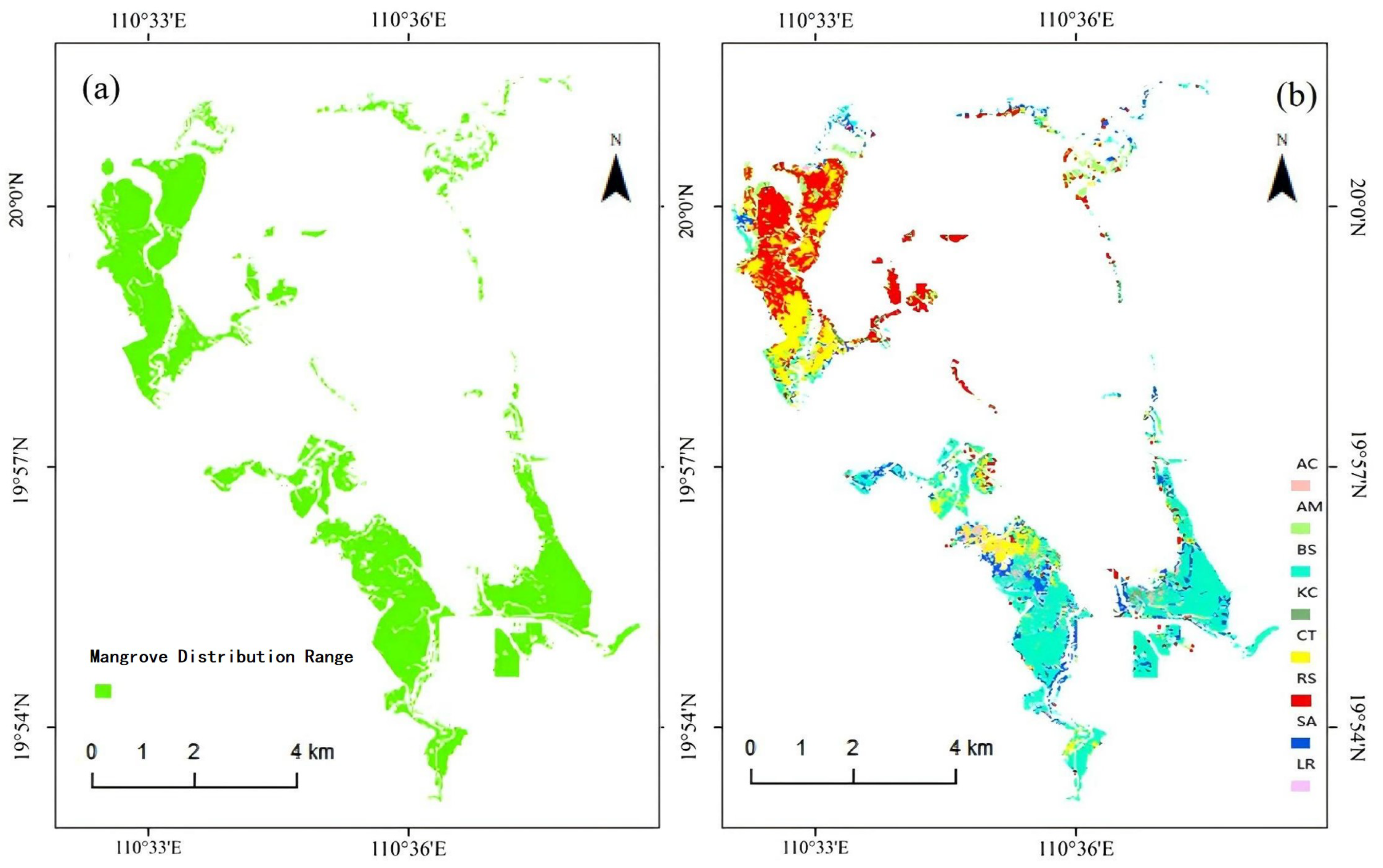
- Spatial Trend Analysis of Dongzhaigang Mangroves:Using GEE remote sensing imagery and the FFS-RF classification model, this study mapped the mangrove distribution in Dongzhaigang. The results showed a total mangrove area of 1837.18 hectares (ha) in 2020, with a classification accuracy of 97.13%. The main species identified include Bruguiera sexangula, Bruguiera sexangular rhynchopetala (BS-BG), Rhizophora stylosa (RS), and Ceriops tagal (CT), among others. The spatial distribution of biomass and carbon stocks revealed an increasing trend from the coast to the inland, with higher values in the south and lower in the north, providing valuable data for carbon-stock estimation and species conservation.
2. Material and Method
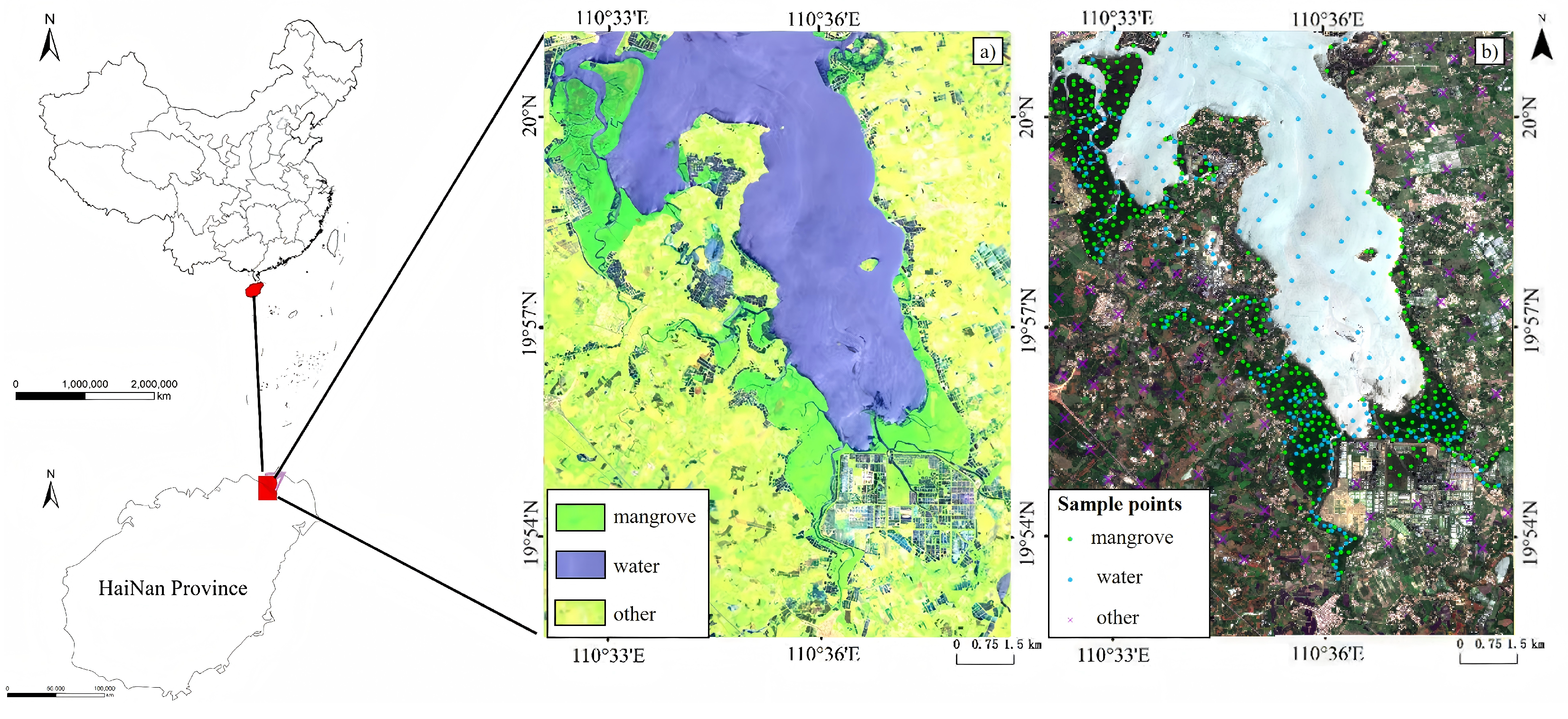
2.1. Study Area
2.2. Remote Sensing Data and Preprocessing
2.2.1. Optical Dataset Collection
2.2.2. Radar Data Collection
2.2.3. Data Preprocessing
2.3. Method
2.3.1. Feature Introduction for Mangrove Species Classification
2.3.2. Inter-Species Classification Based on Forward Feature Selection Combined with the Random Forest
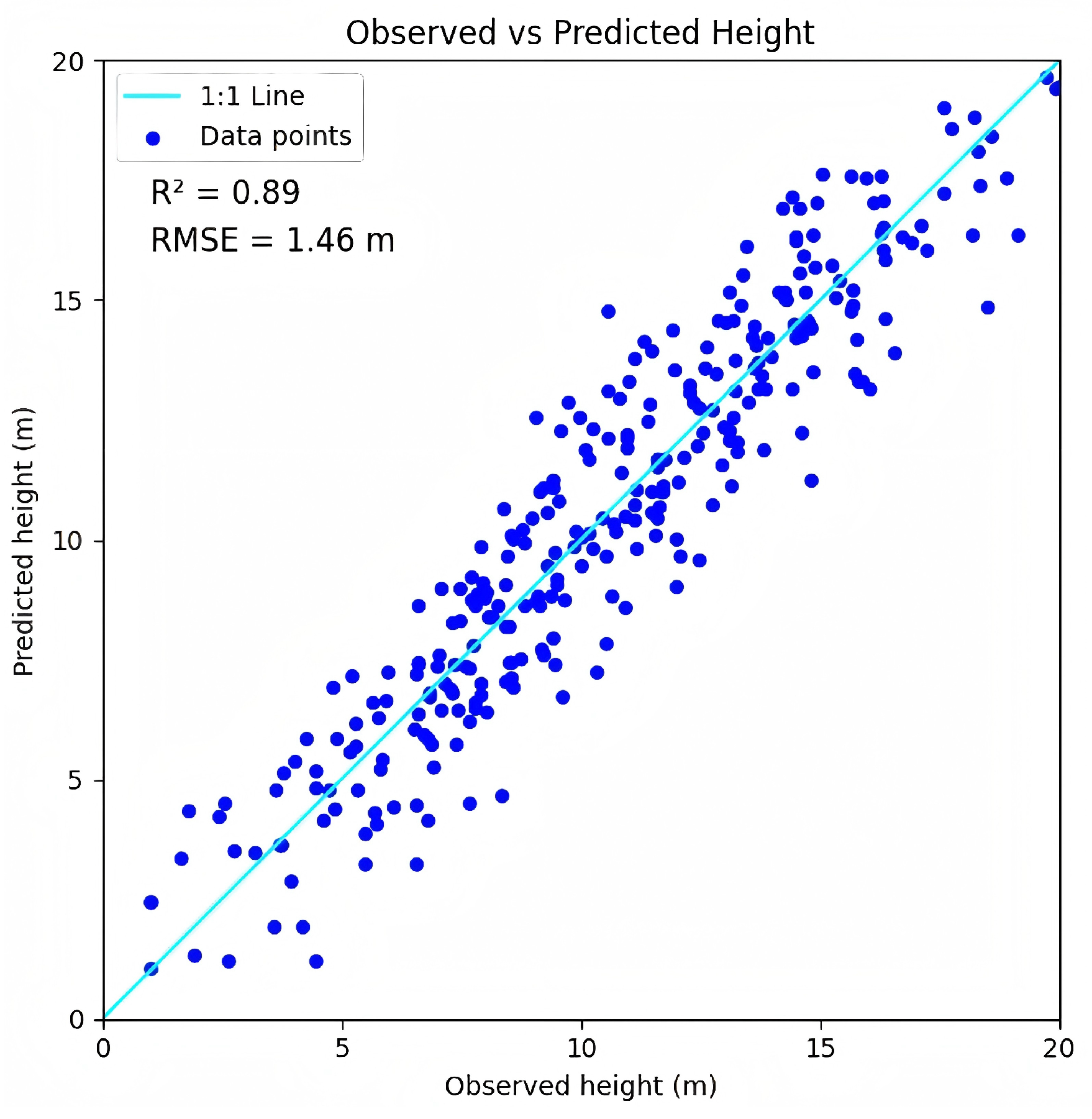
2.3.3. Incorporating Canopy-Height Extrapolation Using GEDI and Sentinel-2
2.3.4. Establishment of the Biomass Model
2.3.5. Carbon-Stock Estimation
2.3.6. Evaluation Metrics
3. Results
3.1. Spatial Distribution and Fine-Grained Classification Results of Mangroves in Dongzhaigang
3.2. Mangrove Distribution and Species Classification Results
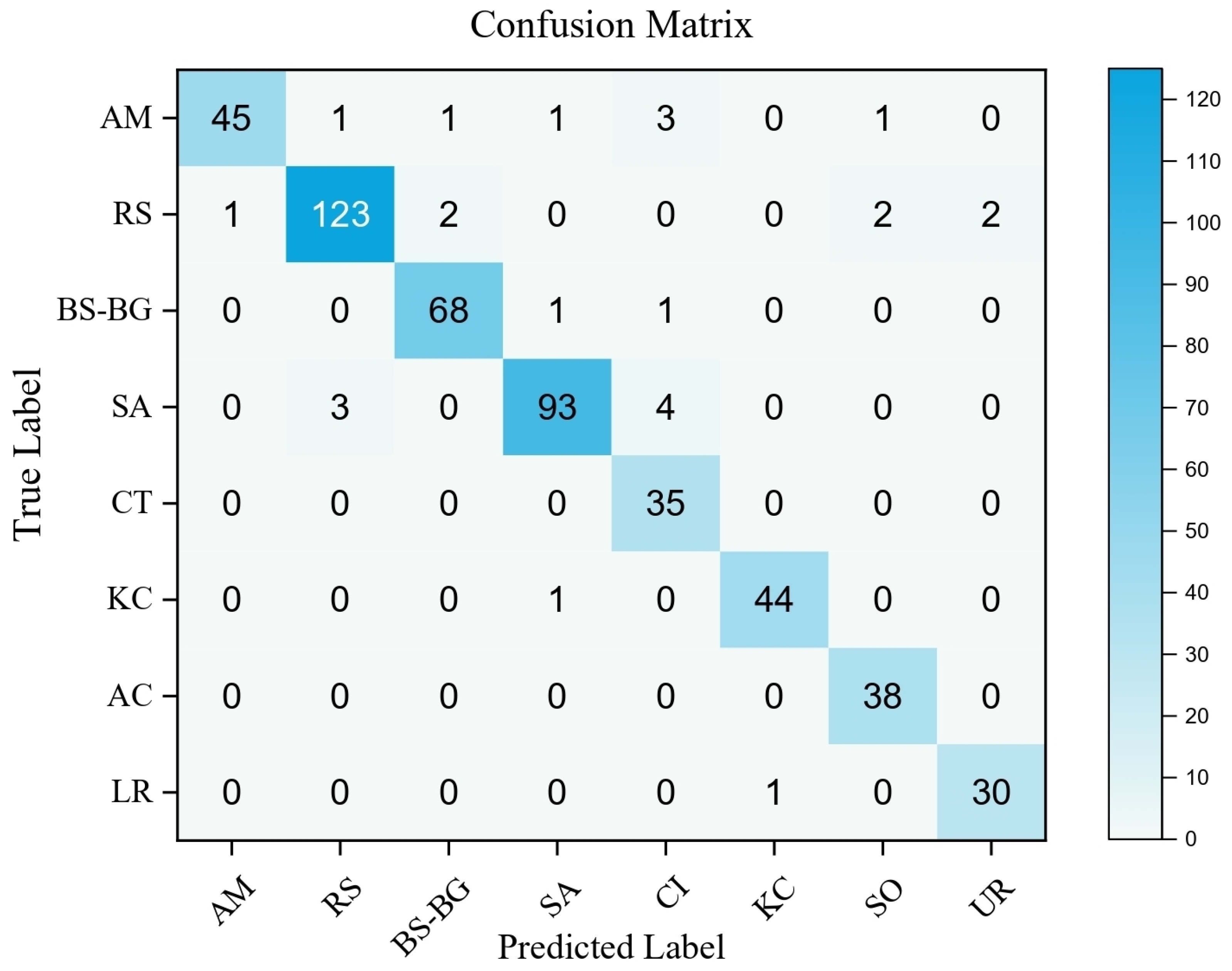
3.2.1. Mangrove Distribution Extraction and RF Classification Model Validation
3.2.2. Mangrove Species Classification and Spatial Distribution Analysis
3.3. Spatial Distribution Patterns of Biomass and Carbon Storage in Mangrove Forests of Dongzhaigang and Their Ecological Function Evaluation
4. Disscussion
4.1. Key Findings
4.2. Limitations and Potential of the Study
5. Conclusions
Author Contributions
Funding
Institutional Review Board Statement
Informed Consent Statement
Data Availability Statement
Acknowledgments
Conflicts of Interest
References
- Duarte, C.M.; Losada, I.J.; Hendriks, I.E.; Mazarrasa, I.; Marbà, N. The role of coastal plant communities for climate change mitigation and adaptation. Nat. Clim. Change 2013, 3, 961–968. [Google Scholar] [CrossRef]
- Goldberg, L.; Lagomasino, D.; Thomas, N.; Fatoyinbo, T. Global declines in human-driven mangrove loss. Glob. Change Biol. 2020, 26, 5844–5855. [Google Scholar] [CrossRef] [PubMed]
- Rahman, M.M.; Zimmer, M.; Ahmed, I.; Donato, D.; Kanzaki, M.; Xu, M. Co-benefits of protecting mangroves for biodiversity conservation and carbon storage. Nat. Commun. 2021, 12, 3875. [Google Scholar] [CrossRef]
- Donato, D.C.; Kauffman, J.B.; Murdiyarso, D.; Kurnianto, S.; Stidham, M.; Kanninen, M. Mangroves among the most carbon-rich forests in the tropics. Nat. Geosci. 2011, 4, 293–297. [Google Scholar] [CrossRef]
- Shi, X.; Wu, L.; Zheng, Y.; Zhang, X.; Wang, Y.; Chen, Q.; Sun, Z.; Nie, T. Dynamic Estimation of Mangrove Carbon Storage in Hainan Island Based on the InVEST-PLUS Model. Forests 2024, 15, 750. [Google Scholar] [CrossRef]
- Meng, Y.; Bai, J.; Gou, R.; Cui, X.; Feng, J.; Dai, Z.; Diao, X.; Zhu, X.; Lin, G. Relationships between above- and below-ground carbon stocks in mangrove forests facilitate better estimation of total mangrove blue carbon. Carbon Balance Manag. 2021, 16, 8. [Google Scholar] [CrossRef]
- Meng, Y.; Gou, R.; Bai, J.; Moreno-Mateos, D.; Davis, C.C.; Wan, L.; Song, S.; Zhang, H.; Zhu, X.; Lin, G. Spatial patterns and driving factors of carbon stocks in mangrove forests on Hainan Island, China. Glob. Ecol. Biogeogr. 2022, 31, 1692–1706. [Google Scholar] [CrossRef]
- Jia, K.; Chen, S.S.; Jiang, W.G. Long time-series remote sensing monitoring of mangrove forests in the Guangdong-Hong Kong-Macao Greater Bay Area. Natl. Remote Sens. Bull. 2022, 26, 1096–1111. [Google Scholar] [CrossRef]
- Woodroffe, C.D. Studies of a mangrove basin, Tuff Crater, New Zealand: I. Mangrove biomass and production of detritus. Estuar. Coast. Shelf Sci. 1985, 20, 265–280. [Google Scholar] [CrossRef]
- Duke, N.C.; Meynecke, J.O.; Dittmann, S.; Ellison, A.M.; Anger, K.; Berger, U.; Cannicci, S.; Diele, K.; Ewel, K.C.; Field, C.D.; et al. A World Without Mangroves? Conserv. Biol. 2007, 21, 90–100. [Google Scholar] [CrossRef]
- Jachowski, N.R.A.; Quak, M.S.Y.; Friess, D.A.; Duangnamorn, D.; Webb, E.L.; Ziegler, A.D. Mangrove biomass estimation in Southwest Thailand using machine learning. Appl. Geogr. 2013, 45, 311–321. [Google Scholar] [CrossRef]
- Komiyama, A.; Ong, R.C.; Poungparn, S. Allometric equations for predicting above-ground biomass in mangrove forests. For. Ecol. Manag. 2008, 255, 3788–3796. [Google Scholar]
- Huang, C.; Zhang, C.; Li, H. Assessment of the Impact of Rubber Plantation Expansion on Regional Carbon Storage Based on Time Series Remote Sensing and the InVEST Model. Remote Sens. 2022, 14, 6234. [Google Scholar] [CrossRef]
- Piyathilake, I.D.U.H.; Udayakumara, E.P.N.; Ranaweera, L.V.; Gunatilake, S.K. Modeling predictive assessment of carbon storage using InVEST model in Uva province, Sri Lanka. J. Environ. Manag. 2022, 8, 2213–2223. [Google Scholar] [CrossRef]
- Pham, T.D.; Yokoya, N.; Bui, D.T.; Yoshino, K.; Friess, D.A. Remote Sensing Approaches for Monitoring Mangrove Species, Structure, and Biomass: Opportunities and Challenges. Remote Sens. 2019, 11, 230. [Google Scholar] [CrossRef]
- Sanam, H.; Thomas, A.A.; Kumar, A.P.; Lakshmanan, G. Multi-sensor Approach for the Estimation of Above-Ground Biomass of Mangroves. J. Indian Soc. Remote Sens. 2024, 52, 903–916. [Google Scholar] [CrossRef]
- Maurya, K.; Mahajan, S.; Chaube, N. Remote Sensing Techniques: Mapping and Monitoring of Mangrove Ecosystem—A Review. Complex Intell. Syst. 2021, 7, 2797–2818. [Google Scholar] [CrossRef]
- Tian, L.; Wu, X.; Tao, Y.; Li, M.; Qian, C.; Liao, L.; Fu, W. Review of Remote Sensing-Based Methods for Forest Aboveground Biomass Estimation: Progress, Challenges, and Prospects. Forests 2023, 14, 1086. [Google Scholar] [CrossRef]
- Li, L.; Zhou, B.; Liu, Y.; Wu, Y.; Tang, J.; Xu, W.; Wang, L.; Ou, G. Reduction in Uncertainty in Forest Aboveground Biomass Estimation Using Sentinel-2 Images: A Case Study of Pinus densata Forests in Shangri-La City, China. Remote Sens. 2023, 15, 559. [Google Scholar] [CrossRef]
- Wu, C.; Tao, H.; Zhai, M.; Lin, Y.; Wang, K.; Deng, J.; Shen, A.; Gan, M.; Li, J.; Yang, H. Using Nonparametric Modeling Approaches and Remote Sensing Imagery to Estimate Ecological Welfare Forest Biomass. J. For. Res. 2018, 29, 151–161. [Google Scholar] [CrossRef]
- Cao, Q.-X.; Xu, D.-P.; Ju, H.-B. Biomass Estimation of Five Kinds of Mangrove Community in Beibu Gulf Based on Remote Sensing. Guangxi Sci. 2011, 18, 289–293. [Google Scholar]
- Tian, Y.; Huang, H.; Zhou, G.; Zhang, Q.; Tao, J.; Zhang, Y.; Lin, J. Estimation of Aboveground Biomass of Mangroves in the Beibu Gulf Based on Machine Learning and UAV Remote Sensing. Sci. Total Environ. 2021, 772, 146816. [Google Scholar] [CrossRef]
- Mcleod, E.; Chmura, G.L.; Bouillon, S.; Salm, R.; Björk, M.; Duarte, C.M.; Silliman, B.R. A Blueprint for Blue Carbon: Toward an Improved Understanding of the Role of Vegetated Coastal Habitats in Sequestering CO2. Front. Ecol. Environ. 2011, 9, 552–560. [Google Scholar] [CrossRef]
- Alongi, D.M. Carbon Cycling and Storage in Mangrove Forests. Annu. Rev. Mar. Sci. 2014, 6, 195–219. [Google Scholar] [CrossRef] [PubMed]
- Simard, M.; Fatoyinbo, L.; Smetanka, C.; Rivera-Monroy, V.H.; Castañeda-Moya, E.; Thomas, N.; Van der Stocken, T. Mangrove Canopy Height Globally Related to Precipitation, Temperature and Cyclone Frequency. Nat. Geosci. 2019, 12, 40–45. [Google Scholar] [CrossRef]
- Sanderman, J.; Hengl, T.; Fiske, G.J.; Cheney, E.; O’Rourke, S. A Global Map of Mangrove Forest Soil Carbon at 30 m Spatial Resolution. Environ. Res. Lett. 2018, 13, 055002. [Google Scholar] [CrossRef]
- Atwood, T.B.; Connolly, R.M.; Almahasheer, H.; Carnell, P.E.; Duarte, C.M.; Ewers Lewis, C.J.; Lovelock, C.E. Global Patterns in Mangrove Soil Carbon Stocks and Losses. Nat. Clim. Change 2017, 7, 523–528. [Google Scholar] [CrossRef]
- Kuenzer, C.; Bluemel, A.; Gebhardt, S.; Vo Quoc, T.; Dech, S. Remote Sensing of Mangrove Ecosystems: A Review. Remote Sens. 2011, 3, 878–928. [Google Scholar] [CrossRef]
- Alongi, D.M. Carbon Sequestration in Mangrove Forests. Carbon Manag. 2014, 3, 313–322. [Google Scholar] [CrossRef]
- Zhang, F.; Yang, X. Improving land cover classification in an urbanized coastal area by random forests: The role of variable selection. Remote Sens Environ. 2020, 251, 112105. [Google Scholar] [CrossRef]
- Kumar, L.; Sinha, P. Mapping Saltmarsh Vegetation Using High-Spatial and Hyperspectral Satellite Data to Assist Wetland Inventory. ISPRS J. 2014, 94, 228–243. [Google Scholar]
- Fatoyinbo, T.E.; Simard, M. Height and Biomass of Mangroves in Africa from ICESat/GLAS and SRTM. Int. J. Remote Sens. 2013, 34, 668–681. [Google Scholar] [CrossRef]
- Yang, Y.; Meng, Z.; Zu, J.; Cai, W.; Wang, J.; Su, H.; Yang, J. Fine-Scale Mangrove Species Classification Based on UAV Multispectral and Hyperspectral Remote Sensing Using Machine Learning. Remote Sens. 2024, 16, 3093. [Google Scholar] [CrossRef]
- Aye, W.N.; Tong, X.; Li, J.; Wunna Tun, A. Assessing the Carbon Storage Potential of a Young Mangrove Plantation in Myanmar. Forests 2023, 14, 824. [Google Scholar] [CrossRef]
- Zhen, J.; Liao, J.; Shen, G. Mapping Mangrove Forests of Dongzhaigang Nature Reserve in China Using Landsat 8 and Radarsat-2 Polarimetric SAR Data. Sensors 2018, 18, 4012. [Google Scholar] [CrossRef] [PubMed]
- Hancock, S.; Marselis, S.; Dubayah, R.; Hofton, M.; Tang, H.; Sun, X. GEDI Waveform Processing for Forest Biomass Estimation. Remote Sens. Environ. 2021, 255, 112276. [Google Scholar]
- Tang, H.; Armston, J.; Hancock, S.; Marselis, S.; Goetz, S.J.; Dubayah, R. Characterizing Global Forest Canopy Structure Using Spaceborne Lidar. Remote Sens. Environ. 2019, 231, 111262. [Google Scholar] [CrossRef]
- Duncanson, L.; Neuenschwander, A.; Hancock, S.; Thomas, N.; Fatoyinbo, T.; Simard, M.; Silva, C.A.; Armston, J.; Luthcke, S.B.; Hofton, M.; et al. Biomass Estimation from Simulated GEDI, ICESat-2 and NISAR Across Environmental Gradients in Sonoma County, California. Remote Sens. Environ. 2020, 242, 111779. [Google Scholar] [CrossRef]
- Hu, T.; Zhang, Y.; Su, Y.; Zheng, Y.; Lin, G.; Guo, Q. Mapping the Global Mangrove Forest Aboveground Biomass Using Multisource Remote Sensing Data. Remote Sens. 2020, 12, 1690. [Google Scholar] [CrossRef]
- Li, H.; Jia, M.; Zhang, R.; Ren, Y.; Wen, X. Incorporating the Plant Phenological Trajectory into Mangrove Species Mapping with Dense Time Series Sentinel-2 Imagery and the Google Earth Engine Platform. Remote Sens. 2019, 11, 2479. [Google Scholar] [CrossRef]
- Zhou, M.; Xu, A.; Yang, C.; Liang, L. Mangrove Information Extraction and Precision Analysis Based on Multi-Feature Combination. Am. J. Remote Sens. 2023, 11, 36–43. [Google Scholar] [CrossRef]
- Iranzad, R.; Liu, X. A Review of Random Forest-Based Feature Selection Methods for Data Science Education and Applications. Int. J. Data Sci. Anal. 2024. [Google Scholar] [CrossRef]
- Pelletier, C.; Valero, S.; Inglada, J.; Champion, N.; Dedieu, G. Assessing the Robustness of Random Forests to Map Land Cover with High Resolution Satellite Image Time Series over Large Areas. Remote Sens. Environ. 2016, 187, 156–168. [Google Scholar] [CrossRef]
- Pereira, F.R.D.; Kampel, M.; Soares, M.L.G.; Estrada, G.C.D.; Bentz, C.; Vincent, G. Reducing Uncertainty in Mapping of Mangrove Aboveground Biomass Using Airborne Discrete Return Lidar Data. Remote Sens. 2018, 10, 637. [Google Scholar] [CrossRef]
- Ali, N.; Khati, U. Forest Aboveground Biomass and Forest Height Estimation Over a Sub-Tropical Forest Using Machine Learning Algorithm and Synthetic Aperture Radar Data. J. Indian Soc. Remote Sens. 2024, 52, 771–786. [Google Scholar] [CrossRef]
- Satyanarayana, B.; Muslim, A.M.; Horsali, N.A.I.; Zauki, N.A.M.; Otero, V.; Nadzri, M.I.; Ibrahim, S.; Husain, M.-L.; Dahdouh-Guebas, F. Status of the Undisturbed Mangroves at Brunei Bay, East Malaysia: A Preliminary Assessment Based on Remote Sensing and Ground-Truth Observations. Peer J. 2018, 6, e4397. [Google Scholar] [CrossRef]
- Baloloy, A.B.; Blanco, A.C.; Sta. Ana, R.R.C.; Nadaoka, K. Development and Application of a New Mangrove Vegetation Index (MVI) for Rapid and Accurate Mangrove Mapping. ISPRS J. Photogramm. Remote Sens. 2020, 166, 95–117. [Google Scholar] [CrossRef]
- Xu, H. Modification of Normalized Difference Water Index (NDWI) to Enhance Open Water Features in Remotely Sensed Imagery. Int. J. Remote Sens. 2006, 27, 3025–3033. [Google Scholar] [CrossRef]
- Jia, M.M. Remote Sensing Analysis of China’s Mangrove Forests Dynamics During to 2013. Ph.D. Dissertation, Northeast Institute of Geography and Agroecology, Chinese Academy of Sciences, Changchun, China, 2014. [Google Scholar]
- Behera, M.D.; Barnwal, S.; Paramanik, S.; Das, P.; Bhattyacharya, B.K.; Jagadish, B.; Roy, P.S.; Ghosh, S.M.; Behera, S.K. Species-Level Classification and Mapping of a Mangrove Forest Using Random Forest Utilisation of AVIRIS-NG and Sentinel Data. Remote Sens. 2021, 13, 2027. [Google Scholar] [CrossRef]
- Kamal, M.; Phinn, S.; Johansen, K. Object-based approach for multi-scale mangrove composition mapping using multi-resolution image datasets. Remote Sens. 2015, 7, 4753–4783. [Google Scholar] [CrossRef]
- Diniz, C.G.; Souza-Filho, P.W.M.; Silva, M.G.S. Topographic influence on mangrove vegetation detected by ALOS/PALSAR imagery and SRTM data in Amazon Coastal Plain. Remote Sens. 2019, 11, 70. [Google Scholar]
- Green, E.P.; Mumby, P.J.; Clark, C.D.; Edwards, T.M. Remote Sensing Handbook for Tropical Coastal Management, 1st ed.; UNESCO Publishing: Paris, France, 2000; pp. 1–316. [Google Scholar]
- Haralick, M.; Shanmugam, K.; Dinstein, I. Textural Features for Image Classification. TSMC 1973, 3, 610–621. [Google Scholar] [CrossRef]
- Kacic, P.; Hirner, A.; Da Ponte, E. Fusing Sentinel-1 and -2 to Model GEDI-Derived Vegetation Structure Characteristics in GEE for the Paraguayan Chaco. Remote Sens. 2021, 13, 5105. [Google Scholar] [CrossRef]
- Xu, C.; Morgenroth, J.; Manley, B. Integrating Data from Discrete Return Airborne LiDAR and Optical Sensors to Enhance the Accuracy of Forest Description: A Review. Curr. For. Rep. 2015, 1, 206–219. [Google Scholar] [CrossRef]
- Wicaksono, P.; Danoedoro, P.; Hartono, U.; Nehren, U. Mangrove Biomass Carbon Stock Mapping of the Karimunjawa Islands Using Multispectral Remote Sensing. Int. J. Remote Sens. 2016, 37, 26–52. [Google Scholar] [CrossRef]
- Saenger, P.; Snedaker, S.C. Pantropical Trends in Mangrove Above-Ground Biomass and Annual Litterfall. Oecologia 1993, 96, 293–299. [Google Scholar] [CrossRef]
- Zhang, H.; Chen, G.; Liu, Z.; Zhang, S.Y. Study on the Mangrove Wetland Ecosystem in Futian, Shenzhen; Guangdong Science and Technology Press: Guangzhou, China, 1998; pp. 15–40. [Google Scholar]
- Li, C.; Cai, H.; Yan, X. Analysis of Changes in Carbon Budget of Mangrove Wetlands in Dongzhai Harbor, Hainan from 2010 to 2018. Bull. Mar. Sci. 2020, 39, 488–497. [Google Scholar]
- Xin, K.; Yan, K.; Gao, C.; Li, Z. Carbon storage and its influencing factors in Hainan Dongzhagang mangrove wetlands. Mar. Freshw. Res. 2018, 69, 771–779. [Google Scholar] [CrossRef]
- Cao, J.; Leng, W.; Liu, K.; Liu, L.; He, Z.; Zhu, Y. Object-Based Mangrove Species Classification Using Unmanned Aerial Vehicle Hyperspectral Images and Digital Surface Models. Remote Sens. 2018, 10, 89. [Google Scholar] [CrossRef]
- Hu, J.; Xin, K.; Li, Z.; Gao, C.; Yan, K. Carbon Storage and Sequestration Function Evaluation in Dongzhaigang Mangrove Reserve of Hainan. Wetl. Sci. 2015, 13, 338–343. [Google Scholar]
- Huang, X.; Wang, X.P.; Li, X.Z.; Xin, K.; Yan, Z.Z.; Sun, Y.G.; Bellerby, R. Distribution Pattern and Influencing Factors for Soil Organic Carbon (SOC) in Mangrove Communities at Dongzhaigang, China. J. Coast. Res. 2018, 34, 434–442. [Google Scholar] [CrossRef]
- Wang, X.; Tan, L.; Fan, J. Performance Evaluation of Mangrove Species Classification Based on Multi-Source Remote Sensing Data Using Extremely Randomized Trees in Fucheng Town, Leizhou City, Guangdong Province. Remote Sens. 2023, 15, 1386. [Google Scholar] [CrossRef]
- Mengistu, F.; Hailu, B.T.; Abera, T.A.; Heiskanen, J.; Zeleke, T.T.; Johansson, T.; Pellikka, P. Improving the accuracy of honey bee forage class mapping using ensemble learning and multi-source satellite data in Google Earth Engine. Sci. Afr. 2024, 26, e02415. [Google Scholar] [CrossRef]
- Marcílio, W.E.; Eler, D.M. From Explanations to Feature Selection: Assessing SHAP Values as Feature Selection Mechanism. In Proceedings of the 33rd SIBGRAPI Conference on Graphics, Patterns and Images (SIBGRAPI 2020), Porto de Galinhas, Brazil, 7–10 November 2020; IEEE: Porto de Galinhas, Brazil, 2020; pp. 340–347. [Google Scholar]
- Razavi-Termeh, S.V.; Sadeghi-Niaraki, A.; Seo, M.B.; Choi, S.-M. Application of genetic algorithm in optimization parallel ensemble-based machine learning algorithms to flood susceptibility mapping using radar satellite imagery. Sci. Total Environ. 2023, 873, 162285. [Google Scholar] [CrossRef]
- Belgiu, M.; Dragut, L. Random forest in remote sensing: A review of applications and future directions. Isprs J. 2016, 114, 24–31. [Google Scholar] [CrossRef]
- Shataee, S.; Kalbi, S.; Fallah, A.; Pelz, D. Forest attribute imputation using machine-learning methods and ASTER data: Comparison of k-NN, SVR and random forest regression algorithms. Int. J. Remote Sens. 2012, 33, 6254–6280. [Google Scholar] [CrossRef]
- Chen, H.; Qin, Z.; Zhai, D.-L.; Ou, G.; Li, X.; Zhao, G.; Fan, J.; Zhao, C.; Xu, H. Mapping Forest Aboveground Biomass with MODIS and Fengyun-3C VIRR Imageries in Yunnan Province, Southwest China Using Linear Regression, K-Nearest Neighbor and Random Forest. Remote Sens. 2022, 14, 5456. [Google Scholar] [CrossRef]
- Ren, C.; Jiang, H.; Xi, Y.; Liu, P.; Li, H. Quantifying Temperate Forest Diversity by Integrating GEDI LiDAR and Multi-Temporal Sentinel-2 Imagery. Remote Sens. 2023, 15, 375. [Google Scholar] [CrossRef]
- Hemati, M.; Mahdianpari, M.; Shiri, H.; Mohammadimanesh, F. Integrating SAR and Optical Data for Aboveground Biomass Estimation of Coastal Wetlands Using Machine Learning: Multi-Scale Approach. Remote Sens. 2024, 16, 831. [Google Scholar] [CrossRef]
- Wang, D.; Wan, B.; Qiu, P.; Zuo, Z.; Wang, R.; Wu, X. Mapping Height and Aboveground Biomass of Mangrove Forests on Hainan Island Using UAV-LiDAR Sampling. Remote Sens. 2019, 11, 2156. [Google Scholar] [CrossRef]
- Li, W.; Xue, Z.; Zhu, J.; Tian, Z. Estimating Carbon Storage of Mangroves on Hainan Island Based on Multi-Source Remote Sensing Data from the Google Earth Engine (GEE) Platform. Remote Sens. Nat. Resour. 2024; in press. Available online: https://link.cnki.net/urlid/10.1759.P.20240424.1642.010 (accessed on 26 April 2024).
- Wen, X.; Liu, K.; Cao, J.; Zhu, Y.; Wang, Z. Estimation of Mangrove Aboveground Biomass in China Using Forest Canopy Height through an Allometric Equation. Trop. Geogr. 2023, 43, 1–11. [Google Scholar]
- Bai, J.; Meng, Y.; Gou, R.; Lyu, J.; Dai, Z.; Diao, X.; Zhang, H.; Luo, Y.; Zhu, X.; Lin, G. Mangrove diversity enhances plant biomass production and carbon storage in Hainan island, China. Funct. Ecol. 2021, 35, 774–786. [Google Scholar] [CrossRef]


| Sentinel-2 Feature | Feature Name | Formula/Definition | Reference |
|---|---|---|---|
| Band Features | Single Band | B2, B3, B4, B5, B6, B7, B8, B11, B12 | - |
| Spectral Features | NDVI | [46] | |
| NDWI | [46] | ||
| NDMI | [46] | ||
| MVI | [47] | ||
| MNDWI | [48] | ||
| EVI | [46] | ||
| IMFI | [49] | ||
| DVI | [28] | ||
| RENDVI | [50] | ||
| Topographic Features | slope, elevation, shade, aspect | [51,52,53] | |
| Texture Features | Contrast | [54] | |
| Correlation | [54] | ||
| IDM | [54] | ||
| Variance | [54] |
| Species | AGB (t/hm2) | BGB (t/hm2) |
|---|---|---|
| AC | 137.85 | 67.55 |
| AM | 29.92 | 14.66 |
| BS-BG | 165.38 | 81.04 |
| CT | 53.09 | 26.01 |
| LR | 37.23 | 18.24 |
| KC | 79.84 | 39.12 |
| RS | 116.08 | 56.88 |
| SA | 130.13 | 63.76 |
| Species | (t C/ha) | (t C/ha) | (t C/ha) | (t C/ha) | (t C/ha) |
|---|---|---|---|---|---|
| AC | 62.86 | 30.77 | 7.25 | 5.49 | 176.62 |
| AM | 63.18 | 40.88 | 8.2 | 5.49 | 199.74 |
| BS-BG | 75.41 | 31.98 | 107.1 | 5.49 | 219.46 |
| CT | 24.82 | 13.91 | 54.3 | 5.49 | 98.52 |
| LR | 26.14 | 14.95 | 48.5 | 5.49 | 95.08 |
| KK | 61.96 | 32.25 | 81.4 | 5.49 | 180.11 |
| RS | 52.94 | 31.98 | 42.3 | 5.49 | 139.16 |
| SG | 29.33 | 18.15 | 42.5 | 5.49 | 130.96 |
| Method | Overall Accuracy | Kappa Coefficient | Reference |
|---|---|---|---|
| Random Forest | 84% | 0.84 | [40] |
| Support Vector Machine | 88.66% | 0.871 | [62] |
| Maximum Likelihood Classification | 80% | 0.714 | [46] |
| FFS-RF | 92.01% | 0.8974 | This study |
| Category | Predicted as Non-Mangrove | Predicted as Mangrove | Total | UA (%) | PA (%) |
|---|---|---|---|---|---|
| Non-Mangrove | 340 | 10 | 350 | 97.70 | 97.14 |
| Mangrove | 8 | 392 | 400 | 97.51 | 98.00 |
| Total | 348 | 402 | 750 | - | - |
| OA (%) | 97.13 | ||||
| Kappa | 0.9517 | ||||
| BS-BG | CT | KC | RS | SA | AC | AM | LR | |
|---|---|---|---|---|---|---|---|---|
| Area (ha) | 663.05 | 298 | 64.78 | 403.5 | 202 | 69.43 | 128.2 | 8.22 |
| Area ratio (%) | 36.09% | 16.22% | 3.53% | 21.96% | 10.99% | 3.78% | 6.98% | 0.45% |
| Total AGB (t) | 109,655.21 | 15,815.82 | 5172.36 | 46,828.08 | 26,290.26 | 9574.07 | 3835.74 | 306.34 |
| Average total carbon stock (t/C ha) | 219.46 | 135.38 | 120.96 | 135.16 | 130.96 | 176.62 | 115.82 | 90.7 |
| Carbon stock (t) | 145,521.99 | 40,333.24 | 7836.97 | 54,552.06 | 26,454.92 | 12,261.12 | 14,852.92 | 745.55 |
| Carbon ratio (%) | 48.10% | 13.33% | 2.59% | 18.03% | 8.74% | 4.05% | 4.91% | 0.25% |
Disclaimer/Publisher’s Note: The statements, opinions and data contained in all publications are solely those of the individual author(s) and contributor(s) and not of MDPI and/or the editor(s). MDPI and/or the editor(s) disclaim responsibility for any injury to people or property resulting from any ideas, methods, instructions or products referred to in the content. |
© 2025 by the authors. Licensee MDPI, Basel, Switzerland. This article is an open access article distributed under the terms and conditions of the Creative Commons Attribution (CC BY) license (https://creativecommons.org/licenses/by/4.0/).
Share and Cite
Zhang, R.; Fan, J. Classification and Carbon-Stock Estimation of Mangroves in Dongzhaigang Based on Multi-Source Remote Sensing Data Using Google Earth Engine. Remote Sens. 2025, 17, 964. https://doi.org/10.3390/rs17060964
Zhang R, Fan J. Classification and Carbon-Stock Estimation of Mangroves in Dongzhaigang Based on Multi-Source Remote Sensing Data Using Google Earth Engine. Remote Sensing. 2025; 17(6):964. https://doi.org/10.3390/rs17060964
Chicago/Turabian StyleZhang, Ruiwen, and Jianchao Fan. 2025. "Classification and Carbon-Stock Estimation of Mangroves in Dongzhaigang Based on Multi-Source Remote Sensing Data Using Google Earth Engine" Remote Sensing 17, no. 6: 964. https://doi.org/10.3390/rs17060964
APA StyleZhang, R., & Fan, J. (2025). Classification and Carbon-Stock Estimation of Mangroves in Dongzhaigang Based on Multi-Source Remote Sensing Data Using Google Earth Engine. Remote Sensing, 17(6), 964. https://doi.org/10.3390/rs17060964