Abstract
A spaceborne microwave radiometer has a low spatial resolution limited by its antenna size. Enhancing the spatial resolution of data acquired by such sensors can improve the quality of subsequent applications. To improve the spatial resolution of the Microwave Radiation Imager (MWRI) onboard the Fengyun 3D satellite, this study used a Scatterometer Image Reconstruction (SIR) algorithm to generate resolution-enhanced swath brightness temperature data based on redundant information from overlaps between scanning points. These swath data have a higher pixel resolution that can reach 1/4 of the sampling frequency. The quality of reconstructed images, evaluated through visual comparison and quantitative analysis, revealed reasonable potential for providing more detailed depictions of surface information. Statistical analysis revealed a lower root mean square deviation of 0.8 K and a bias of 0.04 K following the SIR process. Analysis of the pixel spatial response function confirmed that the enhanced data have substantially finer spatial resolution than that of Level-1 data for 10–89 GHz vertical/horizontal channels, with an improvement of 9–39% in effective resolution. The findings of this study show that the SIR algorithm has potential for enhancing the quality of MWRI data and for widening the application domain to satellite product development, satellite data assimilation for numerical weather prediction, and other related fields.
1. Introduction
Passive microwave remote sensing technology, which is not impeded by clouds, plays important roles in Earth’s surface monitoring [1] and numerical weather prediction [2,3]. However, owing to limitations regarding the size and weight of their antennas, spaceborne microwave radiometers have restricted spatial resolution. For example, the Special Sensor Microwave/Imager (SSM/I) [4] and the Special Sensor Microwave Imager/Sounder (SSMIS) [5], carried on the Defense Meteorological Satellite Program series satellites, both have an antenna with a diameter of 0.61 × 0.66 m, providing ground resolutions of 13–69 and 13.2–73.6 km, respectively. NASA’s Earth Observing System (EOS) Aqua satellite, which was launched successfully in 2002, is equipped with the Advanced Microwave Scanning Radiometer for EOS (AMSR-E) [6]. AMSR-E, whose antenna diameter is 1.6 m, has a spatial ground resolution of 4–75 km. The Advanced Microwave Scanning Radiometer 2 (AMSR2) [7] onboard the Japan Aerospace Exploration Agency Global Change Observation Mission water cycle satellite [8,9], has a ground resolution of 3–62 km owing to its 2-meter-diameter antenna. The microwave imager onboard the Global Precipitation Measurement mission, which was launched in 2014, has a ground resolution of 4.4–32 km, consistent with its antenna diameter of 1.2 m [10].
Several methods have been developed to overcome the problem of resolution. Available enhanced-resolution products are mainly generated using the two most popular methods: the Backus–Gilbert (BG) algorithm [11,12,13,14] and the Scatterometer Image Reconstruction (SIR) algorithm [15]. Both methods improve spatial resolution based on redundant information resulting from the overlapped area of sensor footprints. Generally, the larger the overlapped area, the better the resolution enhancement. The BG algorithm is an inversion method based on the principle of the least-squares method. It uses a linear combination of nearby measurements () to estimate the brightness temperature at a certain point (i.e., ). The BG algorithm has been applied successfully in relation to several spaceborne instruments, e.g., AMSR-E, the Scanning Multichannel Microwave Radiometer, SSM/I, and SSMIS [15,16,17,18,19]. The SIR algorithm was originally developed for reconstruction of imagery obtained by multiple scatterometers [16,20], but it was later applied to radiometer data. The SIR algorithm predicts the brightness temperature of a pixel based on maximum entropy estimation, followed by an iterative process that generates the final brightness temperature. Currently, the SIR algorithm has been used successfully in relation to the Soil Moisture Active Passive (SMAP) Radiometer, AMSR-E, SMMR, SSM/I, and SSMIS [15,21,22,23,24], and related products covering the period 1995–2022 are available to the public. In each iteration, the maximum entropy principle is used in the SIR algorithm to generate the brightness temperature of a pixel for the subsequent iteration [25,26].
In recent years, several enhanced-resolution passive microwave products have been made available to the public worldwide. To improve the quality of data records of passive microwave observations of Earth while ameliorating limitations on spatial resolution, the NASA MEaSUREs Calibrated Enhanced-Resolution Passive Microwave Daily Equal-Area Scalable Earth (EASE) Grid 2.0 Brightness Temperature Earth System Data Record [27] has generated consistently processed microwave brightness temperature (TB) image products spanning from 1987 to the present, including both conventional and enhanced-resolution products on 25-km and finer grids. The SMAP Radiometer Twice-Daily rSIR-Enhanced EASE Grid 2.0 Brightness Temperatures product has also provided conventional and enhanced-resolution images on both 25-km and finer grids as well as on the SMAP-standard 36-km and finer grids. Unlike the global gridded products mentioned above, the Microwave Radiation Imager (MWRI) resolution-enhanced data are stored in the swath format without map projection. The data are available in swath form and are therefore applicable to processes with short timescales and avoid errors caused by projection. This study used the MWRI L1 swath brightness temperature product to produce swath-based resolution-enhanced TB data by applying the SIR algorithm, from which enhanced-resolution soil moisture [23], snow depth [28], soil freeze/thaw status [29], and land surface temperature data [30] can be derived.
In this paper, we consider the suitability of the SIR algorithm for generating enhanced-resolution brightness temperature images from MWRI data and analyze the performance of the reconstruction. The remainder of the paper is organized as follows. Section 2 introduces the data and methodology. Actual MWRI data results, the performance of the reconstruction, and the related discussion are presented in Section 3. Finally, the derived conclusions are provided in Section 4.
2. Materials and Methods
2.1. Data
Fengyun-3D (FY-3D) is the fourth polar orbiting meteorological satellite of the FY-3 series, launched on 15 November 2017 [31,32,33,34]. FY-3D operates at an orbital height of 836 km, with a repeat period of 5.5 days. FY-3D has an afternoon orbit, whose local time of ascending/descending node is at 14:00/02:00. MWRI is one of the most important instruments onboard the FY-3D satellite. It has capabilities and design specifications similar to those of several predecessors, working at frequencies of 10.65–89 GHz with vertical (V) and horizontal (H) polarization. It can complete continuous all-weather observations of Earth, operating at an essentially constant incidence angle of approximately 53° over a 1400-km-wide swath. The size of the Earth view window is and remains constant among various channels (Figure 1). It utilizes a conical scanning mode with a scan rate of 35.3 scan/min that produces a ground footprint with a constant area corresponding to the same frequency of observations. MWRI has four separate feed horns for 10.65, 18.7/23.8, 36.5, and 89 GHz. Different channels share a single offset reflector antenna with a diameter of 90 cm. Table 1 lists the channel characteristics of MWRI. The size of the 3 dB footprint decreases with increasing channel frequency, and the ground resolution varies within the range of 7.5–85 km. The 10 GHz V/H channels are most sensitive to areas of surface roughness and soil dielectric constant. The 19 GHz V/H channels are sensitive to the microwave radiation characteristics of ice and snow. The 24 GHz V/H channels are available for the measurement of atmospheric water vapor, and the 37 GHz V/H channels are designed to detect cloud liquid water content. The 89 GHz V/H channels are sensitive to scattering signals from hydrometeors in the solid phase.
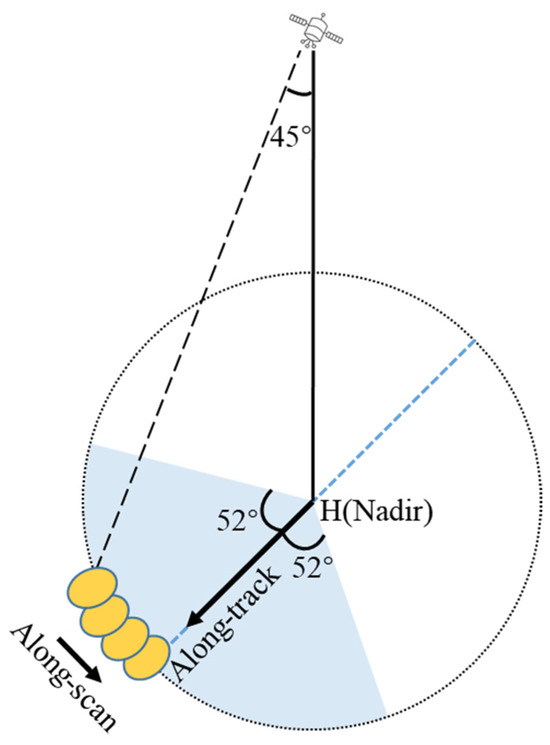
Figure 1.
Illustration of MWRI observing the Earth. The arrow indicates the scanning direction, and the blue area represents the Earth view window.

Table 1.
Size of the 3 dB footprint for all channels of the FY-3D MWRI.
Figure 2 and Table 2 show the 3 dB measurement footprint of different MWRI channels and the percentage overlaps. Overlapping occurs for all channels in both the along-track and along-scan directions. For channels at 10 GHz, the rate of overlap can reach 80%, which indicates great potential for resolution enhancement. However, for 89 GHz channels, only a 17.07% overlap exists in the along-scan direction, and 14.75% in the along-track direction. Considering the percentage overlap of less than 30%, the effective resolution may not be improved for 89 GHz channels.
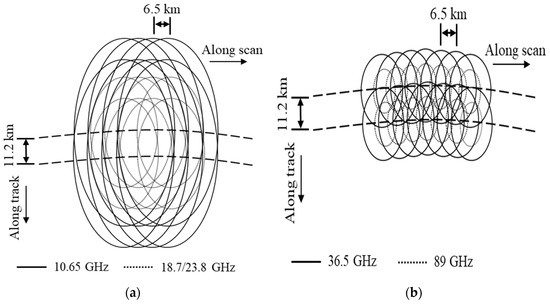
Figure 2.
3 dB measurement footprint of channels at (a) 10.65 and 18.7/23.8 GHz (b) 36.5 and 89 GHz. The size of the footprint at 23.8 GHz is similar to that at 18.7 GHz. The arrows to the right represent the along-scan direction, and the downward arrows represent the along-track direction.
Table 2.
Percentage overlaps among channels.
The input data used for this study were obtained from the FY-3D/MWRI Level-1 product, which contains brightness temperature, data location, and quality information. The data are available on the website of the National Satellite Meteorological Center of the China Meteorological Administration (http://satellite.nsmc.org.cn, accessed on 1 January 2025). A quality control scheme has been designed to remove abnormal streaky signals on the edge and invalid observations caused by factors such as equipment, weather conditions, and underlying surfaces. The quality control procedures of the data include two parts: (1) the limb check, which rejects the samples near the right edge of each scanline; and (2) the gross value check, which rejects the samples with filling values in their latitude, longitude, azimuth, zenith, or brightness temperature. The MWRI resolution-enhanced data are derived from single-swath data, produced separately for ascending and descending passes, and then stored in swath format without map projection.
2.2. Methodology
2.2.1. Theoretical Basis
The MWRI TB is determined by the effective brightness temperature of Earth’s surface, as well as the atmospheric emission, scattering, and attenuation. Due to the temporal and spatial variability of surface brightness, which is affected by the soil, overlying vegetation, surface temperatures, and snowpack [35,36,37], it is hard to derive individual components from the observed brightness temperature. Generally speaking, the radiometric measurement is dominated by surface emissivity and temperature, vegetation canopy, scan angle, and atmospheric parameters [38]. Measurements of brightness temperature can be written in integral form as the product of the effective brightness temperature of pixels and the antenna gain pattern over the surface area of the antenna. Here, “pixel” is from the finer swath grid that can reach 1/4 of the sampling frequency through the orbit interpolation method. The integral equation is expressed as follows [15]:
where (x, y) are the local coordinates on the ground, which is tangent to Earth’s surface fixed to the same measurement point, while using the projection of the antenna pattern at the surface. is the i-th antenna temperature measurement, is the effective brightness temperature at (x, y), and is the antenna gain pattern at (x, y). Normalized antenna patterns projected on Earth’s surface are illustrated in Figure 3. The antenna footprints can be treated as ellipses of different sizes. The x-axis and y-axis represent the major semi-axis and minor semi-axis of the elliptical footprint, respectively. From Figure 3, we can see that the actual antenna patterns are not a continuous function but a two-dimensional jump function with low resolution. The patterns are discretized into several coarse-grained meshes, especially for the 36.5 and 89 GHz channels (Figure 3c,d). This hardly meets the pixel resolution required by the enhanced data. Therefore, a two-dimensional normalized Gaussian function was used for fitting the pattern in order to generate continuous functions for matching the locations of all pixels.
where a and b are the fitting coefficients derived from the antenna patterns. This model is in good agreement with the actual antenna pattern, with the average relative deviation lower than 0.00048 K, and the standard deviation lower than 0.008 K.
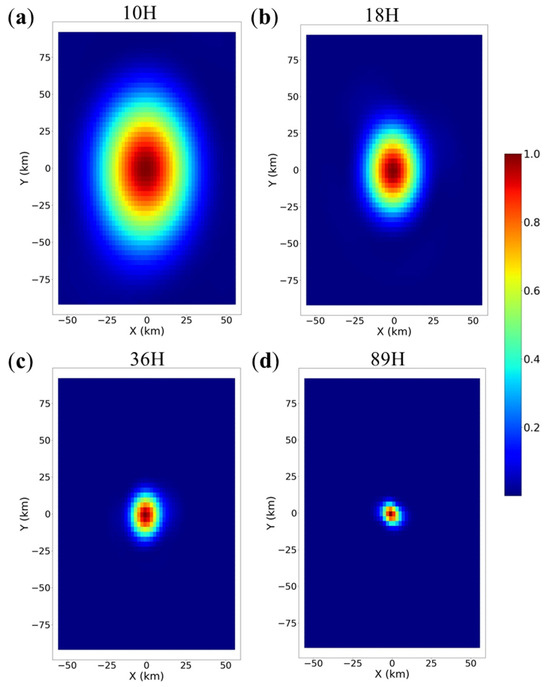
Figure 3.
Normalized MWRI antenna pattern projected on Earth’s surface: (a) 10.65 H channel; (b) 18.7 H channel; (c) 36.5 H channel; (d) 89 H channel.
2.2.2. Spatial Matching
The satellite location vector S in Earth-centered, Earth-fixed coordinates was calculated as follows [39]:
where is the longitude of the measurement point, is the latitude of the measurement point; and E, N, and U represent the east axis, north axis, and up axis of the local East, North, and Up (ENU) Cartesian coordinate system, which is formed from a plane tangent to Earth’s surface fixed to the same specific location. The satellite location in ENU coordinates fixed to the measurement point F can be expressed as follows:
where and are the azimuthal angle and polar angle of the satellite, and R is the radial distance of the satellite. The vector F in Earth-centered, Earth-fixed coordinates is given by the following [39]:
where h is the height of the measurement point, is the prime vertical radius of curvature at the measurement point, and a and b are the semi-major and semi-minor axes, respectively, for the defined Earth ellipsoid.
As shown in Figure 4, the plane passing through point F, perpendicular to , intersects with at point H. Based on geometric relationships, the coordinates of point H and the footprint coverage area can be derived.
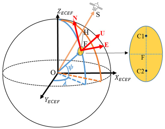
Figure 4.
Positional relation between the satellite, the observation point, and the ground footprint.
The spatial matching process requires considerable computational resources, with computing time increasing exponentially owing to multiplication of the number of pixels. We adopted various strategies to reduce the overall computing time required. On the one hand, a lookup table was built to store matching results between pixels, measurement points, and ground footprints before an iterative process. On the other hand, a local block search method was developed to substantially reduce the time consumed.
2.2.3. SIR Algorithm
The integral formula of in Equation (1) can be written in summed form, where is denoted by and is denoted by , i is the measurement number, and n is the pixel number. For the k-th iteration and the i-th measurement, the estimate of surface brightness temperature is computed as follows [15,21]:
Then, the scale factor is given by the following equation:
The nonlinear term is updated as follows:
For the k+1-th iteration, each pixel is computed by a weighted average of the nonlinear term:
where is number of measurements that cover the pixel. As the iteration number k increases, the scale factor approaches unity.
3. Results
3.1. SIR Simulation
To determine the appropriate number of iterations, we subjected actual MWRI data to SIR simulation. Deviation was formulated as the difference in brightness temperature between the SIR-enhanced and nonenhanced data:
where d stands for deviation, is the weighted average of brightness temperatures with SIR-enhancement at (x, y), and represents the observed values of brightness temperature at (x, y). With increasing iteration, the change in brightness temperature from iteration to iteration decreases after each iteration as the brightness temperature converges to a particular value.
Plotting the mean deviation and root mean square (RMS) deviation as a function of the iteration number (Figure 5) can help determine the appropriate number of iterations [21]. It is evident that the RMS deviation of all channels initially declines rapidly and then attains stability. The mean deviation initially increases rapidly and then gradually stabilizes with an increase in the number of iterations. We selected a value of 50 iterations for the following calculations because stable convergence occurs for both the mean deviation and the RMS deviation within 50 iterations. The variation in deviation at a lower frequency is larger than that at a higher frequency because the former channels have better resolution enhancement. The curve of the 18H channel is different from that of the other channels, i.e., its RMS deviation is obviously larger than that of other channels at the initiation point.
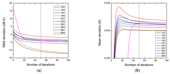
Figure 5.
SIR simulation deviation versus number of iterations for all channels: (a) RMS deviation and (b) mean deviation. The dashed line represents 50 iterations.
3.2. MWRI Data with the SIR Algorithm
We compared the performance of the nonenhanced and SIR-enhanced images of FY-3D/MWRI data. These images were extracted from the full half-orbit images using the selected algorithm parameters derived from the SIR simulation. The northeastern Tibetan Plateau was selected as the study region because it contains varied topography and many lakes. Subjectively, the SIR images have a higher contrast and appear to show more detail than that found in the nonenhanced images. It is revealed that the effective resolution varies between channels, with the highest frequency channels (i.e., with the smallest 3 dB footprint) providing the finest resolution. Comparison of the nonenhanced and SIR-enhanced images for the 18.7V, 36.5V, and 89H channels reveals that Qinghai Lake and Gyaring Lake (in the red square) both have much clearer outlines in the SIR-enhanced images (Figure 6f–h). The enhanced result of the 10.65H channel (Figure 6e) presents an area with a lower brightness temperature (Longyangxia reservoir) than that of the surrounding area (in the red circle), which is consistent with the higher frequency channels (Figure 6b–d); the same phenomenon does not exist in the nonenhanced image (Figure 6a). Visual comparison suggests that the spatial resolution of TB images in the land area can be improved effectively through SIR reconstruction. Additionally, there are clear improvements in the geolocation of Qinghai Lake through enhancement, which results from the sharpening of images over the mixed surface type, and the suppression of geolocation deviations owing to the integration of information from surrounding measurements.
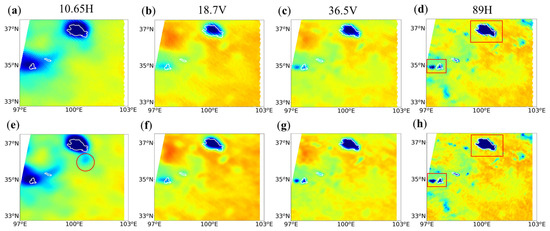
Figure 6.
Images of the northeastern Tibetan Plateau acquired on 1 September 2022 at 18: 59 (UTC): (a–d) nonenhanced images and (e–h) SIR-enhanced images corresponding to 10.65 H, 18.7 V, 36.5 V, and 89 H channels from left to right (k = 50). The red squares represent Qinghai Lake and Gyaring Lake, and the red circle represents a region of lower brightness temperature (Longyangxia reservoir).
The previous results were based on inland areas; here, we focus on offshore areas. Figure 7 shows nonenhanced and SIR-enhanced brightness temperature images of Typhoon Wutip, acquired on 23 February 2019 at 03:03 (UTC), derived from actual FY-3D/MWRI data. Visual comparison reveals improved detail in the SIR-enhanced images compared with that in the nonenhanced images. It is evident that the SIR-enhanced images (Figure 7d,e) have higher contrast and appear to show more detail of the typhoon structure than is found in the nonenhanced images (Figure 7a,b). The former, at lower frequency channels, also show features reasonably consistent with those of the latter at higher frequency channels, which have higher intrinsic resolution. For example, an area within the red rectangle shows brightness temperatures that are notably higher than those of the surrounding area, whereas the same phenomenon does not exist in the nonenhanced image. The results illustrate that this algorithm is reasonable for enhancing the resolution of MWRI data in ocean regions.
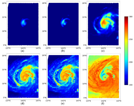
Figure 7.
Images of Typhoon Wutip acquired on 23 February 2019 at 03:03 (UTC): (a) nonenhanced 10 H, (b) SIR-enhanced 10 H (k = 50), and (c) nonenhanced 18 H channels; and (d) nonenhanced 36.5 H, (e) SIR-enhanced 36.5 H (k = 50), and (f) nonenhanced 89 H channels.
3.3. Statistical Analysis of Deviation
Figure 8a,b shows global daily enhanced brightness temperature images derived from actual FY-3D/MWRI data acquired on 1 September 2022. Owing to the lack of ground truth brightness temperature data, the errors could not be computed directly. Therefore, the deviation between the SIR-enhanced images and the original Level-1 data is provided to verify the rationality of the reconstruction results. As shown in Figure 8c,d, we calculated the global population of deviation to analyze the reliability of the reconstruction results. Generally, the absolute deviation is not greater than 2 K, and the deviations of the 18.7 V channel are significantly larger than those of the 36.5 V channel. Small deviations are evident in inland regions and in areas covered by a single type of surface composition, e.g., Greenland, which is covered by ice and snow throughout the year. Conversely, high absolute values are mainly distributed over land–water border areas, such as northern Canada and Western Europe, where many islands are located. The distribution of deviation was calculated for all channels for further study (Figure 9). Broadly, most values of deviation fall in the range from −2 to +2 K, which means that the results derived using the SIR algorithm show reasonable reliability in terms of reconstruction. The full width at half height of the distribution curve gradually diminishes with increasing frequency because lower frequencies, with a higher overlap rate in sampling, have a more obvious degree in terms of the enhancement of spatial resolution, which results in the enlargement of noise. The bandwidth of distribution for V-polarization channels is narrower than that for H-polarization channels, which indicates that the former produces a lower deviation during the reconstruction process. Moreover, the small shift of 0.04 K in the positive direction for all channels indicates that there is an overall positive bias in SIR-enhanced results.
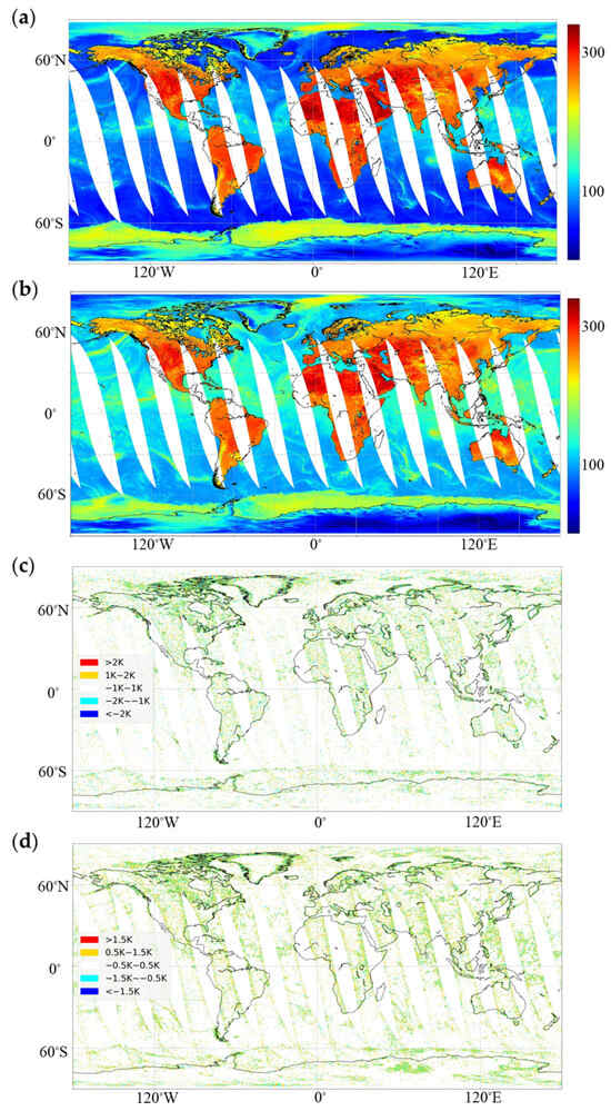
Figure 8.
Global SIR-enhanced brightness temperature image and deviation distribution diagram on 1 September 2022: (a) global SIR-enhanced TB image for the 18.7 V channel (iteration = 50); (b) global SIR-enhanced TB image for the 36.5 V channel (iteration = 50); (c) deviation distribution diagram for the 18.7 V channel; and (d) deviation distribution diagram for the 36.5 V channel. Due to scatters with high density in (c,d), gold spots and cyan spots that are close enough will show a green color visually, even though they are not overlapped and transparent.
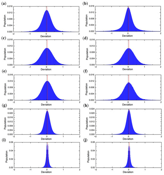
Figure 9.
Distribution of deviation for all channels: (left column) horizontal (H) polarization and (right column) vertical (V) polarization. Black dashed lines in (a–j) indicate the positions where deviation is zero; red lines indicate mean deviation. (Top to bottom) Channels at 10.65, 18.7, 23.8, 36.5, and 89 GHz.
The statistical characteristics of deviations can be used for comparison between channels. To analyze the performance of the results, we calculated the mean, RMS, and standard deviation (STD) of the brightness temperatures between SIR-enhanced and nonenhanced images. The images comprised half-orbit swath data (on 1 September 2022 at 04:37 (UTC)) with 266 × 1824 sample sizes. The RMS and STD values varied between channels, i.e., the values of both diminished with increasing frequency (Table 3). Owing to the reconstruction capability based on the overlap rate, the highest frequency channel (89 V) with the minimum overlap rate had the lowest values (0.112/0.104 K), and the lowest frequency channels (10 H) with the maximum overlap rate had the highest values (0.781/0.780 K). Additionally, the overall deviation performance of V-polarization channels was found to be better than that of H-polarization channels, and both had RMS deviations below the level of 0.6 K or 0.8 K. The mean deviation for all channels was located at approximately 0.04 K, consistent with the conclusion derived in the preceding paragraph.
Table 3.
Deviation statistics for a single day’s calculations (including 14 ascending swaths of 1 September 2022) for all channels (using the SIR algorithm with 50 iterations).
3.4. Noise Analysis
Due to the fact that resolution enhancement is usually accompanied by an increase in noise, we analyzed the impact of the SIR algorithm on noise amplification by comparing the signal-to-noise ratios (SNRs) between nonenhanced and enhanced results. We selected a spatially homogeneous region (from 67° W to 72° W, 5° S to 9° S) of the Amazon Basin to estimate the SNRs. A comparison of the SNRs is summarized in Table 4. The SIR algorithm has no evident influence on noise amplification, with a lower than 0.6 dB decrease in the SNR. Owing to the minimum overlap rate, the 89V/H channels have the maximum average reduction (−0.546 dB) in SNR. In particular, for the 18.7H channel, noise elimination appears after enhancement. Additionally, the SNR performance of the V-polarization channels was found to be better than that of the H-polarization channels, which is consistent with the deviation performance.
Table 4.
Comparison of SNRs between nonenhanced and enhanced results.
4. Effective Resolution Improvement
We evaluated the improvement in the effective resolution of images through computation of the pixel spatial response function (PSRF) [24,40], which depicts how much the whole brightness temperature of a pixel is contributed by each spatial location. The PSRF is the impulse response of the measurement and image formation system, including image formation from possibly multiple measurements of the same pixel. Thus, the effective resolution can be estimated from the investigation of the PSRF [40].
The study area comprised the southeastern coast of the Chinese mainland. Figure 10 shows the selected scanning line, together with the TB curves along the line that transit from land to ocean. The TB curves differ between the nonenhanced and SIR-enhanced data at the boundary because of differences in effective resolution. When the observation pixel approaches the boundary from the land side, a coarser pixel (corresponding to lower spatial resolution) reaches the ocean side earlier than a finer pixel (corresponding to higher spatial resolution), which results in an earlier reduction in the TB of the former. Similarly, when the observation pixel is further away from the boundary on the ocean side, a coarser pixel leaves land later than a finer pixel, which results in a later reduction in the TB of the former. Therefore, the higher the effective resolution, the steeper the decline of the TB curve. Based on this, it is evident that the SIR-enhanced results have notably higher effective resolutions than those of the nonenhanced results.
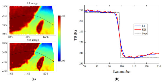
Figure 10.
(a) TB images over the study area for the 23V channel: (upper) from L1 data and (lower) from the SIR result. The black dashed line with an arrow indicates the selected scanning line and scanning direction. (b) Plots of TB along the selected transect lines. The blue line is the TB curve from Level-1 data, the red line is the TB curve from SIR-enhanced data, and the dashed line shows the step curve that is considered the ideal model. The average distance between two neighbor scan points is about 6.4 km.
A low-pass filter model was built to extract the main features of the TB curves based on the forward and inverse fast Fourier transform (FFT). Figure 11 shows the filtered results under different filter frequencies. The low-pass filter with a lower frequency can filter more smaller-scale fluctuations and make the curve smoother. As the frequency increases, the results of the filter become closer to the curve of the true observations. An appropriate frequency was chosen to both filter noise data and reflect the true TB change along the scanning line. As shown in Figure 11a,b, when the frequency is set to 0.05 or 0.1 Hz, the resultant curve has too much detail filtered out to reflect the real trend of change in the transition region. When the frequency is raised to 0.2 Hz, the corresponding curve can describe the changes in the transition region more truthfully, with some noise information removed at the same time. Therefore, the low-pass frequency was set at 0.2 Hz in this research.
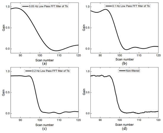
Figure 11.
Comparison between results of filters with different frequency characteristics for the 23 V channel. We chose the results of (a) 0.05 Hz, (b) 0.1 Hz, and (c) 0.2 Hz low-pass FFT filters for comparison with the (d) nonfiltered results.
We obtained the estimated one-dimensional PSRFs, as shown in Figure 12, by performing Fourier low-pass filtering on the TB curves at the coastline for data from both the Level-1 product and the SIR enhancement. The main lobe of each of the PSRF curves is close to the Gaussian function. The effective resolution is determined directly by the 3 dB bandwidth of the PSRF function. It is evident from Figure 12 that the 3 dB width of the PSRF of the SIR-enhanced results is narrower than that of the nonenhanced results, which indicates enhancement of resolution through SIR reconstruction. Table 5 presents the estimated resolutions for different channels. Overall, the SIR-enhanced results provide finer resolutions than the results obtained from the Level-1 product for the 10–36-GHz channels, with a 9–39% improvement in effective resolution. With increasing frequency, the percentage improvement in resolution first increases and then decreases. The resolution improvement was obtained by dividing the reduction of the 3 dB width by the 3 dB width of nonenhanced results. The 3 dB width decreases substantially with increasing frequency. Moreover, because a larger overlap leads to better enhancement, the reduction of the 3 dB width after reconstruction also decreases with increasing frequency. As a result, channels with a higher frequency have a smaller 3 dB width (smaller reduction of 3 dB width), which accounts for the increase (decrease) in improvement. As expected, the effective resolution of the images is coarser than the posting (image pixel spacing) resolution [40]. The precise improvement in resolution attributable to SIR is both sensor- and channel-dependent.
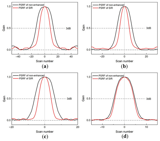
Figure 12.
Derived single-pass pixel spatial response functions (PSRFs) of SIR-enhanced and nonenhanced results for the (a) 10 V, (b) 18 V, (c) 23 V, and (d) 36 V channels. Black lines show the PSRFs of nonenhanced images, and red lines show the PSRFs of SIR-enhanced images. The upper and lower dashed lines represent the 3 dB threshold and the zero baseline, respectively.
Table 5.
Resolution estimated for different channels. The unit refers to the average distance between two neighboring scan points, which is about 6.4 km.
Considering that there is no resolution improvement and a more obvious decrease in SNR for 89 GHz channels, the enhanced data are recommended for applications in retrieving high-resolution maps of surface parameters that are sensitive to low-frequency signals, such as soil moisture [41], snowpack, and soil freeze/thaw status. Furthermore, the enhanced data may have the potential to provide more subgrid information for assimilation systems in NWP. In view of this, the evaluation of resolution-enhanced data applied to numerical models will be carried out in our future work.
5. Conclusions
This study focused on producing MWRI resolution-enhanced swath TB data whose pixel resolution reaches 1/4 of the sampling frequency. The quality control schemes used for MWRI were adopted to remove abnormal streaky signals and invalid observations caused by factors such as equipment and weather conditions. An important part of the preprocessing involved transformations and calculations of coordinates to ensure spatial matching between ground pixels and super-resolution grids. The SIR algorithm was employed to generate optimized TB data on finer swath grids. The optimal iteration time was determined based on a simulation of the deviation.
We evaluated the performance of the SIR algorithm using actual MWRI data. Visual interpretation of case study examples of the northeastern Tibetan Plateau and Typhoon Wutip revealed an improvement in resolution. Conservation of energy during reconstruction was confirmed by plotting the PDF of TB, which revealed that the enhanced results coincided well with the nonenhanced results. Statistical analysis of the deviation revealed that the SIR process realized a mean deviation of 0.04 K and a lower RMS deviation of 0.8 K. The effective resolution was determined by computing the PSRF. The SIR PSRF exhibited notably finer spatial resolution than that of the Level-1 data for the 10–36-GHz V/H channels, with an improvement of 9–39% in effective resolution for the SIR results compared with the nonenhanced results. The findings of this study demonstrate that the reconstruction of MWRI data using SIR can produce finer resolution. This algorithm will be employed in generating resolution-enhanced data for MWRI-II carried onboard the FY-3F satellite, which will be incorporated in a satellite chain with FY-3D to provide high-resolution passive microwave data in a timely and efficient manner.
Author Contributions
Conceptualization, Y.B. and Z.Z.; methodology, Y.B.; coding, Y.B. and J.S., validation, Y.B. and Z.Z.; formal analysis, Y.B., Z.Z., N.X., G.C. and H.X.; investigation, Y.B. and Z.Z.; resources, Z.Z., N.X. and G.C.; data curation, Y.B. and J.S.; original draft writing, Y.B. All authors have read and agreed to the published version of the manuscript.
Funding
This research was funded by the Marine Meteorological Comprehensive Support Phase II Project—Space-based Observation Subsystem Program (grant no. 202301JJ029), the National Natural Science Foundation of China (grant no. 42405160), and the China Meteorological Administration Innovation and Development Project (grant no. CXFZ2023J045).
Data Availability Statement
The data presented in this study are available on request from the corresponding author.
Acknowledgments
The MWRI Level-1 data for this paper were downloaded from http://satellite.nsmc.org.cn/PortalSite/Data/Sattelite.aspx, accessed on 1 January 2025. We thank the anonymous reviewers for providing valuable comments regarding our study. We also acknowledge helpful discussions with Shengli Wu, Pengjuan Yao, and Hanlie Xu.
Conflicts of Interest
Author Jie Shen was employed by the company Beijing HUAYUN ShineTek Technology Co., Ltd. The remaining authors declare that the research was conducted in the absence of any commercial or financial relationships that could be construed as a potential conflict of interest.
References
- Moncet, J.L.; Liang, P.; Galantowicz, J.F.; Lipton, A.E.; Uymin, G.; Prigent, C.; Grassotti, C. Land surface microwave emissivities derived from AMSR-E and MODIS measurements with advanced quality control. J. Geo-Phys. Res. Atmos. 2011, 116, D16104. [Google Scholar] [CrossRef]
- Yang, C.; Liu, Z.Q.; Bresch, J.; Rizvi, S.R.H.; Huang, X.Y.; Min, J.Z. 2016: AMSR2 all-sky radiance assimilation and its impact on the analysis and forecast of Hurricane Sandy with a limited-area data assimilation system. Tellus A 2016, 68, 30917. [Google Scholar] [CrossRef]
- Xiao, H.Y.; Han, W.; Wang, H.; Wang, J.C.; Liu, G.Q.; Xu, C.S. Impact of FY-3DMWRI radiance assimilation in GRAPES 4DVar on forecasts of typhoon Shanshan. J. Meteor. Res. 2020, 34, 836–850. [Google Scholar] [CrossRef]
- Hollinger, J.P.; Peirce, J.L.; Poe, G.A. SSM/I instrument evaluation. IEEE Trans. Geosci. Remote Sens. 1990, 28, 781–790. [Google Scholar] [CrossRef]
- Goodrum, G.; Kidwell, K.B.; Winston, W. NOAA KLM User’s Guide; Department of Commerce: Washington, DC, USA, 2000.
- Kawanishi, T.; Sezai, T.; Ito, Y.; Imaoka, K.; Takeshima, T.; Ishido, Y.; Shibata, A.; Miura, M.; Inahata, H.; Spencer, R.W. The advanced microwave scanning radiometer for the Earth observing system (AMSR-E), NASDA’S contribution to the EOS for global energy and water cycle studies. IEEE Trans. Geosci. Remote Sens. 2003, 41, 184–194. [Google Scholar] [CrossRef]
- Xiao, H.Y.; Han, W.; Bai, Y.H. Assimilation of GCOM-W AMSR2 radiance data in CMA_GFS 4DVar. Acta Meteorol. Sin. 2022, 80, 777–790. [Google Scholar]
- Oki, T.; Imaoka, K.; Kachi, M. AMSR instruments on GCOM-W1/2: Concepts and applications. In Proceedings of the 2010 IEEE International Geoscience and Remote Sensing Symposium, Honolulu, HI, USA, 25–30 July 2010. [Google Scholar]
- Kazumori, M.; Geer, A.J.; English, S.J. Effects of all-sky Effects of all-sky assimilation of GCOM-W/AMSR2 radiances in the ECMWF numerical weather prediction system. Quart J. Roy Meteor. Soc. 2016, 142, 721–737. [Google Scholar] [CrossRef]
- Lean, P.; Geer, A.J.; Lonitz, K. Assimilation of Global Precipitation Mission (GPM) Microwave Imager (GMI) in All-Sky Condition; ECMWF Technical Memoranda 799; ECMWF: Reading, UK, 2017. [Google Scholar]
- Backus, G.E.; Gilbert, J.F. Numerical applications of a formalism for geophysical inverse problems. Geophys. J. R. Astron. Soc. 1967, 13, 247–276. [Google Scholar] [CrossRef]
- Backus, G.E.; Gilbert, J.F. Resolving power of gross Earth data, Geophys. J. R. Astron. Soc. 1968, 16, 169–205. [Google Scholar] [CrossRef]
- Fleming, H. 1972: A method for calculating atmospheric thickness directly from satellite radiation measurements. In Proceedings of the Conference on Atmospheric Radiation, Ft Collins, CO, USA, 7–9 August 1972; pp. 134–137. [Google Scholar]
- Stogryn, A. Estimates of brightness temperature from scanning radiometer data. IEEE Trans. Antennas Propag. 1978, 26, 720–725. [Google Scholar] [CrossRef]
- Long, D.G.; Daum, D.L. Spatial resolution enhancement of SSM/I data. IEEE Trans. Geosci. Remote Sens. 1998, 36, 407–417. [Google Scholar] [CrossRef]
- Early, D.S.; Long, D.G. Image reconstruction and enhanced resolution imaging from irregular samples. IEEE Trans. Geosci. Remote Sens. 2001, 39, 291–302. [Google Scholar] [CrossRef]
- Gu, H.; England, A.W. AMSR-E data resampling with nearcircular synthesized footprint shape and noise/resolution tradeoff study. IEEE Trans. Geosci. Remote Sens. 2007, 45, 3193–3203. [Google Scholar]
- Poe, G.A. Optimum interpolation of imaging microwave radiometer data. IEEE Trans. Geosci. Remote Sens. 1990, 28, 800–810. [Google Scholar] [CrossRef]
- Gunn, B.A.; Long, D.G. Spatial resolution enhancement of AMSR Tb images based on measurement local time of day. In Proceedings of the IEEE IGARSS, Boston, MA, USA, 6–11 July 2008. [Google Scholar]
- Long, D.G.; Hardin, P.J.; Whiting, P.T. Resolution enhancement of spaceborne scattermeter data. IEEE Trans. Geosci. Remote Sens. 1993, 31, 700–715. [Google Scholar] [CrossRef]
- Long, D.G.; Brodzik, M.J. Optimum image formation for spaceborne microwave radiometer products. IEEE Trans. Geosci. Remote Sens. 2016, 54, 2763–2779. [Google Scholar] [CrossRef]
- Long, D.G.; Brodzik, M.J.; Hardman, M.A. Enhanced-resolution SMAP brightness temperature image products. IEEE Trans. Geosci. Remote Sens. 2019, 57, 4151–4163. [Google Scholar] [CrossRef]
- Brown, J.P.; Long, D.G. Resolution Enhancement of SMAP Passive Soil Moisture Estimates. Remote Sens. 2022, 14, 1761. [Google Scholar] [CrossRef]
- Long, D.G.; Brodzik, M.J.; Hardman, M. Evaluating the effective resolution of enhanced resolution SMAP brightness temperature image products. Front. Remote Sens. 2023, 4, 1073765. [Google Scholar] [CrossRef]
- Gordon, R. A tutorial on ART. IEEE Trans. Nucleon Sci. 1974, 21, 78–93. [Google Scholar] [CrossRef]
- Censor, Y. Finite series-expansion reconstruction methods. Proc. IEEE 1983, 71, 409–419. [Google Scholar] [CrossRef]
- Brodzik, M.J.; Long, D.G.; Hardman, M.A. Calibrated Passive Microwave Daily EASE-Grid 2.0 Brightness Temperature ESDR (CETB) Algorithm Theoretical Basis Document; NSIDC-0630, Version 2. [Data Set]; NASA National Snow and Ice Data Center Distributed Active Archive Center: Boulder, CO, USA, 2024. [CrossRef]
- Yang, J.; Jiang, L.; Wu, S.; Wang, G.; Wang, J.; Liu, X. Development of a snow depth estimation algorithm over China for the FY-3D/MWRI. Remote Sens. 2019, 11, 977. [Google Scholar] [CrossRef]
- Shao, W.; Zhang, T. Assessment of four near-surface soil freeze/thaw detection algorithms based on calibrated passive microwave remote sensing data over China. Earth Space Sci. 2020, 7, e2019EA000807. [Google Scholar] [CrossRef]
- Huang, C.; Zhang, S.; Han, W.; Feng, X.; Duan, S. Retrieval of cloudy land surface temperature from AMSR2 brightness temperature, precipitable water vapour and cloud liquid water. Int. J. Remote Sens. 2024, 45, 7518–7534. [Google Scholar] [CrossRef]
- Gu, S.Y.; Wang, Z.Z.; Li, J.; Zhang, S.W. The radiometric characteristics of sounding channels for FY-3A/MWHS. J. Appl. Meteor. Sci. 2010, 21, 335–341. (In Chinese) [Google Scholar]
- Guo, Y.; Lu, N.M.; Gu, S.; He, J.Y.; Wang, Z.Z. Radiometric characteristics of FY-3C microwave humidity and temperature sounder. J. Appl. Meteor. Sci. 2014, 25, 436–444. (In Chinese) [Google Scholar]
- Zhang, P.; Yang, H.; Qiu, H.; Ma, G.; Yang, Z.D.; Lu, N.M.; Yang, J. Quantitative remote sensing from the current Fengyun 3 satellites. Adv. Meteor. Sci. Technol. 2021, 2, 6–11. (In Chinese) [Google Scholar]
- Xian, D.; Zhang, P.; Gao, L.; Sun, R.J.; Zhang, H.Z.; Jia, X. Fengyun meteorological satellite products for earth system science applications. Adv. Atmos. Sci. 2021, 38, 267–1284. [Google Scholar] [CrossRef]
- Langlois, A.; Royer, A.; Dupont, F.; Roy, A.; Goita, K.; Picard, G. Improved corrections of forest effects on passive microwave satellite remote sensing of snow over boreal and subarctic regions. IEEE Trans. Geosci. Remote Sens. 2011, 49, 3824–3837. [Google Scholar] [CrossRef]
- Shahroudi, N.; Rossow, W. Using land surface microwave emissivities to isolate the signature of snow on different surface types. Remote Sens. Environ. 2014, 152, 638–653. [Google Scholar] [CrossRef]
- Xiao, X.; He, T.; Liang, S.; Zhao, T. Improving Fractional Snow Cover Retrieval from Passive Microwave Data Using a Radiative Transfer Model and Machine Learning Method. IEEE Trans. Geosci. Remote Sens. 2022, 60, 4304215. [Google Scholar] [CrossRef]
- Ulaby, F.T.; Long, D.G. Microwave Radar and Radiometric Remote Sensing; University of Michigan Press: Ann Arbor, MI, USA, 2013; ISBN 978-0-472-11935-6. [Google Scholar]
- Wang, L.; Tremblay, D.; Zhang, B.; Han, Y. Fast and accurate collocation of the visible infrared imaging radiometer suite measurements with cross-track infrared sounder. Remote Sens. 2016, 8, 76. [Google Scholar] [CrossRef]
- Long, D.G.; Brodzik, M.J.; Hardman, M.A. The Effective Resolution of CETB Image Products; NSIDC Special Report 21; National Snow and Ice Data Center: Boulder CO, USA, 2021. [Google Scholar]
- Kang, C.S.; Zhao, T.; Shi, J.; Cosh, M.H.; Chen, Y.; Starks, P.J.; Collins, C.H.; Wu, S.; Sun, R.; Zheng, J. Global soil moisture retrievals from the Chinese FY-3D Microwave Radiation Imager. IEEE Trans. Geosci. Remote Sens. 2021, 59, 4018–4032. [Google Scholar] [CrossRef]
Disclaimer/Publisher’s Note: The statements, opinions and data contained in all publications are solely those of the individual author(s) and contributor(s) and not of MDPI and/or the editor(s). MDPI and/or the editor(s) disclaim responsibility for any injury to people or property resulting from any ideas, methods, instructions or products referred to in the content. |
© 2025 by the authors. Licensee MDPI, Basel, Switzerland. This article is an open access article distributed under the terms and conditions of the Creative Commons Attribution (CC BY) license (https://creativecommons.org/licenses/by/4.0/).