


Regional-Scale Analysis of Soil Moisture Content in Malawi Determined by Remote Sensing

 , , , , , and
Abstract
1. Introduction
2. Data
2.1. Sentinel-1A
2.2. Moderate Resolution Imaging Spectroradiometer (MODIS)
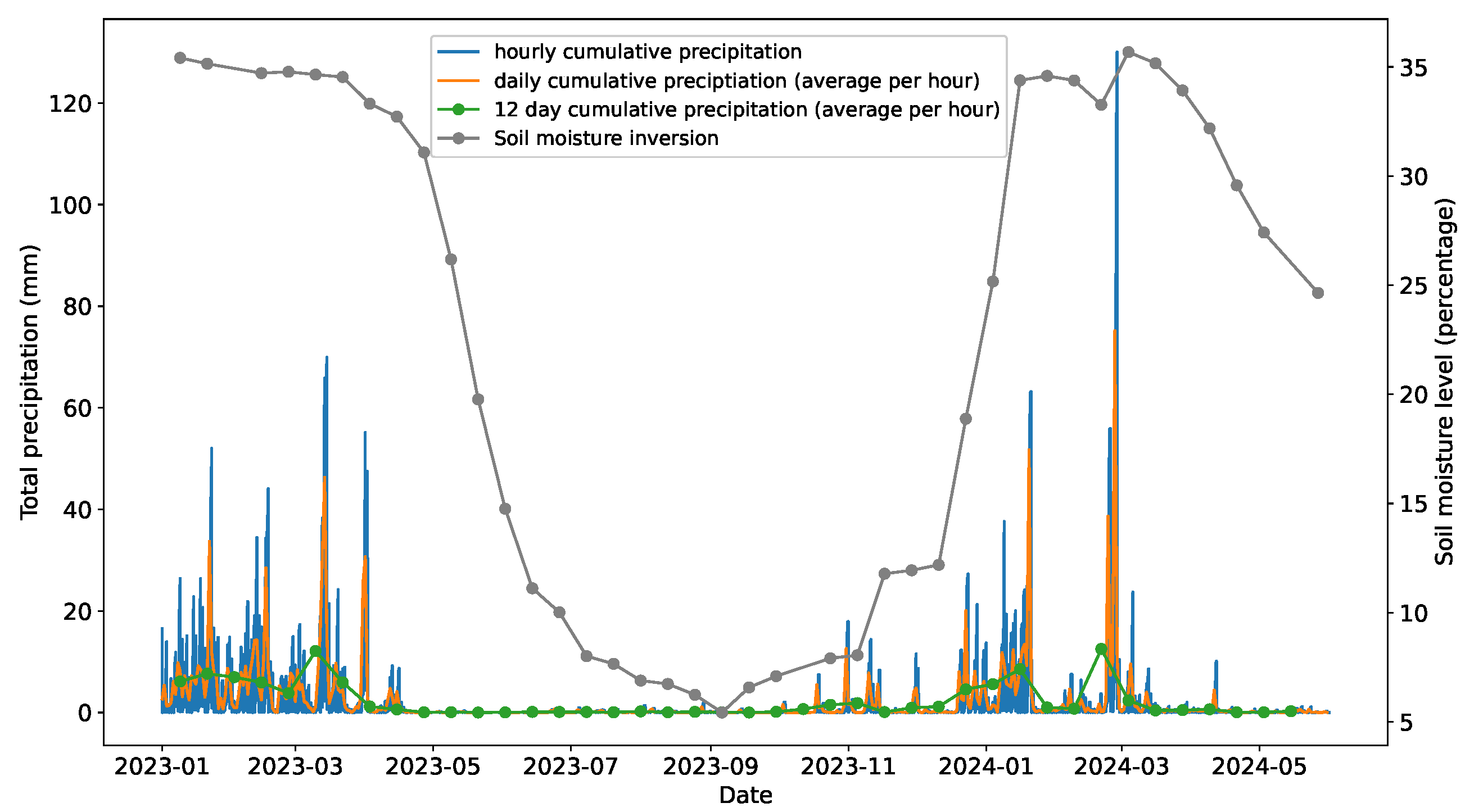
2.3. Meteorological and Soil Composition Data
3. Methods
Soil Moisture Monitoring
- Identify driest SAR acquisition. In order to solve the ambiguity of the soil moisture order described by De Zan and Gomba [9], the meteorological data from Section 2 were used to determine SAR acquisition dates with little to no precipitation. From these, the SAR acquisition with the highest mean coherence was chosen as the driest.
- Calculate coherence and phase closures. An SSM estimation grid was constructed and the interferometric coherence and phase closures calculated for each grid cell.
- Identify “dry” SAR acquisitions. Using the calculated coherence, the remaining SAR acquisitions were ordered in “dryness” starting from the driest acquisition identified earlier. The first 30% of acquisitions were labelled as “dry”.
- Calculate coherence due to SSM. The coherence from the “dry” acquisitions were used to determine the coherence loss due to soil moisture for all SSM grid cells.
- Invert to find SSM. An inversion from phase closures to soil moisture level was performed for each grid cell using the De Zan and Gomba [9] model.
4. Results
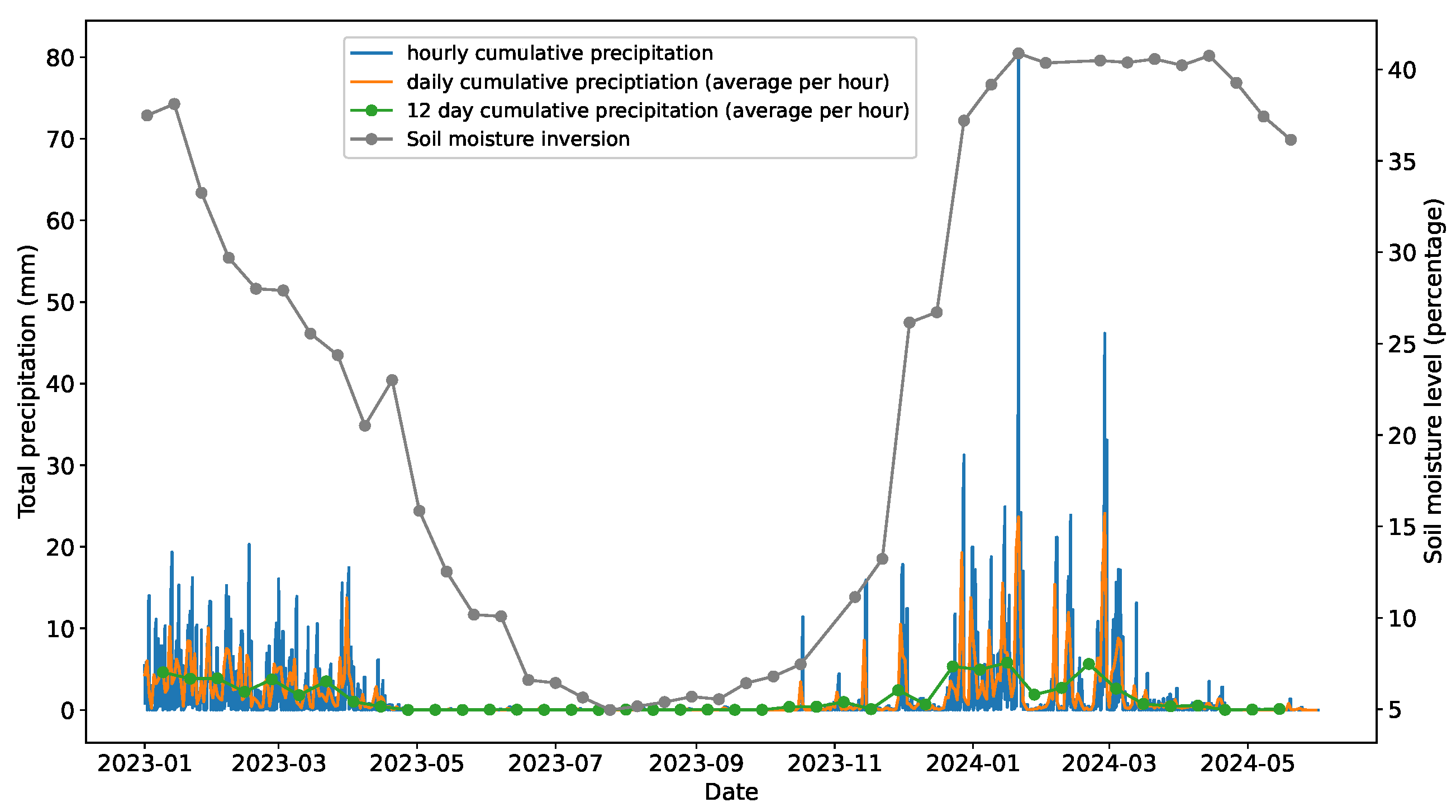
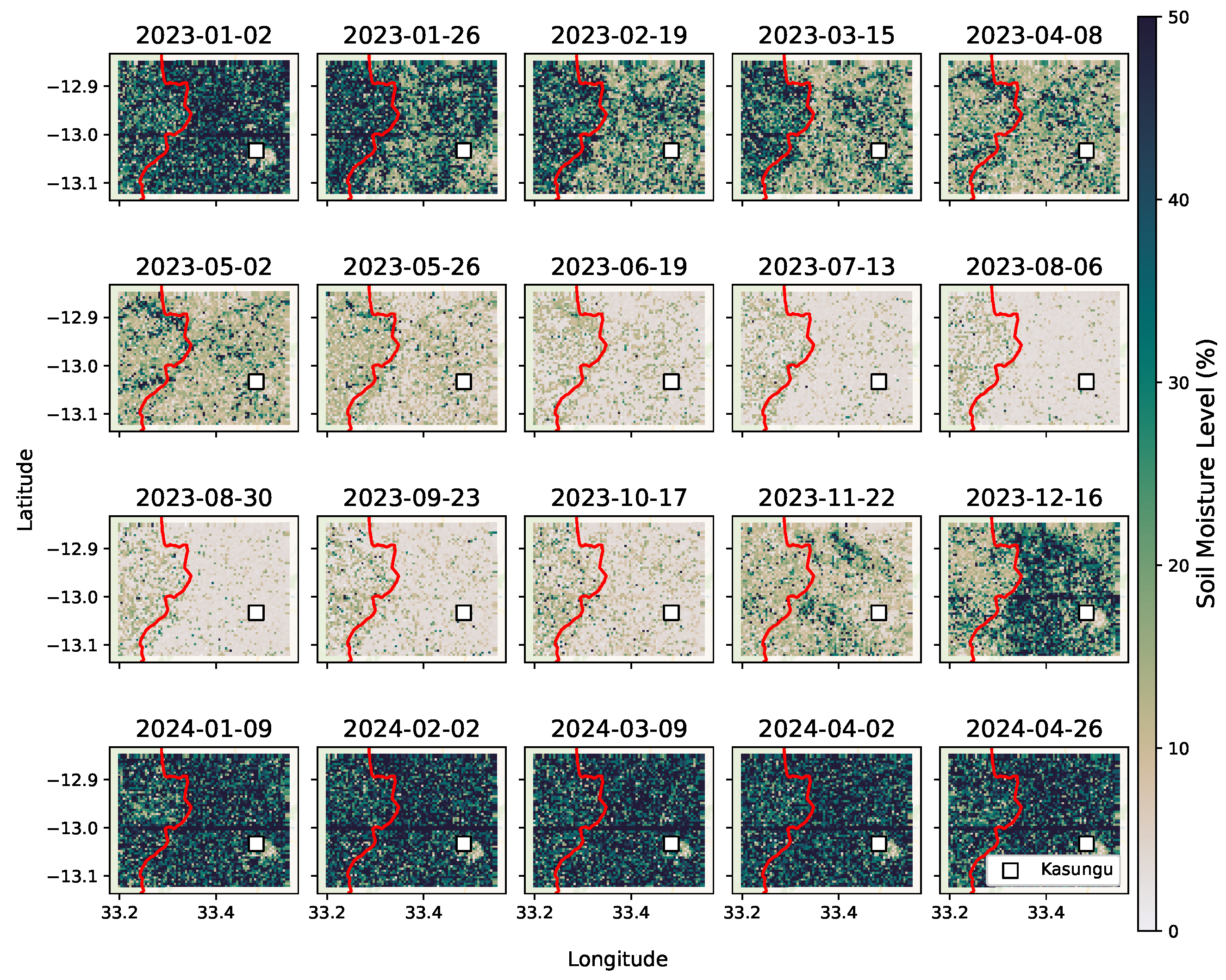
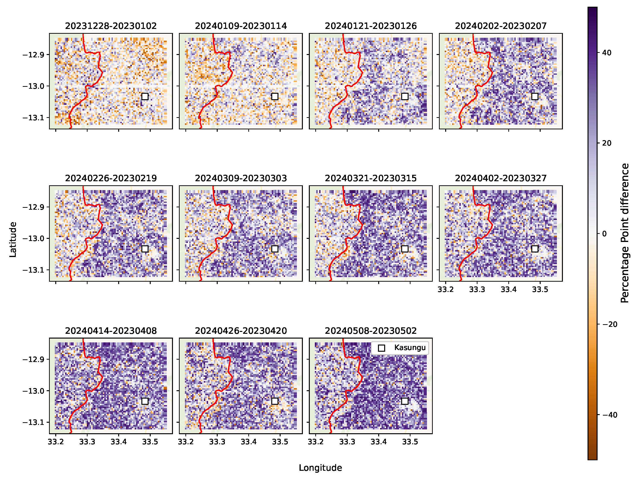
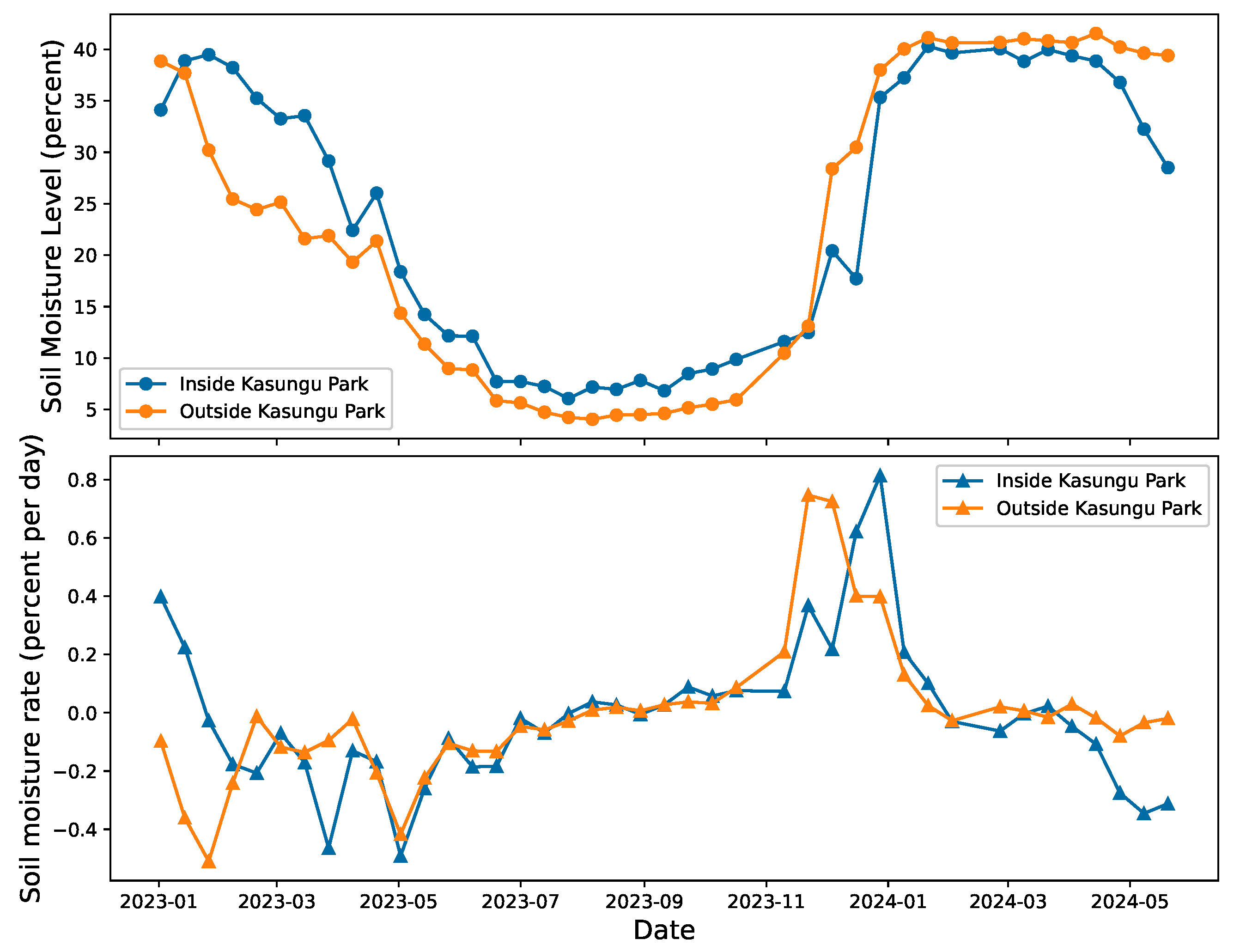
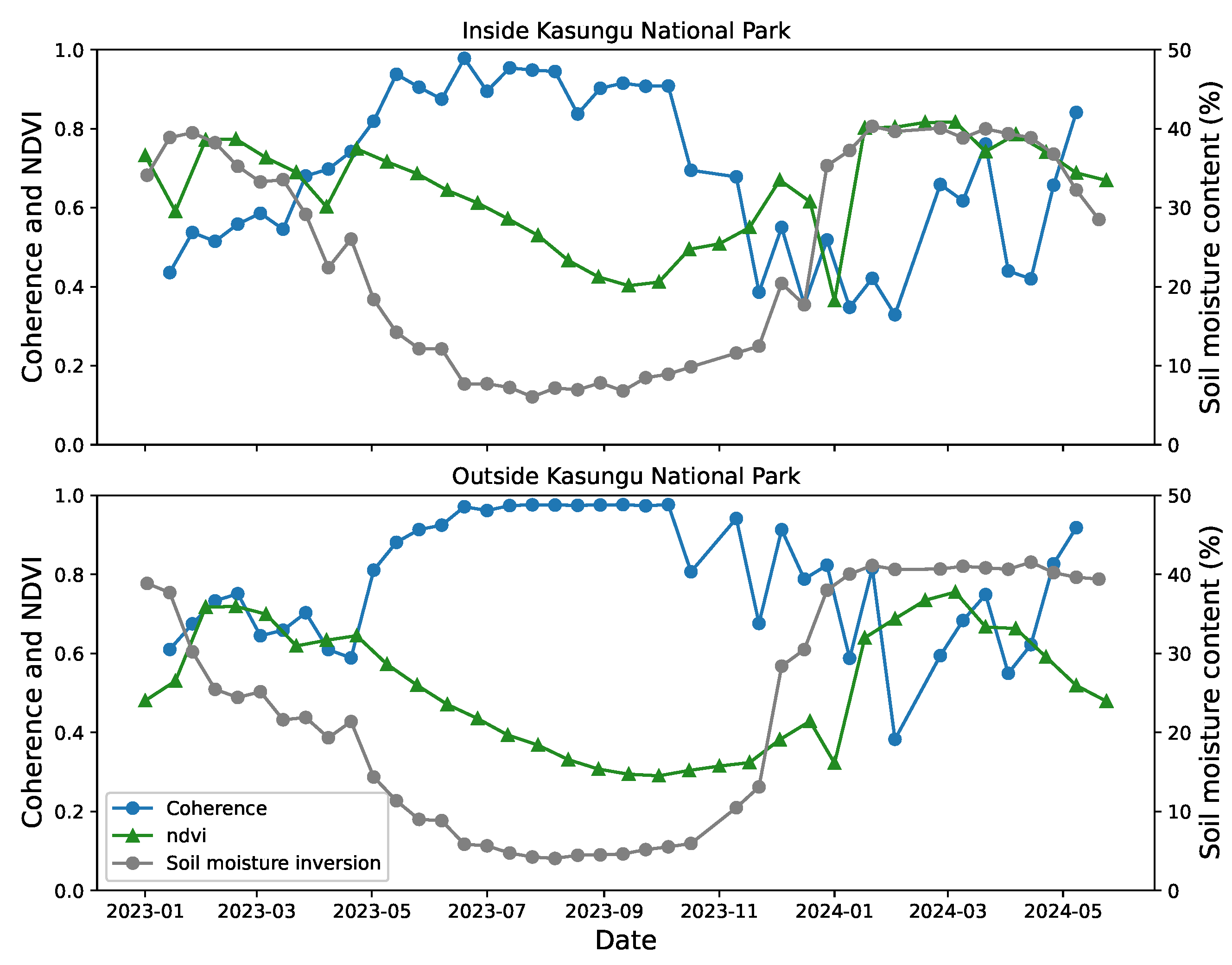
4.1. Kasungu
Comparisons Inside and Outside the National Park
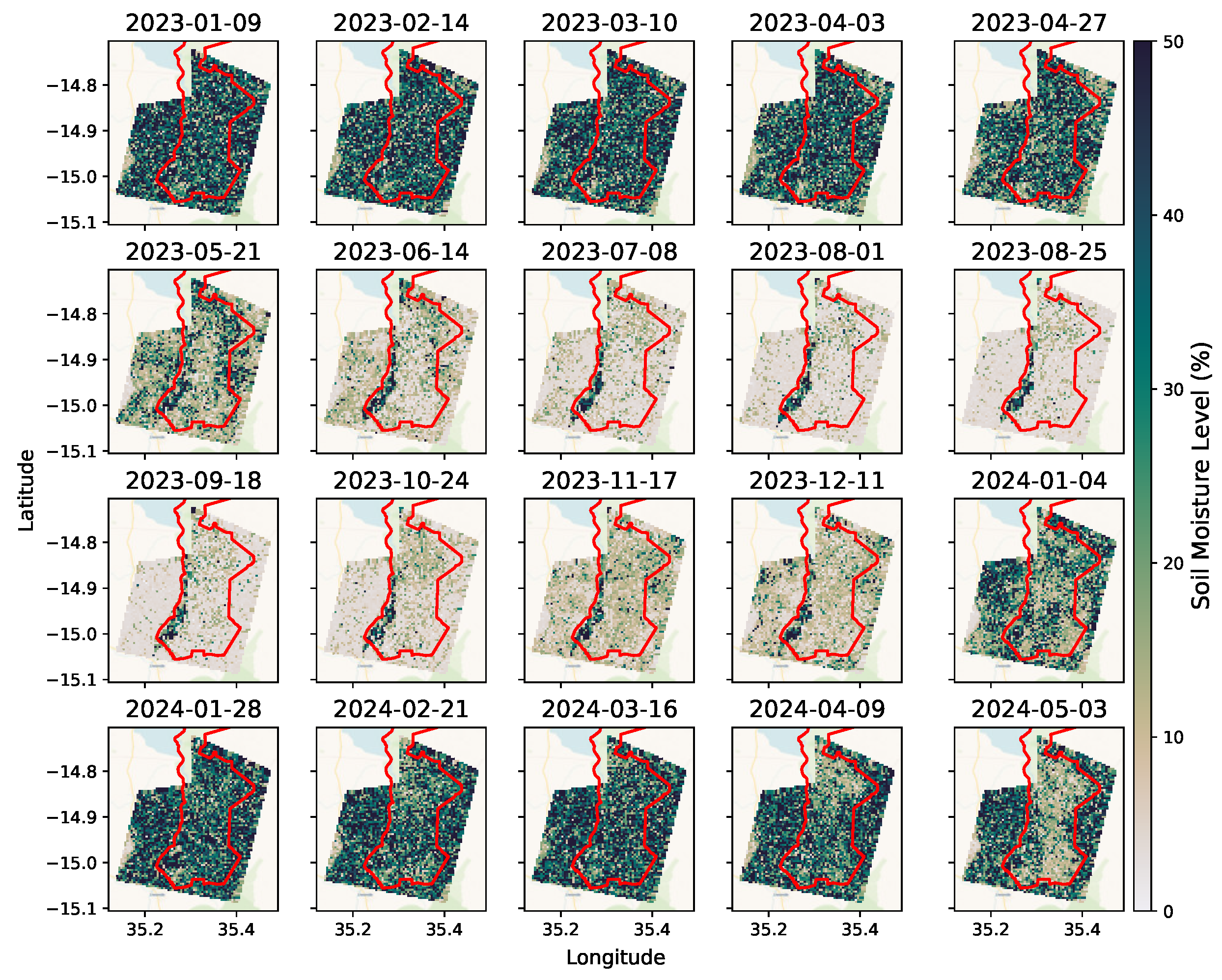
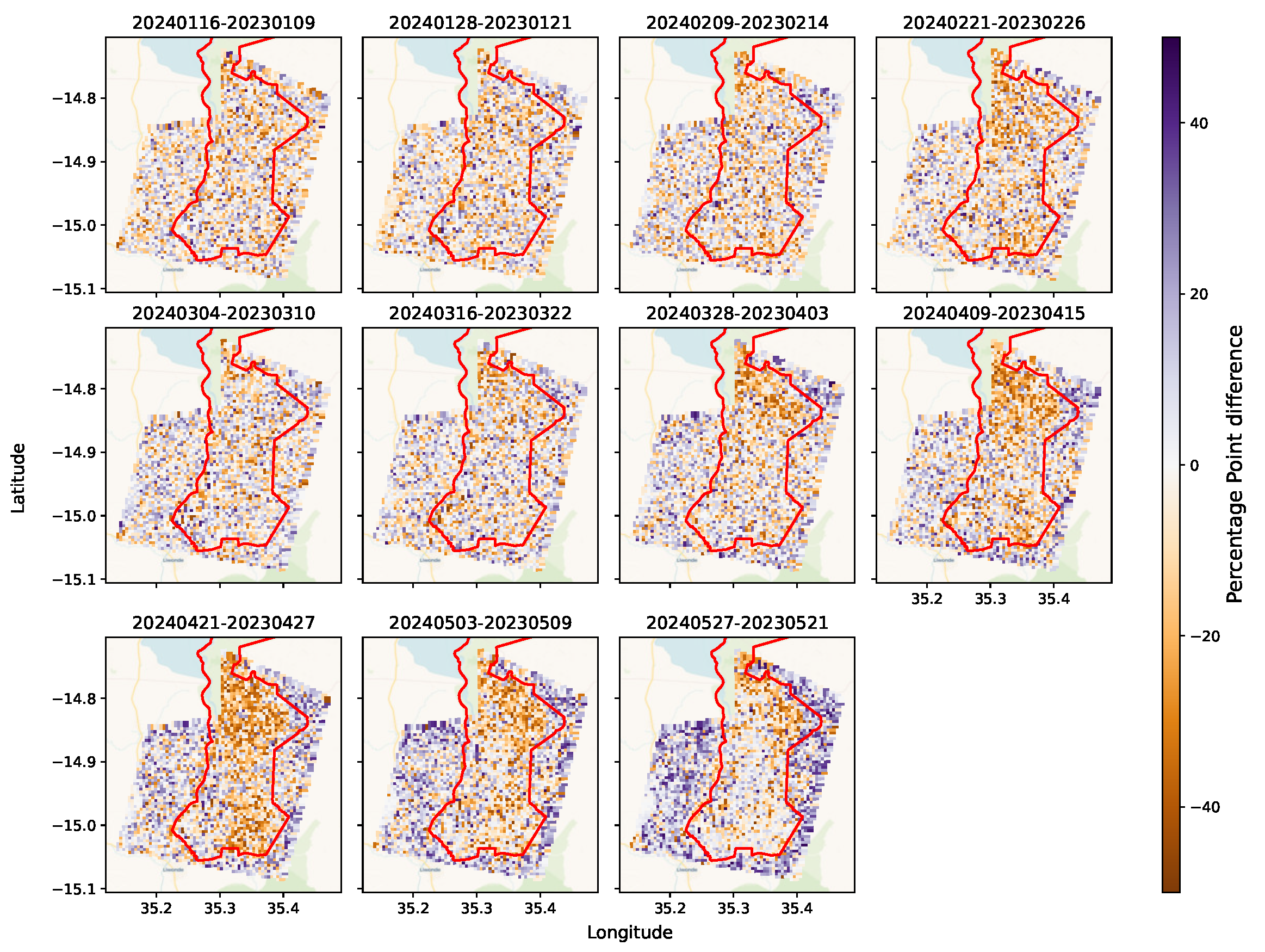
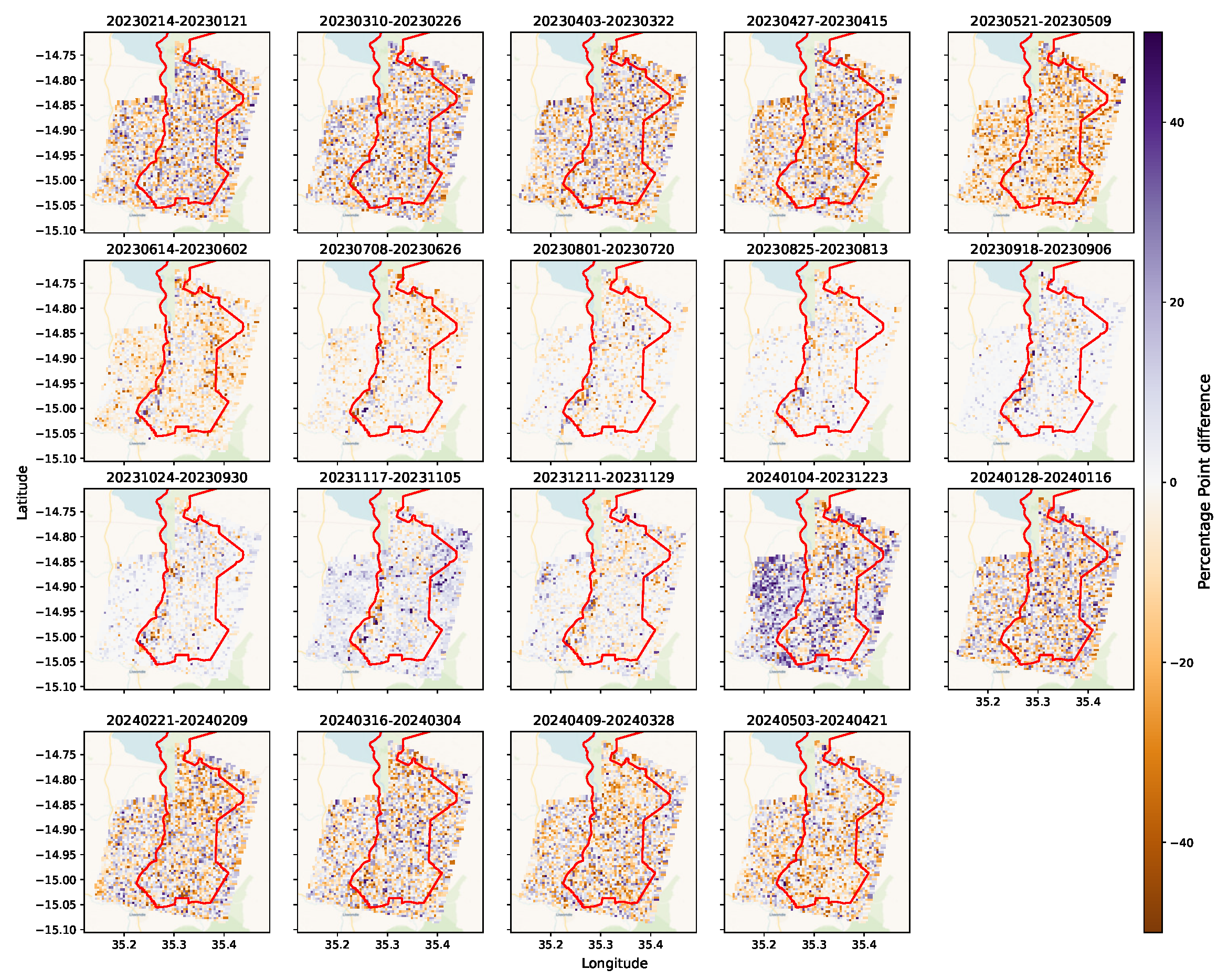
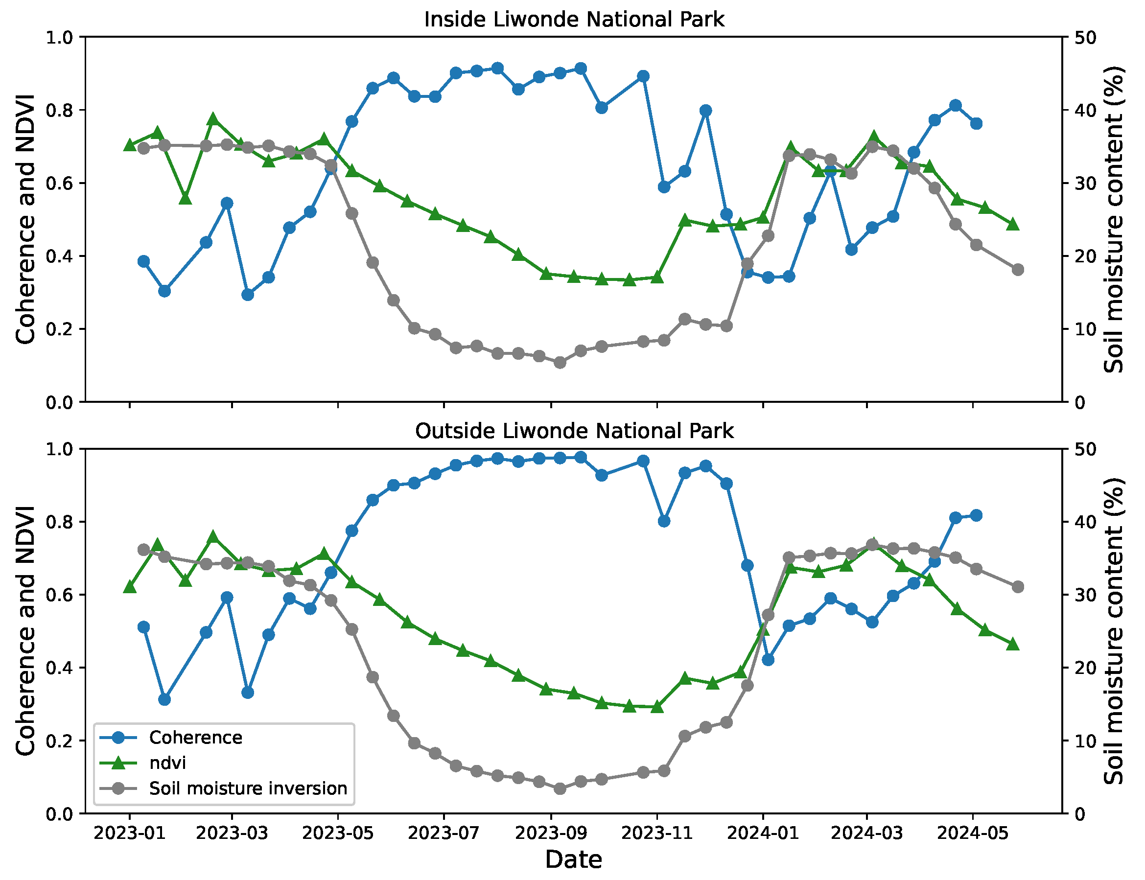
4.2. Liwonde
Comparisons Inside and Outside the National Park
5. Discussion
6. Conclusions
Supplementary Materials
Author Contributions
Funding
Data Availability Statement
Conflicts of Interest
References
- United Nations Conference on Trade and Development. The Least Developed Countries Report 2023; Technical Report; Palais des Nations: Geneva, Switzerland, 2023. [Google Scholar]
- Mucavele, F.G. True Contribution of Agriculture to Economic Growth and Poverty Reduction: Malawi, Mozambique and Zambia Synthesis Report; Technical Report; Food, Agriculture, and Natural Resources Policy Analysis Network (FANRPAN): Pretoria, South Africa, 2009. [Google Scholar]
- Tchale, H. The efficiency of smallholder agriculture in Malawi. Afr. J. Agric. Resour. Econ. 2009, 3, 101–121. [Google Scholar] [CrossRef]
- Saka, J.D.; Sibale, P.; Thomas, T.S.; Hachigonta, S.; Sibanda, L.M. Malawi—IFPRI Publications Repository—IFPRI Knowledge Collections; IFPRI: Washington, DC, USA, 2013. [Google Scholar]
- Chiang, F.; Mazdiyasni, O.; AghaKouchak, A. Evidence of anthropogenic impacts on global drought frequency, duration, and intensity. Nat. Commun. 2021, 12, 2754. [Google Scholar] [CrossRef] [PubMed]
- Ó Fionnagáin, D.; Geever, M.; O’Farrell, J.; Codyre, P.; Trearty, R.; Tessema, Y.M.; Reymondin, L.; Loboguerrero, A.M.; Spillane, C.; Golden, A. Assessing climate resilience in rice production: Measuring the impact of the Millennium Challenge Corporation’s IWRM scheme in the Senegal River Valley using remote sensing and machine learning. Environ. Res. Lett. 2024, 19, 074075. [Google Scholar] [CrossRef]
- Singh, A.; Gaurav, K.; Sonkar, G.K.; Lee, C.C. Strategies to Measure Soil Moisture Using Traditional Methods, Automated Sensors, Remote Sensing, and Machine Learning Techniques: Review, Bibliometric Analysis, Applications, Research Findings, and Future Directions. IEEE Access 2023, 11, 13605–13635. [Google Scholar] [CrossRef]
- De Zan, F.; Parizzi, A.; Prats-Iraola, P.; López-Dekker, P. A SAR Interferometric Model for Soil Moisture. IEEE Trans. Geosci. Remote Sens. 2014, 52, 418–425. [Google Scholar] [CrossRef]
- De Zan, F.; Gomba, G. Vegetation and soil moisture inversion from SAR closure phases: First experiments and results. Remote Sens. Environ. 2018, 217, 562–572. [Google Scholar] [CrossRef]
- Wig, E.; Michaelides, R.; Zebker, H. Fine-Resolution Measurement of Soil Moisture From Cumulative InSAR Closure Phase. IEEE Trans. Geosci. Remote Sens. 2024, 62, 1–15. [Google Scholar] [CrossRef]
- Karamvasis, K.; Karathanassi, V. Soil moisture estimation from Sentinel-1 interferometric observations over arid regions. Comput. Geosci. 2023, 178, 105410. [Google Scholar] [CrossRef]
- Gorelick, N.; Hancher, M.; Dixon, M.; Ilyushchenko, S.; Thau, D.; Moore, R. Google Earth Engine: Planetary-scale geospatial analysis for everyone. Remote Sens. Environ. 2017, 202, 18–27. [Google Scholar] [CrossRef]
- Muñoz Sabater, J. ERA5-Land Hourly Data from 1950 to Present. CDS 2019, 13, 4349–4383. [Google Scholar] [CrossRef]
- Hallikainen, M.T.; Ulaby, F.T.; Dobson, M.C.; El-rayes, M.A.; Wu, L.K. Microwave Dielectric Behavior of Wet Soil-Part 1: Empirical Models and Experimental Observations. IEEE Trans. Geosci. Remote Sens. 1985, GE-23, 25–34. [Google Scholar] [CrossRef]
- Poggio, L.; de Sousa, L.M.; Batjes, N.H.; Heuvelink, G.B.M.; Kempen, B.; Ribeiro, E.; Rossiter, D. SoilGrids 2.0: Producing soil information for the globe with quantified spatial uncertainty. SOIL 2021, 7, 217–240. [Google Scholar] [CrossRef]
- IUSS Working Group WRB. World Reference Base for Soil Resources. International Soil Classification System for Naming Soils and Creating Legends for Soil Maps, 4th ed.; International Union of Soil Sciences (IUSS): Rome, Italy, 2022. [Google Scholar]
- Dijkshoorn, J.A.; Leenaars, J.G.B.; Huting, J.; Kempe, B. ISRIC Report 2016/01 Soil and Terrain Database of the Republic of Malawi; Technical Report ISRIC Report 2016/01; ISRIC: Wageningen, The Netherlands, 2016. [Google Scholar]
- Fattahi, H.; Agram, P.; Simons, M. A Network-Based Enhanced Spectral Diversity Approach for TOPS Time-Series Analysis. IEEE Trans. Geosci. Remote Sens. 2017, 55, 777–786. [Google Scholar] [CrossRef]
- Villarroya-Carpio, A.; Lopez-Sanchez, J.M.; Engdahl, M.E. Sentinel-1 interferometric coherence as a vegetation index for agriculture. Remote Sens. Environ. 2022, 280, 113208. [Google Scholar] [CrossRef]
- Amherdt, S.; Di Leo, N.C.; Pereira, A.; Cornero, C.; Pacino, M.C. Assessment of interferometric coherence contribution to corn and soybean mapping with Sentinel-1 data time series. Geocarto Int. 2022, 38, 1–22. [Google Scholar] [CrossRef]
- Nasirzadehdizaji, R.; Cakir, Z.; Balik Sanli, F.; Abdikan, S.; Pepe, A.; Calò, F. Sentinel-1 interferometric coherence and backscattering analysis for crop monitoring. Comput. Electron. Agric. 2021, 185, 106118. [Google Scholar] [CrossRef]
- Bouwman, T.I.; Andersson, J.A.; Giller, K.E. Adapting yet not adopting? Conservation agriculture in Central Malawi. Agric. Ecosyst. Environ. 2021, 307, 107224. [Google Scholar] [CrossRef]


| Before Vectorisation | After Vectorisation | |
|---|---|---|
| Time | 265.948 s | 13.517 s |
Disclaimer/Publisher’s Note: The statements, opinions and data contained in all publications are solely those of the individual author(s) and contributor(s) and not of MDPI and/or the editor(s). MDPI and/or the editor(s) disclaim responsibility for any injury to people or property resulting from any ideas, methods, instructions or products referred to in the content. |
© 2025 by the authors. Licensee MDPI, Basel, Switzerland. This article is an open access article distributed under the terms and conditions of the Creative Commons Attribution (CC BY) license (https://creativecommons.org/licenses/by/4.0/).
Share and Cite
Murphy, P.C.; Codyre, P.; Geever, M.; O’Farrell, J.; Ó Fionnagáin, D.; Spillane, C.; Golden, A. Regional-Scale Analysis of Soil Moisture Content in Malawi Determined by Remote Sensing. Remote Sens. 2025, 17, 890. https://doi.org/10.3390/rs17050890
Murphy PC, Codyre P, Geever M, O’Farrell J, Ó Fionnagáin D, Spillane C, Golden A. Regional-Scale Analysis of Soil Moisture Content in Malawi Determined by Remote Sensing. Remote Sensing. 2025; 17(5):890. https://doi.org/10.3390/rs17050890
Chicago/Turabian StyleMurphy, Pearse C., Patricia Codyre, Michael Geever, Jemima O’Farrell, Dúalta Ó Fionnagáin, Charles Spillane, and Aaron Golden. 2025. "Regional-Scale Analysis of Soil Moisture Content in Malawi Determined by Remote Sensing" Remote Sensing 17, no. 5: 890. https://doi.org/10.3390/rs17050890
APA StyleMurphy, P. C., Codyre, P., Geever, M., O’Farrell, J., Ó Fionnagáin, D., Spillane, C., & Golden, A. (2025). Regional-Scale Analysis of Soil Moisture Content in Malawi Determined by Remote Sensing. Remote Sensing, 17(5), 890. https://doi.org/10.3390/rs17050890