
Accuracy Assessment of Four Land Cover Datasets at Urban, Rural and Metropolitan Area Level


Abstract
1. Introduction
- To analyze the overall accuracy of four datasets: CLC Backbone, HRL–Imperviousness, Dynamic World and Esri Land Cover.
- To assess the performance of these datasets in representing built areas at metropolitan, urban and rural levels.
- To validate the accuracy results in four metropolitan areas.
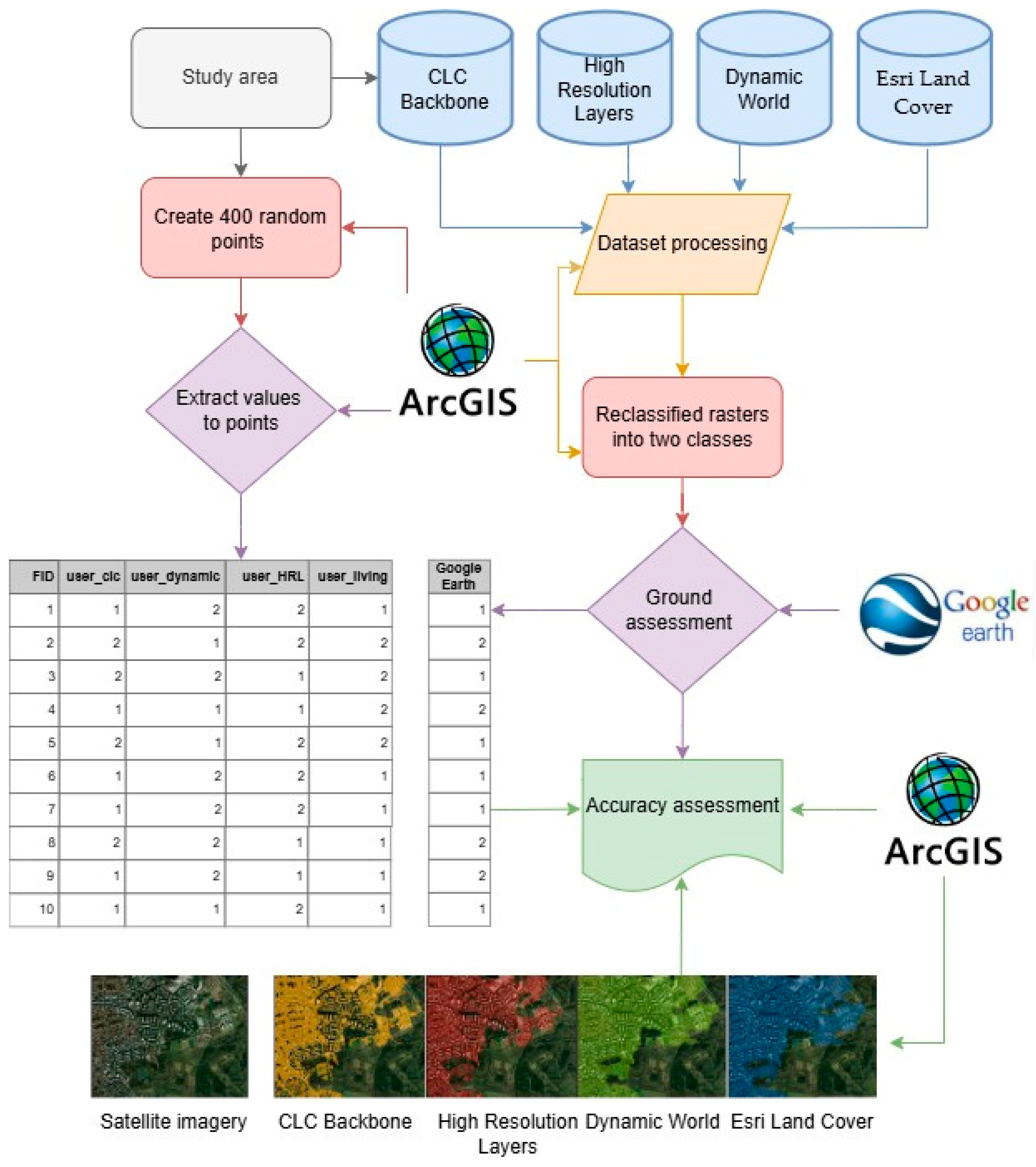
2. Materials and Methods
2.1. Study Area
2.2. Data Source
2.3. Data Processing
2.4. Accuracy Assessment
3. Results
3.1. General Observations
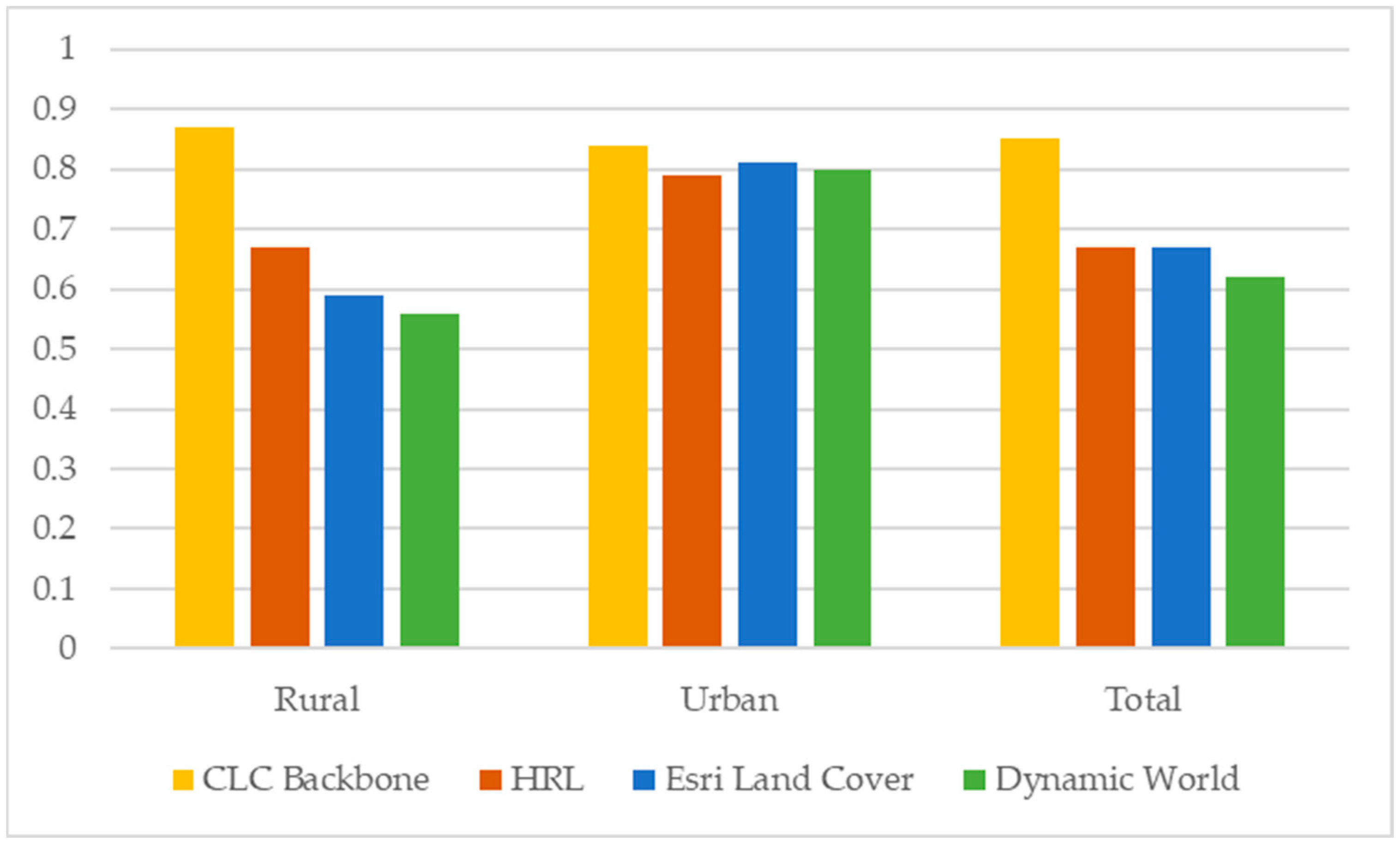
3.2. Accuracy Results for the Entire Urban Surface of the 12 MAs
3.3. Accuracy Results for Four MAs
4. Discussion
4.1. Explaining the Differences Between the Analyzed Datasets
4.2. Limitations and Future Research Directions
5. Conclusions
Author Contributions
Funding
Data Availability Statement
Acknowledgments
Conflicts of Interest
References
- Olofsson, P.; Foody, G.M.; Stehman, S.V.; Woodcock, C.E. Making better use of accuracy data in land change studies: Estimating accuracy and area and quantifying uncertainty using stratified estimation. Remote Sens. Environ. 2013, 129, 122–131. [Google Scholar] [CrossRef]
- Pesaresi, M.; Corbane, C.; Julea, A.; Florczyk, A.J.; Syrris, V.; Soille, P. Assessment of the added-value of Sentinel-2 for detecting built-up areas. Remote Sens. 2016, 8, 299. [Google Scholar] [CrossRef]
- Karra, K.; Kontgis, C.; Statman-Weil, Z.; Mazzariello, J.C.; Mathis, M.; Brumby, S.P. Global land use/land cover with Sentinel 2 and deep learning. In Proceedings of the 2021 IEEE International Geoscience and Remote Sensing Symposium IGARSS, Brussels, Belgium, 11–16 July 2021; IEEE: Piscataway, NJ, USA, 2021; pp. 4704–4707. [Google Scholar]
- Fonte, C.C.; Duarte, D.; Jesus, I.; Costa, H.; Benevides, P.; Moreira, F.; Caetano, M. Accuracy Assessment and Comparison of National, European and Global Land Use Land Cover Maps at the National Scale—Case Study: Portugal. Remote Sens. 2024, 16, 1504. [Google Scholar] [CrossRef]
- Szantoi, Z.; Geller, G.N.; Tsendbazar, N.E.; See, L.; Griffiths, P.; Fritz, S.; Gong, P.; Herold, M.; Mora, B.; Obregón, A. Addressing the need for improved land cover map products for policy support. Environ. Sci. Policy 2020, 112, 28–35. [Google Scholar] [CrossRef]
- Rozenstein, O.; Karnieli, A. Comparison of methods for land-use classification incorporating remote sensing and GIS inputs. Appl. Geogr. 2011, 31, 533–544. [Google Scholar] [CrossRef]
- Zhang, Q.; Li, B.; Thau, D.; Moore, R. Building a better urban picture: Combining day and night remote sensing imagery. Remote Sens. 2015, 7, 11887–11913. [Google Scholar] [CrossRef]
- Dolean, B.E.; Bilașco, Ș.; Petrea, D.; Moldovan, C.; Vescan, I.; Roșca, S.; Fodorean, I. Evaluation of the built-up area dynamics in the first ring of Cluj-Napoca metropolitan area, Romania by semi-automatic GIS analysis of Landsat satellite images. Appl. Sci. 2020, 10, 7722. [Google Scholar] [CrossRef]
- Liu, H.; Gong, P.; Wang, J.; Wang, X.; Ning, G.; Xu, B. Production of global daily seamless data cubes and quantification of global land cover change from 1985 to 2020-iMap World 1.0. Remote Sens. Environ. 2021, 258, 112364. [Google Scholar] [CrossRef]
- Brown, C.F.; Brumby, S.P.; Guzder-Williams, B.; Birch, T.; Hyde, S.B.; Mazzariello, J.; Czerwinski, W.; Pasquarella, V.J.; Haertel, R.; Ilyushchenko, S.; et al. Dynamic World, Near real-time global 10 m land use land cover mapping. Sci. Data 2022, 9, 251. [Google Scholar] [CrossRef]
- ESRI. Sentinel-2 10-Meter Land Use/Land Cover. Available online: https://livingatlas.arcgis.com/landcover/ (accessed on 12 July 2024).
- Patel, N.N.; Angiuli, E.; Gamba, P.; Gaughan, A.; Lisini, G.; Stevens, F.R.; Tatem, A.J.; Trianni, G. Multitemporal settlement and population mapping from Landsat using Google Earth Engine. Int. J. Appl. Earth Obs. Geoinf. 2015, 35, 199–208. [Google Scholar] [CrossRef]
- Gorelick, N.; Hancher, M.; Dixon, M.; Ilyushchenko, S.; Thau, D.; Moore, R. Google Earth Engine: Planetary-scale geospatial analysis for everyone. Remote Sens. Environ. 2017, 202, 18–27. [Google Scholar] [CrossRef]
- Zanaga, D.; Van De Kerchove, R.; De Keersmaecker, W.; Souverijns, N.; Brockmann, C.; Quast, R.; Wevers, J.; Grosu, A.; Paccini, A.; Vergnaud, S.; et al. ESA WorldCover 10 m 2020 V100. OpenAIRE 2021. Available online: https://www.openaire.eu/ (accessed on 22 September 2024).
- Zheng, K.; He, G.; Yin, R.; Wang, G.; Long, T. A Comparison of Seven Medium Resolution Impervious Surface Products on the Qinghai–Tibet Plateau, China from a User’s Perspective. Remote Sens. 2023, 15, 2366. [Google Scholar] [CrossRef]
- Pérez-Hoyos, A.; García-Haro, F.J.; San-Miguel-Ayanz, J. Conventional and fuzzy comparisons of large scale land cover products: Application to CORINE, GLC2000, MODIS and GlobCover in Europe. ISPRS J. Photogramm. Remote Sens. 2012, 74, 185–201. [Google Scholar] [CrossRef]
- Hua, T.; Zhao, W.; Liu, Y.; Wang, S.; Yang, S. Spatial consistency assessments for global land-cover datasets: A comparison among GLC2000, CCI LC, MCD12, GLOBCOVER and GLCNMO. Remote Sens. 2018, 10, 1846. [Google Scholar] [CrossRef]
- Pietroniro, A.; Soulis, E.D. Comparison of global land-cover databases in the Mackenzie basin, Canada. In Remote Sensing and Hydrology 2000; IAHS: Wallingford, UK, 2001; pp. 552–557. [Google Scholar]
- Caetano, M.; Araújo, A. Comparing land cover products CLC2000 and MOD12Q1 for Portugal. In Global Developments in Environmental Earth Observation from Space; IOS Press: Amsterdam, The Netherlands, 2006; pp. 469–477. [Google Scholar]
- Tchuenté, A.T.K.; Roujean, J.L.; De Jong, S.M. Comparison and relative quality assessment of the GLC2000, GLOBCOVER, MODIS and ECOCLIMAP land cover data sets at the African continental scale. Int. J. Appl. Earth Obs. Geoinf. 2011, 13, 207–219. [Google Scholar] [CrossRef]
- Klotz, M.; Kemper, T.; Geiß, C.; Esch, T.; Taubenböck, H. How good is the map? A multi-scale cross-comparison framework for global settlement layers: Evidence from Central Europe. Remote Sens. Environ. 2016, 178, 191–212. [Google Scholar] [CrossRef]
- Diaz-Pacheco, J.; Gutiérrez, J. Exploring the limitations of CORINE Land Cover for monitoring urban land-use dynamics in metropolitan areas. J. Land Use Sci. 2013, 9, 243–259. [Google Scholar] [CrossRef]
- Kaim, D.; Ziółkowska, E.; Grădinaru, S.R.; Pazúr, R. Assessing the suitability of urban-oriented land cover products for mapping rural settlements. Int. J. Geogr. Inf. Sci. 2022, 36, 2412–2426. [Google Scholar] [CrossRef]
- Venter, Z.S.; Barton, D.N.; Chakraborty, T.; Simensen, T.; Singh, G. Global 10 m land use land cover datasets: A comparison of Dynamic World, World Cover and ESRI land cover. Remote Sens. 2022, 14, 4101. [Google Scholar] [CrossRef]
- Bie, Q.; Luo, J.; Lu, G. Accuracy Performance of Three 10-m Global Land Cover Products Around 2020 in an Arid Region of Northwestern China. IEEE Access 2023, 11, 133215–133228. [Google Scholar] [CrossRef]
- Wang, Z.; Mountrakis, G. Accuracy Assessment of Eleven Medium Resolution Global and Regional Land Cover Land Use Products: A Case Study over the Conterminous United States. Remote Sens. 2023, 15, 3186. [Google Scholar] [CrossRef]
- Xu, P.; Tsendbazar, N.E.; Herold, M.; de Bruin, S.; Koopmans, M.; Birch, T.; Carter, S.; Fritz, S.; Lesiv, M.; Mazur, E.; et al. Comparative validation of recent 10 m-resolution global land cover maps. Remote Sens. Environ. 2024, 311, 114316. [Google Scholar] [CrossRef]
- Kang, J.; Yang, X.; Wang, Z.; Cheng, H.; Wang, J.; Tang, H.; Bai, Z. Comparison of three ten meter land cover products in a Drought region: A case study in Northwestern China. Land 2022, 11, 427. [Google Scholar] [CrossRef]
- Olofsson, P.; Foody, G.M.; Herold, M.; Stehman, S.V.; Woodcock, C.E.; Wulder, M.A. Good practices for estimating area and assessing accuracy of land change. Remote Sens. Environ. 2014, 148, 42–57. [Google Scholar] [CrossRef]
- Stehman, S.V.; Foody, G.M. Key issues in rigorous accuracy assessment of land cover products. Remote Sens. Environ. 2019, 231, 111199. [Google Scholar] [CrossRef]
- Phiri, D.; Simwanda, M.; Salekin, S.; Nyirenda, V.R.; Murayama, Y.; Ranagalage, M. Sentinel-2 data for land cover/use mapping: A review. Remote Sens. 2020, 12, 2291. [Google Scholar] [CrossRef]
- Chaaban, F.; El Khattabi, J.; Darwishe, H. Accuracy assessment of ESA WorldCover 2020 and ESRI 2020 land cover maps for a Region in Syria. J. Geovisualization Spat. Anal. 2022, 6, 31. [Google Scholar] [CrossRef]
- Benedek, J.; Ursu, C.-D.; Varvari, Ş. Growth pole policy’s induced development and spatial inequalities in the metropolitan areas of Romania-a critical assessment. Tér és Társadalom. 2022, 36, 47–67. [Google Scholar] [CrossRef]
- Ursu, C.D.; Benedek, J. Evolution of Built Surfaces Based on Copernicus High Resolution Layers. The Case of Growth Poles-Based Metropolitan Areas, Romania. J. Settl. Spat. Plan. 2022, 13, 45–59. [Google Scholar]
- Holobâcă, I.H.; Benedek, J.; Ursu, C.D.; Alexe, M.; Temerdek-Ivan, K. Ratio of Land Consumption Rate to Population Growth Rate in the Major Metropolitan Areas of Romania. Remote Sens. 2022, 14, 6016. [Google Scholar] [CrossRef]
- Stoica, I.V.; Vîrghileanu, M.; Zamfir, D.; Mihai, B.A.; Săvulescu, I. Comparative assessment of the built-up area expansion based on Corine land cover and landsat datasets: A case study of a post-socialist city. Remote Sens. 2020, 12, 2137. [Google Scholar] [CrossRef]
- National Institute of Statistics. 2021 Census. 2021. Available online: https://www.recensamantromania.ro/rezultate-rpl-2021/rezultate-definitive/ (accessed on 5 May 2024).
- Ionescu-Heroiu, M.; Cristea, M.; China, A.-M.; Butacu, B.-C.; Dolean, B.E.; Vinţan, A.D.; Frant, O.; Mihăilescu, G.M.; Moldovan, S.C.; Sfârlea, E.V.; et al. Romania Catching-Up Regions: Metropolitan Romania (English); World Bank Group: Washington, DC, USA, 2019; Available online: https://documents.worldbank.org/en/publication/documents-reports/documentdetail/255131580296079611/romania-catching-up-regions-metropolitan-romania (accessed on 12 January 2025).
- Kriss, P.; Ivanov, I.; Taralunga, N.; Racoviceanu, S.C.; Stadler, R.-L.; Ghintuiala, D.-L.; Ionescu-Heroiu, M.; Silimela, Y.T.; Vinţan, A.D.; Moldoveanu, G.A.; et al. Romania Catching-Up Regions: Interjurisdictional Cooperation Models (English); World Bank Group: Washington, DC, USA, 2021; Available online: http://documents.worldbank.org/curated/en/193121580281956431/Romania-Catching-Up-Regions-Interjurisdictional-Cooperation-Models (accessed on 12 January 2025).
- Lu, D.; Hetrick, S.; Moran, E. Land cover classification in a complex urban-rural landscape with QuickBird imagery. Photogramm. Eng. Remote Sens. 2010, 76, 1159–1168. [Google Scholar] [CrossRef] [PubMed]
- Wei, X.; Zhang, W.; Zhang, Z.; Huang, H.; Meng, L. Urban land use land cover classification based on GF-6 satellite imagery and multi-feature optimization. Geocarto Int. 2023, 38, 2236579. [Google Scholar] [CrossRef]
- Uhl, J.H.; Leyk, S. Towards localized accuracy assessment of remote-sensing derived built-up land layers across the rural-urban continuum. arXiv 2024, arXiv:2403.00166. [Google Scholar]
- Paris, C.; Martinez-Sanchez, L.; van der Velde, M.; Sharma, S.; Sedona, R.; Cavallaro, G. Accuracy assessment of land-use-land-cover maps: The semantic gap between in situ and satellite data. In Image and Signal Processing for Remote Sensing XXIX; SPIE: Bellingham, WA, USA, 2023; Volume 12733, pp. 187–200. [Google Scholar]
- Ahmed, R.; Zafor, M.A.; Trachte, K. Land-use and land-cover changes in Cottbus city and Spree-Neisse district, Germany, in the last two decades: A study using remote sensing data and Google Earth Engine. Remote Sens. 2024, 16, 2773. [Google Scholar] [CrossRef]
- Panek-Chwastyk, E.; Dąbrowska-Zielińska, K.; Markowska, A.; Kluczek, M.; Pieniążek, M. Advanced utilization of satellite and governmental data for determining the coverage and condition of green areas in Poland: An experimental statistics supporting the Statistics Poland. Int. J. Appl. Earth Obs. Geoinf. 2024, 130, 103883. [Google Scholar] [CrossRef]
- Bathe, K.D.; Patil, N.S. Assessment of land use-land cover dynamics and its future projection through Google Earth Engine, machine learning and QGIS-MOLUSCE: A case study in Jagatsinghpur district, Odisha, India. J. Earth Syst. Sci. 2024, 133, 111. [Google Scholar] [CrossRef]
- Sannier, C.; Ivits, E.; Maucha, G.; Maes, J.; Dijkstra, L. Harmonized Pan-European Time Series for Monitoring Soil Sealing. Land 2024, 13, 1087. [Google Scholar] [CrossRef]
- European Environment Agency. Imperviousness Density 2018 (raster 10 m and 100 m), Europe, 3-Yearly. 2018. Available online: https://land.copernicus.eu/en/products/high-resolution-layer-imperviousness/imperviousness-density-2018 (accessed on 28 June 2024).
- European Environment Agency. CLC+ Backbone. 2024. Available online: https://land.copernicus.eu/en/products/clc-backbone (accessed on 10 July 2024).
- Dynamic World App. Available online: https://dynamicworld.app/ (accessed on 12 July 2024).
- European Environment Agency. CLC+ Backbone Product Specification and User Manual, Issue 3. 2022. Available online: https://land.copernicus.eu/en/technical-library/clc-backbone-product-user-manual/@@download/file (accessed on 9 June 2024).
- Waterman, R. Global Land Cover Revealed. 2023. Available online: https://www.esri.com/arcgis-blog/products/arcgis-living-atlas/imagery/global-land-cover-revealed/ (accessed on 28 July 2024).
- Rwanga, S.; Ndambuki, J. Accuracy Assessment of Land Use/Land Cover Classification Using Remote Sensing and GIS. Int. J. Geosci. 2017, 8, 611–622. [Google Scholar] [CrossRef]
- Landis, J.R.; Koch, G.G. A One-Way Components of Variance Model for Categorical Data. Biometrics 1977, 33, 671–679. [Google Scholar] [CrossRef]
- The United Nations. The 17 Goals. Available online: https://sdgs.un.org/goals (accessed on 12 July 2024).


| Dataset | Resolution for Each Year | Level of Updating | Provider |
|---|---|---|---|
| High Resolution Layers–Imperviousness | 20, 100 m (2006, 2009, 2012, 2015) 10, 100 m–2018 | 3-yearly | European Environment Agency [48] |
| CLC Backbone | 10 m (2018, 2021) | 3-yearly | European Environment Agency [49] |
| Dynamic World | 10 m (2015–up to present) Near real-time data | Yearly | Google and the World Resources Institute [50] |
| Esri Land Cover | 10 m (2017–2023) | Yearly | ESRI [11] |
| Kappa Statistics | Strength of Agreement |
|---|---|
| <0.00 | Poor |
| 0.00–0.20 | Slight |
| 0.21–0.40 | Fair |
| 0.41–0.60 | Moderate |
| 0.61–0.80 | Substantial |
| 0.81–1.00 | Almost perfect |
| CLC Backbone | Built_Up | Other | Total |
|---|---|---|---|
| Built_up | 139 | 8 | 147 |
| Other | 54 | 199 | 253 |
| Total | 193 | 207 | 400 |
| 12 MAs | Dynamic World | CLC Backbone | Esri Land Cover | HRL |
|---|---|---|---|---|
| Overall accuracy | 0.62 | 0.85 | 0.67 | 0.67 |
| Kappa | 0.49 | 0.5 | 0.49 | 0.5 |
| User accuracy | 0.57 | 0.95 | 0.6 | 0.68 |
| Urban | Dynamic World | CLC Backbone | Esri Land Cover | HRL |
|---|---|---|---|---|
| Overall accuracy | 0.8 | 0.84 | 0.81 | 0.79 |
| Kappa | 0.51 | 0.5 | 0.51 | 0.5 |
| User accuracy | 0.75 | 0.9 | 0.74 | 0.78 |
| Rural | Dynamic World | CLC Backbone | Esri Land Cover | HRL |
|---|---|---|---|---|
| Overall accuracy | 0.56 | 0.87 | 0.59 | 0.67 |
| Kappa | 0.47 | 0.63 | 0.43 | 0.59 |
| User accuracy | 0.36 | 0.84 | 0.4 | 0.4 |
Disclaimer/Publisher’s Note: The statements, opinions and data contained in all publications are solely those of the individual author(s) and contributor(s) and not of MDPI and/or the editor(s). MDPI and/or the editor(s) disclaim responsibility for any injury to people or property resulting from any ideas, methods, instructions or products referred to in the content. |
© 2025 by the authors. Licensee MDPI, Basel, Switzerland. This article is an open access article distributed under the terms and conditions of the Creative Commons Attribution (CC BY) license (https://creativecommons.org/licenses/by/4.0/).
Share and Cite
Ursu, C.-D.; Benedek, J.; Temerdek-Ivan, K. Accuracy Assessment of Four Land Cover Datasets at Urban, Rural and Metropolitan Area Level. Remote Sens. 2025, 17, 756. https://doi.org/10.3390/rs17050756
Ursu C-D, Benedek J, Temerdek-Ivan K. Accuracy Assessment of Four Land Cover Datasets at Urban, Rural and Metropolitan Area Level. Remote Sensing. 2025; 17(5):756. https://doi.org/10.3390/rs17050756
Chicago/Turabian StyleUrsu, Cosmina-Daniela, Jozsef Benedek, and Kinga Temerdek-Ivan. 2025. "Accuracy Assessment of Four Land Cover Datasets at Urban, Rural and Metropolitan Area Level" Remote Sensing 17, no. 5: 756. https://doi.org/10.3390/rs17050756
APA StyleUrsu, C.-D., Benedek, J., & Temerdek-Ivan, K. (2025). Accuracy Assessment of Four Land Cover Datasets at Urban, Rural and Metropolitan Area Level. Remote Sensing, 17(5), 756. https://doi.org/10.3390/rs17050756