
Study on the Extraction of Topsoil-Loss Areas of Cultivated Land Based on Multi-Source Remote Sensing Data

Abstract
1. Introduction
2. Materials and Methods
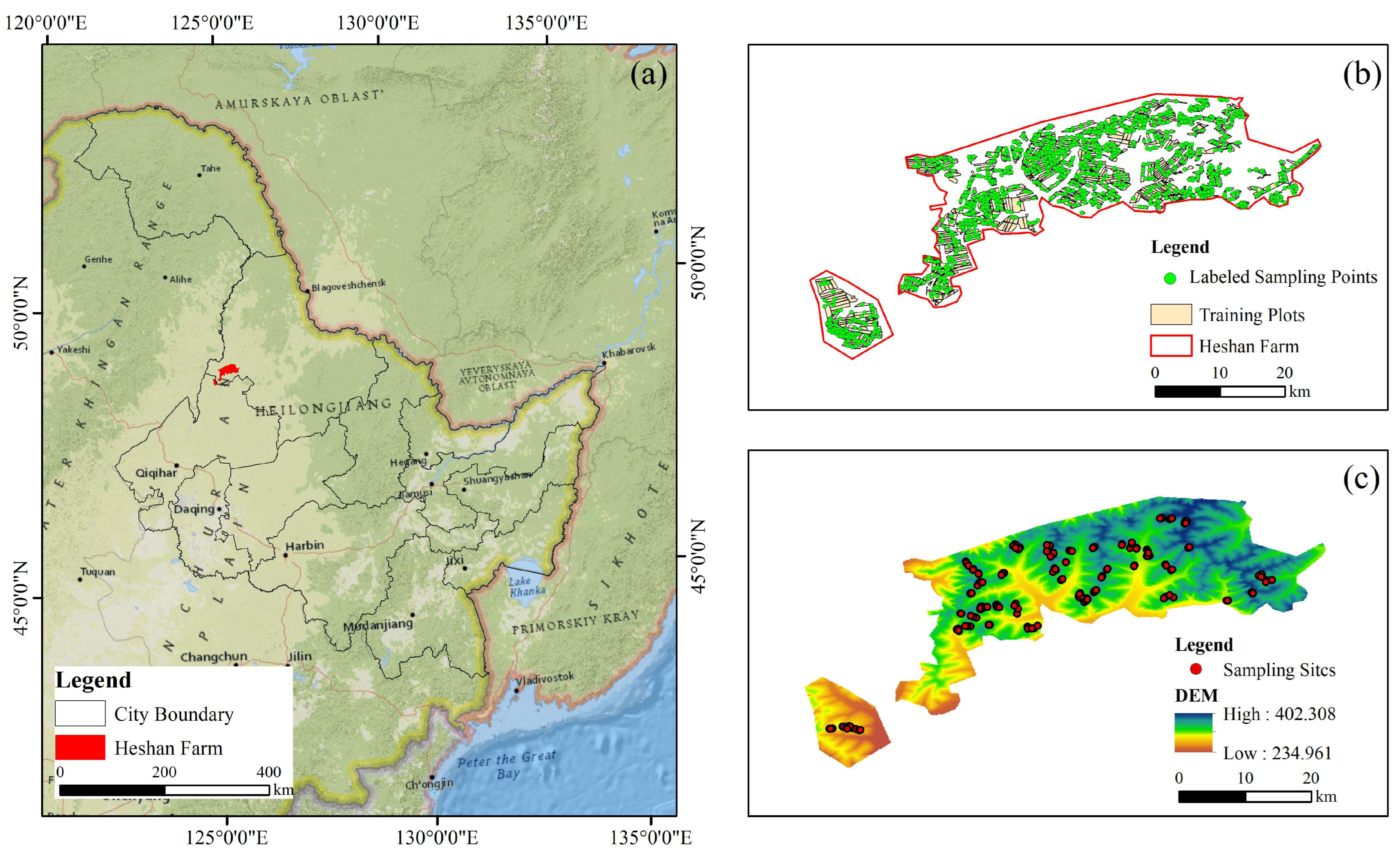
2.1. Study Area
2.2. Data Acquisition and Processing
2.2.1. Remote Sensing Image Data Acquisition and Pre-Processing
2.2.2. Sample Labeling
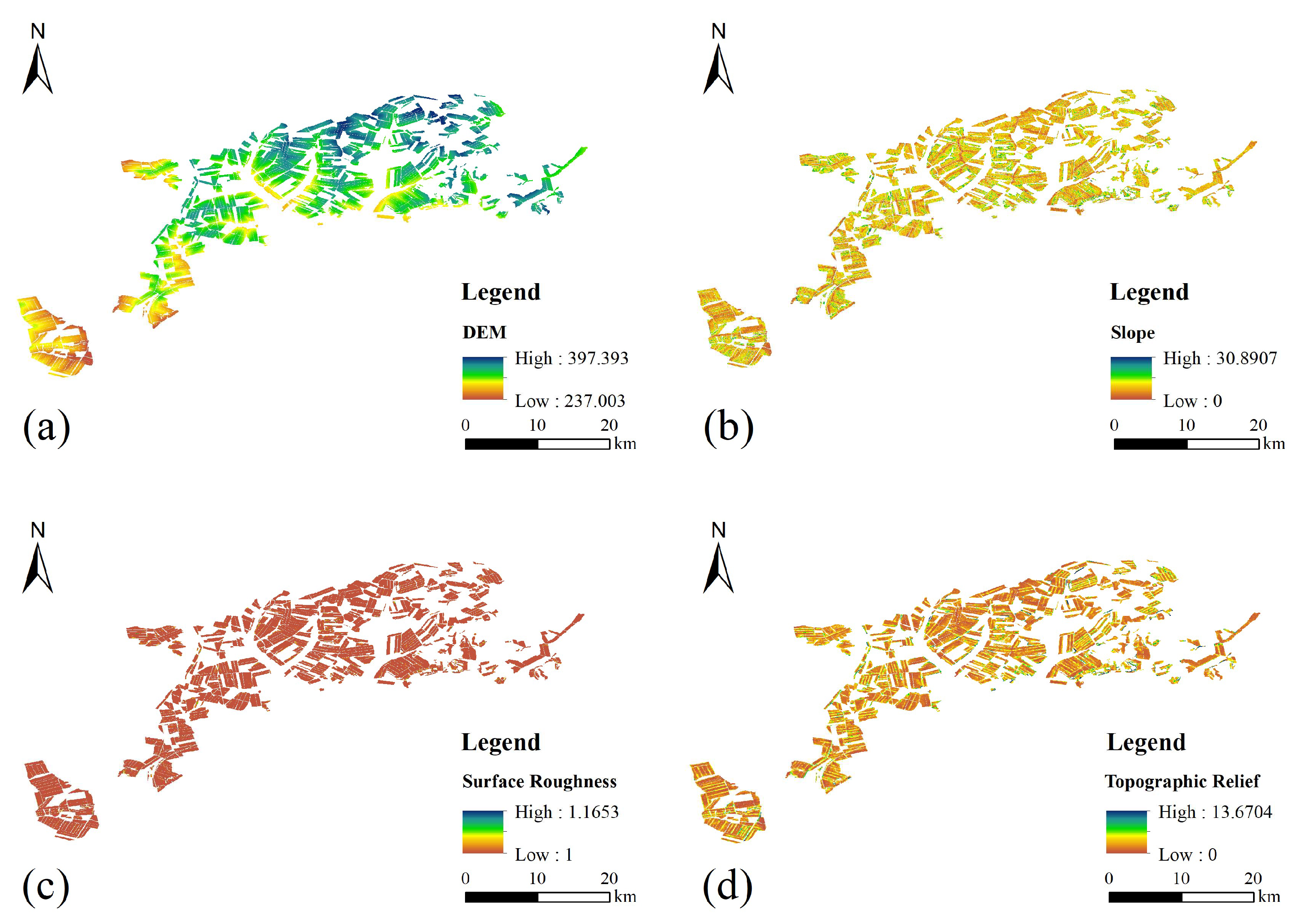
2.2.3. Topographic Data Acquisition and Processing
2.2.4. Collection and Processing of Soil Sample Data
2.3. Spectral Feature Index Construction
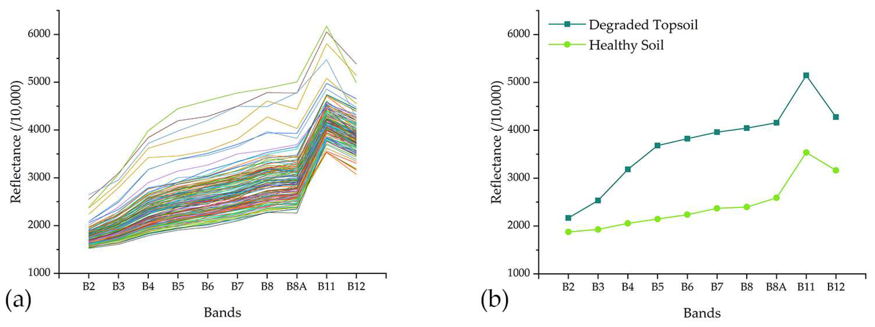
2.3.1. Spectral Analysis
2.3.2. Spectral Index Extraction
2.4. Models and Optimization
2.4.1. Random Forest
2.4.2. Support Vector Machines
2.4.3. Particle Swarm Optimization
2.5. Classification Results and Accuracy Assessment
2.6. Technological Processes
- (1)
- Data Acquisition and Preprocessing: Collect Sentinel-2 satellite imagery and DEM data. Preprocess the collected data to obtain band data and terrain data for the study area. Combine field survey data and visual interpretation to create a labeled dataset for model training. Analyze the reflectance characteristics of ground objects and extract key spectral indices;
- (2)
- Extraction Scheme Design and Model Construction: Utilize multi-source remote sensing data to design four different land cover extraction schemes. Develop remote sensing monitoring models based on SVM and RF algorithms. Apply the PSO algorithm to optimize the models and enhance their performance;
- (3)
- Accuracy Assessment and Result Analysis: Evaluate the impact of different features on model performance and analyze the importance of features. Compare the extraction effects and accuracy of the four schemes and different models to determine the optimal extraction scheme and model. Use the extraction results from the optimal model to explore the spatial distribution pattern of topsoil degradation areas and analyze its potential impact on crop growth.
3. Results
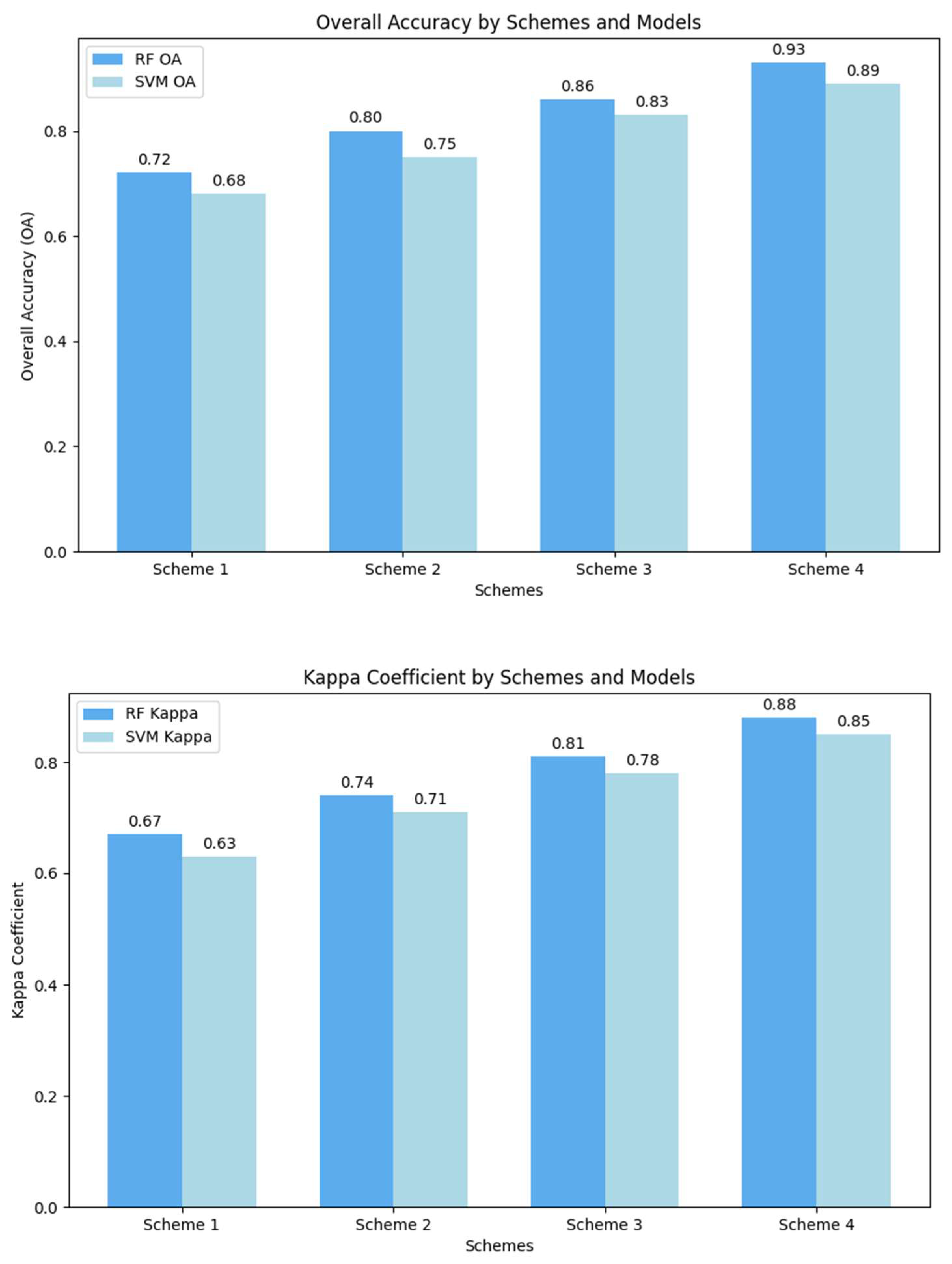
3.1. Comparative Analysis of Feature Combinations and Classification Accuracy
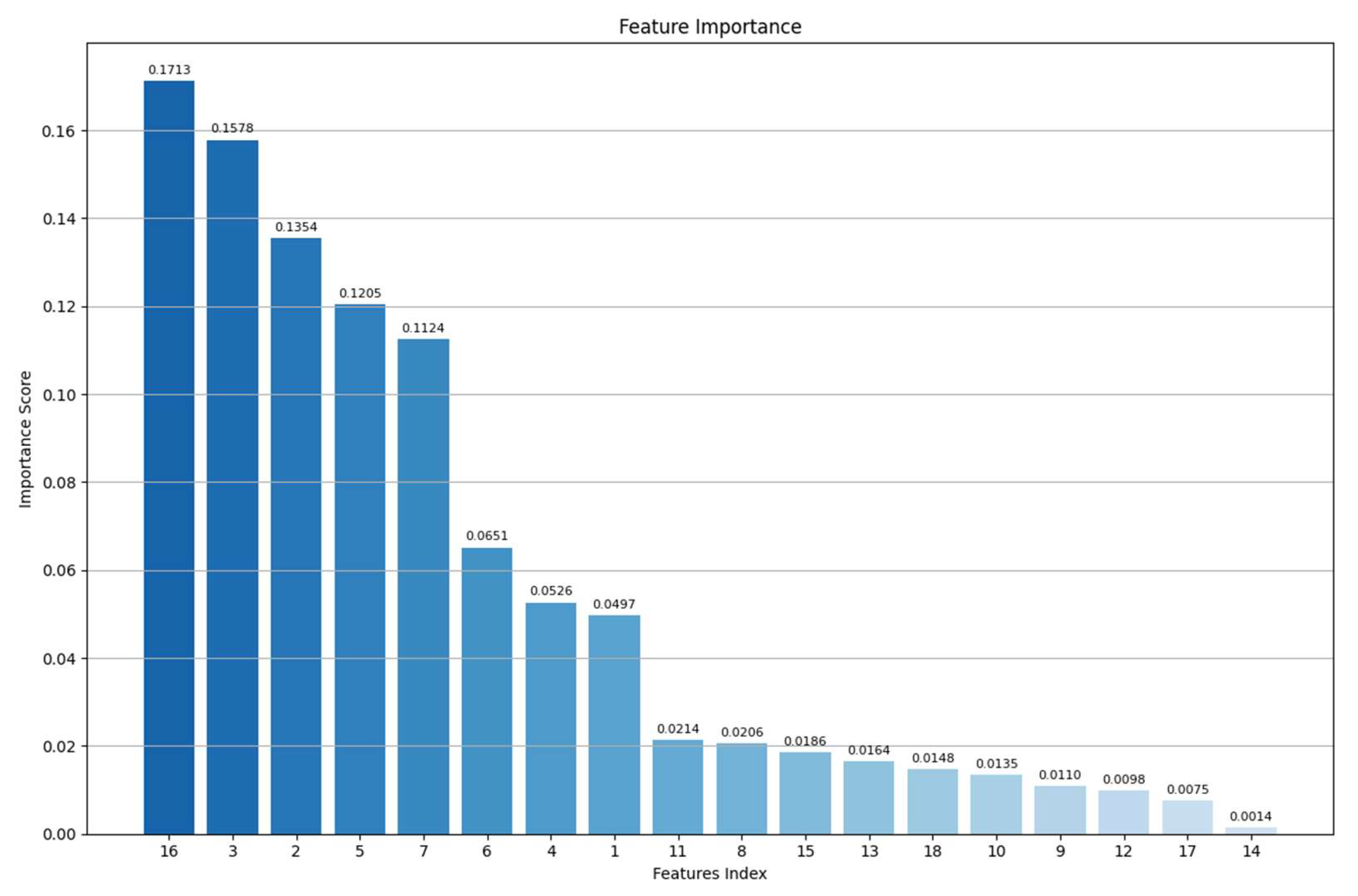
3.2. Feature Importance Analysis of Multi-Source Data
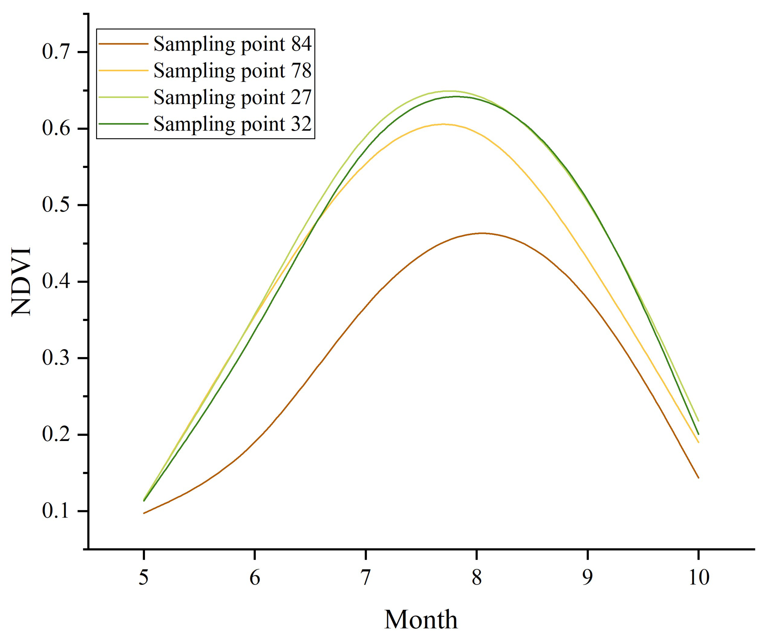
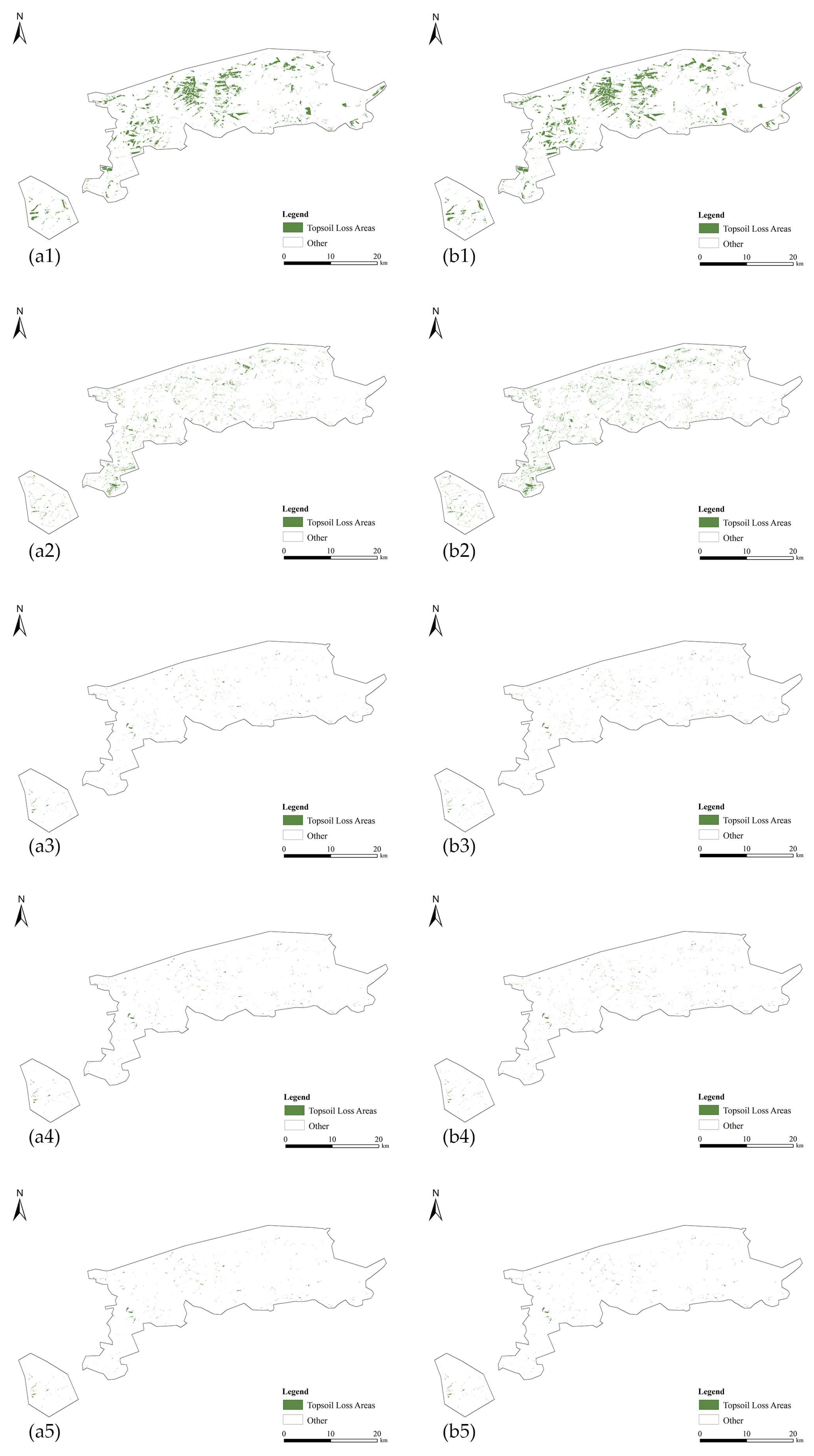
3.3. Spatial Distribution of TLA and Their Impact
4. Discussion
4.1. Analysis of the Necessity of Integrating Multi-Source Features
4.2. Uncertainty Analysis of Extraction Results
4.3. Limitations and Future Prospects
5. Conclusions
Author Contributions
Funding
Data Availability Statement
Acknowledgments
Conflicts of Interest
Appendix A


| Sampling Point | pH | SOM | TN | AN | AP | AK |
|---|---|---|---|---|---|---|
| 84 | 5.24 | 0.86545159 | 417.1182019 | 78.9684 | 21.725 | 89.2326 |
| 78 | 5.51 | 3.099368029 | 1293.14923 | 269.4216 | 25.225 | 111.216 |
| 27 | 5.86 | 3.78998068 | 1835.146267 | 309.68 | 20.775 | 99.0112 |
| 32 | 5.78 | 4.619941506 | 2025.65445 | 301.938 | 21.85 | 116.884 |
References
- Chen, J.; Chen, J.Z.; Tan, M.Z.; Gong, Z. Soil degradation: A global problem endangering sustainable development. J. Geogr. Sci. 2002, 12, 243–252. [Google Scholar]
- Lehmann, J.; Bossio, D.A.; Kögel-Knabner, I.; Rillig, M.C. The concept and future prospects of soil health. Nat. Rev. Earth Environ. 2020, 1, 544–553. [Google Scholar] [CrossRef] [PubMed]
- Patzold, S.; Mertens, F.M.; Bornemann, L.; Koleczek, B.; Franke, J.; Feilhauer, H.; Welp, G. Soil heterogeneity at the field scale: A challenge for precision crop protection. Precis. Agric. 2008, 9, 367–390. [Google Scholar] [CrossRef]
- Mulla, D.J.; McBratney, A.B. Soil spatial variability. In Soil Physics Companion; CRC Press: Boca Raton, FL, USA, 2001; pp. 343–373. [Google Scholar]
- Reynolds, H.L.; Haubensak, K.A. Soil fertility, heterogeneity, and microbes: Towards an integrated understanding of grassland structure and dynamics. Appl. Veg. Sci. 2009, 12, 33–44. [Google Scholar] [CrossRef]
- Pacheco, F.A.L.; Fernandes, L.F.S.; Junior, R.F.V.; Valera, C.A.; Pissarra, T.C.T. Land degradation: Multiple environmental consequences and routes to neutrality. Curr. Opin. Environ. Sci. Health 2018, 5, 79–86. [Google Scholar] [CrossRef]
- Prăvălie, R.; Patriche, C.; Borrelli, P.; Panagos, P.; Roșca, B.; Dumitrașcu, M.; Bandoc, G. Arable lands under the pressure of multiple land degradation processes. A global perspective. Environ. Res. 2021, 194, 110697. [Google Scholar] [CrossRef] [PubMed]
- Vågen, T.G.; Winowiecki, L.A. Predicting the spatial distribution and severity of soil erosion in the global tropics using satellite remote sensing. Remote Sens. 2019, 11, 1800. [Google Scholar] [CrossRef] [PubMed]
- Wang, H.; Yang, S.; Wang, Y.; Gu, Z.; Xiong, S.; Huang, X.; Sun, M.; Zhang, S.; Guo, L.; Cui, J.; et al. Rates and causes of black soil erosion in Northeast China. Catena 2022, 214, 106250. [Google Scholar] [CrossRef]
- Ma, S.; Wang, L.J.; Wang, H.Y.; Zhao, Y.G.; Jiang, J. Impacts of land use/land cover and soil property changes on soil erosion in the black soil region, China. J. Environ. Manag. 2023, 328, 117024. [Google Scholar] [CrossRef]
- Sun, Z.; Liu, F.; Wu, H.; Zhang, G.L. Development of a national black soil map of China through machine learning classification. Catena 2024, 240, 107993. [Google Scholar] [CrossRef]
- Han, X.; Li, N. Research progress of black soil in Northeast China. Sci. Geogr. Sin. 2018, 38, 1032–1041. [Google Scholar]
- Zhao, Z.; Zhang, C.; Wang, H.; Li, F.; Pan, H.; Yang, Q.; Zhang, J. The effects of natural humus material amendment on soil organic matter and integrated fertility in the black soil of Northeast China: Preliminary results. Agronomy 2023, 13, 794. [Google Scholar] [CrossRef]
- Liu, B.; Ye, Y.; Li, Z.; Liang, Y.; Zhang, W.; Fu, S.; Yin, S.; Wei, X. The assessment of soil loss by water erosion in China. Int. Soil Water Conserv. Res. 2020, 8, 430–439. [Google Scholar] [CrossRef]
- Wang, S.; Liang, X.; Wei, C. Spatial and temporal changes of erosion in the black soil region of Northeast China from 2000 to 2020. Ziyuan Kexue 2023, 45, 951–965. [Google Scholar] [CrossRef]
- Liu, J.; Han, X.; Chen, X.; He, R.; Wu, P. Prediction of soil thicknesses in a headwater hillslope with constrained sampling data. Catena 2019, 177, 101–113. [Google Scholar] [CrossRef]
- Qi, Z.J.; Zhang, Z.X.; Yang, A.Z. Benefit of soil and water conservation measures on sloped land of black soils. Res. Soil Water Conserv. 2011, 18, 72–75. [Google Scholar]
- Li, X.; Shi, Z.; Zhang, Z.; Wang, M.; Wang, M. Dynamic evaluation of cropland degradation risk by combining multi-temporal remote sensing and geographical data in the Black Soil Region of Jilin Province, China. Appl. Geogr. 2023, 154, 102920. [Google Scholar] [CrossRef]
- Thaler, E.A.; Larsen, I.J.; Yu, Q. The extent of soil loss across the US Corn Belt. Proc. Natl. Acad. Sci. USA 2021, 118, e1922375118. [Google Scholar] [CrossRef] [PubMed]
- Yu, H.; Chen, P.; Sun, Y. Analysis of the coupling and coordination between soil erosion and land use in the Northeastern black soil region of China: A case study of Lishu County. Sci. Rep. 2024, 14, 21955. [Google Scholar] [CrossRef]
- Han, X.Z.; Zou, W.X. Research Perspectives and Footprint of Utilization and Protection of Black Soil in Northeast China. Acta Pedol. Sin. 2021, 58, 1341–1358. [Google Scholar]
- Cui, J.; Guo, L.; Xiong, S.; Yang, S.; Wang, Y.; Zhang, S.; Sun, H. Soil organic carbon induces a decrease in erodibility of black soil with loess parent materials in Northeast China. Quat. Res. 2024, 120, 83–92. [Google Scholar] [CrossRef]
- Li, C.; Fu, B.; Wang, S.; Stringer, L.C.; Wang, Y.; Li, Z.; Zhou, W. Drivers and impacts of changes in China’s drylands. Nat. Rev. Earth Environ. 2021, 2, 858–873. [Google Scholar] [CrossRef]
- Shi, Y.; Yang, F.; Long, H.; Rossiter, D.G.; Zhang, A.; Zhang, G. Provenance of soil parent materials in relation to regional environmental changes in the Songnen Plain, Northeast China. Geoderma Reg. 2024, 38, e00848. [Google Scholar] [CrossRef]
- Alewell, C.; Borrelli, P.; Meusburger, K.; Panagos, P. Using the USLE: Chances, challenges and limitations of soil erosion modelling. Int. Soil Water Conserv. Res. 2019, 7, 203–225. [Google Scholar] [CrossRef]
- Borrelli, P.; Alewell, C.; Alvarez, P.; Anache, J.A.A.; Baartman, J.; Ballabio, C.; Bezak, N.; Biddoccu, M.; Cerdà, A.; Chalise, D.; et al. Soil erosion modelling: A global review and statistical analysis. Sci. Total Environ. 2021, 780, 146494. [Google Scholar] [CrossRef] [PubMed]
- Kulyanitsa, A.L.; Rukhovich, D.I.; Koroleva, P.V.; Vilchevskaya, E.V.; Kalinina, N.V. Analysis of the informativity of big satellite precision-farming data processing for correcting large-scale soil maps. Eurasian Soil Sci. 2020, 53, 1709–1725. [Google Scholar] [CrossRef]
- Liu, J.; Yang, K.; Tariq, A.; Lu, L.; Soufan, W.; El Sabagh, A. Interaction of climate, topography and soil properties with cropland and crop pattern using remote sensing data and machine learning methods. Egypt. J. Remote Sens. Space Sci. 2023, 26, 415–426. [Google Scholar]
- Bag, R.; Mondal, I.; Dehbozorgi, M.; Bank, S.P.; Das, D.N.; Bandyopadhyay, J.; Pham, Q.B.; Al-Quraishi, A.M.; Nguyen, X.C. Modelling and mapping of soil erosion susceptibility using machine learning in a tropical hot sub-humid environment. J. Clean. Prod. 2022, 364, 132428. [Google Scholar] [CrossRef]
- Schmid, T.; Rodríguez-Rastrero, M.; Escribano, P.; Palacios-Orueta, A.; Ben-Dor, E.; Plaza, A.; Milewski, R.; Huesca, M.; Bracken, A.; Cicuéndez, V.; et al. Characterization of soil erosion indicators using hyperspectral data from a Mediterranean rainfed cultivated region. IEEE J. Sel. Top. Appl. Earth Obs. Remote Sens. 2015, 9, 845–860. [Google Scholar] [CrossRef]
- Žížala, D.; Juřicová, A.; Zádorová, T.; Zelenková, K.; Minařík, R. Mapping soil degradation using remote sensing data and ancillary data: South-East Moravia, Czech Republic. Eur. J. Remote Sens. 2019, 52 (Suppl. S1), 108–122. [Google Scholar] [CrossRef]
- Zeng, X.; Guo, X.; Jiang, Y.; Li, W.; Guo, J.; Zhou, Q.; Zou, H. High-accuracy mapping of soil parent material types in hilly areas at the county scale using machine learning algorithms. Remote Sens. 2024, 16, 91. [Google Scholar] [CrossRef]
- Daviran, M.; Maghsoudi, A.; Ghezelbash, R. Optimized AI-MPM: Application of PSO for tuning the hyperparameters of SVM and RF algorithms. Comput. Geosci. 2025, 195, 105785. [Google Scholar] [CrossRef]
- Sheykhmousa, M.; Mahdianpari, M.; Ghanbari, H.; Mohammadimanesh, F.; Ghamisi, P.; Homayouni, S. Support vector machine versus random forest for remote sensing image classification: A meta-analysis and systematic review. IEEE J. Sel. Top. Appl. Earth Obs. Remote Sens. 2020, 13, 6308–6325. [Google Scholar] [CrossRef]
- Akbari, E.; Darvishi Boloorani, A.; Neysani Samany, N.; Hamzeh, S.; Soufizadeh, S.; Pignatti, S. Crop mapping using random forest and particle swarm optimization based on multi-temporal Sentinel-2. Remote Sens. 2020, 12, 1449. [Google Scholar] [CrossRef]
- Ramírez-Ochoa, D.D.; Pérez-Domínguez, L.A.; Martínez-Gómez, E.A.; Luviano-Cruz, D. PSO, a swarm intelligence-based evolutionary algorithm as a decision-making strategy: A review. Symmetry 2022, 14, 455. [Google Scholar] [CrossRef]
- Gao, B.C.; Goetz, A.; Wiscombe, W.J. Cirrus cloud detection from airborne imaging spectrometer data using the 1.38 μm water vapor band. Geophys. Res. Lett. 1993, 20, 301–304. [Google Scholar] [CrossRef]
- Shi, P.; Six, J.; Sila, A.; Vanlauwe, B.; Van Oost, K. Towards spatially continuous mapping of soil organic carbon in croplands using multitemporal Sentinel-2 remote sensing. ISPRS J. Photogramm. Remote Sens. 2022, 193, 187–199. [Google Scholar] [CrossRef]
- Olaya, V. Basic land-surface parameters. Dev. Soil Sci. 2009, 33, 141–169. [Google Scholar]
- Chen, T.; Peng, L.; Liu, S.; Wang, X.; Xu, D. Relationships of relief degree of topography with population and economy in Hengduan mountain area based on GIS. J. Univ. Chin. Acad. Sci. 2016, 33, 505. [Google Scholar]
- Lindsay, J.B.; Newman, D.R.; Francioni, A. Scale-Optimized Surface Roughness for Topographic Analysis. Geosciences 2019, 9, 322. [Google Scholar] [CrossRef]
- Lin, M.; Zhao, G.; Qin, Y. Extraction and Monitoring of Cotton Area and Growth Information Using Remote Sensing at Small Scale: A Case Study in Dingzhuang Town of Guangrao County, China. In Proceedings of the International Conference on Computer Distributed Control & Intelligent Environmental Monitoring, Changsha, China, 19–20 February 2011; IEEE: New York, NY, USA, 2011. [Google Scholar]
- Ribeiro, S.G.; Teixeira, A.D.S.; de Oliveira, M.R.R.; Costa, M.C.G.; Araújo, I.C.D.S.; Moreira, L.C.J.; Lopes, F.B. Soil organic carbon content prediction using soil-reflected spectra: A comparison of two regression methods. Remote Sens. 2021, 13, 4752. [Google Scholar] [CrossRef]
- Ambrosone, M.; Matese, A.; Di Gennaro, S.F.; Gioli, B.; Tudoroiu, M.; Genesio, L.; Miglietta, F.; Baronti, S.; Maienza, A.; Ungaro, F.; et al. Retrieving soil moisture in rainfed and irrigated fields using Sentinel-2 observations and a modified OPTRAM approach. Int. J. Appl. Earth Obs. Geoinf. 2020, 89, 102113. [Google Scholar] [CrossRef]
- Yang, Y.; Wu, J.; Mao, Y.; He, F.; Zhang, J.; Gao, C.; Pan, X.; Wang, Y. Effect of no-tillage on pore distribution in soil profile. Chin. J. Eco-Agric. 2018, 26, 1019–1028. [Google Scholar]
- Xiong, H.; Zhou, X.; Wang, X.; Cui, Y. Mapping the spatial distribution of tea plantations with 10 m resolution in Fujian province using Google Earth Engine. J. Geo-Inf. Sci. 2021, 23, 1325–1337. [Google Scholar]
- Kumar, B.; Dikshit, O.; Gupta, A.; Singh, M.K. Feature extraction for hyperspectral image classification: A review. Int. J. Remote Sens. 2020, 41, 6248–6287. [Google Scholar] [CrossRef]
- Tran, T.V.; Reef, R.; Zhu, X. A review of spectral indices for mangrove remote sensing. Remote Sens. 2022, 14, 4868. [Google Scholar] [CrossRef]
- Jin, X.; Song, K.; Du, J.; Liu, H.; Wen, Z. Comparison of different satellite bands and vegetation indices for estimation of soil organic matter based on simulated spectral configuration. Agric. For. Meteorol. 2017, 244, 57–71. [Google Scholar] [CrossRef]
- Rial, M.; Cortizas, A.M.; Rodríguez-Lado, L. Mapping soil organic carbon content using spectroscopic and environmental data: A case study in acidic soils from NW Spain. Sci. Total Environ. 2016, 539, 26–35. [Google Scholar] [CrossRef] [PubMed]
- Ben-Dor, E. Quantitative remote sensing of soil properties. In Remote Sensing for the Earth Sciences; Hill, J., Ed.; John Wiley & Sons: Hoboken, NJ, USA, 2002; pp. 173–243. [Google Scholar]
- Júnior, R.F.; Siqueira, H.E.; Valera, C.A.; Oliveira, C.F.; Fernandes, L.F.; Moura, J.P.; Pacheco, F.A. Diagnosis of degraded pastures using an improved NDVI-based remote sensing approach: An application to the environmental protection area of Uberaba River Basin (Minas Gerais, Brazil). Remote Sens. Appl. Soc. Environ. 2019, 14, 20–33. [Google Scholar]
- Senanayake, S.; Pradhan, B.; Huete, A.; Brennan, J. Spatial Modeling of Soil Erosion Hazards and Crop Diversity Change with Rainfall Variation in the Central Highlands of Sri Lanka. Sci. Total Environ. 2022, 806, 150405. [Google Scholar] [CrossRef] [PubMed]
- Beniaich, A.; Silva, M.L.; Guimarães, D.V.; Avalos, F.A.; Terra, F.S.; Menezes, M.D.; Avanzi, J.C.; Cândido, B.M. UAV-Based Vegetation Monitoring for Assessing the Impact of Soil Loss in Olive Orchards in Brazil. Geoderma Reg. 2022, 30, e00543. [Google Scholar] [CrossRef]
- Gholizadeh, A.; Žižala, D.; Saberioon, M.; Borůvka, L. Soil Organic Carbon and Texture Retrieving and Mapping Using Proximal, Airborne, and Sentinel-2 Spectral Imaging. Remote Sens. Environ. 2018, 218, 89–103. [Google Scholar] [CrossRef]
- Rock, B.N.; Williams, D.L.; Vogelmann, J.E. Field and Airborne Spectral Characterization of Suspected Acid Deposition Damage in Red Spruce (Picea rubens) from Vermont. In Proceedings of the 11th International Symposium—Machine Processing of Remotely Sensed Data, West Lafayette, IN, USA, 25–27 June 1985; pp. 71–81. [Google Scholar]
- Xiao, X.; Zhang, Q.; Braswell, B.; Urbanski, S.; Boles, S.; Wofsy, S.; Moore, B., III; Ojima, D. Modeling Gross Primary Production of Temperate Deciduous Broadleaf Forest Using Satellite Images and Climate Data. Remote Sens. Environ. 2004, 91, 256–270. [Google Scholar] [CrossRef]
- Deng, Y.; Wu, C.; Li, M.; Chen, R. RNDSI: A Ratio Normalized Difference Soil Index for Remote Sensing of Urban/Suburban Environments. Int. J. Appl. Earth Obs. Geoinf. 2015, 39, 40–48. [Google Scholar] [CrossRef]
- Chen, W.; Liu, L.; Zhang, C.; Wang, J.; Wang, J.; Pan, Y. Monitoring the Seasonal Bare Soil Areas in Beijing Using Multitemporal TM Images. In Proceedings of the IGARSS 2004: 2004 IEEE International Geoscience and Remote Sensing Symposium, Anchorage, AK, USA, 20–24 September 2004; IEEE: Piscataway, NJ, USA, 2004; pp. 3379–3382. [Google Scholar]
- Breiman, L. Random Forests. Mach. Learn. 2001, 45, 5–32. [Google Scholar] [CrossRef]
- He, Z.; Wang, J.; Jiang, M.; Hu, L.; Zou, Q. Random Subsequence Forests. Inf. Sci. 2024, 667, 120478. [Google Scholar] [CrossRef]
- Cortes, C. Support-Vector Networks. Mach. Learn. 1995, 20, 273–297. [Google Scholar] [CrossRef]
- Melgani, F.; Bruzzone, L. Classification of Hyperspectral Remote Sensing Images with Support Vector Machines. IEEE Trans. Geosci. Remote Sens. 2004, 42, 1778–1790. [Google Scholar] [CrossRef]
- Chandra, M.A.; Bedi, S.S. Survey on SVM and Their Application in Image Classification. Int. J. Inf. Technol. 2021, 13, 1–11. [Google Scholar] [CrossRef]
- Eberhart, R.; Kennedy, J. A New Optimizer Using Particle Swarm Theory. In Proceedings of the MHS’95: Proceedings of the Sixth International Symposium on Micro Machine and Human Science, Nagoya, Japan, 4–6 October 1995; IEEE: Piscataway, NJ, USA, 1995; pp. 39–43. [Google Scholar]
- Wagner, J.E.; Stehman, S.V. Optimizing Sample Size Allocation to Strata for Estimating Area and Map Accuracy. Remote Sens. Environ. 2015, 168, 126–133. [Google Scholar] [CrossRef]
- Li, T.; Zhao, L.; Duan, H.; Yang, Y.; Wang, Y.; Wu, F. Exploring the Interaction of Surface Roughness and Slope Gradient in Controlling Rates of Soil Loss from Sloping Farmland on the Loess Plateau of China. Hydrol. Process. 2020, 34, 339–354. [Google Scholar] [CrossRef]
- Peña-Barragán, J.M.; Ngugi, M.K.; Plant, R.E.; Six, J. Object-Based Crop Identification Using Multiple Vegetation Indices, Textural Features and Crop Phenology. Remote Sens. Environ. 2011, 115, 1301–1316. [Google Scholar] [CrossRef]


| Band | Central Wavelength (nm) | Bandwidth (nm) | Spatial Resolution (m) | SNR (at Lref) |
|---|---|---|---|---|
| B2 | 490 | 65 | 10 | 154 |
| B3 | 560 | 35 | 10 | 168 |
| B4 | 665 | 30 | 10 | 142 |
| B5 | 705 | 15 | 20 | 117 |
| B6 | 740 | 15 | 20 | 89 |
| B7 | 783 | 20 | 20 | 105 |
| B8 | 842 | 115 | 10 | 174 |
| B8A | 865 | 20 | 20 | 72 |
| B11 | 1610 | 90 | 20 | 100 |
| B12 | 2190 | 180 | 20 | 100 |
| Name | Index | Definition | Definition Based on Sentinel-2 |
|---|---|---|---|
| Normalized Difference Vegetation Index | NDVI | ||
| Enhanced Vegetation Index | EVI | ||
| Ratio Vegetation Index | RVI | ||
| Brightness Index | BI | ||
| Moisture Stress Index | MSI | ||
| Land Surface Water Index | LSWI | ||
| Normalized Difference Soil Index | NDSI | ||
| Bare Soil Index | BSI |
| Scheme | Model | OA | Kappa |
|---|---|---|---|
| Scheme 4 | PSO-RF | 0.97 | 0.94 |
| PSO-SVM | 0.94 | 0.90 |
| Feature No. | Feature Name | Description | Feature No. | Feature Name | Description |
|---|---|---|---|---|---|
| 1 | Band 2 | Blue spectral band | 10 | Band 12 | Short-wave infrared (SWIR) band |
| 2 | Band 3 | Green spectral band | 11 | DEM | Digital Elevation Model representing land surface elevation |
| 3 | Band 4 | Red spectral band | 12 | Slope | Gradient of the land surface |
| 4 | Band 5 | Vegetation red-edge band | 13 | Surface Roughness | Measure of surface texture and roughness |
| 5 | Band 6 | Vegetation red-edge band | 14 | Topographic Relief | Variation in elevation within a given area |
| 6 | Band 7 | Vegetation red-edge band | 15 | NDVI | Normalized Difference Vegetation Index |
| 7 | Band 8 | Near-infrared (NIR) band | 16 | BI | Brightness Index |
| 8 | Band 8A | Narrow NIR band | 17 | LSWI | Land Surface Water Index |
| 9 | Band 11 | Short-wave infrared (SWIR) band | 18 | NDSI | Normalized Difference Soil Index |
Disclaimer/Publisher’s Note: The statements, opinions and data contained in all publications are solely those of the individual author(s) and contributor(s) and not of MDPI and/or the editor(s). MDPI and/or the editor(s) disclaim responsibility for any injury to people or property resulting from any ideas, methods, instructions or products referred to in the content. |
© 2025 by the authors. Licensee MDPI, Basel, Switzerland. This article is an open access article distributed under the terms and conditions of the Creative Commons Attribution (CC BY) license (https://creativecommons.org/licenses/by/4.0/).
Share and Cite
Zhang, X.; Qin, C.; Ma, S.; Liu, J.; Wang, Y.; Liu, H.; An, Z.; Ma, Y. Study on the Extraction of Topsoil-Loss Areas of Cultivated Land Based on Multi-Source Remote Sensing Data. Remote Sens. 2025, 17, 547. https://doi.org/10.3390/rs17030547
Zhang X, Qin C, Ma S, Liu J, Wang Y, Liu H, An Z, Ma Y. Study on the Extraction of Topsoil-Loss Areas of Cultivated Land Based on Multi-Source Remote Sensing Data. Remote Sensing. 2025; 17(3):547. https://doi.org/10.3390/rs17030547
Chicago/Turabian StyleZhang, Xinle, Chuan Qin, Shinai Ma, Jiming Liu, Yiang Wang, Huanjun Liu, Zeyu An, and Yihan Ma. 2025. "Study on the Extraction of Topsoil-Loss Areas of Cultivated Land Based on Multi-Source Remote Sensing Data" Remote Sensing 17, no. 3: 547. https://doi.org/10.3390/rs17030547
APA StyleZhang, X., Qin, C., Ma, S., Liu, J., Wang, Y., Liu, H., An, Z., & Ma, Y. (2025). Study on the Extraction of Topsoil-Loss Areas of Cultivated Land Based on Multi-Source Remote Sensing Data. Remote Sensing, 17(3), 547. https://doi.org/10.3390/rs17030547