Representativeness Error Assessment and Multi-Method Scaling of HY-2B Altimeter Significant Wave Height
Highlights
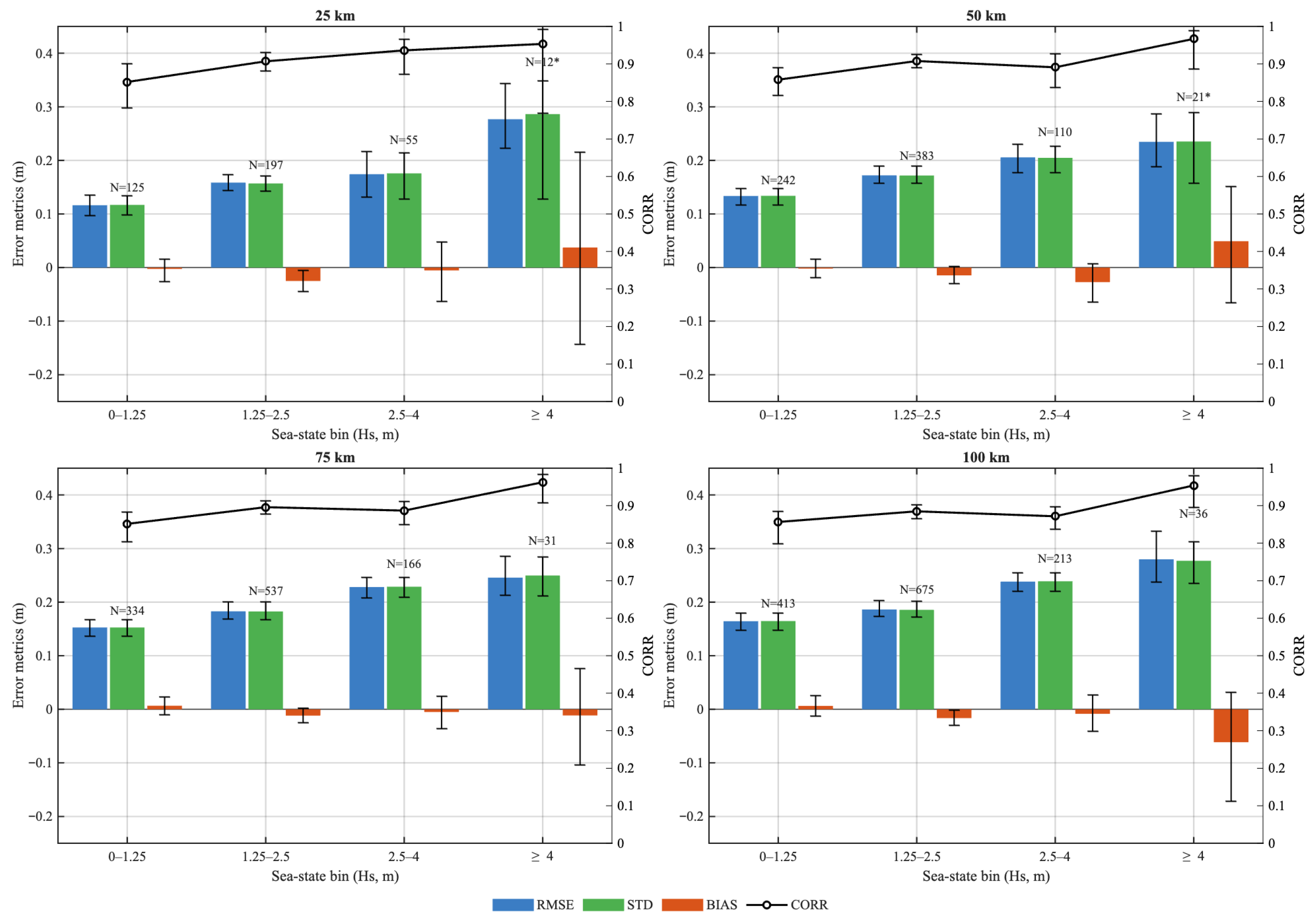
- HY-2B SWH performance is stable across heterogeneous sea states, with accuracy strongly controlled by collocation window selection.
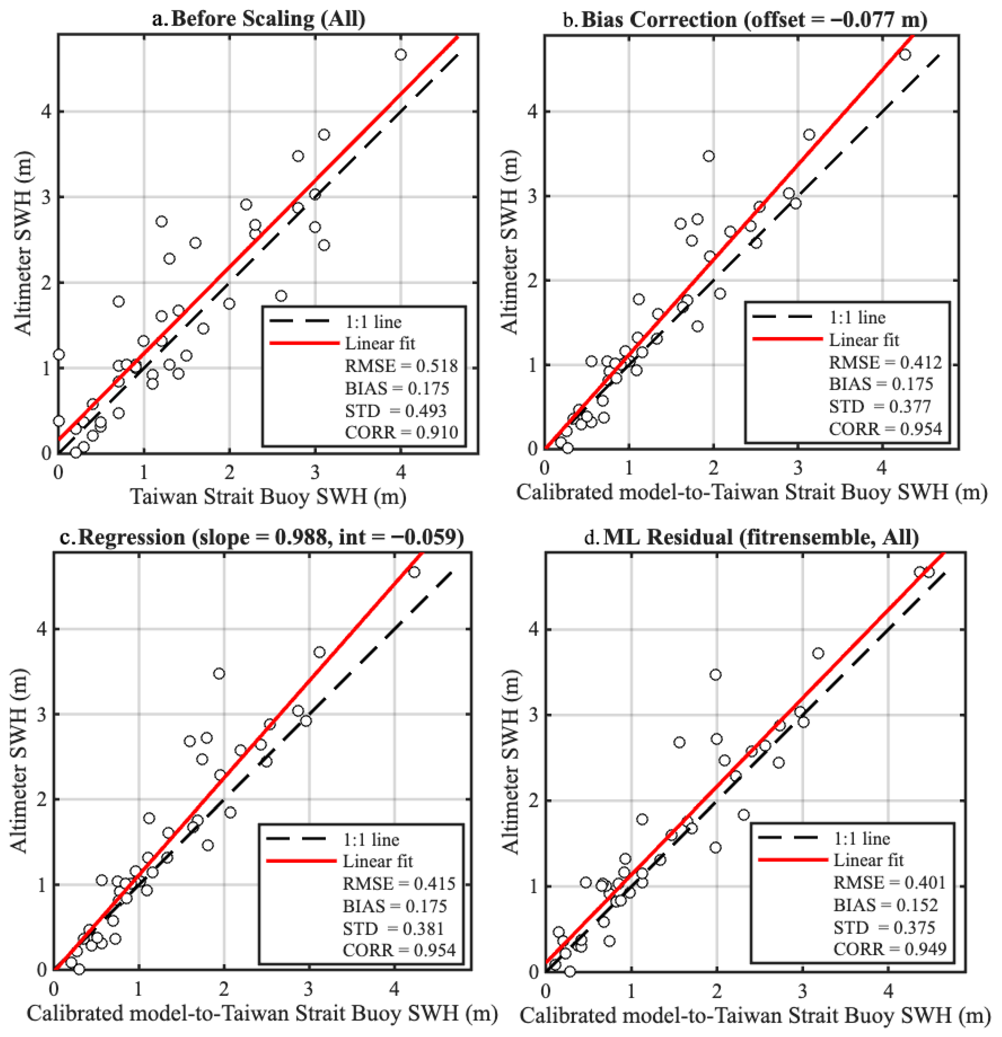
- HY-2B matches NDBC buoys closely, while Taiwan Strait matchups require bias/OLS/ML residual corrections to reduce coastal representativeness errors.
- The results support a data-quality-driven validation strategy using 30 min/25–50 km windows and selective scaling.
- The protocol is directly applicable to routine Cal/Val practice and transferable to future HY-series altimeter missions.
Abstract
1. Introduction
2. Materials and Methods
2.1. Buoy Data
2.2. Altimeter Data
2.3. Model Data
2.4. Collocation, QC, and Interpolation
2.5. Calibration Schemes: Bias, OLS, and ML Residual Correction
2.5.1. Bias Correction
2.5.2. OLS Linear Regression Scaling
2.5.3. Machine-Learning Residual Correction
3. Results and Discussion
3.1. Threshold Sensitivity
3.2. Overall and Sea-State-Binned Results
3.3. Scaling Performance: NDBC Versus Taiwan Strait Buoys
3.4. Extended Triple Collocation Results
3.5. Implications and Key Findings
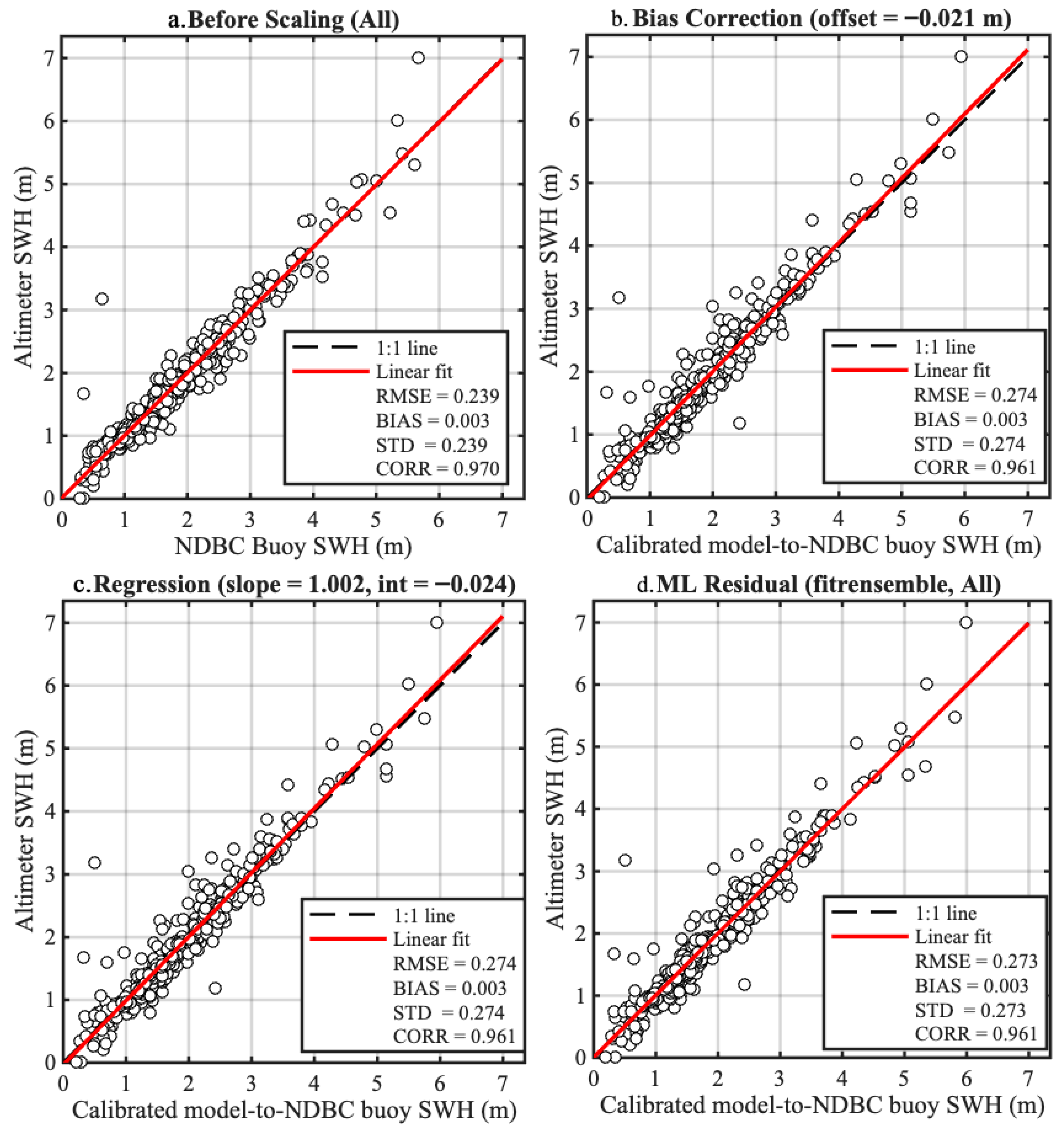
- For NDBC buoys with well-characterized uncertainties, buoy SWH requires no additional scaling. The satellite and buoy observations are already statistically consistent within their respective noise levels.
- For regional coastal buoys of good but less rigorously calibrated quality (Taiwan Strait), systematic and random errors are larger; here, our unified scaling framework—particularly the ML residual correction—provides a substantial reduction in random scatter and bias.
4. Conclusions
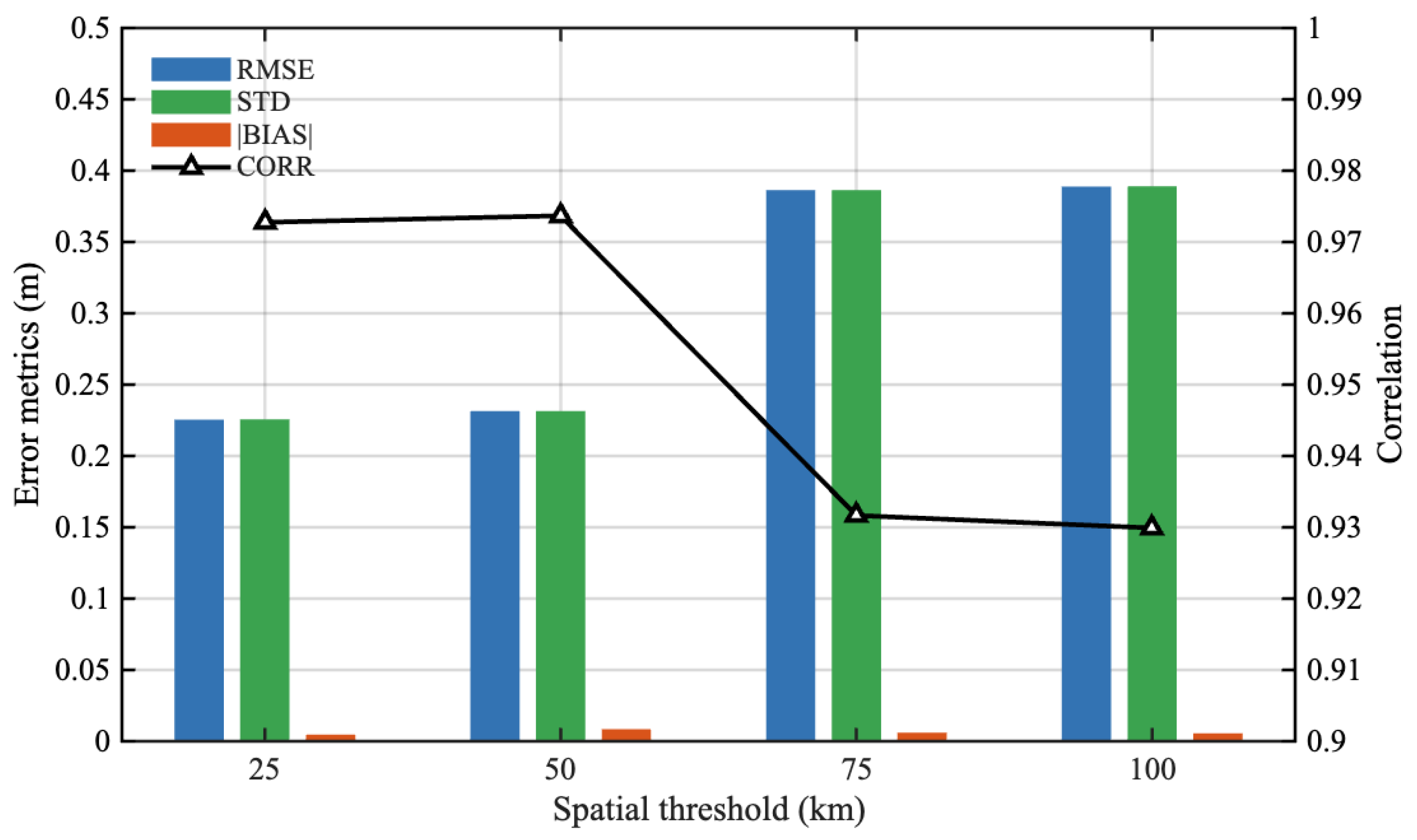
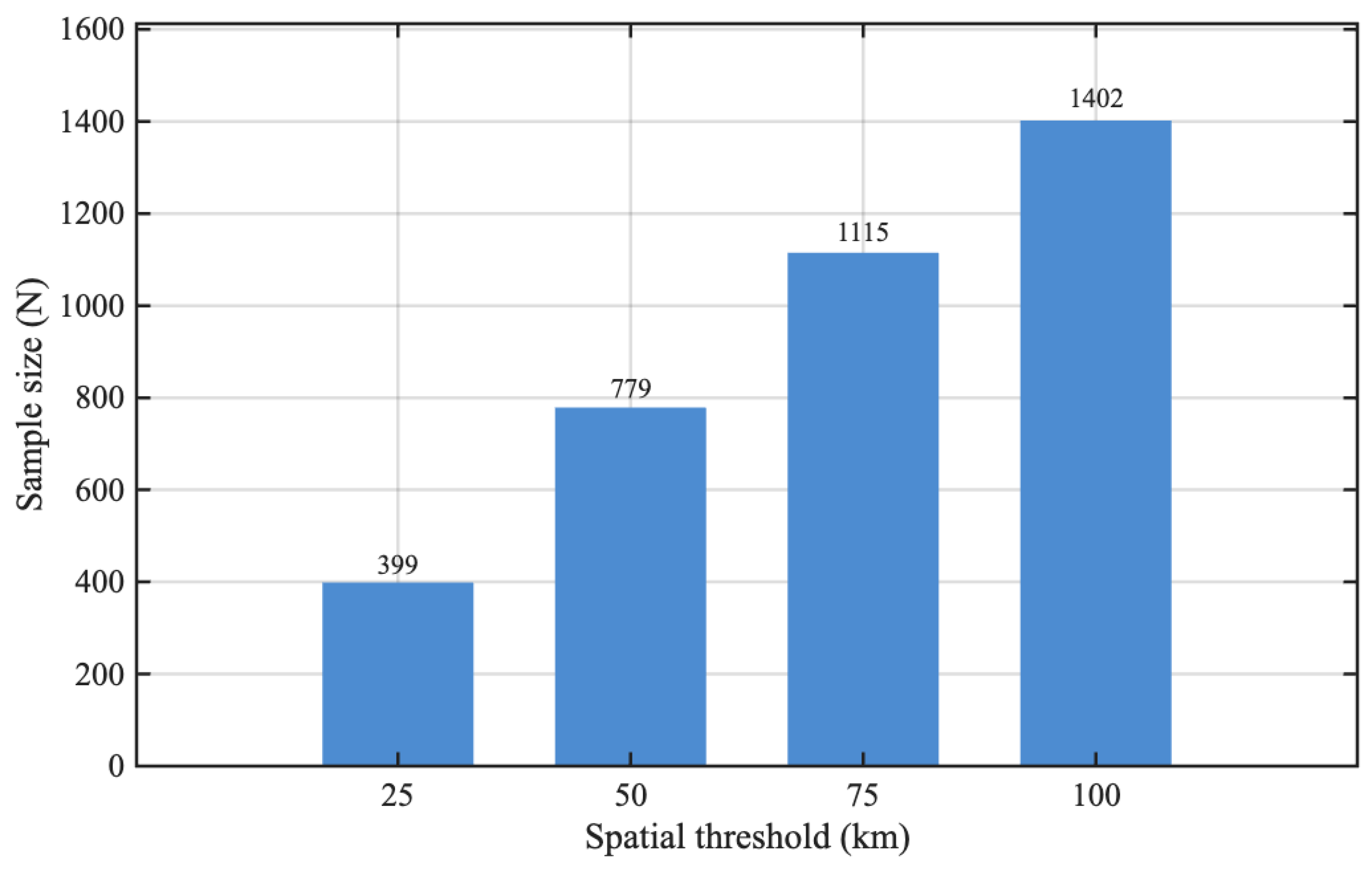
- Collocation sensitivity. Using NDBC buoys as a reference, spatial thresholds exert first-order control on performance. Narrow windows (25–50 km with 30 min) yield the lowest RMSE/STD and the highest correlations; broader windows increase sample size but degrade precision due to representativeness errors, especially at high sea state.
- Sea-state dependence. Across thresholds, RMSE/STD increase with SWH while mean biases remain small, indicating that error growth is dominated by random scatter rather than systematic offsets. Reporting sea-state-binned metrics is therefore recommended for operational validation.
- Data-quality-driven scaling. For high-quality NDBC matchups, HY-2B and buoy SWH are already consistent (e.g., RMSE ≈ 0.24 m), and bias/OLS/ML adjustments do not improve performance and may slightly increase scatter. In contrast, for Taiwan Strait buoys in a more heterogeneous coastal regime, all three schemes reduce errors, with the machine-learning residual correction providing the largest improvement (e.g., RMSE ≈ 0.40−0.41 m, correlation ≈ 0.95).
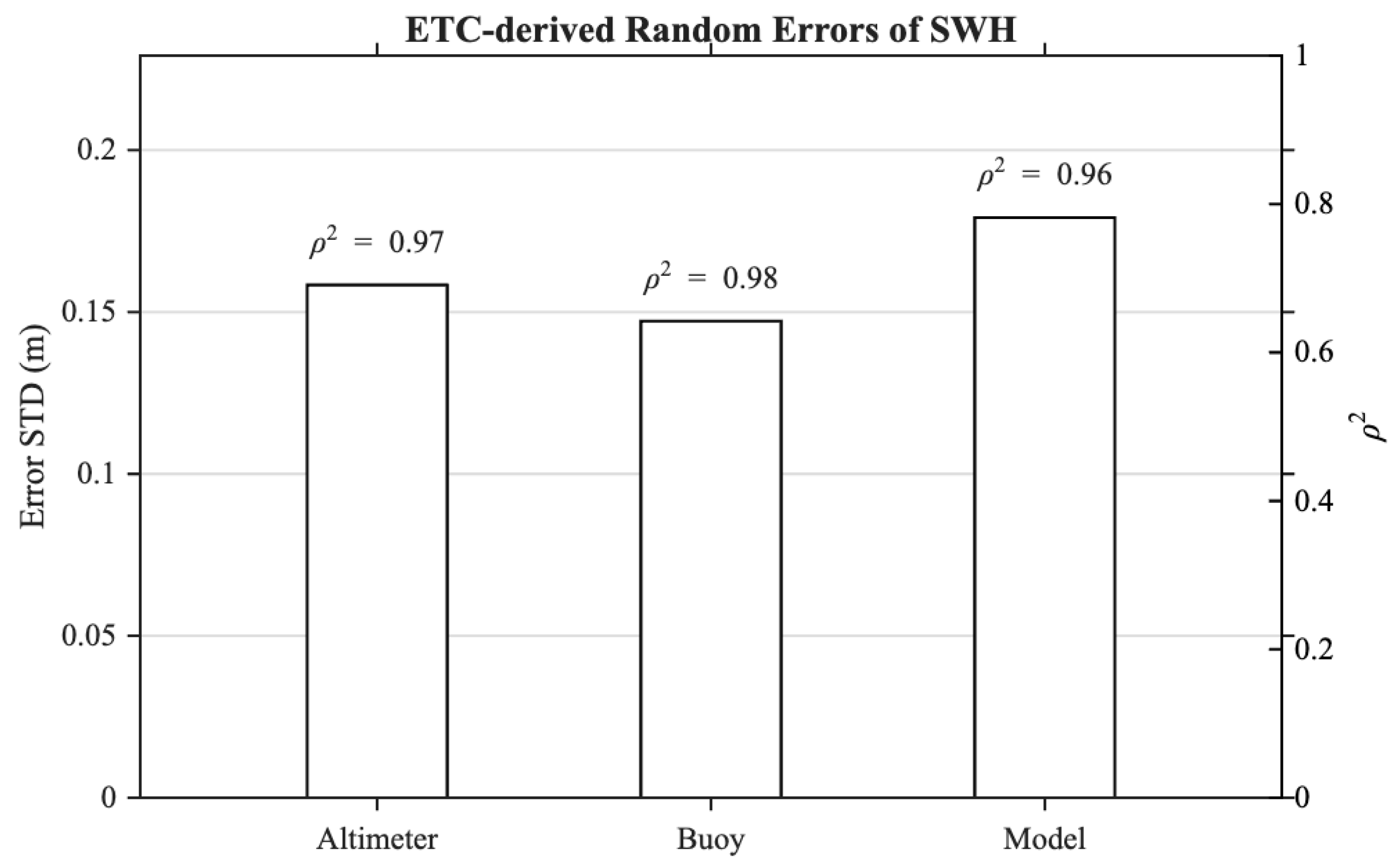
- Sensor-independent uncertainty. ETC applied to HY-2B, NDBC, and CMEMS over 2022–2023 indicates random error standard deviations of 0.158, 0.147, and 0.179 m, respectively, with consistently high (≈0.96–0.98), confirming strong coherence among the three systems at matchup scales.
Author Contributions
Funding
Institutional Review Board Statement
Informed Consent Statement
Data Availability Statement
Acknowledgments
Conflicts of Interest
References
- Ribal, A.; Young, I.R. 33 Years of Globally Calibrated Wave Height and Wind Speed Data Based on Altimeter Observations. Sci. Data 2019, 6, 77. [Google Scholar] [CrossRef] [PubMed]
- Young, I.R.; Ribal, A. Multiplatform Evaluation of Global Trends in Wind Speed and Wave Height. Science 2019, 364, 548–552. [Google Scholar] [CrossRef] [PubMed]
- Liu, Q.; Babanin, A.V.; Guan, C.; Zieger, S.; Sun, J.; Jia, Y. Calibration and Validation of HY-2 Altimeter Wave Height. J. Atmos. Ocean. Technol. 2016, 33, 919–936. [Google Scholar] [CrossRef]
- Qin, D.; Jia, Y.; Lin, M.; Liu, S. Performance Evaluation of China’s First Ocean Dynamic Environment Satellite Constellation. Remote Sens. 2023, 15, 4780. [Google Scholar] [CrossRef]
- Li, X.; Xu, Y.; Liu, B.; Lin, W.; He, Y.; Liu, J. Validation and Calibration of Nadir SWH Products From CFOSAT and HY-2B with Satellites and In Situ Observations. J. Geophys. Res. Ocean. 2021, 126, e2020JC016689. [Google Scholar] [CrossRef]
- Yang, J.; Zhang, J.; Jia, Y.; Fan, C.; Cui, W. Validation of Sentinel-3A/3B and Jason-3 Altimeter Wind Speeds and Significant Wave Heights Using Buoy and ASCAT Data. Remote Sens. 2020, 12, 2079. [Google Scholar] [CrossRef]
- Yang, L.; Xu, Y.; Lin, M.; Ma, C.; Mertikas, S.P.; Hu, W.; Wang, Z.; Mu, B.; Zhou, X. Monitoring the Performance of HY-2B and Jason-2/3 Sea Surface Height via the China Altimetry Calibration Cooperation Plan. IEEE Trans. Geosci. Remote Sens. 2022, 60, 1002013. [Google Scholar] [CrossRef]
- Zieger, S.; Vinoth, J.; Young, I.R. Joint Calibration of Multiplatform Altimeter Measurements of Wind Speed and Wave Height over the Past 20 Years. J. Atmos. Ocean. Technol. 2009, 26, 2549–2564. [Google Scholar] [CrossRef]
- Queffeulou, P. Long-Term Validation of Wave Height Measurements from Altimeters. Mar. Geod. 2004, 27, 495–510. [Google Scholar] [CrossRef]
- Wang, J.; Aouf, L.; Jia, Y.; Zhang, Y. Validation and Calibration of Significant Wave Height and Wind Speed Retrievals from HY2B Altimeter Based on Deep Learning. Remote Sens. 2020, 12, 2858. [Google Scholar] [CrossRef]
- Zhang, R.; Qi, J.; Yan, Q.; Fan, C.; Yang, Y.; Zhang, J.; Wan, Y. Calibration of CFOSAT Off-Nadir SWIM SWH Product Based on CNN-LSTM Model. Earth Space Sci. 2024, 11, e2023EA003386. [Google Scholar] [CrossRef]
- Wang, J.; Yu, T.; Deng, F.; Ruan, Z.; Jia, Y. Acquisition of the Wide Swath Significant Wave Height from HY-2C through Deep Learning. Remote Sens. 2021, 13, 4425. [Google Scholar] [CrossRef]
- Yang, J.; Zhang, J. Validation of Sentinel-3A/3B Satellite Altimetry Wave Heights with Buoy and Jason-3 Data. Sensors 2019, 19, 2914. [Google Scholar] [CrossRef] [PubMed]
- Peng, H.; Lin, M. Calibration of HY-2A Satellite Significant Wave Heights with in Situ Observation. Acta Oceanol. Sin. 2016, 35, 79–83. [Google Scholar] [CrossRef]
- Jiang, M.; Xu, K.; Liu, Y. Calibration and Validation of Reprocessed HY-2A Altimeter Wave Height Measurements Using Data from Buoys, Jason-2, Cryosat-2, and SARAL/AltiKa. J. Atmos. Ocean. Technol. 2018, 35, 1331–1352. [Google Scholar] [CrossRef]
- Durrant, T.H.; Greenslade, D.J.M.; Simmonds, I. Validation of Jason-1 and Envisat Remotely Sensed Wave Heights. J. Atmos. Ocean. Technol. 2009, 26, 123–134. [Google Scholar] [CrossRef]
- Zhu, B.; Chen, J.; Xu, Y.; Zheng, Q.; Li, X. Validation of the CFOSAT Scatterometer Data with Buoy Observations and Tests of Operational Application to Extreme Weather Forecasts in Taiwan Strait. Earth Space Sci. 2022, 9, e2021EA001865. [Google Scholar] [CrossRef]
- Quartly, G.D.; Kurekin, A.A. Sensitivity of Altimeter Wave Height Assessment to Data Selection. Remote Sens. 2020, 12, 2608. [Google Scholar] [CrossRef]
- Copernicus Marine Environment Monitoring Service (CMEMS). Product User Manual for Global Ocean Wave Multi Year Product; GLOBAL_MULTIYEAR_WAV_001_032; Mercator Ocean International: Toulouse, France, 2024; Issue 1.4. [Google Scholar]
- Campos, R.M. Analysis of Spatial and Temporal Criteria for Altimeter Collocation of Significant Wave Height and Wind Speed Data in Deep Waters. Remote Sens. 2023, 15, 2203. [Google Scholar] [CrossRef]
- Janssen, P.A.E.M.; Abdalla, S.; Hersbach, H.; Bidlot, J.R. Error Estimation of Buoy, Satellite, and Model Wave Height Data. J. Atmos. Ocean. Technol. 2007, 24, 1665–1677. [Google Scholar] [CrossRef]
- Caires, S.; Sterl, A. Validation of Ocean Wind and Wave Data Using Triple Collocation. J. Geophys. Res. Ocean. 2003, 108, 2002JC001491. [Google Scholar] [CrossRef]
- Stoffelen, A. Toward the True Near-surface Wind Speed: Error Modeling and Calibration Using Triple Collocation. J. Geophys. Res. Ocean. 1998, 103, 7755–7766. [Google Scholar] [CrossRef]
- Vogelzang, J.; Stoffelen, A.; Verhoef, A.; Figa-Saldaña, J. On the Quality of High-Resolution Scatterometer Winds. J. Geophys. Res. 2011, 116, C10033. [Google Scholar] [CrossRef]
- McColl, K.A.; Vogelzang, J.; Konings, A.G.; Entekhabi, D.; Piles, M.; Stoffelen, A. Extended Triple Collocation: Estimating Errors and Correlation Coefficients with Respect to an Unknown Target. Geophys. Res. Lett. 2014, 41, 6229–6236. [Google Scholar] [CrossRef]
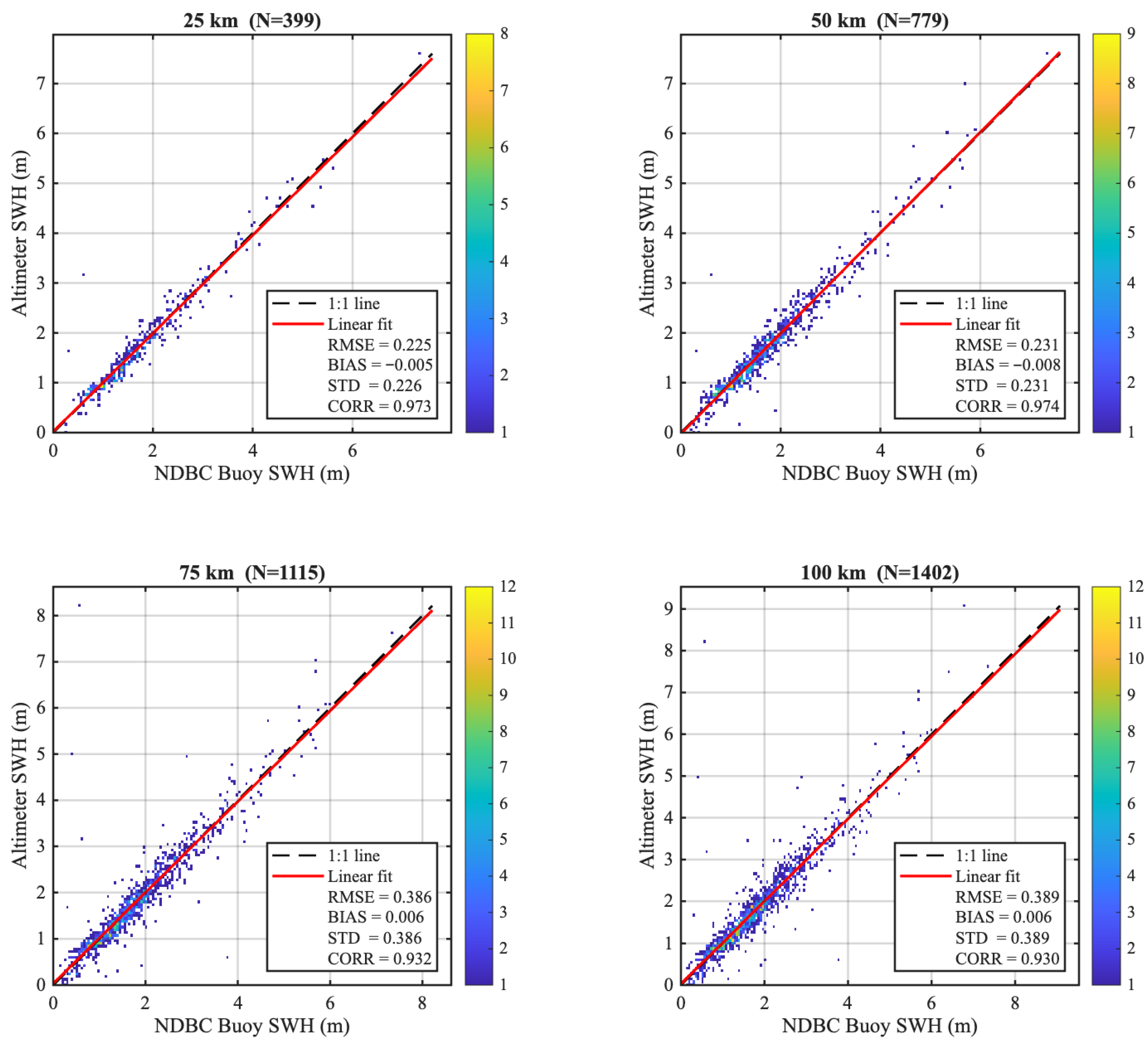
| Window (km) | Sample Size n | RMSE (m) | STD (m) |
|---|---|---|---|
| 25 | 399 | 0.225 | 0.226 |
| 50 | 779 | 0.231 | 0.231 |
| 75 | 1115 | 0.386 | 0.386 |
| 100 | 1402 | 0.389 | 0.389 |
| System | Error STD (m) | ||
|---|---|---|---|
| Altimeter | 0.15839 | 0.98738 | 0.97491 |
| Buoy | 0.14721 | 0.98842 | 0.97698 |
| Model | 0.17922 | 0.98222 | 0.96476 |
Disclaimer/Publisher’s Note: The statements, opinions and data contained in all publications are solely those of the individual author(s) and contributor(s) and not of MDPI and/or the editor(s). MDPI and/or the editor(s) disclaim responsibility for any injury to people or property resulting from any ideas, methods, instructions or products referred to in the content. |
© 2025 by the authors. Licensee MDPI, Basel, Switzerland. This article is an open access article distributed under the terms and conditions of the Creative Commons Attribution (CC BY) license (https://creativecommons.org/licenses/by/4.0/).
Share and Cite
Yang, S.; Zhang, L.; Peng, H.; Zhou, W.; Song, Q.; Mu, B.; Zhang, Y. Representativeness Error Assessment and Multi-Method Scaling of HY-2B Altimeter Significant Wave Height. Remote Sens. 2025, 17, 3829. https://doi.org/10.3390/rs17233829
Yang S, Zhang L, Peng H, Zhou W, Song Q, Mu B, Zhang Y. Representativeness Error Assessment and Multi-Method Scaling of HY-2B Altimeter Significant Wave Height. Remote Sensing. 2025; 17(23):3829. https://doi.org/10.3390/rs17233829
Chicago/Turabian StyleYang, Sheng, Lu Zhang, Hailong Peng, Wu Zhou, Qingjun Song, Bo Mu, and Yufei Zhang. 2025. "Representativeness Error Assessment and Multi-Method Scaling of HY-2B Altimeter Significant Wave Height" Remote Sensing 17, no. 23: 3829. https://doi.org/10.3390/rs17233829
APA StyleYang, S., Zhang, L., Peng, H., Zhou, W., Song, Q., Mu, B., & Zhang, Y. (2025). Representativeness Error Assessment and Multi-Method Scaling of HY-2B Altimeter Significant Wave Height. Remote Sensing, 17(23), 3829. https://doi.org/10.3390/rs17233829


