

Automated Mapping of Post-Storm Roof Damage Using Deep Learning and Aerial Imagery: A Case Study in the Caribbean


Highlights
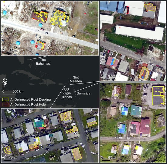
- We developed an end-to-end workflow for automated roof damage mapping using Esri ArcGIS Pro deep learning tools and post-hurricane aerial images acquired by drones and crewed aircraft in the Caribbean.
- The highest overall F1 scores were 0.88 (roof decking) and 0.80 (roof hole). Accuracies increased when single-class models were trained and when the training datasets were expanded to include representation of all four test areas.
- The data, tools, and trained models from this study can be downloaded and used to continue model training and testing in additional geographic and imaging contexts.
- Our deep learning methodology may be useful in real-world situations, at least for generating initial damage maps that are later refined by human analysts.
Abstract
1. Introduction
1.1. Background
1.2. Related Work and Research Needs
2. Materials and Methods
2.1. Study Area and Images

| Location | Category | Number of Orthomosaics | GSD (m) | Total Area (km2) 1 | Imaging Platform | Source |
|---|---|---|---|---|---|---|
| Dominica | Training | 50 | 0.03–0.08 | 20.29 | SkyRanger 2, M200 3 | GlobalMedic [117] |
| Sint Maarten | Training | 24 | 0.02–0.08 | 11.77 | SkyRanger 2, M200 3 | GlobalMedic [117] |
| All | 74 | 0.02–0.08 | 32.06 | |||
| Dominica | Testing | 4 | 0.04 | 1.75 | M200 3 | GlobalMedic [117] |
| Sint Maarten | Testing | 4 | 0.03–0.08 | 1.62 | SkyRanger 2 | GlobalMedic [117] |
| The Bahamas | Testing | 1 | 0.05 | 0.51 | M200 3 | GlobalMedic [117] |
| US Virgin Islands | Testing | 1 | 0.15 | 0.47 | Crewed aircraft 4 | US NOAA NGS [118] |
| All | 10 | 0.03–0.15 | 4.35 |

2.2. Image Preparation
2.3. Training and Reference Polygon Creation
2.4. Training Data Export
2.5. Model Configuration and Training
2.6. Model Inference and Post-Processing
2.7. Accuracy Assessment
2.8. Additional Training Data Incorporation
| Location | Category | Number of Polygons (Decking) | Total Polygon Area (m2) 1 | Average Polygon Area (m2) 1 | Number of Polygons (Hole) | Total Polygon Area (m2) 1 | Average Polygon Area (m2) 1 |
|---|---|---|---|---|---|---|---|
| The Bahamas | Training | 250 | 2982.58 | 11.93 | 250 | 4300.40 | 17.20 |
| US Virgin Islands | Training | 250 | 14,220.17 | 56.88 | 250 | 3537.09 | 14.15 |
| All | 500 | 17,202.75 | 34.41 | 500 | 7837.49 | 15.67 |


3. Results
3.1. Single-Class Versus Dual-Class Modeling
3.2. Additional Training Data Incorporation
3.2.1. Impact on Accuracy of Each Damage Class
3.2.2. Impact on Accuracy in Each Test Location
3.2.3. Differences in Scene Complexity Between All Training Areas
3.3. Strengths and Weaknesses of the Best-Performing Models
3.3.1. True Positives
3.3.2. False Positives
3.3.3. False Negatives
3.3.4. Summary
4. Discussion
4.1. Recommended Modeling Approach
4.1.1. Single-Class Modeling
4.1.2. Geographic and Imaging Inclusion
4.1.3. Comprehensively Labeled Training Data
4.2. Comparison to Previous Studies
4.3. Application Limitations and Extensions
4.4. Recommended Future Research
5. Conclusions
Author Contributions
Funding
Data Availability Statement
Acknowledgments
Conflicts of Interest
Abbreviations
| 3D | Three-dimensional |
| API | Application programming interface |
| CPU | Central processing unit |
| DSM | Digital surface model |
| FEMA | Federal Emergency Management Agency |
| FN | False negative |
| FP | False positive |
| GIS | Geographic information system |
| GPU | Graphics processing unit |
| GSD | Ground sample distance |
| IoU | Intersection over union |
| Lidar | Light detection and ranging |
| NGS | National Geodetic Survey |
| NOAA | National Oceanic and Atmospheric Administration |
| px | Pixel |
| RAM | Random access memory |
| RGB | Red, green, blue |
| TP | True positive |
| USD | United States dollar |
References
- CRED; UNDRR. Human Cost of Disasters: An Overview of the Last 20 Years 2000–2019; UNDRR: Geneva, Switzerland, 2020. [Google Scholar]
- NOAA. Saffir-Simpson Hurricane Wind Scale. Available online: https://www.nhc.noaa.gov/aboutsshws.php (accessed on 5 July 2025).
- Larsen, B.; Graham, T.; Aisbett, B. A survey to identify physically demanding tasks performed during storm damage operations by Australian State Emergency Services personnel. Appl. Ergon. 2013, 44, 128–133. [Google Scholar] [CrossRef]
- Webb, S.; Weinstein Sheffield, E. Mindful Sheltering. Available online: https://alnap.org/help-library/resources/mindful-sheltering/ (accessed on 29 June 2022).
- USACE. Temporary Roofing Level 2: On-Site Assessment. Available online: https://www.youtube.com/watch?v=Rv5tVFXeyu4&list=PL9jyI6yEwMbiAAmHj4EICLNhlrlsasf-2 (accessed on 5 July 2025).
- UN OCHA. Emergency Team Responds to Philippines Devastation. Available online: https://reliefweb.int/report/philippines/emergency-team-responds-philippines-devastation (accessed on 5 July 2025).
- UN OCHA. Staying Dry from the Rain: Red Cross Improves Living Conditions for Families Affected by Hurricane Matthew. Available online: https://reliefweb.int/report/haiti/staying-dry-rain-red-cross-improves-living-conditions-families-affected-hurricane (accessed on 5 July 2025).
- UN OCHA. Shelter Cluster Vanuatu—TC Harold Situation Report No. 13 (10 July 2020). Available online: https://reliefweb.int/report/vanuatu/shelter-cluster-vanuatu-tc-harold-situation-report-no-13-10-july-2020 (accessed on 5 July 2025).
- UN OCHA. Mozambique Cyclone Idai and Cyclone Kenneth Response: Situation Report #13 (1 October–31 December 2019). Available online: https://reliefweb.int/report/mozambique/mozambique-cyclone-idai-and-cyclone-kenneth-response-situation-report-13-1-october (accessed on 5 July 2025).
- UNICEF. UNICEF Belize Humanitarian Situation Report #3, 16 August 2016. Available online: https://reliefweb.int/report/belize/unicef-belize-humanitarian-situation-report-3-16-august-2016 (accessed on 5 July 2025).
- IOM. IOM to Provide Temporary Roofing Solutions for Houses Affected by Hurricane Dorian in the Bahamas. Available online: https://www.iom.int/news/iom-provide-temporary-roofing-solutions-houses-affected-hurricane-dorian-bahamas (accessed on 5 July 2025).
- USACE. Operation Blue Roof. Available online: https://www.usace.army.mil/Missions/Emergency-Operations/Blue-Roof-Info/ (accessed on 5 July 2025).
- US Army. Mobile District Host Operation Blue Roof Deployers. Available online: https://www.army.mil/article/280761/mobile_district_host_operation_blue_roof_deployers (accessed on 5 July 2025).
- Ma, L.; Liu, Y.; Zhang, X.; Ye, Y.; Yin, G.; Johnson, B.A. Deep learning in remote sensing applications: A meta-analysis and review. ISPRS J. Photogramm. Remote Sens. 2019, 152, 166–177. [Google Scholar] [CrossRef]
- Cheng, G.; Xie, X.; Han, J.; Guo, L.; Xia, G.-S. Remote Sensing Image Scene Classification Meets Deep Learning: Challenges, Methods, Benchmarks, and Opportunities. IEEE J. Sel. Top. Appl. Earth Obs. Remote Sens. 2020, 13, 3735–3756. [Google Scholar] [CrossRef]
- Zhu, X.X.; Tuia, D.; Mou, L.; Xia, G.-S.; Zhang, L.; Xu, F.; Fraundorfer, F. Deep Learning in Remote Sensing: A Comprehensive Review and List of Resources. IEEE Geosci. Remote Sens. Mag. 2017, 5, 8–36. [Google Scholar] [CrossRef]
- Maxwell, A.E.; Warner, T.A.; Guillén, L.A. Accuracy Assessment in Convolutional Neural Network-Based Deep Learning Remote Sensing Studies—Part 1: Literature Review. Remote Sens. 2021, 13, 2450. [Google Scholar] [CrossRef]
- Cheng, B.; Misra, I.; Schwing, A.G.; Kirillov, A.; Girdhar, R. Masked-attention Mask Transformer for Universal Image Segmentation. In Proceedings of the 2022 IEEE/CVF Conference on Computer Vision and Pattern Recognition (CVPR), New Orleans, LA, USA, 18–24 June 2022; pp. 1280–1289. [Google Scholar]
- Gibril, M.B.A.; Al-Ruzouq, R.; Shanableh, A.; Jena, R.; Bolcek, J.; Shafri, H.Z.M.; Ghorbanzadeh, O. Transformer-based semantic segmentation for large-scale building footprint extraction from very-high resolution satellite images. Adv. Sp. Res. 2024, 73, 4937–4954. [Google Scholar] [CrossRef]
- Liu, Y.; Li, E.; Liu, W.; Li, X.; Zhu, Y. LFEMAP-Net: Low-Level Feature Enhancement and Multiscale Attention Pyramid Aggregation Network for Building Extraction From High-Resolution Remote Sensing Images. IEEE J. Sel. Top. Appl. Earth Obs. Remote Sens. 2024, 17, 2718–2730. [Google Scholar] [CrossRef]
- Zheng, L.; Pu, X.; Zhang, S.; Xu, F. Tuning a SAM-Based Model With Multicognitive Visual Adapter to Remote Sensing Instance Segmentation. IEEE J. Sel. Top. Appl. Earth Obs. Remote Sens. 2025, 18, 2737–2748. [Google Scholar] [CrossRef]
- Song, L.; Gao, Y.; Gui, Y.; Jiang, D.; Zhang, M.; Liu, H.; Li, W. LHAS: A Lightweight Network Based on Hierarchical Attention for Hyperspectral Image Segmentation. IEEE Trans. Geosci. Remote Sens. 2025, 63, 5508012. [Google Scholar] [CrossRef]
- Guo, S.; Yang, Q.; Xiang, S.; Wang, S.; Wang, X. Mask2Former with Improved Query for Semantic Segmentation in Remote-Sensing Images. Mathematics 2024, 12, 765. [Google Scholar] [CrossRef]
- Wei, R.; Fan, B.; Wang, Y.; Yang, R. A Query-Based Network for Rural Homestead Extraction from VHR Remote Sensing Images. Sensors 2023, 23, 3643. [Google Scholar] [CrossRef]
- Cai, W.; Jin, K.; Hou, J.; Guo, C.; Wu, L.; Yang, W. VDD: Varied Drone Dataset for semantic segmentation. J. Vis. Commun. Image Represent. 2025, 109, 104429. [Google Scholar] [CrossRef]
- Qian, Z.; Chen, M.; Sun, Z.; Zhang, F.; Xu, Q.; Guo, J.; Xie, Z.; Zhang, Z. Simultaneous extraction of spatial and attributional building information across large-scale urban landscapes from high-resolution satellite imagery. Sustain. Cities Soc. 2024, 106, 105393. [Google Scholar] [CrossRef]
- Xiao, Y.; Lin, L.; Ma, J.; Bi, M. Enhancing Rooftop Photovoltaic Segmentation Using Spatial Feature Reconstruction and Multi-Scale Feature Aggregation. Energies 2025, 18, 119. [Google Scholar] [CrossRef]
- Tran, M.; De Luis, A.; Liao, H.; Huang, Y.; McCann, R.; Mantooth, A.; Cothren, J.; Le, N. S3Former: A Deep Learning Approach to High Resolution Solar PV Profiling. IEEE Trans. Smart Grid 2025, 16, 2611–2623. [Google Scholar] [CrossRef]
- García, G.; Aparcedo, A.; Nayak, G.K.; Ahmed, T.; Shah, M.; Li, M. Generalized deep learning model for photovoltaic module segmentation from satellite and aerial imagery. Sol. Energy 2024, 274, 112539. [Google Scholar] [CrossRef]
- Niu, Z.; Xi, K.; Liao, Y.; Tao, P.; Ke, T. A Practical Framework for Estimating Façade Opening Rates of Rural Buildings Using Real-Scene 3D Models Derived from Unmanned Aerial Vehicle Photogrammetry. Remote Sens. 2025, 17, 1596. [Google Scholar] [CrossRef]
- Qiao, W.; Shen, L.; Wang, W.; Li, Z. A Weakly Supervised Bitemporal Scene Change Detection Approach for Pixel-Level Building Damage Assessment Using Pre- and Post-Disaster High-Resolution Remote Sensing Images. IEEE Trans. Geosci. Remote Sens. 2024, 62, 5648523. [Google Scholar] [CrossRef]
- Fujita, S.; Hatayama, M. Collapsed Building Detection Using Multiple Object Tracking from Aerial Videos and Analysis of Effective Filming Techniques of Drones. In Information Technology in Disaster Risk Reduction, Proceedings of the 7th IFIP WG 5.15 International Conference, ITDRR 2022, Kristiansand, Norway, 12–14 October 2022; Gjøsæter, T., Radianti, J., Murayama, Y., Eds.; IFIP Advances in Information and Communication Technology; Springer Nature: Cham, Switzerland, 2023; Volume 672, pp. 118–135. ISBN 978-3-031-34206-6. [Google Scholar]
- Abdi, G.; Esfandiari, M.; Jabari, S. A deep transfer learning-based damage assessment on post-event very high-resolution orthophotos. Geomatica 2022, 75, 237–250. [Google Scholar] [CrossRef]
- Zhang, H.; Wang, M.; Zhang, Y.; Ma, G. TDA-Net: A Novel Transfer Deep Attention Network for Rapid Response to Building Damage Discovery. Remote Sens. 2022, 14, 3687. [Google Scholar] [CrossRef]
- Pan, K.; Gonsoroski, E.; Uejio, C.K.; Beitsch, L.; Sherchan, S.P.; Lichtveld, M.Y.; Harville, E.W. Remotely sensed measures of Hurricane Michael damage and adverse perinatal outcomes and access to prenatal care services in the Florida panhandle. Environ. Health 2022, 21, 118. [Google Scholar] [CrossRef]
- Kalantar, B.; Ueda, N.; Al-Najjar, H.A.H.; Halin, A.A. Assessment of convolutional neural network architectures for earthquake-induced building damage detection based on pre- and post-event orthophoto images. Remote Sens. 2020, 12, 3529. [Google Scholar] [CrossRef]
- Jing, Y.; Ren, Y.; Liu, Y.; Wang, D.; Yu, L. Automatic Extraction of Damaged Houses by Earthquake Based on Improved YOLOv5: A Case Study in Yangbi. Remote Sens. 2022, 14, 382. [Google Scholar] [CrossRef]
- Valentijn, T.; Margutti, J.; van den Homberg, M.; Laaksonen, J. Multi-hazard and spatial transferability of a CNN for automated building damage assessment. Remote Sens. 2020, 12, 2839. [Google Scholar] [CrossRef]
- Scott, P.; Liang, D. Analysis of residential building performance in tornadoes as a function of building and hazard characteristics. In Proceedings of the 9th Asia-Pacific Conference on Wind Engineering, Auckland, New Zealand, 3–7 December 2017; pp. 5–8. [Google Scholar]
- Massarra, C.C.; Friedland, C.J.; Marx, B.D.; Dietrich, J.C. Predictive multi-hazard hurricane data-based fragility model for residential homes. Coast. Eng. 2019, 151, 10–21. [Google Scholar] [CrossRef]
- Rhee, D.M.; Nevill, J.B.; Lombardo, F.T. Comparison of Near-Surface Wind Speed Estimation Techniques Using Different Damage Indicators from a Damage Survey of Naplate, IL EF-3 Tornado. Nat. Hazards Rev. 2022, 23, 04021052. [Google Scholar] [CrossRef]
- Lin, D.; Wang, J.; Li, Y. Unsupervised building damage identification using post-event optical imagery and variational autoencoder. IEICE Trans. Inf. Syst. 2021, E104D, 1770–1774. [Google Scholar] [CrossRef]
- Tingzon, I.; Cowan, N.M.; Chrzanowski, P. Fusing VHR Post-disaster Aerial Imagery and LiDAR Data for Roof Classification in the Caribbean. In Proceedings of the 2023 IEEE/CVF International Conference on Computer Vision Workshops (ICCVW), Paris, France, 2–6 October 2023; IEEE: Piscataway, NJ, USA, 2023; pp. 3742–3749. [Google Scholar]
- Xu, J.; Zeng, F.; Liu, W.; Takahashi, T. Damage Detection and Level Classification of Roof Damage after Typhoon Faxai Based on Aerial Photos and Deep Learning. Appl. Sci. 2022, 12, 4912. [Google Scholar] [CrossRef]
- Zhou, Z.; Gong, J.; Hu, X. Community-scale multi-level post-hurricane damage assessment of residential buildings using multi-temporal airborne LiDAR data. Autom. Constr. 2019, 98, 30–45. [Google Scholar] [CrossRef]
- Mohammadi, M.E.; Wood, R.L. Machine Learning-Based Structural Damage Identification Within Three-Dimensional Point Clouds; Cury, A., Ribeiro, D., Ubertini, F., Todd, M.D., Eds.; Structural Integrity; Springer Nature: Cham, Switzerland, 2022; Volume 21, ISBN 978-3-030-81715-2. [Google Scholar]
- Boin, J.-B.; Roth, N.; Doshi, J.; Llueca, P.; Borensztein, N. Multi-class segmentation under severe class imbalance: A case study in roof damage assessment. In Proceedings of the 34th Conference on Neural Information Processing Systems (NeurIPS 2020), Online, 6–12 December 2020; pp. 1–8. [Google Scholar]
- Naito, S.; Tomozawa, H.; Mori, Y.; Nagata, T.; Monma, N.; Nakamura, H.; Fujiwara, H.; Shoji, G. Building-damage detection method based on machine learning utilizing aerial photographs of the Kumamoto earthquake. Earthq. Spectra 2020, 36, 1166–1187. [Google Scholar] [CrossRef]
- Zhou, Z.; Gong, J. Automated Analysis of Mobile LiDAR Data for Component-Level Damage Assessment of Building Structures during Large Coastal Storm Events. Comput. Civ. Infrastruct. Eng. 2018, 33, 373–392. [Google Scholar] [CrossRef]
- Gueguen, L.; Pesaresi, M.; Gerhardinger, A.; Soille, P. Characterizing and Counting Roofless Buildings in Very High Resolution Optical Images. IEEE Geosci. Remote Sens. Lett. 2012, 9, 114–118. [Google Scholar] [CrossRef]
- Calton, L.; Wei, Z. Using Artificial Neural Network Models to Assess Hurricane Damage through Transfer Learning. Appl. Sci. 2022, 12, 1466. [Google Scholar] [CrossRef]
- Fujita, S.; Hatayama, M. Estimation Method for Roof-damaged Buildings from Aero-Photo Images During Earthquakes Using Deep Learning. Inf. Syst. Front. 2021, 25, 351–363. [Google Scholar] [CrossRef]
- Mohammadi, M.E.; Watson, D.P.; Wood, R.L. Deep Learning-Based Damage Detection from Aerial SfM Point Clouds. Drones 2019, 3, 68. [Google Scholar] [CrossRef]
- Yu, K.; Wang, S.; Wang, Y.; Gu, Z.; Wang, Y. DBA-RTMDet: A High-Precision and Real-Time Instance Segmentation Method for Identification of Damaged Buildings in Post-Earthquake UAV Imagery. IEEE J. Sel. Top. Appl. Earth Obs. Remote Sens. 2025, 18, 19577–19593. [Google Scholar] [CrossRef]
- Ji, M.; Liu, L.; Du, R.; Buchroithner, M.F. A Comparative Study of Texture and Convolutional Neural Network Features for Detecting Collapsed Buildings After Earthquakes Using Pre- and Post-Event Satellite Imagery. Remote Sens. 2019, 11, 1202. [Google Scholar] [CrossRef]
- Ji, M.; Liu, L.; Buchroithner, M. Identifying Collapsed Buildings Using Post-Earthquake Satellite Imagery and Convolutional Neural Networks: A Case Study of the 2010 Haiti Earthquake. Remote Sens. 2018, 10, 1689. [Google Scholar] [CrossRef]
- Wang, B.; Tan, X.; Song, D.; Zhang, L. Rapid Identification of Post-Earthquake Collapsed Buildings via Multi-Scale Morphological Profiles With Multi-Structuring Elements. IEEE Access 2020, 8, 122036–122056. [Google Scholar] [CrossRef]
- Xiu, H.; Shinohara, T.; Matsuoka, M.; Inoguchi, M.; Kawabe, K.; Horie, K. Collapsed Building Detection Using 3D Point Clouds and Deep Learning. Remote Sens. 2020, 12, 4057. [Google Scholar] [CrossRef]
- Pi, Y.; Nath, N.D.; Behzadan, A.H. Detection and Semantic Segmentation of Disaster Damage in UAV Footage. J. Comput. Civ. Eng. 2021, 35, 04020063. [Google Scholar] [CrossRef]
- Liao, Y.; Mohammadi, M.E.; Wood, R.L. Deep Learning Classification of 2D Orthomosaic Images and 3D Point Clouds for Post-Event Structural Damage Assessment. Drones 2020, 4, 24. [Google Scholar] [CrossRef]
- Kakooei, M.; Baleghi, Y. Fusion of satellite, aircraft, and UAV data for automatic disaster damage assessment. Int. J. Remote Sens. 2017, 38, 2511–2534. [Google Scholar] [CrossRef]
- Thomas, J.; Kareem, A.; Bowyer, K.W. Automated poststorm damage classification of low-rise building roofing systems using high-resolution aerial imagery. IEEE Trans. Geosci. Remote Sens. 2014, 52, 3851–3861. [Google Scholar] [CrossRef]
- He, M.; Zhu, Q.; Du, Z.; Hu, H.; Ding, Y.; Chen, M. A 3D Shape Descriptor Based on Contour Clusters for Damaged Roof Detection Using Airborne LiDAR Point Clouds. Remote Sens. 2016, 8, 189. [Google Scholar] [CrossRef]
- Axel, C.; van Aardt, J. Building damage assessment using airborne lidar. J. Appl. Remote Sens. 2017, 11, 1. [Google Scholar] [CrossRef]
- Qiao, W.; Shen, L.; Wen, Q.; Wen, Q.; Tang, S.; Li, Z. Revolutionizing building damage detection: A novel weakly supervised approach using high-resolution remote sensing images. Int. J. Digit. Earth 2024, 17, 2298245. [Google Scholar] [CrossRef]
- Zhan, Y.; Liu, W.; Maruyama, Y. Damaged Building Extraction Using Modified Mask R-CNN Model Using Post-Event Aerial Images of the 2016 Kumamoto Earthquake. Remote Sens. 2022, 14, 1002. [Google Scholar] [CrossRef]
- Fujita, S.; Hatayama, M. Automatic Calculation of Damage Rate of Roofs Based on Image Segmentation. In Information Technology in Disaster Risk Reduction, Proceedings of the 6th IFIP WG 5.15 International Conference, ITDRR 2021, Morioka, Japan, 25–27 October 2021; Sasaki, J., Murayama, Y., Velev, D., Zlateva, P., Eds.; IFIP Advances in Information and Communication Technology; Springer Nature: Cham, Switzerland, 2022; Volume 638, pp. 3–22. ISBN 978-3-031-04169-3. [Google Scholar]
- Yu, K.; Wang, S.; Wang, Y.; Gu, Z. High-Quality Damaged Building Instance Segmentation Based on Improved Mask Transfiner Using Post-Earthquake UAS Imagery: A Case Study of the Luding Ms 6.8 Earthquake in China. Remote Sens. 2024, 16, 4222. [Google Scholar] [CrossRef]
- Tennant, E.; Jenkins, S.F.; Miller, V.; Robertson, R.; Wen, B.; Yun, S.-H.; Taisne, B. Automating tephra fall building damage assessment using deep learning. Nat. Hazards Earth Syst. Sci. 2024, 24, 4585–4608. [Google Scholar] [CrossRef]
- Zou, R.; Liu, J.; Pan, H.; Tang, D.; Zhou, R. An Improved Instance Segmentation Method for Fast Assessment of Damaged Buildings Based on Post-Earthquake UAV Images. Sensors 2024, 24, 4371. [Google Scholar] [CrossRef]
- Mittal, P.V.; Bafna, R.; Mittal, A. Unsupervised learning framework for region-based damage assessment on xBD, a large satellite imagery. Nat. Hazards 2023, 118, 1619–1643. [Google Scholar] [CrossRef]
- Miura, H.; Aridome, T.; Matsuoka, M. Deep learning-based identification of collapsed, non-collapsed and blue tarp-covered buildings from post-disaster aerial images. Remote Sens. 2020, 12, 1924. [Google Scholar] [CrossRef]
- Adams, S.M.; Levitan, M.L.; Friedland, C.J. High resolution imagery collection for post-disaster studies utilizing unmanned aircraft systems (UAS). Photogramm. Eng. Remote Sens. 2014, 80, 1161–1168. [Google Scholar] [CrossRef]
- Kijewski-Correa, T.L.; Kennedy, A.B.; Taflanidis, A.A.; Prevatt, D.O. Field reconnaissance and overview of the impact of Hurricane Matthew on Haiti’s Tiburon Peninsula. Nat. Hazards 2018, 94, 627–653. [Google Scholar] [CrossRef]
- Kovar, R.N.; Brown-Giammanco, T.M.; Lombardo, F.T. Leveraging Remote-Sensing Data to Assess Garage Door Damage and Associated Roof Damage. Front. Built Environ. 2018, 4, 61. [Google Scholar] [CrossRef]
- Amini, M.; Memari, A.M. Review of Literature on Performance of Coastal Residential Buildings under Hurricane Conditions and Lessons Learned. J. Perform. Constr. Facil. 2020, 34, 04020102. [Google Scholar] [CrossRef]
- Meloy, N.; Sen, R.; Pai, N.; Mullins, G. Roof Damage in New Homes Caused by Hurricane Charley. J. Perform. Constr. Facil. 2007, 21, 97–107. [Google Scholar] [CrossRef]
- Miura, H.; Murata, Y.; Wakasa, H.; Takara, T. Empirical estimation based on remote sensing images of insured typhoon-induced economic losses from building damage. Int. J. Disaster Risk Reduct. 2022, 82, 103334. [Google Scholar] [CrossRef]
- Pratt, K.S.; Murphy, R.; Stover, S.; Griffin, C. CONOPS and autonomy recommendations for VTOL small unmanned aerial system based on Hurricane Katrina operations. J. F. Robot. 2009, 26, 636–650. [Google Scholar] [CrossRef]
- Aránguiz, R.; Saez, B.; Gutiérrez, G.; Oyarzo-Vera, C.; Nuñez, E.; Quiñones, C.; Bobadilla, R.; Bull, M.T. Damage assessment of the May 31st, 2019, Talcahuano tornado, Chile. Int. J. Disaster Risk Reduct. 2020, 50, 101853. [Google Scholar] [CrossRef]
- Rey, T.; Leone, F.; Candela, T.; Belmadani, A.; Palany, P.; Krien, Y.; Cécé, R.; Gherardi, M.; Péroche, M.; Zahibo, N. Coastal Processes and Influence on Damage to Urban Structures during Hurricane Irma (St-Martin & St-Barthélemy, French West Indies). J. Mar. Sci. Eng. 2019, 7, 215. [Google Scholar]
- Roueche, D.B.; Chen, G.; Soto, M.G.; Kameshwar, S.; Safiey, A.; Do, T.; Lombardo, F.T.; Nakayama, J.O.; Rittelmeyer, B.M.; Palacio-Betancur, A.; et al. Performance of Hurricane-Resistant Housing during the 2022 Arabi, Louisiana, Tornado. J. Struct. Eng. 2024, 150, 04024029. [Google Scholar] [CrossRef]
- Schaefer, M.; Teeuw, R.; Day, S.; Zekkos, D.; Weber, P.; Meredith, T.; van Westen, C.J. Low-cost UAV surveys of hurricane damage in Dominica: Automated processing with co-registration of pre-hurricane imagery for change analysis. Nat. Hazards 2020, 101, 755–784. [Google Scholar] [CrossRef]
- Stevenson, S.A.; Miller, C.S.; Sills, D.M.L.; Kopp, G.A.; Rhee, D.M.; Lombardo, F.T. Assessment of wind speeds along the damage path of the Alonsa, Manitoba EF4 tornado on 3 August 2018. J. Wind Eng. Ind. Aerodyn. 2023, 238, 105422. [Google Scholar] [CrossRef]
- Calantropio, A.; Chiabrando, F.; Sammartano, G.; Spanò, A.; Teppati Losè, L. UAV strategies validation and remote sensing data for damage assessment in post-disaster scenarios. Int. Arch. Photogramm. Remote Sens. Spat. Inf. Sci. 2018, XLII-3/W4, 121–128. [Google Scholar] [CrossRef]
- de Bruijn, J.A.; Daniell, J.E.; Pomonis, A.; Gunasekera, R.; Macabuag, J.; de Ruiter, M.C.; Koopman, S.J.; Bloemendaal, N.; de Moel, H.; Aerts, J.C.J.H. Using rapid damage observations for Bayesian updating of hurricane vulnerability functions: A case study of Hurricane Dorian using social media. Int. J. Disaster Risk Reduct. 2022, 72, 102839. [Google Scholar] [CrossRef]
- Alzarrad, A.; Awolusi, I.; Hatamleh, M.T.; Terreno, S. Automatic assessment of roofs conditions using artificial intelligence (AI) and unmanned aerial vehicles (UAVs). Front. Built Environ. 2022, 8, 1026225. [Google Scholar] [CrossRef]
- Hezaveh, M.M.; Kanan, C.; Salvaggio, C. Roof Damage Assessment using Deep Learning. In Proceedings of the 2017 IEEE Applied Imagery Pattern Recognition Workshop (AIPR), Washington, DC, USA, 10–12 October 2017; IEEE: Piscataway, NJ, USA, 2017; pp. 6403–6408. [Google Scholar]
- Loerch, A.C.; Stow, D.A.; Coulter, L.L.; Nara, A.; Frew, J. Comparing the Accuracy of sUAS Navigation, Image Co-Registration and CNN-Based Damage Detection between Traditional and Repeat Station Imaging. Geosciences 2022, 12, 401. [Google Scholar] [CrossRef]
- Zhang, Y.; Kong, L.; Antwi-Afari, M.F.; Zhang, Q. An Integrated Method Using a Convolutional Autoencoder, Thresholding Techniques, and a Residual Network for Anomaly Detection on Heritage Roof Surfaces. Buildings 2024, 14, 2828. [Google Scholar] [CrossRef]
- Gong, J.; Maher, A. Use of Mobile Lidar Data to Assess Hurricane Damage and Visualize Community Vulnerability. Transp. Res. Rec. J. Transp. Res. Board 2014, 2459, 119–126. [Google Scholar] [CrossRef]
- Kashani, A.G.; Crawford, P.S.; Biswas, S.K.; Graettinger, A.J.; Grau, D. Automated Tornado Damage Assessment and Wind Speed Estimation Based on Terrestrial Laser Scanning. J. Comput. Civ. Eng. 2015, 29, 04014051. [Google Scholar] [CrossRef]
- Kashani, A.G.; Graettinger, A.J.; Dao, T. Lidar-Based Methodology to Evaluate Fragility Models for Tornado-Induced Roof Damage. Nat. Hazards Rev. 2016, 17, 04016006. [Google Scholar] [CrossRef]
- Gong, J. A Remote Sensing-based Approach for Assessing and Visualizing Post-Sandy Damage and Resiliency Rebuilding Needs. In Proceedings of the Construction Research Congress 2014, Atlanta, Georgia, 19–21 May 2014; American Society of Civil Engineers: Reston, VA, USA, 2014; pp. 1259–1268. [Google Scholar]
- Khoshelham, K.; Oude Elberink, S.; Xu, S. Segment-Based Classification of Damaged Building Roofs in Aerial Laser Scanning Data. IEEE Geosci. Remote Sens. Lett. 2013, 10, 1258–1262. [Google Scholar] [CrossRef]
- Kashani, A.G.; Olsen, M.J.; Graettinger, A.J. Laser Scanning Intensity Analysis for Automated Building Wind Damage Detection. In Proceedings of the Computing in Civil Engineering 2015, Austin, TX, USA, 21–23 June 2015; American Society of Civil Engineers: Reston, VA, USA, 2015; pp. 199–205. [Google Scholar]
- Fiorillo, F.; Perfetti, L.; Cardani, G. Automated Mapping of the roof damage in historic buildings in seismic areas with UAV photogrammetry. Procedia Struct. Integr. 2023, 44, 1672–1679. [Google Scholar] [CrossRef]
- Li, S.; Tang, H. Classification of Building Damage Triggered by Earthquakes Using Decision Tree. Math. Probl. Eng. 2020, 2020, 2930515. [Google Scholar] [CrossRef]
- Li, S.; Tang, H. Building damage extraction triggered by earthquake using the UAV imagery. Int. Arch. Photogramm. Remote Sens. Spat. Inf. Sci.-ISPRS Arch. 2018, 42, 929–936. [Google Scholar] [CrossRef]
- Li, S.; Tang, H.; He, S.; Shu, Y.; Mao, T.; Li, J.; Xu, Z. Unsupervised Detection of Earthquake-Triggered Roof-Holes From UAV Images Using Joint Color and Shape Features. IEEE Geosci. Remote Sens. Lett. 2015, 12, 1823–1827. [Google Scholar]
- Liu, C.; Sui, H.; Huang, L. Identification of Damaged Building Regions from High- Resolution Images Using Superpixel-Based Gradient and Autocorrelation Analysis. IEEE J. Sel. Top. Appl. Earth Obs. Remote Sens. 2021, 14, 1010–1024. [Google Scholar] [CrossRef]
- Lucks, L.; Bulatov, D.; Thönnessen, U.; Böge, M. Superpixel-wise Assessment of Building Damage from Aerial Images. In Proceedings of the 14th International Joint Conference on Computer Vision, Imaging and Computer Graphics Theory and Applications (VISIGRAPP 2019), Prague, Czech Republic, 25–27 February 2019; SciTePress—Science and Technology Publications: Setúbal, Portugal, 2019; Volume 4, pp. 211–220. [Google Scholar]
- Tu, J.; Sui, H.; Feng, W.; Sun, K.; Hua, L. Detection of Damaged Rooftop Areas from High-Resolution Aerial Images Based on Visual Bag-of-Words Model. IEEE Geosci. Remote Sens. Lett. 2016, 13, 1817–1821. [Google Scholar] [CrossRef]
- Böge, M.; Bulatov, D.; Lucks, L. Localization and Grading of Building Roof Damages in High-Resolution Aerial Images. In Computer Vision, Imaging and Computer Graphics Theory and Applications, Proceedings of the 14th International Joint Conference, VISIGRAPP 2019, Prague, Czech Republic, 25–27 February 2019; Cláudio, A.P., Bouatouch, K., Chessa, M., Paljic, A., Kerren, A., Hurter, C., Tremeau, A., Farinella, G.M., Eds.; Communications in Computer and Information Science; Springer Nature: Cham, Switzerland, 2020; Volume 1182, pp. 497–519. ISBN 978-3-030-41589-1. [Google Scholar]
- McNamara, D.; Mell, W.; Maranghides, A. Object-based post-fire aerial image classification for building damage, destruction and defensive actions at the 2012 Colorado Waldo Canyon Fire. Int. J. Wildl. Fire 2020, 29, 174–189. [Google Scholar] [CrossRef]
- Radhika, S.; Tamura, Y.; Matsui, M. Strong Wind-Damaged Roof Detection from Post-Storm Aerial Images. In Proceedings of the Eighth Asia-Pacific Conference on Wind Engineering, Chennai, India, 10–14 December 2013; Research Publishing Services: Singapore, 2013; pp. 1122–1128. [Google Scholar]
- Radhika, S.; Tamura, Y.; Matsui, M. Determination of Degree of Damage on Building Roofs Due to Wind Disaster from Close Range Remote Sensing Images Using Texture Wavelet Analysis. In Proceedings of the IGARSS 2018—2018 IEEE International Geoscience and Remote Sensing Symposium, Valencia, Spain, 22–27 July 2018; IEEE: Piscataway, NJ, USA, 2018; pp. 3366–3369. [Google Scholar]
- Radhika, S.; Tamura, Y.; Matsui, M. Application of Remote-Sensing Images for Post-Wind Storm Damage Analysis. In Remote Sensing of Hydrometeorological Hazards; CRC Press: Boca Raton, FL, USA, 2017; pp. 417–435. ISBN 9781498777599. [Google Scholar]
- Radhika, S.; Tamura, Y.; Matsui, M. Texture-wavelet analysis for automating wind damage detection from aerial imageries. In Proceedings of the 2013 3rd IEEE International Advance Computing Conference (IACC), Ghaziabad, India, 22–23 February 2013; pp. 1246–1250. [Google Scholar]
- Chen, S.C.; Shyu, M.L.; Zhang, C.; Tang, W.Z.; Zhang, K. Damage pattern mining in Hurricane image databases. In Proceedings of the Proceedings Fifth IEEE Workshop on Mobile Computing Systems and Applications, Las Vegas, NV, USA, 27–29 October 2003; pp. 227–234. [Google Scholar]
- Liu, C.; Sui, H.; Huang, L. Identification of Building Damage from UAV-Based Photogrammetric Point Clouds Using Supervoxel Segmentation and Latent Dirichlet Allocation Model. Sensors 2020, 20, 6499. [Google Scholar] [CrossRef] [PubMed]
- Qiu, H.; Zhang, J.; Zhuo, L.; Xiao, Q.; Chen, Z.; Tian, H. Research on intelligent monitoring technology for roof damage of traditional Chinese residential buildings based on improved YOLOv8: Taking ancient villages in southern Fujian as an example. Herit. Sci. 2024, 12, 231. [Google Scholar] [CrossRef]
- Liu, C.; Sui, H.; Huang, L. Minor Damage Recognition from Postearthquake Buildings with an Improved Generative Adversarial Semantic Segmentation Network. Nat. Hazards Rev. 2025, 26, 04025023. [Google Scholar] [CrossRef]
- FEMA. Hazus Hurricane Model Technical Manual: Hazus 7.0. 2025; FEMA: Washington, DC, USA, 2025. [Google Scholar]
- Esri. Deep-Learning-Frameworks. Available online: https://github.com/esri/deep-learning-frameworks (accessed on 5 July 2025).
- Kucharczyk, M. Roof-Damage-Assessment. Available online: https://github.com/maja-kucharczyk/roof-damage-assessment (accessed on 24 July 2025).
- GlobalMedic. RescUAV. Available online: https://globalmedic.ca/rescuav (accessed on 5 July 2025).
- NGS. 2017 NOAA NGS Emergency Response Imagery: Hurricane Maria. Available online: https://www.fisheries.noaa.gov/inport/item/52283 (accessed on 5 July 2025).
- NGS. NOAA’s Emergency Response Imagery. Available online: https://oceanservice.noaa.gov/hazards/emergency-response-imagery.html (accessed on 5 July 2025).
- Esri. Resample (Data Management). Available online: https://pro.arcgis.com/en/pro-app/latest/tool-reference/data-management/resample.htm (accessed on 5 July 2025).
- Esri. Resample function. Available online: https://pro.arcgis.com/en/pro-app/latest/help/analysis/raster-functions/resample-function.htm (accessed on 5 July 2025).
- Esri. Export Training Data For Deep Learning (Image Analyst). Available online: https://pro.arcgis.com/en/pro-app/latest/tool-reference/image-analyst/export-training-data-for-deep-learning.htm (accessed on 5 July 2025).
- Esri. Arcgis.Learn Module. Available online: https://developers.arcgis.com/python/latest/api-reference/arcgis.learn.toc.html (accessed on 5 July 2025).
- Fast.Ai. Vision.Transform. Available online: https://fastai1.fast.ai/vision.transform.html (accessed on 5 July 2025).
- Esri. Using MMSegmentation with Arcgis.Learn. Available online: https://developers.arcgis.com/python/latest/guide/using-mmsegmentation-with-arcgis-learn (accessed on 5 July 2025).
- OpenMMLab. Mmsegmentation. Available online: https://github.com/open-mmlab/mmsegmentation (accessed on 5 July 2025).
- Liu, Z.; Lin, Y.; Cao, Y.; Hu, H.; Wei, Y.; Zhang, Z.; Lin, S.; Guo, B. Swin Transformer: Hierarchical Vision Transformer using Shifted Windows. In Proceedings of the 2021 IEEE/CVF International Conference on Computer Vision (ICCV), Montreal, QC, Canada, 10–17 October 2021; IEEE: Piscataway, NJ, USA, 2021; pp. 9992–10002. [Google Scholar]
- Stanford Vision Lab. ImageNet. Available online: https://www.image-net.org (accessed on 5 July 2025).
- Cityscapes Team. Cityscapes Dataset. Available online: https://www.cityscapes-dataset.com (accessed on 5 July 2025).
- Esri. Classify Pixels Using Deep Learning (Image Analyst). Available online: https://pro.arcgis.com/en/pro-app/latest/tool-reference/image-analyst/classify-pixels-using-deep-learning.htm (accessed on 5 July 2025).


| Location | Category | Number of Polygons (Decking) | Total Polygon Area (m2) 1 | Average Polygon Area (m2) 1 | Number of Polygons (Hole) | Total Polygon Area (m2) 1 | Average Polygon Area (m2) 1 |
|---|---|---|---|---|---|---|---|
| Dominica | Training | 1250 | 23,816.82 | 19.05 | 1250 | 25,010.37 | 20.01 |
| Sint Maarten | Training | 1250 | 37,543.34 | 30.03 | 1250 | 18,524.75 | 14.82 |
| All | 2500 | 61,360.16 | 24.54 | 2500 | 43,535.12 | 17.41 | |
| Dominica | Testing | 80 | 741.48 | 9.27 | 248 | 3729.63 | 15.04 |
| Sint Maarten | Testing | 155 | 2832.90 | 18.28 | 209 | 3151.51 | 15.08 |
| The Bahamas | Testing | 357 | 2438.71 | 6.83 | 159 | 1978.23 | 12.44 |
| US Virgin Islands | Testing | 108 | 4685.96 | 43.39 | 124 | 1520.02 | 12.26 |
| All | 700 | 10,699.05 | 15.28 | 740 | 10,379.39 | 14.03 |
| Location | Category | Number of Orthomosaics | GSD (m) | Total Area (km2) 1 | Imaging Platform | Source |
|---|---|---|---|---|---|---|
| The Bahamas | Training | 21 | 0.02–0.09 | 12.35 | M200 2 | GlobalMedic [117] |
| US Virgin Islands | Training | 26 | 0.15 | 124.13 | Crewed aircraft 3 | US NOAA NGS [118] |
| All | 47 | 0.02–0.15 | 136.48 |
| Decking Accuracy: Dual-Class Model, Original Training Dataset (33,195 Tiles), Early Stopping After 49 Epochs | ||||||||
| Location | TP | FP | FN | Union | Precision | Recall | F1 Score | IoU |
| Dominica | 66,294 | 12,193 | 230,359 | 308,846 | 0.84 | 0.22 | 0.35 | 0.21 |
| Sint Maarten | 855,103 | 38,235 | 278,025 | 1,171,363 | 0.96 | 0.75 | 0.84 | 0.73 |
| The Bahamas | 564,192 | 78,497 | 411,281 | 1,053,970 | 0.88 | 0.58 | 0.70 | 0.54 |
| US Virgin Islands | 1,058,496 | 7776 | 815,891 | 1,882,163 | 0.99 | 0.56 | 0.72 | 0.56 |
| All | 2,544,085 | 136,701 | 1,735,556 | 4,416,342 | 0.95 | 0.59 | 0.73 | 0.58 |
| Hole Accuracy: Dual-Class Model, Original Training Dataset (33,195 Tiles), Early Stopping After 49 Epochs | ||||||||
| Location | TP | FP | FN | Union | Precision | Recall | F1 Score | IoU |
| Dominica | 1,041,515 | 108,519 | 450,443 | 1,600,477 | 0.91 | 0.70 | 0.79 | 0.65 |
| Sint Maarten | 505,705 | 18,870 | 754,798 | 1,279,373 | 0.96 | 0.40 | 0.57 | 0.40 |
| The Bahamas | 269,750 | 15,502 | 521,534 | 806,786 | 0.95 | 0.34 | 0.50 | 0.33 |
| US Virgin Islands | 117,067 | 44,235 | 490,941 | 652,243 | 0.73 | 0.19 | 0.30 | 0.18 |
| All | 1,934,037 | 187,126 | 2,217,716 | 4,338,879 | 0.91 | 0.47 | 0.62 | 0.45 |
| Decking Accuracy: Single-Class Model, Original Training Dataset (20,899 Tiles), Early Stopping After 32 Epochs | ||||||||
| Location | TP | FP | FN | Union | Precision | Recall | F1 Score | IoU |
| Dominica | 166,142 | 67,685 | 130,511 | 364,338 | 0.71 | 0.56 | 0.63 | 0.46 |
| Sint Maarten | 886,534 | 91,195 | 246,594 | 1,224,323 | 0.91 | 0.78 | 0.84 | 0.72 |
| The Bahamas | 758,005 | 108,036 | 217,468 | 1,083,509 | 0.88 | 0.78 | 0.82 | 0.70 |
| US Virgin Islands | 1,294,140 | 201,386 | 580,247 | 2,075,773 | 0.87 | 0.69 | 0.77 | 0.62 |
| All | 3,104,821 | 468,302 | 1,174,820 | 4,747,943 | 0.87 | 0.73 | 0.79 | 0.65 |
| Hole Accuracy: Single-Class Model, Original Training Dataset (21,725 Tiles), Early Stopping After 31 Epochs | ||||||||
| Location | TP | FP | FN | Union | Precision | Recall | F1 Score | IoU |
| Dominica | 1,040,745 | 140,252 | 451,213 | 1,632,210 | 0.88 | 0.70 | 0.78 | 0.64 |
| Sint Maarten | 566,164 | 51,416 | 694,339 | 1,311,919 | 0.92 | 0.45 | 0.60 | 0.43 |
| The Bahamas | 291,143 | 20,816 | 500,141 | 812,100 | 0.93 | 0.37 | 0.53 | 0.36 |
| US Virgin Islands | 272,613 | 21,905 | 335,395 | 629,913 | 0.93 | 0.45 | 0.60 | 0.43 |
| All | 2,170,665 | 234,389 | 1,981,088 | 4,386,142 | 0.90 | 0.52 | 0.66 | 0.49 |
| Decking Accuracy: Single-Class Model, Expanded Training Dataset (25,659 Tiles), Early Stopping After 39 Epochs | ||||||||
| Location | TP | FP | FN | Union | Precision | Recall | F1 Score | IoU |
| Dominica | 180,446 | 41,560 | 116,207 | 338,213 | 0.81 | 0.61 | 0.70 | 0.53 |
| Sint Maarten | 931,631 | 95,651 | 201,497 | 1,228,779 | 0.91 | 0.82 | 0.86 | 0.76 |
| The Bahamas | 775,782 | 67,011 | 199,691 | 1,042,484 | 0.92 | 0.80 | 0.85 | 0.74 |
| US Virgin Islands | 1,665,817 | 71,897 | 208,570 | 1,946,284 | 0.96 | 0.89 | 0.92 | 0.86 |
| All | 3,553,676 | 276,119 | 725,965 | 4,555,760 | 0.93 | 0.83 | 0.88 | 0.78 |
| Hole Accuracy: Single-Class Model, Expanded Training Dataset (26,186 Tiles), Early Stopping After 29 Epochs | ||||||||
| Location | TP | FP | FN | Union | Precision | Recall | F1 Score | IoU |
| Dominica | 1,302,837 | 208,708 | 189,121 | 1,700,666 | 0.86 | 0.87 | 0.87 | 0.77 |
| Sint Maarten | 1,000,810 | 297,466 | 259,693 | 1,557,969 | 0.77 | 0.79 | 0.78 | 0.64 |
| The Bahamas | 536,016 | 56,196 | 255,268 | 847,480 | 0.91 | 0.68 | 0.77 | 0.63 |
| US Virgin Islands | 516,733 | 361,370 | 91,275 | 969,378 | 0.59 | 0.85 | 0.70 | 0.53 |
| All | 3,356,396 | 923,740 | 795,357 | 5,075,493 | 0.78 | 0.81 | 0.80 | 0.66 |
| Reference Sample Properties | Model Accuracy | ||||||
|---|---|---|---|---|---|---|---|
| Study | Damage Class | Creation Method | Quantity | Location | Precision | Recall | F1 Score |
| Our study | Roof decking | Manual delineation | 4.3 million px, 275 rooftops | 4 external test areas | 0.93 | 0.83 | 0.88 |
| Roof hole | 4.2 million px, 408 rooftops | 0.78 | 0.81 | 0.80 | |||
| [97] | Roof hole | Manual delineation | 24,342 px, 1 rooftop | Extracted from training area | 0.77 | 0.48 | 0.59 |
| [104] | Roof damage | Classification of superpixels | 33,305 superpixels (4.4 million px), 100–200 rooftops | Extracted from training area | 0.72–0.97 | 0.41–0.85 | 0.53–0.91 |
| [102] | Roof damage | Classification of superpixels | 28,640 superpixels, 100–200 rooftops | Extracted from training area | 0.76–0.89 | 0.72–0.81 | 0.74–0.85 |
| [103] | Roof damage | Classification of superpixels | 50 rooftops | Extracted from training area | 0.91 | 0.88 | 0.89 |
| [101] | Roof damage | Classification of superpixels | 6929 superpixels | Extracted from training area | 0.83 | 0.91 | 0.87 |
| [111] | Roof damage | Classification of supervoxels | <10,000 supervoxels | Extracted from training area | 0.86–0.90 | 0.87–0.93 | 0.86–0.92 |
Disclaimer/Publisher’s Note: The statements, opinions and data contained in all publications are solely those of the individual author(s) and contributor(s) and not of MDPI and/or the editor(s). MDPI and/or the editor(s) disclaim responsibility for any injury to people or property resulting from any ideas, methods, instructions or products referred to in the content. |
© 2025 by the authors. Licensee MDPI, Basel, Switzerland. This article is an open access article distributed under the terms and conditions of the Creative Commons Attribution (CC BY) license (https://creativecommons.org/licenses/by/4.0/).
Share and Cite
Kucharczyk, M.; Nesbit, P.R.; Hugenholtz, C.H. Automated Mapping of Post-Storm Roof Damage Using Deep Learning and Aerial Imagery: A Case Study in the Caribbean. Remote Sens. 2025, 17, 3456. https://doi.org/10.3390/rs17203456
Kucharczyk M, Nesbit PR, Hugenholtz CH. Automated Mapping of Post-Storm Roof Damage Using Deep Learning and Aerial Imagery: A Case Study in the Caribbean. Remote Sensing. 2025; 17(20):3456. https://doi.org/10.3390/rs17203456
Chicago/Turabian StyleKucharczyk, Maja, Paul R. Nesbit, and Chris H. Hugenholtz. 2025. "Automated Mapping of Post-Storm Roof Damage Using Deep Learning and Aerial Imagery: A Case Study in the Caribbean" Remote Sensing 17, no. 20: 3456. https://doi.org/10.3390/rs17203456
APA StyleKucharczyk, M., Nesbit, P. R., & Hugenholtz, C. H. (2025). Automated Mapping of Post-Storm Roof Damage Using Deep Learning and Aerial Imagery: A Case Study in the Caribbean. Remote Sensing, 17(20), 3456. https://doi.org/10.3390/rs17203456